view a PDF version - Savills
view a PDF version - Savills
view a PDF version - Savills

Create successful ePaper yourself
Turn your PDF publications into a flip-book with our unique Google optimized e-Paper software.
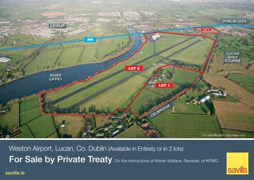
LEIXLIP<br />
LOT 2<br />
DUBLIN CITY<br />
M4<br />
LUCAN<br />
GOLF<br />
COURSE<br />
LOT 2<br />
RIVER<br />
LIFFEY<br />
LOT 1<br />
CELBRIDGE<br />
For identification purposes only.<br />
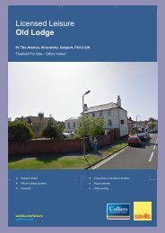
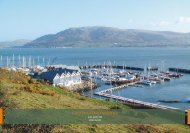
Weston Airport, Lucan, Co. Dublin (Available in Entirety or in 2 lots)<br />
For Sale by Private Treaty On the instructions of Kieran Wallace, Receiver, of KPMG<br />
savills.ie
Weston Airport, Lucan, Co. Dublin<br />
Traffic Control Tower<br />
Operations Buildings<br />
Location<br />
The property is located 17km to the west of Dublin City Centre,<br />
1 km south of Leixlip and 3.5 km north east of Celbridge.<br />
Weston Airport is located in the rural area that immediately<br />
surrounds the urban sprawl of Dublin and straddles the<br />
border between South Dublin County and County Kildare.<br />
The surrounding area is characterised by residential,<br />
commercial, amenity and agricultural uses, with the Citywest<br />
development scheme located 14km to the south-east.<br />
The property lies approximately 500 metres south of one<br />
of Ireland’s main arterial routes (M4/N4), providing excellent<br />
access to Dublin city centre and to the west. The property is<br />
also situated approximately 7 kilometres from the junction of<br />
the M4 / M50.<br />
Description<br />
Weston Airport extends to approximately 103.6ha (256 acres)<br />
in total incorporating in the region of 9,250 sq m of developed<br />
property comprising an operations building and traffic control<br />
tower, three aircraft hangars, a large house (Westonpark<br />
House), 28 stables and agricultural land. The key operational<br />
buildings were built within the last 5 years.<br />
The property is offered as follows:<br />
Weston Airport is currently operated as a private airfield, the main<br />
use being for private chartered flights to/from Dublin and for private<br />
flying and flight training, both for fixed wing aircraft and helicopters.<br />
The tarmac runway is in good condition, oriented roughly north east<br />
– south west in direction and extending to 924 metres approximately.<br />
The hangars, which were recently constructed, are to a high<br />
specification. The tower is connected to the Dublin radar system<br />
enabling safer operation of the airfield and there are approximately<br />
150 car spaces throughout the site.<br />
Westonpark House comprises an attractive two storey period<br />
dwelling with it’s own entrance driveway and gate lodge off the<br />
Celbridge Road. The property is of traditional stone and render<br />
construction under a pitched slate covered roof. The front elevation<br />
incorporates an attractive stone portico entrance and the elevation<br />
features a wrought iron balcony at first floor level. The house is in<br />
need of refurbishment and modernisation. Immediately to the front<br />
of the house is a gravel-surfaced parking area for approximately 3<br />
to 4 cars with gardens laid to lawn at the front, sides and rear of the<br />
house. The gardens are surrounded by miniature hedge boundaries<br />
with mature trees and shrubbery along the perimeters. There are<br />
walled paddocks to the front of the property together with ancillary<br />
outbuildings and stables to the rear.<br />
Westonpark House<br />
Lot 1<br />
Lot 2<br />
The<br />
Entire<br />
Large private house (Westonpark House) extending to 428 sq m (approx. 4,607 sq ft), together with<br />
28 stables, agricultural land and industrial buildings. This property sits to the south of the main airfield,<br />
beyond the Celbridge Road on approx. 11.33ha (28 acre) site.<br />
Operations building and traffic control tower extending to approx. 1,337.4 sq. m (14,396 sq. ft), three<br />
airport hangars of approx. 4,582 sq m (49,320 sq ft) and the remaining land extending to approx.<br />
92.27ha (228 acres).<br />
The entire site area of approx. 103.6ha (256 acres). Zoned objective “Greenbelt”.
LEIXLIP<br />
M4<br />
DUBLIN CITY<br />
LOT 2<br />
LOT 2<br />
LUCAN<br />
Town Planning /<br />
Development Potential<br />
The property lies within the boundaries of both<br />
South Dublin and Kildare Counties. Under the<br />
South Dublin County Development Plan 2010<br />
– 2016 the property is zoned Objective “GB”<br />
Greenbelt: “To provide a ‘Green Belt’ between<br />
development areas”.<br />
LOT 1<br />
According to the Plan, the only uses permitted<br />
in principle within this zoned area include:<br />
“aerodrome/airfield, church, halting sites / group<br />
housing or open space, although uses such as<br />
agricultural buildings, kennels, caravan parks,<br />
hospitals, hotels or residential”, inter alia, could<br />
be allowed subject to a planning consent.<br />
CELBRIDGE<br />
RIVER<br />
LIFFEY<br />
For identification purposes only.<br />
Within Kildare County Development Plan 2011 –<br />
2017, Chapter 6 outlines the council’s approach<br />
to Aerodromes and has a number of specific<br />
policies. GA 3 states that any increase or change<br />
in use will require a full assessment carried out<br />
by the Kildare County Council on the impact that<br />
may arise from the action. GA 1 does encourage<br />
the ‘extension’ or ‘improvement’ of any airport<br />
related buildings, offices or ancillary areas. GA 1<br />
also states that the Council will consult and coordinate<br />
with South Dublin Council in all matters<br />
relating to the airport.<br />
Title<br />
We understand that the property is mainly held<br />
freehold. Approximately 1.11ha (2.73 acres) is<br />
held under possessory title only.<br />
Tenancy<br />
The office facility and available hangarage,<br />
whether on the grass, apron and hangars are<br />
occupied, mainly by local and national flying<br />
clubs or training companies. They are generating<br />
a sizable rental income. Further tenancy and<br />
rental income details provided on request.
Services<br />
We understand that all mains services are available to the property including<br />
electricity, gas, water and mains drainage, and that these are sufficient for the uses<br />
of the property.<br />
Interested parties are requested to satisfy themselves on the availability and adequacy<br />
of all services.<br />
Opportunity<br />
Weston Airport is an attractive, well maintained airfield which has enjoyed a good<br />
deal of investment over the past few years, bringing with it the potential for future<br />
expansion and intensification of use.<br />
This is an excellent opportunity to acquire not only an airport, but also offers alternative<br />
opportunities to develop a private dwelling with associated agricultural sheds.<br />
Further Information and Viewings<br />
Financial Information: abbreviated trading accounts will be provided on request.<br />
Viewings are to be undertaken strictly by appointment through the selling agents, in<br />
order to avoid disruption to the business.<br />
For further information or to arrange a <strong>view</strong>ing, please contact:<br />
Not to scale - For Indentification Only<br />
<strong>Savills</strong><br />
Development Agency<br />
& Consultancy<br />
32 Molesworth Street<br />
Dublin 2<br />
savills.ie<br />
Mark Reynolds<br />
T: +353 (0)1 618 1326<br />
E: mark.reynolds@savills.ie<br />
Jonathan Preston<br />
T: +353 (0)1 618 1445<br />
E: jonathan.preston@savills.ie<br />
John Swarbrigg<br />
T: +353 (0)1 618 1333<br />
E: john.swarbrigg@savills.ie<br />
<strong>Savills</strong><br />
Airport Advisory<br />
Wytham Court<br />
11 West Way<br />
Oxford OX2 OQL<br />
savills.com<br />
James Higham<br />
T: +44 (0) 1865 269 023<br />
E: jhigham@savills.com<br />
Jill Horan<br />
T: +353 (0)1 618 1350<br />
E: jill.horan@savills.ie<br />
Co-ordinates: Lat Long 532108.76N 0062910.33W<br />
<strong>Savills</strong> Ireland and the Vendor/Lessor give note that the particulars and information contained in this brochure do not form any part of any offer or contract<br />
and are for guidance only. The particulars, descriptions, dimensions, references to condition, permissions or licences for use or occupation, access<br />
and any other details, such as prices, rents or any other outgoings are for guidance only and are subject to change. Maps and plans are not to scale and<br />
measurements are approximate. Whilst care has been taken in the preparation of this brochure intending purchasers, Lessees or any third party should<br />
not rely on particulars and information contained in this brochure as statements of fact but must satisfy themselves as to the accuracy of details given<br />
to them. Neither <strong>Savills</strong> Ireland nor any of its employees have any authority to make or give any representation or warranty (express or implied) in<br />
relation to the property and neither <strong>Savills</strong> Ireland nor any of its employees nor the vendor or lessor shall be liable for any loss suffered by an intending<br />
purchaser/Lessees or any third party arising from the particulars or information contained in this brochure. Prices quoted are exclusive of VAT (unless<br />
otherwise stated) and all negotiations are conducted on the basis that the purchasers/lessees shall be liable for any VAT arising on the transaction. This<br />
brochure is issued by <strong>Savills</strong> Ireland on the understanding that any negotiations relating to the property are conducted through it.<br />
All maps produced by permission of the Ordnance Survey Ireland Licence No AU 001799 © Government of Ireland.