Ferryden Heritage Trail - Angus Council
Ferryden Heritage Trail - Angus Council
Ferryden Heritage Trail - Angus Council

Create successful ePaper yourself
Turn your PDF publications into a flip-book with our unique Google optimized e-Paper software.
5<br />
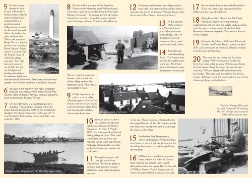
On this corner,<br />
directly in front<br />
of you, is <strong>Ferryden</strong>’s<br />
former primary school<br />
and its school house,<br />
nestling behind it.<br />
Continue along<br />
Hillview Crescent on<br />
the left hand side and<br />
follow the path to the<br />
stairs and turn right.<br />
These take you onto<br />
Rossie Terrace, leading<br />
up from the car park at<br />
Rossie Square. Rossie<br />
Square is named after<br />
the former estate of<br />
which the village<br />
was part. Turn right<br />
here and proceed<br />
up the hill. You are<br />
on the high road,<br />
Scurdieness Lighthouse<br />
leading ultimately to<br />
Scurdieness lighthouse<br />
and the mouth of the river. From here you can enjoy<br />
superb views over the harbour to the Basin beyond.<br />
6<br />
At a gap in the road on your right, a signpost<br />
indicates the location of the small United Free<br />
Church. Back on Rossie Terrace, continue along the<br />
road as it becomes Beacon Terrace.<br />
7<br />
On the right there is a small fragment of a<br />
building. This is all that remains of the old<br />
Infant School, founded in 1835 by the local laird’s<br />
daughter for village children up to the age of 5. It<br />
was Scotland’s first nursery school and still in use<br />
until the 1960s.<br />
The ferry and <strong>Ferryden</strong> from the Montrose shore c1905<br />
8<br />
On the wall is a plaque of the <strong>Ferryden</strong><br />
Fishwives by Montrose artist William Lamb,<br />
who drew many of his models from the <strong>Ferryden</strong><br />
fishing community. The remnant of the old infant<br />
school has now been topped by a new weather<br />
vane featuring a salmon. Continue along Beacon<br />
Terrace, past the colourful<br />
houses, until you are out<br />
of the village and on the<br />
lighthouse road. This road is<br />
not suitable for cars.<br />
9<br />
A little way along the<br />
path is a picnic table,<br />
affording superb views of the<br />
estuary, out to sea and inland<br />
over the harbour. Seals, birds<br />
and occasionally dolphins<br />
can be seen from here.<br />
10<br />
You can carry on down<br />
this road to Scurdieness<br />
lighthouse, designed by Robert<br />
Stevenson, first lit in 1 March<br />
1870, and then onto the deserted<br />
fishing village of Usan. This walk<br />
would take over an hour and<br />
requires you to wear appropriate<br />
footwear. Alternatively, go as far<br />
as the lighthouse and explore the<br />
rock pools.<br />
11<br />
The gable ends of <strong>Ferryden</strong><br />
Along the way you will<br />
note pill boxes from<br />
World War Two home defence<br />
schemes and the lime washed<br />
pillars that were early navigation<br />
beacons.<br />
12<br />
Continue back towards the village and on<br />
your right, just past some black huts, there is<br />
staircase that descends towards Victoria Square. Use<br />
this to reach River Street, fronting the beach.<br />
13<br />
At the junction<br />
of River Street<br />
and Victoria Square<br />
you will notice some<br />
outbuildings, a few of<br />
the last survivors of<br />
<strong>Ferryden</strong>’s huts, wash<br />
houses and bark boilers.<br />
14<br />
Turn left and<br />
walk along King<br />
Street. The houses here<br />
sit with their gable ends<br />
to the sea. All of their<br />
former inhabitants were<br />
fishermen or connected<br />
to the sea. These houses are believed to be<br />
the original houses of the 18th century north<br />
east fishermen immigrants, and are amongst<br />
the oldest in the village.<br />
15<br />
Just before King Street turns a<br />
corner and becomes William Street,<br />
one house on the left still has the housing for<br />
the village barometer, so vital for predicting<br />
the weather.<br />
16<br />
River Street<br />
William Street itself is an attractive<br />
street, where a number of houses<br />
have retained the outside stairs, which<br />
allowed access to the upper flats. At the end<br />
of William Street is Rossie Square, part of<br />
which was demolished to create a car park.<br />
17<br />
As you reach the junction with Brownlow<br />
Place, you pass a gap between the Post<br />
Office and the row of old sheds.<br />
18<br />
Along Brownlow Place is the Esk Hotel,<br />
<strong>Ferryden</strong>’s oldest surviving drinking<br />
establishment. At one time the village had a problem<br />
with the over consumption of alcohol until the<br />
Reverend Brewster inspired a Temperance fervour<br />
in the villagers.<br />
19<br />
Opposite the Church Hall is the Memorial<br />
Garden and Picture Board, opened in April<br />
2001 and landscaped to provide a pleasant outlook<br />
over the river and harbour.<br />
20<br />
This was the site where the ferryboat<br />
landed. Mill workers used to take the<br />
ferry four times a day as many of them came home<br />
for their dinner. From here you can see the pier,<br />
with the 1795 pier clearly still visible below the<br />
bus shelter. This area was once full of the fishing<br />
vessels. We have come full circle and our tour of this<br />
charming village concludes here.<br />
“Menim” George West and<br />
his wife “Meg Nicoll” baiting<br />
the line. George was coxswain<br />
of the lifeboat at one time.