Eagle-Snowshoe Conservation Reserve - Ontario Parks
Eagle-Snowshoe Conservation Reserve - Ontario Parks
Eagle-Snowshoe Conservation Reserve - Ontario Parks

Create successful ePaper yourself
Turn your PDF publications into a flip-book with our unique Google optimized e-Paper software.
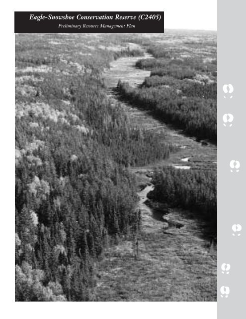
<strong>Eagle</strong>-<strong>Snowshoe</strong> <strong>Conservation</strong> <strong>Reserve</strong> (C2405)<br />
Preliminary Resource Management Plan
© 2006, Queen’s Printer for <strong>Ontario</strong><br />
Printed in <strong>Ontario</strong>, Canada
<strong>Eagle</strong>-<strong>Snowshoe</strong> <strong>Conservation</strong> <strong>Reserve</strong><br />
i
<strong>Eagle</strong>-<strong>Snowshoe</strong> <strong>Conservation</strong> Resesrve<br />
Table of Contents<br />
1.0 Introduction...............................................................................................................................................1<br />
1.1 Background ....................................................................................................................................1<br />
1.2 Resource Management Plan............................................................................................................1<br />
2.0 Planning Area...........................................................................................................................................1<br />
2.1 Site Location ..................................................................................................................................1<br />
2.2 <strong>Conservation</strong> <strong>Reserve</strong> Description....................................................................................................2<br />
2.3 Regional Setting.............................................................................................................................2<br />
3.0 Management Planning .............................................................................................................................3<br />
3.1 Goal and Objectives ........................................................................................................................3<br />
3.2 Methods .........................................................................................................................................3<br />
3.3 Survey of <strong>Conservation</strong> <strong>Reserve</strong> Values............................................................................................3<br />
3.4 Project Planning Team ...................................................................................................................3<br />
3.5 Advisory Committee .......................................................................................................................4<br />
3.6 Public Consultation.........................................................................................................................4<br />
4.0 Management Direction.............................................................................................................................6<br />
4.1 First Nations..................................................................................................................................6<br />
4.2 Lands and Waters Resource Use......................................................................................................6<br />
4.2.1 Aggregate Extraction .......................................................................................................6<br />
4.2.2 Energy Transmissions and Communications Corridors.......................................................6<br />
4.2.3 Commercial Hydro Development ......................................................................................6<br />
4.2.4 Mineral Exploration and Development .............................................................................6<br />
4.2.5 Peat Extraction................................................................................................................7<br />
4.2.6 Commercial Tourism ........................................................................................................7<br />
4.2.7 Private Recreation Camps (Hunt Camps) .........................................................................7<br />
4.2.8 Campgrounds.................................................................................................................18<br />
4.2.9 Overnight Camping.......................................................................................................18<br />
4.2.10 Campsite Designation.....................................................................................................18<br />
4.2.11 Access Roads ...................................................................................................................18<br />
4.2.12 Crown Land Dispositions................................................................................................19<br />
4.2.13 Type B Outpost Camps/Restricted Land Use Permits.......................................................19<br />
4.2.14 Boat Caches....................................................................................................................19<br />
4.2.15 Trail Development .........................................................................................................10<br />
4.2.16 Signage..........................................................................................................................10<br />
4.2.17 Non-Motorized Recreational Travel................................................................................10<br />
iii
4.3 Fisheries ......................................................................................................................................11<br />
4.3.1 Commercial Fishing .......................................................................................................11<br />
4.3.2 Bait-fish/Leech Harvesting.............................................................................................11<br />
4.3.3 Sport Fishing .................................................................................................................11<br />
4.3.4 Fish Stocking .................................................................................................................12<br />
4.3.5 Fish Habitat Management .............................................................................................12<br />
4.4 Forest Resources............................................................................................................................12<br />
4.4.1 Commercial Timber Harvest..........................................................................................12<br />
4.4.2 Insect/Disease Suppression ..............................................................................................12<br />
4.4.3 Fuelwood and other small scale uses.................................................................................13<br />
4.4.4 Vegetation Management.................................................................................................13<br />
4.4.5 Fire Suppression.............................................................................................................13<br />
4.4.6 Prescribed Burning.........................................................................................................14<br />
4.5 Wildlife Resources.........................................................................................................................14<br />
4.5.1 Commercial Fur Harvesting ..........................................................................................15<br />
4.5.2 Commercial Bear Hunting.............................................................................................15<br />
4.5.3 Hunting ........................................................................................................................15<br />
4.5.4 Wildlife Population Management...................................................................................15<br />
4.5.5 Wildlife Viewing............................................................................................................16<br />
4.6 Other Alternate Uses....................................................................................................................16<br />
4.6.1 Collecting.......................................................................................................................16<br />
4.6.2 Food Harvesting (Commercial).......................................................................................16<br />
4.6.3 Food Gathering (Personal) .............................................................................................16<br />
4.6.4 Historical Appreciation...................................................................................................16<br />
4.6.5 Inventory/Monitoring ....................................................................................................17<br />
4.6.6 Wild Rice Harvesting.....................................................................................................17<br />
5.0 Amendments to Resource Management Plan........................................................................................18<br />
6.0 References.................................................................................................................................................18<br />
List of Appendices<br />
Appendix ESCR-1: Permitted Uses Summary Table ..................................................................................19<br />
Appendix ESCR-2: Test of Compatability...................................................................................................23<br />
Appendix ESCR-3: Bait-fish/Leech harvest blocks of ESCR (C2405) .........................................................24<br />
List of Figures<br />
Figure ESCR-1: Traplines..........................................................................................................................25<br />
Figure ESCR-2: Fire History .....................................................................................................................26<br />
Figure ESCR-3: Bear Management Areas..................................................................................................27<br />
iv
<strong>Eagle</strong>-<strong>Snowshoe</strong> <strong>Conservation</strong> Resesrve<br />
1.0 Introduction 2.0 Planning Area<br />
1.1 Background<br />
2.1 Site Location<br />
<strong>Eagle</strong>-<strong>Snowshoe</strong> <strong>Conservation</strong> <strong>Reserve</strong> was selected for<br />
protection through <strong>Ontario</strong>’s Living Legacy Land Use<br />
Strategy and was regulated on May 21, 2003.<br />
<strong>Conservation</strong> <strong>Reserve</strong>s are established and regulated<br />
under the Public Lands Act. These areas are intended<br />
to complement provincial parks in protecting<br />
representative natural areas and special landscapes.<br />
The ‘conservation reserve’ designation provides<br />
management direction to permit many existing land use<br />
activities to continue<br />
1.2 Resource Management Plan<br />
The <strong>Eagle</strong>-<strong>Snowshoe</strong> <strong>Conservation</strong> <strong>Reserve</strong> is located<br />
within the Kenora District of the Northwest Region of<br />
<strong>Ontario</strong>’s Ministry of Natural Resources (MNR). It is<br />
approximately 95 kilometres northwest of the City of<br />
Kenora. This protected area includes the area from<br />
<strong>Snowshoe</strong> Lake along the <strong>Ontario</strong>/Manitoba border,<br />
and northeast along a chain of lakes including Chase<br />
Lake and Midway Lake, and then ends at <strong>Eagle</strong> Lake<br />
where it meets the Woodland Caribou Provincial Park<br />
boundary. The conservation reserve is part of the<br />
Woodland Caribou Signature Site and will contribute<br />
to ensuring the ecological integrity of the area.<br />
This resource management plan provides long-term<br />
management direction for resource based activities<br />
occurring within the conservation reserve. The plan<br />
was developed in accordance with <strong>Conservation</strong> <strong>Reserve</strong>s<br />
Policy and Procedures (1997) as amended by the <strong>Ontario</strong>’s<br />
Living Legacy Land Use Strategy (1999) and considers<br />
the associated recreation inventory, life science<br />
inventory and earth science inventory. The goal and<br />
objectives of the conservation reserve are identified<br />
within the resource management plan and where policy<br />
is limited, these goals and objectives will guide resource<br />
management planning for the protected area.<br />
The management direction contained in this document<br />
will be reflected through amendment of the Crown<br />
Land Use Policy Atlas which is MNR's repository of<br />
current area-specific land use policies for Crown lands<br />
in the central part of <strong>Ontario</strong>. It identifies the basic<br />
land use intent and permitted uses for each of the<br />
designated areas. The intended direction to be reflected<br />
in the Crown Land Use Policy Atlas is included in<br />
Appendix ESCR – 1.<br />
Wabaseemoong Independent Nations represents the<br />
Aboriginal interests in the area of the conservation<br />
reserve.<br />
The <strong>Eagle</strong>-<strong>Snowshoe</strong> <strong>Conservation</strong> <strong>Reserve</strong> is located<br />
within the North Kenora Pilot Project Agreement<br />
Area. This agreement was established through the<br />
Alternative Dispute Resolution provisions contained<br />
within the Forest Management Planning process in an<br />
attempt to resolve a forestry – tourism conflict resulting<br />
from a proposed forest access road and bridge crossing<br />
between Sydney and Rowdy Lakes to access wood in<br />
the north part of the Kenora Forest. The provisions<br />
contained within this agreement reflect the efforts of all<br />
potential users of this area to reach agreement on<br />
unique regulations affecting access, sport fishing,<br />
Crown land camping, and hunting in this area. The<br />
agreement is based upon the premise that a proposed<br />
forest access road west of Sydney Lake could affect the<br />
resource based tourism industry in this area. Since<br />
access west of Sydney Lake has not been established<br />
and is no longer proposed, and the term of the<br />
agreement has expired, the regulation changes made<br />
will be revisited and those remaining as proposed will<br />
not be implemented..<br />
1
2.2 <strong>Conservation</strong> <strong>Reserve</strong> Description<br />
2.3 Regional Setting<br />
<strong>Eagle</strong>-<strong>Snowshoe</strong> <strong>Conservation</strong> <strong>Reserve</strong> is 35,621<br />
hectares in size. Patent properties are not included in<br />
the protected area boundary.<br />
The <strong>Eagle</strong>-<strong>Snowshoe</strong> <strong>Conservation</strong> <strong>Reserve</strong> contains<br />
representative examples of Canadian Shield topography<br />
including a glaciated landscape characterized by<br />
elongated lake systems, sudden changes in elevations,<br />
erratic drainage patterns, thin soils, and massive<br />
bedrock. The vegetation within the reserve is<br />
representative of the Southern Boreal Forest Region.<br />
<strong>Eagle</strong>-<strong>Snowshoe</strong> <strong>Conservation</strong> <strong>Reserve</strong> is located in the<br />
northwest region of the Province of <strong>Ontario</strong>. Please<br />
refer to Figure WCSS-1 for a map of the regional<br />
setting of this protected area.<br />
Established protected areas within close proximity to<br />
<strong>Eagle</strong>-<strong>Snowshoe</strong> <strong>Conservation</strong> <strong>Reserve</strong> include:<br />
■ Musk Lake <strong>Conservation</strong> <strong>Reserve</strong> (C2382)<br />
■ Campfire River <strong>Conservation</strong> <strong>Reserve</strong> (C2368)<br />
■ Solitary Lake <strong>Conservation</strong> <strong>Reserve</strong> (C2362)<br />
■ Woodland Caribou Provincial Park (P2370)<br />
The conservation reserve supports a wide variety of<br />
wildlife including moose, white-tailed deer, black bear,<br />
various small game animals, and furbearers such as<br />
beaver, otter, marten, and fisher. In addition, this area<br />
contains important woodland caribou habitat and<br />
several calving/nursery areas have been confirmed<br />
along the <strong>Eagle</strong> Lake to Chase Lake corridor. This<br />
corridor also provides an important migration route for<br />
these caribou.<br />
This area provides some of the highest quality<br />
recreational fishing opportunities in the Kenora<br />
District for walleye, northern pike, and lake trout.<br />
Angling serves to sustain seven outpost camps which<br />
contribute to the economy of the region. In addition to<br />
fishing, the conservation reserve provides opportunities<br />
for hunting, camping, and snowmobiling.<br />
There are a few established campsites on various lakes<br />
within the reserve that can be accessed by water. There<br />
is also a high potential for canoeing within <strong>Eagle</strong>-<br />
<strong>Snowshoe</strong> <strong>Conservation</strong> <strong>Reserve</strong> as it is located<br />
between Nopiming Provincial Park in Manitoba and<br />
Woodland Caribou Provincial Park in <strong>Ontario</strong>. Both<br />
of these parks actively promote canoeing.<br />
The <strong>Eagle</strong>-<strong>Snowshoe</strong> <strong>Conservation</strong> <strong>Reserve</strong> forms part<br />
of the Woodland Caribou Signature Site, one of nine<br />
featured areas identified for protection through<br />
<strong>Ontario</strong>’s Living Legacy Land Use Strategy (1999).<br />
These featured areas are places of outstanding natural<br />
beauty and significant cultural value which provide<br />
high-quality wilderness recreation opportunities and<br />
tourism potential. The Woodland Caribou Signature<br />
Site is located in northwestern <strong>Ontario</strong>, approximately<br />
30 kilometres west of the municipality of Red Lake, 90<br />
kilometres north of the city of Kenora and 60<br />
kilometres south of the community of Pikangikum. It<br />
consists of 537,585 hectares of protected land which<br />
includes Woodland Caribou Provincial Park, four<br />
proposed wilderness park additions, <strong>Eagle</strong>-<strong>Snowshoe</strong><br />
<strong>Conservation</strong> <strong>Reserve</strong>, Pipestone Bay-McIntosh<br />
Enhanced Management Area (E2359a), and a forest<br />
reserve. Please refer to Figure WCPP-1 for a map of<br />
the signature site.<br />
This resource management plan for <strong>Eagle</strong>-<strong>Snowshoe</strong><br />
<strong>Conservation</strong> was developed as part of the planning for<br />
the Woodland Caribou Signature Site Strategy.<br />
However, the MNR, Kenora District will maintain<br />
administrative responsibility for the conservation<br />
reserve, including the periodic review of the approved<br />
Resource Management Plan.<br />
2
<strong>Eagle</strong>-<strong>Snowshoe</strong> <strong>Conservation</strong> Resesrve<br />
3.0 Management Planning<br />
3.1 Goal and Objectives<br />
The primary goal guiding the development of this<br />
resource management plan is to provide permanent<br />
protection for natural and cultural heritage values in<br />
the area while permitting compatible land use activities<br />
to continue.<br />
The objectives of the resource management plan are to:<br />
1. Identify the natural heritage values associated with<br />
the <strong>Eagle</strong>-<strong>Snowshoe</strong> conservation reserve, including<br />
life science, earth science, and documented<br />
historical, cultural, and archaeological values.<br />
2. Identify the resource uses/users and recreational<br />
activities taking place within the conservation<br />
reserve boundaries.<br />
3. Develop a set of guidelines to manage activities of<br />
resource users so that the natural and cultural<br />
heritage features of the area are protected.<br />
4. Ensure the protection of habitat and vegetation that<br />
supports the woodland caribou population that use<br />
the area.<br />
3.2 Methods<br />
This resource management plan was developed and is<br />
maintained through the following steps:<br />
1. Preparation of Terms of Reference<br />
2. Background Information preparation<br />
3. Compilation and review of issues and options<br />
4. Preparation of Preliminary Resource Management<br />
Plan<br />
5. Preparation and approval of the Final Resource<br />
Management Plan<br />
6. Periodic review of the approved Resource<br />
Management Plan<br />
Public consultation efforts were coordinated with those<br />
for the Woodland Caribou Signature Site.<br />
3.3 Survey of <strong>Conservation</strong> <strong>Reserve</strong> Values<br />
Natural and cultural heritage data for the <strong>Eagle</strong>-<br />
<strong>Snowshoe</strong> <strong>Conservation</strong> <strong>Reserve</strong> were acquired through<br />
surveys and research. The compilation of this<br />
information provides a basis for developing effective<br />
management direction and also directly contributes to<br />
the objectives of this Resource Management Plan. The<br />
following section identifies the inventory work and<br />
surveys that have been completed to date.<br />
1. Detailed Life Science inventory and checksheet<br />
compiled March 2001 by Northern Bioscience.<br />
2. Detailed Earth Science inventory and checksheet<br />
compiled March, 2001 by Blackburn Geological<br />
Services.<br />
3. Recreation Resource Inventory compiled January,<br />
2001 by MNR.<br />
4. Aerial field inspection to verify values and locations<br />
completed September 2003 by MNR.<br />
3.4 Project Planning Team<br />
The Signature Site Planning Team is comprised of<br />
<strong>Ontario</strong> government staff representing relevant<br />
ministries and program areas. The Planning Team<br />
contributed knowledge and provided clarification to<br />
policy, programs, and procedures throughout the<br />
planning process. The Ministry of Natural Resources<br />
(Northwest Region, Red Lake District, and Kenora<br />
District) and the Ministry of Northern Development<br />
and Mines (Northern Development and Mineral<br />
sectors), were represented on the team.<br />
3
3.5 Advisory Committee<br />
An advisory committee was established in January 2003.<br />
It is made up of representatives with a wide range of<br />
interests and takes local, regional, and provincial<br />
perspectives into account. The advisory committee has<br />
established an approved operating procedure protocol,<br />
reviewed background information, agreed upon a vision<br />
statement for the signature site, identified issues and<br />
suggested options for the management of the site.<br />
3.6 Public Consultation<br />
Stage 2 – Public review of Background Information<br />
February 2004<br />
Public comments received through the first stage of<br />
public consultation were considered and incorporated,<br />
where appropriate, into the Background Information<br />
document. This document was available for public<br />
review and open houses were held in the communities<br />
of Ear Falls, Red Lake, Pikangikum, Kenora, Grassy<br />
Narrows, Kejick Bay, and Wabaseemoong between<br />
February and March 2004. Responses were used by the<br />
Project Planning Team to assist in identifying issues<br />
and alternatives.<br />
Public consultation for the <strong>Eagle</strong>-<strong>Snowshoe</strong><br />
<strong>Conservation</strong> <strong>Reserve</strong> Resource Management Plan was<br />
undertaken in conjunction with consultation on the<br />
Woodland Caribou Signature Site Strategy. The<br />
following list identifies the individuals and groups that<br />
have an interest in the signature site. This list includes<br />
those that are directly affected or influenced by decisions<br />
relating to this protected area (alphabetical order).<br />
Stage 3 – Public review of Issues and Options<br />
May – June 2005<br />
Public comments collected through the first two phases<br />
of public consultation were reviewed, summarized and<br />
compiled into the Issues and Options document and<br />
questionnaire. A series of information sessions were<br />
held in May 2005 to present this package and public<br />
comment was received until June 24, 2005.<br />
■ Bear management area holders<br />
■ Commercial tourism operators<br />
■ First Nations communities<br />
■ Forest management companies<br />
■ Mining companies<br />
■ Property owners<br />
■ Recreationalists (i.e. anglers, hunters, canoeists, and<br />
campers)<br />
■ Resource harvesters (trapline holders, bait-fish and<br />
leech licence holders)<br />
Public consultation occurred throughout the planning<br />
process and the following identifies and describes the<br />
formal opportunities for the public to provide input.<br />
Public Consultation Process<br />
Stage 1 – Invitation to Participate<br />
December 2002<br />
The Terms of Reference for the signature site were<br />
made available for public review and comment at this<br />
stage of consultation. Potential issues and public<br />
concerns that could be addressed through resource<br />
management planning were also identified through the<br />
Invitation to Participate. A summary of this public<br />
consultation stage is available upon request.<br />
4
<strong>Eagle</strong>-<strong>Snowshoe</strong> <strong>Conservation</strong> Resesrve<br />
Stage 4 – Public review of Preliminary Signature Site<br />
Strategy, including <strong>Eagle</strong>-<strong>Snowshoe</strong> <strong>Conservation</strong><br />
<strong>Reserve</strong> draft Resource Management Plan<br />
Dates to be determined<br />
Public response to the Issues and Options package will<br />
be considered in the development of the draft Resource<br />
Management Plan (RMP). The draft RMP will be<br />
presented to the public as part of the Preliminary<br />
Signature Site Strategy and comments will be solicited<br />
through information sessions and the Environmental<br />
Bill of Rights Registry.<br />
Stage 5 – Public Inspection of Approved Signature Site<br />
Strategy, including <strong>Eagle</strong>-<strong>Snowshoe</strong> <strong>Conservation</strong><br />
<strong>Reserve</strong> Resource Management Plan<br />
Dates to be determined<br />
The approved strategy document, including the<br />
resource management plan, will be made available to<br />
the public.<br />
5
4.0 Management Direction<br />
4.2.2 Energy Transmissions and<br />
Communications Corridors<br />
No transmission lines or gas pipeline corridors exist<br />
within the <strong>Eagle</strong>-<strong>Snowshoe</strong> <strong>Conservation</strong> <strong>Reserve</strong>.<br />
The following management direction for the<br />
conservation reserve is in accordance with <strong>Ontario</strong>’s<br />
Living Legacy Land Use Strategy and <strong>Conservation</strong><br />
<strong>Reserve</strong>s Policy and Procedures. All new activities<br />
within the conservation reserve are subject to the Class<br />
Environmental Assessment for Provincial <strong>Parks</strong> and<br />
<strong>Conservation</strong> <strong>Reserve</strong>s.<br />
Management Direction:<br />
Utility corridors will not be permitted within the<br />
conservation reserve unless there are no demonstrated<br />
alternatives. In this event, the maintenance of such<br />
corridors, such as vegetation removal, will be<br />
permitted. Ancillary activities such as pumping stations<br />
and service yards will not be permitted within the site.<br />
4.1 First Nations<br />
<strong>Eagle</strong>-<strong>Snowshoe</strong> <strong>Conservation</strong> <strong>Reserve</strong> is within the<br />
Treaty 3 area. There are several First Nations<br />
communities and associated Federal <strong>Reserve</strong> Lands that<br />
are close to the conservation area. These First Nations<br />
communities have been included in public consultation<br />
efforts relating to the signature site. This resource<br />
management plan recognizes that the health and<br />
welfare of these established communities is intrinsically<br />
linked to the natural resources of the area. Nothing in<br />
this resource management plan shall be construed so as<br />
to abrogate or derogate from the protection provided<br />
for the existing aboriginal or treaty rights of the<br />
aboriginal people of Canada as recognized and affirmed<br />
in section 35 of the Constitution Act, 1982.<br />
4.2 Lands and Waters Resource Use<br />
4.2.3 Commercial Hydro Development<br />
Previous hydro development has not occurred within<br />
the conservation reserve. This may be attributed to the<br />
geographic location of the protected area and the lack<br />
of road access to the site.<br />
Management Direction:<br />
Commercial hydroelectric development or ancillary<br />
activities (i.e. flood-ways) will not be permitted within<br />
the <strong>Eagle</strong>-<strong>Snowshoe</strong> <strong>Conservation</strong> <strong>Reserve</strong>.<br />
4.2.4 Mineral Exploration and<br />
Development<br />
No mineral exploration or extraction activities are<br />
permitted to occur within any conservation reserve,<br />
however, there are twenty (20) established patented<br />
mining claims surrounded by the conservation reserve<br />
boundary.<br />
4.2.1 Aggregate Extraction<br />
No aggregate extraction sites have been developed<br />
within the <strong>Eagle</strong>-<strong>Snowshoe</strong> <strong>Conservation</strong> <strong>Reserve</strong>.<br />
Management Direction:<br />
Aggregate extraction will not be permitted within the<br />
conservation.<br />
Management Direction:<br />
The mining and surface rights of the lands and lands<br />
under water within the conservation reserve boundary<br />
are withdrawn from prospecting, staking out, sale or<br />
lease by the Ministry of Northern Development and<br />
Mines (MNDM). Therefore, mineral exploration and<br />
development activities are not permitted within the<br />
conservation reserve. Likewise, ancillary activities<br />
associated with mineral exploration are not supported<br />
by this management plan. Necessary access to existing<br />
mining tenure for future mineral exploration and/or<br />
mining development will be permitted in the<br />
conservation reserve.<br />
6
<strong>Eagle</strong>-<strong>Snowshoe</strong> <strong>Conservation</strong> Resesrve<br />
However, the twenty existing patents surrounded by the<br />
conservation reserve boundary are excluded from the<br />
protected area. In the event that these patented parcels<br />
are released to the Crown in the future, the Ministry of<br />
Natural Resources would consider options to<br />
incorporate this area(s) into the conservation reserve,<br />
provided that all the necessary steps are followed under<br />
the Class Environmental Assessment for Provincial <strong>Parks</strong><br />
and <strong>Conservation</strong> <strong>Reserve</strong>s and the Crown Land Use<br />
Atlas policy amendment procedures.<br />
4.2.5 Peat Extraction<br />
Peat extraction activities will not be permitted within<br />
the conservation reserve.<br />
4.2.6 Commercial Tourism<br />
Commercial tourism includes resorts and lodges,<br />
outpost camps, guided non-resident bear hunting, and<br />
outfitting services. Outfitting services include the<br />
provision of recreational equipment such as canoes and<br />
boats to resource users.<br />
Currently, there are eight commercial tourist<br />
establishments located within the conservation reserve<br />
boundary. Six of the eight facilities occur on land use<br />
permits, one occurs on leased property, and one exists<br />
on patent land.<br />
The conservation reserve is located within the North<br />
Kenora Pilot Project Agreement Area which has been<br />
proposed as a ‘green zone’ under the Public Lands Act.<br />
This designation requires that non-residents of Canada<br />
who stay overnight within the conservation reserve<br />
must be accommodated by a registered tourism<br />
operator.<br />
Management Direction:<br />
Existing tourism operations are permitted to continue<br />
unless there are significant demonstrated conflicts.<br />
Requests for expansion or relocation of existing<br />
facilities may be considered subject to the ‘test of<br />
compatibility’ (see APPENDIX ESCR-2) and provided<br />
that there are demonstrated net benefits to the<br />
signature site. Tourism operators may apply for<br />
upgraded tenure, but not for patents.<br />
The commercial tourism establishment occurring on<br />
patent land is also permitted to continue and it should<br />
be noted that management direction within this plan<br />
does not apply to activity on private property.<br />
Commercial tourism facilities will continue to be<br />
regulated under the Tourism Act.<br />
No new permanent roofed accommodations will be<br />
permitted within the conservation reserve.<br />
New ecotourism opportunities may be considered on a<br />
case-by-case basis and will be subject to the ‘test of<br />
compatibility’. Any associated dispositions will require<br />
the proponent to follow the appropriate process<br />
outlined in the Class Environmental Assessment for<br />
Provincial <strong>Parks</strong> and <strong>Conservation</strong> <strong>Reserve</strong>s and to<br />
demonstrate that there would be no negative impacts<br />
on the values for which the conservation reserve was<br />
designated.<br />
This management plan recommends that the proposed<br />
non-resident no-camping restriction or “green zone”<br />
not be implemented for the area. This is intended to<br />
increase tourism opportunities for canoe outfitters by<br />
allowing their clients to overnight camp within the<br />
conservation reserve.<br />
4.2.7 Private Recreation Camps (Hunt<br />
Camps)<br />
There are no existing recreational hunt camps located<br />
within the <strong>Eagle</strong>-<strong>Snowshoe</strong> <strong>Conservation</strong> <strong>Reserve</strong><br />
boundary.<br />
Management Direction:<br />
No new hunt camps will be permitted within the<br />
conservation reserve as per <strong>Conservation</strong> <strong>Reserve</strong>s<br />
Policy. This management direction only applies to<br />
tenured hunt camps and is not applicable to camping<br />
on Crown land for the purpose of hunting.<br />
7
4.2.8 Campgrounds<br />
There are no existing commercial campgrounds located<br />
within the <strong>Eagle</strong>-<strong>Snowshoe</strong> <strong>Conservation</strong> <strong>Reserve</strong>.<br />
Management Direction:<br />
This management plan does not support the<br />
development of commercial campgrounds within the<br />
<strong>Eagle</strong>-<strong>Snowshoe</strong> <strong>Conservation</strong> <strong>Reserve</strong>. New<br />
commercial campgrounds may not be consistent with<br />
the goal of maintaining the remote character of the<br />
area. Furthermore, limited access to the area indicates<br />
that commercial campgrounds could be better<br />
accommodated outside the conservation reserve.<br />
4.2.9 Overnight Camping<br />
No campsites are signed or designated and campers are<br />
not directed to specific camping locations within the<br />
<strong>Conservation</strong> <strong>Reserve</strong>. There are a substantial number<br />
of camping opportunities which are generally clearly<br />
marked by previous use. The sites are well used and are<br />
in good condition although some debris is occasionally<br />
left on site. <strong>Eagle</strong>-<strong>Snowshoe</strong> <strong>Conservation</strong> <strong>Reserve</strong> is<br />
located within a proposed non-resident no-camping<br />
zone which excludes non-residents of Canada from<br />
camping on Crown Land in the area.<br />
Management Direction:<br />
Overnight camping is permitted within the<br />
conservation reserve. No further management action is<br />
required at this time other than the implementation of<br />
the appropriate regulations as they pertain to such<br />
activities.<br />
4.2.10 Campsite Designation<br />
The designation of campsites would result in additional<br />
administrative and enforcement requirements for the<br />
MNR and some level of site maintenance would be<br />
necessary. The recreation inventory identifies that<br />
there are a substantial number of camping<br />
opportunities which are generally clearly marked by<br />
previous use. The sites are well used and are in good<br />
condition although some debris is occasionally left<br />
on site.<br />
Management Direction:<br />
This management plan will continue to support<br />
recreational camping within the <strong>Eagle</strong>-<strong>Snowshoe</strong><br />
<strong>Conservation</strong> <strong>Reserve</strong>. Due to administrative and<br />
enforcement constraints, the designation and<br />
maintenance of campsites within the conservation reserve<br />
is not feasible, nor required at this time. However, this<br />
management plan supports efforts to increase awareness<br />
of low-impact camping practices through education.<br />
These efforts could include the distribution of pamphlets<br />
that promote packing out all garbage and refraining from<br />
using cans and bottles on trips.<br />
4.2.11 Access Roads<br />
<strong>Eagle</strong>-<strong>Snowshoe</strong> <strong>Conservation</strong> <strong>Reserve</strong> is located in a<br />
remote location 95 kilometres northwest from the City<br />
of Kenora. There are no roads and/or trails which<br />
provide vehicle access directly into the site. The<br />
nearest road to the conservation reserve is Werner Lake<br />
Road which is located approximately 15 kilometers<br />
south from <strong>Snowshoe</strong> Lake.<br />
Should changes to the regulations governing overnight<br />
camping be made, they should be considerate of the<br />
intent of this resource management plan, however, they<br />
will follow the appropriate processes which are outside<br />
the amendment procedures of this document<br />
Management Direction:<br />
New resource access roads will not be permitted within<br />
the conservation reserve, with the exception of<br />
necessary access to existing mining tenure for future<br />
mineral exploration and/or mining development.<br />
This management plan recommends that the proposed<br />
non-resident no-camping restriction or “green zone”<br />
that was proposed in the North Kenora Pilot Project<br />
Agreement not be implemented for the area. This is<br />
intended to increase tourism opportunities for canoe<br />
outfitters by allowing their clients to overnight camp<br />
within the conservation reserve.<br />
8
<strong>Eagle</strong>-<strong>Snowshoe</strong> <strong>Conservation</strong> Resesrve<br />
4.2.12 Crown Land Dispositions<br />
There are a number of patented properties which exist<br />
within the conservation reserve. These properties are<br />
the result of patented mining claims which have been<br />
sold to independent owners and operators. As a result,<br />
there are three private cottages and one commercial<br />
tourist operation which exist within the conservation<br />
reserve. Other land dispositions include one Crown<br />
land lease and six land use permits, all of which are<br />
registered to commercial tourism operations occurring<br />
within the <strong>Eagle</strong>-<strong>Snowshoe</strong> area.<br />
Management Direction:<br />
Renewals of existing land use permits and leases will be<br />
permitted. Requests for transfers may be considered.<br />
The sale of Crown land is not permitted with the<br />
exception of some types of minor dispositions to<br />
support existing permitted uses e.g. the sale of small<br />
parcels of land to provide adequate area for the<br />
installation of a septic system. The proponent will be<br />
required to demonstrate that the activity does not<br />
negatively impact the values which the conservation<br />
reserve is intended to protect.<br />
New leases or land use permits to support approved<br />
activities may be considered subject to the ‘test of<br />
compatibility’. Any such dispositions will require the<br />
proponent to follow the appropriate process outlined in<br />
the Class Environmental Assessment for Provincial <strong>Parks</strong><br />
and <strong>Conservation</strong> <strong>Reserve</strong>s and to demonstrate that there<br />
would be no negative impacts on the values for which<br />
the conservation reserve was designated. New leases or<br />
land use permits will not be considered for facilities<br />
which provide for overnight accommodation unless<br />
otherwise stated in the management direction.<br />
4.2.13 Type B Outpost Camps/Restricted<br />
Land Use Permits<br />
Type B Outpost Camp (formerly referred to as<br />
Restricted or mini-land use permit) means an<br />
encampment of structures temporarily established on<br />
Crown land to provide accommodations to clients of an<br />
operator, for a non-recurring, short-term, single<br />
purpose site. Type B outpost camps provide the<br />
tourism operator with greater flexibility and increased<br />
opportunity. If Type B outpost camps are permitted<br />
within the conservation reserve, these land disposition<br />
opportunities could be used to promote existing<br />
tourism facilities within the conservation reserve,<br />
encourage new tourism opportunities, or accommodate<br />
operators that are displaced from Woodland Caribou<br />
Provincial Park.<br />
Management Direction:<br />
New dispositions for Type B Outpost Camps may be<br />
considered within the conservation reserve. Any such<br />
dispositions will require the proponent to follow the<br />
appropriate process outlined in the Class Environmental<br />
Assessment for Provincial <strong>Parks</strong> and <strong>Conservation</strong> <strong>Reserve</strong>s<br />
and to demonstrate that there would be no negative<br />
impacts on the values for which the conservation<br />
reserve was designated. Consideration will be given to<br />
operators who can demonstrate that a net benefit to the<br />
Woodland Caribou Signature Site will be achieved<br />
through the disposition.<br />
4.2.14 Boat Caches<br />
A boat cache program was implemented in the<br />
Northwest Region in 1981 which required all boats<br />
cached on Crown land to display a decal with an<br />
assigned identification number. Boat caches are<br />
classified into three categories; commercial, resource<br />
harvester, and recreational/private.<br />
Commercial boat caches are used to support commercial<br />
tourism activities such as angling and hunting. The<br />
authority holder must be either a tourist operator<br />
licensed under the Tourism Act, or a houseboat<br />
operator with four or more rental units, or a licensed<br />
air carrier.<br />
Resource harvester boat caches are those that are utilized in<br />
support of commercial bait fishing and/or fur<br />
harvesting activities. The authority holder must hold a<br />
valid licence or have approval for the commercial<br />
harvest or utilization of natural resources, and must<br />
require the use of a boat.<br />
9
Recreational boat caches are used to support personal<br />
recreational activities. Recreational boat cache<br />
authority can only be held by residents of <strong>Ontario</strong> or<br />
non-residents who require the use of a boat to access<br />
private property.<br />
Management Direction<br />
Existing boat cache authority is permitted to continue<br />
unless resource sustainability is at risk or there are<br />
significant demonstrated conflicts. New resource<br />
harvester boat caches may be considered subject to the<br />
‘test of compatibility’. New commercial tourism and<br />
private boat cache authority may be considered if it<br />
provides demonstrated net benefits to the Woodland<br />
Caribou Signature Site.<br />
Any such dispositions will require the proponent to<br />
follow the appropriate process outlined in the Class<br />
Environmental Assessment for Provincial <strong>Parks</strong> and<br />
<strong>Conservation</strong> <strong>Reserve</strong>s and to demonstrate that there<br />
would be no negative impacts on the values for which<br />
the conservation reserve was designated.<br />
4.2.15 Trail Development<br />
Land-based trails and portages exist within the<br />
conservation reserve including portions of snowmobile<br />
and canoe routes. Other trails exist to allow fur<br />
harvesters access to their trapline areas. During the<br />
winter the frozen waterbodies also provide a means of<br />
snowmobile access to the conservation reserve. Please<br />
refer to Figure ESCR-1 for a map of documented trails<br />
within the conservation reserve as derived from the<br />
Natural Resource Values Information System (NRVIS).<br />
These trails represent routes that may be shared by<br />
canoeists and snowmobiles. There may be existing trails<br />
not captured through survey efforts.<br />
Horseback riding, hiking and mountain biking trails<br />
have not been identified within the conservation<br />
reserve and are unlikely to exist due to the limited<br />
access to the area.<br />
Management Direction:<br />
Existing trails for motorized travel are permitted to<br />
continue provided that they do not negatively impact<br />
values for which the conservation reserve was<br />
designated. Snowmobile and all-terrain vehicle activity<br />
is permitted on existing trails; off trail use is permitted<br />
only for the direct retrieval of game. New trail<br />
development, including tenure to support new trails,<br />
will not be permitted within the conservation reserve.<br />
The establishment of new trails would not be consistent<br />
with management efforts to maintain the wilderness<br />
character of the area.<br />
4.2.16 Signage<br />
Management Direction:<br />
Educational signage may be permitted within the<br />
conservation reserve. Consideration may be given to<br />
establishing signage provided that it is used to convey<br />
messages that are consistent with the protection<br />
objectives of the conservation reserve. Signage must be<br />
displayed so as not to negatively impact the identified<br />
values of the protected area. This management plan<br />
does not support the posting of signs for the purpose of<br />
advertising.<br />
4.2.17 Non-Motorized Recreational Travel<br />
<strong>Eagle</strong>-<strong>Snowshoe</strong> <strong>Conservation</strong> <strong>Reserve</strong> abuts the south<br />
end of Woodland Caribou Provincial Park, a protected<br />
area that is well known for its wilderness canoe routes.<br />
Portage trails throughout the conservation reserve<br />
provide access to remote lakes for canoeists and<br />
recreationalists. Please refer to Figure ESCR-1 for a<br />
map that includes the known canoe/kayak routes within<br />
the conservation reserve.<br />
Management Direction:<br />
Non-mechanized recreational travel will continue to be<br />
permitted within the conservation reserve provided that<br />
there are no significant demonstrated conflicts<br />
including negative impacts to identified values. New<br />
trail development to support these activities (e.g. new<br />
portages) will be considered subject to the ‘test of<br />
compatibility.’<br />
10
<strong>Eagle</strong>-<strong>Snowshoe</strong> <strong>Conservation</strong> Resesrve<br />
4.3 Fisheries<br />
4.3.1 Commercial Fishing<br />
Commercial fish are defined as “any fish that are<br />
harvested by the commercial fishing industry under the<br />
authority of a commercial fishing licence” (OMNR,<br />
1987).<br />
Commercial fishing has occurred on two of the largest<br />
lakes within the conservation reserve, <strong>Snowshoe</strong> Lake<br />
and <strong>Eagle</strong> Lake. Licences were granted during the late<br />
1950s. The commercial licences were for the harvesting<br />
of walleye and northern pike. Early into the 1970s,<br />
testing for mercury contamination occurred in response<br />
to Dryden Paper Mill’s contamination of the English<br />
River system. The testing indicated that both <strong>Eagle</strong><br />
Lake and <strong>Snowshoe</strong> Lake had high natural mercury<br />
concentrations, but these levels were not due to<br />
contamination. These lakes, however, were closed to<br />
the commercial fishery from 1972 to 1978. The fishery<br />
was re-opened again in 1979 for the harvesting of<br />
whitefish from both <strong>Snowshoe</strong> and <strong>Eagle</strong> Lakes.<br />
Activity continued until the licences were acquired by<br />
the MNR in 1989 based upon direction in the Kenora<br />
District Fisheries Management Plan.<br />
Management Direction:<br />
No new commercial fishing operations will be<br />
considered for the <strong>Eagle</strong>-<strong>Snowshoe</strong> area due to the<br />
retirement of the licences in 1989, the high cost of<br />
operating commercial fisheries in this remote area, and<br />
potential conflicts with the sport fishery.<br />
4.3.2 Bait-fish/Leech Harvesting<br />
Portions of five baitfish harvest areas and five leech<br />
harvest areas are within the <strong>Eagle</strong>-<strong>Snowshoe</strong><br />
<strong>Conservation</strong> <strong>Reserve</strong> boundary. No opportunities for<br />
new harvest operations exist because all areas have been<br />
allocated in the past. Please refer to APPENDIX<br />
ESCR-3 for a list of the harvest blocks within the<br />
conservation reserve.<br />
4.3.3 Sport Fishing<br />
<strong>Eagle</strong>-<strong>Snowshoe</strong> <strong>Conservation</strong> <strong>Reserve</strong> contains high<br />
quality recreational fishing opportunities for walleye,<br />
northern pike, bass and lake trout. The majority of<br />
anglers who fish these lakes are flown into the area by<br />
floatplane and stay at one of the outpost camps,<br />
cottages or private lodges located within the<br />
conservation reserve boundary.<br />
This area is part of the North Kenora Pilot Project<br />
Agreement area which is subject to conservation sport<br />
fish limits only.<br />
Management Direction:<br />
Sport fishing is a permitted activity within the<br />
conservation reserve. No further management action is<br />
required at this time other than the implementation of<br />
the current annual Recreational Fishing Regulations<br />
Summary. This summary is in compliance with the<br />
federal Fisheries Act and Regulations and the provincial<br />
Fish and Wildlife <strong>Conservation</strong> Act.<br />
Should changes to the sport fishing regulations be<br />
made, they should be considerate of the intent of this<br />
resource management plan, however, they will follow<br />
the appropriate processes which are outside the<br />
amendment procedures of this document.<br />
Since access west of Sydney Lake has not been<br />
established and is no longer proposed (rationale for the<br />
North Kenora Pilot Project Agreement), and the term of<br />
the agreement has expired, the conservation sport fish<br />
limits only regulation will be reviewed as part of the<br />
current process to review <strong>Ontario</strong>’s Sport Fishing<br />
regulations for this Fisheries Management Zone which<br />
includes the conservation reserve.<br />
Management Direction:<br />
Existing baitfish and leech harvest areas are permitted<br />
to continue unless there are significant demonstrated<br />
conflicts. Requests for transfers will be considered<br />
subject to the ‘test of compatibility’ and current MNR<br />
policy.<br />
11
4.3.4 Fish Stocking<br />
No authorized fish stocking attempts have been made<br />
within the <strong>Eagle</strong>-<strong>Snowshoe</strong> <strong>Conservation</strong> <strong>Reserve</strong>.<br />
Management Direction:<br />
A requirement to stock fish in lakes is not anticipated at<br />
this time. However, this management plan supports<br />
this activity as a means to sustain the values which the<br />
conservation reserve was designated to protect. The<br />
conservation reserve will follow the most appropriate<br />
and current resource management direction applicable<br />
to the watershed. Fisheries programs such as stocking<br />
would be subject to the Class Environmental Assessment<br />
for Provincial <strong>Parks</strong> and <strong>Conservation</strong> <strong>Reserve</strong>s. This<br />
would require an evaluation of the impacts of the<br />
proposal and public consultation prior to approval.<br />
4.3.5 Fish Habitat Management<br />
Habitat management would entail efforts to sustain<br />
and/or promote aquatic and upland habitat to support<br />
the fisheries. This activity could include work to<br />
improve spawning beds and slope stabilization to<br />
prevent excess sediment from entering the aquatic<br />
habitat. No previous fish habitat management activities<br />
have occurred within the conservation reserve to date<br />
which may be a result of the limited access available to<br />
the site.<br />
Management Direction:<br />
Fish habitat management and improvement projects<br />
will be supported by this management plan. These<br />
activities would be consistent with the management<br />
objective of protecting natural heritage values within<br />
the conservation reserve. Specific programs would be<br />
subject to the Class Environmental Assessment for<br />
Provincial <strong>Parks</strong> and <strong>Conservation</strong> <strong>Reserve</strong>s<br />
4.4 Forest Resources<br />
As a result of a forest fire that swept through the<br />
northern section of the conservation reserve, a patchy<br />
forest cover of jack pine, mixed jack pine and black<br />
spruce, and other mixed hardwoods now dominate the<br />
reserve. The southern two thirds of the conservation<br />
reserve supports stands of mature jack pine, black<br />
spruce and scattered balsam fir on rock outcrops. The<br />
hardwood stands consist primarily of trembling aspen<br />
and white birch with a combination of balsam fir and<br />
white spruce. There is also a presence of tamarack in<br />
the poorly drained lowlands and along portions of the<br />
lake shorelines.<br />
Bur oak savannahs are a significant feature of the<br />
Wingiskus Lake and <strong>Eagle</strong> Lake areas. These<br />
occurrences are significant because they are at the<br />
northern extent of their range and because of their<br />
relationship to prairie vegetation communities.<br />
4.4.1 Commercial Timber Harvest<br />
Prior to regulation, <strong>Eagle</strong>-<strong>Snowshoe</strong> <strong>Conservation</strong><br />
<strong>Reserve</strong> was located within the Kenora Forest. The<br />
Sustainable Forest Licence (SFL) for the Kenora Forest<br />
is issued to Weyerhaeuser Company Ltd.<br />
Management Direction:<br />
Commercial timber harvest is not permitted within the<br />
conservation reserve. Furthermore, this management<br />
plan does not support any ancillary activities (i.e. work<br />
camps) associated with forest harvesting. This<br />
management direction applies to the commercial<br />
harvest of all tree species and other forest resources<br />
including Canada Yew.<br />
4.4.2 Insect/Disease Suppression<br />
As part of the Boreal Forest, portions of the<br />
conservation reserve have been subject to previous<br />
insect outbreaks including the Forest Tent Caterpillar<br />
(Malacosoma disstria), Spruce Budworm<br />
(Choristoneura fumiferana), and Jack Pine Budworm<br />
(Choristoneura pinus pinus). These natural processes<br />
will likely occur again in the future.<br />
12
<strong>Eagle</strong>-<strong>Snowshoe</strong> <strong>Conservation</strong> Resesrve<br />
Management Direction:<br />
The decision for the MNR to manage insect and<br />
disease outbreaks is usually related to saving mature<br />
timber until such time as harvesting can occur. As<br />
commercial timber harvesting is not a permitted use<br />
within the conservation reserve, these natural processes<br />
will be permitted to occur without intervention.<br />
However, if it is determined through appropriate<br />
processes that the forest/vegetation is threatened by an<br />
invasion of a non-native species, this management plan<br />
supports the application of control agents to the lands<br />
within the conservation reserve subject to the Class<br />
Environmental Assessment for Provincial <strong>Parks</strong> and<br />
<strong>Conservation</strong> <strong>Reserve</strong>s.<br />
4.4.3 Fuelwood and other small scale uses<br />
Fuelwood is often required by leaseholders, cottagers<br />
and other property owners who do not have road access<br />
to their property. Fuelwood and other small scale uses<br />
are not intended for large-scale cutting for building<br />
structures such as log homes.<br />
Management Direction:<br />
The cutting of trees for non-commercial purposes may<br />
be authorized by permit to leaseholders, cottagers and<br />
other property owners who do not have road access to<br />
their property and who have no alternative means of<br />
obtaining fuelwood or other small scale uses outside of<br />
the conservation reserve. Any applications will be<br />
subject to a ‘test of compatibility’ as well as a review<br />
and subsequent determination of the impacts that such<br />
cutting would have on natural and cultural heritage<br />
values. This resource management plan supports this<br />
activity provided that permits are limited to personal<br />
use only.<br />
4.4.4 Vegetation Management<br />
Vegetation of the conservation reserve is typical of the<br />
southern boreal forest region which is represented by<br />
thin soils. The site is located in a high occurrence area<br />
for forest fires and represents a dynamic ecology which<br />
can change dramatically over a short time period.<br />
Species that are found within the conservation reserve<br />
include birch, poplar, spruce, balsam fir and jack pine.<br />
Large areas of exposed bedrock provide a suitable<br />
environment for the Woodland Caribou that inhabit<br />
the area and the lichens that grow on the bedrock<br />
provide them with good winter forage.<br />
The organic make-up of the conservation reserve is<br />
primarily represented by swamps and marshes which<br />
provide excellent habitat for the waterfowl of the area.<br />
Management Direction:<br />
Vegetation management within the conservation<br />
reserve will follow the most appropriate direction<br />
applicable to the area immediately outside the<br />
protected area boundary. However, the adopted<br />
strategy must be consistent with the other management<br />
directions of this Resource Management Plan. Nonnative<br />
species will not be deliberately introduced to the<br />
conservation reserve. Where established introduced<br />
species threaten the life science values in the<br />
conservation reserve, a management plan and program<br />
may be developed for their control. This management<br />
direction is consistent with <strong>Conservation</strong> <strong>Reserve</strong>s<br />
Policy.<br />
4.4.5 Fire Suppression<br />
Please refer to Figure ESCR-2 for a fire history map of<br />
the conservation reserve and surrounding area.<br />
Management Direction:<br />
This resource management plan recognizes fire as an<br />
important ecosystem process, fundamental to restoring<br />
and maintaining the ecological integrity of the natural<br />
environment represented within this conservation<br />
reserve. The role of fire and preliminary fire<br />
management objectives for the conservation reserve will<br />
be developed and documented through a Statement of<br />
Fire Intent. Following this process, a Fire Management<br />
Plan will be developed which will specifically address<br />
objectives and prescribed actions with respect to fire<br />
response and fire use over a period of time. The Fire<br />
Management Plan will be developed in accordance with<br />
the Fire Management Planning Guidelines for<br />
Provincial <strong>Parks</strong> and <strong>Conservation</strong> <strong>Reserve</strong>s and will<br />
involve public consultation.<br />
13
4.4.6 Prescribed Burning<br />
Many boreal vegetation species are fire dependent that<br />
require fire as part of their natural life cycle. Fire is<br />
essential in the regeneration of these species, as well as<br />
in maintaining old growth red and white pine stands.<br />
<strong>Eagle</strong>-<strong>Snowshoe</strong> <strong>Conservation</strong> <strong>Reserve</strong> is located<br />
within the Boreal Fire Management Zone. An Interim<br />
Fire Response Plan has been developed for the<br />
conservation reserve to direct fire management until a<br />
Fire Management Plan is completed. This direction is<br />
consistent with current Fire Management Policy for<br />
Provincial <strong>Parks</strong> and <strong>Conservation</strong> <strong>Reserve</strong>s.<br />
All fires within the conservation receives an appropriate<br />
response commensurate with the potential impact of<br />
each fire on public health and safety, property and<br />
values, the predicted behaviour of each fire, and the<br />
estimated cost of fire response. More detail on specific<br />
strategies can be found in the Woodland Caribou<br />
Signature Site Interim Fire Response Plan.<br />
Whenever feasible, the OMNR fire program will<br />
endeavour to use “light on the land” techniques, which<br />
do not unduly disturb the landscape, in this<br />
conservation reserve.<br />
Examples of light on the land techniques may include<br />
limiting the use of heavy equipment and limiting the<br />
number of trees felled during response efforts.<br />
These management directions are consistent with<br />
<strong>Conservation</strong> <strong>Reserve</strong>s Policy.<br />
Management Direction:<br />
Opportunities for prescribed burning to achieve<br />
ecological or resource management objectives may be<br />
considered. These management objectives will be<br />
developed with public consultation prior to any<br />
prescribed burning, and reflected in the document that<br />
provides management direction for this conservation<br />
reserve. Plans for any prescribed burning will be<br />
developed in accordance with the MNR Prescribed Burn<br />
Planning Manual and the Class Environmental Assessment<br />
for Provincial <strong>Parks</strong> and <strong>Conservation</strong> <strong>Reserve</strong>s.<br />
4.5 Wildlife Resources<br />
The <strong>Eagle</strong>-<strong>Snowshoe</strong> <strong>Conservation</strong> <strong>Reserve</strong> is located<br />
within Wildlife Management Unit #2. The area<br />
surrounding Wingiskus, Eden, Bee, Anderson, and<br />
Rickaby Lakes has been identified as having a high<br />
moose density. The remaining area to the east and<br />
south of these lakes, which includes <strong>Eagle</strong>, Chase, and<br />
<strong>Snowshoe</strong> Lakes, has a medium moose density. The<br />
area located from Raehill Lake north to the boundary<br />
of Woodland Caribou Provincial Park has a low moose<br />
density.<br />
Furbearers included within the conservation reserve<br />
include beaver, muskrat, mink, fisher, marten, weasel,<br />
lynx, fox, wolf, squirrel, and black bear. There are<br />
portions of four registered traplines within the reserve<br />
boundary.<br />
After World War II, a large herd of Woodland Caribou<br />
was spotted near Irregular Lake. This sighting<br />
prompted the protection of the caribou. Over the past<br />
decades, the Ministry of Natural Resources (MNR) has<br />
adopted an approach of sustainable development in<br />
resource management intended to maintain caribou<br />
populations and habitat across the landscape.<br />
14
<strong>Eagle</strong>-<strong>Snowshoe</strong> <strong>Conservation</strong> Resesrve<br />
During the summer months, some caribou migrate<br />
south from their winter range, located in Woodland<br />
Caribou Provincial Park, into the conservation reserve.<br />
Caribou sightings have been concentrated around <strong>Eagle</strong><br />
Lake to Chase Lake where caribou calving areas have<br />
been confirmed. The Kenora District MNR<br />
implemented a collar telemetry program in 1997, as<br />
part of a commitment made from the North Kenora<br />
Pilot Project to provide information on caribou<br />
behaviour and migration routes (Ranta, 2001).<br />
4.5.1 Commercial Fur Harvesting<br />
The <strong>Eagle</strong>-<strong>Snowshoe</strong> <strong>Conservation</strong> <strong>Reserve</strong> includes<br />
portions of four registered trapline areas; two are<br />
managed by the Kenora District; and two are managed<br />
by the Red Lake District. One trapline cabin exists<br />
within the conservation reserve. Please refer to Figure<br />
ESCR-1 for a map of the trapline areas.<br />
Management Direction:<br />
Existing commercial fur harvesting activity by<br />
aboriginal people can continue indefinitely. Transfer of<br />
traplines between status Indians is permitted and<br />
transfer of traplines to non-native trappers will be<br />
considered subject to the “test of compatibility”. No<br />
new opportunities for trapline areas exist within the<br />
conservation reserve as all areas are currently allocated.<br />
4.5.2 Commercial Bear Hunting<br />
Commercial bear hunting includes tourist operators<br />
providing bear hunting services to non-resident<br />
hunters. There are portions of six bear management<br />
licence areas that are located within the conservation<br />
reserve; three are vacant; three are currently allocated<br />
to operators and are managed by the Kenora District<br />
OMNR. Please refer to Figure ESCR-3 for a map of<br />
the bear management areas.<br />
Management Direction:<br />
Existing authorized operations within the conservation<br />
reserve are permitted to continue. Consistent with<br />
conservation reserve policy, licences will not be issued<br />
for any of the three bear management areas which have<br />
never been allocated in the past. Transfers of BMA<br />
licences will be considered subject to the ‘test of<br />
compatibility’ provided that there are no demonstrated<br />
impacts to the values the conservation reserve is<br />
intended to protect.<br />
4.5.3 Hunting<br />
The conservation reserve is located within Wildlife<br />
Management Unit 2 (WMU). Both resident and nonresident<br />
hunters target moose, white-tailed deer, black<br />
bear, and upland birds. Moose hunting provides a<br />
quality tourism opportunity for operators in the area.<br />
Existing trap cabins are permitted within the protected<br />
area. Relocation of the existing cabins and new cabins<br />
will be encouraged outside of the conservation reserve,<br />
but will be considered within the protected area if<br />
required. The location will be dependant on the<br />
protection of natural heritage values and other<br />
uses/activities. Considerations will be made for safety<br />
and practicality.<br />
Trapping activities are regulated under the Fish and<br />
Wildlife <strong>Conservation</strong> Act and the Endangered Species<br />
Act, and are summarized in the annual Summary of the<br />
Fur Management Regulations. Length of trapping season<br />
varies, depending on the species being harvested.<br />
Management Direction:<br />
Hunting is a permitted activity within the conservation<br />
reserve and is regulated under the Fish and Wildlife<br />
<strong>Conservation</strong> Act, the Migratory Birds Convention Act,<br />
and the Endangered Species Act. The construction of<br />
permanent “hunt camps” will not be permitted within<br />
the conservation reserve (see section 4.2.7).<br />
4.5.4 Wildlife Population Management<br />
Management Direction:<br />
Wildlife population management will follow the most<br />
appropriate and current resource management direction<br />
that is applicable to the area immediately outside the<br />
conservation reserve boundary. This direction will be<br />
consistent with other management direction within this<br />
Resource Management Plan.<br />
15
4.5.5 Wildlife Viewing<br />
Management Direction:<br />
The conservation reserve was designated to protect the<br />
significant natural resource values that occur within the<br />
<strong>Eagle</strong>-<strong>Snowshoe</strong> area. Wildlife viewing is consistent<br />
with management objectives and this activity is<br />
supported through this management plan.<br />
4.6 Other Alternate Uses<br />
4.6.4 Historical Appreciation<br />
The cultural heritage values of the conservation reserve<br />
seem to be limited to the pre-historic hunter-gatherers<br />
of the boreal forest and Canadian Shield. The fur trade<br />
period is well represented within the area through its<br />
use as a travel route to local trading posts in the Red<br />
Lake area and on Lake Winnipeg. These travel routes<br />
play a key role in understanding the economic and<br />
ecological relationships of the people who have<br />
occupied the land for the past 6000 years.<br />
4.6.1 Collecting<br />
The OMNR does not issue permits for commercial<br />
collections of natural resources and this management plan<br />
does not support this activity. Collections of a personal<br />
nature, such as gathering wildflowers and antler sheds,<br />
will be considered an existing use and are supported by<br />
this management plan. However, collectors need to be<br />
aware that these activities may be subjected to other<br />
legislation (i.e. Endangered Species Act).<br />
4.6.2 Food Harvesting (Commercial)<br />
Commercial food harvesting would include activities<br />
such as blueberry picking or the harvesting of wild<br />
mushrooms for the purpose of selling for profit.<br />
Currently there is no known commercial food<br />
harvesting operations occurring within the <strong>Eagle</strong>-<br />
<strong>Snowshoe</strong> <strong>Conservation</strong> <strong>Reserve</strong>.<br />
Management Direction:<br />
This management plan does not support commercial<br />
food harvesting within the conservation reserve as this<br />
activity may negatively impact values which the<br />
conservation reserve was designated to protect.<br />
4.6.3 Food Gathering (Personal)<br />
Food gathering would include blueberry picking or<br />
wild mushroom picking for personal use. This activity<br />
does not include hunting or fishing.<br />
Management Direction:<br />
Personal food gathering is a permitted within the<br />
conservation reserve and will be supported by this<br />
management plan.<br />
In the <strong>Eagle</strong>-<strong>Snowshoe</strong> conservation reserve there are<br />
eleven recorded archaeological sites. Most of these<br />
sites, which include small campsites, were identified<br />
during brief surveys for the West Patricia Inventory<br />
Project conducted during the late 1970’s and early<br />
1980’s. In order to protect these sensitive values,<br />
specific site locations are protected and are not<br />
published in this management plan.<br />
Management Direction:<br />
<strong>Ontario</strong> archaeological sites and artifacts are protected<br />
through provincial legislation under the Cemetery Act,<br />
the <strong>Ontario</strong> Heritage Act and the Planning Act.<br />
Alteration, destruction, and/or removal of any<br />
archaeological values are prohibited by law and could<br />
result in prosecution and significant fines.<br />
Archaeological research or studies undertaken will be<br />
permitted through this management plan, but will be<br />
subject to the Acts identified above prior to initiation of<br />
any study.<br />
Furthermore, approved and licenced research may be<br />
beneficial in documenting the cultural/historical<br />
significance of the protected area. Additional studies<br />
could help to identify and ultimately ensure the<br />
protection of historical artifacts, provided that the<br />
research is conducted in a manner that does not<br />
compromise the values that have been previously<br />
documented for the conservation reserve.<br />
This management plan will continue to support the<br />
protection of the area’s historical archaeological values.<br />
16
<strong>Eagle</strong>-<strong>Snowshoe</strong> <strong>Conservation</strong> Resesrve<br />
4.6.5 Inventory/Monitoring<br />
Management Direction:<br />
Research inventories and monitoring activities are<br />
permitted within the conservation reserve. These<br />
activities are encouraged in order to provide a better<br />
understanding of the natural processes occurring in the<br />
area and to enhance the protection of significant values<br />
through improved planning and management. This<br />
management plan supports the continuation of these<br />
activities provided that they do not negatively impact<br />
the values the conservation reserve is intended to<br />
protect.<br />
Individuals or groups with an interest in conducting<br />
research in this conservation reserve are required to<br />
submit a completed application to the Ministry of<br />
Natural Resources. Further information about this<br />
process and the required application are available at<br />
http://www.ontarioparks.com/english/form2.html.<br />
4.6.6 Wild Rice Harvesting<br />
Under the Wild Rice Harvesting Act (1960), except<br />
under the authority of a licence, no person shall harvest<br />
or attempt to harvest wild rice on Crown land. In<br />
1978, a five year moratorium was passed on issuing<br />
additional licences to any non-native persons until such<br />
a time that “the market potential could support<br />
increased production by non-native harvesters”. Five<br />
years later, a review of that decision resulted in the<br />
moratorium being extended indefinitely in the Kenora<br />
and Dryden Districts for non-native harvesters.<br />
Current harvesting of wild rice is managed by the<br />
individual First Nations Bands.<br />
Management Direction:<br />
Commercial wild rice harvesting rights within the<br />
<strong>Eagle</strong>-<strong>Snowshoe</strong> area are held by Wabaseemoong<br />
Independent Nations members and harvesting for<br />
personal use is permitted for Treaty 3 status members.<br />
Non-natives and non-status individuals cannot harvest<br />
rice for any use. Should opportunities for commercial<br />
ricing become available in the conservation reserve, an<br />
amendment to this plan will be considered.<br />
17
5.0 Amendments to Resource<br />
Management Plan<br />
6.0 References<br />
Every effort has been made to provide management<br />
direction that addresses current activities and levels of<br />
use within the <strong>Eagle</strong>-<strong>Snowshoe</strong> <strong>Conservation</strong> <strong>Reserve</strong>.<br />
Efforts were also made to anticipate and plan for future<br />
resource use in the preparation of this management plan.<br />
There is no intent to carry out a comprehensive review of<br />
the <strong>Eagle</strong> <strong>Snowshoe</strong> <strong>Conservation</strong> <strong>Reserve</strong> Resource<br />
Management Plan at any prescribed interval. Using<br />
adaptive management, the resource management policies<br />
in this document will be<br />
kept current through periodic amendments resulting<br />
from changes in government policy,<br />
new resource information or in response to public need.<br />
Blackburn, C.E. Blackburn Geological Services, Earth<br />
Science Inventory Check List for <strong>Eagle</strong>-<strong>Snowshoe</strong><br />
<strong>Conservation</strong> <strong>Reserve</strong>, 2001<br />
Blackburn Geological Services, Earth Science Inventory<br />
for <strong>Eagle</strong>-<strong>Snowshoe</strong> <strong>Conservation</strong> <strong>Reserve</strong>, 2000<br />
Jones, Mike. Northern Bioscience, Life Science<br />
Inventory for <strong>Eagle</strong>-<strong>Snowshoe</strong> <strong>Conservation</strong> <strong>Reserve</strong>,<br />
2000<br />
Northern Bioscience, Natural Heritage Area-Life Science<br />
Checksheet for <strong>Eagle</strong>-<strong>Snowshoe</strong> <strong>Conservation</strong> <strong>Reserve</strong>,<br />
2001<br />
Proposed amendments must not alter the overall intent of<br />
the <strong>Eagle</strong> <strong>Snowshoe</strong> <strong>Conservation</strong> <strong>Reserve</strong> Resource<br />
Management Plan. An amendment to the plan may be<br />
requested at any time and the District Manager will<br />
decide whether or not to consider it. Requests for<br />
amendments must have a basis in fact, demonstrably<br />
relate to the scope of the plan, and respond to changing<br />
resource conditions, new information, changing<br />
government policies or public need. The MNR also has<br />
the authority to initiate amendments in response to new<br />
information or changed conditions.<br />
Amendments will be classified as either minor or major.<br />
Minor amendments are those changes that do not have a<br />
negative effect on the public, adjacent landowners or the<br />
environment and are generally administrative in nature.<br />
Minor amendments will be approved by the District<br />
Manager and will not normally be subject to public<br />
consultation. Major amendments have a significant<br />
social, economic and/or environmental impact. Major<br />
amendments will be reviewed by the MNR District<br />
Manager and submitted to the Regional Director for<br />
approval. Public consultation will occur for all major<br />
amendments and notice of all major amendments will be<br />
posted on the EBR electronic registry.<br />
Kenora District Fisheries Management Plan, 1987-2000<br />
OMNR Northwest Region, <strong>Eagle</strong>-<strong>Snowshoe</strong> <strong>Conservation</strong><br />
<strong>Reserve</strong> Background Information Document<br />
OMNR Northwest Region, <strong>Eagle</strong>-<strong>Snowshoe</strong> <strong>Conservation</strong><br />
<strong>Reserve</strong> Recreational Inventory Report, 2001<br />
Ranta, B.. OMNR, Report on Woodland Caribou and<br />
Their Use of Habitats in the Kenora Management Unit<br />
and Southern Portions of Woodland Caribou Provincial<br />
Park. 2001<br />
18
<strong>Eagle</strong>-<strong>Snowshoe</strong> <strong>Conservation</strong> Resesrve<br />
Appendix ESCR 1: Permitted Used Summary<br />
Table<br />
Activity Permitted Guidelines<br />
Lands and Waters Resource Use<br />
Aggregate Extraction<br />
NO<br />
Energy Transmission and<br />
Communications Corridors NO Unless no demonstrated alternatives exist.<br />
Commercial Hydro Development<br />
Mineral Exploration and Development<br />
Peat Extraction<br />
Commercial Tourism<br />
Existing<br />
New<br />
NO<br />
NO<br />
NO<br />
YES<br />
NO<br />
Outfitting Services<br />
Existing YES New ecotourism opportunities may be considered<br />
subject to the “test of compatibility”.<br />
New<br />
NO<br />
Outpost Camps<br />
Existing<br />
New<br />
Resorts/Lodges<br />
Existing<br />
New<br />
Private Recreation Camps<br />
Campgrounds<br />
Crown Land Camping<br />
Resident<br />
Non-resident<br />
Campsite Designation<br />
Access Roads<br />
Existing<br />
New<br />
YES<br />
NO<br />
YES<br />
NO<br />
NO<br />
NO<br />
YES<br />
YES<br />
NO<br />
YES<br />
NO<br />
Crown Land Dispositions NO No overnight roofed accommodations will be<br />
permitted.<br />
Commercial Boat Caches<br />
Existing YES New caches may be considered if a net benefit for the<br />
Signature Site is demonstrated.<br />
New<br />
YES<br />
19
Activity Permitted Guidelines<br />
Resource Harvester Boat Caches<br />
Existing YES Relocation of existing boat caches, or new boat caches<br />
New YES will be subject to the “test of compatibility”.<br />
Recreation Boat Caches<br />
Existing YES Relocation of existing boat caches, or new boat caches<br />
will be subject to the “test of compatibility”.<br />
New<br />
YES<br />
Trail Development<br />
Existing<br />
New<br />
All Terrain Vehicle Use<br />
Existing<br />
New<br />
Snowmobiling<br />
Existing<br />
New<br />
Rock Climbing<br />
Existing<br />
New<br />
YES<br />
NO<br />
YES<br />
NO<br />
YES<br />
NO<br />
YES<br />
NO<br />
Signage<br />
Existing<br />
New<br />
YES<br />
YES<br />
Motor Boat Use<br />
Non-Motorized Recreation Travel<br />
YES<br />
YES<br />
Fishesries Resource<br />
Commercial Fishing<br />
NO<br />
Bait-fish Harvest<br />
Existing YES Requests for transfers will be considered based on the<br />
‘test of compatibility’.<br />
New<br />
N/A<br />
Sport Fishing YES Subject to conservation limits in accordance with the<br />
current annual Recreational Fishing Regulations<br />
Summary.<br />
Fish Stocking MAYBE Subject to the Environmental Assessment Act.<br />
Fish Habitat Management<br />
YES<br />
20
<strong>Eagle</strong>-<strong>Snowshoe</strong> <strong>Conservation</strong> Resesrve<br />
Activity Permitted Guidelines<br />
Forestry Resources<br />
Commercial Timber Harvest<br />
NO<br />
Insect/Disease Suppression MAYBE If forest/vegetation is threatened by infestation of<br />
non-native species.<br />
Fuelwood and other small scale uses MAYBE Applications will only be considered from property<br />
owners for personal use.<br />
Vegetation Management YES Consistent with management direction for areas<br />
immediately outside of conservation reserve.<br />
Fire Suppression YES According to Forest Fire Management Strategy for<br />
<strong>Ontario</strong> and <strong>Conservation</strong> <strong>Reserve</strong>s Policy.<br />
Prescribed Burning MAYBE Plans to be developed in accordance with MNR<br />
Prescribed Burn Planning Manual and the Class EA<br />
for Provincial <strong>Parks</strong> and <strong>Conservation</strong> <strong>Reserve</strong>s.<br />
Wildlife Resources<br />
Commercial Fur Harvesting<br />
Existing<br />
YES<br />
New NO Existing commercial fur harvesting activity by<br />
aboriginal people can continue indefinitely. Transfer<br />
of traplines between status Indians is permitted and<br />
transfer of traplines to non-native trappers will be<br />
considered subject to the “test of compatibility”. No<br />
new opportunities for trapline areas exist within the<br />
conservation reserve as all areas are currently<br />
allocated.”<br />
Trap Cabins<br />
Existing<br />
YES<br />
New NO Relocation of existing cabins may be considered<br />
subject to “test of compatibility”. New cabins will be<br />
encouraged outside the conservation reserve, but may<br />
be considered within the CR in the interest of safety<br />
and practicality.<br />
Bear Hunting by Non-residents<br />
Existing<br />
YES<br />
New NO Transfer in BMA ownership will be considered subject<br />
to “test of compatibility”.<br />
Hunting<br />
YES<br />
21
Activity Permitted Guidelines<br />
Wildlife Population Management MAYBE In accordance with the most appropriate and current<br />
direction that is applicable to the area immediately<br />
outside the conservation reserve boundaries.<br />
Wildlife Viewing<br />
YES<br />
Other Alternate Uses<br />
Collecting<br />
Commercial<br />
NO<br />
Personal YES Subject to applicable legislation.<br />
Food Harvesting (Commercial)<br />
Food Harvesting (Personal)<br />
NO<br />
YES<br />
Historical Appreciation YES Subject to applicable legislation.<br />
Inventory/Monitoring<br />
Law Enforcement<br />
YES<br />
YES<br />
Research YES Subject to applicable legislation.<br />
Wild Rice Harvesting<br />
Existing<br />
YES<br />
New NO Subject to existing policy direction.<br />
22
<strong>Eagle</strong>-<strong>Snowshoe</strong> <strong>Conservation</strong> Resesrve<br />
Appendix ESCR-2:<br />
Test of Compatability<br />
23
Appendix ESCR-3: Bait-fish/Leech harvest<br />
blocks of ESCR (C2405)<br />
Bait-fish/Leech Block # Managed by:<br />
507951 Kenora District, OMNR<br />
506951 Kenora District, OMNR<br />
506944 Kenora District, OMNR<br />
505951 Kenora District, OMNR<br />
505944 Kenora District, OMNR