Erosion and Sedimentation Control Site Plan Requirements
Erosion and Sedimentation Control Site Plan Requirements
Erosion and Sedimentation Control Site Plan Requirements

Create successful ePaper yourself
Turn your PDF publications into a flip-book with our unique Google optimized e-Paper software.
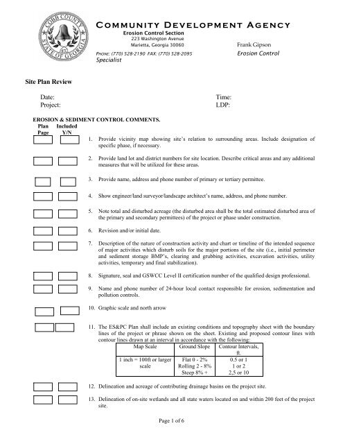
Community Development Agency<br />
<strong>Erosion</strong> <strong>Control</strong> Section<br />
223 Washington Avenue<br />
Marietta, Georgia 30060<br />
Frank Gipson<br />
PHONE: (770) 528-2190 FAX: (770) 528-2095<br />
Specialist<br />
<strong>Erosion</strong> <strong>Control</strong><br />
<strong>Site</strong> <strong>Plan</strong> Review<br />
Date:<br />
Project:<br />
Time:<br />
LDP:<br />
EROSION & SEDIMENT CONTROL COMMENTS.<br />
<strong>Plan</strong> Included<br />
Page Y/N<br />
1. Provide vicinity map showing site’s relation to surrounding areas. Include designation of<br />
specific phase, if necessary.<br />
2. Provide l<strong>and</strong> lot <strong>and</strong> district numbers for site location. Describe critical areas <strong>and</strong> any additional<br />
measures that will be utilized for these areas.<br />
3. Provide name, address <strong>and</strong> phone number of primary or tertiary permittee.<br />
4. Show engineer/l<strong>and</strong> surveyor/l<strong>and</strong>scape architect’s name, address, <strong>and</strong> phone number.<br />
5. Note total <strong>and</strong> disturbed acreage (the disturbed area shall be the total estimated disturbed area of<br />
the primary <strong>and</strong> secondary permittees) of the project or phase under construction.<br />
6. Revision <strong>and</strong>/or initial date.<br />
7. Description of the nature of construction activity <strong>and</strong> chart or timeline of the intended sequence<br />
of major activities which disturb soils for the major portions of the site (i.e., initial perimeter<br />
<strong>and</strong> sediment storage BMP’s, clearing <strong>and</strong> grubbing activities, excavation activities, utility<br />
activities, temporary <strong>and</strong> final stabilization).<br />
8. Signature, seal <strong>and</strong> GSWCC Level II certification number of the qualified design professional.<br />
9. Name <strong>and</strong> phone number of 24-hour local contact responsible for erosion, sedimentation <strong>and</strong><br />
pollution controls.<br />
10. Graphic scale <strong>and</strong> north arrow<br />
11. The ES&PC <strong>Plan</strong> shall include an existing conditions <strong>and</strong> topography sheet with the boundary<br />
lines of the project or phrase shown on the sheet. Existing <strong>and</strong> proposed contour lines with<br />
contour lines drawn at an interval in accordance with the following:<br />
Map Scale Ground Slope Contour Intervals,<br />
ft.<br />
1 inch = 100ft or larger<br />
scale<br />
Page 1 of 6<br />
Flat 0 - 2%<br />
Rolling 2 - 8%<br />
Steep 8% +<br />
0.5 or 1<br />
1 or 2<br />
2,5 or 10<br />
12. Delineation <strong>and</strong> acreage of contributing drainage basins on the project site.<br />
13. Delineation of on-site wetl<strong>and</strong>s <strong>and</strong> all state waters located on <strong>and</strong> within 200 feet of the project<br />
site.
<strong>Plan</strong><br />
Page<br />
Included<br />
Y/N<br />
14. Delineate sampling locations, perennial <strong>and</strong> intermittent streams <strong>and</strong> other water bodies into<br />
which storm water is discharged. Storm-drain pipe <strong>and</strong> weir velocities with appropriate outlet<br />
protection to accommodate discharges without erosion.<br />
15. Identify/Delineate all storm water discharge points.<br />
16. Indication that non-exempt activities shall not be conducted within the 25, 50, 75, 100 or 200-<br />
foot undisturbed stream buffers as measured from the point of wrested vegetation without first<br />
acquiring the necessary variances <strong>and</strong> permits.<br />
17. Delineate the undisturbed natural vegetative buffer(s) of 25-foot state buffer <strong>and</strong> 50’, 75’, 100’,<br />
<strong>and</strong> 200’ county buffer(s) <strong>and</strong> seven (7) mile water intake buffer in 1 st , 16 th 19 th <strong>and</strong> 20 th districts<br />
along with an additional 25 <strong>and</strong> 50-foot non-impervious buffer with a double row of Type-C Silt<br />
fence (sd1-C) installed to protect the buffer areas. Provide documentation to verify that a buffer<br />
variance from Georgia Environmental Protection Division (EPD) has been obtained for<br />
buffer encroachment. A letter of concurrence from Cobb County will also be required.<br />
Provide protective fencing along buffer(s) where contiguous to construction.<br />
18. If a TMDL Implementation <strong>Plan</strong> for sediment has been finalized for the Impaired Stream Segment<br />
(identified in item 18 above) at lease six months prior to submittal of NOI, the ES&PC <strong>Plan</strong> must<br />
address any site-specific conditions or requirements included in the TMDL Implementation <strong>Plan</strong>.<br />
19. All streams identified by the Georgia E.P.D. as an impaired stream from the 303 (d) or 305 (b) list<br />
any portion of an Biota Impaired Stream Segment must comply with Part III. C of the permit will<br />
require additional BMPs. This list of 20 required BMPs can be located in the GAR 1000001,<br />
GAR 1000002 <strong>and</strong> GAR 1000003 permits. Any project being developed within 1 mile of an<br />
impaired/impacted stream will require a minimum of 4 additional recommended BMPs to further<br />
decrease pollution to the streams.<br />
20. Determine outlet velocity at ____all outfalls_____. Exit velocities of 5 fps or greater from<br />
headwall require energy dissipation devices beyond the normal 6x diameter length of rip-rap.<br />
21. Please sign <strong>and</strong> date the following statement on plans: “ I certify that the permittee’s <strong>Erosion</strong><br />
<strong>Sedimentation</strong> <strong>and</strong> Pollution <strong>Control</strong> <strong>Plan</strong>, provides for an appropriate <strong>and</strong> comprehensive system<br />
of best management practices required by the Georgia Water Quality Act <strong>and</strong> the document<br />
“Manual for <strong>Erosion</strong> <strong>and</strong> Sediment <strong>Control</strong> in Georgia”, published by the State Soil <strong>and</strong> Water<br />
Conservation Commission as of January 1 of this year in which the l<strong>and</strong>-disturbing activity was<br />
permitted, provides for the sampling of the receiving water(s) or the sampling of the storm water<br />
outfalls <strong>and</strong> that the designed system of best management practices <strong>and</strong> sampling methods is<br />
expected to meet requirements contained in the General NPDES Permit Nos. GAR 1000001, GAR<br />
1000002, <strong>and</strong> GAR 1000003.” Include certification <strong>and</strong> signature in accordance with section<br />
V.G.d. of the permit.<br />
22. Please sign <strong>and</strong> date following statement on plans. “I CERTIFY UNDER PENALTY OF LAW<br />
THAT THIS PLAN WAS PREPARED AFTER A SITE VISIT TO THE LOCATION<br />
DESCRIBED HERE-IN BY MYSELF OR MY AUTHORIZED AGENT UNDER MY DIRECT<br />
SUPERVISION.”<br />
23. Please sign <strong>and</strong> date the following statement on plan: “THE PROPOSED EROSION AND<br />
RUNOFF CONTROL MEASURES ARE IN COMPLIANCE WITH THE COBB COUNTY<br />
SEDIMENT CONTROL AND FLOOD PROTECTION REGULATIONS AND WILL NOT<br />
INCREASE THE RUNOFF RATE FROM THE SITE FOR RAINSTORMS WITH A RETURN<br />
PERIOD OF 2, 5, 10, 25, 50 AND/OR 100 YEARS.<br />
Page 2 of 6
<strong>Plan</strong><br />
Page<br />
Included<br />
Y/N<br />
24. State on the plans how each individual lot will comply with erosion/sediment control measures<br />
(BMP’s) to prevent the escape of sediment from each lot. Provide details for each lot to have<br />
BMP’s installed (such as: silt fence, Co, Ds1, Temp. Sediment Basins, etc.) to prevent the escape<br />
of sediment for each situational lot. On steep slopes, show a temporary sediment basin at the<br />
downhill side <strong>and</strong> denote via flow areas for lot to be temporarily graded to flow into sediment<br />
basin. Address BMPs for all phases of common development including individual building lots<br />
<strong>and</strong> out-parcels, etc. regardless of who owns or operates the individual sites.<br />
25. Place matting/blanket at the following locations:<br />
26. Show a visible measuring post/stake/marking for clean out in detention ponds/ temporary<br />
sediment basin.<br />
27. Creek/Stream crossing: No full site LDP shall be issued until a copy of the nationwide permit<br />
(PCN) from the Corps of Engineers has been received. Please reference Nationwide Permit<br />
number 39.<br />
28. Specify sizes of rip-rap (St) at all outfalls.<br />
29. Indicate construction exit (Co) location on plan. Provide st<strong>and</strong>ard detail. Specify dimensions <strong>and</strong><br />
maintenance requirements on detail. Specify use of geotextile liner.<br />
30. The primary permittee must show a GPS location of the site construction exit.<br />
31. Specify use of type “C” (wire-backed) silt fence. Show st<strong>and</strong>ard detail. . All class “C” silt fence<br />
posts spacings should be 4’ on center. ( Show double row on all state water buffers.)<br />
32. Indicate temporary/permanent stabilization practices (Ds1, Ds2, Ds3) on plans. Include species,<br />
planting dates, seeding, fertilizer <strong>and</strong> mulching rates. Vegetative plan shall be site specific for<br />
appropriate time of year that seeding will take place <strong>and</strong> for the appropriate geographic region<br />
of Georgia.<br />
33. Provide retrofit (Rt) at outlet control structure(s) on detention pond.<br />
34. All projects 1 acre or more are required to have a Notice of Intent (NOI).<br />
35. A description of appropriate controls <strong>and</strong> measures that will be implemented at the construction<br />
site including: (1) initial sediment storage requirements <strong>and</strong> perimeter control BMPs, (2)<br />
intermediate grading <strong>and</strong> drainage BMPs <strong>and</strong> (3) final BMPs.<br />
36. BMPs for concrete washdown of tools, concrete mixer chutes, hoppers <strong>and</strong> the rear of the<br />
vehicles. Washout of the drum at the construction site is prohibited.<br />
37. Soil series <strong>and</strong> their delineation on phase I of the ESC plan.<br />
38. Limits of disturbance for each phase of construction.<br />
39. Provide a minimum of 67 cubic yards of sediment storage per acre drained using a temporary<br />
sediment basin, retrofitted detention pond, <strong>and</strong>/or excavated inlet sediment traps for each<br />
common drainage location. Sediment storage volume must be in place prior to <strong>and</strong> during all<br />
l<strong>and</strong> disturbance activities until final stabilization of the site has been achieved. A written<br />
rationale explaining the decision not to use a sediment basin must be included in the plan for<br />
each common drainage location in which a sediment basin is not provided. Worksheets from<br />
the Manual must be included for structural BMPs <strong>and</strong> all calculations used by the design<br />
professional to obtain the required sediment storage when using equivalent controls.<br />
Page 3 of 6
<strong>Plan</strong><br />
Page<br />
Included<br />
Y/N<br />
40. Location of Best Management Practices that are consistent with <strong>and</strong> no less stringent than the<br />
Manual for <strong>Erosion</strong> <strong>and</strong> Sediment <strong>Control</strong> in Georgia. Use uniform coding symbols from the<br />
Manual, Chapter 6, with legend.<br />
41. Best Management Practices to minimize off-site vehicle tracking of sediments <strong>and</strong> the<br />
generation of dust.<br />
42. <strong>Plan</strong> addresses BMP’s for all phases of common development including individual building lots<br />
<strong>and</strong> out-parcels, etc regardless of who owns or operates the individual sites. Include a typical<br />
<strong>and</strong> any situational lots applicable.<br />
43. Limit of disturbance shall be greater than 50 acres for each individual permittee (i.e. Primary,<br />
Secondary or Tertiary) at any one time <strong>and</strong> no more than 50 contiguous acres at one time without<br />
prior written authorization from the EPD District Office. If EPD approves the request to disturb<br />
50 acres or more at any one time, the <strong>Plan</strong> must include at least 4 of the BMPs listed in Appendix<br />
1 of this checklist.<br />
44. Use of alternative BMPs whose performance has been documented to be equivalent to or superior<br />
to conventional BMPs as certified by a Design Professional (unless disapproved by EPD or the<br />
Georgia Soil <strong>and</strong> Water Conservation Commission).<br />
45. Certification statement <strong>and</strong> signature of the permittee or the duly authorized representative as<br />
stated in section V.G.2.d. of the state general permit.<br />
46. Initial date of the <strong>Plan</strong> <strong>and</strong> the dates of any revisions made to the <strong>Plan</strong> including the entity who<br />
requested the revisions.<br />
NARRATIVE NOTES AND OTHER INFORMATION: (NOTES OR NARRATIVE SHOULD BE LOCATED ON THE ES&PC PLAN<br />
OR UNDER EROSION, SEDIMENTATION & POLLUTION CONTROL NOTES.):<br />
47. The following notes will be added to site plan:<br />
a. “<strong>Erosion</strong> control practices must comply with the minimum best management practices<br />
for erosion control. Cobb Co. Code Sect. 50-75, <strong>and</strong> shall comply with the<br />
st<strong>and</strong>ards/specifications in the Manual for <strong>Erosion</strong> <strong>and</strong> Sediment <strong>Control</strong> in Georgia”.<br />
b. In concentrated flow areas, all slopes steeper than 2.5:1 <strong>and</strong> with a height ten feet or<br />
greater, <strong>and</strong> cuts <strong>and</strong> fills within stream buffers, shall be stabilized with the appropriate<br />
erosion control matting or blanket.<br />
c. Mulch temporary vegetation on all exposed areas within 14 days after disturbance.<br />
d. Disturbed areas left idle for 5 days, <strong>and</strong> not to final grade, will be established to<br />
temporary vegetation (Ds2). All areas to final grade will be established to permanent<br />
vegetation (Ds3) immediately upon completion.<br />
e. When planting vegetation, mulch (hay or straw) should be uniformly spread over<br />
seeded area within 24 hours of seeding.<br />
f. Cobb County L<strong>and</strong> Disturbance Permit/Building Permits must be displayed on site at all<br />
times during construction <strong>and</strong> in plain view from a county road or street.<br />
g. <strong>Erosion</strong> <strong>and</strong> sediment control devices must be installed <strong>and</strong> inspected prior to any<br />
grading on site. Please call (770) 528-2134 with enough lead-time for an inspection to<br />
meet your schedule.<br />
Page 4 of 6
h. Sediment/erosion control devices must be checked after each storm event. Each device<br />
is to be maintained or replaced if sediment accumulation has reached one half the<br />
capacity of the device. Additional devices must be installed if new channels have<br />
developed.<br />
i. The use of polymers (PAMS) is accepted as a BMP as recommended by the STATE<br />
SOIL & WATER CONSERVATION COMMISSION BMP “green book”. Cobb<br />
County also requires that polymers used to stabilize construction sites must be used in<br />
conjunction with mulching <strong>and</strong> or hydro seeding.<br />
j. Additional erosion control devices to be used as required by Cobb County.<br />
k. If streams are on your site, Cobb County will require that the stream buffers be left<br />
undisturbed <strong>and</strong> a conservation easement or a restrictive covenant be placed on that<br />
property. For more information, please feel free to Dana Johnson with the <strong>Plan</strong>ning<br />
Division @ 770-528-2199 or Dana.Johnson@cobbcounty.org.<br />
l. Clearly note statement in bold letters - “The escape of sediment from the site shall<br />
be prevented by the installation of erosion <strong>and</strong> sediment control measures <strong>and</strong><br />
practices prior to, or concurrent with, l<strong>and</strong> disturbing activities.”<br />
m. Clearly note maintenance statement in bold letters - “<strong>Erosion</strong> control measures will<br />
be maintained at all times. If full implementation of the approved plan does not<br />
provide for effective erosion control, additional erosion <strong>and</strong> sediment control<br />
measures shall be implemented to control or treat the sediment source.”.<br />
n. Clearly note the statement in bold letters - “Any disturbed area left exposed for a<br />
period greater than 14 days shall be stabilized with mulch or temporary<br />
seeding.”.<br />
48. Provide detailed drawings for all structural practices. Specifications must, at a minimum, meet<br />
the guidelines set forth in the Manual for <strong>Erosion</strong> <strong>and</strong> Sediment <strong>Control</strong> in Georgia. Provide<br />
st<strong>and</strong>ard detail(s) for _______________________.<br />
49. <strong>Plan</strong> describes practices used to reduce the pollutants in storm water discharges.<br />
CLEARLY NOTE THE FOLLOWING STATEMENTS IN BOLD LETTERS:<br />
50. Indication that the applicable portion of ES&PC <strong>Plan</strong> is to be provided to each secondary<br />
permittee prior to the secondary conducting any construction activity <strong>and</strong> that each secondary<br />
shall sign the <strong>Plan</strong> or portion of the <strong>Plan</strong> applicable to their site. List the names <strong>and</strong> addresses<br />
of all secondary permittees.<br />
51. Indication that the design professional who prepared the ES&PC <strong>Plan</strong> is to inspect the<br />
installation of BMP’s within 7 days after initial construction activity begins.<br />
52. Indication that amendments/revisions to the ES&PC <strong>Plan</strong> which have a significant effect on<br />
BMP’s with a hydraulic component must be certified by the design professional.<br />
53. Indication that waste materials shall not be discharged to waters of the State, except as<br />
authorized by a Section 404 permit.<br />
54. Documentation that the ES&PC <strong>Plan</strong> is in compliance with waste disposal, sanitary sewer, or<br />
septic tank regulations during <strong>and</strong> after construction activities have been completed.<br />
55. Details on required inspections <strong>and</strong> record keeping by the primary permittee, secondary<br />
permittees <strong>and</strong> tertiary permittees. Provide complete details for retention of records as per<br />
Page 5 of 6
56. Description of analytical methods to be used to collect <strong>and</strong> analyze the samples from each<br />
location.<br />
57. Information on sampling frequency <strong>and</strong> reporting requirements. (Please use Appendix B from<br />
the General Permit for rationale for outfall sampling points where applicable.)<br />
58. Provide hydrology study <strong>and</strong> maps of drainage basins for both the pre- <strong>and</strong> post-developed<br />
conditions.<br />
59. An estimate of the runoff coefficient or peak discharge flow of the site prior to <strong>and</strong> after<br />
construction activities are completed.<br />
60. Description of the measures that will be installed during the construction process to control<br />
pollutants in storm water that will occur after construction operations have been completed.<br />
61. The applicable <strong>Erosion</strong>, <strong>Sedimentation</strong> <strong>and</strong> Pollution <strong>Control</strong> <strong>Plan</strong> Checklist established by the<br />
Commission as of January 1 of the year in which the l<strong>and</strong> disturbing activity was permitted.<br />
62. Identify the project receiving waters <strong>and</strong> describe all adjacent areas including streams, lakes,<br />
residential areas, wetl<strong>and</strong>s, etc. which may be affected.<br />
63. BMP’s for the remediation of all petroleum spills <strong>and</strong> leaks.<br />
*Eligible for One-Stop.<br />
FLG/JJ<br />
Rev. 02/09/09<br />
Page 6 of 6