III. Existing Conditions - Community Development - Cobb County
III. Existing Conditions - Community Development - Cobb County
III. Existing Conditions - Community Development - Cobb County

You also want an ePaper? Increase the reach of your titles
YUMPU automatically turns print PDFs into web optimized ePapers that Google loves.
Powers Ferry Master Plan<br />
<strong>III</strong>. <strong>Existing</strong> <strong>Conditions</strong><br />
The purpose of this section is to document the existing conditions of the study area,<br />
including a review of other planning documents associated with this area of the county<br />
demographics, land use patterns, transportation networks, housing, crime, community<br />
facilities, parks and open space and undeveloped land. The existing conditions analysis is<br />
intended to provide a snapshot of what the Powers Ferry corridor is today. Data collected<br />
from a variety of sources provides the foundation and illustrates the point from which our<br />
planning efforts begin.<br />
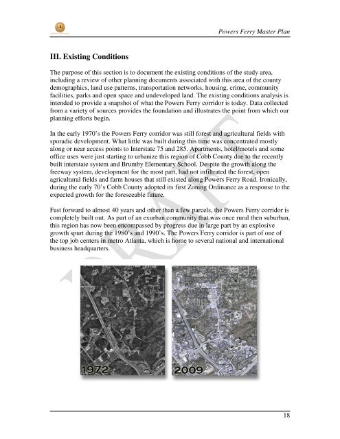
In the early 1970’s the Powers Ferry corridor was still forest and agricultural fields with<br />
sporadic development. What little was built during this time was concentrated mostly<br />
along or near access points to Interstate 75 and 285. Apartments, hotel/motels and some<br />
office uses were just starting to urbanize this region of <strong>Cobb</strong> <strong>County</strong> due to the recently<br />
built interstate system and Brumby Elementary School. Despite the growth along the<br />
freeway system, development for the most part, had not infiltrated the forest, open<br />
agricultural fields and farm houses that still existed along Powers Ferry Road. Ironically,<br />
during the early 70’s <strong>Cobb</strong> <strong>County</strong> adopted its first Zoning Ordinance as a response to the<br />
expected growth for the foreseeable future.<br />
Fast forward to almost 40 years and other than a few parcels, the Powers Ferry corridor is<br />
completely built out. As part of an exurban community that was once rural then suburban,<br />
this region has now been encompassed by progress due in large part by an explosive<br />
growth spurt during the 1980’s and 1990’s. The Powers Ferry corridor is part of one of<br />
the top job centers in metro Atlanta, which is home to several national and international<br />
business headquarters.<br />
18
Powers Ferry Master Plan<br />
<strong>III</strong>.A Previous Planning Studies & Peer <strong>Community</strong> Review<br />
Different sections of the Powers Ferry Master Plan have been the subject of numerous<br />
planning studies over the last 10 years. In addition to the <strong>County</strong>’s overall 2030<br />
Comprehensive Plan and Comprehensive Transportation Plan (CTP), most of the subarea<br />
plans were conducted by the Cumberland CID and concentrated in the southern tier<br />
of the study boundary. The northern part of the study area has garnered less attention but<br />
was incorporated into planning initiatives conducted in a joint effort by the City of<br />
Marietta and <strong>Cobb</strong> <strong>County</strong>. The purpose of this master planning effort is not to replicate<br />
prior studies, but to instead build upon them and provide the community with a policy<br />
manual to guide future development and redevelopment within the Powers Ferry corridor.<br />
Previous Planning Studies<br />
These earlier studies have provided important insights into the desires of the community<br />
and have influenced planning recommendations within this Master Plan. These studies<br />
and reports include the following:<br />
Comprehensive Plans<br />
<strong>Cobb</strong> <strong>County</strong> 2030 Comprehensive Plan<br />
The 2030 Comprehensive Plan is a policy document<br />
that assists decision-making and administrative<br />
actions in an effort to guide <strong>Cobb</strong> <strong>County</strong> as whole<br />
towards the community’s preferred future. It<br />
includes Character Areas, Future Land Use Map,<br />
Policies and an Implementation Program to achieve<br />
the goals.<br />
The Character Areas and Future Land Use Map will<br />
be mentioned later in this document. The Policies<br />
provide the framework for moving the <strong>County</strong> into<br />
the next 30 years. There are multiple policies<br />
identified in the <strong>County</strong>’s Comprehensive Plan that<br />
are essential to the development of this plan. Below<br />
are just a few that are highlighted.<br />
Policy 1.2 - Increase the economic vitality of underserved areas through programs<br />
and incentives<br />
Policy 1.17 – Identify blighted and deteriorating neighborhoods and promote the<br />
revitalization and/or redevelopment of these areas.<br />
19
Powers Ferry Master Plan<br />
Policy 1.18 – Promote smart growth policies and encourage the creative design of<br />
residential developments that meet the needs of the human and natural<br />
environment.<br />
Policy 2.3 - Encourage adequate amounts, types, and densities of housing needed<br />
to support desired commercial and industrial growth.<br />
Policy 2.14 - Promote the construction of mixed-use developments in appropriate<br />
areas.<br />
Policy 2.15 – Promote the creation of community gathering spaces.<br />
Policy 3.1 - Work with various organizations to market <strong>Cobb</strong> <strong>County</strong>'s strengths<br />
and its quality of life, in order to attract new businesses and retain existing<br />
businesses.<br />
Policy 4.6 - Promote revitalization or redevelopment of declining residential areas<br />
through economic incentives, code changes, and/or land use changes.<br />
Policy 4.11 - Collaborate with the <strong>Cobb</strong> <strong>County</strong> Schools to improve non-vehicular<br />
travel in areas surrounding schools.<br />
Policy 4.14 - Sustain partnerships between local school system administrative<br />
staffs and county staff regarding education and population growth issues.<br />
Policy 6.6 - Encourage the development of multi-use greenways in flood plains<br />
and easements to allow for the maintenance of natural open space while<br />
accommodating citizens needs for passive recreation opportunities, bicycle<br />
networks, and public access to lakes and streams for low intensity recreation.<br />
Policy 7.6 - Promote transportation alternatives such as transit, bicycle facilities,<br />
pedestrian infrastructure, car pooling, and other forms of alternative modes of<br />
travel.<br />
Policy 7.10 – Promote land use transportation linkages to ensure an adequate<br />
transportation system for anticipated future populations and their corresponding<br />
travel behaviors.<br />
Policy 9.6 - Promote home ownership initiatives as a means to build community<br />
support, pride, and expand housing choices for individuals.<br />
Policy 10.1 - Encourage diverse citizen participation in transportation and land<br />
use planning processes.<br />
20
Powers Ferry Master Plan<br />
<strong>Cobb</strong> <strong>County</strong> Comprehensive Transportation Plan (CTP)<br />
The CTP serves as the strategy for transportation investments over the next 25 years. It is<br />
a long-range, comprehensive plan that is multimodal in nature and integrally linked to the<br />
land use plan developed by the <strong>County</strong> and its incorporated neighbors. The CTP includes<br />
recommended projects and policies for the entire <strong>County</strong> to be implemented over the<br />
lifetime of the CTP. The Programmed and Recommendation improvements below pertain<br />
to projects listed within the Powers Ferry Study area.<br />
Recommended from CTP<br />
Roadway Capacity Improvements<br />
Delk Road – <strong>Cobb</strong> Parkway to Powers Ferry Road – Widen to 6 – 8 lanes.<br />
Transit<br />
Circulator shuttles in Cumberland/Galleria<br />
Multi Use Trails<br />
Rottenwood Creek Trail – Bob Callan Trail Phase II<br />
Programmed from CTP<br />
Roadway Capacity Improvements<br />
Delk Road – I-75 to Powers Ferry Road – Widen 6 lane divided<br />
Powers Ferry Road – Delk Road to Terrell Mill Road – Widen 6 lane divided<br />
Leland Drive Extension – Northern terminus to Terrell Mill Road – New 2 land<br />
roadway<br />
Operational Intersection Improvements<br />
Windy Hill Road at I-75 – Congestion relief intersection improvements<br />
Windy Hill Road (EB) at Powers Ferry Road (NB) – Congestion relief<br />
Sub-Area Plans<br />
Franklin/Delk Livable Centers Initiative (LCI) Study and 5 year update<br />
The Delk Transit Oriented <strong>Development</strong> (TOD) LCI study was a joint planning<br />
collaboration between the City of Marietta and <strong>Cobb</strong> <strong>County</strong> that was approved in early<br />
2005. The purpose for the study was to determine if the previously proposed I-75 Bus<br />
Rapid Transit (BRT) station that was planned for the Delk Road area can stimulate<br />
revitalization surrounding the station. Since the study was approved, the proposed BRT<br />
transit system plans have been shelved indefinitely, because it was never approved by the<br />
Federal Transit Authority due to differences in data results, and have substantially altered<br />
the initial goals and objectives of the original plan. Consequently, the City of Marietta<br />
has completed a 5 year update to the plan that is now known as the Franklin/Delk LCI<br />
Study, thus repositioning and revising the vision, goals and initiatives for the community.<br />
This revision removes the redevelopment focus of the BRT line and develops scenarios<br />
based upon recruitment of green technology industries. The Powers Ferry Master Plan<br />
will serve as the update and re-imagination for the unincorporated portion of the<br />
Franklin/Delk LCI.<br />
21
Powers Ferry Master Plan<br />
Below are new local initiatives that are listed in the LCI study as under development.<br />
Global Green Technology Corridor – Is an innovative effort utilizing renewable<br />
energy technologies to revitalize the Franklin Road corridor by taking advantage<br />
of existing businesses and higher learning institutions in the area. This serves as a<br />
focal point of the Marietta portion of the updated Franklin/Delk LCI.<br />
Opportunity Zones – Is a Job Tax Credit initiative offered by the Georgia<br />
Department of <strong>Community</strong> Affairs to Local Governments which undertake<br />
redevelopment and revitalization efforts that are in decline, suffer from<br />
disinvestment and are in need of redevelopment and revitalization. To be eligible<br />
for the tax credit program, the Opportunity Zone must be contained within block<br />
groups with a poverty rate of 15% or block groups that are adjacent to block<br />
groups with a poverty rate of 15% or greater.<br />
If areas meet criteria for designation they will qualify for the following incentives:<br />
Maximum state Job Tax Credit of $3,500 per newly created job, the lowest job<br />
creation threshold (2 jobs) of any tax credit program, and the use of Job Tax<br />
Credit against 100% of income tax liability and payroll withholding.<br />
New Market Tax Credits (NMTC)– The purpose of the program is to increase<br />
investment capital available to business and economic development programs in<br />
low-income communities and areas that have poor access to debt and equity<br />
capital. Each year, the NMTC program offers a seven-year, 39 percent federal tax<br />
credit for Qualified Equity Investments (QEI) made through investment vehicles<br />
known as <strong>Community</strong> <strong>Development</strong> Entities (CDE).<br />
Other Transportation initiatives within the Franklin/Delk LCI pertinent to the Powers<br />
Ferry Master Plan are listed below:<br />
Delk Road Medians: from I-75 to Powers Ferry Road<br />
Rottenwood Creek Multi-use Trail Phase 1: from Terrell Mill to I-75<br />
Powers Ferry Road Multi-use Trail: from South Marietta Parkway (SR 120) to<br />
Terrell Mill Road<br />
Delk Road at Powers Ferry Road Pedestrian Signal Upgrades<br />
Delk Road at Powers Ferry Road intersection improvements<br />
22
Powers Ferry Master Plan<br />
Northeast Corridor Transportation Plan<br />
The Northeast Corridor Transportation Master Plan was an action plan that<br />
comprehensively addressed commercial and residential mobility and accessibility needs<br />
within the northeast corridor of the Cumberland CID. The following recommendations<br />
are included below:<br />
Land Use<br />
The plan recommends transit-based town center type areas along Powers Ferry<br />
Road, including Powers Ferry Road at Terrell Mill Road, with an emphasis on a<br />
concentration of commercial uses in a well-defined area at the core, mixing uses<br />
within a single site and building, reducing building setbacks, concealing surface<br />
parking, providing on-street parking and improving pedestrian connections.<br />
New redevelopment efforts should focus on the older, multi-family residential<br />
uses and include a mix of owner and rental units for the older apartment<br />
complexes.<br />
Conversion of commercial property to residential is the recommended scenario<br />
for the commercial uses on the east side of Powers Ferry, south of Windy Hill<br />
Road.<br />
Small Lot Single-Family housing is recommended, specifically within portions of<br />
Wildwood.<br />
Transfer of <strong>Development</strong> Rights was mentioned in the Northeast Corridor<br />
Transportation Plan as way to preserve open space and promote higher densities<br />
in desirable locations within the CID<br />
Transportation<br />
High-priority projects<br />
Terrell Mill realignment at Delk Road<br />
Terrell Mill Road at Paper Mill Road intersection improvements<br />
Terrell Mill Road at Lower Roswell Road intersection improvments<br />
Lower Roswell Road at Old Canton Road<br />
Short-term projects<br />
Powers Ferry Road at Delk Road intersection improvements<br />
Powers Ferry Road at Interstate North Parkway<br />
Long-term projects<br />
Powers Ferry Road improvements from Terrell Mill Road to Delk Road<br />
Grade separation at Wildwood Parkway to the I-75 interchange with Windy Hill<br />
Road (to be planned as part of the Windy Hill Road at I-75 interchange<br />
improvement project)<br />
23
Powers Ferry Master Plan<br />
Blueprint Cumberland Strategic Plan<br />
The Blueprint Cumberland Strategic Plan, more commonly known as Blueprint<br />
Cumberland, is a Cumberland LCI Plan sponsored by The Atlanta Regional Commission,<br />
The Cumberland <strong>Community</strong> Improvement District (CID) and the Cumberland<br />
Transportation Network (CTN). Blueprint Cumberland provides a framework and<br />
roadmap for urbanizing the core of the Cumberland area into a more livable, walkable,<br />
sustainable and aesthetically pleasing environment and includes urban design standards<br />
and streetscape options.<br />
The primary focus of the plan is concentrated in the core of the CID. However, parts of<br />
the CID that stretch up and into the Powers Ferry Corridor are represented within the<br />
Blueprint Cumberland Study Area. The study area is the subject of detailed<br />
recommendations for future land use and possible rezoning recommendations through the<br />
Supplemental Housing Study conducted in 2003.<br />
Through the Supplemental Housing Study, development opportunities and design<br />
standards were set to help create a better balance between jobs and housing, and shift the<br />
focus to allowing redevelopment of rental apartments to a mix of for-sale and rental<br />
housing.<br />
Blueprint Cumberland II<br />
Blueprint Cumberland II is an extension of the Blueprint Cumberland Strategic Plan in<br />
2001 and the Supplemental Housing Study conducted in 2003. The intent of Blueprint<br />
Cumberland II is to update the original plan and formulate new goals based on current<br />
conditions and market trends and develop a strategic plan to address the reformulated<br />
goals.<br />
Due to the diverse geographic area within the Blueprint II planning boundaries, the area<br />
was separated into “Areas of Influence” and the “Core Area”. The envisioned heart of the<br />
CCID is the “Core Area”, which is the subject of detailed analysis and is influenced the<br />
most by the plans recommendations. The “Core Area” does not extend into the Powers<br />
Ferry Master Plan study boundary. As way to provide a voice for adjacent stakeholders<br />
that will be affected by the plan the most an “Area of Influence” was established. This<br />
area represents the broadest geographic area of the study and overlaps the southern<br />
portion of the Powers Ferry Master Plan study area south of Windy Hill Road.<br />
After conceptualizing three master plan scenarios a recommended Master Plan,<br />
concentrated within the Core Area of the Plan, was developed. Some of the key<br />
recommendations from the Blueprint Cumberland II plan include:<br />
Focal Point within Core Area<br />
Mixed-Use districts throughout sub-areas as defined by the plan<br />
24
Powers Ferry Master Plan<br />
Additional vehicular and pedestrian connections within the area<br />
Offer other transportation choices and incorporate traffic initiatives to provide a<br />
safer pedestrian environment (i.e. traffic calming measures, landscaped medians,<br />
paved intersections and improved crosswalks)<br />
Other key recommendations from the plan that represent issues that will remain a<br />
continued concern to the CCID include:<br />
Expanding Blueprint Cumberland II to cover area outside of the Core Area and<br />
within the CCID boundaries<br />
A joint planning study with the City of Sandy Springs and the Fulton Perimeter<br />
CID, as an expansion of Blueprint Cumberland II, to determine the long-term<br />
transportation needs<br />
To facilitate greater mobility for pedestrians, create a Pedestrian Mobility Action<br />
Plan<br />
Establishing a physical identity for the Cumberland/Galleria community<br />
As large parcels are redeveloped, promote the creation of street grids for<br />
improved mobility<br />
Create transit service within CCID<br />
Promote development and redevelopment of mixed-use and residential housing to<br />
improve the jobs-to-housing balance<br />
Peer Communities Review<br />
As part of the process of developing the Powers Ferry Master Plan, <strong>Community</strong><br />
<strong>Development</strong> Planning Division staff reviewed planning documents from local, regional,<br />
and national communities, which are similar in nature to the Powers Ferry area and area<br />
facing similar issues. The purpose of these “peer community” reviews is to determine the<br />
most successful and least successful tools that can be used to assist with redevelopment.<br />
The three communities chosen for review include: the Perimeter CID in metropolitan<br />
Atlanta, Tysons Corner in Fairfax <strong>County</strong>, VA (in suburban Washington DC); and the<br />
City of Fort Lauderdale, FL (in the Miami metropolitan area).<br />
Perimeter CID<br />
The Perimeter CID in Fulton and DeKalb <strong>County</strong>, GA is a successful satellite city much<br />
like the Cumberland CID. This area is a regional employment, retail, and service hub<br />
25
Powers Ferry Master Plan<br />
with a high concentration of professional office and medical uses. The area has high<br />
density residential uses at the core of the community that transitions to lower density<br />
residential communities such as Dunwoody and Sandy Springs at the periphery. One of<br />
the major differences between the areas is the presence of MARTA transit system which<br />
provides heavy rail mass transportation solutions to connect the Perimeter area with<br />
Buckhead, Midtown, and Downtown Atlanta. Another major difference is in funding.<br />
The Perimeter CID, much like the Cumberland CID can leverage funds to assist with the<br />
implementation of transportation alternatives and solutions to assist the area’s growth.<br />
These funds will not be able to be leveraged in the Powers Ferry area that is out of the<br />
CID boundary.<br />
The Perimeter CID is a good example to use because they have recently updated their<br />
LCI study which will provide a reliable resource for determining successful tools that<br />
they have implemented to assist in creating change in this area. Some of the successful<br />
solutions dealing with the core area and the transitions areas are as follows:<br />
• Shuttle circulator service for residents, shoppers, and employers in the area to<br />
connect MARTA rail station with surrounding uses;<br />
• Streetscape Improvements along major corridors;<br />
• Intersection improvements to improve traffic mobility;<br />
• Flyover bridge to assist with north-south connectivity;<br />
• Creating new streets to formulate a grid system as part of the redevelopment of<br />
large parcels;<br />
• Pedestrian connections at the Perimeter Mall;<br />
• Sidewalk installations;<br />
• On street bike lanes;<br />
• Off street bicycle & pedestrian facilities;<br />
• Open space protection and new park creation; and<br />
• Zoning Overlay District between Fulton and DeKalb <strong>County</strong> to merge<br />
development opportunities and create the same rules regardless of jurisdiction.<br />
Tysons Corner<br />
Tysons Corner is very similar to the Cumberland Area in that represents a shift in growth<br />
patterns over the last forty years that saw a shift from the traditional downtown expansion<br />
growth model of office and retail into more of the satellite city model. Many of these<br />
satellite cities were created at major transportation crossroads that supplied large volumes<br />
of traffic and provided convenient locations for new commercial ventures. These satellite<br />
cities are now maturing and are becoming more and more urban over time. They bring an<br />
urban environment out to their suburban area taking on more of the personality of their<br />
metropolitan hubs. Like the Perimeter CID, Tysons Corner is connected to regional rail<br />
mass transit, which assists with connecting it to the workforce and activity centers of the<br />
larger Washington DC region. Also, Tysons Corner, much like the Cumberland and<br />
Perimeter CIDs, can leverage funds to assist with the implementation of transportation<br />
26
Powers Ferry Master Plan<br />
alternatives and solutions to assist the area’s growth. These funds will not be able to be<br />
leveraged in the Powers Ferry area that is out of the CID boundary.<br />
The Tysons Corner Plan “Transforming Tysons” is a master planning document that<br />
provides for more urban type development around its four rail transit stops with a<br />
transitioning of land uses and transportation options around its periphery. Some of the<br />
recommendations from these transition areas include the following:<br />
• Additional public facilities to meet the needs of the growing residential<br />
community;<br />
• Increased FAR for transitioning/underutilized retail areas with additional height<br />
limitations to provide the scale necessary for redevelopment without negatively<br />
impacting surrounding residential property owners;<br />
• Circulator service to provide another form of transportation alternatives;<br />
• Leverage redevelopment of properties to secure ROW for transportation<br />
improvements when increased density or FAR is allowed;<br />
• Encourage parcel consolidation as part of redevelopment to assist in mproving<br />
transportation mobility while increasing intensity;<br />
• Increased density at existing deteriorating apartment communities by increasing<br />
densities from 8-12 units per acre to 20-30 units per acre;<br />
• Protect neighboring stable residential uses through the use of screening, landscape<br />
buffers, improved building design, noise attenuation, and building height<br />
transitions;<br />
• <strong>Development</strong> of a Building Height Concept scenario that provides<br />
recommendations on building heights in different areas of Tysons Corner;<br />
• <strong>Development</strong> of a Tiered Intensity Concept that provides recommendations on<br />
FAR in different areas of Tysons Corner;<br />
• <strong>Development</strong> of street type guidelines depending on the type of street and<br />
function of the street;<br />
• Develop a Zoning Overlay District that is distinct to Tysons Corner;<br />
• Develop urban development, infrastructure, and standards to assist in building an<br />
urban environment that is different from the general suburban standards required<br />
in other areas of Fairfax <strong>County</strong> while also balancing the needs of transit,<br />
walking, bikes, and cars;<br />
• Create design guidelines that recognize the difference of each district within<br />
Tysons Corner so that it does not become homogenous through the use of<br />
Character Zones; and<br />
• Requirement for transportation studies with all new developments to assist in<br />
improving mobility in the corridor.<br />
27
Powers Ferry Master Plan<br />
City of Fort Lauderdale, FL<br />
The City of Fort Lauderdale, FL is a urban/suburban area in metropolitan Miami. They<br />
have recently conducted a Urban Design Plan for North US 1. The plan was created due<br />
to the changing nature of the corridor from a suburban commercial oriented high-speed<br />
arterial to an urban street with a mixture of uses that needs to meet the needs of a variety<br />
of functions. The plan separates the roadway into a variety of nodal points and<br />
determines the appropriate building threshold for each of the sub-markets. It then<br />
established circulation patterns, site standards, character areas, design guidelines, and<br />
develops an implementation plan to bring it all to fruition. The implementation plan<br />
contains the following:<br />
• Adopt new zoning code to enforce design guidelines;<br />
• Adjust zoning code and comprehensive plan to add additional commercial depth<br />
to commercial corridors to assist with redevelopment;<br />
• Develop improved transit options;<br />
• Increase pedestrian infrastructure and expand right-of-way;<br />
• Define signage, landscaping, and architectural requirements for character areas;<br />
• Develop specific plans for unique sites or intersections;<br />
• Develop on-site cross access easements;<br />
• Consider a Interdistrict Corridor Maintenance Program; and<br />
• Develop tax incentives for improvements on existing properties.<br />
<strong>III</strong>.B Demographics<br />
Population<br />
Population estimates as well as projections were collected over a 3 mile radius from the<br />
intersection of Terrell Mill Road and Powers Ferry Road. The 3 mile radius includes the<br />
entire study area and roughly a mile outside the study area. Parts of the containment area<br />
include Fulton <strong>County</strong> and the City of Atlanta.<br />
Claritas, a market research firm, provided the population figures and shows that<br />
according to the 1990 Census there were 63,460 people inside the 3 mile ring. By 2000<br />
the population had grown to 74,355 and in 2009 it is estimated that 75,646 people reside<br />
in the area. Over the next 5 years to 2014, according to Claritas the population will grow<br />
to 77,701.<br />
Population<br />
0-3 miles<br />
1990 63,460<br />
2000 74,355<br />
2009 Estimate 75,646<br />
2014 Projection 77,701<br />
Figure 6<br />
28
Powers Ferry Master Plan<br />
Most of the growth inside the 3 mile radius occurred between 1990 and 2000. The<br />
population during that 10 year span grew by 17%. However, in almost the same time<br />
frame from 2000 to 2009 the population growth slowed to only 1.74%. Over the next 5<br />
years growth within the Powers Ferry corridor area is expected to eclipse the last 9 years<br />
with a projected growth of 2.72%.<br />
Population Growth<br />
0-3 miles<br />
Growth 1990-2000 2.72%<br />
Estimated Growth 2000-2009 1.74%<br />
Projected Growth 2009-2014 2.72%<br />
Figure 7<br />
Race & Ethnicity<br />
The Powers Ferry Road community has been known to be one of the more diverse areas<br />
of <strong>Cobb</strong> <strong>County</strong>. Based on the 2009 estimates from Claritas, the race make up of the<br />
Powers Ferry area, when compared to <strong>Cobb</strong> <strong>County</strong>, shows the diversity of the region.<br />
The majority of the demographic study area population is 52% white compared to the<br />
county’s 68% of the same race. Blacks or African Americans make up 29% of the<br />
population, while they only represent 26% of the county. The most significant finding<br />
was the 16.6 % Latino within the 3 mile radius compared to the county’s 12%. The fact<br />
that there are fewer whites and more minority groups representing the population shows<br />
there is a level of multiculturalism going on within the area.<br />
A large part of the Latino community in the Powers Ferry area is Brazilian. According to<br />
the Global Atlanta Snapshots publication put out by the Atlanta Regional Commission<br />
(ARC), <strong>Cobb</strong> <strong>County</strong> is home to the largest population of Brazilians, with 1,813 (2000<br />
Census Data on Foreign-Born Population by Region, Country or Area of Birth). Of the<br />
1,813 the majority reside in census tracts 304.06, 304.05 and 303.21, which overlaps the<br />
Powers Ferry Study Area.<br />
29
Powers Ferry Master Plan<br />
80.0%<br />
Race & Ethnicity<br />
70.0%<br />
60.0%<br />
50.0%<br />
Powers Ferry<br />
<strong>Cobb</strong> <strong>County</strong><br />
40.0%<br />
30.0%<br />
20.0%<br />
10.0%<br />
0.0%<br />
White alone<br />
Black or African American<br />
alone<br />
Hispanic or Latino<br />
Figure 8<br />
Age<br />
One of the more important dimensions of the population as it relates to servicing needs of<br />
the community is age of the population. Figure 9 breaks down the population by age<br />
groups and shows that the majority are in the prime of there life between 25 and 45 years<br />
of age. When compared to the county, the Powers Ferry area has a much larger share of a<br />
younger population, with fewer children and less “baby boomers” and elderly. This can<br />
be partly contribute to the the area’s location within a more urban environment, which is<br />
a more desirable development pattern for younger individuals.<br />
Share of Population<br />
25.0%<br />
20.0%<br />
15.0%<br />
10.0%<br />
5.0%<br />
Population by Age<br />
<strong>Cobb</strong> <strong>County</strong><br />
Pow ers Ferry<br />
0.0%<br />
Under 5 years<br />
5 to 9 years<br />
10 to 14 years<br />
15 to 19 years<br />
20 to 24 years<br />
25 to 34 years<br />
35 to 44 years<br />
45 to 49 years<br />
Age Groups<br />
Figure 9<br />
50 to 54 years<br />
55 to 59 years<br />
60 to 64 years<br />
65 to 74 years<br />
75 to 84 years<br />
Age 85 and Older<br />
30
Powers Ferry Master Plan<br />
<strong>III</strong>.C Land Use<br />
Character Areas<br />
The Powers Ferry study area contains really three distinct character areas according to the<br />
Character Area Map within the 2030 Comprehensive Plan. Most of the northwestern part<br />
of the study area is considered Suburban Residential due to the mostly residential uses in<br />
the area. The commercial activity node along Powers Ferry between Delk Road and<br />
Wildwood Parkway has been identified as a corridor character because of the “strip”<br />
nature of the commercial activity. Approximately three quarters of the southern part of<br />
the study area is considered Urban Center on the Character Area map. These areas<br />
contain a concentration of high intensity office and commercial uses.<br />
<strong>Existing</strong> Land Use<br />
According to Figure 10, just over half of the existing land use (51.3%) is residential and<br />
can be found almost exclusively within the northern two thirds of the study area. The<br />
most prevalent type of residential is multi-family followed by attached townhome<br />
communities and a very small area of single family detached housing. The 2 nd most<br />
dominant use is commercial which makes up 40% of the existing uses. Most of the<br />
commercial can be found in the southern portion of the study area and along both sides of<br />
Powers Ferry Road. The most common type of commercial is office which is<br />
concentrated mostly south of Windy Hill Road between Powers Ferry and I-75. Retail is<br />
the 2 nd most dominant type of existing commercial use and makes up most of the uses<br />
along both sides of Powers Ferry Road. Some less frequent uses are civic/government<br />
institutions or utility uses. There are still pockets of undeveloped lands, primarily in the<br />
southern section of the corridor, with the exception of a large contiguous area of county<br />
owned open space adjacent to I-75 on the south side of Terrell Mill Road.<br />
1.2%<br />
0.1%<br />
1.3% 6.1%<br />
<strong>Existing</strong> Land Use<br />
Residential<br />
Commercial<br />
40.0%<br />
51.3%<br />
Civic<br />
Transportation/Communication/Utilities<br />
Park/Recreation/Conservation<br />
Undeveloped<br />
Figure 10<br />
31
Powers Ferry Master Plan<br />
Future Land Use<br />
The 2030 <strong>Cobb</strong> <strong>County</strong> Comprehensive Plan is a general guide and policy document that<br />
includes desired future land uses to assist planning decisions within the community. The<br />
future land use section of the comprehensive plan defines a broad spectrum of future uses<br />
and includes guidelines and allowable zonings within each Future Land Use designation.<br />
The most prevalent future land use in the corridor is the Regional Activity Center (RAC),<br />
which makes up most of the southern half of the entire study area, according to Figure<br />
11. The purpose of the Regional Activity Center is to provide for areas that can support a<br />
high intensity of development, which serves a regional market. Typical uses include high<br />
rise offices, urban commercial and dense residential development, all of which can<br />
currently be found within this area of <strong>Cobb</strong> <strong>County</strong>.<br />
32
Powers Ferry Master Plan<br />
Figure 11<br />
33
Powers Ferry Master Plan<br />
In 1994 the Board adopted Sub-area classifications to the RAC (Figure 12) with the<br />
intent to optimize the use of land and encourage development in the most appropriate<br />
locations, which were determined by several factors, such as carrying capacity, access<br />
considerations, compatibility with adjacent uses and suitability to scale and market<br />
potential. The sub area classifications are intentionally broad to provide flexibility for<br />
growth within the RAC.<br />
Figure 12<br />
34
Powers Ferry Master Plan<br />
The next most notable future use is High Density Residential (HDR). Approximately<br />
31% of the future land uses within the study boundary is marked for a higher dense<br />
housing product. Along Bentley Road north of Terrell Mill Road and south of Delk Road<br />
contains the highest concentration of HDR properties, which provides for residential uses<br />
between 5 and 12 units per acre.<br />
<strong>Community</strong> Activity Center (CAC), which stretches along Powers Ferry Road on both<br />
sides of the roadway and along Windy Hill Road, makes up about 11% of the future land<br />
use in the Powers Ferry community. The CAC provides for areas that can meet the needs<br />
of several neighborhoods or communities. It is less intense than the RAC and does not<br />
include the sub-categories or the flexibility of the RAC. Some of the typical land uses<br />
suggested within the CAC include low to medium intensity office, retail and commercial<br />
services. There is a limit to building heights and, the floor area ratios for both office and<br />
retail are significantly less than the RAC.<br />
Some of the other less frequent future use designations but just as important is Medium<br />
Density Residential (MDR), which can be found at the northeast corner of Delk Road and<br />
Powers Ferry Road. The Very Low Density Residential (VLDR) designation on the east<br />
side of Powers Ferry road between Terrell Mill and Wildwood Parkway is an unusual<br />
future land use category within such an urban environment. A small pocket of Low<br />
Density Residential (LDR) can be found on the corner of Delk Road and Terrell Mill<br />
Road and Public Institutional (PI) which provides for government and institutional uses,<br />
can be found at the current location of Brumby Elementary.<br />
One of the more important quality of life designations is the<br />
Park/Recreation/Conservation (PRC) future use. There is only 2 acres within our study<br />
area designated for PRC. However, just outside the boundaries of the study area, is the<br />
Chattahoochee National Park (CNRA), which is a federally owned recreational area<br />
containing approximately 850 acres of natural greenspace, walking and bike trails,<br />
fishing spots, picnic areas and rafting opportunities. The CNRA is a regional draw and<br />
provides sufficient park and natural area to accommodate existing and future population<br />
growth in this area of the <strong>County</strong>.<br />
Zoning<br />
While the 2030 Comprehensive Plan is a general policy document, the zoning ordinance<br />
is the legal device to carry it out. The zoning ordinance divides the community into<br />
districts, or zones and regulates land use activity by specifying permitted uses of land and<br />
the intensity or density of such uses.<br />
The study area currently includes 23 different zoning categories, with the majority being<br />
residential zonings including 5 different types of multi-family residential and 3 types of<br />
single family residential. Office uses make up approximately 32% of the zones with the<br />
bulk being office and institutional uses followed by office high rise (OHR) and office mid<br />
35
Powers Ferry Master Plan<br />
rise (OMR) districts. There are 7 different types of commercial zones making up<br />
approximately 14% of the study area. These commercial areas can be found along Powers<br />
Ferry and Windy Hill road with most of the zoning designations being general<br />
commercial (GC) or neighborhood shopping (NS). Figure 13 is a map that shows how<br />
these zoning districts layout across the study area and Figure 14 breaks down each<br />
zoning district by acreage and percentage of study area.<br />
36
Powers Ferry Master Plan<br />
Figure 13<br />
37
Powers Ferry Master Plan<br />
Use Zoning Acres % Study Area<br />
R-80 Single Family Detached 15 1.5%<br />
R-20 Single Family Detached 17 1.7%<br />
RA-5 Single Family Detached 8 0.8%<br />
SC 3 0.3%<br />
UC 29 2.9%<br />
RES. FST-10 Townhomes, 10 UPA 3 0.3%<br />
RM-8 Multi-Family District, 8 UPA 50 5.0%<br />
RM-12 Multi-Family District, 12 UPA 301 29.8%<br />
RM-16 Multi-Family District, 16 UPA 85 8.4%<br />
RM-10T 13 1.3%<br />
RMR 6 0.6%<br />
NRC 3 0.3%<br />
LRC 4 0.4%<br />
NS 37 3.7%<br />
COM. GC 66 6.5%<br />
CRC 23 2.3%<br />
CF 2 0.2%<br />
PSC 7 0.7%<br />
O&I 239 23.7%<br />
OFF. OHR 83 8.2%<br />
OMR 5 0.5%<br />
IND.<br />
TS 7 0.7%<br />
LI 3 0.3%<br />
Figure 14<br />
Parks & Open Space<br />
<strong>Cobb</strong> <strong>County</strong> operates two park facilities within 1.5<br />
miles of the study area. Terrell Mill Park, located at<br />
the junction of Terrell Mill, Paper Mill and Old<br />
Paper Mill road, is a 25 acre active park that<br />
includes Soccer and Softball fields, a playground,<br />
picnic tables and the Terrell Mill Tennis Center.<br />
The other <strong>Cobb</strong> park facility is a par 58 golf course<br />
located on the north side of Windy Hill Road just<br />
east of the city of Smyrna.<br />
The National Park Service operates and maintains<br />
the Chattahoochee National Recreational Area<br />
(CNRA) which is a federally owned passive park<br />
with large trees, hiking trails and forest that offers<br />
recreation and access to the Chattahoochee River. It<br />
is one in a series of parklands along a 48 mile<br />
stretch of the Chattahoochee River signed into<br />
38
Powers Ferry Master Plan<br />
legislation in 1978. The CNRA offers access to the river<br />
One of the more appealing recreational opportunities the CNRA offers are bike trails. The<br />
CNRA has the only approved mountain bike trail system in metro Atlanta. The system<br />
consists of two trails that are multi-purpose. The Cochran Shoals trail can be accessed at<br />
the Interstate North entrance and the Columns Drive entrance. The trail is 3 miles long<br />
with a flat, hard packed surface and designed for the recreational bike rider. The Sope<br />
Creek trail, which is rugged and steep in places and winds through the woods, was<br />
developed primarily for mountain bikes. The Sope Creek Trail can be accessed from the<br />
Sope Creek entrance into the CNRA.<br />
There are two pockets of open space within the Powers Ferry study boundary totaling<br />
approximately 35 acres. One is a combination of 4 parcels equaling 18 acres owned by<br />
<strong>Cobb</strong> <strong>County</strong> adjacent to I-75 and Terrell Mill road and the other is a 17 acre privately<br />
owned natural area within the Interstate North Office Park. Rottenwood Creek with its<br />
associated floodplain and 50 foot undisturbed buffer offers linear open space through the<br />
study area and traverses the two 17 and 18 acre open space areas.<br />
Figure 15<br />
39
Powers Ferry Master Plan<br />
<strong>III</strong>.D Transportation<br />
Roadway Connectivity and Classifications<br />
Powers Ferry Road is classified as an Arterial roadway by the <strong>Cobb</strong> <strong>County</strong> Department<br />
of Transportation and as an Urban Minor Collector Street by the Georgia Department of<br />
Transportation. Both classifications describe roadways that serve the primary purpose of<br />
carrying large volumes of vehicular traffic. It is a north-south roadway that connects<br />
Akers Mill Road to the south with South Marietta Parkway (SR 120) to the north.<br />
The designated corridor within the study area extends between Delk Road and Windy<br />
Ridge Parkway. Powers Ferry Road consist of 4 to 5 lanes between Delk Road and<br />
Terrell Mill with a dual center turn lane that transforms to a raised concrete median at the<br />
Powers Ferry Road and Terrell Mill Road intersection. From Terrell Mill to Windy Ridge<br />
Parkway, Powers Ferry is a 6 lane median divided roadway with additional turn lanes at<br />
key intersections.<br />
Powers Ferry Road is a key transportation corridor for moving vehicles north and south<br />
and providing the only alternate route east of Interstate 75. The study area has great eastwest<br />
connectivity with Arterial roadways such as, Delk Road, Terrell Mill Road, Windy<br />
Hill Road and Windy Ridge Parkway, but lacks important north-south connectivity<br />
elements, which is the major traffic flow during peak travel times because of the<br />
residential uses in the north and the job centers to the south.<br />
40
Powers Ferry Master Plan<br />
Figure 16<br />
Traffic Counts and Level of Service (LOS)<br />
There are five traffic count locations along Powers Ferry Road that were analyzed by the<br />
Department of Transportation. Three data counts were gathered along Terrell Mill Road,<br />
one along Delk Road and one along Windy Ridge Parkway. From these data points the<br />
following counts were observed.<br />
Powers Ferry Road<br />
North of Delk Road = 19,600<br />
Delk Road to Terrell Mill = 24,800<br />
41
Powers Ferry Master Plan<br />
Terrell Mill to Windy Hill Road = 39,800<br />
Windy Hill Road to Windy Ridge Parkway = 26,600<br />
South of Windy Ridge Parkway = 21,100<br />
Terrell Mill Road<br />
North of Delk Road = 43,900<br />
Delk Road to Powers Ferry Road = 27,600<br />
West of Powers Ferry = 17,700<br />
Delk Road<br />
Powers Ferry to Terrell Mill = 19,100<br />
Windy Ridge Parkway<br />
West of Parkwood Circle = 10,900<br />
Counts through the study area suggest a traffic pattern that is consistent with AM/PM<br />
peak travel flow. Vehicular movement in the AM is along Terrell Mill to Powers Ferry<br />
and then along Powers Ferry to Windy Hill and from Windy Hill to Interstate 75 and just<br />
the opposite during the PM peak time.<br />
Because of the high number of commuters traveling southbound during the AM peak<br />
hours and northbound during the PM peak hours, Powers Ferry Road has experienced<br />
some relatively low Level of Service (LOS) ratings over the last several years. The better<br />
LOS ratings (A, B, C) appear on the southern end of the corridor (at Windy Ridge<br />
Parkway), while the lower ratings (D, E, F) appear on the six-lane sections – in the<br />
northern end of the corridor (at Delk Road). Specifically, the biggest bottlenecks along<br />
the corridor are the approaches to Delk Road (LOS F), Terrell Mill Road (LOS E) and<br />
Shadowood Parkway (LOS D). A map depicting the count locations and LOS for Powers<br />
Ferry is shown in Figure 17.<br />
42
Powers Ferry Master Plan<br />
Figure 17<br />
Accident Information<br />
From June 2005 to May 2007, there were 344 vehicle crashes reported along the Powers<br />
Ferry Road corridor, resulting in 50 reported injuries. Much of the safety issues along the<br />
corridor can be contributed to the many curb cuts along the roadway, especially in the<br />
north part of the study area. The majority of the crashes occurred at the Powers Ferry<br />
Intersection with Delk Road and consisted primarily of rear end accidents. The accident<br />
reports do not distinguish accidents involving bicycle and/or pedestrians.<br />
43
Powers Ferry Master Plan<br />
Transit<br />
The corridor accommodates four different local fixed transit routes to provide convenient<br />
accessibility to other stops within the corridor, as well as, places like Marietta and Atlanta<br />
via the Cumberland Boulevard Transfer Station and MARTA. Routes 10A and 10B are<br />
unique in the fact that they only operate reverse peak-hour service for Routes 100 and<br />
101. Below is a more detailed description of the transit routes servicing the Powers Ferry<br />
study area followed by Figure 18 that shows a comparison of ridership numbers to other<br />
routes throughout the <strong>County</strong> (Powers Ferry serviced routes are highlighted in black).<br />
Route 10A is a reverse peak-hour service of Route 100. It operates from Atlanta<br />
to Delk Road via the Cumberland Boulevard Transfer Center, <strong>Cobb</strong> Parkway (US<br />
41), and Terrell Mill Road.<br />
Route 10B is a reverse peak-hour service of Route 101. It operates from Atlanta<br />
to Windy Hill Road via the Cumberland Boulevard Transfer Center and Interstate<br />
North.<br />
Route 15 operates from Marietta to Wildwood Office Park via <strong>County</strong> Services<br />
Parkway and Windy Hill Road.<br />
Route 50 operates from Marietta to the Cumberland Boulevard Transfer Center<br />
via U.S. 41 and Powers Ferry Road. Route 50 also serves Overton Park and the<br />
Galleria area.<br />
1200000<br />
CCT Ridership<br />
Ridership #'s<br />
800000<br />
400000<br />
0<br />
Route 10<br />
Route 10A<br />
Route 10B<br />
Route 10C<br />
Route 15<br />
Route 20<br />
Route 30<br />
Route 40<br />
Route 45<br />
Route 50<br />
Route 65<br />
Route 70<br />
Route 77<br />
Route 100<br />
Route 101<br />
Route 102<br />
Figure 18<br />
44
Powers Ferry Master Plan<br />
Figure 19<br />
Bike & Pedestrian Characteristics<br />
The corridor consists of sidewalks along both sides of the roadway, with a few gaps in<br />
between due to needed improvements and property issues. There are connecting<br />
sidewalks from the three major intersections, inside the study area. There are sidewalks<br />
that connect exclusively to the Wildwood Office Park, through Wildwood Parkway.<br />
There still remains sections of sidewalks along Powers Ferry that are less than the<br />
standard 5 foot minimum, especially along the west side of Powers Ferry Road.<br />
45
Powers Ferry Master Plan<br />
Several of the other roadways within the study area have sidewalks on both sides of the<br />
roadway. These roadways include Delk Road, Terrell Mill Road, Windy Hill Road,<br />
Windy Ridge Parkway and Interstate North Parkway. Other Roadways such as Bentley<br />
Road and Interstate North Circle have sidewalks on at least one side of the roadway<br />
and/or gaps. Leland Drive has no sidewalks on either side of the roadway.<br />
Crosswalks are evident at key intersections with Powers Ferry. However, some still lack<br />
full safe pedestrian mobility at all four corners of the intersection. The Delk Road<br />
intersection offers three pedestrian signals and two crosswalks and the Terrell Mill and<br />
Wildwood Parkway intersections contain four pedestrian signals and three crosswalks.<br />
Further south, within the CID, all key intersections are adequate for pedestrian safety<br />
with room for improvement.<br />
Other than the trail network throughout the Chattahoochee Recreational Area, the<br />
Rottenwood Creek Trail up to Interstate North Parkway is the only existing trail in the<br />
area. According to the Comprehensive Transportation Plan an extension of this trail is<br />
programmed along the creek northward to Terrell Mill.<br />
According to the Comprehensive Transportation Plan and the Bicycle Suitability map<br />
also shown in (Figure 20), Delk Road and Windy Hill Road provide the most difficult<br />
conditions for bicycling. However, Powers Ferry, Terrell Mill and a host of other minor<br />
collectors provide medium to best conditions for Bicycling.<br />
46
Powers Ferry Master Plan<br />
Figure 20<br />
Improvement Projects<br />
There are several planned improvement projects that will impact the Powers Ferry Road<br />
corridor. Among them is, the Powers Ferry Road corridor improvements. Funded<br />
primarily by the 2005 Special Purpose Local Option Sales Tax (SPLOST), this project<br />
will consist of constructing an additional westbound lane on Windy Hill Road, to Powers<br />
Ferry Road; and constructing an additional northbound lane on Powers Ferry Road, from<br />
Wildwood Parkway to Terrell Mill Road. The corridor improvements should ease the<br />
north-south traffic movements along the Powers Ferry Road corridor. The projects are<br />
programmed for construction in late 2009.<br />
47
Powers Ferry Master Plan<br />
Among other projects slated for Powers Ferry Road and vicinity are roadway capacity<br />
improvements along the featured corridor. There are plans, pending the availability of<br />
funding, to improve roadway capacity between Little Road and Terrell Mill Road. In<br />
addition, there are plans to extend Leland Drive, between Windy Hill Road and Terrell<br />
Mill Road.<br />
<strong>III</strong>.E <strong>Community</strong> Facilities<br />
For the purpose of this study community facilities are defined as uses established<br />
primarily for the benefit and services of the residents and businesses of the general area.<br />
They include public schools, fire stations, health and human service facilities and other<br />
public facilities. The general area for our community facility research is an established 3<br />
mile radius from the intersection of Terrell Mill road and Powers Ferry road.<br />
There are 6 elementary schools within the scope of our facilities analysis. Brumby<br />
Elementary, which was built to serve 200 students in 1965, is the only school within the<br />
designated Powers Ferry planning boundary. Since Brumby Elementary opened its doors<br />
in 1965 the school has had two additions in 1970 and then again in 1997 due to<br />
enrollment exceeding building capacity. Currently the school serves a population of 871<br />
regular and special needs children from kindergarten to fifth grade. According to the<br />
Brumby Elementary School Improvement Plan the mobility rate for the 2007-2008<br />
school year was 56.3% which compared to the county is high. This is due in large part to<br />
a high percentage of apartments, extended stay hotels/motels and other rental dwellings<br />
within the Brumby attendance zone. Brumby Elementary includes 9 portable classrooms<br />
and sits on 9.5 acres adjacent to Powers Ferry Road. Brumby feeds to East <strong>Cobb</strong> Middle<br />
School which subsequently feeds into Wheeler High School, which is at the outer limits<br />
of our analysis zone.<br />
48
Powers Ferry Master Plan<br />
Figure 21<br />
<strong>Cobb</strong> <strong>County</strong> Public Safety operates 2 Fire Stations within 2 miles of each other. Station<br />
19 located on Powers Ferry Road just south of Terrell Mill contains 1 Engine and 1 truck<br />
complete with Aerial Ladder, while Station 3, located outside of the designated corridor<br />
study area on Terrell Mill Road adjacent to Terrell Mill Park, contains 1 Engine and 1 Air<br />
truck.<br />
Further north along the perimeter of the established 3 mile analysis zone is the only<br />
Library in this area of the county. The East Marietta Branch Library, which services<br />
residents of east Marietta and east <strong>Cobb</strong>, is an 8,600 sf., 2-story building, currently out of<br />
compliance with ADA standards due to lack of elevator. The library, which was built in<br />
1967, has a collection size of 60,021 volumes and average monthly circulation around<br />
18,000, which is an increase of 11% over 2008, ranking it 7 th in the library system. There<br />
are 14 public computers at the East Marietta Branch which ranks 5 th in computer usage<br />
and an average monthly attendance for children’s activities of 350.<br />
49
Powers Ferry Master Plan<br />
Health services in the community are both public and private facilities. Rose Garden Hills<br />
is a public health facility providing all <strong>Cobb</strong> and Douglas county residents personal<br />
health services with fees based on income. The other two health facilities are privately<br />
owned, one with 115 licensed beds located on Windy Hill Road between I-75 and <strong>Cobb</strong><br />
Parkway and the other being an outpatient only urgent care center within the study<br />
boundary on the southeast corner of Delk Road and Powers Ferry Road.<br />
The Windy Hill Multipurpose Senior Center is a 16,000 sf. facility on 11 acres at the<br />
intersection of Windy Hill Road and Roswell Street in Smyrna. The center consists of<br />
multipurpose rooms, meeting rooms and a branch of the <strong>Cobb</strong> <strong>County</strong> Library system all<br />
for the convenience of the seniors.<br />
Two other unique facilities offering benefits to the general community is the <strong>Cobb</strong><br />
<strong>County</strong> Chamber of Commerce, which promotes the community by providing<br />
opportunities to <strong>Cobb</strong>’s businesses and industries and is located on Interstate North<br />
Parkway near Windy Ridge Parkway. The <strong>Cobb</strong> Energy Performing Arts Centre provides<br />
regional and national entertainment services for the community and beyond. The<br />
performing arts center is a venue for Broadway shows, ballet, concerts, educational<br />
shows, family performances, opera and corporate meetings and events. It is also the home<br />
theatre for the Atlanta Opera and the Atlanta Ballet. The center is located outside of the<br />
Powers Ferry study area but within the 3 mile analysis zone at the corner of Akers Mill<br />
Road and <strong>Cobb</strong> Galleria Parkway.<br />
50
Powers Ferry Master Plan<br />
Figure 22<br />
<strong>III</strong>.F Housing<br />
Housing, like most other communities, dominates the Powers Ferry study area and out<br />
lying districts. According to the Census Bureau, as of 2000 there were over 18,000<br />
housing units within the 5 census tracts that overlap the study boundary. Upon closer<br />
examination, about 5,750 of the units are within the study boundary.<br />
Tenure for all occupied housing units within census tracts 303.2, 303.38, 304.02, 304.05<br />
and 304.06 were analyzed and compared to <strong>Cobb</strong> <strong>County</strong> as a whole. Figure 23<br />
reinforces what was often heard during the public meetings, tenancy is unbalanced<br />
through out the Powers Ferry corridor. When compared to the <strong>County</strong> occupancy within<br />
the study area is almost the exact opposite. Approximately 66% of the occupied housing<br />
units within the Powers Ferry study area are renter occupied, where as <strong>Cobb</strong> has 32%<br />
renter occupied housing. Owner Occupied units make up 68% of <strong>Cobb</strong>’s housing units,<br />
while only 34% exist in the Powers Ferry area.<br />
51
Powers Ferry Master Plan<br />
80.0%<br />
Tenancy<br />
70.0%<br />
60.0%<br />
50.0%<br />
40.0%<br />
<strong>Cobb</strong> <strong>County</strong><br />
Pow ers Ferry<br />
30.0%<br />
20.0%<br />
10.0%<br />
0.0%<br />
% Renter % Owner<br />
Figure 23<br />
Analyzing housing types within the study area reveals one of the reasons why rental units<br />
are so common throughout the corridor. Figure 24 breaks down the units by type of<br />
development and shows the use breakdown of this area, which is typical of urban<br />
environments. Apartments by far comprise the majority of units with almost 80%.<br />
Condominiums make up approximately 18% of the units followed by Townhomes.<br />
Single-family detached or attached dwellings, which is the major housing type for <strong>Cobb</strong><br />
<strong>County</strong>, only makes up about 1% of the units within the Powers Ferry study area.<br />
0.9%<br />
Housing Types<br />
17.9%<br />
2.5%<br />
78.7%<br />
Single-Family<br />
Condos<br />
Tow nhomes<br />
Apartments<br />
Figure 24<br />
Figures 25 & 26 reveal a notable difference between owner occupied and renter<br />
occupied units. Figures 25 shows most of the owner occupied units exists east of Powers<br />
52
Powers Ferry Master Plan<br />
Ferry near the Chattahoochee River and into East <strong>Cobb</strong>, while rental occupied units make<br />
up the preponderance of the dwelling units west of Powers Ferry along Interstate 75. This<br />
is indicative of the disconnected uses that currently exist in the region with apartments<br />
west of Powers Ferry and single-family residential east of Powers Ferry.<br />
Figure 25<br />
53
Powers Ferry Master Plan<br />
Figure 26<br />
To understand the current new housing market, research was conducted within and<br />
adjacent to the study boundary utilizing Metrostudy, a housing market research firm.<br />
As of early 2009, the entire market area, which was set up to follow the study boundary,<br />
consisted of only 2 for sale units resulting in a 1 month supply of new housing for the<br />
designated Powers Ferry corridor. The 2 units are part of a for sale only three story brick<br />
townhome development called Riverwalk at Wildwood which started construction in late<br />
2004. Most of the units are built and occupied however the vacant developed lot supply is<br />
9.4 months for the subdivision due to 18 lots ready for construction. The low month<br />
supply is evidence that sales for the 145 unit Wildwood community are going well even<br />
54
Powers Ferry Master Plan<br />
in a down market. In fact, field research shows since early 2009 that construction has<br />
commenced on the remaining 18 vacant developed lots located within the Riverwalk at<br />
Wildwood subdivision.<br />
Adjacent to the designated study<br />
area are two other active residential<br />
developments. The Oaks at Powers<br />
Ferry, which is north of Delk Road<br />
on the west side of Powers Ferry,<br />
was originally a rundown 183 unit<br />
apartment complex that is currently<br />
undergoing a transformation to a<br />
158 unit townhome style<br />
condominium community<br />
complete with a mandatory<br />
Homeowners Association and<br />
Convenants with strict architectural<br />
control and limits to the total<br />
number of “for sale” homes that can be leased thereafter. The other active subdivision is<br />
River’s Call, which is a single-family, detached, residential development, constructed in<br />
phases and at two different zonings (R-15 and RA-5) with an overall approximate density<br />
of 1.7 units per acre. The combined 104 unit subdivision has been active on the market<br />
since the 4 th quarter of 2000 and lacks closing on all lots except for 22 properties, 3 of<br />
which are for sale homes and the other 19 are vacant developed lots.<br />
Wildwood Condominiums Horizon, inside the Wildwood Office Park, is another<br />
development that is currently active in the market. Better known as Horizon, it is a 17<br />
story tower that opened in March of 2007. The luxury condo has 274 one and two<br />
bedroom homes, including several signature homes and penthouses ranging from the<br />
$190’s to the $420’s.<br />
There is only one approved development in the study area that has not commenced land<br />
disturbance activity. The site is located on the southeasterly side of Wildwood Parkway,<br />
just south of Rivers Call Boulevard within the Wildwood Business Park. The residential<br />
development was approved in 2006 (Z-139) for a mix of attached, detached and urban<br />
condominium units.<br />
<strong>III</strong>.G Crime<br />
The Powers Ferry corridor traverses through Police precinct 3, which serves southeast<br />
<strong>Cobb</strong> <strong>County</strong> and the Cumberland Galleria area and Police precinct 4, which serves most<br />
of east <strong>Cobb</strong> <strong>County</strong>. The central and southern part of the study area is serviced by Beat<br />
319 and 318 of precinct 3 respectably, while the northern 1/3 is served by Beat 416 and<br />
417 of precinct 4 (Figure 27).<br />
55
Powers Ferry Master Plan<br />
Figure 27<br />
Figure 28 compares reporting crimes for all 5 precincts from January 2009 to June 2009<br />
per the <strong>Cobb</strong> <strong>County</strong> PENS program website. Precincts that patrol the Powers Ferry area<br />
are highlighted in white. Precinct 3 which covers the most densely populated region of<br />
the county has the highest percentage of crime at 35%, where as Precinct 4, which is<br />
mostly residential, is around 17%. The majority of crimes reported for all precincts were<br />
entering auto and residential burglary.<br />
56
Powers Ferry Master Plan<br />
Percentage of Reporting Crimes<br />
source: http://police.cobbcountyga.gov/<br />
40%<br />
35%<br />
30%<br />
25%<br />
20%<br />
15%<br />
10%<br />
5%<br />
0%<br />
Precinct 1 Precinct 2 Precinct 3 Precinct 4 Precinct 5<br />
Figure 28<br />
Taking the crime analysis further the Planning Division also analyzed reported crimes per<br />
Beat for precincts 3 and 4. Considering Figure 29 & 30, which shows study area serviced<br />
Beats highlighted in white, both Beat 318 of precinct 3 and 416 of precinct 4 reported<br />
around 200 crimes from November 2008 to June 2009 most being entering auto and<br />
residential burglary. Beat 318 is above average for all beats within precinct 3 and Beat<br />
416 is significantly higher than the rest of the beats within precinct 4.<br />
Total Crimes By Police Beat<br />
Precinct 3<br />
300<br />
250<br />
200<br />
150<br />
100<br />
50<br />
0<br />
Beat 310 Beat 311 Beat 312 Beat 313 Beat 314 Beat 315 Beat 316 Beat 317 Beat 318 Beat 319<br />
Figure 29<br />
57
Powers Ferry Master Plan<br />
Total Crimes By Police Beat<br />
Precinct 4<br />
250<br />
200<br />
150<br />
100<br />
50<br />
0<br />
Beat 410 Beat 411 Beat 412 Beat 413 Beat 414 Beat 415 Beat 416 Beat 417<br />
Figure 30<br />
58