Deep-tow magnetic anomaly study of the Pacific Jurassic Quiet Zone ...
Deep-tow magnetic anomaly study of the Pacific Jurassic Quiet Zone ...
Deep-tow magnetic anomaly study of the Pacific Jurassic Quiet Zone ...

Create successful ePaper yourself
Turn your PDF publications into a flip-book with our unique Google optimized e-Paper software.
Click<br />
Here<br />
for<br />
Full<br />
Article<br />
JOURNAL OF GEOPHYSICAL RESEARCH, VOL. 113, B07110, doi:10.1029/2007JB005527, 2008<br />
<strong>Deep</strong>-<strong>tow</strong> <strong>magnetic</strong> <strong>anomaly</strong> <strong>study</strong> <strong>of</strong> <strong>the</strong> <strong>Pacific</strong> <strong>Jurassic</strong> <strong>Quiet</strong> <strong>Zone</strong><br />
and implications for <strong>the</strong> geo<strong>magnetic</strong> polarity reversal timescale and<br />
geo<strong>magnetic</strong> field behavior<br />
Masako Tominaga, 1 William W. Sager, 1 Maurice A. Tivey, 2 and Sang-Mook Lee 3<br />
Received 27 November 2007; revised 16 April 2008; accepted 6 May 2008; published 26 July 2008.<br />
[1] The <strong>Jurassic</strong> <strong>Quiet</strong> <strong>Zone</strong> (JQZ) is a region <strong>of</strong> low-amplitude <strong>magnetic</strong> anomalies<br />
whose distinctive character may be related to geo<strong>magnetic</strong> field behavior. We collected<br />
deep-<strong>tow</strong> <strong>magnetic</strong> pr<strong>of</strong>iles in Pigafetta Basin (western <strong>Pacific</strong>) where previous deep-<strong>tow</strong><br />
data partially covered <strong>the</strong> JQZ sequence. Our goals were to extend <strong>the</strong> survey through <strong>the</strong><br />
JQZ, examine <strong>anomaly</strong> correlations, and refine a preliminary geo<strong>magnetic</strong> polarity<br />
timescale (GPTS) model. We collected a series <strong>of</strong> closely spaced pr<strong>of</strong>iles over <strong>anomaly</strong><br />
M34 and Ocean Drilling Program Hole 801C to examine <strong>anomaly</strong> correlation in detail,<br />
one pr<strong>of</strong>ile in between previous pr<strong>of</strong>iles, and two long pr<strong>of</strong>iles extending <strong>the</strong> survey<br />
deeper into <strong>the</strong> JQZ. Anomaly features can be readily correlated except in a region <strong>of</strong> lowamplitude,<br />
short-wavelength anomalies in <strong>the</strong> middle <strong>of</strong> <strong>the</strong> survey area (‘‘low-amplitude<br />
zone’’ or LAZ). The small multipr<strong>of</strong>ile surveys demonstrate <strong>anomaly</strong> linearity, implying<br />
that surrounding anomalies are also linear and likely result from crustal recording <strong>of</strong><br />
geo<strong>magnetic</strong> field changes. We constructed a GPTS model assuming that most anomalies<br />
result from polarity reversals. The polarity timescale is similar to <strong>the</strong> polarity sequences<br />
from previous studies, but its global significance is uncertain because <strong>of</strong> problems<br />
correlating anomalies in <strong>the</strong> LAZ and <strong>the</strong> ambiguous nature <strong>of</strong> <strong>the</strong> small JQZ anomalies.<br />
Overall <strong>anomaly</strong> amplitude decreases with age into <strong>the</strong> LAZ and <strong>the</strong>n increases again,<br />
implying low geo<strong>magnetic</strong> field strength, perhaps related to a rapidly reversing field.<br />
O<strong>the</strong>r factors that may contribute to <strong>the</strong> LAZ are interference <strong>of</strong> anomalies over narrow,<br />
crustal polarity zones and poorly understood local tectonic complexities.<br />
Citation: Tominaga, M., W. W. Sager, M. A. Tivey, and S.-M. Lee (2008), <strong>Deep</strong>-<strong>tow</strong> <strong>magnetic</strong> <strong>anomaly</strong> <strong>study</strong> <strong>of</strong> <strong>the</strong> <strong>Pacific</strong> <strong>Jurassic</strong><br />
<strong>Quiet</strong> <strong>Zone</strong> and implications for <strong>the</strong> geo<strong>magnetic</strong> polarity reversal timescale and geo<strong>magnetic</strong> field behavior, J. Geophys. Res., 113,<br />
B07110, doi:10.1029/2007JB005527.<br />
1. Introduction<br />
[2] The <strong>Jurassic</strong> period appears to be a time <strong>of</strong> unusual<br />
geo<strong>magnetic</strong> behavior with low-amplitude, difficult-to-correlate<br />
marine <strong>magnetic</strong> anomalies. The unique, low-amplitude<br />
character <strong>of</strong> <strong>the</strong> <strong>magnetic</strong> anomalies has invoked<br />
discussion about <strong>the</strong> nature <strong>of</strong> <strong>the</strong> <strong>Jurassic</strong> <strong>magnetic</strong> field.<br />
It was once suggested that this <strong>Jurassic</strong> ‘‘<strong>Quiet</strong> <strong>Zone</strong>’’ (JQZ)<br />
reflects a period during which <strong>the</strong> geo<strong>magnetic</strong> field did not<br />
reverse, analogous to <strong>the</strong> Cretaceous <strong>Quiet</strong> <strong>Zone</strong> [e.g.,<br />
Heirtzler and Hayes, 1967; Larson and Pitman, 1972;<br />
Hayes and Rabinowitz, 1975; Barrett and Keen, 1976].<br />
Contemporaneous land magnetostratigraphic data contain<br />
many geo<strong>magnetic</strong> field reversals [Steiner, 1980; Ogg et al.,<br />
1984; Steiner et al., 1985; Steiner et al., 1987; Ogg et al.,<br />
1 Department <strong>of</strong> Oceanography, Texas A&M University, College<br />
Station, Texas, USA.<br />
2 Department <strong>of</strong> Geology and Geophysics, Woods Hole Oceanographic<br />
Institution, Woods Hole, Massachusetts, USA.<br />
3 School <strong>of</strong> Earth and Environmental Science, Seoul National<br />
University, Seoul, Korea.<br />
Copyright 2008 by <strong>the</strong> American Geophysical Union.<br />
0148-0227/08/2007JB005527$09.00<br />
1991; Ogg and Gu<strong>tow</strong>ski, 1995], suggesting that <strong>the</strong> JQZ is<br />
instead a period <strong>of</strong> rapid polarity reversals. Whe<strong>the</strong>r <strong>the</strong><br />
small-amplitude JQZ anomalies represent actual geo<strong>magnetic</strong><br />
field reversals or intensity fluctuations is a debate<br />
with fundamental implications for <strong>the</strong> interpretation <strong>of</strong><br />
<strong>the</strong> geo<strong>magnetic</strong> polarity reversal timescale (GPTS) and<br />
implied reversal rates, which may have been higher than at<br />
any time in recorded geo<strong>magnetic</strong> history [e.g., Cande and<br />
Kent, 1992a, 1992b; Sager et al., 1998; Roeser et al.,<br />
2002; Bowles et al., 2003; Tivey et al., 2006].<br />
[3] The JQZ encompasses middle to Late <strong>Jurassic</strong> age<br />
seafloor in both <strong>Pacific</strong> and Atlantic oceans where <strong>magnetic</strong><br />
lineations are reduced in amplitude to <strong>the</strong> point <strong>of</strong> incoherence.<br />
Over <strong>the</strong> years, <strong>the</strong> age <strong>of</strong> <strong>the</strong> young edge <strong>of</strong> <strong>the</strong> JQZ has been<br />
pushed far<strong>the</strong>r back in time as small, correlatable anomalies<br />
were recognized deeper in <strong>the</strong> anomalous zone [e.g., Larson<br />
and Hilde, 1975; Cande et al., 1978; Handschumacher et al.,<br />
1988; Sager et al., 1998]. Although M29 is <strong>the</strong> oldest <strong>anomaly</strong><br />
accepted in most GPTS models [Channell et al., 1995],<br />
aero<strong>magnetic</strong> and deep-<strong>tow</strong> <strong>magnetic</strong> data show many older<br />
anomalies in <strong>the</strong> <strong>Pacific</strong> JQZ [Handschumacher et al., 1988;<br />
Sager et al., 1998]. These older anomalies are more apparent in<br />
aero<strong>magnetic</strong> and deep-<strong>tow</strong> data because <strong>the</strong>se techniques<br />
B07110<br />
1<strong>of</strong>20
B07110<br />
TOMINAGA ET AL.: JURASSIC QUIET ZONE MAGNETIC ANOMALIES<br />
B07110<br />
allow better separation <strong>of</strong> external geo<strong>magnetic</strong> field variations<br />
relative to crustal anomalies than do ship-<strong>tow</strong>ed sea surface<br />
<strong>magnetic</strong> pr<strong>of</strong>iles.<br />
[4] A 1992 deep-<strong>tow</strong> <strong>magnetic</strong> <strong>anomaly</strong> survey investigated<br />
<strong>the</strong> western <strong>Pacific</strong> JQZ in Pigafetta Basin [Sager et<br />
al., 1998], where Handschumacher et al. [1988] previously<br />
mapped pre-M29 anomalies using aero<strong>magnetic</strong> data. Pigafetta<br />
Basin was also drilled by <strong>the</strong> Ocean Drilling Program<br />
(ODP) during Legs 129 and 185, coring <strong>Jurassic</strong> basalt in<br />
Hole 801C [Lancelot et al., 1990; Plank et al., 2000].<br />
Pigafetta Basin <strong>magnetic</strong> anomalies provide a high-resolution<br />
record because <strong>of</strong> rapid spreading (65–79 mm/a half<br />
rate) <strong>of</strong> <strong>the</strong> ancient <strong>Pacific</strong>-Izanagi Ridge [Nakanishi et al.,<br />
1989; Sager et al., 1998]. The 1992 <strong>study</strong> was limited by<br />
having only two parallel deep-<strong>tow</strong> pr<strong>of</strong>iles, which left <strong>the</strong><br />
repeatability <strong>of</strong> <strong>the</strong> oldest and smallest anomalies in question.<br />
Fur<strong>the</strong>rmore, <strong>the</strong> two deep-<strong>tow</strong> lines do not extend to<br />
ei<strong>the</strong>r Hole 801C or <strong>the</strong> ‘‘rough-smooth boundary’’ (RSB)<br />
that is thought to be <strong>the</strong> end <strong>of</strong> <strong>the</strong> small <strong>anomaly</strong> sequence<br />
[Handschumacher et al., 1988; Abrams et al., 1993].<br />
[5] In this <strong>study</strong>, we sought to investigate <strong>the</strong> nature <strong>of</strong><br />
<strong>the</strong> JQZ anomalies by collecting new deep-<strong>tow</strong> data. We<br />
tested <strong>anomaly</strong> repeatability by collecting multiple, closely<br />
spaced lines at two locations. We also extended <strong>the</strong> deep<strong>tow</strong><br />
pr<strong>of</strong>iles past Hole 801C, sou<strong>the</strong>ast to <strong>the</strong> RSB to<br />
provide a record <strong>of</strong> <strong>the</strong> complete <strong>anomaly</strong> sequence. This<br />
approach was a compromise because time constraints would<br />
not permit a large number <strong>of</strong> <strong>magnetic</strong> pr<strong>of</strong>iles to be<br />
collected over <strong>the</strong> entire 950-km length <strong>study</strong> area. In a<br />
previous publication [Tivey et al., 2006], we presented a<br />
preliminary analysis <strong>of</strong> <strong>the</strong>se data, including a GPTS. In this<br />
<strong>study</strong>, we present <strong>the</strong> underlying derivation <strong>of</strong> that timescale<br />
and a more in-depth examination <strong>of</strong> <strong>the</strong> anomalies, <strong>the</strong>ir<br />
correlation, and <strong>the</strong>ir implication for <strong>the</strong> nature <strong>of</strong> <strong>the</strong> JQZ<br />
geo<strong>magnetic</strong> field based on both <strong>the</strong> new data and existing<br />
data.<br />
1.1. Geological Background<br />
[6] Pigafetta Basin is located within <strong>the</strong> Marcus-Wake<br />
seamounts in <strong>the</strong> western <strong>Pacific</strong> Ocean, 500 to 1000 km<br />
east <strong>of</strong> <strong>the</strong> nor<strong>the</strong>rn Marianas Trench (Figure 1). The<br />
abyssal seafloor is mostly flat and nearly featureless and<br />
has an average depth <strong>of</strong> 5705 m (1s = 156 m), with igneous<br />
basement below a few hundred meters <strong>of</strong> abyssal pelagic<br />
sediment [Lancelot et al., 1990; Abrams et al., 1993]. The<br />
oceanic lithosphere was originally formed at <strong>the</strong> NE-trending<br />
<strong>Pacific</strong>-Izanagi Ridge during <strong>the</strong> <strong>Jurassic</strong> [Nakanishi et<br />
al., 1992]. Paleo<strong>magnetic</strong> studies at ODP Sites 800 and 801<br />
indicate that Pigafetta Basin lithosphere formed slightly<br />
south <strong>of</strong> <strong>the</strong> equator, <strong>the</strong>n moved northward to its current<br />
location [Larson et al., 1992]. The most significant post-<br />
<strong>Jurassic</strong> geologic event that occurred in <strong>the</strong> basin was<br />
intraplate volcanism during <strong>the</strong> Early and Middle Cretaceous,<br />
causing <strong>the</strong> emplacement <strong>of</strong> several plateaus, numerous<br />
seamounts, and massive sills [Schlanger et al., 1981;<br />
Koppers et al., 2003b]. Although such volcanism has <strong>the</strong><br />
potential to destroy prior <strong>magnetic</strong> signatures in <strong>the</strong> oceanic<br />
crust, various studies have documented correlatable <strong>Jurassic</strong><br />
and Early Cretaceous <strong>magnetic</strong> lineations in this region<br />
[e.g., Larson and Schlanger, 1981; Nakanishi et al., 1992].<br />
Two factors are thought to explain <strong>the</strong> survival <strong>of</strong> pre-<br />
Cretaceous anomalies: (1) volcanic source vents were<br />
narrow and <strong>the</strong> sills mainly intruded <strong>the</strong> sediment column<br />
and (2) laterally extensive, uniformly magnetized sills<br />
should produce a significant <strong>magnetic</strong> <strong>anomaly</strong> only at <strong>the</strong>ir<br />
edges [Larson and Schlanger, 1981].<br />
[7] ODP Legs 129 and 185 succeeded in penetrating<br />
474 m into <strong>Jurassic</strong> oceanic crust at Hole 801C [Lancelot<br />
et al., 1990; Plank et al., 2000]. Ar 40 /Ar 39 geochronology<br />
indicates that <strong>the</strong> oldest <strong>Jurassic</strong> basement is 167.4 ± 1.7 Ma.<br />
This unit is overlain by 165 m <strong>of</strong> presumably <strong>of</strong>f-axis<br />
lavas with ages <strong>of</strong> 159.5 ± 2.8 and 160.1 ± 0.6 Ma [Koppers<br />
et al., 2003a]. Results <strong>of</strong> basalt core paleo<strong>magnetic</strong> and<br />
downhole <strong>magnetic</strong> log measurements from Hole 801C<br />
show four zones <strong>of</strong> alternating polarity in <strong>the</strong> upper younger<br />
extrusive volcanic flows and two zones in <strong>the</strong> oldest<br />
<strong>Jurassic</strong> aged basement [Plank et al., 2000; Steiner, 2001;<br />
Tivey et al., 2005].<br />
2. Data and Methods<br />
2.1. New Data Collection<br />
[8] We used deep-<strong>tow</strong> <strong>magnetic</strong> data collected in 1992 by<br />
R/V Thomas Washington (cruise TUNE08WT) [Sager et al.,<br />
1998] and in 2002/03 by R/V Thomas G. Thompson (cruise<br />
TN152). During TUNE08WT, a three-axis deep-<strong>tow</strong> fluxgate<br />
magnetometer was <strong>tow</strong>ed 1000–1500 m above <strong>the</strong><br />
seafloor at an average speed <strong>of</strong> 2.1–2.5 kt (1.1–1.3 m/s).<br />
During cruise TN152, a three-axis magnetometer was<br />
mounted on <strong>the</strong> deep-<strong>tow</strong> DSL-120 side-scan sonar and<br />
<strong>tow</strong>ed 100 m above <strong>the</strong> seafloor, controlled by onboard<br />
winch to maintain this depth, at an average speed <strong>of</strong> 1.2 kt<br />
(0.56 m/s). Track lines were designed to avoid seamounts<br />
and to be oriented nearly perpendicular to <strong>the</strong> previously<br />
mapped <strong>magnetic</strong> lineations (Figure 1).<br />
[9] The position <strong>of</strong> <strong>the</strong> DSL-120 vehicle was calculated<br />
from <strong>the</strong> ship’s GPS-determined location using <strong>the</strong> vehicle<br />
layback measured from acoustic slant range between <strong>the</strong><br />
ship and <strong>the</strong> DSL-120. The slant range calculation was<br />
calibrated during <strong>the</strong> detailed survey around Hole 801C<br />
when a network <strong>of</strong> four transponders were deployed on <strong>the</strong><br />
seafloor to determine <strong>the</strong> deep-<strong>tow</strong> vehicle position using<br />
acoustic triangulation. This calibration step improved <strong>the</strong><br />
accuracy <strong>of</strong> <strong>the</strong> layback calculation using slant-range only<br />
for those survey lines outside <strong>of</strong> <strong>the</strong> transponder network.<br />
[10] Three closely spaced, subparallel lines (lines 5-11,<br />
5-12, and 5-13) were run over <strong>the</strong> extrapolated position <strong>of</strong><br />
<strong>anomaly</strong> M34, a well-defined <strong>anomaly</strong> from <strong>the</strong> 1992<br />
survey (Figures 2 and 3). The rationale for this minisurvey<br />
was to examine <strong>anomaly</strong> repeatability in a part <strong>of</strong> <strong>the</strong> JQZ<br />
with well-defined, rapidly varying anomalies. Seven subparallel<br />
pr<strong>of</strong>iles (lines 1, 2-1, 2-3, 2-5, 2-7, 3-4, 3-6, and 3-9)<br />
were also collected in a small area around <strong>the</strong> Hole 801C<br />
drill site (Figures 2 and 3). The purpose <strong>of</strong> this minisurvey<br />
was to confirm <strong>the</strong> existence <strong>of</strong> lineated <strong>magnetic</strong> anomalies<br />
in <strong>the</strong> vicinity <strong>of</strong> Hole 801C and to examine <strong>the</strong> correlation<br />
<strong>of</strong> <strong>the</strong>se anomalies with <strong>the</strong> downhole core and downhole<br />
logging results (described by Tivey et al. [2005]). Two<br />
125-km long subparallel lines were extended from Hole<br />
801C south to <strong>the</strong> RSB (Lines 1 and 3-9) in order to<br />
complete <strong>the</strong> oldest continuous seafloor record possible in<br />
this area. In <strong>the</strong> nor<strong>the</strong>rn part <strong>of</strong> <strong>the</strong> <strong>study</strong> area (Figures 1<br />
and 4), a single survey line was extended from <strong>the</strong> flank <strong>of</strong><br />
Golden Dragon seamount south to Hole 801C, between <strong>the</strong><br />
2<strong>of</strong>20
B07110<br />
TOMINAGA ET AL.: JURASSIC QUIET ZONE MAGNETIC ANOMALIES<br />
B07110<br />
Figure 1. Location <strong>of</strong> survey area and ship tracks. Bottom chart shows bathymetry map (1000-m<br />
contours) with selected <strong>magnetic</strong> lineations (nor<strong>the</strong>ast trending gray lines) and previous deep-<strong>tow</strong><br />
<strong>magnetic</strong> pr<strong>of</strong>iles (northwest trending gray lines) from Sager et al. [1998]. <strong>Deep</strong>-<strong>tow</strong> <strong>magnetic</strong> pr<strong>of</strong>iles<br />
collected on cruise TN152 for this <strong>study</strong> are shown by thin black lines and Rough-Smooth Boundary<br />
(RSB) by <strong>the</strong> light line. Dotted boxes show named subsets <strong>of</strong> <strong>the</strong> survey. Small numbers are line<br />
identifiers. Upper left panel gives location <strong>of</strong> <strong>study</strong> area in regional context with land shown dark gray.<br />
Wake Island location is shown as open circle. Upper right panel is an enlargement <strong>of</strong> <strong>the</strong> survey lines over<br />
ODP Hole 801C (open circle).<br />
two pr<strong>of</strong>iles from <strong>the</strong> TUNE08WT cruise (new lines 4-1, 3-9<br />
(contiguous) between old lines 92-1, 92-2). These new data<br />
were intended to connect <strong>the</strong> recent survey data with <strong>the</strong><br />
previous deep-<strong>tow</strong> <strong>magnetic</strong> pr<strong>of</strong>iles and to examine<br />
anomalies in an area <strong>of</strong> uncertain correlation. For reference,<br />
we refer to <strong>the</strong> four regional subsets <strong>of</strong> new survey data as<br />
M34, H801, SOUTH, and NORTH (Figure 1).<br />
2.2. Magnetic Data Processing<br />
[11] A total <strong>of</strong> 1550 km <strong>of</strong> new <strong>magnetic</strong> data from <strong>the</strong><br />
TN152 cruise were corrected and processed through <strong>the</strong><br />
following seven steps: (1) calibration <strong>of</strong> <strong>the</strong> fluxgate magnetometer<br />
output to absolute <strong>magnetic</strong> field, (2) merging <strong>of</strong><br />
<strong>magnetic</strong> data with navigation and attitude data, (3) international<br />
geo<strong>magnetic</strong> reference field (IGRF) correction, (4) external field<br />
3<strong>of</strong>20
B07110<br />
TOMINAGA ET AL.: JURASSIC QUIET ZONE MAGNETIC ANOMALIES<br />
B07110<br />
Figure 2. Observed deep-<strong>tow</strong> <strong>magnetic</strong> <strong>anomaly</strong> data plotted perpendicular to ship tracks. Light wiggly<br />
lines are <strong>magnetic</strong> <strong>anomaly</strong> data with positive anomalies shaded gray. Dashed lines show <strong>anomaly</strong><br />
correlations. LAZ (gray area) stands for ‘‘low-amplitude zone’’ (see text). Magnetic anomalies in this and<br />
subsequent plots are plotted as observed anomalies and have not been deskewed (as in <strong>the</strong> work <strong>of</strong> Sager<br />
et al. [1998]).<br />
variation removal, (5) along-track resampling into equally<br />
spaced points, (6) projection onto a common azimuth, and<br />
(7) upward continuation from an uneven level to constant<br />
depth at several levels using a Fourier transform method<br />
[Guspi, 1987]. Most <strong>of</strong> <strong>the</strong>se steps (1, 2, 5, and 6) were to<br />
prepare <strong>the</strong> data for analysis and do nothing to change data<br />
character. Step 3, <strong>the</strong> IGRF correction, is a standard processing<br />
step to remove <strong>the</strong> best available model <strong>of</strong> <strong>the</strong> main<br />
geo<strong>magnetic</strong> field. This step yields <strong>magnetic</strong> <strong>anomaly</strong><br />
values. For this IGRF correction, we subtracted model field<br />
values calculated from IGRF 2000 [Olsen et al., 2000]. Step<br />
4, <strong>the</strong> removal <strong>of</strong> short-term external field variations, was<br />
done to avoid interpretation <strong>of</strong> such variations as a crustal<br />
field signal. As for step 5, along track resampling was<br />
necessary for subsequent Fourier transform calculations that<br />
require equally spaced data. This resampling works as a<br />
high-cut filter (1 sample/167 data points) on <strong>the</strong> raw data.<br />
Both steps 6 and 7 optimize <strong>the</strong> <strong>magnetic</strong> anomalies for<br />
qualitative correlations. The upward continuation step acts<br />
as a low-pass filter, isolating <strong>the</strong> longer wavelengths and<br />
allowing comparison <strong>of</strong> <strong>the</strong> deep-<strong>tow</strong> data with o<strong>the</strong>r<br />
<strong>magnetic</strong> records that were not collected at <strong>the</strong> ocean floor.<br />
[12] For external field corrections, we used <strong>the</strong> <strong>magnetic</strong><br />
variation record from nearly Wake Island (19.17°N,<br />
166.36°E, Figure 1) for most survey days, when such data<br />
were continuous and <strong>of</strong> good quality. For several Wake<br />
Island data gaps, we used data from <strong>the</strong> <strong>magnetic</strong> observatory<br />
at Guam. Guam data were filtered to obtain <strong>the</strong> longwavelength<br />
diurnal external field variation, scaled for<br />
latitude change in daily range (using curves from<br />
Onwumechili [1967]), and substituted for <strong>the</strong> missing<br />
parts <strong>of</strong> <strong>the</strong> Wake Island data. Calculated daily <strong>magnetic</strong><br />
variations range from 30 to 80 nT and average 50.4 nT<br />
(see Figure S1 in <strong>the</strong> auxiliary material 1 ). Corrected variation<br />
data were shifted in time by <strong>the</strong> difference in solar time<br />
between <strong>the</strong> station at Wake Island or Guam and <strong>the</strong> ship<br />
1 Auxiliary materials are available in <strong>the</strong> HTML. doi:10.1029/<br />
2007JB005527.<br />
location, and were subtracted from <strong>the</strong> total field <strong>magnetic</strong><br />
measurements. Because <strong>the</strong> external field variation correction<br />
is longer in wavelength and lower in amplitude than<br />
most deep-<strong>tow</strong> anomalies, <strong>the</strong>se corrections made little<br />
change in <strong>the</strong> <strong>anomaly</strong> sequence character (see Figure S1).<br />
[13] The deep-<strong>tow</strong> <strong>magnetic</strong> pr<strong>of</strong>iles show such high<br />
resolution that it is sometimes difficult to discern longwavelength<br />
<strong>anomaly</strong> features, making correlation with<br />
nearby tracks and sea surface data difficult. To emphasize<br />
longer wavelengths, deep-<strong>tow</strong> data were upward continued<br />
to three levels: 5.5 km, 3.0 km, and 0.0 km (sea surface)<br />
levels. The 5.5 km level reflects a small amount <strong>of</strong> upward<br />
continuation that removes depth variations <strong>of</strong> <strong>the</strong> magnetometer,<br />
which followed seafloor topography at 100 m<br />
altitude. The middepth ( 3.0 km) level and sea surface<br />
levels were calculated to enhance longer wavelength<br />
anomalies by filtering out shorter wavelengths. Using <strong>the</strong><br />
upward-continued data allowed us to more easily match<br />
longer wavelength (30 km) anomalies, which sometimes<br />
provide a reference to help in correlating smaller anomalies<br />
[Sager et al., 1998].<br />
2.3. Magnetic Polarity Block Model<br />
[14] Correlation models were made by matching peaks<br />
and troughs <strong>of</strong> <strong>the</strong> <strong>magnetic</strong> pr<strong>of</strong>iles using inspection. These<br />
correlations were used as <strong>the</strong> basis <strong>of</strong> a polarity block<br />
model. We constructed <strong>the</strong> polarity model for two reasons.<br />
First, this model gives us a time series that can be analyzed<br />
to understand changes in geo<strong>magnetic</strong> field behavior. Second,<br />
when calibrated with absolute age, a polarity block<br />
model can be used to derive a GPTS that can be compared<br />
with o<strong>the</strong>r marine <strong>magnetic</strong> records or with <strong>magnetic</strong><br />
stratigraphy on land. Because we do not know which<br />
anomalies result from true <strong>magnetic</strong> reversals and which<br />
are caused by o<strong>the</strong>r geo<strong>magnetic</strong> field variations, this model<br />
has uncertainty than can only be resolved by comparison<br />
with o<strong>the</strong>r similar records (see section 4).<br />
[15] Our approach to making a polarity block model was<br />
to first use a potential field inverse modeling technique<br />
4<strong>of</strong>20
B07110<br />
TOMINAGA ET AL.: JURASSIC QUIET ZONE MAGNETIC ANOMALIES<br />
B07110<br />
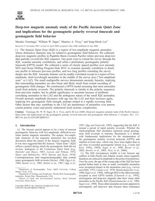
Figure 3<br />
5<strong>of</strong>20
B07110<br />
TOMINAGA ET AL.: JURASSIC QUIET ZONE MAGNETIC ANOMALIES<br />
B07110<br />
Figure 4. Correlation <strong>of</strong> deep-<strong>tow</strong> <strong>magnetic</strong> pr<strong>of</strong>iles in <strong>the</strong> NORTH survey area, upward continued to<br />
(a) sea surface and (b) midwater ( 3.0 km). Lines 92-1 and 92-2 are from Sager et al. [1998] (note that<br />
uppermost line is mostly line 92-2 with a small segment, line 3-6, added from recent survey). These older<br />
data are not shown deskewed as in some plots from Sager et al. [1998]. Plot shading and annotation<br />
conventions as in Figure 3. Locations shown in Figures 1 and 2.<br />
[Parker and Huestis, 1974] to make a preliminary interpretation<br />
<strong>of</strong> magnetization and to refine <strong>the</strong> fit <strong>of</strong> observed and<br />
modeled anomalies with forward modeling [Parker, 1972]<br />
(see description in Figure S2). Cande and Kent [1992a]<br />
used zero-crossings <strong>of</strong> deskewed anomalies (similar to our<br />
inverse magnetization model) to determine polarity boundaries;<br />
however, because <strong>the</strong> JQZ <strong>magnetic</strong> anomalies have<br />
low amplitude, it is difficult to determine polarity boundaries<br />
solely by zero-crossings. Long wavelength <strong>magnetic</strong><br />
variations and <strong>the</strong> adjustment <strong>of</strong> <strong>the</strong> local annihilator function<br />
(which we set to zero under <strong>the</strong> assumption <strong>of</strong> equal<br />
normal and reversed polarity crust) can both affect zero<br />
crossings for <strong>the</strong> small JQZ anomalies, so we used zerocrossings<br />
only for a first approximation <strong>of</strong> polarity boundary<br />
locations.<br />
[16] For both inverse and forward models, we filtered out<br />
long (>140 km) and short wavelengths (
B07110<br />
TOMINAGA ET AL.: JURASSIC QUIET ZONE MAGNETIC ANOMALIES<br />
B07110<br />
Figure 5. Plot <strong>of</strong> seismic pr<strong>of</strong>ile and deep-<strong>tow</strong> <strong>magnetic</strong> data. (a) Spatial relationship <strong>of</strong> seismic lines<br />
from MESOPAC II [Lancelot, 1989] and survey lines from this <strong>study</strong>. Solid lines show <strong>magnetic</strong> survey<br />
line in this <strong>study</strong> and dotted lines are lines 6-13 and 10 from MESOPAC II. (b) Line 10 seismic data from<br />
MESOPAC II. Vertical line indicates <strong>the</strong> location <strong>of</strong> Hole 801 C. (c) Line 6-13 seismic data from<br />
MESOPAC II. (d) Seafloor and oceanic basement interpreted from data shown in Figure 5c. (e) 5.5 km<br />
level Line 3-9 <strong>magnetic</strong> line from this <strong>study</strong> shows that <strong>magnetic</strong> anomalies are not correlated to<br />
basement topography.<br />
Hole 801C. We used a pale<strong>of</strong>ield inclination and declination<br />
<strong>of</strong> 10° and 20°, respectively (from Larson and Sager<br />
[1992]) and defined <strong>the</strong> strike <strong>of</strong> <strong>the</strong> <strong>magnetic</strong> anomalies as<br />
135° clockwise from north (from Sager et al. [1998]).<br />
Although Tivey et al. [2006] suggested that <strong>the</strong>re may be<br />
slight directional changes in <strong>anomaly</strong> strikes, we kept this<br />
constant strike because <strong>the</strong> strike changes are uncertain<br />
and this assumption is consistent with previous studies<br />
[Handschumacher et al., 1988; Sager et al., 1998] (also<br />
see sections 3.1, 4.1, and 4.4). Magnetic models require<br />
appropriate values for <strong>the</strong> seafloor depth, sediment thickness,<br />
and thickness <strong>of</strong> <strong>the</strong> <strong>magnetic</strong> source layer. While<br />
seafloor depth is available from <strong>the</strong> DSL-120 side-scan<br />
sonar data, <strong>the</strong> depth <strong>of</strong> igneous basement must be interpreted<br />
from sparse, pre-existing seismic pr<strong>of</strong>iles [Abrams et<br />
al., 1993] and <strong>the</strong> Hole 801C. We were unable to obtain<br />
seismic data along <strong>the</strong> deep-<strong>tow</strong> pr<strong>of</strong>iles during <strong>the</strong> TN152<br />
cruise because <strong>of</strong> time and logistical limitations. For simplicity<br />
in modeling, we used a constant depth for <strong>the</strong><br />
seafloor and sediment thickness within each survey subarea:<br />
5.6 and 6.1 km (seafloor and basement) for <strong>the</strong> M34<br />
survey, 5.6 and 6.2 km for <strong>the</strong> NORTH survey, 5.5<br />
and 5.9 km for <strong>the</strong> H801C survey, and 5.6 and 6.1 km<br />
for <strong>the</strong> SOUTH survey. As shown in Figure 5, changes in<br />
seafloor depth and sediment thickness are mostly gentle, so<br />
<strong>the</strong>se approximations should be reasonable. For reference,<br />
7<strong>of</strong>20
B07110<br />
TOMINAGA ET AL.: JURASSIC QUIET ZONE MAGNETIC ANOMALIES<br />
B07110<br />
Figure 6. Polarity block models. Square-wave pr<strong>of</strong>iles represent magnetization for polarity block<br />
models with positive magnetization (above zero lines) representing normal polarity and negative,<br />
reversed polarity. Dotted lines show correlations. Solid lines show deep-<strong>tow</strong> <strong>magnetic</strong> <strong>anomaly</strong> data.<br />
(a) Polarity block model for <strong>the</strong> NORTH survey area. Model ‘‘92 composite’’ at top is from Sager et al.<br />
[1998]. Line 3-6, 5, and 3-9, 4-1 models are from this <strong>study</strong>. ‘‘Composite model’’ at center is a<br />
combination <strong>of</strong> all polarity block models. (b) Polarity block model for <strong>the</strong> H801 survey area. The polarity<br />
model was derived from a stack <strong>of</strong> nine <strong>anomaly</strong> pr<strong>of</strong>iles; line 3-9 is shown here as an example compared<br />
with <strong>the</strong> predicted model field. (c) Polarity block model for <strong>the</strong> SOUTH survey area Top pr<strong>of</strong>iles show<br />
<strong>the</strong> observed (bold) and predicted anomalies for line-1. Bottom pr<strong>of</strong>iles show observed (bold) and<br />
modeled anomalies for line 3-9. Center square wave plots show polarity model correlations and final<br />
‘‘combined’’ model. Plot conventions as in previous figures.<br />
<strong>the</strong> sediment thickness drilled at Hole 801C was approximately<br />
463 m [Plank et al., 2000].<br />
[17] Although <strong>the</strong>re is no constraint for <strong>the</strong> thickness <strong>of</strong><br />
<strong>the</strong> <strong>magnetic</strong> source layer, most marine <strong>magnetic</strong> models<br />
assume that <strong>the</strong> crustal extrusive lavas are <strong>the</strong> primary<br />
source and have thicknesses <strong>of</strong> 500 to 1000 m. The<br />
extrusive layer in Hole 801C is at least 474 m thick [Plank<br />
et al., 2000], but since we do not know how much <strong>of</strong> that<br />
layer extends below <strong>the</strong> bottom <strong>of</strong> <strong>the</strong> hole, we chose 1000 m<br />
as <strong>the</strong> nominal source layer thickness for modeling. This<br />
choice for source layer thickness is not likely to have a<br />
significant effect on <strong>the</strong> interpretation <strong>of</strong> modeled polarity<br />
sequence.<br />
[18] After a preliminary polarity model was derived from<br />
<strong>the</strong> inverse calculations, this model was used as <strong>the</strong> input<br />
magnetization distribution for subsequent forward modeling.<br />
In <strong>the</strong> forward model, magnetization strength was<br />
estimated from <strong>the</strong> standard deviation <strong>of</strong> <strong>the</strong> absolute values<br />
8<strong>of</strong>20
B07110<br />
TOMINAGA ET AL.: JURASSIC QUIET ZONE MAGNETIC ANOMALIES<br />
B07110<br />
on ano<strong>the</strong>r line, <strong>the</strong> multiple blocks were merged and<br />
modeled as one polarity period in <strong>the</strong> composite model.<br />
This procedure minimizes <strong>the</strong> number <strong>of</strong> modeled polarity<br />
blocks.<br />
2.5. Age Calibration<br />
[20] Mesozoic <strong>magnetic</strong> anomalies have only a few good<br />
absolute age calibration points with which to interpolate or<br />
extrapolate <strong>the</strong> ages <strong>of</strong> chron boundaries. Sager et al. [1998]<br />
used <strong>the</strong> radiometric date <strong>of</strong> M26r (155.3 ± 3.4 Ma) from<br />
<strong>the</strong> Argo Abyssal plain [Ludden, 1992] to tie <strong>the</strong> 1992 deep<strong>tow</strong><br />
lines to that <strong>anomaly</strong> in Pigafetta Basin. They extrapolated<br />
<strong>the</strong> ages <strong>of</strong> blocks from M25 backward in time using<br />
<strong>the</strong> existing GPTS at <strong>the</strong> time [e.g., Gradstein et al., 1995;<br />
Handschumacher et al., 1988]. Our approach was to use <strong>the</strong><br />
absolute age for M26r and a new high-precision age<br />
determination for <strong>the</strong> tholeiitic basalt layer in Hole 801C<br />
(167.4 ± 1.7 Ma) [Koppers et al., 2003a] as tie points on<br />
both ends <strong>of</strong> <strong>the</strong> survey lines, with linear interpolation in<br />
between, assuming a constant spreading rate. The interpolation<br />
used <strong>the</strong> following age-distance relation:<br />
AgeðMaÞ ¼0:0146 distanceðkmÞþ155:3Ma;<br />
Figure 6.<br />
(continued)<br />
<strong>of</strong> magnetization values calculated by inverse modeling.<br />
Although Sager et al. [1998] applied an exponential reduction<br />
in <strong>the</strong> magnetization strength with an initial magnetization<br />
<strong>of</strong> 2.25 Am 1 , we did not find this model to be an<br />
especially good approximation for <strong>the</strong> new data. For our<br />
analysis, <strong>anomaly</strong> amplitudes were adequately approximated<br />
with a constant magnetization in each <strong>of</strong> <strong>the</strong> <strong>study</strong> areas.<br />
The magnetization values used in this <strong>study</strong> are as follows:<br />
3.9 Am 1 for M34, 1.7 Am 1 for H801C, 2.0 Am 1 for<br />
NORTH, and 2.3 Am 1 for SOUTH. These values provide<br />
<strong>the</strong> best match in terms <strong>of</strong> amplitude and shape between<br />
observed and calculated <strong>magnetic</strong> anomalies. The magnetizations<br />
for H801C, NORTH, and SOUTH are essentially<br />
<strong>the</strong> same. The M34 survey magnetization is nearly twice as<br />
high because <strong>the</strong> <strong>magnetic</strong> anomalies in that area have<br />
significantly larger amplitudes (Figures 2 and 3). A Gaussian<br />
filter (s = 7 km) was applied to <strong>the</strong> forward models to<br />
give finite-width reversal transitions, which give a better fit<br />
<strong>of</strong> observed and modeled <strong>anomaly</strong> slopes [Schouten and<br />
Denham, 1979].<br />
2.4. Composite Model<br />
[19] Once <strong>magnetic</strong> polarity block models were constructed<br />
for each survey line, a composite model was<br />
compiled from <strong>the</strong> overlapping lines (Figures 6 and 7.<br />
The purpose was to create a reversal sequence common to<br />
all lines within a given survey area. From <strong>the</strong> Sager et al.<br />
[1998] <strong>study</strong>, we adopted <strong>the</strong> composite model for <strong>the</strong> two<br />
previous deep-<strong>tow</strong> lines (92-1 and 92-2) as a starting point<br />
for <strong>the</strong> NORTH area where new and old data overlap. The<br />
boundary locations <strong>of</strong> each polarity block in <strong>the</strong> composite<br />
model were calculated by averaging values <strong>of</strong> corresponding<br />
block boundary distances. In <strong>the</strong> case <strong>of</strong> two or more<br />
polarity blocks on one line corresponding to only one block<br />
corresponding to a half spreading rate <strong>of</strong> 67 km/Ma<br />
(Figure S3). To make an age model for anomalies older and<br />
younger than <strong>the</strong> calibration points, we extrapolated this<br />
relation, using <strong>the</strong> polarity block model <strong>of</strong> Sager et al.<br />
[1998] for younger anomalies.<br />
[21] Error estimates for <strong>the</strong> two radiometric dates contribute<br />
an uncertainty in <strong>the</strong> modeled spreading rate. The<br />
minimum and maximum slopes that fit <strong>the</strong> 1-sigma uncertainty<br />
bounds on <strong>the</strong> radiometric ages are 51 km/Ma and<br />
98 km/Ma. Although such extreme slopes are possible given<br />
<strong>the</strong> calibration point uncertainties, <strong>the</strong> highest and lowest<br />
implied values are unlikely because <strong>the</strong>y quickly produce<br />
unreasonable ages when extrapolated outside <strong>the</strong> local survey<br />
region.<br />
3. Results<br />
3.1. Anomaly Correlation<br />
[22] What is ‘‘good’’ correlation? Naturally, this is subjective<br />
and what is considered good or acceptable correlation<br />
varies among analysts. To provide a quantitative<br />
foundation, we computed coherency (cross-correlation)<br />
among many <strong>of</strong> <strong>the</strong> deep-<strong>tow</strong> pr<strong>of</strong>iles and a comparison<br />
with established correlated sea surface anomalies (Figure 8).<br />
With ‘‘good’’ correlation, anomalies on adjacent pr<strong>of</strong>iles<br />
have similar shape and spacing. Such pr<strong>of</strong>iles have low-lag<br />
coherency values typically above 0.6 (e.g., GH824A<br />
versus GH7901 in Figure 8). Pr<strong>of</strong>iles with anomalies that<br />
show dissimilarities in <strong>anomaly</strong> size and shape (e.g.,<br />
GH824B versus GH7901 in Figure 8), typically have lowlag<br />
coherency values <strong>of</strong> less than 0.4. In our <strong>study</strong> area, <strong>the</strong><br />
between-line correlation <strong>of</strong> <strong>the</strong> deep-<strong>tow</strong> anomalies in our<br />
<strong>study</strong> is mostly excellent to good in all areas except for <strong>the</strong><br />
NORTH area. The best correlation was in <strong>the</strong> M34 survey<br />
where anomalies were closely matched on adjacent lines<br />
(Figure 3). In <strong>the</strong> M34 survey, <strong>anomaly</strong> amplitudes are<br />
relatively large (500 nT) and <strong>the</strong> anomalies show only<br />
small differences in <strong>anomaly</strong> shape and size between lines.<br />
9<strong>of</strong>20
B07110<br />
TOMINAGA ET AL.: JURASSIC QUIET ZONE MAGNETIC ANOMALIES<br />
B07110<br />
Figure 7. Polarity block model for entire survey, shown for midwater depth ( 3.0 km). Magnetic<br />
anomalies have not been deskewed. Top two solid curves show observed <strong>magnetic</strong> anomalies at sea<br />
surface (0 km) and 3 km depth. Dotted curve shows calculated <strong>magnetic</strong> anomalies. Bottom square wave<br />
plots show final combination model based on reconciling <strong>the</strong> 92 model and <strong>the</strong> new data.<br />
Correlation functions between lines are >0.5 at low <strong>of</strong>fset<br />
(Figure 8), indicating a high level <strong>of</strong> agreement. The worst<br />
correlation was in <strong>the</strong> NORTH survey area, which contains<br />
small, difficult-to-correlate anomalies as we had found<br />
previously in <strong>the</strong> 1992 survey (Figure 4).<br />
[23] Pr<strong>of</strong>iles in <strong>the</strong> H801 survey, where <strong>anomaly</strong> amplitudes<br />
are mostly 0.5 for lines 2-7 and 2-3, which<br />
are 10 km apart, but never >0.2 for lines 2-7 and 3-9,<br />
which are 30 km apart (Figures 3, 8). The reasons for <strong>the</strong><br />
poor correlation are apparent from an inspection <strong>of</strong> <strong>the</strong> two<br />
pr<strong>of</strong>iles (Figure 3); <strong>the</strong>se are probably <strong>the</strong> most dissimilar<br />
lines in terms <strong>of</strong> <strong>anomaly</strong> spacing and amplitude. Never<strong>the</strong>less,<br />
<strong>the</strong>se two pr<strong>of</strong>iles exhibit obvious similarities. For<br />
example, for line 3-9 <strong>the</strong> two main anomalies allowing<br />
correlation are <strong>the</strong> deep low on <strong>the</strong> north center end <strong>of</strong> <strong>the</strong><br />
line (13 km from north end) and <strong>the</strong> large, double-positive<br />
<strong>anomaly</strong> on <strong>the</strong> south end (10 km from south end)<br />
(Figure 3). In most studies <strong>of</strong> <strong>magnetic</strong> anomalies, this degree<br />
<strong>of</strong> correlation would be considered acceptable. Because <strong>of</strong><br />
<strong>the</strong> <strong>anomaly</strong> variations, correlation in <strong>the</strong> H801 area would<br />
be less convincing if only two or three widely spaced<br />
pr<strong>of</strong>iles were available, a factor to be considered when we<br />
interpret o<strong>the</strong>r areas <strong>of</strong> JQZ data.<br />
[24] Anomalies in <strong>the</strong> SOUTH survey have amplitudes <strong>of</strong><br />
200 nT (Figure 3). Although we have only two lines (lines<br />
1 and 3-9) located 30 km apart, <strong>the</strong>y display generally<br />
good agreement between <strong>the</strong> large <strong>anomaly</strong> shapes and<br />
locations, albeit with some variation in small features,<br />
spacing, and amplitude (Figure 3). The correlation coefficient<br />
for <strong>the</strong>se two lines peaks at just under 0.5, but can be<br />
increased to >0.6 with small (
B07110<br />
TOMINAGA ET AL.: JURASSIC QUIET ZONE MAGNETIC ANOMALIES<br />
B07110<br />
Figure 8. Cross-correlation functions <strong>of</strong> selected <strong>magnetic</strong> pr<strong>of</strong>iles. Cross-correlation between deep<strong>tow</strong><br />
pr<strong>of</strong>iles shown in upper row <strong>of</strong> boxes: (left) lines 5-11, 12, 13 in <strong>the</strong> M34 area; (middle) lines 2-3,<br />
7, and 3-9 in <strong>the</strong> H801 area; and (right) lines 1 and 3-9 in <strong>the</strong> SOUTH area. In <strong>the</strong> latter plot, <strong>the</strong> solid<br />
line shows <strong>the</strong> improved coherency attained with modified spacing <strong>of</strong> anomalies on line 1 (see text and<br />
Figure 3). Cross-correlation was not plotted for NORTH area lines because <strong>the</strong> correlation function is<br />
small (
B07110<br />
TOMINAGA ET AL.: JURASSIC QUIET ZONE MAGNETIC ANOMALIES<br />
B07110<br />
Figure 9. Power spectra for two segments <strong>of</strong> deep-<strong>tow</strong><br />
<strong>magnetic</strong> line 4-1. Vertical axis (logarithmic) plots power<br />
spectral density and horizontal axis is frequency. Locations<br />
<strong>of</strong> line segments are shown in <strong>the</strong> inset. Part A is from LAZ<br />
region whereas Part B is from H801 survey. Arrows show<br />
break-points on Part A and B spectra.<br />
(Figure 6), than <strong>the</strong> previous deep-<strong>tow</strong> model. Because <strong>of</strong><br />
<strong>the</strong> method we used to construct <strong>the</strong> composite polarity<br />
block model (i.e., using <strong>the</strong> minimum number <strong>of</strong> correlated<br />
blocks), this mismatch meant that many <strong>of</strong> <strong>the</strong> smaller<br />
blocks from <strong>the</strong> new pr<strong>of</strong>ile were omitted from <strong>the</strong> composite<br />
polarity model. To assist in correlating blocks in this<br />
difficult area, we also constructed and correlated polarity<br />
block models using upward continued pr<strong>of</strong>iles at 3.0 and<br />
0.0 km. The middle depth model ( 3.0 km) compared best<br />
with <strong>the</strong> model <strong>of</strong> Sager et al. [1998] (Figure 7) because its<br />
resolution was similar to <strong>the</strong> shallower deep-<strong>tow</strong> <strong>magnetic</strong><br />
pr<strong>of</strong>iles collected during <strong>the</strong> earlier cruise. Although <strong>the</strong><br />
TN152 deep-<strong>tow</strong> model implies as many as 40 reversals<br />
in 100 km, <strong>the</strong> final composite model retains only about one<br />
third as many. We think it likely that some <strong>of</strong> <strong>the</strong>se shortwavelength<br />
anomalies are a result <strong>of</strong> geologic ‘‘noise’’ (e.g.,<br />
crustal tectonic emplacement processes, short-period external<br />
field fluctuations, or data collection artifacts).<br />
[29] To consider <strong>the</strong> contribution <strong>of</strong> geologic noise, we<br />
calculated power spectra [Spector and Grant, 1970;<br />
Nwogbo, 1998] for two segments <strong>of</strong> TN152 lines 4-1 and<br />
3-9, one corresponding to <strong>the</strong> LAZ and <strong>the</strong> o<strong>the</strong>r from <strong>the</strong><br />
vicinity <strong>of</strong> H801 (Figure 9). We expected to see differences<br />
in <strong>the</strong> spectra because <strong>of</strong> <strong>the</strong> apparent difference in dominant<br />
<strong>anomaly</strong> wavelengths (Figure 10). A plot <strong>of</strong> power<br />
spectral density shows two approximately linear sections<br />
with a break in slope at 0.9 cycle/km for <strong>the</strong> H801 section<br />
and 0.7 cycle/km for <strong>the</strong> LAZ section. The almost-flat,<br />
high-wave number (short-wavelength) section in each spectra<br />
is usually interpreted as a noise component [e.g., Parker,<br />
1997]. This observation suggests that <strong>the</strong>re is no coherent<br />
geologic information at wave numbers >0.7–0.9 cycle/km.<br />
Consequently, polarity blocks smaller than 1.2 km<br />
(corresponding to wave number 0.8) were dropped from<br />
<strong>the</strong> polarity model.<br />
3.3. Polarity Reversal Models<br />
[30] We constructed two <strong>Jurassic</strong> GPTS models (Tables 1–<br />
2, Figure 11) following <strong>the</strong> rationale <strong>of</strong> Sager et al. [1998] by<br />
producing one at deep-<strong>tow</strong> depth ( 5.5 km) and one at<br />
midwater depth ( 3 km). In assigning chron numbers to<br />
our polarity block model, we numbered anomalies using <strong>the</strong><br />
upward-continued, sea level data to be compatible with<br />
previous GPTS studies that used sea level data (Figures 7<br />
and 11) [Handschumacher et al., 1988; Cande and Kent,<br />
1992a; Sager et al., 1998]. The model derived from <strong>the</strong><br />
5.5 km depth data assumes that most <strong>of</strong> <strong>the</strong> small anomalies<br />
(>1.2 km in width) in <strong>the</strong> deep-<strong>tow</strong> pr<strong>of</strong>iles result from<br />
polarity reversals. This gives a large number <strong>of</strong> polarity<br />
chrons and is likely an overestimate <strong>of</strong> <strong>the</strong> actual number<br />
<strong>of</strong> reversal periods. The GPTS model constructed from<br />
midwater depth pr<strong>of</strong>iles may underestimate <strong>the</strong> number <strong>of</strong><br />
polarity reversals, but because it is approximately 3 km<br />
above <strong>the</strong> source layer, it is comparable to o<strong>the</strong>r GPTS<br />
models constructed from <strong>magnetic</strong> pr<strong>of</strong>iles over younger<br />
oceanic lithosphere. We did not apply a 30 ka cut<strong>of</strong>f for<br />
cryptochrons, as did Cande and Kent [1992a], because this<br />
duration is somewhat arbitrary.<br />
[31] Although both deep-<strong>tow</strong> and midwater GPTS models<br />
(Tables 1 and 2) include polarity durations shorter than 30 ka,<br />
<strong>the</strong>se short duration chrons only represent 12.5% and 3% <strong>of</strong><br />
<strong>the</strong> total number <strong>of</strong> polarity blocks, respectively. The deep<strong>tow</strong><br />
model <strong>of</strong> <strong>the</strong> LAZ and H801 areas shows somewhat<br />
shorter polarity periods than <strong>the</strong> midwater model, with<br />
Figure 10. Composite <strong>anomaly</strong> pr<strong>of</strong>ile at 4.5 km depth anomalies over <strong>the</strong> Pigafetta JQZ showing<br />
change in <strong>anomaly</strong> amplitude with age. This composite was constructed from Line 1 <strong>of</strong> Sager et al.<br />
[1998] and Lines 4-1 and 3-9 from <strong>the</strong> subsequent survey. The abbreviation ‘‘smt’’ denotes an <strong>anomaly</strong><br />
caused by a small seamount. Hole 801C location is shown by star symbol.<br />
12 <strong>of</strong> 20
B07110<br />
TOMINAGA ET AL.: JURASSIC QUIET ZONE MAGNETIC ANOMALIES<br />
B07110<br />
Figure 11. Geo<strong>magnetic</strong> polarity timescales for <strong>the</strong> <strong>Pacific</strong> JQZ derived in this <strong>study</strong> (left) and prior<br />
studies. Left column shows polarity models constructed in this <strong>study</strong>. That on <strong>the</strong> left was modeled from<br />
deep-<strong>tow</strong> data, whereas that on <strong>the</strong> right was modeled from midwater depth pr<strong>of</strong>iles. Middle and right<br />
columns show polarity models from prior studies. In all columns, black denotes normal polarity and<br />
white is reversed polarity. Polarity chrons are listed in Tables 1 and 2.<br />
durations between 14 to 233 ka (average 99 ka). In <strong>the</strong>se<br />
areas, approximately 15% <strong>of</strong> <strong>the</strong> modeled polarity chrons<br />
have
B07110<br />
TOMINAGA ET AL.: JURASSIC QUIET ZONE MAGNETIC ANOMALIES<br />
B07110<br />
Table 1. <strong>Deep</strong>-Tow Geo<strong>magnetic</strong> Polarity Reversal Timescale<br />
Model<br />
Distance (km)<br />
Age (Ma)<br />
Chron Young Old Young Old<br />
M27r 14.0 25.8 155.5 155.7<br />
M28r 47.3 58.0 156.0 156.2<br />
M28Ar 65.1 81.9 156.3 156.5<br />
M28Br 85.5 91.8 156.6 156.7<br />
M28Cr 99.4 105.9 156.8 156.9<br />
M28Dr 111.6 119.5 157.0 157.1<br />
M29n.1r 130.6 132.8 157.2 157.3<br />
M29r 137.5 154.4 157.3 157.6<br />
M29Ar 157.9 162.6 157.7 157.7<br />
M30r 171.5 183.0 157.9 158.0<br />
M30Ar 190.1 192.4 158.1 158.2<br />
M31n1r 203.5 209.4 158.3 158.4<br />
M31n2r 211.4 214.4 158.4 158.5<br />
M31r 217.5 221.4 158.5 158.6<br />
M32n1r 223.0 225.1 158.6 158.7<br />
M32n2r 232.1 235.9 158.8 158.8<br />
M32r 238.0 244.0 158.8 158.9<br />
M33r 265.3 274.8 159.3 159.4<br />
M33Ar 280.4 285.4 159.5 159.6<br />
M33Br 290.3 298.4 159.6 159.7<br />
M33Cn1r 301.1 304.9 159.8 159.8<br />
M33Cr 313.6 328.3 159.9 160.2<br />
M34n1r 333.9 339.1 160.3 160.4<br />
M34n2r 342.3 344.4 160.4 160.4<br />
M34n3r 345.9 349.9 160.5 160.5<br />
M34Ar 352.3 361.6 160.5 160.7<br />
M34Bn1r 368.1 372.5 160.8 160.9<br />
M34Br 374.5 376.8 160.9 160.9<br />
M35r 381.5 391.9 160.9 161.1<br />
M36n1r 399.4 403.4 161.3 161.3<br />
M36Ar 406.5 407.9 161.4 161.4<br />
M36Br 410.1 420.2 161.4 161.6<br />
M36Cr 425.2 434.1 161.6 161.8<br />
M37n1r 451.5 459.7 162.0 162.2<br />
M37r 467.7 474.6 162.3 162.4<br />
M38n1r 484.0 487.5 162.5 162.6<br />
M38n2r 498.0 500.9 162.7 162.8<br />
M38n3r 506.5 514.5 162.8 162.9<br />
M38n4r 530.3 535.2 163.2 163.3<br />
M38r 546.3 551.0 163.4 163.5<br />
M39n1r 563.4 571.5 163.7 163.8<br />
M39n2r 581.6 586.3 163.9 164.0<br />
M39n3r 595.3 604.4 164.2 164.3<br />
M39n4r 614.8 626.9 164.5 164.6<br />
M39n5r 635.6 644.5 164.8 164.9<br />
M39n6r 651.3 658.5 165.0 165.1<br />
M39n7r 663.3 666.5 165.2 165.2<br />
M39r 673.4 678.7 165.3 165.4<br />
M40n1r 681.5 694.1 165.5 165.6<br />
M40n2r 698.8 705.1 165.7 165.8<br />
M40n3r 709.7 725.7 165.9 166.1<br />
M40r 727.9 732.8 166.1 166.2<br />
M41n1r 738.5 751.6 166.3 166.5<br />
M41n2r 756.2 763.5 166.6 166.7<br />
M41n3r 767.7 774.9 166.7 166.8<br />
M41r 776.8 784.5 166.9 166.9<br />
M42n1r 791.8 799.2 167.1 167.2<br />
M42n2r 800.7 803.7 167.2 167.3<br />
M42n3r 807.2 809.9 167.3 167.4<br />
M42n4r 811.6 812.8 167.4 167.4<br />
M42n5r 815.6 817.2 167.5 167.5<br />
M42n6r 818.9 819.9 167.5 167.5<br />
M42n7r 821.9 823.6 167.5 167.6<br />
M42n8r 825.2 828.1 167.6 167.6<br />
M42n9r 832.8 841.5 167.7 167.8<br />
M42n10r 843.1 855.9 167.9 168.1<br />
M42r 857.6 864.1 168.1 168.2<br />
M43n1r 865.2 874.4 168.2 168.3<br />
M43n2r 881.4 887.1 168.4 168.5<br />
M43n3r 890.8 894.0 168.6 168.6<br />
Table 1. (continued)<br />
Distance (km)<br />
Age (Ma)<br />
Chron Young Old Young Old<br />
M43n4r 896.3 901.1 168.7 168.7<br />
M43r 906.0 911.6 168.8 168.9<br />
M44n1r 915.0 918.0 168.9 168.9<br />
M44n2r 919.7 923.2 169.0 169.1<br />
M44n3r 925.7 935.3 169.1 169.2<br />
M44n4r 936.5 940.4 169.3 169.3<br />
M44n5r 941.6 946.8 169.3 169.4<br />
M44n6r 947.6 952.4 169.4 169.5<br />
M44n7r 953.1 956.0 169.5 169.5<br />
M44n8r 959.8 961.6 169.6 169.6<br />
M44r 964.4 967.0 169.7 169.7<br />
M45r 968.6 169.7<br />
result is a lesser number <strong>of</strong> blocks in <strong>the</strong> composite polarity<br />
model. In contrast, <strong>the</strong> numerous pr<strong>of</strong>iles in <strong>the</strong> H801<br />
survey allowed many short-wavelength anomalies to be<br />
correlated in that area.<br />
4. Discussion<br />
[34] In this <strong>study</strong>, we correlated and modeled deep-<strong>tow</strong><br />
<strong>magnetic</strong> <strong>anomaly</strong> pr<strong>of</strong>iles in <strong>the</strong> <strong>Pacific</strong> JQZ using new<br />
data to complement previous deep-<strong>tow</strong> pr<strong>of</strong>iles collected in<br />
this area [Sager et al., 1998]. These new data augment <strong>the</strong><br />
previous <strong>study</strong> in several ways. Closely spaced lines allow<br />
for a detailed correlation <strong>of</strong> short-wavelength anomalies in<br />
two areas: one around M34 and <strong>the</strong> o<strong>the</strong>r at ODP Hole<br />
801C. The new data also provide additional information in<br />
areas <strong>of</strong> uncertain <strong>anomaly</strong> correlations (NORTH) as well as<br />
extending <strong>the</strong> JQZ deep-<strong>tow</strong> survey across Hole 801C to <strong>the</strong><br />
RSB [Handschumacher et al., 1988] (SOUTH). Additional<br />
data allow us to address several questions about <strong>the</strong> JQZ:<br />
(1) Are <strong>the</strong> shortest-wavelength anomalies mapped in previous<br />
JQZ studies correlatable? (2) Are correlatable anomalies<br />
found fur<strong>the</strong>r back in time within <strong>the</strong> JQZ? (3) Are<br />
apparent reversals in <strong>the</strong> 474-m basalt section cored at Hole<br />
801C representative <strong>of</strong> surrounding <strong>magnetic</strong> lineations?<br />
(4) What are <strong>the</strong> implications for <strong>the</strong> cause <strong>of</strong> JQZ?<br />
4.1. Anomaly Correlation<br />
[35] Closely spaced deep-<strong>tow</strong> <strong>magnetic</strong> pr<strong>of</strong>iles in <strong>the</strong><br />
M34 and H801 surveys show good to excellent correlation<br />
(i.e., similarity in terms <strong>of</strong> shape, position, and size) <strong>of</strong> both<br />
short- and long-wavelength anomalies. Although not quite<br />
as robust, partly owing to having only two pr<strong>of</strong>iles, correlation<br />
<strong>of</strong> anomalies in <strong>the</strong> SOUTH survey is also good as is <strong>the</strong><br />
correlation <strong>of</strong> anomalies in <strong>the</strong> nor<strong>the</strong>rn part <strong>of</strong> <strong>the</strong> Pigafetta<br />
JQZ, from M36 northwestward to M27 [Handschumacher et<br />
al., 1988; Sager et al., 1998]. For <strong>the</strong>se age sequences, <strong>the</strong><br />
correlation <strong>of</strong> anomalies on adjacent lines strongly suggests<br />
that <strong>the</strong> anomalies are linear, especially given <strong>the</strong> linearity<br />
<strong>of</strong> <strong>the</strong> anomalies in <strong>the</strong> two small surveys with closely<br />
spaced lines (M34 and H801). Thus, on <strong>the</strong> whole, <strong>the</strong> JQZ<br />
anomalies appear similar to o<strong>the</strong>r linear <strong>magnetic</strong> anomalies<br />
around <strong>the</strong> world that are attributed to <strong>magnetic</strong> reversals<br />
recorded by <strong>the</strong> process <strong>of</strong> seafloor spreading and crustal<br />
construction at midocean ridges.<br />
[36] In contrast, <strong>anomaly</strong> correlations are poor in <strong>the</strong><br />
300-km long LAZ. This section has <strong>the</strong> smallest amplitude<br />
anomalies measured and as previously noted is a zone<br />
14 <strong>of</strong> 20
B07110<br />
TOMINAGA ET AL.: JURASSIC QUIET ZONE MAGNETIC ANOMALIES<br />
B07110<br />
Table 2. Midwater Geo<strong>magnetic</strong> Polarity Reversal Timescale<br />
Model<br />
Distance (km)<br />
Age (Ma)<br />
Chron Young Old Young Old<br />
M37r 451.5 472.8 162.0 162.3<br />
M38n1r 480.4 485.2 162.5 162.6<br />
M38n2r 492.3 498.3 162.6 162.7<br />
M38n3r 504.1 512.1 162.8 162.9<br />
M38n4r 528.3 537.3 163.2 163.3<br />
M38r 543.5 555.9 163.4 163.6<br />
M39n1r 562.5 583.5 163.7 164.0<br />
M39n2r 614.9 625.7 164.5 164.6<br />
M39n3r 630.6 641.9 164.7 164.9<br />
M39n4r 647.6 655.0 164.9 165.1<br />
M39n5r 659.4 665.7 165.1 165.2<br />
M39r 671.6 677.5 165.3 165.4<br />
M40n1r 680.9 689.6 165.4 165.6<br />
M40n2r 697.6 703.8 165.7 165.8<br />
M40r 706.9 732.2 165.8 166.2<br />
M41n1r 736.3 739.6 166.3 166.3<br />
M41n2r 742.1 744.7 166.4 166.4<br />
M41r 755.3 781.3 166.6 166.9<br />
M42n1r 790.6 811.3 167.1 167.4<br />
M42n2r 817.7 823.1 167.5 167.6<br />
M42n3r 831.9 833.9 167.7 167.7<br />
M42r 850.7 860.6 167.9 168.1<br />
M43n1r 864.5 880.7 168.2 168.4<br />
M43n2r 888.8 897.5 168.5 168.7<br />
M43r 905.3 914.9 168.8 168.9<br />
M44n1r 931.7 961.2 169.2 169.6<br />
M44n2r 971.3 169.8<br />
<strong>of</strong> difficult correlation [Handschumacher et al., 1988; Sager<br />
et al., 1998]. Although <strong>the</strong> closely spaced tracks around<br />
Hole 801C illustrate that small anomalies can be successfully<br />
correlated, similar anomalies in <strong>the</strong> LAZ are difficult<br />
to match with <strong>the</strong> same certainty. One characteristic that<br />
makes anomalies in this zone difficult to correlate is <strong>the</strong><br />
mismatch <strong>of</strong> large, long wavelength anomalies. Although<br />
<strong>the</strong> two older deep-<strong>tow</strong> pr<strong>of</strong>iles have similar long-wavelength<br />
anomalies (indeed, Sager et al. [1998] used <strong>the</strong>se<br />
anomalies as a guide for correlating <strong>the</strong> smaller anomalies)<br />
<strong>the</strong> new deep-<strong>tow</strong> pr<strong>of</strong>ile in between has a different long<br />
wavelength appearance. The source <strong>of</strong> <strong>the</strong> long-wavelength<br />
anomalies is uncertain. Given <strong>the</strong> observed mismatch, <strong>the</strong>y<br />
do not appear linear in <strong>the</strong> LAZ. A possible cause is <strong>magnetic</strong><br />
overprinting by <strong>the</strong> Mid-Cretaceous volcanism that usually<br />
appears as sills intruded into <strong>the</strong> sediments. In this area, this<br />
volcanism appears patchy [Abrams et al., 1993] as do <strong>the</strong><br />
larger <strong>magnetic</strong> anomalies. Fur<strong>the</strong>rmore, <strong>the</strong> smallamplitude,<br />
short-wavelength character <strong>of</strong> <strong>the</strong> LAZ anomalies<br />
implies that <strong>the</strong>y may have o<strong>the</strong>r causes. For example,<br />
<strong>the</strong> <strong>magnetic</strong> field may have had rapid reversals or fluctuations<br />
that were too frequent to make strongly linear anomalies<br />
or <strong>the</strong> <strong>magnetic</strong> recording was degraded because <strong>of</strong> ridge<br />
jumps, propagating rifts or later volcanic activity. Currently,<br />
we do not have sufficient data to determine whe<strong>the</strong>r <strong>the</strong>se<br />
<strong>anomaly</strong> characteristics in <strong>the</strong> LAZ result from geo<strong>magnetic</strong><br />
field or volcanic artifacts.<br />
4.2. Polarity Reversal Models<br />
[37] We constructed a magnetization model <strong>of</strong> <strong>the</strong> deep<strong>tow</strong><br />
<strong>anomaly</strong> pr<strong>of</strong>iles to help understand <strong>the</strong> nature <strong>of</strong> <strong>the</strong><br />
anomalies. The assumption <strong>of</strong> alternating blocks <strong>of</strong> opposite<br />
polarity is convenient for modeling, although we do not<br />
know which <strong>of</strong> <strong>the</strong>se small anomalies results from a<br />
<strong>magnetic</strong> field reversal and which is simply a field intensity<br />
or directional fluctuation. Thus, taking <strong>the</strong> next step <strong>of</strong><br />
assigning ages and representing <strong>the</strong> sequence as a GPTS,<br />
has inherent risks. Correlations <strong>of</strong> some anomalies is poor<br />
and even those with apparently good correlations in our<br />
geographically restricted data set do not demonstrate that<br />
<strong>the</strong> observed pattern has global repeatability and significance.<br />
Never<strong>the</strong>less, we present a GPTS model here for two<br />
reasons. It is a natural extension <strong>of</strong> previous work that<br />
allows <strong>the</strong> reader to better understand <strong>the</strong> implications <strong>of</strong><br />
this <strong>study</strong> relative to those preceding it. More importantly,<br />
progress in developing a <strong>Jurassic</strong> GPTS requires it. The<br />
current mid-<strong>Jurassic</strong> to Early Cretaceous GPTS is based on<br />
Handshumacher et al. [1988] and Sager et al. [1998].<br />
Although <strong>the</strong> GPTS from this <strong>study</strong> contains uncertainties<br />
because <strong>of</strong> <strong>the</strong> small number <strong>of</strong> pr<strong>of</strong>iles, <strong>the</strong> limited extent,<br />
and <strong>the</strong> LAZ correlation difficulties, it is a template for<br />
magnetostratigraphic work and studies <strong>of</strong> JQZ anomalies<br />
elsewhere. Thus, in this <strong>study</strong>, we are obliged to consider<br />
<strong>the</strong> implications <strong>of</strong> <strong>the</strong> GPTS.<br />
[38] In building reversal models <strong>of</strong> <strong>the</strong> deep <strong>tow</strong> <strong>magnetic</strong><br />
lines, we made <strong>the</strong> traditional assumption that all significant<br />
anomalies result from <strong>magnetic</strong> reversals recorded by <strong>the</strong><br />
seafloor spreading process [Vine and Mat<strong>the</strong>ws, 1963].<br />
Although this assumption has been highly successful in<br />
creating GPTS models, several studies suggest that small<br />
anomalies may not always represent polarity reversals [e.g.,<br />
Cande and Kent, 1992b; Bowles et al., 2003]. An alternative<br />
to interpreting all anomalies as reversals is to consider<br />
that some <strong>of</strong> <strong>the</strong>m could be due to fluctuations <strong>of</strong> pale<strong>of</strong>ield<br />
intensity and <strong>magnetic</strong> field excursions (i.e., incomplete<br />
reversals). Statistically, reversals, excursions, and paleointensity<br />
fluctuations probably result from <strong>the</strong> same set <strong>of</strong><br />
geo<strong>magnetic</strong> instabilities, implying that <strong>the</strong>y would appear<br />
similar in <strong>magnetic</strong> pr<strong>of</strong>ile data [Marzocchi, 1997]. The<br />
nonuniqueness <strong>of</strong> potential field modeling does not allow us<br />
to determine which small anomalies represent true polarity<br />
reversals and which are simply <strong>magnetic</strong> field fluctuations.<br />
For <strong>the</strong>ir widely accepted GPTS model, Cande and Kent<br />
[1992a, 1992b] rejected polarity chrons with durations<br />
shorter than 30 ka as likely to result from paleointensity<br />
fluctuations. Similarly, Sager et al. [1998] constructed a<br />
<strong>Jurassic</strong> GPTS with a reversal for every <strong>magnetic</strong> <strong>anomaly</strong><br />
but preferred a model filtered by upward continuation to<br />
midwater depth because it retained reversals only for <strong>the</strong><br />
longer-wavelength anomalies.<br />
[39] To distinguish between reversals and field fluctuations,<br />
several investigator groups have compared sedimentary<br />
magnetostratigraphy with ‘‘cryptochrons’’ (i.e., small<br />
anomalies <strong>of</strong> uncertain cause in <strong>magnetic</strong> pr<strong>of</strong>iles). Lanci<br />
and Lowrie [1997] suggested that cryptochrons within C12<br />
and C13 in <strong>the</strong> timescale <strong>of</strong> Cande and Kent [1995] are<br />
paleointensity fluctuations ra<strong>the</strong>r than <strong>magnetic</strong> reversals<br />
because <strong>of</strong> a lack <strong>of</strong> corresponding polarity reversals in<br />
contemporaneous sediment cores. Similar conclusions were<br />
reached for small anomalies within chron C5 on <strong>the</strong> basis <strong>of</strong><br />
a strong correlation between deep-<strong>tow</strong> <strong>magnetic</strong> pr<strong>of</strong>iles and<br />
sedimentary relative paleointensity records [Bowers et al.,<br />
2001; Bowles et al., 2003]. In contrast, Roberts and Lewin-<br />
Harris [2000] concluded that small anomalies in chron C5<br />
result from polarity reversals, suggesting that even when<br />
15 <strong>of</strong> 20
B07110<br />
TOMINAGA ET AL.: JURASSIC QUIET ZONE MAGNETIC ANOMALIES<br />
B07110<br />
high-resolution sedimentary data are available, <strong>the</strong> interpretation<br />
<strong>of</strong> such data may not be straightforward. Fur<strong>the</strong>rmore,<br />
some investigators have concluded that <strong>the</strong> resolution <strong>of</strong><br />
sedimentary paleo<strong>magnetic</strong> records depends significantly on<br />
sedimentation rate and small anomalies can be averaged out<br />
if <strong>the</strong> sedimentation rate is not high enough [Roberts and<br />
Winklh<strong>of</strong>er, 2004]. Thus, <strong>the</strong> fidelity <strong>of</strong> sedimentary records<br />
may be verified only when <strong>the</strong> records show consistency at<br />
several sites around <strong>the</strong> world.<br />
[40] With our data set, consisting <strong>of</strong> <strong>magnetic</strong> pr<strong>of</strong>iles<br />
only, it is not possible to make a definitive interpretation <strong>of</strong><br />
<strong>the</strong> source <strong>of</strong> small <strong>magnetic</strong> anomalies observed in <strong>the</strong><br />
<strong>Pacific</strong> JQZ. Consequently, we simply constructed a <strong>Jurassic</strong><br />
GPTS assuming that those anomalies larger than 1.2 km<br />
wavelength (<strong>the</strong> smaller being noise) observed with <strong>the</strong> deep<strong>tow</strong><br />
magnetometer are caused by blocks <strong>of</strong> contrasting<br />
polarity.<br />
[41] As did Sager et al. [1998] for <strong>the</strong>ir model <strong>of</strong> <strong>the</strong> JQZ<br />
polarity reversal sequence, we prefer <strong>the</strong> model made from<br />
<strong>magnetic</strong> anomalies upward continued to midwater level<br />
because <strong>the</strong> upward continuation filters out many <strong>of</strong> <strong>the</strong><br />
shortest-wavelength features and gives results comparable<br />
to sea surface <strong>magnetic</strong> data near <strong>the</strong> present-day mid-ocean<br />
ridges. The deep-<strong>tow</strong> <strong>magnetic</strong> pr<strong>of</strong>iles show many shortwavelength<br />
features, some <strong>of</strong> which may result from phenomena<br />
o<strong>the</strong>r than <strong>magnetic</strong> reversals.<br />
[42] Several factors indicate that <strong>the</strong> GPTS must be<br />
treated with caution. Correlations are uncertain in some<br />
portions, especially <strong>the</strong> LAZ. It is impossible to determine,<br />
from <strong>magnetic</strong> pr<strong>of</strong>iles alone, whe<strong>the</strong>r small anomalies are<br />
caused by reversals. Fur<strong>the</strong>rmore, models made at different<br />
levels show differences related to <strong>the</strong> changing appearance<br />
<strong>of</strong> <strong>the</strong> anomalies when upward continued.<br />
4.3. Correlation <strong>of</strong> Models and Hole 801C Log Data<br />
[43] Despite ambiguities about <strong>the</strong> interpretations <strong>of</strong><br />
reversals in our GPTS models, two independent types <strong>of</strong><br />
data, <strong>magnetic</strong> data from Hole 801C and <strong>Jurassic</strong> <strong>magnetic</strong><br />
stratigraphy studies from continental sedimentary sections,<br />
support <strong>the</strong> existence <strong>of</strong> many short polarity periods, implying<br />
a rapid reversal frequency. Paleo<strong>magnetic</strong> and downhole<br />
logging data are available from <strong>the</strong> 474-m basalt<br />
section cored at Hole 801C. Both data sets imply six<br />
reversals in <strong>the</strong> section [Wallick and Steiner, 1982; Steiner,<br />
2001; Tivey et al., 2005]. Four polarity changes are found<br />
within <strong>the</strong> upper, 150-m, <strong>of</strong>f axis lava sequence while two<br />
polarity changes are found within <strong>the</strong> lower lava sequence,<br />
which was presumably accreted at or near <strong>the</strong> spreading<br />
axis. Formation microscanner (FMS) log data show significant<br />
dips in <strong>the</strong> lava sequences within <strong>the</strong> hole [Pockalny<br />
and Larson, 2003]. If <strong>the</strong> tilted lava sequence boundaries<br />
indicate that magnetization boundaries are similarly tilted,<br />
<strong>the</strong>n changes in <strong>magnetic</strong> polarity can occur within a<br />
vertical hole [Tivey et al., 2005]. The multiple polarities<br />
<strong>of</strong> <strong>the</strong> upper <strong>of</strong>f-axis lava sequence also implies rapid<br />
polarity reversal rate 7 Ma after <strong>the</strong> main crustal accretion<br />
occurred (167.4 Ma), which is consistent with <strong>the</strong> rapidly<br />
reversing field at M34 age (160 Ma). These observations<br />
along with <strong>the</strong> lineated character <strong>of</strong> <strong>magnetic</strong> anomalies<br />
around Hole 801C suggest that seafloor spreading has<br />
recorded rapid polarity reversals during this time period<br />
and <strong>the</strong> small anomalies are not just <strong>the</strong> signal <strong>of</strong> geo<strong>magnetic</strong><br />
field intensity fluctuations.<br />
[44] The finding <strong>of</strong> multiple polarity sections within <strong>the</strong><br />
Hole 801C section is suggestive <strong>of</strong> a high reversal rate;<br />
however, <strong>the</strong> actual rate is difficult to estimate because <strong>of</strong><br />
uncertainties about crustal architecture and accretion rates.<br />
Within M42 on our GPTS model (Figure 11), corresponding<br />
to <strong>the</strong> H801 survey area, <strong>the</strong> 5.5 km model implies a<br />
reversal rate <strong>of</strong> 26 rev/Ma (1 rev/38 ka). Alternatively, <strong>the</strong><br />
3.0 km model (Figure 11), which leaves out <strong>the</strong> smallest<br />
anomalies, gives only 8 rev/Ma (1 rev/125 ka).<br />
[45] The highest reversal rates for <strong>the</strong> accepted GPTS<br />
occurred during <strong>the</strong> Miocene, 10 Ma, with a rate <strong>of</strong><br />
5 rev/Ma. This is not greatly different from <strong>the</strong> lowest rates<br />
implied by <strong>the</strong> deep-<strong>tow</strong> <strong>magnetic</strong> pr<strong>of</strong>ile models and<br />
implies that <strong>the</strong> lower <strong>of</strong> inferred JQZ rates are not extreme.<br />
Fur<strong>the</strong>rmore, similar rates (6–8 rev/Ma) have been also<br />
interpreted from <strong>Jurassic</strong> continental magnetostratigraphic<br />
studies [Steiner et al., 1987; Steiner, 2001; J. Ogg, personal<br />
communication, 2004]. Our deep-<strong>tow</strong> GPTS model is <strong>the</strong>refore<br />
consistent with largely independent observations that<br />
imply many short polarity reversals during <strong>the</strong> <strong>Jurassic</strong>.<br />
4.4. Cause <strong>of</strong> <strong>the</strong> JQZ<br />
[46] <strong>Pacific</strong> JQZ deep-<strong>tow</strong> <strong>magnetic</strong> data provide a highresolution<br />
recording <strong>of</strong> apparently unusual geo<strong>magnetic</strong><br />
field behavior during <strong>the</strong> <strong>Jurassic</strong>. Although <strong>magnetic</strong><br />
anomalies are nonunique and by <strong>the</strong>mselves do not provide<br />
an unequivocal explanation for <strong>the</strong> JQZ, <strong>the</strong> data from this<br />
<strong>study</strong> give important clues about <strong>the</strong> factors involved.<br />
Generally, our inferences follow from systematic variations<br />
in <strong>the</strong> JQZ <strong>anomaly</strong> sequence and comparisons with independent<br />
data.<br />
[47] Systematic changes in <strong>anomaly</strong> amplitudes are observed<br />
along <strong>the</strong> deep-<strong>tow</strong> lines. Anomaly amplitude<br />
decreases with increasing age (i.e., <strong>tow</strong>ard <strong>the</strong> sou<strong>the</strong>ast)<br />
continuing <strong>the</strong> trend that has been noted by o<strong>the</strong>r authors<br />
[e.g., Cande et al., 1978; Sager et al., 1998; McElhinny and<br />
Larson, 2003; Tivey et al., 2006], reaching a minimum<br />
amplitude and shortest wavelength in <strong>the</strong> LAZ (Figure 10),<br />
tentatively identified as being between M38 and M41. At<br />
older ages (i.e., far<strong>the</strong>r sou<strong>the</strong>ast), <strong>anomaly</strong> amplitudes<br />
increase slightly south <strong>of</strong> Hole 801C. This trend is also<br />
seen in <strong>the</strong> modeled magnetization values (section 2.3),<br />
which decrease from M34 (3.9 Am 1 ) to NORTH<br />
(2.0 Am 1 ) and increase from H801C (1.7 Am 1 ) to<br />
SOUTH (2.3 Am 1 ). Although we used a constant thickness<br />
for <strong>the</strong> <strong>magnetic</strong> source layer for modeling, an alternative<br />
is to consider <strong>the</strong>se systematic changes as a result <strong>of</strong><br />
changes in source layer thickness, ra<strong>the</strong>r than variations in<br />
<strong>the</strong> geo<strong>magnetic</strong> field. We think this explanation is unlikely<br />
because <strong>of</strong> <strong>the</strong> large implied changes in source layer<br />
thickness. For example, to reproduce <strong>the</strong> <strong>anomaly</strong> amplitudes<br />
observed in <strong>the</strong> M34 and H801C areas with same<br />
magnetization value (e.g., 2.0 Am 1 ), <strong>the</strong> source layer<br />
thickness <strong>of</strong> M34 and H801C must be different by a factor<br />
>3 (0.7 and 3.0 km, for M34 and H801C, respectively). This<br />
much variation within fast spreading mid-ocean ridge crust<br />
with a flat seafloor topography is unlikely. Instead, following<br />
similar interpretations <strong>of</strong> <strong>the</strong> global <strong>magnetic</strong> <strong>anomaly</strong><br />
sequence [e.g., McElhinny and Larson, 2003], changes in<br />
JQZ <strong>anomaly</strong> amplitude imply changes in paleo<strong>magnetic</strong><br />
16 <strong>of</strong> 20
B07110<br />
TOMINAGA ET AL.: JURASSIC QUIET ZONE MAGNETIC ANOMALIES<br />
B07110<br />
Figure 12. Curves showing decline in model <strong>anomaly</strong><br />
amplitudes for small-width polarity blocks owing to lateral<br />
interference. Vertical axis is normalized model <strong>magnetic</strong><br />
<strong>anomaly</strong> amplitude. Horizontal axis is width <strong>of</strong> polarity<br />
block. Dotted line is model with vertical polarity block<br />
boundaries; solid line is model with dipping (53°) lateral<br />
boundaries.<br />
field strength, perhaps related to reversal rate. The field<br />
intensity seems to have decreased until reaching a minimum<br />
during <strong>the</strong> LAZ, where <strong>the</strong> fluctuation rate appears highest,<br />
and <strong>the</strong>n increased through <strong>the</strong> late <strong>Jurassic</strong> as reversal rate<br />
declined [Tivey et al., 2006].<br />
[48] Changes in <strong>anomaly</strong> amplitude on <strong>the</strong> deep-<strong>tow</strong><br />
pr<strong>of</strong>iles, particularly around <strong>the</strong> LAZ, may give clues about<br />
<strong>the</strong> origin <strong>of</strong> <strong>the</strong> JQZ. We consider several hypo<strong>the</strong>ses that<br />
may partly or completely explain <strong>the</strong> observed changes:<br />
(1) long-term decrease in crustal magnetization as a result <strong>of</strong><br />
ei<strong>the</strong>r alteration or decreased dipole field intensity, (2) low<br />
transitional field intensities combined with rapid reversals,<br />
(3) interference <strong>of</strong> <strong>the</strong> <strong>magnetic</strong> anomalies caused by closely<br />
spaced polarity blocks in <strong>the</strong> oceanic crust, and (4) a<br />
tectonic disruption in <strong>the</strong> LAZ perhaps caused by spreading<br />
ridge reorientation and/or propagation.<br />
[49] A decrease <strong>of</strong> crustal magnetizationgoing backward<br />
in time has been documented for <strong>the</strong> past 30 Ma and<br />
attributed to progressive alteration [Johnson and Pariso,<br />
1993]. This explanation does not seem likely for <strong>the</strong> JQZ<br />
because existing evidence implies that changes in magnetization<br />
beyond 30 Ma due to alteration are small [Johnson<br />
and Pariso, 1993]. More likely is that <strong>the</strong> overall decrease<br />
in <strong>anomaly</strong> amplitude [e.g., McElhinny and Larson, 2003]<br />
is a global phenomenon related to a decrease <strong>of</strong> geo<strong>magnetic</strong><br />
field strength. Independent, paleo<strong>magnetic</strong> data imply<br />
that <strong>the</strong> <strong>Jurassic</strong> was a time <strong>of</strong> low dipole field strength<br />
(so-called ‘‘Mesozoic dipole low’’) [e.g., Prévot et al., 1990;<br />
McElhinny and McFadden, 2000; Thomas and Biggin,<br />
2003; Biggin and Thomas, 2003].<br />
[50] One possible explanation for <strong>the</strong> LAZ is that <strong>the</strong><br />
geo<strong>magnetic</strong> field was weaker than normal during <strong>the</strong> LAZ<br />
because <strong>of</strong> rapid reversals and overlapping transitional field<br />
minima. It is well-known that <strong>the</strong> dipole field is reduced<br />
during geo<strong>magnetic</strong> field reversals, perhaps only to 25%<br />
<strong>of</strong> <strong>the</strong> nonreversing dipole field strength [Merrill and<br />
McFadden, 1999]. Fur<strong>the</strong>rmore, it is thought that periods<br />
<strong>of</strong> weaker field intensity are characterized by greater numbers<br />
<strong>of</strong> reversals and excursions [Valét et al., 2005]. Thus, we<br />
might expect that a period containing many, closely spaced<br />
reversals may also be a time <strong>of</strong> reduced field strength,<br />
perhaps because periods <strong>of</strong> transition field minima overlap<br />
(i.e., <strong>the</strong> field does not regain full strength before starting<br />
ano<strong>the</strong>r reversal). At face value, our deep-<strong>tow</strong> GPTS for <strong>the</strong><br />
LAZ implies only a reversal rate <strong>of</strong> 10 rev/Ma. This is not<br />
much higher than inferred Miocene reversal rates and<br />
implies an average time between reversals <strong>of</strong> 100 ka. If<br />
transitional field minima have durations <strong>of</strong> less than 10 ka<br />
[Merrill and McFadden, 1999], <strong>the</strong> overlap from polarity<br />
periods <strong>of</strong> <strong>the</strong> implied duration would be minimal. However,<br />
if field minima are broader (e.g., 60–80 ka) [Valét et<br />
al., 2005] or <strong>the</strong> reversal rate is substantially higher,<br />
overlapping field minima may be part <strong>of</strong> <strong>the</strong> reason for<br />
<strong>the</strong> apparent low LAZ <strong>anomaly</strong> amplitudes. Reversal rates<br />
in <strong>the</strong> LAZ may be significantly higher than implied by our<br />
GPTS because this model contains only <strong>the</strong> better-correlated<br />
ano-malies in a zone <strong>of</strong> poor correlation. If all anomalies are<br />
interpreted as a result <strong>of</strong> polarity reversals, <strong>the</strong> model for<br />
deep-<strong>tow</strong> lines 3-9, 4-1 implies a reversal rate <strong>of</strong> 12 rev/Ma<br />
(Figure 10), with an average period <strong>of</strong> 82 ka between<br />
transitions.<br />
[51] Ano<strong>the</strong>r potential factor causing <strong>the</strong> LAZ is overlapping<br />
and partially canceling <strong>magnetic</strong> anomalies caused<br />
by closely spaced blocks <strong>of</strong> opposing polarity. To judge <strong>the</strong><br />
plausibility <strong>of</strong> this hypo<strong>the</strong>sis, we calculated simple 2-D<br />
forward models [Talwani and Heirtzler, 1964] <strong>of</strong> crustal<br />
anomalies and tested <strong>the</strong> reduction <strong>of</strong> <strong>anomaly</strong> amplitude<br />
with different spacing <strong>of</strong> opposing polarity blocks. For<br />
simplicity, we assumed a 1 km thickness for <strong>the</strong> source<br />
layer, a distance <strong>of</strong> 500 m between <strong>the</strong> top <strong>of</strong> <strong>the</strong> source and<br />
<strong>the</strong> observation plane (similar to <strong>the</strong> TN152 deep-<strong>tow</strong><br />
magnetometer geometry), and sharp boundaries between<br />
polarity blocks (i.e., transition width <strong>of</strong> zero). Models were<br />
made at different reversal rates, which varied <strong>the</strong> width <strong>of</strong><br />
<strong>the</strong> polarity blocks. We also made two different models <strong>of</strong><br />
<strong>the</strong> polarity boundaries, one with vertical boundaries and<br />
ano<strong>the</strong>r with boundaries tilting 53° from vertical (<strong>the</strong> tilt<br />
angle inferred for Hole 801C layers by Pockalny and<br />
Larson [2003]). Overall, <strong>the</strong> intensity <strong>of</strong> anomalies from<br />
<strong>the</strong> tilted-boundary model is less than those <strong>of</strong> <strong>the</strong> nontilted<br />
model (Figure 12), presumably because <strong>the</strong> tilted blocks<br />
produce greater overlap <strong>of</strong> opposing polarity material. A<br />
similar result would be given with finite-width polarity<br />
transitions. Most importantly, <strong>the</strong> models show a precipitous<br />
drop in <strong>anomaly</strong> amplitudes when <strong>the</strong> polarity boundaries<br />
are less than 4 km apart and this result is approximately<br />
<strong>the</strong> same for both tilted and non-tilted polarity block<br />
boundaries. This finding implies that even at deep-<strong>tow</strong><br />
depths, <strong>the</strong>re can be a significant reduction in <strong>anomaly</strong><br />
amplitude caused by small-width polarity blocks. In some<br />
portions <strong>of</strong> <strong>the</strong> LAZ, small anomalies imply polarity blocks<br />
4 km or less in width. Thus, <strong>the</strong> partial cancellation <strong>of</strong><br />
overlapping anomalies may be a factor reducing LAZ<br />
<strong>anomaly</strong> amplitudes.<br />
[52] The poor correlation <strong>of</strong> LAZ anomalies may also<br />
result wholly or in part from tectonic and/or crustal accre-<br />
17 <strong>of</strong> 20
B07110<br />
TOMINAGA ET AL.: JURASSIC QUIET ZONE MAGNETIC ANOMALIES<br />
B07110<br />
tion complications. If <strong>the</strong>re were tectonic complexities, such<br />
as ridge jumps, propagating ridges, or microplate rotations,<br />
we could expect disturbed, difficult-to-correlate anomalies<br />
to be <strong>the</strong> result. One complication could be <strong>the</strong> superposition<br />
<strong>of</strong> lavas <strong>of</strong> differing ages owing to <strong>of</strong>f-axis eruptions.<br />
Cores from Hole 801C show both an <strong>of</strong>f-axis lava eruption<br />
and a late-stage akalic eruptions [Koppers et al., 2003a,<br />
2003b; Tivey et al., 2005]. Nei<strong>the</strong>r <strong>of</strong> <strong>the</strong>se later eruptions<br />
appears to have significantly degraded <strong>the</strong> correlation <strong>of</strong><br />
<strong>magnetic</strong> anomalies around Hole 801, even though <strong>the</strong>y<br />
represent a hiatus in crustal accretion that is much longer<br />
than <strong>the</strong> apparent reversal period. This suggests that <strong>the</strong><br />
Hole 801C primary <strong>magnetic</strong> layer is not significantly<br />
affected by <strong>the</strong> later eruptions. However, at ano<strong>the</strong>r site,<br />
such as <strong>the</strong> LAZ, later igneous activity may have confounded<br />
<strong>the</strong> crustal <strong>anomaly</strong> signal. Ano<strong>the</strong>r possible complication<br />
is tectonic reorganization, such as ridge realignment,<br />
ridge jumps, propagating rifts, or microplate formation.<br />
Owing to <strong>the</strong> paucity <strong>of</strong> well-defined <strong>magnetic</strong> lineations<br />
regionally, <strong>the</strong> history <strong>of</strong> <strong>Jurassic</strong> seafloor spreading in <strong>the</strong><br />
<strong>Pacific</strong> is poorly known. Because <strong>the</strong> JQZ <strong>magnetic</strong> anomalies<br />
are only well-defined in <strong>the</strong> deep-<strong>tow</strong> data, we cannot<br />
be certain <strong>of</strong> <strong>the</strong> tectonic setting and history <strong>of</strong> surrounding<br />
areas and thus <strong>the</strong> contribution <strong>of</strong> tectonics to <strong>the</strong> observed<br />
<strong>magnetic</strong> record is unclear and difficult to evaluate. Ultimately,<br />
to be accepted as representative <strong>of</strong> global <strong>magnetic</strong><br />
field phenomena, <strong>the</strong> results from <strong>the</strong> LAZ in particular, and<br />
<strong>Pacific</strong> JQZ in general, must be corroborated with independent<br />
data from <strong>the</strong> two o<strong>the</strong>r lineation sets in <strong>the</strong> <strong>Pacific</strong> and<br />
o<strong>the</strong>r regions in <strong>the</strong> world oceans.<br />
5. Conclusions<br />
[53] In this <strong>study</strong>, we present 1550 km <strong>of</strong> new deep-<strong>tow</strong><br />
<strong>magnetic</strong> pr<strong>of</strong>iles from <strong>the</strong> <strong>Pacific</strong> JQZ and two revised<br />
<strong>Jurassic</strong> GPTS models that complement and extend a<br />
previous <strong>study</strong> [Sager et al., 1998]. Many <strong>of</strong> <strong>the</strong> surveyed<br />
anomalies appear to correlate well and are considered to be<br />
true <strong>magnetic</strong> lineations recorded by <strong>the</strong> seafloor spreading<br />
process. This conclusion is bolstered by deep-<strong>tow</strong> <strong>magnetic</strong><br />
anomalies resolved in two small survey areas with multiple<br />
overlapping lines that show excellent correlation and linearity<br />
and a similarity to Hole 801C downhole results. In<br />
contrast, <strong>the</strong> origin <strong>of</strong> difficult-to-correlate, high-frequency<br />
anomalies in <strong>the</strong> middle <strong>of</strong> <strong>the</strong> <strong>study</strong> area (i.e., LAZ area) is<br />
less certain.<br />
[54] We constructed a polarity block model in which all<br />
<strong>of</strong> <strong>the</strong> correlated deep-<strong>tow</strong> <strong>magnetic</strong> anomalies are assumed<br />
to result from geo<strong>magnetic</strong> polarity reversals and <strong>the</strong> result<br />
is a JQZ GPTS model extending from <strong>anomaly</strong> M30 to M45<br />
(157.8 to 169.7 Ma). We also derived a GPTS model for<br />
pr<strong>of</strong>iles upward continued to midwater levels. This GPTS<br />
shows fewer polarity periods but is more comparable to<br />
Cenozoic and late Cretaceous GPTS derived from <strong>magnetic</strong><br />
data with a similar source-sensor separation. The deep-<strong>tow</strong><br />
GPTS is likely an overestimation <strong>of</strong> <strong>the</strong> true number <strong>of</strong><br />
polarity reversals because it probably includes anomalies<br />
caused by geo<strong>magnetic</strong> field fluctuations that were incorrectly<br />
interpreted as reversals. Fur<strong>the</strong>rmore, <strong>the</strong> LAZ portion<br />
<strong>of</strong> <strong>the</strong> GPTS model (M37-M41) is uncertain because <strong>of</strong><br />
poor correlation in that region. Never<strong>the</strong>less, <strong>the</strong> GPTS<br />
provides a template for future JQZ polarity reversal studies.<br />
[55] Although <strong>the</strong> average implied reversal rate for <strong>the</strong><br />
deep-<strong>tow</strong> GPTS is 12 rev/Ma, <strong>the</strong> model around Hole<br />
801C implies rates twice that high, if all anomalies are<br />
interpreted as reversals. Such values are similar to rates<br />
implied by studies from drilling data from Hole 801C,<br />
bolstering <strong>the</strong> argument that many <strong>of</strong> <strong>the</strong> deep-<strong>tow</strong> <strong>magnetic</strong><br />
anomalies in <strong>the</strong> vicinity <strong>of</strong> Hole 801C result from geo<strong>magnetic</strong><br />
polarity reversals. This conclusion is also consistent<br />
with findings <strong>of</strong> rapid polarity reversals from<br />
continental magnetostratigraphy studies for <strong>the</strong> <strong>Jurassic</strong>.<br />
[56] Changes in deep-<strong>tow</strong> pr<strong>of</strong>ile <strong>anomaly</strong> amplitudes<br />
give clues about <strong>the</strong> origin <strong>of</strong> <strong>the</strong> JQZ. Anomaly amplitudes<br />
decrease with age into <strong>the</strong> LAZ and <strong>the</strong>n increase slightly,<br />
suggesting that <strong>the</strong> LAZ was a period <strong>of</strong> abnormal, low field<br />
intensity. The decrease <strong>of</strong> <strong>anomaly</strong> amplitudes is consistent<br />
with independent results indicating that <strong>the</strong> <strong>Jurassic</strong> was a<br />
time <strong>of</strong> weak geo<strong>magnetic</strong> field strength (<strong>the</strong> Mesozoic<br />
dipole low) and implies a global geo<strong>magnetic</strong> field contribution<br />
to low <strong>anomaly</strong> amplitudes within <strong>the</strong> JQZ. We<br />
examined several additional hypo<strong>the</strong>ses to explain <strong>the</strong><br />
LAZ and favor a combination <strong>of</strong> reduced field intensity,<br />
perhaps caused or augmented by overlapping transitional<br />
field minima, along with interference and partial <strong>anomaly</strong><br />
cancellation owing to closely spaced, narrow polarity<br />
blocks. Tectonic complications are also a possible contributor<br />
for <strong>the</strong> poor correlation <strong>of</strong> LAZ anomalies, but this<br />
contribution cannot be evaluated without better knowledge<br />
<strong>of</strong> local <strong>Pacific</strong> <strong>Jurassic</strong> tectonics.<br />
[57] Acknowledgments. We thank <strong>the</strong> captain and crew <strong>of</strong> <strong>the</strong> R/V<br />
Thomas G. Thompson and technicians <strong>of</strong> <strong>the</strong> Woods Hole <strong>Deep</strong>-Submergence<br />
Operations Group and <strong>the</strong> Hawaii Mapping Research Group for<br />
making it possible to carry out a successful TN152 cruise. We are greatly in<br />
debt to Roger Larson, who passed away as this manuscript was being<br />
prepared. Roger’s work in <strong>Pacific</strong> tectonics and <strong>the</strong> GPTS inspired and<br />
shaped this research. He was a reviewer for <strong>the</strong> proposal for this <strong>study</strong> as well<br />
as manuscripts from this and o<strong>the</strong>r similar research. Indeed, we always wrote<br />
with Roger in mind, knowing that we would have to answer to his insightful<br />
mind and broad range <strong>of</strong> knowledge. This research was supported by <strong>the</strong><br />
National Science Foundation grants OCE-0099161 and OCE-0099237.<br />
Tominaga was partly supported by funds from <strong>the</strong> Jane and R. Ken Williams<br />
’45 Chair in Ocean Drilling Science, Education, and Technology.<br />
References<br />
Abrams, L. J., R. L. Larson, T. H. Shipley, and Y. Lancelot (1993), Cretaceous<br />
volcanic sequences and <strong>Jurassic</strong> oceanic crust in <strong>the</strong> east Mariana<br />
and Pigafetta basins <strong>of</strong> <strong>the</strong> western <strong>Pacific</strong>, in The Mesozoic <strong>Pacific</strong>:<br />
Geology, Tectonics, and Volcanism, Geophys. Monogr. Ser, vol. 77,<br />
edited by M. S. Pringle et al., pp. 77–101, AGU, Washington, D. C.<br />
Barrett, D. L., and C. E. Keen (1976), Mesozoic <strong>magnetic</strong> lineations, <strong>the</strong><br />
<strong>magnetic</strong> quiet zone, and sea floor spreading in <strong>the</strong> northwest Atlantic, J.<br />
Geophys. Res., 81, 4875–4884, doi:10.1029/JB081i026p04875.<br />
Biggin, A. J., and D. N. Thomas (2003), Analysis <strong>of</strong> long-term variations in<br />
<strong>the</strong> geo<strong>magnetic</strong> poloidal field intensity and evaluation <strong>of</strong> <strong>the</strong>ir relationship<br />
with global geodynamics, Geophys. J. Int., 152, 392 – 415,<br />
doi:10.1046/j.1365-246X.2003.01849.x.<br />
Bowers, N. E., S. C. Cande, J. S. Gee, A. Hildebrand, and R. L. Parker<br />
(2001), Fluctuations <strong>of</strong> <strong>the</strong> paleo<strong>magnetic</strong> field during Chron C5 as recorded<br />
in near-bottom marine <strong>magnetic</strong> <strong>anomaly</strong> data, J. Geophys. Res.,<br />
106, 26,379–26,396, doi:10.1029/2001JB000278.<br />
Bowles, J., L. Tauxe, J. Gee, D. McMillan, and S. Cande (2003), Source <strong>of</strong><br />
tiny wiggles in Chron C5: A comparison <strong>of</strong> sedimentary relative intensity<br />
and marine <strong>magnetic</strong> anomalies, Geochem. Geophys. Geosyst., 4(6),<br />
1049, doi:10.1029/2002GC000489.<br />
Cande, S. C., and D. V. Kent (1992a), A new geo<strong>magnetic</strong> polarity time<br />
scale for <strong>the</strong> Late Cretaceous and Cenozoic, J. Geophys. Res., 97,<br />
13,917–13,951, doi:10.1029/92JB01202.<br />
Cande, S. C., and D. V. Kent (1992b), Ultrahigh resolution marine <strong>magnetic</strong><br />
<strong>anomaly</strong> pr<strong>of</strong>iles: A record <strong>of</strong> continuous paleointensity variations?,<br />
J. Geophys. Res., 97, 15,075–15,083, doi:10.1029/92JB01090.<br />
18 <strong>of</strong> 20
B07110<br />
TOMINAGA ET AL.: JURASSIC QUIET ZONE MAGNETIC ANOMALIES<br />
B07110<br />
Cande, S. C., and D. V. Kent (1995), Revised calibration <strong>of</strong> <strong>the</strong> geo<strong>magnetic</strong><br />
polarity timescale for <strong>the</strong> late Cretaceous and Cenozoic, J. Geophys.<br />
Res., 100, 6093–6095, doi:10.1029/94JB03098.<br />
Cande, S. C., J. L. LaBrecque, and R. L. Larson (1978), Magnetic anomalies<br />
in <strong>the</strong> <strong>Pacific</strong> <strong>Jurassic</strong> <strong>Quiet</strong> <strong>Zone</strong>, Earth Planet. Sci. Lett., 41, 434–<br />
440, doi:10.1016/0012-821X(78)90174-7.<br />
Channell, J. E. T., E. Erba, M. Nakanishi, and K. Tamaki (1995), Late<br />
<strong>Jurassic</strong>-Early Cretaceous time scales and oceanic <strong>magnetic</strong> <strong>anomaly</strong><br />
block models, in Geochronology, Time Scales, and Global Stratigraphic<br />
Correlation: A Unified Temporal Framework for a Historical Geology,<br />
edited by W. A. Berggren et al., SEPM Spec. Publ., 54, 51–63.<br />
Gradstein, F. M., F. Agterberg, J. G. Ogg, J. Hardenbol, P. van Veen,<br />
J. Thierry, and Z. Huang (1995), A Triassic, <strong>Jurassic</strong>, <strong>Jurassic</strong> and<br />
Cretaceous time scale, in Geochronology, Time Scales and Global<br />
Stratigraphic Correlations: A Unified Temporal Framework for a<br />
Historical Geology, edited by W. A. Berggren et al., SEPM Spec.<br />
Publ., 54, 95–126.<br />
Guspi, F. (1987), Frequency-domain reduction <strong>of</strong> potential field measurements<br />
to a horizontal plane, Geoexploration, 24, 87–89, doi:10.1016/<br />
0016-7142(87)90083-4.<br />
Handschumacher, D. W., W. W. Sager, T. W. C. Hilde, and D. R. Bracey<br />
(1988), Pre-Cretaceous tectonic evolution <strong>of</strong> <strong>the</strong> <strong>Pacific</strong> plate and extension<br />
<strong>of</strong> <strong>the</strong> geo<strong>magnetic</strong> polarity reversal timescale with implications for<br />
<strong>the</strong> origin <strong>of</strong> <strong>the</strong> <strong>Jurassic</strong> ‘‘<strong>Quiet</strong> <strong>Zone</strong>’’, Tectonophysics, 155, 365–380,<br />
doi:10.1016/0040-1951(88)90275-2.<br />
Hayes, D. E., and P. D. Rabinowitz (1975), Mesozoic <strong>magnetic</strong> lineations<br />
and <strong>the</strong> <strong>magnetic</strong> quiet zone <strong>of</strong>f northwest Africa, Earth Planet. Sci. Lett.,<br />
28, 105–115, doi:10.1016/0012-821X(75)90217-4.<br />
Heirtzler, J. R., and D. E. Hayes (1967), Magnetic boundaries in <strong>the</strong> north<br />
Atlantic Ocean, Science, 157, 185–187, doi:10.1126/science.157.<br />
3785.185.<br />
Johnson, H. P., and J. E. Pariso (1993), Variations in oceanic crustal magnetization:<br />
Systematic changes in <strong>the</strong> last 160 million years, J. Geophys.<br />
Res., 98, 435–445, doi:10.1029/92JB01322.<br />
Koppers, A. A. P., H. Staudigel, and R. A. Duncan (2003a), High-resolution<br />
Ar/Ar dating for <strong>the</strong> oldest oceanic basement basalts in <strong>the</strong> western<br />
<strong>Pacific</strong> basin, Geochem. Geophys. Geosyst., 4(11), 8914, doi:10.1029/<br />
2003GC000574.<br />
Koppers, A. A. P., H. Staudigel, M. S. Pringle, and J. R. Wijbrans (2003b),<br />
Short-lived and discontinuous intraplate volcanism in <strong>the</strong> South <strong>Pacific</strong>:<br />
Hot spots or extensional volcanism?, Geochem. Geophys. Geosyst.,<br />
4(10), 1089, doi:10.1029/2003GC000533.<br />
Lancelot, T., and R. L. Larson (1990), Site 801, Proc. ODP Init. Rep., 129,<br />
91–170.<br />
Lanci, L., and W. Lowrie (1997), Magnetostratigraphic evidence that ’tiny<br />
wiggles’ in <strong>the</strong> oceanic <strong>magnetic</strong> <strong>anomaly</strong> record represent geo<strong>magnetic</strong><br />
paleointensity variations, Earth Planet. Sci. Lett., 148, 581–592,<br />
doi:10.1016/S0012-821X(97)00055-1.<br />
Larson, R. L., and T. W. C. Hilde (1975), A revised time scale <strong>of</strong> <strong>magnetic</strong><br />
reversals for <strong>the</strong> Early Cretaceous and late <strong>Jurassic</strong>, J. Geophys. Res., 80,<br />
2586–2594, doi:10.1029/JB080i017p02586.<br />
Larson, R. L., and W. C. Pitman III (1972), World-wide correlation <strong>of</strong><br />
Mesozoic <strong>magnetic</strong> anomalies and its implications, Geol. Soc. Am. Bull.,<br />
83, 3645–3662, doi:10.1130/0016-7606(1972)83[3645:WCOMMA]2.0.<br />
CO;2.<br />
Larson, R. L., and W. W. Sager (1992), Skewness <strong>of</strong> <strong>magnetic</strong> anomalies M0<br />
to M29 in <strong>the</strong> northwestern <strong>Pacific</strong>, Proc. ODP Sci. Res., 129, 471–481.<br />
Larson, R. L., and S. O. Schlanger (1981), Geological evolution <strong>of</strong> <strong>the</strong><br />
Nauru basin, and regional implications, Init. Rep. DSDP, 61, 533–548.<br />
Larson, R. L., M. B. Steiner, E. Erba, and Y. Lancelot (1992), Paleolatitudes<br />
and tectonic reconstructions <strong>of</strong> <strong>the</strong> oldest portion <strong>of</strong> <strong>the</strong> <strong>Pacific</strong> plate: A<br />
comparative <strong>study</strong>, Proc. ODP Sci. Res., 129, 615–631.<br />
Ludden, J. (1992), Radiometric age determinations for basement from Site<br />
765 and 766, Argo abyssal plain and north western Australia, Proc. ODP<br />
Sci. Res., 123, 557–559.<br />
Marzocchi, W. (1997), Missing reversals in <strong>the</strong> geo<strong>magnetic</strong> polarity timescale:<br />
Their influence on <strong>the</strong> analysis and in constraining <strong>the</strong> process that<br />
generates geo<strong>magnetic</strong> reversals, J. Geophys. Res., 102, 5157 – 5171,<br />
doi:10.1029/96JB03594.<br />
McElhinny, M. W., and R. L. Larson (2003), <strong>Jurassic</strong> dipole low defined<br />
from land and sea data, Eos Trans. AGU, 84, 362–366.<br />
McElhinny, M. W., and P. L. McFadden (2000), Paleomagnetism: Continents<br />
and Oceans, 368 pp., Academic, San Diego, Calif.<br />
Merrill, R. T., and P. L. McFadden (1999), Geo<strong>magnetic</strong> polarity transitions,<br />
Rev. Geophys., 37, 201–226, doi:10.1029/1998RG900004.<br />
Nakanishi, M., K. Tamaki, and K. Kobayashi (1989), Mesozoic <strong>magnetic</strong><br />
<strong>anomaly</strong> lineations and seafloor spreading history <strong>of</strong> <strong>the</strong> northwestern<br />
<strong>Pacific</strong>, J. Geophys. Res., 94, 15,437 – 15,462, doi:10.1029/<br />
JB094iB11p15437.<br />
Nakanishi, M., K. Tamaki, and K. Kobayashi (1992), Mesozoic <strong>magnetic</strong><br />
lineations from late <strong>Jurassic</strong> to Early Cretaceous in <strong>the</strong> west central <strong>Pacific</strong><br />
Ocean, Geophys. J. Int., 109, 701– 719, doi:10.1111/j.1365-246X.<br />
1992.tb00126.x.<br />
Nwogbo, P. O. (1998), Spectral prediction <strong>of</strong> <strong>magnetic</strong> source depths from<br />
simple numerical models, Comput. Geosci., 24, 847–852, doi:10.1016/<br />
S0098-3004(97)00131-3.<br />
Ogg, J. G., and J. Gu<strong>tow</strong>ski (1995), Oxfordian <strong>magnetic</strong> polarity time scale,<br />
in Proceedings <strong>of</strong> <strong>the</strong> 4th International Congress on <strong>Jurassic</strong> Stratigraphy<br />
and Geology, Geo. Res. Forum, vol. 1 – 2, edited by A. C. Riccardi,<br />
pp. 406–414, Trans-Tec Publ., Zurich, Switzerland.<br />
Ogg, J. G., M. B. Steiner, F. Oloriz, and J. M. Tevera (1984), <strong>Jurassic</strong><br />
magnetostratigraphy, 1. Kimmeridgian-Tithonian <strong>of</strong> Sierra Gorda and<br />
Carcabuey, sou<strong>the</strong>rn Spain, Earth Planet. Sci. Lett., 71, 147–162,<br />
doi:10.1016/0012-821X(84)90061-X.<br />
Ogg, J. G., M. B. Steiner, J. Wieczorek, and M. H<strong>of</strong>fman (1991), <strong>Jurassic</strong><br />
magnetostratigraphy, 4. Early Callovian through Middle Oxfordian <strong>of</strong> <strong>the</strong><br />
Krakow Uplands (Poland), Earth Planet. Sci. Lett., 104, 488 –504,<br />
doi:10.1016/0012-821X(91)90224-6.<br />
Olsen, N., T. J. Sabaka, and L. T<strong>of</strong>fner-Clausen (2000), Determination <strong>of</strong><br />
<strong>the</strong> IGRF 2000 model, Earth Planets Space, 52, 1175–1182.<br />
Onwumechili, C. A. (1967), Geo<strong>magnetic</strong> variations in <strong>the</strong> equatorial zone,<br />
in Physics <strong>of</strong> Geo<strong>magnetic</strong> Phenomena, editedbyS.Matsushitaand<br />
W. H. Campbell, pp. 452–507, Academic, San Diego, Calif.<br />
Parker, R. L. (1972), The rapid calculation <strong>of</strong> potential field anomalies,<br />
Geophys. J.R. Astron. Soc., 31, 447–455.<br />
Parker, R. L. (1997), Coherence <strong>of</strong> signals from magnetometers on parallel<br />
paths, J. Geophys. Res., 102, 5111 –5117, doi:10.1029/96JB03803.<br />
Parker, R. L., and S. P. Huestis (1974), The inversion <strong>of</strong> <strong>magnetic</strong> anomalies<br />
in <strong>the</strong> presence <strong>of</strong> topography, J. Geophys. Res., 79, 1587–1593,<br />
doi:10.1029/JB079i011p01587.<br />
Plank, T., J. N. Ludden, and C. Escutia, and <strong>the</strong> Shipboard Scientific Party<br />
(2000), Site 801, Proc. ODP Init. Repts., 185 [CD-ROM], Ocean Drilling<br />
Program, Texas A&M Univ., College Station, Tex.<br />
Pockalny, R. A., and R. L. Larson (2003), Implications for crustal accretion<br />
at fast spreading ridges from observations in <strong>Jurassic</strong> oceanic crust in <strong>the</strong><br />
western <strong>Pacific</strong>, Geochem. Geophys. Geosyst., 4(1), 8903, doi:10.1029/<br />
2001GC000274.<br />
Prévot, M., M. E. Derder, M. McWilliams, and J. Thompson (1990), Intensity<br />
<strong>of</strong> <strong>the</strong> Earth’s <strong>magnetic</strong> field: Evidence for a Mesozoic dipole low,<br />
Earth Planet. Sci. Lett., 97, 129–139, doi:10.1016/0012-821X(90)90104-6.<br />
Roberts, A. P., and J. C. Lewin-Harris (2000), Marine <strong>magnetic</strong> anomalies:<br />
Evidence that ’tiny wiggles’ represent short-period geo<strong>magnetic</strong> polarity<br />
intervals, Earth Planet. Sci. Lett., 183, 375 – 388, doi:10.1016/S0012-<br />
821X(00)00290-9.<br />
Roberts, A. P., and M. Winklh<strong>of</strong>er (2004), Why are geo<strong>magnetic</strong> excursions<br />
not always recorded in sediments? Constraints from post-depositional<br />
remanent magnetization lock-in modeling, Earth Planet. Sci. Lett., 227,<br />
345–359, doi:10.1016/j.epsl.2004.07.040.<br />
Roeser, H. A., C. Steiner, B. Schreckenberger, and M. Block (2002), Structual<br />
development <strong>of</strong> <strong>the</strong> <strong>Jurassic</strong> Magnetic <strong>Quiet</strong> <strong>Zone</strong> <strong>of</strong>f Morocco and<br />
identification <strong>of</strong> Middle <strong>Jurassic</strong> <strong>magnetic</strong> lineations, J. Geophys. Res.,<br />
107(B10), 2207, doi:10.1029/2000JB000094.<br />
Sager, W. W., C. J. Weiss, M. A. Tivey, and H. P. Johnson (1998), Geo<strong>magnetic</strong><br />
polarity reversal model <strong>of</strong> deep-<strong>tow</strong> pr<strong>of</strong>iles from <strong>the</strong> <strong>Pacific</strong><br />
<strong>Jurassic</strong> <strong>Quiet</strong> <strong>Zone</strong>, J. Geophys. Res., 103, 5269–5286, doi:10.1029/<br />
97JB03404.<br />
Schlanger, S. O., H. C. Jenkyns, and I. Premoli-Silva (1981), Volcanism and<br />
vertical tectonics in <strong>the</strong> <strong>Pacific</strong> basin related to global transgressions, Earth<br />
Planet. Sci. Lett., 52, 435–449, doi:10.1016/0012-821X(81)90196-5.<br />
Schouten, H., and C. R. Denham (1979), Modeling <strong>the</strong> oceanic <strong>magnetic</strong><br />
source layer, in DSDP Results in <strong>the</strong> Atlantic Ocean: Ocean Crust,<br />
Maurice Ewing Symp, vol. 2, edited by M. Talwani, C. G. A. Harrison,<br />
and D. E. Hayes, pp. 151–159, AGU, Washington, D. C.<br />
Spector, A., and F. S. Grant (1970), Statistical models for interpreting<br />
aero<strong>magnetic</strong> data, Geophysics, 35, 293–302, doi:10.1190/1.1440092.<br />
Steiner, M. B. (1980), Investigation <strong>of</strong> <strong>the</strong> geo<strong>magnetic</strong> field polarity during<br />
<strong>the</strong> <strong>Jurassic</strong>, J. Geophys. Res., 85, 3572–3586, doi:10.1029/<br />
JB085iB07p03572.<br />
Steiner, M. B. (2001), Tango in <strong>the</strong> Mid-<strong>Jurassic</strong>: 10,000-Yr geo<strong>magnetic</strong><br />
field reversals, Eos Trans. AGU, 82(47), Fall Meet. Suppl., Abstract<br />
GP12A-0205.<br />
Steiner, M. B., J. G. Ogg, G. Melendez, and L. Sequeiros (1985), <strong>Jurassic</strong><br />
magnetostratigraphy, 2. Middle-Late Oxfordian <strong>of</strong> Aguilon, Iberian Cordillera,<br />
nor<strong>the</strong>rn Spain, Earth Planet. Sci. Lett., 76, 151–166,<br />
doi:10.1016/0012-821X(85)90155-4.<br />
Steiner, M. B., J. Ogg, and J. Sandoval (1987), <strong>Jurassic</strong> magnetostratigraphy,<br />
3. Bathonian-Bjocian <strong>of</strong> Carcabuey, Sierra Harana and Campillo de Arenas<br />
19 <strong>of</strong> 20
B07110<br />
TOMINAGA ET AL.: JURASSIC QUIET ZONE MAGNETIC ANOMALIES<br />
B07110<br />
(Subbetic Cordillera, soutern), Earth Planet. Sci. Lett., 82, 357 –372,<br />
doi:10.1016/0012-821X(87)90209-3.<br />
Talwani, M., and J. R. Heirtzler (1964), Computation <strong>of</strong> <strong>magnetic</strong> anomalies<br />
caused by two-dimensional structures <strong>of</strong> arbitrary shape, in Computers in<br />
<strong>the</strong> Mineral Industries, edited by G. A. Parks, pp. 464–480, Stanford<br />
Univ. Press, Stanford, Calif.<br />
Thomas, D. N., and A. J. Biggin (2003), Does <strong>the</strong> Mesozoic dipole low<br />
really exist?, Eos Trans. AGU, 84(97), 103–104.<br />
Tivey, M. A., R. L. Larson, H. Schouten, and R. Pockalny (2005),<br />
Downhole <strong>magnetic</strong> measurements <strong>of</strong> ODP Hole 801C: Implications for<br />
<strong>Pacific</strong> oceanic crust and <strong>magnetic</strong> field behavior in <strong>the</strong> Middle <strong>Jurassic</strong>,<br />
Geochem. Geophys. Geosyst., 6, Q04008, doi:10.1029/2004GC000754.<br />
Tivey, M. A., W. W. Sager, S. Lee, and M. Tominaga (2006), The origin <strong>of</strong><br />
<strong>the</strong> <strong>Pacific</strong> <strong>Jurassic</strong> <strong>Quiet</strong> <strong>Zone</strong>, Geology, 34(9), 789–792, doi:10.1130/<br />
G22894.1.<br />
Valét, J.-P., L. Meynadier, and Y. Guyodo (2005), Geo<strong>magnetic</strong> dipole<br />
strength and reversal rate <strong>of</strong> <strong>the</strong> past two million years, Nature, 435,<br />
802–804, doi:10.1038/nature03674.<br />
Vine, F. J., and D. H. Mat<strong>the</strong>ws (1963), Magnetic anomalies over oceanic<br />
ridges, Nature, 199, 947–949, doi:10.1038/199947a0.<br />
Wallick, B. P., and M. B. Steiner (1982), Paleo<strong>magnetic</strong> and rock <strong>magnetic</strong><br />
properties <strong>of</strong> <strong>Jurassic</strong> <strong>Quiet</strong> <strong>Zone</strong> basalts, Hole 801C, Proc. ODP Sci.<br />
Res., 129, 455–470.<br />
S.-M. Lee, School <strong>of</strong> Earth and Environmental Science, Seoul National<br />
University, Gwanak-gu Sillim-dong, Seoul 151-747, Korea.<br />
W. W. Sager and M. Tominaga, Department <strong>of</strong> Oceanography, Texas<br />
A&M University, College Station, TX 77843, USA. (mtominaga@<br />
ocean.tamu.edu; wsager@ocean.tamu.edu)<br />
M. A. Tivey, Department <strong>of</strong> Geology and Geophysics, Woods Hole<br />
Oceanographic Institution, Woods Hole, MA 02543, USA. (mtivey<br />
@whoi.edu)<br />
20 <strong>of</strong> 20