The Historical features of Lackham Woods - Lackham Countryside ...
The Historical features of Lackham Woods - Lackham Countryside ...
The Historical features of Lackham Woods - Lackham Countryside ...

You also want an ePaper? Increase the reach of your titles
YUMPU automatically turns print PDFs into web optimized ePapers that Google loves.
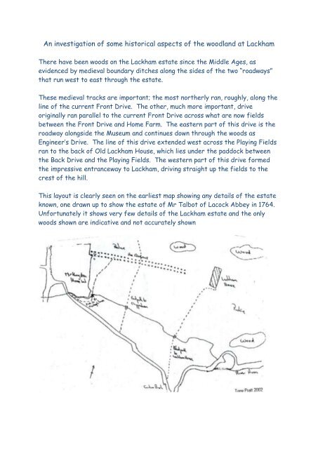
An investigation <strong>of</strong> some historical aspects <strong>of</strong> the woodland at <strong>Lackham</strong><br />
<strong>The</strong>re have been woods on the <strong>Lackham</strong> estate since the Middle Ages, as<br />
evidenced by medieval boundary ditches along the sides <strong>of</strong> the two “roadways”<br />
that run west to east through the estate.<br />
<strong>The</strong>se medieval tracks are important; the most northerly ran, roughly, along the<br />
line <strong>of</strong> the current Front Drive. <strong>The</strong> other, much more important, drive<br />
originally ran parallel to the current Front Drive across what are now fields<br />
between the Front Drive and Home Farm. <strong>The</strong> eastern part <strong>of</strong> this drive is the<br />
roadway alongside the Museum and continues down through the woods as<br />
Engineer’s Drive. <strong>The</strong> line <strong>of</strong> this drive extended west across the Playing Fields<br />
ran to the back <strong>of</strong> Old <strong>Lackham</strong> House, which lies under the paddock between<br />
the Back Drive and the Playing Fields. <strong>The</strong> western part <strong>of</strong> this drive formed<br />
the impressive entranceway to <strong>Lackham</strong>, driving straight up the fields to the<br />
crest <strong>of</strong> the hill.<br />
This layout is clearly seen on the earliest map showing any details <strong>of</strong> the estate<br />
known, one drawn up to show the estate <strong>of</strong> Mr Talbot <strong>of</strong> Lacock Abbey in 1764.<br />
Unfortunately it shows very few details <strong>of</strong> the <strong>Lackham</strong> estate and the only<br />
woods shown are indicative and not accurately shown
Extract from the map made for Mr. Talbot, 1764 1<br />
Luckily a much better map, from <strong>Lackham</strong>’s point <strong>of</strong> view, was made only 9 years<br />
later by Andrews and Drury.<br />
Fig.9 Excerpt from Andrews and Drury’s map 1773<br />
This map clearly shows the same layout <strong>of</strong> woodland as we see today (albeit<br />
today’s woods have been encroached on at the western edge by the complex<br />
that makes up the Walled Garden, Stable Yard and Engineering areas). <strong>The</strong><br />
winding pathways that meander through the woods can still be seen today and<br />
are a feature <strong>of</strong> the 18 th century fashion <strong>of</strong> “<strong>The</strong> Picturesque”, any landscape<br />
avenues made earlier than this would have been the rigidly straight lines <strong>of</strong> the<br />
grand Formal Gardens, such as those seen at Versailles, Vaux and Hampton<br />
Court. It may be that the straight rectilinear grid <strong>of</strong> drives was developed in<br />
the Formal Garden period (roughly from the middle <strong>of</strong> early 17 th to early 18 th<br />
centuries) and that the winding paths were put in during the later 18 th century<br />
but this is speculative as the map based evidence does not exist to prove it one<br />
way or the other.<br />
Within the woodland there are medieval? (probably) marker ditches that<br />
separate out different woodland compartments. <strong>The</strong>se have not yet been<br />
1 Wiltshire and Swindon History Centre, Chippenham (henceforth W&SHC) 244
mapped 2 but it is likely they would show a fairly regular layout, although not<br />
rigidly rectilinear.<br />
A map used for the tithe survey in the 1830’s but probably dated to about 1816<br />
shows very clearly how close together the two medieval trackways are, and that,<br />
at this period, the continuity across the front <strong>of</strong> the house was not in place<br />
Excerpt from c1816 map<br />
<strong>The</strong> layout <strong>of</strong> the woods in the mid nineteenth century is clearly shown on a sale<br />
map dated 1864<br />
2 Could be an interesting project……..
Features shown on this map include the large clearing in the centre <strong>of</strong> the<br />
southern woods. This may be a decorative feature, a sunny glade that could be<br />
reached by following the ornamental Lime Tree Walk alongside the river and the<br />
Pollarded Hornbeam Walk in the north east corner <strong>of</strong> South Wood. Both <strong>of</strong><br />
these Walks are ornamental <strong>features</strong> that are indications that the woodland<br />
was being used, at least in part, as a recreational resource.<br />
<strong>The</strong> basic layout <strong>of</strong> the woods has not changed drastically since then although<br />
much <strong>of</strong> the western half <strong>of</strong> South Wood has been lost to buildings and the<br />
Museum area since 1960<br />
Overview <strong>of</strong> historical <strong>features</strong> <strong>of</strong> <strong>Lackham</strong> <strong>Woods</strong><br />
<br />
<br />
<strong>The</strong> medieval (or at latest 16 th century) boundary ditches down either<br />
side <strong>of</strong> both the main drives – the continuation <strong>of</strong> the Main drive past the<br />
House and Engineer’s Ride.<br />
Within the woodland, for example in North Wood and the central bit,<br />
there are lesser ditches which are certainly compartment boundaries for
coppicing etc. <strong>The</strong>se are more troublesome to date but I see no reason<br />
why they shouldn’t be relict medieval boundaries for the “vill” at <strong>Lackham</strong><br />
<strong>The</strong> coppice itself, although I don’t see any direct evidence for it being<br />
ancient, is probably replants <strong>of</strong> the medieval and Tudor system<br />
<strong>The</strong> winding paths evident on the maps are certainly at least 18 th century<br />
and are part <strong>of</strong> the start <strong>of</strong> the change in use <strong>of</strong> the woods from entirely<br />
functional productive units to being also part <strong>of</strong> the “aesthetic”<br />
attraction <strong>of</strong> the estate, walking through nature as opposed to working<br />
with nature you might say. Obviously the woods were, and indeed<br />
continue to be, both but the balance swings backwards and forwards. In<br />
the 17-18 th centuries it was mostly functional with some leisure, in the<br />
nineteenth much more to do with leisure and today back more towards<br />
production. I think it is not unreasonable to claim that the shooting<br />
interests are leisure in the 19 th early 20 th centuries (it certainly was for<br />
the lord <strong>of</strong> the manor and his / her chums) whereas today the shooting is<br />
productive as the shoot is run in part as a commercial enterprise.( what<br />
do you think?)<br />
<strong>The</strong> “Hornbeam Walk” is late 18 th to mid nineteenth century in date and is<br />
definitely in the area <strong>of</strong> “aesthetic”.<br />
<strong>The</strong> Lime Walk and the broad “ride” that runs from the river north west<br />
to the south edge <strong>of</strong> the Playing Field are both <strong>of</strong> about the same date<br />
(?) and again leisure <strong>features</strong>.<br />
<strong>The</strong> “Glade” area in the South Wood, first clearly evident on maps from<br />
about the mid 1850’s is probably also aesthetic in use.<br />
<strong>The</strong> World War II hardened defence structure (Pill box) in the NE<br />
corner <strong>of</strong> North Wood is one <strong>of</strong> the more recent historical <strong>features</strong> <strong>of</strong><br />
the woodland.<br />
Obviously the flora <strong>of</strong> the woods, with indicator species in both extant<br />
woodland and former woodland areas, such as the Spring Garden area<br />
west <strong>of</strong> the Walled Garden, indicate an ancient woodland being in place<br />
over all <strong>of</strong> the existing woodland area, and even wider<br />
Tony Pratt<br />
Garden Staff and Estate Historian 2013