Download the National Library Magazine - National Library of ...
Download the National Library Magazine - National Library of ...
Download the National Library Magazine - National Library of ...

Create successful ePaper yourself
Turn your PDF publications into a flip-book with our unique Google optimized e-Paper software.
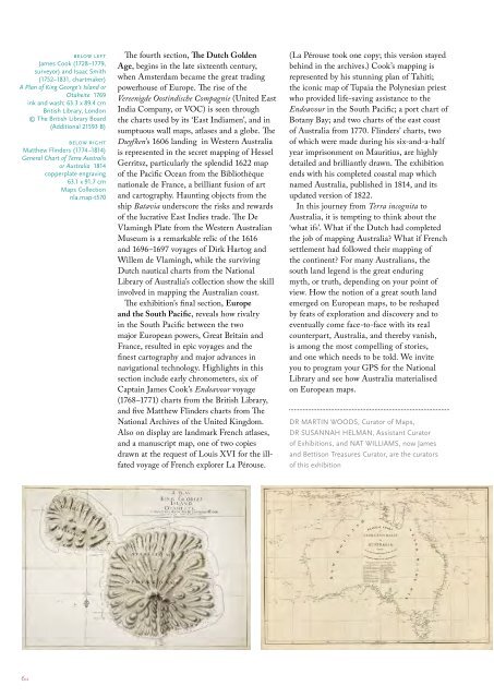
elow left<br />
James Cook (1728–1779,<br />
surveyor) and Isaac Smith<br />
(1752–1831, chartmaker)<br />
A Plan <strong>of</strong> King George’s Island or<br />
Otaheite 1769<br />
ink and wash; 63.3 x 89.4 cm<br />
British <strong>Library</strong>, London<br />
© The British <strong>Library</strong> Board<br />
(Additional 21593 B)<br />
below right<br />
Mat<strong>the</strong>w Flinders (1774–1814)<br />
General Chart <strong>of</strong> Terra Australis<br />
or Australia 1814<br />
copperplate engraving<br />
63.1 x 91.7 cm<br />
Maps Collection<br />
nla.map-t570<br />
The fourth section, The Dutch Golden<br />
Age, begins in <strong>the</strong> late sixteenth century,<br />
when Amsterdam became <strong>the</strong> great trading<br />
powerhouse <strong>of</strong> Europe. The rise <strong>of</strong> <strong>the</strong><br />
Vereenigde Oostindische Compagnie (United East<br />
India Company, or VOC) is seen through<br />
<strong>the</strong> charts used by its ‘East Indiamen’, and in<br />
sumptuous wall maps, atlases and a globe. The<br />
Duyfken’s 1606 landing in Western Australia<br />
is represented in <strong>the</strong> secret mapping <strong>of</strong> Hessel<br />
Gerritsz, particularly <strong>the</strong> splendid 1622 map<br />
<strong>of</strong> <strong>the</strong> Pacific Ocean from <strong>the</strong> Bibliothèque<br />
nationale de France, a brilliant fusion <strong>of</strong> art<br />
and cartography. Haunting objects from <strong>the</strong><br />
ship Batavia underscore <strong>the</strong> risks and rewards<br />
<strong>of</strong> <strong>the</strong> lucrative East Indies trade. The De<br />
Vlamingh Plate from <strong>the</strong> Western Australian<br />
Museum is a remarkable relic <strong>of</strong> <strong>the</strong> 1616<br />
and 1696–1697 voyages <strong>of</strong> Dirk Hartog and<br />
Willem de Vlamingh, while <strong>the</strong> surviving<br />
Dutch nautical charts from <strong>the</strong> <strong>National</strong><br />
<strong>Library</strong> <strong>of</strong> Australia’s collection show <strong>the</strong> skill<br />
involved in mapping <strong>the</strong> Australian coast.<br />
The exhibition’s final section, Europe<br />
and <strong>the</strong> South Pacific, reveals how rivalry<br />
in <strong>the</strong> South Pacific between <strong>the</strong> two<br />
major European powers, Great Britain and<br />
France, resulted in epic voyages and <strong>the</strong><br />
finest cartography and major advances in<br />
navigational technology. Highlights in this<br />
section include early chronometers, six <strong>of</strong><br />
Captain James Cook’s Endeavour voyage<br />
(1768–1771) charts from <strong>the</strong> British <strong>Library</strong>,<br />
and five Mat<strong>the</strong>w Flinders charts from The<br />
<strong>National</strong> Archives <strong>of</strong> <strong>the</strong> United Kingdom.<br />
Also on display are landmark French atlases,<br />
and a manuscript map, one <strong>of</strong> two copies<br />
drawn at <strong>the</strong> request <strong>of</strong> Louis XVI for <strong>the</strong> illfated<br />
voyage <strong>of</strong> French explorer La Pérouse.<br />
(La Pérouse took one copy; this version stayed<br />
behind in <strong>the</strong> archives.) Cook’s mapping is<br />
represented by his stunning plan <strong>of</strong> Tahiti;<br />
<strong>the</strong> iconic map <strong>of</strong> Tupaia <strong>the</strong> Polynesian priest<br />
who provided life-saving assistance to <strong>the</strong><br />
Endeavour in <strong>the</strong> South Pacific; a port chart <strong>of</strong><br />
Botany Bay; and two charts <strong>of</strong> <strong>the</strong> east coast<br />
<strong>of</strong> Australia from 1770. Flinders’ charts, two<br />
<strong>of</strong> which were made during his six-and-a-half<br />
year imprisonment on Mauritius, are highly<br />
detailed and brilliantly drawn. The exhibition<br />
ends with his completed coastal map which<br />
named Australia, published in 1814, and its<br />
updated version <strong>of</strong> 1822.<br />
In this journey from Terra incognita to<br />
Australia, it is tempting to think about <strong>the</strong><br />
‘what ifs’. What if <strong>the</strong> Dutch had completed<br />
<strong>the</strong> job <strong>of</strong> mapping Australia? What if French<br />
settlement had followed <strong>the</strong>ir mapping <strong>of</strong><br />
<strong>the</strong> continent? For many Australians, <strong>the</strong><br />
south land legend is <strong>the</strong> great enduring<br />
myth, or truth, depending on your point <strong>of</strong><br />
view. How <strong>the</strong> notion <strong>of</strong> a great south land<br />
emerged on European maps, to be reshaped<br />
by feats <strong>of</strong> exploration and discovery and to<br />
eventually come face-to-face with its real<br />
counterpart, Australia, and <strong>the</strong>reby vanish,<br />
is among <strong>the</strong> most compelling <strong>of</strong> stories,<br />
and one which needs to be told. We invite<br />
you to program your GPS for <strong>the</strong> <strong>National</strong><br />
<strong>Library</strong> and see how Australia materialised<br />
on European maps.<br />
DR MARTIN WOODS, Curator <strong>of</strong> Maps,<br />
DR SUSANNAH HELMAN, Assistant Curator<br />
<strong>of</strong> Exhibitions, and NAT WILLIAMS, now James<br />
and Bettison Treasures Curator, are <strong>the</strong> curators<br />
<strong>of</strong> this exhibition<br />
6::