Water Cycle Study - March 2010 - North West Leicestershire District ...
Water Cycle Study - March 2010 - North West Leicestershire District ...
Water Cycle Study - March 2010 - North West Leicestershire District ...

You also want an ePaper? Increase the reach of your titles
YUMPU automatically turns print PDFs into web optimized ePapers that Google loves.
Creating the environment for business<br />
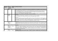
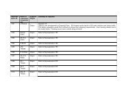
Table 4.1 (continued) Summary of Flooding Sources (SFRA Final Report, Atkins, May 2008)<br />
Source<br />
Canals<br />
Sewers<br />
Location<br />
Minor canal risk of flooding.<br />
Appendix A of the SFRA shows the location of foul and surface water sewer incidents. Within<br />
the context of strategic planning, identification of these hotspots will inform <strong>North</strong> <strong>West</strong><br />
<strong>Leicestershire</strong> <strong>District</strong> Council of areas where increased levels of investment may be required<br />
by developers to improve the hydraulic capacity of the existing sewer system.<br />
Surface water run-off can present a risk of flooding. In urban areas, impermeable surfaces replace the natural<br />
ground surface resulting in increased conveyance of rainfall runoff into drains, rather than naturally infiltrating into<br />
the ground. The rate and volume of rainfall runoff from these areas can increase and exacerbate flooding by<br />
reaching river systems quicker than in a natural environment, and through exceeding the capacity of conventional<br />
piped drainage systems. In many areas, drains are designed for both surface water and foul water, and should these<br />
reach capacity ahead of heavy rainstorms, the risk of sewage flooding can be high.<br />
Most of the <strong>District</strong> is generally rural. In the north and east of the <strong>District</strong> the underlying geology comprises<br />
mudstones that are of low permeability such that runoff rates will naturally be high and infiltration of rainfall will<br />
be low. In the south and west of the <strong>District</strong> sandstones are present, which permit high rates of infiltration and<br />
subsequently lower run-off rates. The overlying soils and gradients are also important in determining run-off and<br />
infiltration. Within urban areas and where drift and soils are made of clay material, runoff rates will potentially be<br />
higher with a risk of surface water flooding.<br />
4.2 <strong>Water</strong> Quality<br />
<strong>Water</strong> quality of rivers, lakes and groundwater is a good indicator of the general health of the water bodies in terms<br />
of their ecology, biodiversity and amenity. The WFD is the principal legislative driver dictating the targets for<br />
surface and groundwater quality and under which actions to achieve compliance are implemented and monitored.<br />
Other EC Directives, such as the Habitats Directive and the Urban Wastewater Treatment Directive also set<br />
objectives for specific designated waters, which contribute to the overall target of achieving good water body status<br />
and WFD compliance by 2015.<br />
4.2.1 Overall <strong>Water</strong> Quality<br />
The Environment Agency has been monitoring the health of all receiving waters (watercourses receiving effluent<br />
discharges) for a number of years through the previous General Quality Assessment (GQA) scheme based on<br />
chemistry, biology and nutrients. In 2007, the monitoring programme changed to align with WFD requirements.<br />
Doc Reg No. 26271c006i2<br />
Page 21<br />
© Entec UK Limited<br />
19 <strong>March</strong> <strong>2010</strong>