Water Cycle Study - March 2010 - North West Leicestershire District ...
Water Cycle Study - March 2010 - North West Leicestershire District ...
Water Cycle Study - March 2010 - North West Leicestershire District ...

Create successful ePaper yourself
Turn your PDF publications into a flip-book with our unique Google optimized e-Paper software.
Creating the environment for business<br />
4.2.3 Groundwater<br />
In the context of the <strong>Water</strong> Framework Directive, the water environment includes rivers, lakes, estuaries,<br />
groundwater and coastal waters out to one nautical mile. For the purposes of river basin management, these waters<br />
are divided into units called water bodies. The quality of water in groundwater bodies is defined by both<br />
quantitative and chemical status in the River Basin Management Plans. The groundwater bodies in the study area<br />
are generally designated as having a good quantitative status, but in the Tame Anker and Mease catchment area the<br />
chemical status is generally poor.<br />
Aquifers that are used for public water supply have designated protection zones around the abstraction source to<br />
prevent pollution of the underlying groundwater. Within <strong>North</strong> <strong>West</strong> <strong>Leicestershire</strong>, source protection zones are<br />
located in Coalville, Whitwick and Measham and its surrounding area, covering the villages of Chilcote, Appleby<br />
Magna and Stretton en le Field.<br />
4.2.4 Designated Sites<br />
The legislative drivers for the water quality are presented in Table 3.1, which includes European legislation to<br />
protect receiving waters and their dependant habitats that are considered particularly sensitive. The sites present in<br />
the study area are presented in Figure 4.5, with tables of their designations in Appendix D.<br />
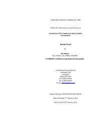
River Mease SAC<br />
The River Mease is a small lowland river designated Special Area of Conservation (SAC) and a Site of Specific<br />
Scientific Interest (SSSI) on account of its vegetation and freshwater fish communities. The current condition of<br />
the SAC is unfavourable. The unfavourable status is primarily related to elevated nutrients, in particular ortho<br />
phosphate. Phosphorous in rivers can be sourced from agricultural sources and from sewerage.<br />
The outcome of a planning appeal for development within the catchment of the Packington wastewater treatment<br />
works is currently awaited. The issue of water quality in the River Mease was a major issue considered at the<br />
inquiry, with the Environment Agency and Natural England providing evidence on the water quality issue of ortho<br />
phosphates in the river (see Section 5.1.1 for more detail). The results of the monitoring of this element are<br />
presented in Figure 4.4 below, taken from the Agency’s proof of evidence at the public inquiry.<br />
The red line in Figure 4.4 represents the target quality of ortho-phosphates of 0.06 mg/l as set by the Habitat’s<br />
Directive. The black triangles represented actual concentrations of ortho phosphate as measured by the<br />
Environment Agency’s routine sampling and monitoring programme. The graph clearly demonstrates that the<br />
ortho phosphate levels are elevated significantly above the desired target value between February 2005 and July<br />
2009.<br />
Doc Reg No. 26271c006i2<br />
Page 27<br />
© Entec UK Limited<br />
19 <strong>March</strong> <strong>2010</strong>