Neighborhood Guide: The Lower East Side - New York Public Library
Neighborhood Guide: The Lower East Side - New York Public Library
Neighborhood Guide: The Lower East Side - New York Public Library

Create successful ePaper yourself
Turn your PDF publications into a flip-book with our unique Google optimized e-Paper software.
: : section 1 : : From Farm to <strong>Neighborhood</strong> : : : : section 1 : : From Farm to <strong>Neighborhood</strong> : :<br />
Though it is hard to imagine,<br />
<strong>New</strong> <strong>York</strong> City was once a<br />
fertile landscape of marshes<br />
and woods with a variety<br />
of wildlife and flora. Native<br />
American populations lived<br />
on the land for many years<br />
before and after it was settled<br />
by Europeans beginning in the<br />
1600s.<br />
<strong>The</strong> first of these immigrant settlers were primarily<br />
the Dutch, whose control was supplanted by the<br />
British in 1664. One of these settlers was Harmanus<br />
Rutgers (his brother, Anthony Rutgers, owned land<br />
west of the Bowery and Broadway). Prior to the<br />
American Revolution, Rutgers Farm stretched for<br />
most of what is now the Seventh Ward, taking in<br />
everything from Division Street to Catherine Street<br />
and from Montgomery Street to the <strong>East</strong> River. After<br />
Harmanus’s death in 1755, the land was mapped into<br />
streets and building lots, but it was not developed<br />
until the early 1800s, when it became a site for tenement<br />
housing. In a section of this very same stretch<br />
of land, from Catherine Street to Market Street and<br />
from Monroe Street to Cherry Street, the city erected<br />
one of its earliest housing complexes, Knickerbocker<br />
Village, in the 1930s (the subject of a later chapter in<br />
this guide). A surviving print of Rutgers Farm from the<br />
1700s provides a striking reference point for the layers<br />
of physical change in the area.<br />
to rent. At the time of their settlement, the German<br />
<strong>Lower</strong> <strong>East</strong> <strong>Side</strong> was known as Kleindeutchland and<br />
was filled with cafés, beer halls, German grocery<br />
stores, and one of the earliest department stores,<br />
Ridley’s, on Grand Street. By the late 1800s, other immigrant<br />
groups from around the world were arriving in<br />
<strong>New</strong> <strong>York</strong> and settling on the <strong>Lower</strong> <strong>East</strong> <strong>Side</strong>. At the<br />
same time, Kleindeutchland was beginning to shrink<br />
as Germans gained more financial and business success<br />
and moved north to other neighborhoods in the<br />
developing city. However, it was a devastating event<br />
that ended the Kleindeutchland era of the <strong>Lower</strong> <strong>East</strong><br />
<strong>Side</strong> for good. This was the burning and sinking of the<br />
General Slocum. On June 15, 1904, the General Slocum,<br />
a ferry carrying passengers from the <strong>Lower</strong> <strong>East</strong> <strong>Side</strong>’s<br />
St. Mark’s Lutheran Church to their annual picnic on<br />
Long Island, caught fire. Hoping to outrun the flames,<br />
the ferry’s captain ordered his crew to speed toward<br />
North Brother Island, only a few miles away, rather<br />
than beach the boat on the shores of the <strong>East</strong> River,<br />
which were closer. His decision, however, proved fatal.<br />
As the flames quickly engulfed the boat, the passengers—mostly<br />
women and children—either jumped<br />
into the water below or succumbed to the fire. A total<br />
of 1,021 people died. <strong>The</strong> captain, who survived, was<br />
convicted of criminal negligence. <strong>The</strong> devastation of<br />
this event rippled through the German community and<br />
hastened the pace of the exodus of German residents<br />
from the <strong>Lower</strong> <strong>East</strong> <strong>Side</strong>. A memorial to this disaster<br />
was erected and still stands in Tompkins Square Park.<br />
<strong>The</strong> following documents each have questions for<br />
interpretation. In addition, you might want to try<br />
some of the suggested activities in the How to Use<br />
This <strong>Guide</strong> section of the resource.<br />
Something to try: Ask students to find the location<br />
of Rutgers Farm on the map accompanying the<br />
print. <strong>The</strong>n look for the Division Street tenements.<br />
You can even chart the location of Knickerbocker<br />
RESOURCES<br />
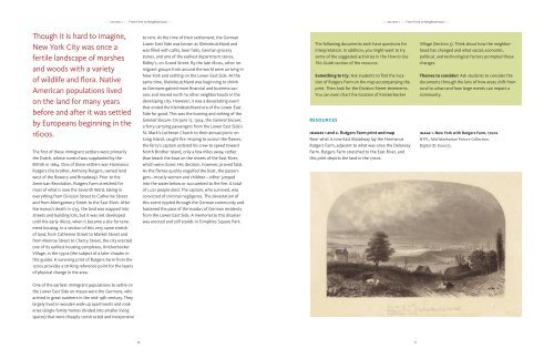
images 1 and 2. Rutgers Farm print and map<br />
Near what is now <strong>East</strong> Broadway lay the Harmanus<br />
Rutgers Farm, adjacent to what was once the Delancey<br />
Farm. Rutgers Farm stretched to the <strong>East</strong> River, and<br />
this print depicts the land in the 1700s.<br />
Village (Section 5). Think about how the neighborhood<br />
has changed and what social, economic,<br />
political, and technological factors prompted these<br />
changes.<br />
<strong>The</strong>mes to consider: Ask students to consider the<br />
documents through the lens of how areas shift from<br />
rural to urban and how large events can impact a<br />
community.<br />
image 1. <strong>New</strong> <strong>York</strong> with Rutgers Farm, 1700s<br />
NYPL, Mid-Manhattan Picture Collection.<br />
Digital ID: 800075.<br />
One of the earliest immigrant populations to settle on<br />
the <strong>Lower</strong> <strong>East</strong> <strong>Side</strong> en masse were the Germans, who<br />
arrived in great numbers in the mid-19th century. <strong>The</strong>y<br />
largely lived in wooden walk-up apartments and rookeries<br />
(single-family homes divided into smaller living<br />
spaces) that were cheaply constructed and inexpensive<br />
10 11