

Project map brochure - NZ Transport Agency
Project map brochure - NZ Transport Agency
Project map brochure - NZ Transport Agency

You also want an ePaper? Increase the reach of your titles
YUMPU automatically turns print PDFs into web optimized ePapers that Google loves.
Roads of national significance<br />
The future of tolling is free-flow<br />
The Tauranga Eastern Link will use an electronic tolling<br />
system to enable you to travel the 23km journey without<br />
having to stop or slow down to pay.<br />
The proposed location of the toll collection point is to be<br />
between Kaituna River and the future Rangiuru Business<br />
Park intersection.<br />
The exact tolling system to be used will be selected closer<br />
to completion of the road.<br />
Roads of national significance<br />
The Government has identified seven essential state<br />
highways that are linked to New Zealand’s economic<br />
prosperity. Called the roads of national significance, the<br />
<strong>NZ</strong> <strong>Transport</strong> <strong>Agency</strong> is charged with delivering these<br />
highway projects.<br />
The Tauranga Eastern Link is a key strategic transport<br />
corridor for the Bay of Plenty region and a highway<br />
recognised by the government as a road of national<br />
significance.<br />
<strong>Project</strong> <strong>map</strong><br />
Tauranga Eastern Link<br />
Map<br />
Stay informed<br />
» Visit www.nzta.govt.nz/tel for the latest news and<br />
construction progress.<br />
» To receive construction and traffic updates delivered<br />
directly to your email inbox, sign up by visiting our website<br />
or emailing us at taurangaeasternlink@nzta.govt.nz<br />
» Speak directly to a member of the project team by visiting<br />
the visitor information centre, 65 Tara Road, Papamoa.<br />
The Tauranga Eastern Link will<br />
deliver the following benefits:<br />
» Safer and easier travel.<br />
» Reduced travel times between Tauranga and Paengaroa.<br />
» More efficient connections for business, industry and<br />
tourism.<br />
» Support regional growth.<br />
» Generate jobs and a flow-on effect into the local<br />
economy in the form of wages and salaries.<br />
Our contact details<br />
free phone 0800 TEL INFO (0800 835 463)<br />
email taurangaeasternlink@nzta.govt.nz<br />
website www.nzta.govt.nz/tel<br />
June 2011
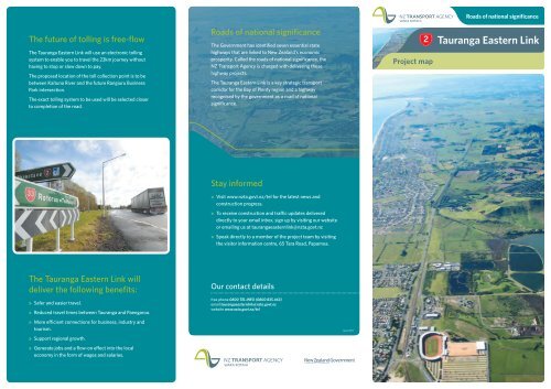
The $455 million Tauranga Eastern Link will be the largest state highway project ever built in the Bay of Plenty.<br />
1. Te Maunga and new residential access lane<br />
Gloucester Road access<br />
Truman Lane<br />
5. Kaituna River Bridge<br />
and Bell Road underpass<br />
Eversham Road access<br />
Residential access lane<br />
Bay Park<br />
7. Maketu Road underpass and<br />
Te Tumu Road realignment<br />
State Highway 29<br />
PAPAMOA<br />
Gordon<br />
Spratt<br />
Reserve<br />
Visitor information<br />
centre and site office<br />
Future Papamoa<br />
East interchange<br />
Lower Kaituna<br />
Wildlife<br />
Management<br />
Reserve<br />
Kaituna Road<br />
(new)<br />
Kaituna Road<br />
(existing)<br />
Domain Road Road<br />
Bayfair<br />
Shopping<br />
Centre<br />
Girven Road<br />
Eversham Rd<br />
Maunganui Road<br />
(State Highway y 2)<br />
TE MAUNGA<br />
State Highway Highway 29<br />
Gloucester Road<br />
Truman Lane<br />
Baypark<br />
Stadium<br />
Manga Mangatawa atawa awa Lane<br />
Gravatt Road<br />
Bruce Road Road<br />
(left in/out in/out only) only)<br />
Kairua Road<br />
Road<br />
(left in/out only) only)<br />
Dom<br />
ma<br />
d<br />
Tara<br />
Rd<br />
d<br />
Welcome Bay<br />
Road<br />
Tara a Road<br />
Road<br />
Statete Highway 2<br />
(current)<br />
Parton arton Road Road<br />
Bell Road<br />
Kaituna River<br />
Pah Road<br />
Future business<br />
park interchange<br />
Proposed Rangiuru<br />
business park<br />
Young Road<br />
ung Road<br />
Te Tumu Tumu Road Road<br />
State Highway 2<br />
(current)<br />
Maketu Road<br />
State Highway 2<br />
State Highway 33<br />
PAENGAROA<br />
Papamoa/ amo<br />
Te Puke exit<br />
TEL on-ramp<br />
Papamoa<br />
Domain Domain Rd Rd<br />
Te e Puke<br />
Tauranga<br />
TEL on-ramp<br />
Paengaroa/Rotorua/Whakatane<br />
Papamoa<br />
a<br />
Tauranga<br />
TEL TEL off-raamp<br />
4. Parton Road overbridge<br />
6. Proposed toll collection point<br />
TE PUKE<br />
2. Mangatawa interchange<br />
NOTE: The illustration and images are indicative of the proposed finished design.<br />
3. Domain Road interchange<br />
8. Paengaroa roundabout<br />
The Bay of Plenty’s largest highway<br />
Expected completion<br />
Construction of the Tauranga Eastern Link is expected to take five to six years,<br />
depending on soil and weather conditions. All going well, it will be open to traffic in 2016.<br />
Construction of the Bay’s largest highway started late<br />
2010. Under the design and construct delivery model,<br />
the Fulton Hogan HEB Construction Alliance decide<br />
when and how the construction is done. With three<br />
million cubic metres of earth to move, and seven bridges<br />
to build, it’s a large scale project to plan and manage.<br />
Section one: Te Maunga to Domain Road<br />
Upgrade 6km of existing highway to four lanes with median barrier.<br />
Key features include:<br />
• widening the existing state highway from Te Maunga to Domain Road<br />
• improving Te Maunga intersection<br />
• new and safer access for properties fronting State Highway 2<br />
• two new interchanges at Mangatawa and Domain Road<br />
• left-in/left-out intersections at Bruce and Kairua Roads.<br />
Section two: Domain Road to Paengaroa junction (SH2/SH33)<br />
Construction of a new 17km highway with four lanes and a median<br />
barrier. Key features include:<br />
• Parton Road overbridge<br />
• 150m four lane bridge over the Kaituna River<br />
• overpasses over Maketu Road and railway line<br />
• roundabout at SH2 and SH33 intersection near Paengaroa.


