

2. Mangatawa catchment consents for earthworks, storm water ...
2. Mangatawa catchment consents for earthworks, storm water ...
2. Mangatawa catchment consents for earthworks, storm water ...
- No tags were found...

Create successful ePaper yourself
Turn your PDF publications into a flip-book with our unique Google optimized e-Paper software.
<strong>Mangatawa</strong> Drain Flood Bypass and TEM<br />
Storm<strong>water</strong> AEE
NZ Transport Agency and Tauranga City Council<br />
<strong>Mangatawa</strong> Drain Flood Bypass and TEM Storm<strong>water</strong> AEE<br />
This report has been prepared <strong>for</strong> the benefit of the NZ Transport Agency (NZTA) and Tauranga City Council<br />
(TCC). No liability is accepted by this company or any employee or sub-consultant of this company with<br />
respect to its use by any other person.<br />
This disclaimer shall apply notwithstanding that the report may be made available to other persons <strong>for</strong> an<br />
application <strong>for</strong> permission or approval or to fulfil a legal requirement.<br />
Quality Assurance Statement<br />
Project Manager: Tm Haig<br />
Prepared by: Michael Seabourne<br />
Reviewed by: Christine Ralph<br />
Approved <strong>for</strong> issue by: Alan Powell<br />
Revision Schedule<br />
Rev.<br />
No<br />
Date Description Prepared by Reviewed by Approved by<br />
Status: Final April 2009<br />
Project Number: 3932036<br />
NZ1-1552092-<strong>Mangatawa</strong> Drain Flood Bypass and TEM Storm<strong>water</strong> AEE
NZ Transport Agency and Tauranga City Council<br />
<strong>Mangatawa</strong> Drain Flood Bypass and TEM Storm<strong>water</strong> AEE<br />
NZ Transport Agency and Tauranga City Council<br />
Contents<br />
1. Introduction........................................................................................................................... 1<br />
1.1 Background .............................................................................................................. 1<br />
1.2 Joint Application ....................................................................................................... 2<br />
1.3 Structure of the Report ............................................................................................. 2<br />
<strong>2.</strong> Background............................................................................................................................ 3<br />
<strong>2.</strong>1 TEM and State Highway <strong>2.</strong>......................................................................................... 3<br />
<strong>2.</strong>2 The <strong>Mangatawa</strong> Drain ............................................................................................... 4<br />
<strong>2.</strong>3 Floods in May 2005 .................................................................................................. 4<br />
<strong>2.</strong>4 Existing Statutory Approvals ..................................................................................... 5<br />
<strong>2.</strong>4.1 TEM Designations previously gained by New Zealand Transport Agency..... 5<br />
<strong>2.</strong>5 Current NZTA Programme......................................................................................... 6<br />
<strong>2.</strong>5.1 TEM Design and Build Contracts................................................................ 6<br />
<strong>2.</strong>6 Current TCC Programme........................................................................................... 6<br />
<strong>2.</strong>6.1 Wairakei Catchment .................................................................................. 6<br />
<strong>2.</strong>6.2 Maranui and <strong>Mangatawa</strong> Catchments......................................................... 7<br />
3. Application Forms .................................................................................................................. 9<br />
4. Activity Status ...................................................................................................................... 38<br />
4.1 Regional Water and Land Plan ................................................................................. 38<br />
4.2 Regional Coastal Plan - Variation of Consent .......................................................... 40<br />
TCC and TEM Storm<strong>water</strong> Treatment Wetland....................................................................... 41<br />
4.3 District Plan Activity Status ..................................................................................... 41<br />
Chapter 24: Transportation Activity and Other Network Utility Rules ....................... 42<br />
Storm<strong>water</strong> Treatment Wetland ............................................................................................ 42<br />
5. Site Description.................................................................................................................... 43<br />
5.1 The Locality ............................................................................................................ 43<br />
5.2 Land Use ................................................................................................................ 44<br />
5.3 Zoning.................................................................................................................... 44<br />
Status: Final April 2009<br />
Project Number: 3932036<br />
NZ1-1552092-<strong>Mangatawa</strong> Drain Flood Bypass and TEM Storm<strong>water</strong> AEE
NZ Transport Agency and Tauranga City Council<br />
<strong>Mangatawa</strong> Drain Flood Bypass and TEM Storm<strong>water</strong> AEE<br />
5.4 State Highway <strong>2.</strong>..................................................................................................... 45<br />
5.5 Social Environment ................................................................................................. 45<br />
5.6 Cultural .................................................................................................................. 45<br />
5.7 Archaeological........................................................................................................ 46<br />
5.7.1 Summary of Results ................................................................................ 46<br />
5.7.2 Archaeological Significance ..................................................................... 46<br />
5.7.3 General Considerations ........................................................................... 46<br />
5.8 Topography............................................................................................................ 47<br />
5.9 Geology.................................................................................................................. 47<br />
5.10 Ground Conditions ................................................................................................. 47<br />
5.11 Contaminated Land................................................................................................. 47<br />
5.12 Land Drainage ........................................................................................................ 48<br />
5.1<strong>2.</strong>1 Catchments............................................................................................. 48<br />
5.1<strong>2.</strong>2 Catchment Hydrology.............................................................................. 49<br />
5.13 Ecology................................................................................................................... 50<br />
5.13.1 <strong>Mangatawa</strong> Drain .................................................................................... 50<br />
5.13.2 Maranui Swale......................................................................................... 51<br />
5.13.3 Storm<strong>water</strong> Treatment Wetland ............................................................... 52<br />
5.13.4 Special Ecological Site - Salt-marsh and Mangrove (SES) .......................... 55<br />
5.13.5 Rangataua Bay......................................................................................... 58<br />
5.13.6 Conclusion.............................................................................................. 59<br />
6. Alternatives Considered ....................................................................................................... 63<br />
6.1 Further Engineering Options Considered................................................................. 64<br />
6.1.1 Outlet and Discharge Points .................................................................... 65<br />
7. Description of the Proposal ..................................................................................................67<br />
7.1 <strong>Mangatawa</strong> Flood Bypass Activities ......................................................................... 67<br />
7.1.1 Increased Drain Storage .......................................................................... 67<br />
7.1.2 Top Spill Bund......................................................................................... 67<br />
7.1.3 Bruce Spill Stop Bank............................................................................... 67<br />
7.1.4 Maintenance Work in Upper <strong>Mangatawa</strong> Drain ......................................... 68<br />
7.1.5 Rail Bridge Embankment Stability ............................................................ 68<br />
7.1.6 Flood Bypass from Maranui to <strong>Mangatawa</strong> ............................................... 69<br />
7.1.7 Sandhurst Culvert ................................................................................... 69<br />
7.1.8 Extension of Maranui Culverts ................................................................. 69<br />
7.1.9 Maranui Swale Deepening........................................................................ 69<br />
7.1.10 Lower <strong>Mangatawa</strong> Drain (from <strong>Mangatawa</strong> Lane to Tauranga Harbour)..... 70<br />
7.1.11 <strong>Mangatawa</strong> Flood Bypass Flood Levels ..................................................... 70<br />
Status: Final April 2009<br />
Project Number: 3932036<br />
NZ1-1552092-<strong>Mangatawa</strong> Drain Flood Bypass and TEM Storm<strong>water</strong> AEE
NZ Transport Agency and Tauranga City Council<br />
<strong>Mangatawa</strong> Drain Flood Bypass and TEM Storm<strong>water</strong> AEE<br />
7.1.12 Storm<strong>water</strong> Treatment Wetland ............................................................... 71<br />
7.2 TEM Roadway Storm<strong>water</strong> ....................................................................................... 73<br />
7.<strong>2.</strong>1 TEM Storm<strong>water</strong> Management Philosophy................................................ 73<br />
7.<strong>2.</strong>2 Swales..................................................................................................... 73<br />
8. Consultation ........................................................................................................................ 75<br />
8.1 Background – Tauranga Eastern Motorway .............................................................. 75<br />
8.1.1 Consultation Objectives .......................................................................... 75<br />
8.2 <strong>Mangatawa</strong> Public Consultation............................................................................... 75<br />
8.3 Directly Affected Landowners.................................................................................. 76<br />
8.4 Individual Landowners ............................................................................................ 76<br />
8.4.1 MPBI........................................................................................................ 76<br />
8.5 Tangata Whenua ..................................................................................................... 78<br />
8.5.1 TEM Project Hui....................................................................................... 78<br />
8.5.2 <strong>Mangatawa</strong> Floodway Application Hui...................................................... 79<br />
8.5.3 Tauranga Eastern Motorway Tangata Whenua Advisory Group ................. 81<br />
9. Assessment of Environmental Effects ................................................................................... 82<br />
9.1 Storm<strong>water</strong> Management ........................................................................................ 82<br />
9.1.1 Water Quantity ........................................................................................ 82<br />
9.1.2 Water Quality .......................................................................................... 83<br />
9.1.3 Fresh<strong>water</strong> Ecology ................................................................................. 86<br />
9.2 Earthworks ............................................................................................................. 89<br />
9.<strong>2.</strong>1 Ecological Effects from Construction ....................................................... 89<br />
9.<strong>2.</strong>2 Noise and Vibration................................................................................. 91<br />
9.<strong>2.</strong>3 Dust........................................................................................................ 91<br />
9.<strong>2.</strong>4 Archaeological Effects from Construction ................................................ 92<br />
9.<strong>2.</strong>5 Hazardous Substances/Contamination/Probability of Risk ....................... 93<br />
9.3 Assessment of Storm<strong>water</strong> and Earthworks Cultural Aspects ................................... 93<br />
10. Statutory Assessment........................................................................................................... 95<br />
10.1 RMA 1991 .............................................................................................................. 95<br />
10.2 Bay of Plenty Regional Policy Statement (RPS) .......................................................... 98<br />
10.3 Operative Regional Water and Land Plan (RWLP) – 1 st December 2008.................... 100<br />
10.4 Bay of Plenty Regional Air Plan .............................................................................. 102<br />
10.5 Regional Coastal Environment Plan Coastal July 2003............................................ 102<br />
10.6 Tauranga District Plan........................................................................................... 103<br />
Status: Final April 2009<br />
Project Number: 3932036<br />
NZ1-1552092-<strong>Mangatawa</strong> Drain Flood Bypass and TEM Storm<strong>water</strong> AEE
NZ Transport Agency and Tauranga City Council<br />
<strong>Mangatawa</strong> Drain Flood Bypass and TEM Storm<strong>water</strong> AEE<br />
10.7 Wairakei Urban Development Comprehensive Storm<strong>water</strong> Consent........................ 106<br />
11. Conclusion......................................................................................................................... 107<br />
11.1 <strong>Mangatawa</strong> Flood Bypass ...................................................................................... 107<br />
11.2 TEM Storm<strong>water</strong> Management............................................................................... 107<br />
11.3 Earthworks ........................................................................................................... 108<br />
11.4 Statutory Conclusion............................................................................................. 108<br />
List of Figures<br />
Figure 1: TEM Layout......................................................................................................................3<br />
Figure 2: Approximate Location of Proposed Works......................................................................43<br />
Figure 3 Positions of Sampling Stations within the Storm<strong>water</strong> Treatment Wetland Area.................55<br />
Status: Final April 2009<br />
Project Number: 3932036<br />
NZ1-1552092-<strong>Mangatawa</strong> Drain Flood Bypass and TEM Storm<strong>water</strong> AEE
NZ Transport Agency and Tauranga City Council<br />
<strong>Mangatawa</strong> Drain Flood Bypass and TEM Storm<strong>water</strong> AEE<br />
List of Tables<br />
Table 1: Regional Consents required and ownership status of each consent .................................38<br />
Table 2: Regional Coastal Environmental Plan Consents Required and Ownership Status of each<br />
Consent ................................................................................................................................41<br />
Table 3: TCC District Plan General Natural Resource Rules - Maintaining Biodiversity and Protecting<br />
Ecosystems ...........................................................................................................................41<br />
Table 4: District Consents Required .............................................................................................42<br />
Table 5: Rangataua Bay Catchment Sediment Quality Results........................................................51<br />
Table 6: Species of Birds Observed utilising the wetland and their Principal Habitats ....................54<br />
Table 7: Sampling Site Locations ..................................................................................................57<br />
Table 8: Results of Rangataua Bay Sediment Quality Analyses.......................................................58<br />
Table 9: Summary of Ecological Characteristics ............................................................................60<br />
Table 10: Hydraulic Results 1% AEP ..............................................................................................71<br />
Table 11: Storm<strong>water</strong> Treatment Requirement..............................................................................72<br />
Table 12: Summary of Issues Raised.............................................................................................77<br />
Table 13: Contaminant Discharge Summary ..................................................................................85<br />
Table 14: Maximum Permitted Ground Vibration Levels................................................................91<br />
Appendices<br />
Appendix 1 – Drawing 3932036 ck301 Rev C<br />
Appendix 2 – Extract from the Tauranga District Plan: Special Ecological Site 13<br />
Appendix 3 – Drawing 3932036 ck119 Rev F<br />
Appendix 4 – Drawings 3932036 ck073 Rev G, ck074 Rev E, ck075 Rev F<br />
Appendix 5 – Bioresearches Report: Ecological Features of some Habitats within Rangataua Bay<br />
Catchment<br />
Appendix 6 – Ngaiterangi Cultural Impact Assessment<br />
Appendix 7 – Archaeological Assessment: Te Maunga to Domain Road, Archaeology BOP<br />
Appendix 8 – Hydraulic Modelling: <strong>Mangatawa</strong> Drain/Maranui Swale – Mitigation Options<br />
Appendix 9 – Drawings 3932036 ck143 Rev C, ck144 Rev E, ck145 Rev E, ck146 Rev E, ck473<br />
Rev A<br />
Appendix 10 – Drawings 3932036 ck460 Rev A, ck461 Rev A, ck462 Rev A, ck467 Rev A, ck468<br />
Rev A, ck469 Rev A<br />
Appendix 11 – Drawing 3932036 ck431 Rev B<br />
Appendix 12 – Drawing 3932036 ck227 Rev D<br />
Appendix 13 – Example Erosion and Sediment Control Plan<br />
Appendix 14 – Regional Water and Land Plan Activity Status, Rules, Policies and Objectives<br />
Appendix 15 – Legal Descriptions of Land Parcels Affected by Construction<br />
Appendix 16 – Existing TCC Discharge Consent Nº 60061<br />
Status: Final April 2009<br />
Project Number: 3932036<br />
NZ1-1552092-<strong>Mangatawa</strong> Drain Flood Bypass and TEM Storm<strong>water</strong> AEE
NZ Transport Agency and Tauranga City Council<br />
<strong>Mangatawa</strong> Drain Flood Bypass and TEM Storm<strong>water</strong> AEE<br />
1. Introduction<br />
This report seeks consent <strong>for</strong> the proposed <strong>storm</strong><strong>water</strong> management activities resulting from the<br />
construction of the Tauranga Eastern Motorway (TEM) and consent <strong>for</strong> activities resulting from Tauranga City<br />
Councils desire to address flooding issues in the <strong>Mangatawa</strong> <strong>catchment</strong>.<br />
Applying <strong>for</strong> The Environment Bay of Plenty <strong>consents</strong> jointly allows the New Zealand Transport Agency (NZTA)<br />
and Tauranga City Council (TCC) to develop a solution that addressed a complex <strong>storm</strong><strong>water</strong> management<br />
issue in an efficient manner. This assessment of environmental effects there<strong>for</strong>e considers the effects of all<br />
the activities related to this project including construction.<br />
In addition the proposal also requires District Council <strong>consents</strong> related to the proposed alteration to the<br />
<strong>storm</strong><strong>water</strong> treatment pond including vegetation clearance, <strong>earthworks</strong> and discharge to the adjacent Special<br />
Ecological Site. The bundle of regional resource <strong>consents</strong> sought is divided in the following way:<br />
• NZTA permit holder <strong>for</strong> construction aspects;<br />
• TCC permit holder <strong>for</strong> long term elements particularly discharges; and<br />
• The District Council land use consent will run with the land on which the treatment pond is placed.<br />
1.1 Background<br />
NZTA is planning to build the TEM, as part of providing transport infrastructure <strong>for</strong> the ongoing growth of<br />
Tauranga and the Bay of Plenty. In November 2008 the NZTA applied to the Regional Council <strong>for</strong> <strong>consents</strong> <strong>for</strong><br />
<strong>earthworks</strong>, <strong>water</strong> take, bridging the Kaituna River and <strong>storm</strong><strong>water</strong> management excluding this <strong>catchment</strong>.<br />
The Hearing was completed on the 18th of December 2008 and a decision has been received.<br />
TCC manages the <strong>storm</strong><strong>water</strong> system in urban Papamoa, and needs to reduce the frequency and magnitude<br />
of spills from the Papamoa Hills and <strong>Mangatawa</strong> Drain into the Papamoa urban area, where there would<br />
otherwise be a risk of inundation of many buildings in large floods.<br />
This application seeks consent to manage the <strong>storm</strong><strong>water</strong> derived from the proposed motorway. NZTA and<br />
TCC are working together to improve the reliability of the route by reducing the frequency of flood overflows<br />
of State Highway 2 (SH2) from the Papamoa Hills and the <strong>Mangatawa</strong> Drain.<br />
Beca has been working with both NZTA and TCC, investigating options <strong>for</strong> reducing the frequency and<br />
magnitude of spills from the <strong>Mangatawa</strong> Drain. As this work has progressed, various options have been<br />
considered and preferred options refined and modelled to confirm their per<strong>for</strong>mance.<br />
Status: Final Page 1 April 2009<br />
Project Number: 3932036<br />
NZ1-1552092-<strong>Mangatawa</strong> Drain Flood Bypass and TEM Storm<strong>water</strong> AEE
NZ Transport Agency and Tauranga City Council<br />
<strong>Mangatawa</strong> Drain Flood Bypass and TEM Storm<strong>water</strong> AEE<br />
1.2 Joint Application<br />
This report will assess the combined effects of this project. The various <strong>consents</strong> required need to be held<br />
separately by either NZTA or TCC <strong>for</strong> the purposes of clearly assigning responsibilities <strong>for</strong> the effects of these<br />
activities. The consent requirements are split between Tauranga City Council and the New Zealand Transport<br />
Agency. It is important to understand that in the issuing of any consent, the Regional Council will be<br />
assigning the responsibility <strong>for</strong> the effects of the activities related to those <strong>consents</strong> to either NZTA or TCC.<br />
The split has been decided and agreed upon by both the organisations applying <strong>for</strong> <strong>consents</strong>.<br />
1.3 Structure of the Report<br />
The key sections of this report are the description of the proposal which is found in Section 7 and the<br />
assessment of the environmental effects in Section 9.<br />
Status: Final Page 2 April 2009<br />
Project Number: 3932036<br />
NZ1-1552092-<strong>Mangatawa</strong> Drain Flood Bypass and TEM Storm<strong>water</strong> AEE
NZ Transport Agency and Tauranga City Council<br />
<strong>Mangatawa</strong> Drain Flood Bypass and TEM Storm<strong>water</strong> AEE<br />
<strong>2.</strong> Background<br />
<strong>2.</strong>1 TEM and State Highway 2<br />
SH2 is the major road access to Tauranga from the south east – Te Puke, Rotorua, Whakatane, Opotiki,<br />
Gisborne. SH2 at this location is categorised as a national function State highway by the NZTA, based on<br />
traffic flows, vehicle composition and the nature of destinations it connects with. It is the main route <strong>for</strong><br />
heavy commercial vehicles heading to the Port of Tauranga from Rotorua and the Eastern Bay of Plenty,<br />
connecting the economically important central plateau <strong>for</strong>estry industry with the export port of Tauranga.<br />
The NZTA is responsible <strong>for</strong> the TEM and this is a key component of the Tauranga Eastern Transport Corridor.<br />
The Tauranga Eastern Corridor is the transportation network required to service the existing and predicted<br />
inter-regional traffic as well as the urban growth of Papamoa East. Papamoa East is the largest growth area<br />
of the Western Bay of Plenty sub-regional SmartGrowth strategy. The attached Figure 1 shows the layout of<br />
the TEM in relation to the SmartGrowth land use areas <strong>for</strong> the eastern corridor.<br />
Figure 1: TEM Layout<br />
Status: Final Page 3 April 2009<br />
Project Number: 3932036<br />
NZ1-1552092-<strong>Mangatawa</strong> Drain Flood Bypass and TEM Storm<strong>water</strong> AEE
NZ Transport Agency and Tauranga City Council<br />
<strong>Mangatawa</strong> Drain Flood Bypass and TEM Storm<strong>water</strong> AEE<br />
The urban growth area of Papamoa is predicted to become a city the size of Nelson (40,000 pop.) by 2050. A<br />
large industrial park is being planned inland from Papamoa East. These developments are designed to<br />
provide <strong>for</strong> residents to live, work and play in the area, reducing commuter travel, but there is still a need <strong>for</strong><br />
additional capacity on the inter-regional corridor.<br />
Currently, traffic volumes on SH2 are up to approximately 21,000 vehicles a day, and the road has a high<br />
crash rate. The New Zealand Road Assessment Programme (KiwiRAP) has ranked this section of SH2 between<br />
Te Maunga and Paengaroa as having the second highest number of fatal and serious injury crashes per<br />
kilometre of State highway in New Zealand.<br />
Travel times are constrained, with limited capacity <strong>for</strong> growth. Traffic through Te Puke’s central business<br />
district is also heavy, and conflicts with local traffic causing safety concerns and an increase in waiting times<br />
at intersections. There are safety concerns at the Waitangi Township to the east of Te Puke.<br />
NZTA has the statutory objective under the Land Transport Management Act (2003) to ‘operate the State<br />
highway system in a way that contributes to an integrated, safe, responsive and sustainable land transport<br />
system’. The construction of the TEM as part of the Tauranga Eastern Corridor achieves this objective.<br />
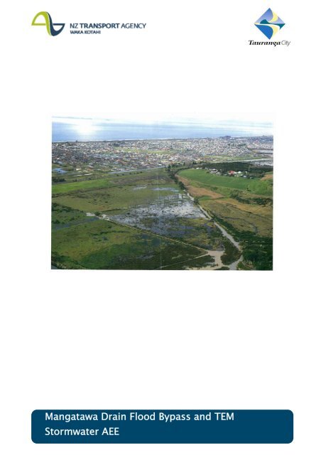
<strong>2.</strong>2 The <strong>Mangatawa</strong> Drain<br />
Tauranga City Council is responsible <strong>for</strong> managing <strong>storm</strong><strong>water</strong> so that property and people are protected<br />
from flood damage, and to minimise adverse effects on the harbour and <strong>water</strong>ways from <strong>storm</strong><strong>water</strong> run-off.<br />
The flooding issue that Council is seeking to resolve is historically associated with the spills across the State<br />
highway from the <strong>Mangatawa</strong> Drain.<br />
The <strong>Mangatawa</strong> Drain was constructed many years ago, reportedly when the railway was built along the route<br />
parallel to what is now SH<strong>2.</strong> The purpose of the drain was to divert flow that previously flowed north into<br />
what was at the time farm land but is now Papamoa urban area.<br />
The <strong>Mangatawa</strong> Drain is about 2,500m long where it is alongside the proposed TEM. The drain is a<br />
vegetated, earth lined channel that is tightly constrained between the railway (to the south) and the motorway<br />
(to the north). There is some uncertainty as to who owns the land and is responsible <strong>for</strong> its maintenance,<br />
although in the past Tauranga City Council has undertaken maintenance. It is predominantly on railway land<br />
and partly on road reserve.<br />
In larger flood events, excess flow spills north across the State highway at two locations into the Papamoa<br />
urban area. The two locations are identified in this report as “Top Spill”, located near Kairua Road and “Bruce<br />
Road Spill”, located just west of Bruce Road (although the spill covers several hundred metres of highway in<br />
the general vicinity of Bruce Road).<br />
<strong>2.</strong>3 Floods in May 2005<br />
In the 18 May 2005 <strong>storm</strong> extensive ponding occurred in the Papamoa area. The <strong>Mangatawa</strong> Drain alongside<br />
the motorway overflowed at two locations. Opus was initially appointed by TCC to undertake investigations<br />
Status: Final Page 4 April 2009<br />
Project Number: 3932036<br />
NZ1-1552092-<strong>Mangatawa</strong> Drain Flood Bypass and TEM Storm<strong>water</strong> AEE
NZ Transport Agency and Tauranga City Council<br />
<strong>Mangatawa</strong> Drain Flood Bypass and TEM Storm<strong>water</strong> AEE<br />
into the drain per<strong>for</strong>mance. They produced three reports 1 and the last was after the May 2005 floods. As part<br />
of their work a MIKE11 hydraulic model was built. New Zealand Transport Agency (NZTA) has been working<br />
with TCC to find a solution which will avoid or at least reduce overflows. The aim <strong>for</strong> NZTA was to avoid if<br />
practicable the 1% annual exceedance probability (AEP) <strong>storm</strong> event overtopping and overflowing the<br />
motorway, while TCC’s aim was to reduce the volume of <strong>water</strong> that would enter the Papamoa <strong>catchment</strong> areas<br />
(Maranui Swale and the Wairakei Stream) such that the design flood level <strong>for</strong> Papamoa of 4.5m RL (Moturiki<br />
Datum), as defined in the District Plan, was not exceeded in the 2% AEP <strong>storm</strong> event. Beca was appointed to<br />
adopt the Opus hydraulic model and undertake further modelling and engineering work to investigate<br />
mitigation options, as an extension to the work they were carrying out <strong>for</strong> NZTA on the TEM.<br />
<strong>2.</strong>4 Existing Statutory Approvals<br />
Currently there are no resource <strong>consents</strong> <strong>for</strong> the management of <strong>storm</strong><strong>water</strong> generated by State Highway 2 or<br />
<strong>for</strong> the <strong>Mangatawa</strong> drain discharge to the Tauranga Harbour. However the <strong>Mangatawa</strong> Drain is defined as<br />
Land Drainage canal in the Regional Water and Land Plan 2 .<br />
The TCC treatment wetland that receives <strong>storm</strong><strong>water</strong> from the Maranui <strong>catchment</strong> has consent <strong>for</strong> discharge<br />
which needs to be varied as part of this application.<br />
The over spill into the Wairakei <strong>catchment</strong> is currently covered by the Wairakei Catchment comprehensive<br />
consent which is currently subject to appeal.<br />
<strong>2.</strong>4.1 TEM Designations previously gained by New Zealand Transport Agency<br />
The designated corridor <strong>for</strong> the motorway has been in place since 2004 and was designated in four parts. It<br />
consists of designations <strong>for</strong>:<br />
• Te Maunga Four Laning<br />
• Te Maunga Service Roads<br />
• Sandhurst Interchange<br />
• Tauranga Eastern Arterial.<br />
The designations are now collectively referred to as the TEM. The designations that relate to this project area<br />
are Te Maunga four laning and Sandhurst Interchange.<br />
1 <strong>Mangatawa</strong> Drain Flood Capacity, September 2000; <strong>Mangatawa</strong> Drain Flood Capacity: Supplementary Report, July 2001;<br />
and <strong>Mangatawa</strong> Drain Flood Assessment, 29 November 2006; all produced by Opus International Consultants Ltd<br />
2 RWLP Dec 2002, Definitions Chapter, Pg 436. Land Drainage Canal.<br />
Status: Final Page 5 April 2009<br />
Project Number: 3932036<br />
NZ1-1552092-<strong>Mangatawa</strong> Drain Flood Bypass and TEM Storm<strong>water</strong> AEE
NZ Transport Agency and Tauranga City Council<br />
<strong>Mangatawa</strong> Drain Flood Bypass and TEM Storm<strong>water</strong> AEE<br />
<strong>2.</strong>5 Current NZTA Programme<br />
Work has progressed since the corridor was designated. The design of the TEM has advanced to allow NZTA<br />
to understand the potential effects and to apply <strong>for</strong> Resource Consents related to the construction of the<br />
TEM. The next step is to develop Specimen Design and Principal’s Requirements to be used in a contract<br />
specification to go to tender with. It is anticipated that if Resource Consents are gained and funding<br />
confirmed, tendering may occur in 2009 with a possible construction start in 2010.<br />
<strong>2.</strong>5.1 TEM Design and Build Contracts<br />
For this project a design and build contract will be used, similar to that employed in the Harbour Link Project<br />
in Tauranga. A design and build contract is structured to encourage innovation and cost saving in the<br />
construction of the project. It works by establishing in contract documentation the environmental and<br />
engineering outcomes and per<strong>for</strong>mance criteria <strong>for</strong> the proposed project. These criteria <strong>for</strong>m the limits in<br />
which the contractor must per<strong>for</strong>m but allows the contractor to use their experience to suggest new and<br />
innovative methods <strong>for</strong> achieving the same outcome. It gives the necessary certainty and flexibility to the<br />
process so that the environmental, engineering and economic outcomes can be achieved whilst allowing cost<br />
savings to be made.<br />
The consent process will set the environmental bottom lines <strong>for</strong> this project that the contractor will be<br />
required to adhere to.<br />
<strong>2.</strong>6 Current TCC Programme<br />
Territorial authorities in the Bay of Plenty Region are required to prepare Comprehensive Storm<strong>water</strong><br />
Consents and Management Plans <strong>for</strong> existing urban areas and areas identified <strong>for</strong> future development. The<br />
Regional Storm<strong>water</strong> Strategy has identified 11 comprehensive <strong>catchment</strong>s in Tauranga City each requiring a<br />
consent with lodgement dates from 2006 through to 2010. TCC has applied <strong>for</strong> the first of these<br />
comprehensive <strong>catchment</strong> <strong>consents</strong> (<strong>for</strong> Papamoa/Wairakei Catchment discussed in clause <strong>2.</strong>6.1 <strong>2.</strong>6.2 below)<br />
and is currently working with Environment BOP to review the number of comprehensive <strong>catchment</strong>s and<br />
prepare a revised programme <strong>for</strong> lodging the consent applications.<br />
<strong>2.</strong>6.1 Wairakei Catchment<br />
An application <strong>for</strong> the Papamoa/Wairakei Comprehensive Catchment was lodged with Environment BOP in<br />
2006 and is being processed in conjunction with the Papamoa East (Wairakei) Plan Change. The application<br />
has been required to consider not only the current urban area but the full urbanization of the Wairakei and Te<br />
Tumu areas over the next 50 years.<br />
The key issue has been flood management in a <strong>catchment</strong> with a limited outlet to the ocean. The long term<br />
proposal is a high level outlet to the Kaituna River to be constructed in conjunction with the commencement<br />
of the development of the Te Tumu area around 2021. In order to manage high winter <strong>water</strong> levels in the<br />
existing rural land in Te Tumu in the interim pumping excess <strong>water</strong> to the Kaituna is proposed.<br />
Status: Final Page 6 April 2009<br />
Project Number: 3932036<br />
NZ1-1552092-<strong>Mangatawa</strong> Drain Flood Bypass and TEM Storm<strong>water</strong> AEE
NZ Transport Agency and Tauranga City Council<br />
<strong>Mangatawa</strong> Drain Flood Bypass and TEM Storm<strong>water</strong> AEE<br />
While the plan change appeals have not yet been entirely resolved, the majority of the plan change has been<br />
accepted and is expected to be resolved in the near future. Key to this application is that spills in to the<br />
Wairakei <strong>catchment</strong> from the <strong>Mangatawa</strong> <strong>catchment</strong> across the state highway have been planned and<br />
accommodated in this comprehensive consent. This design level or amount of flooding has influenced the<br />
design of the <strong>Mangatawa</strong> Drain flood way structures that will be described further in this report.<br />
<strong>2.</strong>6.2 Maranui and <strong>Mangatawa</strong> Catchments<br />
For the purposes of this application two <strong>storm</strong><strong>water</strong> <strong>catchment</strong>s; the <strong>Mangatawa</strong> and Maranui are affected by<br />
the Tauranga Eastern Motorway (TEM) and the <strong>Mangatawa</strong> Drain Flood Bypass Structures. A central issue in<br />
these <strong>catchment</strong>s and <strong>for</strong> the TEM project is the flooding across the State highway and subsequently the<br />
effects of flooding in the Maranui sub <strong>catchment</strong> and Wairakei <strong>catchment</strong>.<br />
Status: Final Page 7 April 2009<br />
Project Number: 3932036<br />
NZ1-1552092-<strong>Mangatawa</strong> Drain Flood Bypass and TEM Storm<strong>water</strong> AEE
NZ Transport Agency and Tauranga City Council<br />
<strong>Mangatawa</strong> Drain Flood Bypass and TEM Storm<strong>water</strong> AEE<br />
3. Application Forms<br />
See notes to applicant (last pages of <strong>for</strong>m) be<strong>for</strong>e<br />
proceeding with application <strong>for</strong>m.<br />
Pursuant to section 88 of the Resource Management Act 1991, the undersigned hereby<br />
makes application <strong>for</strong> resource consent(s).<br />
1 Full name of applicant(s):<br />
This is a joint application – Refer to Table 1 <strong>for</strong> permit holder <strong>for</strong> each consent<br />
Company Name:<br />
New Zealand Transport<br />
Agency<br />
Tauranga City Council<br />
Contact Person: Kevin Reid Graeme Jelley<br />
Postal Address:<br />
PO Box 430, Seventh<br />
Avenue, Tauranga 3140, NZ<br />
91 Willow Street, Private Bag<br />
12022, Tauranga 3110, NZ<br />
Business phone: 07 9276009 07 577 7000<br />
Facsimile number: 07 578 2909 07 571 8917<br />
Email: kevin.reid@nzta.govt.nz graeme.jelley@tauranga.govt.nz<br />
2 Details of consultant<br />
Status: Final Page 9 April 2009<br />
Project Number: 3932036<br />
NZ1-1552092-<strong>Mangatawa</strong> Drain Flood Bypass and TEM Storm<strong>water</strong> AEE
NZ Transport Agency and Tauranga City Council<br />
<strong>Mangatawa</strong> Drain Flood Bypass and TEM Storm<strong>water</strong> AEE<br />
Company Name:<br />
Contact person:<br />
Postal address:<br />
Beca Infrastructure Limited<br />
Christine Ralph / Mike Seabourne<br />
32 Harington St, PO Box 903, Tauranga<br />
Business phone: 07 578 0896<br />
Email:<br />
christine.ralph@beca.com, michael.seabourne@beca.com<br />
All correspondence (including invoices <strong>for</strong> charges) relating to this application(s) should be<br />
sent to:<br />
Applicant:<br />
Consultant:<br />
3 Name and address of owner/occupier of the site relating to application<br />
The legal descriptions of the site are contained in Appendix 15<br />
4 Consent(s) being applied <strong>for</strong> from Environment Bay of Plenty:<br />
Land use<br />
Form 1<br />
Beds of lakes and rivers (use, place, alter or remove structure in river,<br />
stream or lake; disturb bed of river, stream or lake (excluding shingle<br />
extraction); deposit substance in on or under bed of river, stream or<br />
lake).<br />
Form 2 Land disturbing activities (<strong>earthworks</strong>, quarrying, vegetation clearance /<br />
harvesting / burning)<br />
Form 3<br />
Shingle extraction<br />
Water (including coastal)<br />
Form 4A<br />
Form 4B<br />
Form 5<br />
Form 6<br />
Take surface <strong>water</strong> (includes intake structure)<br />
Take ground<strong>water</strong><br />
Dam/divert/use <strong>water</strong><br />
Geothermal - take and discharge<br />
Discharge (including coastal)<br />
Form 7<br />
Form 8<br />
Form 9<br />
Discharge contaminant to air<br />
Discharge contaminant or <strong>water</strong> to <strong>water</strong><br />
Discharge contaminant to land<br />
Status: Final Page 10 April 2009<br />
Project Number: 3932036<br />
NZ1-1552092-<strong>Mangatawa</strong> Drain Flood Bypass and TEM Storm<strong>water</strong> AEE
NZ Transport Agency and Tauranga City Council<br />
<strong>Mangatawa</strong> Drain Flood Bypass and TEM Storm<strong>water</strong> AEE<br />
Form 10<br />
Form 11<br />
Onsite effluent discharge<br />
Discharge farm dairy effluent<br />
Coastal (see point 4 of in<strong>for</strong>mation sheet <strong>for</strong> explanation of the coastal marine area).<br />
Form 12<br />
5 Location description of activity:<br />
General (occupancy; disturb <strong>for</strong>eshore or seabed; plant <strong>for</strong>eshore or<br />
seabed; deposit substance, remove natural material, reclaim or drain;<br />
place, remove or alter structure).<br />
On or generally about the State Highway 2 between the end of Truman Lane and Domain<br />
Road. This includes lands owned by <strong>Mangatawa</strong> Papamoa Blocks Incorporated near or<br />
about the <strong>Mangatawa</strong> Drain to the Tauranga City Council Storm<strong>water</strong> Wetland.<br />
Site plan<br />
Please provide a site plan showing any works relating to the proposal, area surrounding the<br />
site including the names of current owners and occupiers of adjoining property. A lot map<br />
from the district council will assist in identifying potentially affected parties.<br />
• See description of the environment provided in application<br />
6 In which district is the activity located:<br />
Tauranga District<br />
Do you also require resource consent(s) from a district council? Yes No<br />
Type of consent required:<br />
• Significant amounts of <strong>earthworks</strong> and vegetation removal are required as part of the<br />
proposal. These activities are non complying activities subject to Rule 14.1 (b) and (c) of<br />
the Tauranga District Plan<br />
• Storm<strong>water</strong> detention ponds and associated <strong>earthworks</strong> and structures under Table 24-1<br />
in the Industrial Business Zone are controlled activities.<br />
Have these been applied <strong>for</strong>?<br />
• These activities will be applied <strong>for</strong> as part of this application<br />
7 Refer to relevant activity <strong>for</strong>m.<br />
• Form 1, Form 2, Form 5, Form 8, Form 9<br />
8 Is this application to replace an existing or expired consent?<br />
Yes<br />
9 Duration of consent<br />
No<br />
• Please see Table 1 <strong>for</strong> <strong>consents</strong> being applied <strong>for</strong> and duration of those <strong>consents</strong>.<br />
10 DEPOSIT FEE<br />
A deposit fee of $774.00 (including GST) is payable with this application. A GST invoice<br />
marked ‘PAID’ will be issued on receipt of payment. Processing of the application will not<br />
Status: Final Page 11 April 2009<br />
Project Number: 3932036<br />
NZ1-1552092-<strong>Mangatawa</strong> Drain Flood Bypass and TEM Storm<strong>water</strong> AEE
NZ Transport Agency and Tauranga City Council<br />
<strong>Mangatawa</strong> Drain Flood Bypass and TEM Storm<strong>water</strong> AEE<br />
begin until the deposit fee has been paid. Additional charges are usually incurred <strong>for</strong> the<br />
majority of <strong>consents</strong> that are not minor. Staff can give an indicated range of expected costs.<br />
Important Note<br />
In<strong>for</strong>mation Privacy Issues<br />
The in<strong>for</strong>mation you provide in this application is regarded as official in<strong>for</strong>mation. It is<br />
required under the provisions of the Resource Management Act 1991 to process this<br />
application and to assist in the management of the regions natural and physical<br />
resources.<br />
The in<strong>for</strong>mation will be held by Environment Bay of Plenty, Quay Street, Whakatane.<br />
This in<strong>for</strong>mation is subject to the provisions of the Local Government Official<br />
In<strong>for</strong>mation and Meetings Act 1987 and the Privacy Act 1993.<br />
Failure to provide this in<strong>for</strong>mation will mean that Environment Bay of Plenty will be<br />
unable to process your application.<br />
I have read and understand all of the in<strong>for</strong>mation contained on this application <strong>for</strong>m<br />
including the requirement to pay additional costs that will be itemised.<br />
Signature ______________________________________ Date<br />
_______________________<br />
Signature ______________________________________ Date<br />
_______________________<br />
Status: Final Page 12 April 2009<br />
Project Number: 3932036<br />
NZ1-1552092-<strong>Mangatawa</strong> Drain Flood Bypass and TEM Storm<strong>water</strong> AEE
NZ Transport Agency and Tauranga City Council<br />
<strong>Mangatawa</strong> Drain Flood Bypass and TEM Storm<strong>water</strong> AEE<br />
Form 1<br />
Beds of lakes and rivers<br />
Question 7<br />
Assessment of effects on the environment (AEE)<br />
Section 88 of the Resource Management Act 1991 requires all applications <strong>for</strong><br />
resource <strong>consents</strong> to include an assessment of the actual or potential effects that the<br />
proposed activity may have on the environment and the ways in which any adverse<br />
effects can be mitigated. The Fourth Schedule of the Act lists the matters that should<br />
be included in such assessments and a summary is printed on the back of the<br />
application <strong>for</strong>m.<br />
You must fully complete this section or your application cannot be processed.<br />
The in<strong>for</strong>mation you supply should be detailed according to the scale, scope and<br />
effects of the proposed activity.<br />
Applicants <strong>for</strong> small scale proposals having minor effects should be able to supply<br />
sufficient in<strong>for</strong>mation by filling in the spaces provided. More complex proposals with<br />
more significant effects will need to address the following matters (in accordance with<br />
the Fourth Schedule) as a separate document.<br />
If the AEE is presented in the <strong>for</strong>mat of a report, it must address the following matters,<br />
if appropriate.<br />
If you are unsure how to complete this section please contact an environmental<br />
<strong>consents</strong> officer at Environment Bay of Plenty.<br />
1 Description of activity (tick appropriate box)<br />
Use erect / reconstruct / place / alter / extend / remove or demolish any structure or<br />
part of any structure in, on, under, or over the bed.<br />
Excavate, drill, tunnel, or otherwise disturb the bed<br />
Introduce or plant any plant or any part of any plant (whether exotic or indigenous) in,<br />
on, or under the bed<br />
Deposit any substance in, on, or under the bed<br />
Reclaim or drain the bed<br />
Other<br />
Please describe the proposed activity in detail (dimensions, purpose, materials to be used,<br />
reason <strong>for</strong> the works)<br />
See application<br />
Status: Final Page 13 April 2009<br />
Project Number: 3932036<br />
NZ1-1552092-<strong>Mangatawa</strong> Drain Flood Bypass and TEM Storm<strong>water</strong> AEE
NZ Transport Agency and Tauranga City Council<br />
<strong>Mangatawa</strong> Drain Flood Bypass and TEM Storm<strong>water</strong> AEE<br />
Please provide:<br />
a) Structural plans, to scale on good quality paper of minimum A4 size. Show side view<br />
and plan view.<br />
b) Design details and calculations.<br />
Please describe how the construction / disturbance / removal will be carried out (e.g.<br />
machinery to be used, access to site, staging of works etc)<br />
See application<br />
c) A cross section of the proposed site.<br />
d) Cross sections 50 metres upstream and downstream of the site.<br />
Note: A cross section involves the following measurements:<br />
• the width between the top of each bank.<br />
• the width across the bed of the <strong>water</strong>way<br />
e) The height of each bank above the bed of the <strong>water</strong>way.<br />
2 Description of site<br />
Describe the physical attributes of the sites e.g. topography, ecology, bed materials, wildlife<br />
habitats, cultural, scientific features. It would be useful to include photographs.<br />
See application<br />
Please provide any hydrological data, if available. These include: stream flow and gradient,<br />
<strong>catchment</strong> size in hectares and <strong>catchment</strong> characteristics, e.g. steep, <strong>for</strong>ested <strong>catchment</strong> or<br />
easy pastoral <strong>catchment</strong>.<br />
See application<br />
3 Assessment of effects<br />
Describe the actual or potential effects that the proposed activity / operation could have on<br />
the environment<br />
Effects of immediate activity / construction:<br />
See application<br />
Effects of the completed works or structure on the riverbed both upstream and<br />
downstream:<br />
See application<br />
Effects on fish passage:<br />
Status: Final Page 14 April 2009<br />
Project Number: 3932036<br />
NZ1-1552092-<strong>Mangatawa</strong> Drain Flood Bypass and TEM Storm<strong>water</strong> AEE
NZ Transport Agency and Tauranga City Council<br />
<strong>Mangatawa</strong> Drain Flood Bypass and TEM Storm<strong>water</strong> AEE<br />
See application<br />
Effects of the works/structure in extreme events (e.g. flooding). Please provide an<br />
assessment and any supporting calculations:<br />
See application<br />
Any other effects:<br />
See application<br />
What methods or actions will be used to reduce or prevent any identified environmental<br />
effects. e.g. grassing and planting of fill batters, metalling of approaches, stabilisation of<br />
abutments by crib walling.<br />
See application<br />
Assessment of any alternative options considered and reasons why these are not proposed:<br />
See application<br />
Details of any monitoring proposed:<br />
See application<br />
4 Persons likely to be directly affected:<br />
For your application to be considered <strong>for</strong> non-notification, you must gain the written approval<br />
of all persons who may be affected by the proposal. Please specify below those parties who<br />
may be affected (or interested by your proposal).<br />
Persons who may be interested or affected and consultation undertaken<br />
State any contact made with neighbouring land owners and occupiers and organisations<br />
such as the Department of Conservation, Eastern Region Fish and Game Council, local iwi<br />
and community groups. Where possible, record any comments made by these parties and<br />
outline your response to them. A list of people and organisations who you consider may be<br />
interested or affected should also be supplied wherever possible.<br />
See application<br />
Note: Environment Bay of Plenty can provide a <strong>for</strong>m <strong>for</strong> the written approval of affected persons.<br />
Status: Final Page 15 April 2009<br />
Project Number: 3932036<br />
NZ1-1552092-<strong>Mangatawa</strong> Drain Flood Bypass and TEM Storm<strong>water</strong> AEE
NZ Transport Agency and Tauranga City Council<br />
<strong>Mangatawa</strong> Drain Flood Bypass and TEM Storm<strong>water</strong> AEE<br />
Form 2<br />
Land disturbing activities<br />
(<strong>earthworks</strong>, quarrying, vegetation<br />
clearance, harvesting, burning)<br />
Question 7<br />
Assessment of effects on the environment (AEE)<br />
Section 88 of the Resource Management Act 1991 requires all applications <strong>for</strong> resource<br />
<strong>consents</strong> to include an assessment of the actual or potential effects that the proposed<br />
activity may have on the environment and the ways in which any adverse effects can be<br />
mitigated. The Fourth Schedule of the Act lists the matters that should be included in such<br />
assessments and a summary is printed on the back of the application <strong>for</strong>m.<br />
You must fully complete this section or your application cannot be processed.<br />
The in<strong>for</strong>mation you supply should be detailed according to the scale, scope and effects of<br />
the proposed activity.<br />
Applicants <strong>for</strong> small scale proposals having minor effects should be able to supply sufficient<br />
in<strong>for</strong>mation by filling in the spaces provided. More complex proposals with more significant<br />
effects will need to address the following matters (in accordance with the Fourth Schedule)<br />
as a separate document.<br />
If the AEE is presented in the <strong>for</strong>mat of a report, it must address the following matters, if<br />
appropriate.<br />
If you are unsure how to complete this section please contact an environmental <strong>consents</strong><br />
officer at Environment Bay of Plenty.<br />
1 Description of the proposal<br />
a) What is the nature of the activity you propose to undertake?<br />
• Activity related to the management of TEM <strong>storm</strong><strong>water</strong> and associated works.<br />
• Activity related to Flood mitigation measures <strong>for</strong> the <strong>Mangatawa</strong> <strong>catchment</strong> and associated<br />
works<br />
• Also see “Description of the Proposal” and “Construction Methodology” in application.<br />
b) What is the scale of the proposal?<br />
The Earthworks required <strong>for</strong> the TEM project has been applied <strong>for</strong> in a previous application. The<br />
<strong>earthworks</strong> required <strong>for</strong> this application are associated with the <strong>Mangatawa</strong> Floodway construction<br />
and Storm<strong>water</strong> wetland construction and are referred to specifically in the text of this document.<br />
The total volume of <strong>earthworks</strong> required to be undertaken is approximately between 45,000m³ -<br />
60,000m³ <strong>for</strong> the TEM component of the works only. See section 9.<strong>2.</strong><br />
Status: Final Page 16 April 2009<br />
Project Number: 3932036<br />
NZ1-1552092-<strong>Mangatawa</strong> Drain Flood Bypass and TEM Storm<strong>water</strong> AEE
NZ Transport Agency and Tauranga City Council<br />
<strong>Mangatawa</strong> Drain Flood Bypass and TEM Storm<strong>water</strong> AEE<br />
c) When will the activity be undertaken, and <strong>for</strong> how long will it occur:<br />
The design of the Motorway has advanced to allow NZTA to understand the potential effects of<br />
constructing the Motorway and to apply <strong>for</strong> Resource Consents related to the construction of the<br />
Motorway. The next step is to develop Specimen Design and Principal’s Requirements to be used<br />
in a contract specification to go to tender with. It is anticipated that if Resource Consents are<br />
gained and funding confirmed, tendering may occur in 2009 with a possible construction start in<br />
2010.<br />
d) Proposed works and construction methods:<br />
• See “Description of the Proposal” and “Construction Methodology” in application.<br />
e) Details of engineering design associated with proposal:<br />
(include calculations and plans if appropriate)<br />
• See project description in application<br />
f) Cross sections/long sections of any cut/full areas over <strong>2.</strong>0 metres in height:<br />
• See application and appendices<br />
2 Description of the receiving environment<br />
Our environment is made up of many components. Completing this section helps identify issues<br />
relating to the proposal. Please describe the following aspects of the environment in the immediate<br />
vicinity of the proposal and locate/identify them on a map where practical.<br />
<strong>2.</strong>1 Description of the natural environment<br />
a) Geology and soils (described in detail to at least 1 metre depth below the expected maximum<br />
excavation):<br />
• See description of the environment in application<br />
b) Upstream and Downstream Catchment characteristics:<br />
Watercourses/Coastal Marine Area (name, size, proximity to proposal, perennial or ephemeral):<br />
• See description of the environment in application<br />
Drainage patterns/size of <strong>catchment</strong>s:<br />
• See description of the environment in application<br />
c) Topography (identify sloping areas, gullies, steep erodible features):<br />
• See description of the environment in application<br />
d) Vegetation types/values:<br />
• See description of the environment in application<br />
e) Ecological features (including vegetation type and extent, the presence of fauna):<br />
• See description of the environment in application<br />
Status: Final Page 17 April 2009<br />
Project Number: 3932036<br />
NZ1-1552092-<strong>Mangatawa</strong> Drain Flood Bypass and TEM Storm<strong>water</strong> AEE
NZ Transport Agency and Tauranga City Council<br />
<strong>Mangatawa</strong> Drain Flood Bypass and TEM Storm<strong>water</strong> AEE<br />
f) What is the nature of the <strong>water</strong>courses and receiving environment, in terms of <strong>water</strong> quality?<br />
• See description of the environment in application<br />
<strong>2.</strong>2 Description of the human and built environment<br />
a) Any built structures such as bridges, culverts, roads, buildings etc:<br />
• See description of the environment in application<br />
b) Neighbours (location/proximity to proposal):<br />
• See description of the environment in application<br />
<strong>2.</strong>3 Natural and cultural heritage<br />
a) Does the receiving environment or site have any natural or cultural heritage values (e.g.<br />
archaeological/historic sites, significant landscapes – give location/proximity to proposal)?<br />
• See description of the environment in application<br />
b) Does the receiving environment or site have any amenity values (consideration should be given to<br />
the recreational use of the site and the receiving environment)?<br />
• See description of the environment in application<br />
d) Have you consulted with Tangata Whenua? (consultation with Tangata Whenua is important in<br />
determining any values that may be present on the site and within the receiving environment, and<br />
how these can be managed):<br />
• See description of the environment in application<br />
e) Is the proposed activity located in an area of significant natural heritage identified in the Bay of<br />
Plenty Regional Council’s Regional Policy Statement or Regional Plans?<br />
• See description of the environment in application<br />
3 Effects of the proposal<br />
a) Describe the actual or potential effects that the proposal may have on the environment (Having<br />
considered all of the above matters, how will the proposed activity affect the values of the receiving<br />
environment and site? e.g., sediment contaminants, dust, natural and cultural heritage values,<br />
Tangata Whenua values, Amenity values, landscape areas or other contaminants):<br />
• See assessment of effects in application<br />
b) What is potential erodibility of the soils of the site:<br />
• See assessment of effects in application<br />
c) What is the estimated sediment generating potential of the site (this should include an assessment<br />
of slopes greater than 10 degrees with aspects not north facing):<br />
Status: Final Page 18 April 2009<br />
Project Number: 3932036<br />
NZ1-1552092-<strong>Mangatawa</strong> Drain Flood Bypass and TEM Storm<strong>water</strong> AEE
NZ Transport Agency and Tauranga City Council<br />
<strong>Mangatawa</strong> Drain Flood Bypass and TEM Storm<strong>water</strong> AEE<br />
• See assessment of effects in application<br />
4 Methods used to avoid/remedy or mitigate these environmental effects<br />
For each of the effects identified above, describe the measures you will take to avoid / reduce /<br />
remedy them:<br />
• See assessment of effects in application<br />
4.1 Erosion and sediment control plans<br />
Erosion and sediment control plans must establish clearly which control measures are intended to<br />
prevent erosion and off site sedimentation and how they relate to the proposal. Making the ef<strong>for</strong>t<br />
to produce comprehensive plans which are easy to follow (e.g. use colour <strong>for</strong> cut/fill areas, extent<br />
of <strong>earthworks</strong> etc) will save time and money in processing the application.<br />
The in<strong>for</strong>mation included in erosion and sediment control plans should correspond to the scale and<br />
significance of the proposal. Small–scale proposals having minor effects may supply sufficient<br />
in<strong>for</strong>mation by drawing a sketch plan in the space provided. For more significant proposals,<br />
detailed plans should be drawn to show the erosion and sediment control measures intended <strong>for</strong><br />
each stage of the proposal.<br />
Refer to Environment Bay of Plenty erosion and sediment control guidelines <strong>for</strong> <strong>earthworks</strong>.<br />
• See description of the proposal and appendices application<br />
a) Schedule of Works<br />
Describe the estimated timing of each stage of the <strong>earthworks</strong> including the installation/removal of<br />
erosion and sediment controls, and any other relevant works.<br />
Stage<br />
Description<br />
Expected Start<br />
Date<br />
Expected<br />
Completion<br />
Date<br />
1 See description of the proposal in application 2010 2015<br />
b) What erosion control measures are proposed and what are the expected efficiencies of these<br />
measures?<br />
• See description of the proposal and appendices application<br />
c) What sediment control measures are proposed and what are the expected efficiencies of these<br />
measures?<br />
• See description of the proposal and appendices application<br />
4.2 Dust control plan<br />
Status: Final Page 19 April 2009<br />
Project Number: 3932036<br />
NZ1-1552092-<strong>Mangatawa</strong> Drain Flood Bypass and TEM Storm<strong>water</strong> AEE
NZ Transport Agency and Tauranga City Council<br />
<strong>Mangatawa</strong> Drain Flood Bypass and TEM Storm<strong>water</strong> AEE<br />
Dust control plans must establish clearly which control measures are intended to prevent<br />
emissions of dust particulates. Making the ef<strong>for</strong>t to produce comprehensive plans which are easy<br />
to follow will save time and money in processing the application.<br />
The in<strong>for</strong>mation included in dust control plans should correspond to the scale and significance of<br />
the proposal.<br />
a) What dust control measures are proposed and what are the expected efficiencies of these<br />
measures?<br />
• See description of the proposal and appendices application<br />
5 Alternatives and mitigation<br />
a) Where it has been determined that the proposed activity will result in a significant adverse effect on<br />
the environment, can the impacts of the proposed activity be reduced or avoided by adopting an<br />
alternative methodology, or changing the end use of the site?<br />
• See assessment of effects in application<br />
6 Monitoring<br />
a) What, if any, monitoring do you propose to carry out to ensure that the discharge does not have<br />
any adverse effect?<br />
• See assessment of effects in application<br />
7 Persons likely to be directly affected:<br />
For your application to be considered <strong>for</strong> non-notification, you must gain the written approval of all<br />
persons who may be affected by the proposal. Please specify below those parties who may be<br />
affected (or interested by your proposal).<br />
• See consultation section in application<br />
Persons who may be interested or affected and consultation undertaken<br />
• See consultation section in application<br />
Status: Final Page 20 April 2009<br />
Project Number: 3932036<br />
NZ1-1552092-<strong>Mangatawa</strong> Drain Flood Bypass and TEM Storm<strong>water</strong> AEE
NZ Transport Agency and Tauranga City Council<br />
<strong>Mangatawa</strong> Drain Flood Bypass and TEM Storm<strong>water</strong> AEE<br />
Form 5<br />
Dam / divert / use <strong>water</strong><br />
Question 7<br />
Assessment of effects on the environment (AEE)<br />
Section 88 of the Resource Management Act 1991 requires all applications <strong>for</strong> resource<br />
<strong>consents</strong> to include an assessment of the actual or potential effects that the proposed<br />
activity may have on the environment and the ways in which any adverse effects can be<br />
mitigated. The Fourth Schedule of the Act lists the matters that should be included in such<br />
assessments and a summary is printed on the back of the application <strong>for</strong>m.<br />
You must fully complete this section or your application cannot be processed.<br />
The in<strong>for</strong>mation you supply should be detailed according to the scale, scope and effects of<br />
the proposed activity.<br />
Applicants <strong>for</strong> small scale proposals having minor effects should be able to supply sufficient<br />
in<strong>for</strong>mation by filling in the spaces provided. More complex proposals with more significant<br />
effects will need to address the following matters (in accordance with the Fourth Schedule)<br />
as a separate document.<br />
If the AEE is presented in the <strong>for</strong>mat of a report, it must address the following matters, if<br />
appropriate.<br />
If you are unsure how to complete this section please contact an environmental <strong>consents</strong><br />
officer at Environment Bay of Plenty.<br />
Part A: To dam <strong>water</strong><br />
Part B: To divert <strong>water</strong><br />
Part B — To Divert Water<br />
1 Is the diversion:<br />
existing<br />
or proposed?<br />
If the diversion relates to a new activity a land use consent may also be required.<br />
If the diversion is in the coastal marine area a coastal permit to divert <strong>water</strong> is required. You can<br />
make the application on this <strong>for</strong>m. A coastal permit to erect any structures and occupy the coastal<br />
marine area is required <strong>for</strong> a new diversion.<br />
2 Why are you diverting <strong>water</strong>?<br />
Status: Final Page 21 April 2009<br />
Project Number: 3932036<br />
NZ1-1552092-<strong>Mangatawa</strong> Drain Flood Bypass and TEM Storm<strong>water</strong> AEE
NZ Transport Agency and Tauranga City Council<br />
<strong>Mangatawa</strong> Drain Flood Bypass and TEM Storm<strong>water</strong> AEE<br />
(e.g. <strong>storm</strong><strong>water</strong> control, river works, stream realignment, etc.)<br />
• To control the spill of flood <strong>water</strong>s over the State Highway at 2 locations - See application and<br />
appendices <strong>for</strong> details.<br />
3 What is the name of the <strong>water</strong>course to be diverted?<br />
• <strong>Mangatawa</strong> Drain<br />
4 What is the rate at which <strong>water</strong> will be diverted?<br />
• The flow rate of the diversion is not a significant effect of this activity and does not need to be<br />
assessed in this manner. The application project description and AEE sections will outline the<br />
effects of this application.<br />
5 Will the diversion be:<br />
intermittent<br />
or continuous?<br />
If intermittent, what will be the maximum operating period?<br />
• See project description in application<br />
6 Does the diversion also involve:<br />
Taking <strong>water</strong>?<br />
Yes<br />
No<br />
Damming <strong>water</strong>?<br />
Yes<br />
No<br />
Discharging?<br />
Yes<br />
No<br />
Any Structures?<br />
Yes<br />
No<br />
If you answered Yes to any of 6 above, a separate consent application may be required.<br />
7 Where your diversion could have a significant adverse effect on the environment a more detailed<br />
environmental assessment is required in accordance with the Fourth Schedule of the Resource<br />
Management Act 1991.<br />
7.1 Will the diversion have an effect on <strong>water</strong> availability to downstream users and/or affect access to<br />
neighbouring properties?<br />
Yes<br />
No<br />
Status: Final Page 22 April 2009<br />
Project Number: 3932036<br />
NZ1-1552092-<strong>Mangatawa</strong> Drain Flood Bypass and TEM Storm<strong>water</strong> AEE
NZ Transport Agency and Tauranga City Council<br />
<strong>Mangatawa</strong> Drain Flood Bypass and TEM Storm<strong>water</strong> AEE<br />
7.2 Within a reasonable distance up or downstream of the diversion are there any:<br />
1 Obvious signs of biota Yes No<br />
(e.g. fish, eels, insect life, aquatic plants)?<br />
2 Areas where food is gathered from the stream Yes No<br />
(e.g. <strong>water</strong>cress, eels, wild fowl, kaimoana)?<br />
3 Wetlands Yes No<br />
(e.g. swamp areas)?<br />
4 Waste discharges Yes No<br />
(e.g. from rural sources, industries, sewerage plants, etc)?<br />
5 Recreational activities carried out Yes No<br />
(e.g. swimming, fishing, canoeing)?<br />
6 Areas of particular aesthetic or scientific value Yes No<br />
(e.g. scenic <strong>water</strong>fall, rapids, archaeological sites)?<br />
7 Areas or aspects of significance to Iwi? Yes No<br />
7.3 If you have answered yes to 7.1 and any part of 7.2 above, describe what adverse effects your<br />
diversion may have and the steps you propose to take to mitigate these. If the adverse effect is<br />
significant describe alternative locations or methods you have considered <strong>for</strong> undertaking the<br />
damming.<br />
• See assessment of effects section in application<br />
8 Have you provided any means <strong>for</strong> fish to bypass the diversion<br />
(e.g. fish ladders, elver tubes, etc)<br />
Yes<br />
No<br />
Please describe:<br />
• Existing fish passage will not be impeded by this proposal. See assessment of effects section<br />
in application <strong>for</strong> details.<br />
9 Describe the bed of the <strong>water</strong>course in the vicinity of the diversion site<br />
(e.g. is it gravelly, muddy or sandy?)<br />
• The bed of the <strong>Mangatawa</strong> Drain is predominantly sandy. See assessment of effects section in<br />
application <strong>for</strong> details.<br />
10 Will the diversion cause flooding or other problems to neighbouring properties?<br />
Yes<br />
No<br />
Please describe:<br />
Status: Final Page 23 April 2009<br />
Project Number: 3932036<br />
NZ1-1552092-<strong>Mangatawa</strong> Drain Flood Bypass and TEM Storm<strong>water</strong> AEE
NZ Transport Agency and Tauranga City Council<br />
<strong>Mangatawa</strong> Drain Flood Bypass and TEM Storm<strong>water</strong> AEE<br />
• The incidence of flooding should decrease generally. See assessment of effects section in<br />
application <strong>for</strong> details.<br />
11 Please attach your calculations which show that the diversion design is adequate, including<br />
design flood flows, return periods, etc.<br />
• See <strong>Mangatawa</strong> drain options report in application appendices<br />
12 Have you discussed your diversion with any potentially affected parties?<br />
(e.g. neighbours, <strong>water</strong> users, the Fish and Game Council, Department of Conservation, etc.)<br />
Yes<br />
No<br />
13 Persons likely to be directly affected:<br />
For your application to be considered <strong>for</strong> non-notification, you must gain the written approval of all<br />
persons who may be affected by the proposal. Please specify below those parties who may be<br />
affected (or interested by your proposal).<br />
• See consultation section in application<br />
Persons who may be interested or affected and consultation undertaken<br />
• See consultation section in application<br />
Status: Final Page 24 April 2009<br />
Project Number: 3932036<br />
NZ1-1552092-<strong>Mangatawa</strong> Drain Flood Bypass and TEM Storm<strong>water</strong> AEE
NZ Transport Agency and Tauranga City Council<br />
<strong>Mangatawa</strong> Drain Flood Bypass and TEM Storm<strong>water</strong> AEE<br />
Form 8<br />
Discharge contaminants or <strong>water</strong> to <strong>water</strong><br />
Question 7<br />
Assessment of effects on the environment (AEE)<br />
Section 88 of the Resource Management Act 1991 requires all applications <strong>for</strong> resource<br />
<strong>consents</strong> to include an assessment of the actual or potential effects that the proposed<br />
activity may have on the environment and the ways in which any adverse effects can be<br />
mitigated. The Fourth Schedule of the Act lists the matters that should be included in such<br />
assessments and a summary is printed on the back of the application <strong>for</strong>m.<br />
You must fully complete this section or your application cannot be processed.<br />
The in<strong>for</strong>mation you supply should be detailed according to the scale, scope and effects of<br />
the proposed activity.<br />
Applicants <strong>for</strong> small scale proposals having minor effects should be able to supply sufficient<br />
in<strong>for</strong>mation by filling in the spaces provided. More complex proposals with more significant<br />
effects will need to address the following matters (in accordance with the Fourth Schedule)<br />
as a separate document.<br />
If the AEE is presented in the <strong>for</strong>mat of a report, it must address the following matters, if<br />
appropriate.<br />
If you are unsure how to complete this section please contact an environmental <strong>consents</strong><br />
officer at Environment Bay of Plenty.<br />
1 Description of activity<br />
a) Where are discharged contaminants sourced from? (tick as appropriate)<br />
Sewage treatment plant, servicing<br />
Industrial premises, (specify type)<br />
Water treatment<br />
Other (specify) State highway<br />
If you ticked sewage treatment plant or industrial plant or industrial premises give description of<br />
type of process.<br />
2 Nature of the discharge and sensitivity of receiving environment<br />
a) Describe the contaminant including, where appropriate:<br />
Temperature: See project description in application<br />
pH:<br />
See project description in application<br />
Status: Final Page 25 April 2009<br />
Project Number: 3932036<br />
NZ1-1552092-<strong>Mangatawa</strong> Drain Flood Bypass and TEM Storm<strong>water</strong> AEE
NZ Transport Agency and Tauranga City Council<br />
<strong>Mangatawa</strong> Drain Flood Bypass and TEM Storm<strong>water</strong> AEE<br />
Suspended Solids:<br />
See project description in application<br />
BOD5:<br />
See project description in application<br />
Faecal Coli<strong>for</strong>ms:<br />
See project description in application<br />
Enterococci:<br />
See project description in application<br />
The chemical content, including heavy metals or toxic substances, nitrates, ammonia and<br />
dissolved reactive phosphorus:<br />
• See project description in application<br />
b) Is the contaminant treated in any way be<strong>for</strong>e discharge?<br />
Yes<br />
No<br />
If Yes, describe treatment<br />
• See project description in application<br />
c) What is the name of the <strong>water</strong> body into which the discharge is made (e.g. at the discharge site<br />
name of stream, river, lake, bay, harbour)?<br />
• Rangataua Bay, Tauranga Harbour<br />
Is this in the coastal marine area? Yes No<br />
What is the <strong>water</strong> quality in the <strong>water</strong> body?<br />
• See project details in application <strong>for</strong> details<br />
d) Discharge rate in<strong>for</strong>mation:<br />
• For the details regarding Maximum flow rate, Maximum daily flow, Average dry weather flow<br />
and Average wet weather flow, please see the project description in the application.<br />
For non <strong>storm</strong><strong>water</strong> discharges, is the discharge: N/A<br />
What will be the maximum discharging period?<br />
• See project description in application <strong>for</strong> details.<br />
e) Does the discharge also involve: diversion of natural <strong>water</strong> Yes No<br />
discharge to air Yes No<br />
piping across a <strong>water</strong>way or <strong>water</strong> body Yes No<br />
any structure in <strong>water</strong>way or <strong>water</strong> body Yes No<br />
Status: Final Page 26 April 2009<br />
Project Number: 3932036<br />
NZ1-1552092-<strong>Mangatawa</strong> Drain Flood Bypass and TEM Storm<strong>water</strong> AEE
NZ Transport Agency and Tauranga City Council<br />
<strong>Mangatawa</strong> Drain Flood Bypass and TEM Storm<strong>water</strong> AEE<br />
If you answered Yes to any of the above, a separate consent application may be required.<br />
3 Assessment of effects on the environment<br />
Where your discharge could have a significant adverse effect on the environment a more detailed<br />
environmental assessment is required in accordance with the Fourth Schedule of the Resource<br />
Management Act 1991.<br />
a) Comment on the possible effect the discharge may have on the quality of the receiving<br />
environment and users:<br />
• See assessment of effects section in application<br />
b) Within a reasonable distance downstream, down ground<strong>water</strong> gradient or in the vicinity of the<br />
discharge are there any:<br />
1 Obvious signs of biota (e.g. fish, eels, insect life, aquatic plants) Yes No<br />
2 Areas where food is gathered Yes No<br />
3 Water abstractions Yes No<br />
4 Wetlands Yes No<br />
5 Recreational activities carried out Yes No<br />
6 Areas of particular aesthetic or scientific value (e.g. archaeological sites) Yes No<br />
7 Areas or aspects of significance to Iwi Yes No<br />
If you have answered yes to any of the above, describe what effects your discharge may have and<br />
the steps you propose to take to avoid or mitigate these.<br />
• See assessment of effects section in application<br />
4 Alternatives<br />
a) What alternative methods of disposal or discharge locations have you considered?<br />
• See project description of the detailed options assessment undertaken as apart of this project.<br />
Please the technical report appendix <strong>for</strong><br />
b) Why did you choose the proposed method of disposal and location point?<br />
• See project description in application<br />
5 Maintenance and contingency<br />
Status: Final Page 27 April 2009<br />
Project Number: 3932036<br />
NZ1-1552092-<strong>Mangatawa</strong> Drain Flood Bypass and TEM Storm<strong>water</strong> AEE
NZ Transport Agency and Tauranga City Council<br />
<strong>Mangatawa</strong> Drain Flood Bypass and TEM Storm<strong>water</strong> AEE<br />
a) How will the equipment controlling the discharge be operated and maintained to prevent equipment<br />
failure, and what measures will be implemented to ensure that the effects of any malfunction are<br />
remedied?<br />
• See project description in application <strong>for</strong> detail<br />
6 Monitoring<br />
a) What, if any, monitoring do you propose to carry out to ensure that the discharge does not have<br />
any adverse effect?<br />
• See project description in application <strong>for</strong> detail<br />
7 Persons likely to be directly affected:<br />
For your application to be considered <strong>for</strong> non-notification, you must gain the written approval of all<br />
persons who may be affected by the proposal. Please specify below those parties who may be<br />
affected (or interested by your proposal).<br />
Persons who may be interested or affected and consultation undertaken<br />
State any contact made with neighbouring land owners and occupiers and organisations such as<br />
the Department of Conservation, Eastern Region Fish and Game Council, local Iwi and community<br />
groups. Where possible, record any comments made by these parties and outline your response to<br />
them. A list of people and organisations who you consider may be interested or affected should<br />
also be supplied wherever possible.<br />
Note: Environment Bay of Plenty can provide a <strong>for</strong>m <strong>for</strong> the written approval of affected persons.<br />
See Application<br />
Status: Final Page 28 April 2009<br />
Project Number: 3932036<br />
NZ1-1552092-<strong>Mangatawa</strong> Drain Flood Bypass and TEM Storm<strong>water</strong> AEE
NZ Transport Agency and Tauranga City Council<br />
<strong>Mangatawa</strong> Drain Flood Bypass and TEM Storm<strong>water</strong> AEE<br />
Form 9<br />
Discharge contaminants to land<br />
Question 7<br />
Assessment of effects on the environment (AEE)<br />
Section 88 of the Resource Management Act 1991 requires all applications <strong>for</strong> resource<br />
<strong>consents</strong> to include an assessment of the actual or potential effects that the proposed<br />
activity may have on the environment and the ways in which any adverse effects can be<br />
mitigated. The Fourth Schedule of the Act lists the matters that should be included in such<br />
assessments and a summary is printed on the back of the application <strong>for</strong>m.<br />
You must fully complete this section or your application cannot be processed.<br />
The in<strong>for</strong>mation you supply should be detailed according to the scale, scope and effects of<br />
the proposed activity.<br />
Applicants <strong>for</strong> small scale proposals having minor effects should be able to supply sufficient<br />
in<strong>for</strong>mation by filling in the spaces provided. More complex proposals with more significant<br />
effects will need to address the following matters (in accordance with the Fourth Schedule)<br />
as a separate document.<br />
If the AEE is presented in the <strong>for</strong>mat of a report, it must address the following matters, if<br />
appropriate.<br />
If you are unsure how to complete this section please contact an environmental <strong>consents</strong><br />
officer at Environment Bay of Plenty.<br />
1 Description of activity<br />
a) Where are discharged contaminants sourced from? (Tick as appropriate)<br />
Sewage treatment plant, servicing<br />
Piggery<br />
Industrial premises, (specify type)<br />
Water treatment<br />
Other (specify) State Highway<br />
If you ticked sewage treatment plant or industrial plant or industrial premises give description of<br />
type of process.<br />
2 Nature of the discharge and sensitivity of receiving environment<br />
a) Describe the contaminant:<br />
Temperature: See Application<br />
pH:<br />
See Application<br />
Status: Final Page 29 April 2009<br />
Project Number: 3932036<br />
NZ1-1552092-<strong>Mangatawa</strong> Drain Flood Bypass and TEM Storm<strong>water</strong> AEE
NZ Transport Agency and Tauranga City Council<br />
<strong>Mangatawa</strong> Drain Flood Bypass and TEM Storm<strong>water</strong> AEE<br />
Suspended Solids:<br />
See Application<br />
BOD5:<br />
See Application<br />
Faecal Coli<strong>for</strong>ms:<br />
See Application<br />
Enterococci:<br />
See Application<br />
The chemical content, including heavy metals or toxic substances, nitrates, ammonia and<br />
dissolved reactive phosphorus:<br />
See Application<br />
b) Is the contaminant treated in any way be<strong>for</strong>e discharge?<br />
Yes<br />
No<br />
If Yes, describe treatment<br />
See Application<br />
c) What is the name of the <strong>water</strong> body into which the discharge is made (e.g. at the discharge site<br />
name of stream, river, lake, bay, harbour)?<br />
See Application<br />
Is this in the coastal marine area? (See note 4 on application <strong>for</strong>m) Yes No<br />
What is the <strong>water</strong> quality in the <strong>water</strong> body?<br />
See Application<br />
How deep is the ground<strong>water</strong> at the discharge site?<br />
What are the soil types at the discharge site?<br />
See Application<br />
Rapid draining<br />
Free draining<br />
Good drainage<br />
Moderate drainage<br />
Moderate to slow drainage<br />
Any bore logs attached?<br />
Yes No<br />
Poor drainage<br />
Has the ground<strong>water</strong> flow direction been determined?<br />
Yes<br />
No<br />
Status: Final Page 30 April 2009<br />
Project Number: 3932036<br />
NZ1-1552092-<strong>Mangatawa</strong> Drain Flood Bypass and TEM Storm<strong>water</strong> AEE
NZ Transport Agency and Tauranga City Council<br />
<strong>Mangatawa</strong> Drain Flood Bypass and TEM Storm<strong>water</strong> AEE<br />
If Yes, what direction? See Application<br />
What are the ground contours like? (e.g. flat, moderate, steep, undulating, etc)<br />
See Application<br />
Method of application:<br />
Contaminants to be discharged<br />
into land<br />
onto land<br />
How is the contaminant discharged?<br />
See Application<br />
d) Discharge Rate In<strong>for</strong>mation:<br />
Maximum flow rate:<br />
Maximum daily flow:<br />
Average dry weather flow:<br />
Average wet weather flow:<br />
See Application<br />
See Application<br />
See Application<br />
See Application<br />
Is the discharge: continuous or intermittent<br />
What will be the maximum discharging period?<br />
See Application<br />
e) Does the discharge also involve:<br />
diversion of natural <strong>water</strong><br />
Yes<br />
No<br />
discharge to air<br />
Yes<br />
No<br />
piping across a <strong>water</strong>way or <strong>water</strong> body<br />
Yes<br />
No<br />
If you answered Yes to any of the above, a separate consent application may be required.<br />
3 Assessment of effects on the environment<br />
Status: Final Page 31 April 2009<br />
Project Number: 3932036<br />
NZ1-1552092-<strong>Mangatawa</strong> Drain Flood Bypass and TEM Storm<strong>water</strong> AEE
NZ Transport Agency and Tauranga City Council<br />
<strong>Mangatawa</strong> Drain Flood Bypass and TEM Storm<strong>water</strong> AEE<br />
Where your discharge could have a significant adverse effect on the environment a more detailed<br />
environmental assessment is required in accordance with the Fourth Schedule of the Resource<br />
Management Act 1991.<br />
a) Comment on the possible effect the discharge may have on the quality of the receiving<br />
environment and users:<br />
See Application<br />
b) Within a reasonable distance downstream, down ground<strong>water</strong> gradient or in the vicinity of the<br />
discharge are there any:<br />
1 Obvious signs of biota (e.g. fish, eels, insect life, aquatic plants) Yes No<br />
2 Areas where food is gathered Yes No<br />
3 Water abstractions Yes No<br />
4 Wetlands Yes No<br />
5 Recreational activities carried out Yes No<br />
6 Areas of particular aesthetic or scientific value (e.g. archaeological sites) Yes No<br />
7 Areas or aspects of significance to Iwi Yes No<br />
8 Shallow ground<strong>water</strong> Yes No<br />
9 Springs Yes No<br />
If you have answered yes to any of the above, describe what effects your discharge may have and<br />
the steps you propose to take to avoid or mitigate these.<br />
See Application<br />
4 Alternatives<br />
a) What alternative methods of disposal or discharge locations have you considered?<br />
See Application<br />
b) Why did you choose the proposed method of disposal and location point?<br />
See Application<br />
5 Maintenance and contingency<br />
How will the equipment controlling the discharge be operated and maintained to prevent equipment<br />
failure, and what measures will be implemented to ensure that the effects of any malfunction are<br />
remedied?<br />
See Application<br />
Status: Final Page 32 April 2009<br />
Project Number: 3932036<br />
NZ1-1552092-<strong>Mangatawa</strong> Drain Flood Bypass and TEM Storm<strong>water</strong> AEE
NZ Transport Agency and Tauranga City Council<br />
<strong>Mangatawa</strong> Drain Flood Bypass and TEM Storm<strong>water</strong> AEE<br />
6 Monitoring<br />
What, if any, monitoring do you propose to carry out to ensure that the discharge does not have<br />
any adverse effect?<br />
See Application<br />
7 Persons likely to be directly affected:<br />
For your application to be considered <strong>for</strong> non-notification, you must gain the written approval of all<br />
persons who may be affected by the proposal. Please specify below those parties who may be<br />
affected (or interested by your proposal).<br />
• See consultation section in application<br />
Persons who may be interested or affected and consultation undertaken<br />
• See consultation section in application<br />
Status: Final Page 33 April 2009<br />
Project Number: 3932036<br />
NZ1-1552092-<strong>Mangatawa</strong> Drain Flood Bypass and TEM Storm<strong>water</strong> AEE
NZ Transport Agency and Tauranga City Council<br />
<strong>Mangatawa</strong> Drain Flood Bypass and TEM Storm<strong>water</strong> AEE<br />
Environment Bay of Plenty<br />
PO Box 364<br />
Whakatane<br />
File ref.<br />
SEEN<br />
SEEN<br />
Free Phone: 0800 ENV BOP<br />
(0800 368 267)<br />
Free Fax: 0800 ENV FAX<br />
(0800 368 329)<br />
Website: envbop.govt.nz<br />
Office Use Only<br />
Application to Change or Cancel Condition(s) of Consent<br />
Resource Management Act 1991 (s.127)<br />
See notes to applicant (last pages of <strong>for</strong>m) be<strong>for</strong>e<br />
proceeding with application <strong>for</strong>m<br />
Pursuant to section 127 of the Resource Management Act 1991, the undersigned hereby makes<br />
application to change or cancel condition(s) of a resource consent other than any condition relating to<br />
the duration of the consent, and understands that section 88 to 121 apply with all necessary<br />
modifications.<br />
1 Full name of consent holder:<br />
(person(s) to whom the resource consent is issued)<br />
Company Name:<br />
Contact Person:<br />
Postal Address:<br />
Tauranga City Council<br />
Graeme Jelley<br />
91 Willow Street, Private Bag<br />
12022, Tauranga 3110, NZ<br />
Business phone: 07 577 7000<br />
Facsimile number: 07 571 8917<br />
Email:<br />
graeme.jelley@tauranga.govt.nz<br />
Status: Final Page 34 April 2009<br />
Project Number: 3932036<br />
NZ1-1552092-<strong>Mangatawa</strong> Drain Flood Bypass and TEM Storm<strong>water</strong> AEE
NZ Transport Agency and Tauranga City Council<br />
<strong>Mangatawa</strong> Drain Flood Bypass and TEM Storm<strong>water</strong> AEE<br />
Environmental Planning<br />
Application Form<br />
For all application types (except Temporary Events)<br />
Site Location<br />
Planner check <br />
Tauranga City Council<br />
Street Address : SH 2 – Approximately Te Maunga to Domain Rd<br />
Suburb : Papamoa<br />
Legal Description : See Appendix 14<br />
Applicant Details<br />
Planner check <br />
91 Willow Street<br />
Private Bag 12-022 Tauranga<br />
Phone 07 577 7000<br />
Fax 07 577 7034<br />
Website<br />
www.tauranga.govt.nz<br />
GST No. 51-938-283<br />
Applicant Name : Kevin Reid, New Zealand Transport Agency<br />
Address of Applicant : See below<br />
Property Owner : See application <strong>for</strong> details Occupant (if applicable) :<br />
Address <strong>for</strong> Service<br />
Planner check <br />
Agent Name : New Zealand Transport<br />
Agency<br />
Tauranga City Council<br />
Postal Address :<br />
PO Box 430, Seventh<br />
Avenue, Tauranga 3140,<br />
NZ<br />
91 Willow Street, Private<br />
Bag 12022, Tauranga<br />
3110, NZ<br />
e-mail Address : kevin.reid@nzta.govt.nz graeme.jelley@tauranga<br />
.govt.nz<br />
Phone & Fax No’s : 07 9276009 07 577 7000<br />
07 578 2909 07 571 8917<br />
Type of Application/s (tick relevant boxes)<br />
Planner check <br />
Status: Final Page 36 April 2009<br />
Project Number: 3932036<br />
NZ1-1552092-<strong>Mangatawa</strong> Drain Flood Bypass and TEM Storm<strong>water</strong> AEE
NZ Transport Agency and Tauranga City Council<br />
<strong>Mangatawa</strong> Drain Flood Bypass and TEM Storm<strong>water</strong> AEE<br />
4. Activity Status<br />
This project is complex and seeks to address issues related to flooding and <strong>storm</strong><strong>water</strong> in the<br />
Papamoa/<strong>Mangatawa</strong> area. As such, to assign responsibility <strong>for</strong> each activity that is required by this proposal<br />
we have outlined the <strong>consents</strong> required as part of this project and the agency responsible <strong>for</strong> that consent.<br />
The duration shown in the table refers to the suggested duration of the consent and reflects the temporary<br />
predominantly construction related activities versus the long term operational activities.<br />
The <strong>consents</strong> required are shown in the Table 1 and <strong>for</strong> the purposes of this application the table describes the<br />
activities to be undertaken generally from East to West as the <strong>catchment</strong> flows.<br />
4.1 Regional Water and Land Plan<br />
The <strong>consents</strong> required under the operative Regional Water and Land Plan are shown in the table below.<br />
Table 1: Regional Consents required and ownership status of each consent<br />
NOTE: All plan references made in this table refer to Plan 3932036-CK301 Rev C attached as Appendix 1.<br />
<strong>Mangatawa</strong> Flood Bypass and TEM Storm<strong>water</strong><br />
Consent Required Status Activity Plan<br />
Ref<br />
Proposed<br />
Consent Holder<br />
10yrs<br />
35yrs<br />
Regional Consents Required<br />
Land and Soil Disturbance Activities – Rule 1C, Form 2<br />
Earthworks Discretionary Construction of an earth bund @<br />
Top Spill & Barrier @ Bruce Road<br />
2,4, NZTA<br />
Land and soil<br />
disturbance by<br />
vegetation clearing<br />
Restricted<br />
Discretionary<br />
<strong>Mangatawa</strong> Drain works -<br />
Vegetation Clearance<br />
3 NZTA<br />
Earthworks Discretionary <strong>Mangatawa</strong> Drain works –<br />
Installation of flood protection<br />
structures at Rail Bridge<br />
Earthworks Discretionary <strong>Mangatawa</strong> Drain works - Flood<br />
storage east of Kairua Road<br />
Earthworks Discretionary Drain widening between Bruce<br />
Road and Maranui Swale <strong>for</strong> flood<br />
protection.<br />
5, 6 NZTA<br />
1 NZTA<br />
NZTA<br />
Earthworks Discretionary <strong>Mangatawa</strong> Drain works - 10 NZTA<br />
Status: Final Page 38 April 2009<br />
Project Number: 3932036<br />
NZ1-1552092-<strong>Mangatawa</strong> Drain Flood Bypass and TEM Storm<strong>water</strong> AEE
NZ Transport Agency and Tauranga City Council<br />
<strong>Mangatawa</strong> Drain Flood Bypass and TEM Storm<strong>water</strong> AEE<br />
<strong>Mangatawa</strong> Flood Bypass and TEM Storm<strong>water</strong><br />
Consent Required Status Activity Plan<br />
Ref<br />
Proposed<br />
Consent Holder<br />
10yrs<br />
35yrs<br />
Construction of bund and flood<br />
storage area (Flood Bypass) on<br />
lower <strong>Mangatawa</strong> Drain<br />
Earthworks Discretionary NZTA component of TCC<br />
Treatment Pond Enlargement<br />
Discharges to Water and Land – Rule 48, Form 8, Form 9, Variation<br />
17A<br />
NZTA<br />
Discharges to Water or<br />
Land<br />
Discretionary<br />
Discharge (spill) from <strong>Mangatawa</strong><br />
Drain across SH 2 to Land (in flood<br />
event)<br />
TCC<br />
Discharges to Water or<br />
Land<br />
Discretionary<br />
Discharge from Maranui Swale to<br />
harbour via culverts at Ch 6850<br />
into <strong>Mangatawa</strong> Drain (in flood<br />
event)<br />
9 TCC<br />
Discharge of Storm<strong>water</strong><br />
to Water or Land<br />
Restricted<br />
Discretionary<br />
Discharge from TCC Treatment<br />
Pond to harbour<br />
14 TCC<br />
Damming and Diversion of Water – Rule 48<br />
Diversion of <strong>water</strong><br />
(Surface Runoff)<br />
Discretionary Operation of a Bund & Barrier in 2<br />
locations<br />
2,4 TCC<br />
Diversion of <strong>water</strong><br />
(Surface Runoff)<br />
Discretionary<br />
Through 2 culverts at <strong>Mangatawa</strong><br />
Lane (Ch 6850)<br />
9 TCC<br />
(in flood event)<br />
Activities in the beds of rivers streams and lakes – Rule 68, 71, Form 1<br />
Activity in the Bed Discretionary <strong>Mangatawa</strong> drain works (potential<br />
<strong>for</strong> temporary bed disturbance)<br />
Activity in the Bed Discretionary <strong>Mangatawa</strong> Drain widening to<br />
increase capacity (Ch 9000-9400<br />
east of Kairua Road)<br />
Activity in the Bed Discretionary <strong>Mangatawa</strong> Drain realignment at<br />
railway (includes erosion<br />
protection, gabion baskets)<br />
3 NZTA TCC<br />
1 NZTA TCC<br />
5, 6 NZTA<br />
Placing Culverts –Rules 59 to 59D, Form 1<br />
Culverts<br />
Restricted<br />
Discretionary<br />
Installation of culverts at Ch 6850<br />
from Maranui Swale to <strong>Mangatawa</strong><br />
Drain<br />
9 NZTA<br />
Culvert Extensions<br />
Restricted<br />
Discretionary<br />
Extension of culverts under Kairua<br />
Road<br />
11 NZTA<br />
Culvert Permitted Install an 1800 dia culvert at<br />
Ch 5900 on MPBI land in an open<br />
12 TCC<br />
Status: Final Page 39 April 2009<br />
Project Number: 3932036<br />
NZ1-1552092-<strong>Mangatawa</strong> Drain Flood Bypass and TEM Storm<strong>water</strong> AEE
NZ Transport Agency and Tauranga City Council<br />
<strong>Mangatawa</strong> Drain Flood Bypass and TEM Storm<strong>water</strong> AEE<br />
<strong>Mangatawa</strong> Flood Bypass and TEM Storm<strong>water</strong><br />
Consent Required Status Activity Plan<br />
Ref<br />
Proposed<br />
Consent Holder<br />
10yrs<br />
35yrs<br />
drain<br />
Culvert Permitted Install a 1200 dia culvert at<br />
Ch 5900 on MPBI land in an open<br />
drain<br />
Modification to Culvert Permitted Ch 5700 upgrading of TCC culvert<br />
size from 750 to 1200 dia<br />
Modification to Culvert Permitted Install typical 450 dia culverts<br />
across SH2 between Ch 5250 and<br />
Ch 10850<br />
12 NZTA<br />
15 TCC<br />
16 NZTA<br />
* DOG = Deed of Grant – Required to undertake works on Ontrack Land<br />
4.2 Regional Coastal Plan - Variation of Consent<br />
The TCC application seeks a coastal permit <strong>for</strong> the increase in volume discharging to the harbour from the<br />
lower <strong>Mangatawa</strong> Drain and <strong>for</strong> an increase in discharge from an already consented discharge from the<br />
<strong>storm</strong><strong>water</strong> treatment wetland.<br />
An outlet runs into the Special Ecological Site 13 (SES) 3 and fresh <strong>water</strong> drains into the Coastal Marine Area<br />
(CMA). Rock weirs and earth bunds have been designed to contain the <strong>storm</strong><strong>water</strong> to the outlet channel<br />
however <strong>storm</strong> <strong>water</strong> will enter the SES. This outlet currently has a resource consent <strong>for</strong> discharge and this<br />
application seeks vary the conditions in this consent.<br />
Note, the current and the proposed future Maranui <strong>storm</strong><strong>water</strong> outlet both have a rock weir at the point of<br />
discharge to SES area, then the <strong>water</strong> flows through the SES area to the harbour, although most of the SES area<br />
is tidal so is potentially part of the harbour.<br />
There are no rules pertaining to <strong>storm</strong><strong>water</strong> discharge into an ecological area, however rule 9.<strong>2.</strong>4(a) of the<br />
Regional Coastal Plan applies. The discharge into the CMA is discretionary activity subject to the conditions<br />
set out in the existing consent. This application seeks to increase the volume and flow rate of this discharge.<br />
3 See Appendix 2 For location of SES 13<br />
Status: Final Page 40 April 2009<br />
Project Number: 3932036<br />
NZ1-1552092-<strong>Mangatawa</strong> Drain Flood Bypass and TEM Storm<strong>water</strong> AEE
NZ Transport Agency and Tauranga City Council<br />
<strong>Mangatawa</strong> Drain Flood Bypass and TEM Storm<strong>water</strong> AEE<br />
Table 2: Regional Coastal Environmental Plan Consents Required and Ownership Status of each Consent<br />
TCC and TEM Storm<strong>water</strong> Treatment Wetland<br />
Consent Required Status Activity<br />
Variation to existing Regional Coastal Consent RC 60061<br />
Plan<br />
Ref<br />
Proposed<br />
Consent Holder<br />
10yrs 35yrs<br />
Variation to discharge<br />
into the CMA<br />
Variation<br />
Increase in the volume of<br />
discharge from Tauranga City<br />
Council treatment wetland, RC<br />
60061.<br />
TCC<br />
From 3.9 Cubic metres a second,<br />
except when the 24 hour duration<br />
1 in 5 year return <strong>storm</strong> event is<br />
exceeded, to 13.4 cubic metres a<br />
second<br />
Discharges into the CMA Discretionary Discharge from lower <strong>Mangatawa</strong><br />
drain to harbour.<br />
9 TCC<br />
4.3 District Plan Activity Status<br />
The proposed enlargement to the <strong>storm</strong><strong>water</strong> treatment wetland is located immediately north (outside) of<br />
Special Ecological Site 13s described in Table 3. The proposed works are outside the SES area and as such the<br />
rules apply to activities within or adjacent to the SES.<br />
Table 3: TCC District Plan General Natural Resource Rules - Maintaining Biodiversity and Protecting<br />
Ecosystems<br />
Appendix 14A: Special Ecological Site Register<br />
Map<br />
No.<br />
Eco.<br />
Site<br />
ID<br />
General Description<br />
ES13 12 Head of Rangataua Bay, northwest<br />
of sewage treatment plant<br />
Natural Heritage Values<br />
Estuarine wetland with transition<br />
vegetation sequence of mangroves<br />
through fresh<strong>water</strong> wetland.<br />
Habitat of banded rail and North<br />
Island fernbird, habitat of high quality.<br />
Significant amounts of <strong>earthworks</strong> and vegetation removal are required as part of the proposal. These activities<br />
are non complying activities subject to Rule 14.1 (b) and (c) which state:<br />
Status: Final Page 41 April 2009<br />
Project Number: 3932036<br />
NZ1-1552092-<strong>Mangatawa</strong> Drain Flood Bypass and TEM Storm<strong>water</strong> AEE
NZ Transport Agency and Tauranga City Council<br />
<strong>Mangatawa</strong> Drain Flood Bypass and TEM Storm<strong>water</strong> AEE<br />
(b) Notwithstanding any rule to the contrary in the Plan, any activity that involves the removal,<br />
deposition, movement or disturbance in any 12- month period from within or adjacent to any Special<br />
Ecological Site of more than 10m³ earth/soil is a non-complying activity.<br />
(c) Notwithstanding any rule to the contrary in the Plan, any activity that involves the removal or loss in<br />
any 12-month period from within or adjacent to any Special Ecological Site of more than 20m² of<br />
indigenous vegetation is a non-complying activity.<br />
Chapter 24: Transportation Activity and Other Network Utility Rules<br />
Storm<strong>water</strong> detention ponds and associated <strong>earthworks</strong> and structures under Table 24-1 in the Industrial<br />
Business Zone are controlled activities. The matters council reserves its control over include:<br />
24.3.<strong>2.</strong>1<br />
(a) District-wide rules contained within the Plan (see Chapters 11 to 18)<br />
(b) Imposition of financial contributions in accordance with Chapter 26 Financial Contribution Rules<br />
(c) Imposition of conditions in accordance with Section 108 of the Resource Management Act 1991.<br />
Table 4: District Consents Required<br />
Storm<strong>water</strong> Treatment Wetland<br />
Consent Required Status Activity<br />
District Consents Required<br />
Land Use - Network<br />
Utility Rules<br />
Earthworks<br />
Vegetation Clearance<br />
Controlled<br />
Non<br />
Complying<br />
Non<br />
Complying<br />
Storm<strong>water</strong> detention ponds and<br />
associated <strong>earthworks</strong> and<br />
structures under Table 24-1 in the<br />
Industrial Business Zone are<br />
controlled activities<br />
Construction of the Storm<strong>water</strong><br />
Wetland adjacent to an SES<br />
Vegetation removal <strong>for</strong> the<br />
Storm<strong>water</strong> Wetland adjacent to an<br />
SES<br />
Status: Final Page 42 April 2009<br />
Project Number: 3932036<br />
NZ1-1552092-<strong>Mangatawa</strong> Drain Flood Bypass and TEM Storm<strong>water</strong> AEE
NZ Transport Agency and Tauranga City Council<br />
<strong>Mangatawa</strong> Drain Flood Bypass and TEM Storm<strong>water</strong> AEE<br />
5. Site Description<br />
The purpose of this report is to assess the effects of a proposed <strong>storm</strong><strong>water</strong> management system <strong>for</strong> the TEM<br />
and the management of flooding across the highway.<br />
5.1 The Locality<br />
The <strong>catchment</strong> area relevant to the project includes the <strong>Mangatawa</strong>, Wairakei and Maranui <strong>catchment</strong>s as<br />
shown in Appendix 3 as drawing 3932036–CK119 Rev F. The <strong>water</strong> generally flows from the <strong>Mangatawa</strong><br />
<strong>catchment</strong> into the harbour, or in spill situations into the Maranui and Wairakei Catchments. As shown on<br />
drawings 3932036-ck073 to 3932036-CK075 (shown in Appendix 4), the area that works will be undertaken<br />
is approximately from chainage 5250 to 10800.<br />
Figure 2: Approximate Location of Proposed Works<br />
Project<br />
Area<br />
Status: Final Page 43 April 2009<br />
Project Number: 3932036<br />
NZ1-1552092-<strong>Mangatawa</strong> Drain Flood Bypass and TEM Storm<strong>water</strong> AEE
NZ Transport Agency and Tauranga City Council<br />
<strong>Mangatawa</strong> Drain Flood Bypass and TEM Storm<strong>water</strong> AEE<br />
5.2 Land Use<br />
The subject area is located at Te Maunga within the Papamoa West Urban Coastal area. The site is<br />
approximately 5 kilometres in length, starting east of the Te Maunga intersection at Bay Park Stadium, and<br />
finishing near the Domain Road roundabout. The existing carriageway varies between 2 and 3 lanes with a<br />
100kph speed limit. Inland and to the south west of the State highway the East Coast Main Trunk Railway line<br />
runs parallel to the road.<br />
To the north of SH2 between chainage 5250 and 8300 there is predominantly residential subdivisions then<br />
followed by rural farmland to chainage 10800. On the southern side of the road the land is rural farmland<br />
separated by the State highway and East Coast Main Trunk railway (ECMT).<br />
There is an industrial development proposed by <strong>Mangatawa</strong> Papamoa Blocks Incorporated (MPBI) on the<br />
southern side of the State highway at approximate chainage 5700 to 6850.<br />
Papamoa has increased in population by over 600% since 1981. This rapid urban, residential commercial, light<br />
industrial and educational development has highlighted <strong>storm</strong><strong>water</strong> and flooding problems in the area <strong>for</strong> the<br />
new residential developments.<br />
5.3 Zoning<br />
The proposed site is within the jurisdiction of Tauranga City Council. The road itself is designated <strong>for</strong> a future<br />
four lane State Highway (part of TEM).<br />
The area to the north of SH2 is zoned Residential A from Te Maunga to approximately Bruce Road and then<br />
Rural to the Domain Road intersection. To the south from Te Maunga, the land is zoned Industrial Business and<br />
then Rural from approximately <strong>Mangatawa</strong> Lane.<br />
In the proposed project site there are several features of note from the District Plan:<br />
• The Maranui swale is designated as C116 shown with an underlying Residential A zone. However it is<br />
shown on the District planning maps as Green Belt zone.<br />
• The Special Ecological Site 13 is adjacent to proposed works about the existing TCC <strong>storm</strong><strong>water</strong> treatment<br />
wetland (shown in Appendix 4)<br />
• The Flood Hazard Policy Area covers much of the land south of the alignment.<br />
The increased discharge from the TCC <strong>storm</strong><strong>water</strong> treatment pond will discharge to the Coastal Marine Area<br />
which is administered by the Regional Council. The area is also noted as an Area of Significant Conservation<br />
Value <strong>for</strong> Banded rail, Pukeko, New Zealand kingfisher, White-faced heron and notated in the Regional Coastal<br />
plan as SSCMA-28.<br />
Status: Final Page 44 April 2009<br />
Project Number: 3932036<br />
NZ1-1552092-<strong>Mangatawa</strong> Drain Flood Bypass and TEM Storm<strong>water</strong> AEE
NZ Transport Agency and Tauranga City Council<br />
<strong>Mangatawa</strong> Drain Flood Bypass and TEM Storm<strong>water</strong> AEE<br />
5.4 State Highway 2<br />
State highway 2 provides a strategic link with Rotorua and the farming, horticulture and <strong>for</strong>estry industry with<br />
the Port of Tauranga. It is also a section of the Pacific Coast Highway, a popular scenic route <strong>for</strong> travellers,<br />
campervans, caravans and holidaymakers. The link to the Port of Tauranga affects the types of vehicles which<br />
frequently use this stretch of road including heavy vehicles, tractors, sprayers and vehicles associated with<br />
these industries.<br />
State Highway 2 is also a utility corridor carrying <strong>water</strong>, sewerage, electricity, Telecom and high voltage<br />
cabling. These utility providers have been engaged as part of the TEM resource consent process (see<br />
application <strong>for</strong> details) and ongoing talks with these utility providers are taking place to identify opportunities<br />
to upgrade, maintain or relocate this infrastructure.<br />
5.5 Social Environment<br />
This area has attracted many residents seeking an urban coastal lifestyle and this has driven the demand <strong>for</strong><br />
residential development to the north. By contrast however many of landowners adjacent to the eastern end of<br />
the site are/were farmers who have lived in the area <strong>for</strong> many years and they still place a large importance on<br />
rural amenity. It is this rural land that floods during high rainfall events and there is recognition from these<br />
landowners that this will happen.<br />
There is a general understanding amongst landowners that the trends in development in the Tauranga City and<br />
Papamoa areas create growth pressures. This has resulted in their land being required increasingly by<br />
infrastructure providers experienced by landowners as a result of infrastructure requirements. This being said<br />
most landowners consulted did not object to the motorway project but wanted to understand the details of the<br />
project (in most cases <strong>storm</strong><strong>water</strong>) and to be com<strong>for</strong>table with the outcomes proposed.<br />
5.6 Cultural<br />
The iwi and hapu have an acute interest in the area because of historical and cultural associations.<br />
For this application NZTA has consulted with Ngaiterangi, Nga Potiki and Ngati Pukenga, Ngati He and Ngai<br />
Tukairangi about effects of this proposal. The outcome of this consultation is provided in Section 7.<br />
The Nga Potiki, Tamapahore Marae is situated on an elevated land overlooking the State highway to the South<br />
East of Te Maunga. This is one of the few sites that overlook the proposed roading development. Land to the<br />
west of the Marae is Maori land title owned by <strong>Mangatawa</strong> Papamoa Block Incorporated.<br />
Tauranga Harbour is known to tangata whenua as Te Awanui. Te Awanui is the rohe moana of three iwi - Ngāti<br />
Ranginui, Ngāiterangi, Ngāti Pūkenga. Most of the marae of these iwi are located close to the harbour margins.<br />
The mauri of the harbour is extremely important <strong>for</strong> the customary relationship tangata whenua have with the<br />
harbour, in particular customary food gathering.<br />
Status: Final Page 45 April 2009<br />
Project Number: 3932036<br />
NZ1-1552092-<strong>Mangatawa</strong> Drain Flood Bypass and TEM Storm<strong>water</strong> AEE
NZ Transport Agency and Tauranga City Council<br />
<strong>Mangatawa</strong> Drain Flood Bypass and TEM Storm<strong>water</strong> AEE<br />
5.7 Archaeological<br />
An archaeological assessment was undertaken during the TEM resource consent phase of the project <strong>for</strong> the<br />
road alignment in this location. An additional assessment was undertaken to include all the works proposed in<br />
this document and the results are summarised below. This area includes the proposed works in the <strong>storm</strong><strong>water</strong><br />
treatment wetland <strong>for</strong> MPBI and the Tauranga City Council proposed upgrade to the Maranui swale. These<br />
assessments are attached as reports in Appendix 6.<br />
5.7.1 Summary of Results<br />
There are seven recorded archaeological sites within 300m of the proposed construction corridor. None of the<br />
seven sites falls within the affected properties; however, there remains a possibility that unrecorded<br />
subsurface archaeological sites are present within the affected areas which may be disturbed by ground<br />
disturbance associated with the construction of the Tauranga Eastern Motorway. There are no previously<br />
recorded archaeological sites and no unrecorded archaeological sites were within land affected by this<br />
proposal. However Pre-European occupation on the eastern edge of the wetland and on raised ground on the<br />
eastern side of <strong>Mangatawa</strong> Lane was likely to have been extensive. The area was a poorly drained wetland and<br />
would have been a source of construction materials such as raupo and food such as birds and eels. The<br />
collection of such resources rarely leaves an archaeological record, however, swamp and wetland environments<br />
often contain artefacts made <strong>for</strong>m organic materials such as wood and flax as the anaerobic conditions of<br />
wetlands provide an environment that can preserve buried organic materials that rarely survive elsewhere.<br />
Many wooden and organic artefact assemblages have been recovered from wetland sites throughout the Bay of<br />
Plenty. Wetland areas within the construction corridor and the proposed works to construct the Flood Bypass<br />
have the potential to contain such artefacts especially given the high concentration of archaeological sites on<br />
the surrounding hill country and dune plain.<br />
5.7.2 Archaeological Significance<br />
This part of the Bay of Plenty is rich in archaeological evidence of Maori occupation, the majority of recorded<br />
archaeological sites relating to the period be<strong>for</strong>e the arrival of Europeans. The recorded sites may be<br />
significant individually because of the archaeological in<strong>for</strong>mation they contain relating to the history of Maori<br />
occupation in the area, but they also gain significance as components in a wider archaeological landscape. The<br />
nature and sequence of occupation over time is best understood with reference to the full range of sites within<br />
the area and the relationship between them.<br />
Any subsurface archaeological sites that may be present within the construction corridor may have the<br />
potential to add to our understanding of the nature and antiquity of the surrounding pre European Maori<br />
cultural landscape.<br />
5.7.3 General Considerations<br />
The archaeological assessment undertaken considers archaeological values and does not include an<br />
assessment of Maori values. Such assessments can only be made by the tangata whenua. It should be noted<br />
that archaeological survey techniques (based on visual inspection and minor sub-surface testing) cannot<br />
necessarily identify all sub-surface archaeological features, or detect waahi tapu and other sites of traditional<br />
significance to Maori, especially where these have no physical remains.<br />
Status: Final Page 46 April 2009<br />
Project Number: 3932036<br />
NZ1-1552092-<strong>Mangatawa</strong> Drain Flood Bypass and TEM Storm<strong>water</strong> AEE
NZ Transport Agency and Tauranga City Council<br />
<strong>Mangatawa</strong> Drain Flood Bypass and TEM Storm<strong>water</strong> AEE<br />
5.8 Topography<br />
The Papamoa Hills area is the dominating feature in this <strong>catchment</strong> and falls in a northerly direction to the<br />
ECMT across rolling rural farmland. Once at the ECMT the topography is generally flat and low-lying as this<br />
area was once Papamoa swamp land that was shaped by the <strong>for</strong>mer course of the Wairakei Stream.<br />
Travelling westwards from Domain Road along SH2 the topography is low-lying as described above, although<br />
there is a series of ridges that the ECMT and SH2 cross. From <strong>Mangatawa</strong> Lane the land to the south is flat and<br />
low lying out to Rangataua Bay in the Tauranga Harbour.<br />
5.9 Geology<br />
From the existing Te Maunga roundabout to <strong>Mangatawa</strong> Lane the route is essentially underlain by Foredune<br />
Sand and Alluvium, with the Fluvial Terrace at depth. The thickness of the Foredune Sand varies depending on<br />
the position of its south western boundary in relation to the route alignment. The base of the alluvium is not<br />
anticipated to vary significantly.<br />
From <strong>Mangatawa</strong> Lane to east of Parton Road the route is underlain by varying thicknesses of Peat, Alluvium<br />
and Fluvial Terrace. The ridges of Fluvial Terrace and intervening low lands reflect a historical topographical<br />
surface <strong>for</strong>med of the Fluvial Terrace. The low lands having been subsequently in-filled, firstly with Alluvium<br />
and more recently with Peat.<br />
5.10 Ground Conditions<br />
Geotechnical investigations were undertaken in 2006/07 <strong>for</strong> the TEM. One key issue of significance to this<br />
project relates to the significant depth, low strength and high compressibility of the recent peat and alluvial<br />
sediments and how these ground conditions affect the stability and settlement of the <strong>earthworks</strong> <strong>for</strong> the<br />
<strong>storm</strong><strong>water</strong> treatment pond.<br />
Other areas that have required consideration included the volcanic soils that underlie parts of the route, the<br />
high ground<strong>water</strong> level and the significant depth of loose or soft sediments which the structures will be<br />
founded over.<br />
5.11 Contaminated Land<br />
To date the desktop assessment has shown there is no significant contaminated ground material at this<br />
location. However, the limited in<strong>for</strong>mation known regarding the current and historic land uses along the TEM<br />
corridor suggest that soil contamination cannot be precluded and field investigations to assess the likelihood<br />
of encountering contaminated land will be undertaken be<strong>for</strong>e construction. Potentially contaminative activities<br />
that may have been undertaken within the scheme corridor could include the following (possible associated<br />
contaminants shown in brackets):<br />
Status: Final Page 47 April 2009<br />
Project Number: 3932036<br />
NZ1-1552092-<strong>Mangatawa</strong> Drain Flood Bypass and TEM Storm<strong>water</strong> AEE
NZ Transport Agency and Tauranga City Council<br />
<strong>Mangatawa</strong> Drain Flood Bypass and TEM Storm<strong>water</strong> AEE<br />
• Farmland (e.g. sheep dips that may have used persistent chemicals containing arsenic, dieldrin, aldrin and<br />
lindane and DDT; offal pits; farm tips etc);<br />
• Horticultural land (persistent chemicals used in pesticides/herbicides such as DDT);<br />
• Railway land (e.g. hydrocarbons);<br />
• Flood plains (e.g. contaminants associated with runoff from land); and<br />
• Areas of unknown fill (e.g. contaminants vary according to the source of the fill material).<br />
Further to these activities, where <strong>storm</strong><strong>water</strong> is currently collected within grass swales and drainage channels,<br />
it is likely that the build up of contaminants in the soils within these areas has occurred.<br />
Investigations will need to be undertaken with the aim of enabling the potential risks associated with any<br />
contamination (if found to be present) to be assessed such that appropriate management mechanisms can be<br />
defined and implemented. A programme of land use review and intrusive site investigating is programmed to<br />
take place be<strong>for</strong>e construction commences in order to characterise site contamination.<br />
5.12 Land Drainage<br />
Much of the route is low-lying and serviced by land drainage works. In the Te Maunga area drainage is<br />
currently through soakage or the TCC piped system. A major drain, the <strong>Mangatawa</strong> drain, flows east to west<br />
between the current SH2 and East Coast Main Trunk (ECMT) railway, draining the existing SH2 and the<br />
Papamoa Hills <strong>catchment</strong> to the south. This discharges to the Harbour at Rangataua Bay. This drain has<br />
insufficient capacity, and in large floods it spills north across SH2 into the Papamoa urban area.<br />
5.1<strong>2.</strong>1 Catchments<br />
There are three distinct <strong>catchment</strong>s important to this proposal along this section of motorway up to Domain<br />
Road. The principal ones are <strong>Mangatawa</strong> (south of the TEM), Maranui and Wairakei north of the TEM, in the<br />
west and east respectively). These <strong>catchment</strong>s are shown on the plan 3932036-ck119 in Appendix 3.<br />
a. Maranui Catchment<br />
The Maranui Catchment contains a mix of residential and rural land and the flow path <strong>for</strong> this <strong>catchment</strong> is<br />
through the Maranui swale through the Storm<strong>water</strong> Treatment Wetland to Rangataua Bay. Perhaps the most<br />
significant aspect of the <strong>catchment</strong> is its large areas of undeveloped residentially zoned land. The implications<br />
are important <strong>for</strong> <strong>storm</strong><strong>water</strong> generation and runoff.<br />
Status: Final Page 48 April 2009<br />
Project Number: 3932036<br />
NZ1-1552092-<strong>Mangatawa</strong> Drain Flood Bypass and TEM Storm<strong>water</strong> AEE
NZ Transport Agency and Tauranga City Council<br />
<strong>Mangatawa</strong> Drain Flood Bypass and TEM Storm<strong>water</strong> AEE<br />
b. Wairakei Catchment<br />
The Wairakei Catchment covers most of Papamoa and is a sensitive <strong>catchment</strong> to <strong>storm</strong><strong>water</strong> runoff. It is<br />
covered by a comprehensive consent that this application has taken account of.<br />
The Wairakei comprehensive <strong>storm</strong><strong>water</strong> management consent has included in its calculations an expected<br />
spill over from the <strong>Mangatawa</strong> <strong>catchment</strong> as part of the conditions of consent <strong>for</strong> the 48 hour 50 ARI <strong>storm</strong><br />
event.<br />
c. <strong>Mangatawa</strong> Catchment<br />
The Papamoa hills area is the major <strong>catchment</strong> contributing to the <strong>Mangatawa</strong> Drain. The southern part of the<br />
<strong>catchment</strong> flows directly into the drain and thence without treatment into the harbour, at Rangataua Bay. The<br />
current SH2 runoff in this <strong>catchment</strong> is partly to the <strong>Mangatawa</strong> drain, and partly to the Maranui swale. For the<br />
proposed TEM this will change, with both the southern and northern carriageway draining into the Maranui<br />
swale and being treated in the Maranui Pond.<br />
5.1<strong>2.</strong>2 Catchment Hydrology<br />
The <strong>Mangatawa</strong> Drain is about 2,500m long where it is alongside the proposed Tauranga Eastern Motorway<br />
(TEM). The drain has a vegetated, earth lined channel that is tightly constrained between the railway (to the<br />
south) and the motorway (to the north). There is some uncertainty as to who is responsible <strong>for</strong> its<br />
maintenance, although in the past Tauranga City Council has undertaken maintenance. It is generally located<br />
on either road reserve or railway land.<br />
In larger flood events excess flow spills north across the motorway at two locations, and into the Papamoa<br />
urban area. The two locations are identified in this report as “Top Spill” and “Bruce Road Spill” (although the<br />
spill covers several hundred metres of highway in the general vicinity of Bruce Road).<br />
While the discharge can be volumetrically large, it is generally spread as a shallow overflow (a few hundred<br />
millimetres deep) or ponding across several hundred metres length of highway, and has resulted in highway<br />
closure in the past. The most recent closure was in May 2005, and lasted <strong>for</strong> 14 to 18 hours. The frequency of<br />
spills appears to be about 5 yearly on average at present. TCC has updated their design rainfall figures and<br />
these have been applied to this investigation and modelling. These design rainfall figures are based on<br />
predicted climate changes to 2055. With the climate adjusted rainfall figures the frequency of spills is<br />
predicted to increase to about 3 yearly.<br />
In addition to closing the motorway, the spills discharge into developing urban areas on the northern side of<br />
the motorway, with potential consequences <strong>for</strong> TCC <strong>for</strong> flood risk management.<br />
The Top Spill discharge flows to the Wairakei Stream, where there is significant existing urban development,<br />
plus plans <strong>for</strong> growth. This stream predominantly relies on ground soakage, with additional discharge to<br />
Harrisons Cut and the Grant Place discharge, so is sensitive to additional flood flow volumes. The Bruce Road<br />
Spill discharges to TCC’s Maranui Swale (across private land), and conveys urban <strong>storm</strong><strong>water</strong> along the<br />
northern side of the highway. It then travels under the highway and the railway to the wetland treatment<br />
ponds, be<strong>for</strong>e discharge to the Tauranga Harbour at Rangataua Bay. The swale was originally designed without<br />
Status: Final Page 49 April 2009<br />
Project Number: 3932036<br />
NZ1-1552092-<strong>Mangatawa</strong> Drain Flood Bypass and TEM Storm<strong>water</strong> AEE
NZ Transport Agency and Tauranga City Council<br />
<strong>Mangatawa</strong> Drain Flood Bypass and TEM Storm<strong>water</strong> AEE<br />
accounting <strong>for</strong> climate change, or <strong>for</strong> the effects of the <strong>Mangatawa</strong> Spill, and there<strong>for</strong>e will need significant<br />
upgrading to meet maximum flood level standards in the urban area.<br />
5.13 Ecology<br />
5.13.1 <strong>Mangatawa</strong> Drain<br />
The <strong>Mangatawa</strong> drain flows within a well-defined channel, northwest along the southern side of State Highway<br />
two (SH2). The drain veers southwest past <strong>Mangatawa</strong> Lane and discharges to Rangataua Bay. The channel is<br />
predominantly shaded by the steep banks as the riparian vegetation is minimal, generally consisting of rank<br />
grasses and weeds, and the occasional tree.<br />
One site was sampled (April 2008) within the upper <strong>Mangatawa</strong> drain between <strong>Mangatawa</strong> and Domain Road<br />
(Site 5; E: 2798350 N: 6383240). At this site various components of the aquatic ecosystem were sampled and<br />
sediment and <strong>water</strong> quality samples were collected <strong>for</strong> laboratory analysis.<br />
At the time of sampling the drain had <strong>for</strong>med ponded habitats at both ends of the culvert beneath Kairua<br />
Road, and some of the bank vegetation had been cleared as a result of recent instream works.<br />
a) Sediment Quality<br />
Sediment quality data were compared with the ANZECC (2000) guidelines <strong>for</strong> the common metals, copper, lead<br />
and zinc. Levels recorded in the upper <strong>Mangatawa</strong> drain at Site C fell below the lower Interim Sediment Quality<br />
Guidelines (ISQG) <strong>for</strong> metals, indicating that the likelihood of adverse effects on instream organisms would be<br />
low.<br />
Hydrocarbon levels within the upper <strong>Mangatawa</strong> drain were also below the laboratory detection limit, however<br />
no guidelines exist <strong>for</strong> hydrocarbons <strong>for</strong> the protection of aquatic life.<br />
b) Water Quality<br />
Overall, the upper <strong>Mangatawa</strong> drain at Site 5 had good <strong>water</strong> quality as determined by spot measurements,<br />
with the <strong>water</strong> being cool (16oC), having high levels of dissolved oxygen (8mg/L & 81%) and moderate<br />
conductivity (107 μS/cm), however clarity was poor (0.2m) (Table 5).<br />
Status: Final Page 50 April 2009<br />
Project Number: 3932036<br />
NZ1-1552092-<strong>Mangatawa</strong> Drain Flood Bypass and TEM Storm<strong>water</strong> AEE
NZ Transport Agency and Tauranga City Council<br />
<strong>Mangatawa</strong> Drain Flood Bypass and TEM Storm<strong>water</strong> AEE<br />
Table 5: Rangataua Bay Catchment Sediment Quality Results<br />
Laboratory measurements of surface <strong>water</strong>s <strong>for</strong> common metals, nutrients and bacteria, indicated elevated<br />
concentrations of the bacterium Escherichia coli (2400 NPM/100ml) suggesting faecal contamination of the<br />
upper <strong>Mangatawa</strong> drain. As the drain receives flows from agricultural land, it is likely that farm runoff has<br />
contributed to these elevated concentrations. No guidelines exist <strong>for</strong> bacteria in relation to aquatic life;<br />
however such a concentration is in excess of the guideline levels <strong>for</strong> contact recreation in fresh<strong>water</strong>s (MfE,<br />
2002). It is accepted that this <strong>water</strong>way is unlikely to be used <strong>for</strong> contact recreation.<br />
c) Aquatic Fauna<br />
Aquatic fauna (macro invertebrates & fish) within <strong>Mangatawa</strong> drain at Site 5 were limited, and no rare or<br />
threatened species were recorded. The macroinvertebrate community had low diversity (11 taxa) and was<br />
dominated by the common fresh<strong>water</strong> snail (Potamopyrgus antipodarum), which is tolerant of degraded habitat<br />
quality. One taxa from the generally sensitive EPT group (Ephemeroptera,Plecoptera,Trichoptera), of insects<br />
was recorded, namely the caddisfly larvae Triplectides obsolete (Trichoptera). This species is not considered to<br />
be especially sensitive to nutrient or organic enrichment. The Macroinvertebrate Community Index (MCI) score<br />
was 58 and indicative of ‘poor’ instream conditions (Stark & Maxted, 2004).<br />
In terms of fish, only two native species, namely inanga (Galaxias maculatus) and common bully<br />
(Gobiomorphus cotidianus) were recorded in low numbers (total n = 4). While only a low diversity of fish was<br />
recorded within the upper <strong>Mangatawa</strong> drain (Site 5), a more diverse range of native fish (n = 7) has previously<br />
been recorded from an unnamed tributary draining the Papamoa Hills (Source New Zealand Fresh<strong>water</strong> Fish<br />
Database). This suggests that the <strong>Mangatawa</strong> drain is important as a migration route <strong>for</strong> native fish using the<br />
upper <strong>catchment</strong>.<br />
5.13.2 Maranui Swale<br />
The Maranui swale also flows within a well-defined channel, northwest along the northern side of SH<strong>2.</strong> The<br />
swale enters a culvert beneath SH2 and then flows southwest through an elongated pond (Storm<strong>water</strong><br />
Status: Final Page 51 April 2009<br />
Project Number: 3932036<br />
NZ1-1552092-<strong>Mangatawa</strong> Drain Flood Bypass and TEM Storm<strong>water</strong> AEE
NZ Transport Agency and Tauranga City Council<br />
<strong>Mangatawa</strong> Drain Flood Bypass and TEM Storm<strong>water</strong> AEE<br />
Treatment Wetland) that has been extensively planted with native vegetation. The pond discharges to<br />
Rangataua Bay through an area that has been identified by Environment Bay of Plenty as having significant<br />
ecological value - Special Ecological Site - SES (Environment Bay of Plenty, 2003).<br />
5.13.3 Storm<strong>water</strong> Treatment Wetland<br />
The <strong>storm</strong><strong>water</strong> treatment pond is sited within a rectangular block of almost level land between SH2 and the<br />
Rangataua Bay shoreline and sewage ponds. In its irregular outline this pond is an enlargement of a <strong>for</strong>mer<br />
natural depression. The pond is a specifically designed and constructed artificial pond developed by the<br />
Tauranga City Council. The <strong>water</strong>-level of the pond was about a metre below the ground surface at the time of<br />
the assessment. The depth of the pond is unknown. No sign of prolonged flooding up to the bank tops or<br />
beyond was apparent.<br />
The soil-<strong>for</strong>ming substrate comprised mainly sand, but thin layers and patches of peat were also present. No<br />
buried wood was seen in the pond’s banks or in the sides of the Maranui Drain. The remainder of this<br />
rectangular block is vegetated to its boundaries, as discussed below.<br />
a) Vegetation<br />
The <strong>water</strong> of the pond was dark brown-stained by the peat. No floating aquatics, such as duckweed (Lemna,<br />
etc) were recorded in the pond. A covering of parrot’s feather (Myriophyllum brasiliense) was evident <strong>for</strong> 1-2m<br />
out from the bank of the pond. A much smaller amount of Potamogeton suboblongus was present in places.<br />
The pond’s banks are a metre or so high. They are stable despite their sandy nature, and are mostly thickly<br />
vegetated. In places their cover is predominantly of jointed rush (Apodasmia similis) and searush (Juncus<br />
kraussii), along with a lesser amount of bachelor’s button (Cotula coronopifolia) and Triglochin striatum. In<br />
other places, perhaps particularly where flax (Phormium tenax) comes right to the upper edge of the bank,<br />
there are dense growths of pampas grass (Cortaderia selloana). (It appears that herbicide may be being used to<br />
control this weed).<br />
The remainder of the block is a managed cover, partly of mown grass paths and clearings and partly of a tall<br />
scrub dominated by cabbage trees (Cordyline australis). The largest cabbage trees (up to a dozen) reach 13 m<br />
or more tall and 1 m or more in basal diameter. The majority of these trees are multi-trunked. It appears that<br />
at least the largest individuals, (and possibly also several of the lesser stature ones), have persisted from a<br />
<strong>for</strong>mer situation as relics in pasture. (A few such veterans persist in the pasture adjoining to the east). Only a<br />
small amount of shrinkage of any underlying peat seems to have occurred around these trees.<br />
Under the broken upper layer of these 5-13 m tall cabbage trees there was a dense cover of native shrubs and<br />
small trees, particularly Coprosma repens and C. robusta, and numerous (very vigorous) bushes of flax and the<br />
surface of the ground was covered by leaf litter.<br />
Status: Final Page 52 April 2009<br />
Project Number: 3932036<br />
NZ1-1552092-<strong>Mangatawa</strong> Drain Flood Bypass and TEM Storm<strong>water</strong> AEE
NZ Transport Agency and Tauranga City Council<br />
<strong>Mangatawa</strong> Drain Flood Bypass and TEM Storm<strong>water</strong> AEE<br />
The mown grass areas were generally dominated by tall fescue. On the seaward side of the cabbage tree scrub<br />
there was a large damp open area of this grass that contained a few cabbage trees and large clumps of<br />
pampas grass. The limited diversity of this scrub vegetation, and also the near absence of weeds such as<br />
Chinese privet and honeysuckle, indicate that (except <strong>for</strong> some of the larger cabbage trees) the vegetation that<br />
surrounds the pond is mostly a planted one. [The only historical in<strong>for</strong>mation located was the topographical<br />
sheet NZMS 1 “Tauranga”, 3rd edn, 1965. This (Figure <strong>2.</strong>1) shows the site (and beyond) as a rectangular block<br />
of scrub. Possibly however there was some subsequent clearance of all but the cabbage trees, be<strong>for</strong>e the pond<br />
was <strong>for</strong>med].<br />
b) Avifauna<br />
The avifauna was assessed in a walkover of these areas and at various locations their avifaunal characteristics<br />
noted. Recorded calls were played of spotless crake, fernbird and banded rail using a Johnny Stewart MS512<br />
Wildlife Caller with an S2500 15 watt speaker and amplifier. Calls <strong>for</strong> spotless crake were played at several<br />
points beside the aquatic habitat of the Storm<strong>water</strong> Treatment Wetland and the SES while; fernbird and banded<br />
rail calls were played within the rushmarsh and mangrove habitat of the SES.<br />
Species of birds observed utilising the site and their principal habitats are shown in Table 6. A total of 15<br />
species was recorded with the higher diversity applying to the <strong>storm</strong><strong>water</strong> treatment area as a result of its<br />
abundant and flowering flax together with cabbage trees and native shrubs. Of the fifteen species, six were<br />
native, one endemic and eight introduced. One species that is considered to be of conservation concern was<br />
recorded. North Island fernbird was present in the SES – it is rated as “sparse” (at risk) on a national basis.<br />
A total of 13 species was recorded in these areas, a diversity that may have been enhanced as a result of<br />
abundant flax flowers that were being utilised as a food source by several species. All the birds recorded in<br />
this area were common or abundant species as follows:<br />
Status: Final Page 53 April 2009<br />
Project Number: 3932036<br />
NZ1-1552092-<strong>Mangatawa</strong> Drain Flood Bypass and TEM Storm<strong>water</strong> AEE
NZ Transport Agency and Tauranga City Council<br />
<strong>Mangatawa</strong> Drain Flood Bypass and TEM Storm<strong>water</strong> AEE<br />
Table 6: Species of Birds Observed utilising the wetland and their Principal Habitats<br />
c) Herpetofauna<br />
The availability of native reptile habitat was visually assessed within the <strong>storm</strong><strong>water</strong> treatment wetland on 28<br />
November 2008. The available habitat within the wetland was relatively open, with flax (Phormium tenax),<br />
Coprosma spp., pampas and rank grassland patchily abundant. These characteristics provide ideal habitat <strong>for</strong><br />
terrestrial skinks, and some gecko species. Thirty sampling stations were laid throughout Te Maunga wetland<br />
on 26 November 2008, in areas most likely to provide lizard habitat (e.g. bush edges, alongside vegetation,<br />
log piles etc.). Sampling stations consisted of 5-clustered (n = 150) artificial refuges (ARs). ARs used in this<br />
survey were 500 mm x 500 mm corrugated Onduline© sheets (distributed by GBS Group Ltd). Onduline© is an<br />
organic, bitumen-saturated material used in reptile surveys throughout New Zealand, due to its light weight<br />
and suitable thermal properties (Lettink & Cree 2007, Wilson et. al 2007). ARs were placed out one month prior<br />
to inspection to allow time <strong>for</strong> colonisation by target species. All sampling stations were checked four times<br />
(9th, 20th, and 29th January, and 4th February) during the survey period.<br />
Site visits <strong>for</strong> AR checks were under warm (sunny or cloudy) conditions, between 10 am and 12:30 pm.<br />
Status: Final Page 54 April 2009<br />
Project Number: 3932036<br />
NZ1-1552092-<strong>Mangatawa</strong> Drain Flood Bypass and TEM Storm<strong>water</strong> AEE
NZ Transport Agency and Tauranga City Council<br />
<strong>Mangatawa</strong> Drain Flood Bypass and TEM Storm<strong>water</strong> AEE<br />
A total of 22 Rainbow skinks were recorded from 12 sampling stations. Rainbow skinks were visually<br />
abundant. Six copper skinks were also recorded from five sampling stations at the SMA during the survey<br />
(Figure 3).<br />
Figure 3 Positions of Sampling Stations within the Storm<strong>water</strong> Treatment Wetland Area<br />
Key: Yellow dots: No lizards present; Green dots: Rainbow skinks; Red dots: Copper skinks.<br />
d) Aquatic Fauna<br />
Aquatic fauna (macro invertebrates & fish) within the <strong>storm</strong><strong>water</strong> treatment wetland were limited to ten<br />
macroinvertebrate taxa and two native fish species; no rare or threatened species were recorded. The<br />
macroinvertebrate community was dominated by the common fresh<strong>water</strong> snail (Potamopyrgus antipodarum),<br />
which is tolerant of degraded habitat quality and no taxa from the generally sensitive EPT group of insects<br />
were recorded. The MCI score was 59 and indicative of ‘poor’ instream conditions (Stark & Maxted, 2004).<br />
5.13.4 Special Ecological Site - Salt-marsh and Mangrove (SES)<br />
The salt-marsh–mangrove SES area extends southwards from the southern boundary of the <strong>storm</strong><strong>water</strong> pond<br />
block out to the rubble causeway of the sewage treatment ponds, and also extends eastwards about 250 m to<br />
where the large <strong>Mangatawa</strong> Drain discharges into Rangataua Bay. This point is also where sea<strong>water</strong> enters the<br />
SES.<br />
The SES is very low-lying, except <strong>for</strong> slightly elevated ridges of spoil along the sides of old drains (which tend<br />
to run parallel to the original northwest-southwest grain of this land<strong>for</strong>m). The intertidal surface is sandy<br />
towards the land, but muddy in the mangrove–dominated zone seawards.<br />
Status: Final Page 55 April 2009<br />
Project Number: 3932036<br />
NZ1-1552092-<strong>Mangatawa</strong> Drain Flood Bypass and TEM Storm<strong>water</strong> AEE
NZ Transport Agency and Tauranga City Council<br />
<strong>Mangatawa</strong> Drain Flood Bypass and TEM Storm<strong>water</strong> AEE<br />
a) Vegetation<br />
The salt-marsh occupies the landward half of this area, and mangrove the seaward half. There is a distinct<br />
gradation in the salt-marsh vegetation: a landward community of sea-rush and open sandy areas with patches<br />
of glasswort (Sarcocornia quinqueflora) and Samolus repens gives way seawards to a marsh dominated by<br />
jointed rush. Salt-marsh ribbonwood (Plagianthus divaricatus) is conspicuous as an emergent towards the<br />
western end of the searush zone, as youthful-looking bushes of c.1-1.5 m tall. Salt-marsh ribbonwood and<br />
sea-rush are also common along the foot of the rubble berms that define the western and southern edges of<br />
most of the SES. Native species of much less cover in the SES include Cotula coronopifolia, Triglochin striatum,<br />
Selliera radicans, Isolepis cernua, I. nodosa, Lobelia anceps, Juncus pallidus and Baumea juncea. The mangrove<br />
canopy is a nearly continuous one, and increases slightly in height seawards, reaching c.1.5 m high along the<br />
tidal inlet just inside the shore-parallel bund of the sewage ponds. Judging by the considerable amount of<br />
lichen on their branches, conditions are less than ideal <strong>for</strong> mangroves.<br />
The SES seems to have no especially noteworthy botanical features and an increase in the amount of treated<br />
<strong>storm</strong><strong>water</strong> discharged through it seems likely to result only in changes to the zonation of the dominant<br />
species only.<br />
b) Avifauna<br />
The SES is Site No.13 in Owen (1993), which is the source reference <strong>for</strong> the Tauranga District Plan. One pair of<br />
banded rail plus a juvenile were observed in that survey (1990) with Pukeko, NZ kingfisher, mallard and whitefaced<br />
heron. No fernbirds were reported and the habitat quality was described as moderate – stock damage;<br />
rubbish tip leachates; rats and feral cats common. Banded rail (Gallirallus philippensis assimilis; moho-pereru)<br />
is also considered to be sparse (i.e. at risk) on a national basis. In this survey fernbird was recorded in marsh<br />
ribbonwood – searush – jointed rush habitat adjacent to the access-track from the <strong>storm</strong><strong>water</strong> management<br />
area and adjacent to the Vector Gas pipeline route. Fernbirds were both seen and heard on either side of the<br />
access track.<br />
Fernbird calls were also played throughout the rushmarsh habitat but no further birds were located. Accessible<br />
areas of silt and sand substrate were inspected <strong>for</strong> banded rail foot-prints and recorded calls were played<br />
throughout both the rushmarsh and mangrove – dominated habitat; no footprints were found and no calls<br />
elicited.<br />
In the 1990 survey (Owen, 1993) a pair of banded rail had been observed in this area and four individuals were<br />
recorded in similar habitat near the end of Tip Lane together with fernbirds. The combination of rushmarsh<br />
habitat abutting low, dense mangroves would provide good potential habitat and it would be unusual if banded<br />
rail did not utilise the area at least on an intermittent basis.<br />
Other birds observed using the habitat were harrier, NZ kingfisher, pukeko (common throughout), welcome<br />
swallow and white-faced heron. In addition, five pied stilt and two grey reed herons were observed feeding on<br />
the intertidal flats around the channel edges and two paradise shelduck were observed resting on exposed<br />
intertidal sand.<br />
Overall the rushmarsh – mangrove habitat is a high value area <strong>for</strong> marshbirds and is presently in an<br />
undisturbed condition – the wetland vegetation has recovered following installation of the gas pipeline, and<br />
farm stock has been excluded.<br />
Status: Final Page 56 April 2009<br />
Project Number: 3932036<br />
NZ1-1552092-<strong>Mangatawa</strong> Drain Flood Bypass and TEM Storm<strong>water</strong> AEE
NZ Transport Agency and Tauranga City Council<br />
<strong>Mangatawa</strong> Drain Flood Bypass and TEM Storm<strong>water</strong> AEE<br />
c) Herpetofauna<br />
The availability of native reptile habitat was visually assessed within the Special Ecological Site 13 (SES,<br />
Tauranga District Plan) on 28 November 2008. The SES consisted of saltmarsh and mangrove, and was<br />
considered unsuitable <strong>for</strong> native lizards.<br />
d) Water Quality<br />
The <strong>water</strong> quality being discharged from the <strong>storm</strong><strong>water</strong> treatment wetland through the special ecological site<br />
was generally characterised by elevated levels of some nutrients and bacteria. Elevated concentrations of the<br />
total nitrogen, nitrate and total phosphorus were recorded downstream of the <strong>storm</strong><strong>water</strong> treatment wetland,<br />
within the special ecological site (Site W1a), and were in excess of the ANZECC (2000) upper guideline limits.<br />
As the inorganic nitrogen and phosphorus species tested were below the relevant guidelines levels, with the<br />
exception of nitrate, it is likely that the majority of nutrients present in the system are in an organic <strong>for</strong>m, and<br />
are there<strong>for</strong>e less readily assimilated by macrophytes.<br />
High bacterial counts recorded at the outlet from the <strong>storm</strong><strong>water</strong> treatment wetland (Site W1a) were in excess<br />
of the guideline levels <strong>for</strong> contact recreation in fresh<strong>water</strong>s (MfE, 2002). No specific guidelines have been<br />
established <strong>for</strong> bacteria in relation to the protection of aquatic life and it is accepted that this <strong>water</strong>way is<br />
unlikely to be used <strong>for</strong> contact recreation.<br />
The number of Escherichia coli at the outlet from the <strong>storm</strong><strong>water</strong> treatment wetland (Site W1a) exceeded the<br />
lower MfE (2002) guideline, which indicates faecal contamination. Farm runoff is one possible source of<br />
contamination within these <strong>water</strong>ways, given the historical farming landuse of the area surrounding Maranui.<br />
Table 7: Sampling Site Locations<br />
Status: Final Page 57 April 2009<br />
Project Number: 3932036<br />
NZ1-1552092-<strong>Mangatawa</strong> Drain Flood Bypass and TEM Storm<strong>water</strong> AEE
NZ Transport Agency and Tauranga City Council<br />
<strong>Mangatawa</strong> Drain Flood Bypass and TEM Storm<strong>water</strong> AEE<br />
e) Aquatic Fauna<br />
Aquatic fauna (macroinvertebrates & fish) within the special ecological site were limited to seven<br />
macroinvertebrate taxa, four native fish and one introduced fish. No rare or threatened species were recorded.<br />
The macroinvertebrate community was dominated by the common fresh<strong>water</strong> snail (Potamopyrgus<br />
antipodarum) and the estuarine amphipod (Melita awa), which are considered tolerant of degraded habitat<br />
quality. No taxa from the generally sensitive EPT group of insects were recorded. The MCI score was 88 and<br />
indicative of ‘fair’ instream conditions (Stark & Maxted, 2004).<br />
5.13.5 Rangataua Bay<br />
Rangataua Bay, located in the upper southern arm of Tauranga Harbour, receives <strong>storm</strong><strong>water</strong> from the<br />
<strong>storm</strong><strong>water</strong> management area (treatment pond) and the <strong>Mangatawa</strong> drain. The sediments at the mouth of the<br />
<strong>Mangatawa</strong> drain are relatively coarse grained sands with a small component of silts and clays.<br />
The intertidal flats supported a sparse population low mangrove plants, the pneumatophores of which<br />
supported the barnacle Chaemosipho columna . A sparse population of burrowing mudcrabs (Helice crassa)<br />
and occasional mudsnails (Amphibola crenata), turret shell (Zeacumantus lutulentus), topshell (Diloma sp) and<br />
whelks (Cominella sp.) were recorded in the coarse sands. Burrows in the sand indicated the presence of<br />
populations of estuarine worms and amphipods, however, no populations of edible shellfish such as cockles or<br />
pipis were found in this area of the Bay. Several small patches of the alga Ulva luctuca were observed on the<br />
intertidal sands. Four sediment quality samples were collected and were analysed <strong>for</strong> metallic, persistent<br />
organic and nutrient concentrations. The results of these analyses are presented as Table 8.<br />
Table 8: Results of Rangataua Bay Sediment Quality Analyses<br />
A suite of metals and metalloids were analysed <strong>for</strong> in the Rangataua Bay sediments and all of these parameters<br />
were detected in low concentrations in the sediments, well below the respective ANZECC interim sediment<br />
quality guidelines.<br />
Status: Final Page 58 April 2009<br />
Project Number: 3932036<br />
NZ1-1552092-<strong>Mangatawa</strong> Drain Flood Bypass and TEM Storm<strong>water</strong> AEE
NZ Transport Agency and Tauranga City Council<br />
<strong>Mangatawa</strong> Drain Flood Bypass and TEM Storm<strong>water</strong> AEE<br />
Concentrations of total nitrogen and total phosphorus were analysed in each of the sediment samples collected<br />
from Rangataua Bay. Total nitrogen concentrations were somewhat variable with a slightly elevated<br />
concentration recorded from Site 2 in the main channel as the <strong>Mangatawa</strong> Drain discharged across the<br />
intertidal flats. The total phosphorus concentrations in the sediment samples suggest an attenuation effect<br />
with a reducing concentration of total phosphorus with an increasing distance from the <strong>Mangatawa</strong> Drain<br />
across the intertidal flats of Rangataua Bay. Together these nutrient results suggest that the <strong>Mangatawa</strong> Drain<br />
may provide slightly elevated concentrations of total nitrogen and phosphorus to Rangataua Bay, however, the<br />
variation in concentration is not high and these results are not indicative of serious nutrient input to the upper<br />
reaches of Tauranga Harbour. No sediment quality guidelines <strong>for</strong> total nitrogen or phosphorus are listed in the<br />
ANZECC guidelines. A wide range of haloethers, nitrogenous organic compounds, organochlorine pesticides,<br />
polycyclic aromatic hydrocarbons, phenols, plasticisers and other halogenated organic compounds were<br />
analysed <strong>for</strong> in the sediment quality samples. In none of the samples were any semi-volatile organic<br />
compounds found in concentrations above the minimum detection limit <strong>for</strong> the analytical methods used.<br />
The <strong>Mangatawa</strong> Drain, the <strong>storm</strong><strong>water</strong> management area and their respective <strong>catchment</strong>s do not contribute<br />
significant quantities of metallic or persistent organic contaminants to the intertidal area of Rangataua Bay and<br />
the upper reaches of the Tauranga Harbour. There is some suggestion of slightly increased nutrient input into<br />
this part of the harbour, however, any such nutrient inputs are not currently significantly impacting upon the<br />
ecological function of either Rangataua Bay or the upper Tauranga Harbour.<br />
5.13.6 Conclusion<br />
The <strong>storm</strong><strong>water</strong> treatment wetland is of moderate significance but only on a local basis, as it contains a<br />
relatively large area of flax – cabbage tree – shrubland habitat, a type that does not appear to occur elsewhere<br />
in the Te Maunga to <strong>Mangatawa</strong> area. Nevertheless it only supports species that would also occur in other<br />
types of adjacent habitats around the upper part of Rangataua Bay. Calls of spotless crake (Porzana tabuensis<br />
plumbea; puweto) were played at four locations adjacent to the existing meanders but no response was<br />
elicited. The presence of crakes (sparse; at risk) is unlikely given the lack of any significant riparian rush, Carex<br />
or raupo fringe that would provide cover and nesting habitat. Most of the fringing aquatic vegetation consists<br />
of Myriophyllum only.<br />
In summary, the <strong>storm</strong><strong>water</strong> treatment wetland provides habitat that is of moderate value but only in a local<br />
context and no species of national conservation concern was recorded. The rushmarsh – mangrove habitat of<br />
SES No.13 is considered to have high ecological values in a regional context and contains fernbird, a species<br />
considered to be at risk nationally, while its use by a second at risk species, banded rail, is also likely. This<br />
area should be avoided by any major works associated with modification to the existing <strong>storm</strong><strong>water</strong><br />
management area.<br />
The <strong>Mangatawa</strong> drain and Maranui <strong>water</strong>way (swale, wetland and significant ecological site) are both typically<br />
open <strong>water</strong>ways, with cool to warm <strong>water</strong> and variable levels of dissolved oxygen, clarity and conductivity. The<br />
variable levels of conductivity are considered to reflect the presence of saline <strong>water</strong>s within the lower reaches<br />
of both the <strong>Mangatawa</strong> drain and the Maranui <strong>water</strong>way. Elevated counts of E. coli bacteria were also recorded<br />
in both <strong>water</strong>ways and reflects the agricultural land use. While overall the <strong>water</strong> quality of the <strong>Mangatawa</strong> drain<br />
was reasonably good, with the <strong>water</strong> <strong>for</strong> the most part being cool and well oxygenated, although discoloured<br />
on occasions, that of the Maranui swale was poor, with low levels of dissolved oxygen and poor visual clarity<br />
(0.1m).<br />
Status: Final Page 59 April 2009<br />
Project Number: 3932036<br />
NZ1-1552092-<strong>Mangatawa</strong> Drain Flood Bypass and TEM Storm<strong>water</strong> AEE
Table 9: Summary of Ecological Characteristics<br />
NZ Transport Agency and Tauranga City Council<br />
<strong>Mangatawa</strong> Drain Flood Bypass and TEM Storm<strong>water</strong> AEE<br />
<strong>Mangatawa</strong> Maranui Roadside<br />
Site<br />
5<br />
(upstream)<br />
1 1a<br />
(downstream)<br />
2<br />
(upstream)<br />
2a 2b 2c<br />
(downstream)<br />
3<br />
(side<br />
swale)<br />
4<br />
Survey date Apr ‘08 Apr ‘08 Oct ‘08 Apr ‘08 Oct ‘08 Oct ‘08 Oct ‘08 Apr ‘08 Apr ‘08<br />
Habitat<br />
Average width (m) 1.7 <strong>2.</strong>4 6.5 3.0 3.5 Pond 4.5 <strong>2.</strong>5 1.2<br />
Average depth (m) 0.25 0.24 0.2 0.22 0.20 - 0.25 0.23 0.16<br />
Dom. substrate type Sand Mud/Gravel Mud Mud Cobble - Mud/sand Mud Mud<br />
Aquatic Vegetation<br />
Glyceria<br />
Willow<br />
weed<br />
Curly<br />
Pondweed<br />
Glyceria<br />
Nitella<br />
Watercress<br />
Willow weed<br />
Glyceria<br />
Nitella<br />
Glyceria<br />
Ludwigia<br />
Parrots<br />
feather<br />
Pondweed<br />
Willow<br />
Weed<br />
Curly pondweed<br />
Ludwigia<br />
Oxygen weed<br />
Parrots feather<br />
Pond weed<br />
Starwort<br />
Curly<br />
pondweed<br />
Parrots<br />
feather<br />
Starwort<br />
Mangroves<br />
Ulva<br />
Ludwigia<br />
Pondweed<br />
Willow<br />
weed<br />
Duckweed<br />
Parrots<br />
feather<br />
Willow<br />
weed<br />
Water Quality<br />
Temperature ( o C) 16.0 14.6 19.1 13.8 20.9 20.8 21.3 15.3 16.7<br />
Oxygen saturation (%) 81 29 91 5 68 70 95 12 17<br />
Dissolved<br />
(mg/L)<br />
oxygen<br />
8.0 <strong>2.</strong>8 8.4 0.5 6.0 6.4 8.3 1.2 1.6<br />
Conductivity (μS/cm) 107 130 175 198 190 627 773 - 204<br />
Visual clarity (m) 0.2 0.8 0.5 0.1 0.4 0.5 0.4 0.2 0.1<br />
Status: Final Page 60 April 2009<br />
Project Number: 3932036 NZ1-1552092-<strong>Mangatawa</strong> Drain Flood Bypass and TEM Storm<strong>water</strong> AEE
NZ Transport Agency and Tauranga City Council<br />
<strong>Mangatawa</strong> Drain Flood Bypass and TEM Storm<strong>water</strong> AEE<br />
<strong>Mangatawa</strong> Maranui Roadside<br />
Site<br />
5<br />
(upstream)<br />
1 1a<br />
(downstream)<br />
2<br />
(upstream)<br />
2a 2b 2c<br />
(downstream)<br />
3<br />
(side<br />
swale)<br />
4<br />
Macro invertebrates<br />
No. of taxa 11 11 10 10 6 10 7 11 13<br />
Dominant taxa Snail Seed shrimp Snail Damselfly<br />
Chironomid<br />
midge larvae<br />
Snail<br />
Amphipod &<br />
Snail<br />
Damselfly<br />
Damselfly<br />
% EPT 15 33 - < 1 - - - 0 < 1<br />
MCI-sb 58 59 67 62 73* 59 88 58 64<br />
Fish<br />
No. of species 2 2 3 1 4 2 4 2 0<br />
No. of fish 4 3 24 1 - 16 15 3 -<br />
Species recorded<br />
Common<br />
bully<br />
Inanga<br />
Common<br />
bully<br />
Giant bully<br />
Eels<br />
Common<br />
bully<br />
Giant bully<br />
Gambusia<br />
Eels (a)<br />
Bullies (o)<br />
Inanga (o)<br />
Gambusia (c)<br />
Shortfin eel<br />
Common<br />
bully<br />
Shortfin eel<br />
Common<br />
bully<br />
Inanga (o)<br />
Gambusia (c)<br />
Gambusia<br />
Inanga<br />
-<br />
Status: Final Page 61 April 2009<br />
Project Number: 3932036 NZ1-1552092-<strong>Mangatawa</strong> Drain Flood Bypass and TEM Storm<strong>water</strong> AEE
NZ Transport Agency and Tauranga City Council<br />
<strong>Mangatawa</strong> Drain Flood Bypass and TEM Storm<strong>water</strong> AEE<br />
Both of these <strong>water</strong>ways provide habitat <strong>for</strong> a small range of native fish (<strong>Mangatawa</strong>: n = 4; Maranui: n = 3)<br />
and common macroinvertebrates. No rare or especially sensitive species were recorded. Previous records of<br />
native fish indicated that there are six diadromous (migrating between fresh and salt<strong>water</strong>) species within the<br />
upper <strong>catchment</strong> of the <strong>Mangatawa</strong> drain, suggesting that the <strong>Mangatawa</strong> drain is important as a migration<br />
route. Longfin eel (Anguilla dieffenbachii) were recorded from a tributary draining the Papamoa Hills in 2001.<br />
This species is diadromous and is considered to be ‘in decline’ on a national basis (Hitchmough et al., 2007).<br />
All of the native species recorded within the Maranui <strong>water</strong>way are also considered to be diadromous; however<br />
these species are considered ‘not threatened’ by the Department of Conservation (Hitchmough et al., 2007).<br />
Status: Final Page 62 April 2009<br />
Project Number: 3932036<br />
NZ1-1552092-<strong>Mangatawa</strong> Drain Flood Bypass and TEM Storm<strong>water</strong> AEE
NZ Transport Agency and Tauranga City Council<br />
<strong>Mangatawa</strong> Drain Flood Bypass and TEM Storm<strong>water</strong> AEE<br />
6. Alternatives Considered<br />
An investigative process was developed to find possible solutions to manage the <strong>storm</strong><strong>water</strong> derived from the<br />
proposed TEM and to reduce the frequency of spills across the State Highway. The process is outlined in<br />
Section 8 Consultation. For the purposes of this report we refer to the activities related to the flooding issue<br />
as the <strong>Mangatawa</strong> Flood By-pass and the issues related to the TEM roadway are referred to as the TEM roadway<br />
<strong>storm</strong><strong>water</strong>.<br />
To address these issues there are three overarching philosophies that could be adopted:<br />
• Leave the situation as it is;<br />
• Prevent spill across SH 2 completely in up to a 100 year <strong>storm</strong>;<br />
• Balanced spill option – managed spill and mitigate effects.<br />
Retaining the existing situation is not a desirable option, because it involves an unacceptable level of risk to<br />
urban areas of Papamoa, including the proposed developments in the Maranui <strong>catchment</strong>, e.g. on the Asher<br />
Block. In addition it allows regular spills across the TEM resulting in frequent road closures.<br />
Preventing a spill across SH2 requires that the full design flood would need to be conveyed in the <strong>Mangatawa</strong><br />
Drain. Given the tight corridor available between the Railway and SH2, this would require the drain to be either<br />
concrete lined, or at least to have full structural retaining walls both sides over most of its length. This is<br />
unlikely to gain consent because of the adverse aesthetic and environmental effects it would have on the<br />
<strong>water</strong>way and discharge point and is not viable because of the significant cost.<br />
It has there<strong>for</strong>e been concluded that the best approach is the balanced spill option whereby the frequency and<br />
volume of spills is reduced allowing the character of the existing <strong>Mangatawa</strong> Drain to be retained, combined<br />
with improving its flow capacity with some specific works and improved ongoing maintenance. This will<br />
reduce the risk of flooding across the SH2 and reduce the risk to Papamoa urban area to acceptable levels.<br />
There are a number of outcomes that the project seeks to achieve in respect of the proposed <strong>Mangatawa</strong> Drain<br />
improvements.<br />
(a) Reduced frequency and volume of flooding across the highway to the north;<br />
(b) An overflow volume discharged to the Wairakei <strong>catchment</strong> that is no more than was assumed <strong>for</strong> the TCC<br />
comprehensive <strong>storm</strong><strong>water</strong> consent <strong>for</strong> that <strong>catchment</strong>;<br />
Status: Final Page 63 April 2009<br />
Project Number: 3932036<br />
NZ1-1552092-<strong>Mangatawa</strong> Drain Flood Bypass and TEM Storm<strong>water</strong> AEE
NZ Transport Agency and Tauranga City Council<br />
<strong>Mangatawa</strong> Drain Flood Bypass and TEM Storm<strong>water</strong> AEE<br />
(c) A maximum flood level in the Maranui <strong>catchment</strong> of 4.6mRL (Moturiki Datum) in the 1% AEP 4 <strong>storm</strong>;<br />
(d) Provide <strong>for</strong> <strong>storm</strong><strong>water</strong> quality treatment <strong>for</strong> the runoff from the fully developed Maranui <strong>catchment</strong>, the<br />
proposed TEM and the development of the MPBI industrial zoned land, to protect the quality of the<br />
Harbour at Rangataua Bay;<br />
(e) Any works on the <strong>Mangatawa</strong> Drain or any flood ways should be appropriately landscaped to achieve a<br />
multipurpose and aesthetically pleasing outcome, compatible with proposed adjacent development;<br />
(f) Any works on the <strong>Mangatawa</strong> Drain should be environmentally appropriate, and include consideration of<br />
current and traditional uses, including <strong>for</strong> whitebaiting;<br />
(g) A cost effective and af<strong>for</strong>dable solution.<br />
We have considered the <strong>for</strong>m that the <strong>Mangatawa</strong> Drain should take, considering the multiple purposes <strong>for</strong><br />
which the corridor would need to serve. The identified objectives and actions are:<br />
• Stable drain banks, reduced risk of erosion;<br />
• Riparian planting adjacent to the channel <strong>for</strong> cover and bank protection;<br />
• Access <strong>for</strong> whitebaiting and other stream-related activities;<br />
• Provide floodway capacity, while retaining multi-use capability <strong>for</strong> most of the time when there is no<br />
flooding (e.g. grassed area <strong>for</strong> picnicking, specimen trees, etc);<br />
• Access <strong>for</strong> long term maintenance.<br />
6.1 Further Engineering Options Considered<br />
The “Balanced Spill Option” as described above was further investigated during the concept design stage and<br />
various flood mitigation measures were considered resulting in three options being identified and investigated.<br />
These were:<br />
1. Prevent spill across the State Highway east of Kairua Road, allow spills opposite Bruce Road<br />
<strong>2.</strong> Prevent spill across the State Highway opposite Bruce Road, allow spills east of Kairua Road<br />
4 The Tauranga District Plan specifies minimum building plat<strong>for</strong>m levels <strong>for</strong> the Papamoa area, based on a 2% AEP design flood level of<br />
4.5mRL established some years ago. In recent work by TCC <strong>for</strong> the comprehensive <strong>catchment</strong> consent <strong>for</strong> Wairakei/Papamoa<br />
Catchment, TCC has also considered the 1% AEP <strong>storm</strong>, and a design flood level of 4.6mRL. These two values are reasonably<br />
consistent in terms of the design solution to achieve them, with the 1% AEP <strong>storm</strong> being the more severe event. Because the<br />
<strong>Mangatawa</strong> spills to Wairakei <strong>catchment</strong>, we have adopted the higher (1% AEP) <strong>storm</strong> as the basis <strong>for</strong> design, consistent with that<br />
<strong>catchment</strong>, but have also used the 1% AEP <strong>storm</strong> <strong>for</strong> the target per<strong>for</strong>mance in the Maranui <strong>catchment</strong>.<br />
Status: Final Page 64 April 2009<br />
Project Number: 3932036<br />
NZ1-1552092-<strong>Mangatawa</strong> Drain Flood Bypass and TEM Storm<strong>water</strong> AEE
NZ Transport Agency and Tauranga City Council<br />
<strong>Mangatawa</strong> Drain Flood Bypass and TEM Storm<strong>water</strong> AEE<br />
3. Similar spill at both Kairua and Bruce Roads<br />
Option 3 provided the best cost and hydraulic per<strong>for</strong>mance requiring assessment and inclusion of the<br />
requirements of the Maranui <strong>catchment</strong>.<br />
Taking into account the effects of the Maranui <strong>catchment</strong> with the preferred options alone, the following<br />
in<strong>for</strong>mation is required:<br />
1. Increase the Maranui swale storage capacity<br />
<strong>2.</strong> Provide additional outlet capacity from the swale to the harbour<br />
3. Utilise natural available storage in the Bruce Road rural area<br />
6.1.1 Outlet and Discharge Points<br />
At present the <strong>Mangatawa</strong>/Maranui <strong>catchment</strong> flood discharge points to the Rangataua Bay are at the outlet of<br />
the <strong>Mangatawa</strong> Drain and via the Maranui wetland term. As part of the assessment, four outlet options were<br />
considered and this is shown in drawings in the attached technical report in Appendix 8.<br />
1. Pipe the overflow north to the coast at Papamoa Beach through undeveloped land. An approximately<br />
1.8km long large box culvert is required with potentially a new outlet to the sea. The construction and<br />
land costs along with the effects on the coast area would be unacceptable and will make this option<br />
prohibitive;<br />
<strong>2.</strong> Pipe the flow west following the railway down the centre of Truman Lane and beyond and out to the<br />
harbour. This option would require a <strong>2.</strong>6 km long large box culvert to the harbour. The same reasons<br />
as <strong>for</strong> the above point 1 will make this option prohibitive;<br />
3. Maranui flood bypass: Take the overflow down Maranui swale to the culvert crossing the State Highway<br />
and add two additional pipes adjacent to an existing current Maranui culvert;<br />
4. <strong>Mangatawa</strong> flood bypass: Leave the existing Maranui outlet as it is, and provide the overflow capacity<br />
through two pipes back to the <strong>Mangatawa</strong> drain immediately west of <strong>Mangatawa</strong> Lane.<br />
Those four options were narrowed to two principal options based on feasibility and cost, namely Options 3 and<br />
4 above. More detailed rationale <strong>for</strong> these decisions can be found in the Options report in Appendix 8.<br />
In comparing these outlet options, the <strong>Mangatawa</strong> flood bypass had more merit overall.<br />
The positives of Option 4 are:<br />
• The required flood corridor becomes a potential area <strong>for</strong> recreation at the lower <strong>Mangatawa</strong> drain location.<br />
• Leaves more space <strong>for</strong> the treatment wetland.<br />
Status: Final Page 65 April 2009<br />
Project Number: 3932036<br />
NZ1-1552092-<strong>Mangatawa</strong> Drain Flood Bypass and TEM Storm<strong>water</strong> AEE
NZ Transport Agency and Tauranga City Council<br />
<strong>Mangatawa</strong> Drain Flood Bypass and TEM Storm<strong>water</strong> AEE<br />
• Has less effect on Special Ecological Site 13.<br />
• Lower cost overall.<br />
• Can be integrated with the MPBI development and aesthetics and use of the area and over all uses less land<br />
than other options.<br />
• Appears to fit within the riparian area shown on the MPBI development concept, so no change to the<br />
usable area of the development.<br />
The aspects where the <strong>Mangatawa</strong> flood bypass has less merit are:<br />
• Additional space is required along lower <strong>Mangatawa</strong> drain <strong>for</strong> the flood bypass. However less is required<br />
along the Maranui flood bypass.<br />
Drawings showing these works in detail are attached 3932036-ck143 to 3932036 ck146 (also Appendix 9).<br />
The <strong>Mangatawa</strong> flood bypass (Option 4) is considered to be the preferred option.<br />
Status: Final Page 66 April 2009<br />
Project Number: 3932036<br />
NZ1-1552092-<strong>Mangatawa</strong> Drain Flood Bypass and TEM Storm<strong>water</strong> AEE
NZ Transport Agency and Tauranga City Council<br />
<strong>Mangatawa</strong> Drain Flood Bypass and TEM Storm<strong>water</strong> AEE<br />
7. Description of the Proposal<br />
The elements of the proposal that are the subject of this application are the works related to the construction<br />
and operation of the <strong>storm</strong><strong>water</strong> management system of the TEM and the works related to the construction<br />
and operation of the <strong>Mangatawa</strong> Flood Bypass. These <strong>storm</strong><strong>water</strong> control devices are linked by the way they<br />
operate together to manage <strong>storm</strong><strong>water</strong> in day to day and flood events, but are separate in the issues they<br />
designed to address.<br />
The description below addresses each package of activities separately.<br />
7.1 <strong>Mangatawa</strong> Flood Bypass Activities<br />
The following is a summary of the key features of the flood bypass proposal and is further detailed in the<br />
technical report attached as Appendix 8.<br />
7.1.1 Increased Drain Storage<br />
On the eastern side of Kairua Road, enclosed between the rail track and the motorway, a storage area will be<br />
created by excavating approximately 21,000m 3 - 28,000m³ over an area of 1.2 ha (this will involve excavating<br />
a set distance from the current railway track allowing <strong>for</strong> possible track duplication, at a 1V in 5H batter to a<br />
level set above the current drain). The current drain will serve as the main channel with the new storage area<br />
set above normal (dry weather flow) <strong>water</strong> level. The creation of this additional storage will require excavation<br />
in the drain, conveying of the excavated material and the regrassing of the newly shaped drain and flood plain.<br />
7.1.2 Top Spill Bund<br />
Currently there is an earth bund that starts from the rail track where the <strong>catchment</strong>s of the Papamoa hills drain<br />
under the rail track. This bund will be strengthened and extended and will follow the drain alignment on the<br />
northern side.<br />
The bund will be 3 metres wide at the top with a 1 in 3 slope with a total estimated fill volume of 3,000 m 3 –<br />
4,000m 3 . The bund will follow the rail track alongside the State Highway from chainage 9500 to a highpoint at<br />
chainage 8950. The bund is designed to be overtopped periodically and there<strong>for</strong>e will require rein<strong>for</strong>cement<br />
and regular maintenance. An earth bund was chosen as it will be easier to maintain with a 3 metre wide top<br />
and appropriately vegetated batters. The creation of the earth bund will require importing material and<br />
working alongside the current drain.<br />
7.1.3 Bruce Spill Stop Bank<br />
For the Bruce Spill Stop Bank a stop bank will be constructed between the highway and drain from CH7300 to<br />
CH8700. This may take the <strong>for</strong>m of a concrete crash barrier. The barrier will be designed to operate to allow<br />
<strong>for</strong> over topping.<br />
Status: Final Page 67 April 2009<br />
Project Number: 3932036<br />
NZ1-1552092-<strong>Mangatawa</strong> Drain Flood Bypass and TEM Storm<strong>water</strong> AEE
NZ Transport Agency and Tauranga City Council<br />
<strong>Mangatawa</strong> Drain Flood Bypass and TEM Storm<strong>water</strong> AEE<br />
The height of the barrier above the drain varies and approximately follows the grade of the road. On average<br />
the barrier is 0.7m high above finish road level.<br />
7.1.4 Maintenance Work in Upper <strong>Mangatawa</strong> Drain<br />
The current drain is overgrown with shrubs and long grass and weeds. It is proposed to remove the current<br />
vegetation and replant the drain with suitable species of grass and low-growing frangible native plants that<br />
will aid hydraulic conveyance.<br />
The bed of the drain is undulating and it’s proposed to level the bed to a more uni<strong>for</strong>m grade. The excavation<br />
required is in the order of 100 m 3 to 200m 3<br />
It is noted that currently the drain contains parrots feather and reed sweet grass which are invasive weeds that<br />
block <strong>water</strong>ways. This proposed work will result in the removal of this weed in this locality but there will also<br />
be a requirement <strong>for</strong> ongoing maintenance to control the weed.<br />
7.1.5 Rail Bridge Embankment Stability<br />
The <strong>Mangatawa</strong> Drain adjacent to and beneath the rail bridge located just east of <strong>Mangatawa</strong> Lane will be<br />
modified. The existing drain alignment at the lower rail bridge has to flow through two 90 degree bends when<br />
passing under the rail bridge. Erosion of the embankments is evident especially on the upstream side of the<br />
rail bridge.<br />
The fluctuation of the <strong>water</strong> levels in the drain, fast flowing <strong>water</strong> and lack of ground cover can potentially<br />
worsen erosion. The modelling work undertaken has indicated this section of the drain to be a pinch point<br />
resulting in high hydraulic losses through this section of the drain. This causes <strong>water</strong> to backup and increases<br />
the upstream <strong>water</strong> level and spills.<br />
To reduce bank erosion and to reduce the hydraulic losses through this section, it is proposed to improve the<br />
alignment of the drain cross-section profile and improve the alignment by having smoother transitions be<strong>for</strong>e<br />
and after the railway bridge. The following drain profile is suggested <strong>for</strong> this purpose:<br />
1. Bottom width, 8 metre wide<br />
<strong>2.</strong> Side batters, 2v in 1h<br />
3. Top width, 12 metre wide<br />
The drain profile below the rail bridge will be kept the same and engineering works will be carried out on the<br />
sides to improve the stability. A combination of “Gabion” walls and “Reno” mattresses are proposed <strong>for</strong> this<br />
work.<br />
“Gabion” walls and “Reno” mattresses are proposed to create a stable cross-section profile that would be able<br />
to convey flood flow and improve embankment stability. The improving of the drain alignment would occur<br />
approximately 100m upstream and downstream from the rail bridge and no work is proposed on the bridge<br />
structure.<br />
Status: Final Page 68 April 2009<br />
Project Number: 3932036<br />
NZ1-1552092-<strong>Mangatawa</strong> Drain Flood Bypass and TEM Storm<strong>water</strong> AEE
NZ Transport Agency and Tauranga City Council<br />
<strong>Mangatawa</strong> Drain Flood Bypass and TEM Storm<strong>water</strong> AEE<br />
Underneath the bridge itself the drain banks will require structural strengthening to maximise the flood flow<br />
capacity. This will require works such as providing a tied back, shot crete (sprayed concrete) wall.<br />
The total volume of <strong>earthworks</strong> <strong>for</strong> this activity is 13,000 m 3 – 14,000 m 3<br />
7.1.6 Flood Bypass from Maranui to <strong>Mangatawa</strong><br />
It is proposed to install two <strong>2.</strong>1m diameter pipe culverts under the highway and railway track that will link the<br />
Maranui swale to the <strong>Mangatawa</strong> drain. The location of the discharge point in the <strong>Mangatawa</strong> Drain will be just<br />
upstream of the <strong>Mangatawa</strong> Lane Bridge, the Maranui swale will potentially spill 6 times a year over a weir into<br />
these pipes and flow to the <strong>Mangatawa</strong> Drain. This bypass would provide an additional flood outlet <strong>for</strong> the<br />
Maranui Catchment and a weir will control the flow in such a way as to direct all <strong>water</strong> up to a third of a 50%<br />
AEP (<strong>water</strong> quality event) <strong>storm</strong> event to the existing outlet <strong>for</strong> treatment in the Maranui treatment pond. Any<br />
<strong>storm</strong> event bigger than the <strong>water</strong> quality event will spill over the weir to the <strong>Mangatawa</strong> Drain and thus<br />
provide additional capacity during flood events <strong>for</strong> <strong>water</strong> to drain away. The volume of excavation required at<br />
this location will be approximately 2200m 3 -3100 m 3 .<br />
7.1.7 Sandhurst Culvert<br />
A 1.8 metre diameter culvert under the proposed Sandhurst Interchange will convey Maranui swale flows past<br />
the interchange. The culvert is estimated to be 70m long with concrete inlet and outlet structures.<br />
Constructed in conjunction with interchange construction.<br />
7.1.8 Extension of Maranui Culverts<br />
The current Maranui swale drains to the treatment pond through a 1.8 metre diameter culvert that is 260<br />
metres long and passes under SH2 and the rail track. The culvert discharges 120 metres upstream of the<br />
treatment pond in an open drain. To remove the open drain and release the land <strong>for</strong> development it is<br />
proposed to change the current open drain to a culvert. The culvert will be extended with the same size<br />
culvert up to the <strong>storm</strong><strong>water</strong> treatment area with a new concrete outlet structure. The proposed extension is<br />
80 metres long and will require a total amount excavation between 1,500m 3 and 2,000m³. In addition the<br />
existing 1200mm dia culvert will be realigned to discharge directly into the wetland as shown on drawing<br />
3932036 ck431, Works C.<br />
A 750mm dia culvert will be installed to convey <strong>storm</strong><strong>water</strong> from the TEM alignment to the <strong>storm</strong><strong>water</strong><br />
treatment wetland. This will be installed on or about ch_5800 and will connect an existing pipe to the new<br />
pipes leading the wetland area. The volume of excavation required <strong>for</strong> this area is 1,600m 3 – 2,000m 3 .<br />
7.1.9 Maranui Swale Deepening<br />
Deepening the Maranui swale will create additional storage capacity within the swale. This will provide <strong>for</strong> the<br />
increased runoff from future urban development and the impact of the climate adjusted rainfall. While the TEM<br />
and the flood management strategy will utilise the swale, additional storage in the swale will only be required<br />
when the Maranui <strong>catchment</strong> area is developed further. This aspect of the project is not needed at this time<br />
and there<strong>for</strong>e the <strong>earthworks</strong> related to this activity will not be applied <strong>for</strong> in this application. Consent will be<br />
sought at the time of construction.<br />
Status: Final Page 69 April 2009<br />
Project Number: 3932036<br />
NZ1-1552092-<strong>Mangatawa</strong> Drain Flood Bypass and TEM Storm<strong>water</strong> AEE
NZ Transport Agency and Tauranga City Council<br />
<strong>Mangatawa</strong> Drain Flood Bypass and TEM Storm<strong>water</strong> AEE<br />
The swale bed would need to be deepened by approximately 0.75m.<br />
7.1.10 Lower <strong>Mangatawa</strong> Drain (from <strong>Mangatawa</strong> Lane to Tauranga Harbour)<br />
The existing lower <strong>Mangatawa</strong> drain flows in a south western direction to the Rangataua Bay. The drain is<br />
approximately 800m long, measured downstream from <strong>Mangatawa</strong> Lane to the Bay. The first 200m of the<br />
drain has a steep embankment on the eastern side that slopes down to a defined channel which flows on<br />
average <strong>2.</strong>5m wide. On the western side of the channel is a floodplain of about 3m wide after which the<br />
embankment slopes up to the existing higher ground that is currently being used <strong>for</strong> farming purposes.<br />
The lower <strong>Mangatawa</strong> drain (from chainage 6800 to the harbour) will be modified to create more flood storage<br />
on the banks of the drain. The existing spoil by the drain will be removed.<br />
In addition, a stopbank will be created on both sides of the drain to protect the MPBI land from flooding from<br />
the drain. It will involve the removal of non native trees and trimming of the spoil and replanting with native<br />
vegetation.<br />
These stopbanks will be re-vegetated to improve amenity in this area. Maintenance of the drain will be<br />
undertaken by TCC in future and provision has been made <strong>for</strong> access of maintenance vehicles.<br />
The flood corridor and stop bank will continue as far as the ecological sensitive area by the harbour. After this<br />
point the flow will spread out and flow at a lower level and velocity to the harbour.<br />
The drain improvements include the following:<br />
• Planting native grasses along the drain edge.<br />
• Planting native trees along the drain on both sides outside the 1% AEP <strong>storm</strong> event flood level.<br />
• Providing flood plains and batters covered in grass.<br />
• Provide access <strong>for</strong> maintenance.<br />
• Provide a walking track.<br />
Drawings of the lower <strong>Mangatawa</strong> drain are attached as Appendix 11 drawing number 3932036-ck431 Rev B.<br />
7.1.11 <strong>Mangatawa</strong> Flood Bypass Flood Levels<br />
The flood<strong>water</strong> travelling from Maranui swale to <strong>Mangatawa</strong> drain via a flood overflow outlet near <strong>Mangatawa</strong><br />
lane. will only be used in larger <strong>storm</strong> events, exceeding the motorway “first flush” <strong>storm</strong><strong>water</strong> quality <strong>storm</strong>.<br />
Current modelling <strong>for</strong>ecasts predict that the culverts may be used up to 6 times a year. Up to about the 10 year<br />
<strong>storm</strong> the flow would only include runoff from the Maranui <strong>catchment</strong> and the TEM, with no <strong>Mangatawa</strong> spill<br />
flow included. Above the 10 year flood, there would be <strong>Mangatawa</strong> spills also included in the discharge.<br />
Status: Final Page 70 April 2009<br />
Project Number: 3932036<br />
NZ1-1552092-<strong>Mangatawa</strong> Drain Flood Bypass and TEM Storm<strong>water</strong> AEE
NZ Transport Agency and Tauranga City Council<br />
<strong>Mangatawa</strong> Drain Flood Bypass and TEM Storm<strong>water</strong> AEE<br />
The <strong>water</strong> levels, peak flow rates and velocity <strong>for</strong> the preferred option <strong>for</strong> the 100 year flood are given in the<br />
table below. These have been determined with a hydraulic model of the drainage system.<br />
The following table summarises the 1% AEP results along the Maranui floodway at the <strong>storm</strong><strong>water</strong> treatment<br />
wetland and lower <strong>Mangatawa</strong> drain. The current day to day flows along the <strong>Mangatawa</strong> Drain will remain the<br />
same. The peak rate however can be higher than the present due to the drain capacity improvements.<br />
Table 10: Hydraulic Results 1% AEP<br />
<strong>Mangatawa</strong> Drain<br />
Maranui floodway<br />
Corridor<br />
Peak flow<br />
Peak Water<br />
Peak<br />
Corridor<br />
Peak flow<br />
Peak <strong>water</strong><br />
Peak<br />
width<br />
rate<br />
level (m)<br />
velocity<br />
width<br />
rate<br />
level (m)<br />
velocity<br />
(m)<br />
(m 3 /s)<br />
(m/s)<br />
(m)<br />
(m 3 /s)<br />
(m/s)<br />
Unmitigated<br />
Current situation<br />
Mitigated<br />
Proposed<br />
A - At drain chainage 3,287m<br />
B – At extended culvert outlet<br />
5 17.39 1.82 0.99 24 9.10 1.88 1.45<br />
25 A 46.92 3.03 1.5 12 B 6.51 1.64 1.35<br />
7.1.12 Storm<strong>water</strong> Treatment Wetland<br />
The current Storm<strong>water</strong> Treatment Wetland is owned by TCC and on land leased from MPBI. It is <strong>for</strong> the<br />
treatment of <strong>storm</strong><strong>water</strong> generated from residential areas within the Maranui <strong>catchment</strong>. This project will<br />
maximise the use of this area to treat and discharge <strong>storm</strong><strong>water</strong> generated by the TEM. In addition to this the<br />
wetland will be able to accommodate discharges from the MPBI industrial zoned land at Truman lane, and MPBI<br />
industrially zoned land between Truman Lane and the <strong>Mangatawa</strong> Drain.<br />
The final shape and design of the <strong>storm</strong><strong>water</strong> treatment wetland will be dictated by the developments that are<br />
proposed to use it. In this instance if the MPBI land is developed to its industrial zoned capacity, the pond<br />
needs to be enlarged beyond its lease area. An area that could be used is between SES13, the existing<br />
wetland, and the proposed MPBI development. If MPBI land remains undeveloped the pond will remain within<br />
the current TCC leased area.<br />
The design will be able to treat and discharge <strong>storm</strong><strong>water</strong> to accepted regional <strong>water</strong> quality levels. Detailed<br />
drawings and in<strong>for</strong>mation of this wetland can be found in Appendix 10.<br />
• The total volume of <strong>earthworks</strong> required <strong>for</strong> NZTA TEM works in the proposed <strong>storm</strong><strong>water</strong> treatment<br />
wetland is approximately 4,500m³ - 5,500m 3 . This is the subject of this application.<br />
• The total volume of <strong>earthworks</strong> required <strong>for</strong> TCC works in the proposed <strong>storm</strong><strong>water</strong> treatment wetland is<br />
16,000m³ - 20,000m 3 . This will be the subject of a future application.<br />
• The total volume of <strong>earthworks</strong> required <strong>for</strong> the MPBI portion of the <strong>storm</strong><strong>water</strong> treatment wetland is<br />
17,000m³ - 24,000m 3 . This will be the subject of a future application.<br />
Status: Final Page 71 April 2009<br />
Project Number: 3932036<br />
NZ1-1552092-<strong>Mangatawa</strong> Drain Flood Bypass and TEM Storm<strong>water</strong> AEE
NZ Transport Agency and Tauranga City Council<br />
<strong>Mangatawa</strong> Drain Flood Bypass and TEM Storm<strong>water</strong> AEE<br />
Overall the total volume of <strong>earthworks</strong> required <strong>for</strong> the <strong>storm</strong><strong>water</strong> treatment wetland is approximately<br />
45,400m 3 .<br />
In the future design of the wetland and staging of the works required the following principles have been<br />
agreed by TCC, NZTA and MPBI achieve an acceptable <strong>storm</strong><strong>water</strong> treatment area:<br />
1. Maximise the use of the current lease area<br />
<strong>2.</strong> Retain as much of the established trees and plants as possible<br />
3. Not to encroach on the Special Ecological Site 13 located on the south of the treatment area<br />
4. Be capable receiving and treat <strong>storm</strong><strong>water</strong> from TCC’s residential areas, MPBI proposed industrial land<br />
and the TEM<br />
5. Not to encroach on the existing and proposed TCC pipeline easements along the western boundary<br />
6. Apply ARC TP10 design standards <strong>for</strong> the upgrading of the wetland.<br />
The following Table shows the <strong>storm</strong><strong>water</strong> runoff <strong>for</strong> the <strong>water</strong> quality <strong>storm</strong> events and the percentage split<br />
between the various parties.<br />
Table 11: Storm<strong>water</strong> Treatment Requirement<br />
Party<br />
Pervious area<br />
(km 2 )<br />
Impervious area<br />
(km 2 )<br />
Catchment area<br />
(km 2 )<br />
Volume required<br />
(m 3 )<br />
TCC<br />
0.79 1.75 <strong>2.</strong>54 12,941<br />
(Maranui and Arataki)<br />
MPBI<br />
0.01 0.45 0.46 11,635<br />
(Industrial)<br />
TEM<br />
0.04 0.15 0.19 3,247<br />
(Motorway)<br />
Total 0.84 <strong>2.</strong>35 3.19 27,823<br />
The current available leased area is too small <strong>for</strong> the <strong>storm</strong><strong>water</strong> treatment required <strong>for</strong> all developed land<br />
scenarios as shown above. There is a potential 5 ha low lying area available east of the current pond area,<br />
enclosed between MPBI southern boundary and the Special Ecological Site. The additional treatment area<br />
extends into that land and is shown in the technical report attached as Appendix 10. The report shows the<br />
layout and cross-section drawings <strong>for</strong> the extended treatment area.<br />
Status: Final Page 72 April 2009<br />
Project Number: 3932036<br />
NZ1-1552092-<strong>Mangatawa</strong> Drain Flood Bypass and TEM Storm<strong>water</strong> AEE
NZ Transport Agency and Tauranga City Council<br />
<strong>Mangatawa</strong> Drain Flood Bypass and TEM Storm<strong>water</strong> AEE<br />
7.2 TEM Roadway Storm<strong>water</strong><br />
The package of activities this part of the report refers to are between chainage 5250 – to 10850 in the<br />
<strong>Mangatawa</strong> <strong>catchment</strong>. This part of the report describes the devices and design related to controlling and<br />
treating the <strong>storm</strong><strong>water</strong> generated by the road up to the point it leaves the swales to discharge to the<br />
surrounding land/drains or <strong>water</strong>.<br />
It should be noted that NZTA has received consent (albeit appealed to the Environment Court) <strong>for</strong> <strong>storm</strong><strong>water</strong><br />
resource <strong>consents</strong> <strong>for</strong> the remaining three <strong>catchment</strong>s that are affected by the TEM, i.e. Te Maunga, Bell Road<br />
and east of the Kaituna River. The <strong>storm</strong><strong>water</strong> system that is subject to this application is shown in<br />
Appendix 3.<br />
7.<strong>2.</strong>1 TEM Storm<strong>water</strong> Management Philosophy<br />
The main method <strong>for</strong> <strong>storm</strong><strong>water</strong> management is to use swales <strong>for</strong> <strong>storm</strong><strong>water</strong> treatment, attenuation and<br />
conveyance, with discharge into the existing drainage network. In this area ALL the <strong>storm</strong><strong>water</strong> generated by<br />
the road will be treated and attenuated in swales on the northern side of the alignment. Water will be collected<br />
in catch pits from the southern side of the road and piped to the swales which represent a change from the<br />
present situation where the <strong>water</strong> from the existing Sate Highway drains into the <strong>Mangatawa</strong> Drain.<br />
The following summary sets out the principal elements of the approach proposed <strong>for</strong> the TEM component of<br />
this proposal.<br />
1. Treatment and conveyance in Maranui <strong>catchment</strong> using the TCC drainage system;<br />
<strong>2.</strong> Swales in the Wairakei <strong>catchment</strong> providing treatment in accordance with TP10, plus flood storage in<br />
accordance with the TCC Wairakei <strong>storm</strong><strong>water</strong> discharge consent (currently subject to appeal);<br />
3. Fit in with existing land drainage system as far as practicable;<br />
4. Discharge frequently to existing streams or drains, to avoid the concentration of large flows at fewer<br />
discharge points;<br />
5. Design using Tauranga City Council (TCC) updated rainfall values that account <strong>for</strong> climate change<br />
(2055);<br />
6. Design consideration up to 1% Annual Exceedance Probability (AEP) <strong>storm</strong>, but with pipe systems<br />
designed <strong>for</strong> the 10% AEP <strong>storm</strong> with the balance as secondary flow.<br />
7.<strong>2.</strong>2 Swales<br />
The drainage system will generally consist of kerb and channel on the southern side of the proposed TEM<br />
collecting runoff and piping it north at regular intervals under the TEM to swales along the northern side.<br />
Within the Wairakei <strong>catchment</strong> (from chainage 8,200 to 10,850), these swales will provide treatment and<br />
attenuation be<strong>for</strong>e discharge with a pond within the designation North West of the Domain Road interchange.<br />
Within the Maranui <strong>catchment</strong>, the swales are principally <strong>for</strong> conveyance, as the treatment will occur in the<br />
Status: Final Page 73 April 2009<br />
Project Number: 3932036<br />
NZ1-1552092-<strong>Mangatawa</strong> Drain Flood Bypass and TEM Storm<strong>water</strong> AEE
NZ Transport Agency and Tauranga City Council<br />
<strong>Mangatawa</strong> Drain Flood Bypass and TEM Storm<strong>water</strong> AEE<br />
Maranui <strong>storm</strong><strong>water</strong> wetland, and the Maranui swale has significant capacity to accept the flows. In the section<br />
east of Bruce Road (chainage 9200 to 9,950) the swales will provide attenuation as they will be discharging<br />
initially to an existing drainage system which then joins the Maranui swale. West of Bruce Road discharge will<br />
be direct to the Maranui swale, as a separate TEM swale system is not necessary.<br />
The swales will be at relatively flat grades, often less than 1%. Given that the land being traversed is either<br />
peat or soft alluvial silts (using wetland swales at or near ground<strong>water</strong> level) the flat grades are not expected to<br />
be a problem in terms of ponding of <strong>water</strong>. However, the swales and associated pond at the Domain Road<br />
interchange will provide attenuation of flood peak flows from the motorway, and have been designed to meet<br />
the requirements of the TCC comprehensive <strong>catchment</strong> consent <strong>for</strong> Wairakei <strong>catchment</strong>. Some restriction of<br />
outlet flows from the swales to the receiving drains is needed to achieve a neutral effect on peak flows and<br />
fully mobilise the in-swale storage. A drawing of a typical road side swale is also provided in Appendix 12<br />
Drawing 2036-ck227 Rev D.<br />
Between chainage 5700 and chainage 7900 the TEM will drain directly to the Maranui swale and receive<br />
treatment in the enlarged TCC wetland at the end of Truman Lane (see Appendix 4 drawing no: 3932036-<br />
ck073).<br />
Status: Final Page 74 April 2009<br />
Project Number: 3932036<br />
NZ1-1552092-<strong>Mangatawa</strong> Drain Flood Bypass and TEM Storm<strong>water</strong> AEE
NZ Transport Agency and Tauranga City Council<br />
<strong>Mangatawa</strong> Drain Flood Bypass and TEM Storm<strong>water</strong> AEE<br />
8. Consultation<br />
8.1 Background – Tauranga Eastern Motorway<br />
Consultation <strong>for</strong> the TEM project began during the designations phase of the project from 1998 – 2000.<br />
During that process the community, Tangata Whenua, stakeholders and landowners were consulted on the<br />
proposed arterial. In 2007 the community was consulted about changing the classification of the Arterial route<br />
to Motorway.<br />
In 2008-2009 the same communities were consulted on the project resource <strong>consents</strong> <strong>for</strong> <strong>earthworks</strong>,<br />
bridging, <strong>water</strong> take and <strong>storm</strong><strong>water</strong> management. A full programme of newsletters, open days, hui and<br />
individual meetings has occurred.<br />
It is clear from the current consultation programme that the majority of landowners, community and<br />
stakeholder groups’ concerns have been recorded and addressed through the original designation and<br />
classification processes. When in<strong>for</strong>med of the purpose of this round of resource consent consultation, in<br />
general the responses supported the TEM project and wanted to see its construction completed as soon as<br />
possible.<br />
8.1.1 Consultation Objectives<br />
Consultation <strong>for</strong> this <strong>Mangatawa</strong> Storm<strong>water</strong> consent targeted four directly affected groups – MPBI, other<br />
directly affected land owners, Tangata Whenua, and the wider community. The objectives of this consultation<br />
process were to in<strong>for</strong>m people of the proposed methodology <strong>for</strong> constructing and operating the motorway,<br />
management of the <strong>storm</strong><strong>water</strong> to reduce the effects of flood spills across the State Highway 2, and to receive<br />
their opinions on the project. Their feedback and responses are recorded as follows.<br />
8.2 <strong>Mangatawa</strong> Public Consultation<br />
The NZTA issued a project newsletter on the 17th of November 2008 which was mailed out to approximately<br />
2500 residences in the wider <strong>catchment</strong> area as well as approximately 500 to the directly affected parties,<br />
adjacent landowners, affected stakeholders, Iwi, Hapu and other parties. The newsletter was a two sided A4<br />
flyer detailing the proposal and outlining some options, and included a conceptual diagram of the existing and<br />
proposed drainage <strong>for</strong> the Maranui swale and <strong>Mangatawa</strong> drain. It also invited recipients to an Open Day<br />
where the project team and client would be present with additional in<strong>for</strong>mation about the project to answer<br />
questions and receive feedback from the public. This Open Day was held on Thursday 4th December 2008.<br />
The public were given two weeks from the Open Day to provide feedback. Six people in total attended the<br />
Open Day and made no <strong>for</strong>mal comment.<br />
Status: Final Page 75 April 2009<br />
Project Number: 3932036<br />
NZ1-1552092-<strong>Mangatawa</strong> Drain Flood Bypass and TEM Storm<strong>water</strong> AEE
NZ Transport Agency and Tauranga City Council<br />
<strong>Mangatawa</strong> Drain Flood Bypass and TEM Storm<strong>water</strong> AEE<br />
8.3 Directly Affected Landowners<br />
All landowners on the northern and southern side of the <strong>Mangatawa</strong> drain and Maranui swale from chainage<br />
5900 to 10800 were contacted and offered a meeting <strong>for</strong> consultation about the potential effects from this<br />
application. Meetings were held between 11th and 22nd of February 2009 with individual landowners at a site,<br />
date and time of their choice.<br />
Two Cottage meetings were held on the 4th and 9th of December 2008 with landowners adjacent to the<br />
project area to in<strong>for</strong>m them of the latest developments in the project, how these will affect them and <strong>for</strong> the<br />
technical team to consider their concerns. Only 3 people attended in total and they expressed positive<br />
comments about the project. These landowners were also invited to the public Open Day held on Thursday 4th<br />
December 2008.<br />
The names of the land owners invited to cottage meeting can be provided if required.<br />
8.4 Individual Landowners<br />
Individual landowners directly affected by the existing drainage were consulted in separate meetings. NZTA<br />
has endeavoured to address all the concerns that arose at these meetings as well as providing in<strong>for</strong>mation.<br />
These landowners were also invited to the public Open Day held on Thursday 4th December 2008. All invitees<br />
were given two weeks opportunity to provide feedback on the project. The names of the owners can also be<br />
provided if required.<br />
The owners of the land raised concerns that centred on the way the NZTA and TCC were going to deal with the<br />
flooding issues in the area. A summary of the issues raised were:<br />
• Water residence times after flooding, i.e. the time it takes <strong>for</strong> floods to recede<br />
• Culvert heights, flow paths and drains blocking<br />
• Lack of drain maintenance in the <strong>Mangatawa</strong> Drain<br />
• Swale planting (no trees in them so they can be maintained)<br />
8.4.1 MPBI<br />
MPBI owns the land adjacent to the Tamapahore Marae on which they propose industrial development. The<br />
site also includes an existing drain which takes the flood <strong>water</strong>s to the harbour as well as draining the site<br />
itself. NZTA and TCC have consulted with MPBI in 2008 and 2009 to provide feedback on the options <strong>for</strong> this<br />
proposal. Meetings have been held with the MPBI Board, technical advisers and MPBI’s engineers who provided<br />
input and reviewed the Options Study Report dated March 2009.<br />
Status: Final Page 76 April 2009<br />
Project Number: 3932036<br />
NZ1-1552092-<strong>Mangatawa</strong> Drain Flood Bypass and TEM Storm<strong>water</strong> AEE
NZ Transport Agency and Tauranga City Council<br />
<strong>Mangatawa</strong> Drain Flood Bypass and TEM Storm<strong>water</strong> AEE<br />
The meetings were held on:<br />
• 15 Feb 2008 – TEM Overview.<br />
• 8 July 2008 – TEM Interchange.<br />
• 21 Aug 2008 Workshop – TEM and TCC <strong>storm</strong><strong>water</strong> application.<br />
• 9 Sep 2008 – <strong>Mangatawa</strong> drain and possible mitigation measures.<br />
• 18 Dec 2008 - TEM and TCC <strong>storm</strong><strong>water</strong> application.<br />
• 29 Jan 2009 – TEM + TCC Storm<strong>water</strong> and roading issues.<br />
A summary of issues raised at these meetings relevant to this proposal are outlined below.<br />
Table 12: Summary of Issues Raised<br />
Issues raised<br />
Possible flow path <strong>for</strong> flood <strong>water</strong>s west through<br />
TCC Land.<br />
Protection of the future develop-ability of MPBI<br />
land.<br />
Construction of an Earth Bund along <strong>Mangatawa</strong><br />
Drain to protect building plat<strong>for</strong>ms.<br />
Concern <strong>for</strong> potential removal of whitebait habitat<br />
and eel holes. Riparian enhancement of lower<br />
<strong>Mangatawa</strong> Drain after works are completed to<br />
retain whitebait and eel habitat.<br />
Requested the extension of the Maranui swale<br />
outlet pipe to wetland to increase developable area.<br />
Drain maintenance.<br />
Existing <strong>storm</strong><strong>water</strong> treatment pond designed as a<br />
wetland to protect <strong>water</strong> quality of harbour.<br />
Accommodation of MPBI <strong>storm</strong><strong>water</strong> from future<br />
industrial land in wetland design.<br />
Connection of Truman lane <strong>storm</strong><strong>water</strong> to<br />
treatment wetland.<br />
Response<br />
Discounted by options selection process as<br />
technically difficult and costly<br />
Provision of the bund next to the <strong>Mangatawa</strong> Drain<br />
and the extension of the culvert from the Maranui<br />
Swale to the wetland.<br />
Included in the over all design concept and will be<br />
part of the construction of the TEM.<br />
Included in the over all design concept and will be<br />
part of the construction of the TEM.<br />
Included in the over all design concept. However<br />
not planned as part of the construction of the TEM.<br />
TCC to undertake maintenance<br />
Included in the over all design concept. However<br />
only the TEM component will be part of the<br />
construction of the TEM.<br />
Included in the over all design concept. However<br />
not planned as part of the construction of the TEM.<br />
Included in the over all design concept. However<br />
not planned as part of the construction of the TEM.<br />
Status: Final Page 77 April 2009<br />
Project Number: 3932036<br />
NZ1-1552092-<strong>Mangatawa</strong> Drain Flood Bypass and TEM Storm<strong>water</strong> AEE
NZ Transport Agency and Tauranga City Council<br />
<strong>Mangatawa</strong> Drain Flood Bypass and TEM Storm<strong>water</strong> AEE<br />
The proposal has the potential to benefit the planned future development of MPBI and the proposed<br />
developments along Truman Lane. Including the effects of the MPBI industrial developments in this<br />
<strong>storm</strong><strong>water</strong> assessment gives MPBI the potential to gain consent <strong>for</strong> its future <strong>storm</strong><strong>water</strong> discharge into the<br />
harbour from its development as part of this process.<br />
8.5 Tangata Whenua<br />
The TEM project crosses environments that are of cultural significance to many iwi and hapu. As such, during<br />
the Notice of Requirement/Designation phase between 1998 and 2000, which included alignment option<br />
selection and assessment of the environmental effects of the preferred alignment, the assessments were<br />
undertaken in consultation with the Tangata Whenua parties.<br />
The summary record of consultation provided with this application is built on consultation undertaken during<br />
the designation phase, the regional resource consent phase of the TEM between Domain Road and Paengaroa<br />
<strong>for</strong> <strong>storm</strong><strong>water</strong> and the regional resource consent phase between Te Maunga and Paengaroa <strong>for</strong> <strong>earthworks</strong>.<br />
Te Arawa have always requested copies of newsletters and minutes as a watching brief and indicated that they<br />
no longer wanted direct involvement in consultation about the resource <strong>consents</strong> required <strong>for</strong> the TEM project.<br />
8.5.1 TEM Project Hui<br />
The Beca team has also made a presentation to the Combined SmartGrowth Tangata Whenua Forum. Initial<br />
calls and hui were held in the December 2007 – January 2008 period to determine the nature of the<br />
consultation then two additional technical meetings were held with each hapu. The exceptions to this process<br />
were Te Arawa who advised that they did not wish to be involved in the hui but would be kept in<strong>for</strong>med of the<br />
process by mail. Nga Potiki intend that the same process is followed albeit with the Hui a Hapu beginning in<br />
May 2008.<br />
Following the initial hui with an introduction to the project and the agreement as to how the consultation<br />
would be undertaken, the first hui a hapu described;<br />
• the <strong>earthworks</strong> process and the significant volumes of material that are to be moved about the alignment<br />
and brought in from elsewhere,<br />
• the <strong>storm</strong><strong>water</strong> management system,<br />
• the Kaituna River Bridge, and<br />
• Alterations to the Designation bands.<br />
A draft of the Principal's Requirements that define the contractors' responsibilities <strong>for</strong> environmental<br />
management during construction was circulated <strong>for</strong> in<strong>for</strong>mation. Copies of the archaeological surveys<br />
undertaken of the route and supplied in the assessment of environmental effects <strong>for</strong> the Designation were<br />
supplied to those that requested additional copies (to that originally received). On the basis of the feedback<br />
received from the first round of meetings a joint hui and bus trip was undertaken on the 25 th March to provide<br />
familiarisation of the alignment as well as discussing further the <strong>earthworks</strong> process during construction.<br />
The Second hui a hapu discussed:<br />
• The cultural response to the <strong>earthworks</strong> proposed.<br />
Status: Final Page 78 April 2009<br />
Project Number: 3932036<br />
NZ1-1552092-<strong>Mangatawa</strong> Drain Flood Bypass and TEM Storm<strong>water</strong> AEE
NZ Transport Agency and Tauranga City Council<br />
<strong>Mangatawa</strong> Drain Flood Bypass and TEM Storm<strong>water</strong> AEE<br />
• Storm<strong>water</strong> management under the ARC guidelines and the behaviour of <strong>storm</strong><strong>water</strong> in wet and dry swales.<br />
• Water take <strong>for</strong> dust suppression.<br />
• Draft landscape plans particularly vegetation species.<br />
• Support <strong>for</strong> a project specific TEM Tangata Whenua Advisory Group (TEMTWAG).<br />
The Tauranga Eastern Motorway Tangata Whenua Advisory Group was <strong>for</strong>med to facilitate discussion and<br />
agreement on cultural matters associated with the project. The <strong>for</strong>mation of protocols and agreements<br />
regarding <strong>earthworks</strong> is one such possible outcome.<br />
8.5.2 <strong>Mangatawa</strong> Floodway Application Hui<br />
The following Iwi and Hapu have an interest in this specific proposal and a record of their views is summarised<br />
below:<br />
1. Ngaiterangi Iwi;<br />
<strong>2.</strong> Nga Potiki Hapu;<br />
3. Ngati Pukenga Iwi;<br />
4. Ngati He Hapu;<br />
5. Waitaha;<br />
6. Ngai Tukairangi Hapu.<br />
Ngaiterangi<br />
A cultural impact assessment undertaken <strong>for</strong> the TEM project and Ngaiterangi instructed that it be used <strong>for</strong> this<br />
assessment and is provided in Appendix 5 of the application. On receipt of this Assessment of Environmental<br />
Effects they may have additional responses which will be recorded and provided to EBOP and TCC.<br />
Nga Potiki<br />
A hui was held with Nga Potiki on 14th October 2008 regarding the <strong>Mangatawa</strong> Floodway and TEM project.<br />
The hui discussed the options and possible solutions concerning reducing flooding in the Wairakei and<br />
Maranui <strong>catchment</strong>s while managing the <strong>storm</strong><strong>water</strong> generated by the TEM.<br />
Some of the concerns relevant to the effect of this application raised at this hui are summarised as follows:<br />
• An interest in the species of vegetation used in swales to be sure they are native.<br />
• The source of the fill <strong>for</strong> earth works and a concern that it not be waahi tapu.<br />
• The volume of <strong>water</strong> in the <strong>Mangatawa</strong> Drain and the potential <strong>for</strong> increased flooding of the MPBI land.<br />
Status: Final Page 79 April 2009<br />
Project Number: 3932036<br />
NZ1-1552092-<strong>Mangatawa</strong> Drain Flood Bypass and TEM Storm<strong>water</strong> AEE
NZ Transport Agency and Tauranga City Council<br />
<strong>Mangatawa</strong> Drain Flood Bypass and TEM Storm<strong>water</strong> AEE<br />
• The quality of <strong>storm</strong><strong>water</strong> discharge and its effects on Tauranga Harbour.<br />
• One suggestion was that the <strong>storm</strong><strong>water</strong> from the TEM be conveyed westwards to the other side of the Bay<br />
Park Stadium to a TCC pond and wetland be<strong>for</strong>e reaching the harbour. This option was considered by the<br />
engineers and discounted due to cost and feasibility of achieving this outcome as shown in the attached<br />
options report.<br />
Ngati Pukenga<br />
A hui was held with Ngati Pukenga on 15th of February 2009. Representatives of the hapu met with members<br />
of project team, NZTA and TCC. The following issues were raised.<br />
• Water quality of the discharge to the harbour<br />
• Flooding effects on the farmlands beside the State highway especially Kairua Rd flooding<br />
• The significance of harbour shellfish and the need to protect the habitat<br />
• Long term effects of <strong>storm</strong><strong>water</strong> run off sedimentation contamination<br />
• White baiting and the fish spawning periods <strong>for</strong> white bait on the lower drain and opportunity to encourage<br />
the fishery there by enhancement<br />
• <strong>Mangatawa</strong> <strong>catchment</strong> land flooding residence times<br />
A copy of the AEE will be provided and should any additional consultation responses be received that will be<br />
<strong>for</strong>warded to EBOP and TCC.<br />
Ngati He<br />
Ngati He was contacted regarding the <strong>Mangatawa</strong> application on the 9 th February 2009. They requested to be<br />
sent a newsletter regarding the proposal <strong>for</strong> dissemination at a hapu meeting and the draft application when<br />
finalised. A copy of the AEE will be provided and should any additional consultation responses be received that<br />
will be <strong>for</strong>warded to EBOP and TCC.<br />
Waitaha<br />
At the TEM Tangata Whenua Advisory Group meeting in February Waitaha requested a copy of the AEE and may<br />
provide comment.<br />
Ngai Tukairangi<br />
Ngai Tukairangi representatives were contacted on the 19 th of December 2008 and sent in<strong>for</strong>mation to present<br />
at an internal hapu meeting. Members of the hapu were asked to express any concerns with the proposal and<br />
contact the project team. No concerns were raised with the project team and the hapu representatives were<br />
sent more material in case other members became interested.<br />
Status: Final Page 80 April 2009<br />
Project Number: 3932036<br />
NZ1-1552092-<strong>Mangatawa</strong> Drain Flood Bypass and TEM Storm<strong>water</strong> AEE
NZ Transport Agency and Tauranga City Council<br />
<strong>Mangatawa</strong> Drain Flood Bypass and TEM Storm<strong>water</strong> AEE<br />
8.5.3 Tauranga Eastern Motorway Tangata Whenua Advisory Group<br />
A series of joint Tangata Whenua <strong>for</strong>ums were organised and held in May, July, September, October, November,<br />
and December 2008, and February 2009 where representatives from the following iwi and hapu were in<br />
attendance to discuss the <strong>earthworks</strong> protocol <strong>for</strong> the project and the NZHPT application:<br />
1. Ngaiterangi;<br />
<strong>2.</strong> Nga Potiki;<br />
3. Ngati Pukenga;<br />
4. Te Arawa;<br />
5. Waitaha;<br />
6. Tapuika; and,<br />
7. Ngati Whakaue.<br />
The TEM TWAG group discussed the final changes to the Earthworks protocol at the December 1 st 2008<br />
meeting. While this application has been discussed and presented to this group in only a minor way, the Hapu<br />
affected by the application have been met with separately as described above. It is envisaged that the<br />
Earthworks Protocols will be applied to the site. This provides continuity <strong>for</strong> the project as a whole with the<br />
rest of the TEM project <strong>consents</strong>.<br />
Status: Final Page 81 April 2009<br />
Project Number: 3932036<br />
NZ1-1552092-<strong>Mangatawa</strong> Drain Flood Bypass and TEM Storm<strong>water</strong> AEE
NZ Transport Agency and Tauranga City Council<br />
<strong>Mangatawa</strong> Drain Flood Bypass and TEM Storm<strong>water</strong> AEE<br />
9. Assessment of Environmental Effects<br />
This assessment considers the effects of the proposal in its entirety dealing with the works related to<br />
<strong>storm</strong><strong>water</strong> and <strong>earthworks</strong>.<br />
9.1 Storm<strong>water</strong> Management<br />
Storm<strong>water</strong> has the potential to adversely affect receiving <strong>water</strong>courses. Flow volume can affect flooding in<br />
areas within a given <strong>catchment</strong>.<br />
The construction of the TEM and <strong>Mangatawa</strong> flood bypass has two potential effects on <strong>storm</strong><strong>water</strong> and<br />
receiving environments:<br />
• Water quantity and associated flood risk, including both drain capacity and ponding in low-lying areas;<br />
• Water quality (non point source pollution) caused by the discharge of contaminants associated with<br />
highway traffic, particularly including sediment, hydrocarbons and heavy metals.<br />
9.1.1 Water Quantity<br />
The existing flood risk in this area is described in the technical report attached to this document (Appendix 8).<br />
In the 18 May 2005 <strong>storm</strong> extensive ponding occurred in the Papamoa area. The <strong>Mangatawa</strong> Drain alongside<br />
the motorway overflowed at two locations.<br />
The aim <strong>for</strong> NZTA is to reduce as much as practicable the frequency of <strong>storm</strong><strong>water</strong> overtopping and<br />
overflowing the motorway, while TCC’s aim is to reduce the volume of <strong>water</strong> that would enter the Papamoa<br />
<strong>catchment</strong> areas (Maranui and the Wairakei). In practice, full containment is not practicable.<br />
The flood risk assessment undertaken <strong>for</strong> the <strong>storm</strong><strong>water</strong> management system proposed <strong>for</strong> the TEM has used<br />
update data <strong>for</strong> climate change (2055) and as such the effect of flood risk has been addressed<br />
comprehensively.<br />
TEM Roadway Storm<strong>water</strong><br />
The TEM will increase the volume of runoff in this <strong>catchment</strong> and the road embankment will remove some<br />
existing flood storage, although the latter effect is less than minor. The combination of these has the<br />
potential to have an adverse effect in relation to flood risk.<br />
The <strong>storm</strong><strong>water</strong> in this area spills across State Highway 2 from <strong>Mangatawa</strong> to Maranui. From the road, the<br />
<strong>storm</strong><strong>water</strong> traverses into swales which treat and attenuate the <strong>water</strong> in day to day events be<strong>for</strong>e discharging<br />
to drains. Once the <strong>water</strong> has spilled into the <strong>Mangatawa</strong> <strong>catchment</strong> it will make its way overland (as it does<br />
currently) to the Maranui Swale. At this point 2 x 2100 culverts will be placed underneath the TEM to convey<br />
Status: Final Page 82 April 2009<br />
Project Number: 3932036<br />
NZ1-1552092-<strong>Mangatawa</strong> Drain Flood Bypass and TEM Storm<strong>water</strong> AEE
NZ Transport Agency and Tauranga City Council<br />
<strong>Mangatawa</strong> Drain Flood Bypass and TEM Storm<strong>water</strong> AEE<br />
excess flood <strong>water</strong>s from the Maranui swale south into the lower <strong>Mangatawa</strong> drain at <strong>Mangatawa</strong> Lane. These<br />
will be set so the ‘first flush’ <strong>storm</strong><strong>water</strong> travels to the TCC wetland via the Maranui Swale and the remaining<br />
diluted flood <strong>water</strong>s will travel down the Lower <strong>Mangatawa</strong> Drain. This element of the proposal is vital to this<br />
proposal as it conveys <strong>water</strong> in large scale flood events away from the Treatment wetland preventing potential<br />
damage to that facility from extreme flood events.<br />
This element of the proposal reduces the flood risk to the Papamoa <strong>catchment</strong>s (Wairakei and Maranui) from<br />
the present situation.<br />
<strong>Mangatawa</strong> Flood Bypass<br />
i. Upper <strong>Mangatawa</strong> Drain (Domain Road – Bruce Road)<br />
The primary aim of the <strong>Mangatawa</strong> bypass is to control the number of motorway closures and the volume of<br />
<strong>water</strong> spilling into the Maranui and Wairakei <strong>catchment</strong>s without negatively affecting the surrounding<br />
environment.<br />
The frequency and volume of <strong>water</strong> spilling across the motorway will decrease with the proposal. It is <strong>for</strong>ecast<br />
that the spill occurrence will decrease from approximately 3 yearly events (at present with climate change) to<br />
8. With the proposed mitigation measures the flooding across the motorway is expected about every 10 years.<br />
The effect of diverting this flood volume on the <strong>Mangatawa</strong> drain is considered to be minor and will have<br />
positive effect on the Maranui and Wairakei <strong>catchment</strong>s.<br />
ii.<br />
Lower <strong>Mangatawa</strong> Drain (Bruce Road – Rangataua Bay)<br />
While there will be reduced risk of flooding in the Wairakei and Maranui <strong>catchment</strong>s, there is potentially<br />
increased flood risk on the low lying land near the lower <strong>Mangatawa</strong> Drain (below <strong>Mangatawa</strong> Lane), south of<br />
the railway.<br />
The mitigation measures required to address this issue is to remove spoil and widen the flood plain and to<br />
provide an earth bund to contain the additional flow particularly the extra peak volume of <strong>water</strong> and convey it<br />
to the Rangataua Bay. Once past this area the discharge of the <strong>Mangatawa</strong> Drain to the harbour becomes<br />
diffuse, within the SES 13.<br />
The creation of capacity <strong>for</strong> flow in the lower <strong>Mangatawa</strong> Drain will provide the necessary mitigation to reduce<br />
the effects of increased volume and flow rate of <strong>water</strong> to no more than minor.<br />
9.1.2 Water Quality<br />
The following in<strong>for</strong>mation has been taken from the Bioresearches Report: Ecological Features of Some Habitats<br />
within Rangataua Bay Catchment (attached as Appendix 5) and the Tauranga Eastern Motorway Resource<br />
Consent application. The following focuses on the ecological effects of the TEM project and in turn the<br />
enlargement of the <strong>storm</strong><strong>water</strong> treatment pond at Te Maunga.<br />
Status: Final Page 83 April 2009<br />
Project Number: 3932036<br />
NZ1-1552092-<strong>Mangatawa</strong> Drain Flood Bypass and TEM Storm<strong>water</strong> AEE
NZ Transport Agency and Tauranga City Council<br />
<strong>Mangatawa</strong> Drain Flood Bypass and TEM Storm<strong>water</strong> AEE<br />
The <strong>water</strong> quality in the area is influenced by the source of the <strong>water</strong>. The <strong>Mangatawa</strong> Catchment in the<br />
Papamoa Hills lies within Western Bay of Plenty District. It is likely that the <strong>water</strong> quality is influenced by the<br />
rural runoff in this area but this proposal will not address that issue. However the existing State highway 2 as<br />
mentioned drains directly to the <strong>Mangatawa</strong> Drain and it is proposed to pipe this <strong>water</strong> to swales on the<br />
northern side of the alignment <strong>for</strong> treatment and attenuation. This represents a net improvement <strong>for</strong> the<br />
<strong>Mangatawa</strong> drain in terms of <strong>water</strong> quality.<br />
TEM Roadway Storm<strong>water</strong><br />
The southern side of State highway 2 currently drains directly to the <strong>Mangatawa</strong> drain and surrounding land<br />
drains. In addition the surrounding land use is predominantly rural which adds nutrients to the existing runoff<br />
from the area in the <strong>Mangatawa</strong> Drain.<br />
The <strong>storm</strong><strong>water</strong> generated by the road has the potential to contain contaminants, which can adversely affect<br />
receiving environments. The concentration of contaminants in <strong>storm</strong><strong>water</strong> varies during a <strong>storm</strong>, from <strong>storm</strong> to<br />
<strong>storm</strong>, and from <strong>catchment</strong> to <strong>catchment</strong>.<br />
Storm<strong>water</strong> from high traffic areas has a greater potential to contain significant levels of contaminants and<br />
levels of contaminants in <strong>storm</strong><strong>water</strong> can change over time, <strong>for</strong> example as traffic volumes increase.<br />
The following are some of the contaminants that can be found in roadway derived <strong>storm</strong><strong>water</strong>.<br />
(a) Suspended sediments: These are soil, organic particles, and breakdown products of the built<br />
environment entrained in <strong>storm</strong><strong>water</strong> flow.<br />
(b) Oxygen demanding substances: These are soil organic matter and plant detritus which reduce the<br />
oxygen content of <strong>water</strong> when they are broken down by chemical action and by bacteria.<br />
(c) Metals: A variety of trace metal compounds are carried in <strong>storm</strong><strong>water</strong> in both solid and dissolved<br />
<strong>for</strong>ms. The most commonly measured metals of concern are zinc, lead, copper and chromium. Metals<br />
are persistent; they don’t decompose and they accumulate in sediments, plants and filter feeding<br />
animals such as shellfish.<br />
(d) Hydrocarbons and oils: The hydrocarbons in <strong>storm</strong><strong>water</strong> are generally those associated with vehicle<br />
use. They may be in the <strong>for</strong>m of a free slick, oil droplets, and oil emulsion and in solution or absorbed<br />
to sediments.<br />
(e) Litter: Litter in <strong>storm</strong><strong>water</strong> is often referred to as gross pollution. It has a high visual and amenity<br />
impact, but limited effect on public health and ecological standards.<br />
In addition to the above contaminants, <strong>storm</strong><strong>water</strong> discharges have other physical and chemical effects which<br />
affect aquatic organisms and change how contaminants react. These include increased temperature, altered<br />
pH, reduced dissolved oxygen, and changes to alkalinity, hardness and conductivity.<br />
From chainage 5900 to chainage 7900 the TEM discharges to the Maranui swale directly. The Maranui swale<br />
does not provide treatment as such but this <strong>water</strong> will be treated in an enlarged <strong>storm</strong><strong>water</strong> treatment wetland<br />
near the end of Truman Lane. This wetland will treat the <strong>storm</strong><strong>water</strong> to the ARC TP 10 level.<br />
Status: Final Page 84 April 2009<br />
Project Number: 3932036<br />
NZ1-1552092-<strong>Mangatawa</strong> Drain Flood Bypass and TEM Storm<strong>water</strong> AEE
NZ Transport Agency and Tauranga City Council<br />
<strong>Mangatawa</strong> Drain Flood Bypass and TEM Storm<strong>water</strong> AEE<br />
From chainage 7900 to 9550, within Maranui <strong>catchment</strong> and east of Bruce Road, the discharge will be to a<br />
farm drainage system that subsequently discharges to the Maranui swale. This <strong>water</strong> will also receive<br />
treatment in the <strong>storm</strong><strong>water</strong> treatment wetland. The use of swales <strong>for</strong> initial conveyance will also provide some<br />
treatment be<strong>for</strong>e discharge to the farm drains.<br />
Within the Wairakei <strong>catchment</strong>, swales will be used <strong>for</strong> treatment to remove contaminants, be<strong>for</strong>e discharge to<br />
the farm drainage system. This is because there is no <strong>for</strong>mal treatment provided in the TCC drainage system<br />
downstream of this discharge. Swales will improve the <strong>storm</strong><strong>water</strong> quality by reducing contaminant loadings in<br />
the <strong>water</strong>. Low velocity in the swales will facilitate the settling of sediments and the vegetative growth will trap<br />
additional suspended sediment. The swales in this section will be planted with wetland species, as they will be<br />
set at the drainage system level in peat soils, and will normally be wet.<br />
The swales will be an effective <strong>storm</strong><strong>water</strong> treatment measure and will provide treatment <strong>for</strong> the TEM<br />
<strong>storm</strong><strong>water</strong> runoff in accordance with ARC TP10. This level means that the treatment in the swales will reach<br />
around 75-80% removal rate if the ARC standards are applied.<br />
The contaminant loads from the footprint of that part of the TEM project <strong>for</strong> which consent is being sought are<br />
summarised in the following table.<br />
Table 13: Contaminant Discharge Summary<br />
Receiving Environment<br />
Total Contaminant Loads (kg/yr)<br />
Sediment Copper Zinc<br />
Wairakei <strong>catchment</strong><br />
from TEM<br />
Current 1,988 0.3 1.1<br />
Proposed 567 0.1 0.4<br />
Change 1,421<br />
⇓<br />
0.2<br />
⇓<br />
0.7<br />
⇓<br />
Rangataua Bay from<br />
TEM<br />
Current 12,510 1.3 5.5<br />
Proposed 3,948 0.8 <strong>2.</strong>7<br />
Change 8,562<br />
⇓<br />
0.5<br />
⇓<br />
<strong>2.</strong>8<br />
⇓<br />
Rangataua Bay from<br />
Maranui <strong>catchment</strong><br />
Current 11,680 14.0 9.6<br />
Proposed 5,840 9.3 5.3<br />
Change 5,840<br />
⇓<br />
4.7<br />
⇓<br />
4.3<br />
⇓<br />
Rangataua Bay from<br />
MPBI Industrial<br />
Current 22,600 1.8 6.8<br />
Proposed 13,560 23.5 13.6<br />
Change 9,040<br />
⇓<br />
21.7<br />
⇑<br />
6.8<br />
⇑<br />
Status: Final Page 85 April 2009<br />
Project Number: 3932036<br />
NZ1-1552092-<strong>Mangatawa</strong> Drain Flood Bypass and TEM Storm<strong>water</strong> AEE
NZ Transport Agency and Tauranga City Council<br />
<strong>Mangatawa</strong> Drain Flood Bypass and TEM Storm<strong>water</strong> AEE<br />
Receiving Environment<br />
Total Contaminant Loads (kg/yr)<br />
Sediment Copper Zinc<br />
Total<br />
Current 48,778 17.4 23.0<br />
Proposed 23,916 33.8 21.9<br />
Change 24,862<br />
⇓<br />
16.4<br />
⇑<br />
1.1<br />
⇓<br />
It can be seen from the above Table that overall there is a reduction in contaminant discharge from the TEM<br />
and Maranui <strong>catchment</strong> due to the increased treatment of <strong>storm</strong> <strong>water</strong> over the existing system. The current<br />
TCC Maranui urban area is not fully treated to the TP10 standard; however, after the works it will be fully<br />
treated to that standard. MPBI has not yet been developed, so there will be an increase in metals as a result of<br />
industrial development, despite treatment. At present the TEM is partially treated and the proposed treatment<br />
more than offsets the increased area and traffic.<br />
With the appropriate measures in place, adverse environmental effects of the <strong>storm</strong><strong>water</strong> system on hydrology,<br />
flood risk and <strong>water</strong> quality will be mitigated and overall will be no more than minor.<br />
<strong>Mangatawa</strong> Flood Bypass<br />
Water quality was measured by Bioresearches at several locations and there is only one site in the <strong>Mangatawa</strong><br />
Flood Bypass area. Water quality in<strong>for</strong>mation regarding this site is presented in the above sections.<br />
The <strong>Mangatawa</strong> Drain currently discharges directly into the Tauranga Harbour and spills across State highway 2<br />
at Kairua and Bruce Roads during significant flood events. This proposal will redirect much of this rural runoff<br />
overspill down the <strong>Mangatawa</strong> drain and is not expected to have any significant effects in relation to <strong>water</strong><br />
quality. In addition to this when <strong>water</strong> overtops the stopbanks the <strong>water</strong> will travel across the State highway to<br />
the Maranui swale and back to the <strong>Mangatawa</strong> drain via 2 x 2100 culverts. This will only occur in significant<br />
flood events and will not significantly affect the quality of the <strong>water</strong> entering the drain.<br />
The effects on <strong>water</strong> quality arising from the <strong>Mangatawa</strong> flood bypass structures will have a less than minor<br />
effect on the receiving environments.<br />
9.1.3 Fresh<strong>water</strong> Ecology<br />
TEM Roadway Storm<strong>water</strong><br />
The main concern with regards to the effects on the ecology of the fresh<strong>water</strong> habitats is the potential to cause<br />
temporary negative effects on the downstream receiving environments, through sediment inputs from<br />
construction and maintenance operations. Excess sediment loads can affect macro invertebrate communities<br />
and have the potential <strong>for</strong> direct and secondary effects on fish communities. Such effects can be minimised<br />
Status: Final Page 86 April 2009<br />
Project Number: 3932036<br />
NZ1-1552092-<strong>Mangatawa</strong> Drain Flood Bypass and TEM Storm<strong>water</strong> AEE
NZ Transport Agency and Tauranga City Council<br />
<strong>Mangatawa</strong> Drain Flood Bypass and TEM Storm<strong>water</strong> AEE<br />
through the use of appropriate sediment control devices, as outlined in the Bay of Plenty Regional Council’s<br />
Erosion and Sediment Control Guidelines <strong>for</strong> Land Disturbing Activities (2001).<br />
<strong>Mangatawa</strong> Flood Bypass<br />
As with the proposed TEM roadway Storm<strong>water</strong> option, a main concern is the potential to cause temporary<br />
negative effects on the downstream receiving environments, through sediment inputs from construction and<br />
maintenance operations. In addition during operation the flood control structures that convey <strong>water</strong> need to<br />
be able to allow <strong>for</strong> fish passage. This also applies to the upstream migration of native fish and any instream<br />
works should be carried out, outside of key migration periods.<br />
The temporary negative effects caused by excess sediment loads should be minimised through the use of<br />
appropriate sediment control devices, as outlined in the example erosion and sediment control plan attached<br />
as Appendix 13. This has been in<strong>for</strong>med by the Bay of Plenty Regional Council’s Erosion and Sediment Control<br />
Guidelines <strong>for</strong> Land Disturbing Activities (2001).<br />
With respect to the fresh<strong>water</strong> ecology of the <strong>Mangatawa</strong> Drain, as the proposed activities will result in an<br />
increase in the amount of riparian vegetation present, this will be of benefit to the aquatic habitats within the<br />
drain, providing shading and cover <strong>for</strong> fish and macro invertebrates, and increase the potential <strong>for</strong> the drain to<br />
act as a pathway <strong>for</strong> native fish inhabiting the upper <strong>catchment</strong>. As the riparian planting will be largely<br />
confined to the lower reaches of the drain it is unlikely to result in a significant change to the <strong>water</strong> quality of<br />
the existing drain.<br />
Storm<strong>water</strong> Treatment Wetland<br />
i. Vegetation<br />
The element that has the potential to have the most significant effect on the ecology of the area, because of<br />
the quality of the existing habitats, is the enlargement of the Storm<strong>water</strong> Treatment Wetland and the outlet to<br />
Rangataua Bay.<br />
With respect to the vegetation and flora within the <strong>storm</strong><strong>water</strong> treatment wetland, the enlargement of this<br />
pond preserves most of the large cabbage trees on this site, then the effect of the overall enlargement on this<br />
component of the vegetation will be no more than minor.<br />
As an enlarged bund will separate the salt-marsh of the SES from the treatment wetland this is likely to<br />
promote the growth of the jointed rush which already dominates this area of the pond. The planting of Carex<br />
in the pond and the <strong>for</strong>ebay has the potential to provide nesting habitat. With respect to the Baumea, shown on<br />
the planting plans in both the <strong>storm</strong><strong>water</strong> pond and the <strong>for</strong>ebay, this could grow to such a degree as to<br />
eventually fill the pond system, and there<strong>for</strong>e has the potential to lower the overall capacity of the pond.<br />
Provision needs to be made <strong>for</strong> several ramps down to <strong>water</strong> level to allow periodic cleaning of the pond.<br />
With respect to the potential effects of this proposed development and increased discharge of treated<br />
<strong>storm</strong><strong>water</strong> into Rangataua Bay examination of existing data on the sediment quality and ecology of the bay<br />
(Section 6) indicates that the proposed increased discharge to the Bay will not have a significant adverse effect<br />
of the <strong>water</strong>, sediment and overall ecology of the Bay.<br />
Status: Final Page 87 April 2009<br />
Project Number: 3932036<br />
NZ1-1552092-<strong>Mangatawa</strong> Drain Flood Bypass and TEM Storm<strong>water</strong> AEE
NZ Transport Agency and Tauranga City Council<br />
<strong>Mangatawa</strong> Drain Flood Bypass and TEM Storm<strong>water</strong> AEE<br />
The sediment quality in Rangataua Bay is high (concentrations of trace metals, and hydrocarbons less than the<br />
guideline values <strong>for</strong> the protection of aquatic ecosystems or less than the limit of detection), even though this<br />
section of the Bay has been receiving untreated <strong>storm</strong><strong>water</strong> from the existing highway. The quantity of<br />
sediment that will be discharged into Rangataua Bay following treatment will be reduced by about 51% and the<br />
zinc loads discharged to Rangataua Bay will also reduce by about 4.8%. These reductions represent a net<br />
improvement in the discharge of contaminants to Rangataua Bay. The annual copper loads being discharged<br />
to Rangataua Bay will increase by about 94%, however, because sediment copper concentrations in Rangataua<br />
Bay are below guideline values the increase in copper is unlikely to cause these guidelines to be exceeded.<br />
This increase in copper concentrations will not have a significant adverse effect on the sediment quality of the<br />
Bay.<br />
The proposed enlargement of the treatment pond will not encroach on the Special Ecological Area there<strong>for</strong>e<br />
most of the more significant vegetation within the existing pond area will be retained. The effect of the<br />
proposed development on both the vegetation and the avifauna is there<strong>for</strong>e no more than minor.<br />
The proposed discharge to Rangataua Bay is unlikely to have significant adverse effects despite an increase in<br />
copper concentrations, though a monitoring programme that includes sediment copper concentration in<br />
Rangataua Bay may be appropriate to ensure copper concentrations do not accumulate to levels exceeding<br />
guidelines.<br />
ii.<br />
Herpetofauna<br />
Rainbow skinks are an introduced species from eastern Australia and are locally abundant within the Tauranga<br />
area. The rainbow skinks within <strong>storm</strong> <strong>water</strong> treatment wetland were visually estimated to be abundant.<br />
Because this species is not native to New Zealand, their protected status is currently under review. Rainbow<br />
skinks are unlikely to be of conservation concern and should not warrant any mitigative ef<strong>for</strong>t.<br />
Copper skinks are a protected endemic species. Given the survey ef<strong>for</strong>t, the six individuals located within<br />
<strong>storm</strong> <strong>water</strong> treatment wetland suggest that there is a low to medium-density population onsite, which should<br />
warrant mitigative ef<strong>for</strong>t. This would involve a small-scale pre-construction rescue and relocation of native<br />
skinks into adjacent or nearby areas of suitable and secure habitat. This action should not require a <strong>for</strong>mal<br />
translocation, however the Department of Conservation and affected iwi should be consulted. The following<br />
recommendations should be considered:<br />
• Retained habitat will require isolating with a silt fence to prevent relocated skinks from returning into<br />
footprint habitats<br />
• Retained habitat will require instalment of additional refuges, including small log piles to provide <strong>for</strong> a<br />
possible increase in density of skinks within these areas.<br />
• Retained habitat will require enhancement with additional plantings of low-lying scrub-type plants and<br />
grasses. Enhanced areas should not be restricted to island areas surrounded by <strong>water</strong>.<br />
Predator control would also required until at least such time as any additional plantings have established and<br />
relocated lizards have re-established micro territories.<br />
Status: Final Page 88 April 2009<br />
Project Number: 3932036<br />
NZ1-1552092-<strong>Mangatawa</strong> Drain Flood Bypass and TEM Storm<strong>water</strong> AEE
NZ Transport Agency and Tauranga City Council<br />
<strong>Mangatawa</strong> Drain Flood Bypass and TEM Storm<strong>water</strong> AEE<br />
9.2 Earthworks<br />
The Earthworks <strong>for</strong> the construction of the TEM embankment and associated swales has been assessed and<br />
considered at a hearing finishing on December 18th 2008. This application will address the earthwork effects<br />
related to the construction of the <strong>Mangatawa</strong> Catchment Storm<strong>water</strong> management.<br />
The total volume of <strong>earthworks</strong> required to be undertaken is approximately between 45,000m³ - 60,000m³.<br />
NOTE: This excludes the works which will be subject to a separate resource consent application.<br />
The effects of <strong>earthworks</strong> and construction can result in increased, erosion, sedimentation, nutrient levels in<br />
riparian margins and <strong>water</strong>ways as well as more human effects such as increased noise, dust and vibration.<br />
This can have an adverse have an adverse effect on ecological values, cultural values, natural character and<br />
landscapes.<br />
9.<strong>2.</strong>1 Ecological Effects from Construction<br />
For this proposal there is a potential temporary adverse effect on the ecology of the fresh<strong>water</strong> habitats in the<br />
downstream receiving environments, through sediment inputs from construction and maintenance operations.<br />
During construction the main activities with the potential to generate harmful ecological impacts are:<br />
1. Works in the bed of the upper <strong>Mangatawa</strong> Drain<br />
<strong>2.</strong> Construction of the <strong>storm</strong><strong>water</strong> treatment wetland<br />
3. Construction of the earth stopbank on the Lower <strong>Mangatawa</strong> Drain<br />
NZTA and TCC will seek to manage and mitigate these effects through establishing environmental bottom lines<br />
in its contract documents with the contractor.<br />
It is recognised that the upper and lower drain has significant importance to the local community. The use of<br />
the drain to eel and catch white bait was raised during consultation and to support this activity works in the<br />
bed of the stream will be undertaken outside fish spawning periods to lessen the impacts of this disturbance.<br />
Works to improve and stabilise the drain alignment past the railway bridge, using gabion baskets and reno<br />
mattresses, will be undertaken as quickly as possible to minimise disturbance. The banks of the drain will be<br />
re-established and planted as soon as is practicable after the activity takes place and it is proposed that any<br />
complaints and or issues that the community may have be dealt with quickly and directly with the contractor<br />
through a complaints phone line set up <strong>for</strong> this project.<br />
The result of these mitigation measures will mean that the effects of this activity will be no more than minor.<br />
The construction of the <strong>storm</strong><strong>water</strong> treatment wetland will take place next to the SES as described in the<br />
project description. Using a Construction Management Plan (CMP) as defined below will address many of the<br />
issues related to <strong>earthworks</strong> <strong>for</strong> this and other <strong>earthworks</strong> activity.<br />
Status: Final Page 89 April 2009<br />
Project Number: 3932036<br />
NZ1-1552092-<strong>Mangatawa</strong> Drain Flood Bypass and TEM Storm<strong>water</strong> AEE
NZ Transport Agency and Tauranga City Council<br />
<strong>Mangatawa</strong> Drain Flood Bypass and TEM Storm<strong>water</strong> AEE<br />
An overarching CMP will identify the effects of this work, how the contractor will avoid, remedy or mitigate the<br />
effects including compliance with the Outline Plan, Resource Consent conditions and Designation conditions.<br />
The Construction Management Plan (CMP) includes the preparation of an Erosion and Sediment Control Plan<br />
(ESCP) which will cover how erosion and sedimentation will be managed and mitigated, as well as including<br />
<strong>storm</strong><strong>water</strong> management techniques.<br />
The ESCP will comply with the guidelines set out in the EBOP Erosion and Sediment Control Guidelines <strong>for</strong> Land<br />
Disturbing Activities (September 2001). An example Erosion and Sediment Control Plan is provided in<br />
Appendix 13. This will be developed by the Contractor <strong>for</strong> approval of EBOP be<strong>for</strong>e works can commence on<br />
site.<br />
The inputs shall as a minimum include the following:<br />
• Locality map;<br />
• Site plan showing the extent of <strong>earthworks</strong>, type and location of erosion and sediment controls and off site<br />
sources of runoff;<br />
• The design <strong>for</strong> erosion and sediment control ( in accordance with the EBOP Erosion and Sediment Control<br />
Guidelines <strong>for</strong> Land Disturbing Activities (September 2001);<br />
• Engineering drawings and specifications;<br />
• Details of stabilisation measures;<br />
• Contingency plans;<br />
• Construction schedule; and<br />
• Monitoring and maintenance schedules.<br />
With regards to herpetofauna, habitats surrounding the wetland were not surveyed, but it is likely that copper<br />
skinks will be present in areas of scrub vegetation and rank grasses. It is considered unlikely that skinks or<br />
other native reptile species will be present within grazed pasture or other areas consisting of short grasses.<br />
The habitats in which the <strong>earthworks</strong> will be undertaken predominantly comprise grazed and cropped farmland<br />
that contain no vegetation and flora, wildlife, copper skinks around wetland and amphibians of note, these<br />
<strong>earthworks</strong> will have a less than minor effect on the terrestrial habitats of the area.<br />
Status: Final Page 90 April 2009<br />
Project Number: 3932036<br />
NZ1-1552092-<strong>Mangatawa</strong> Drain Flood Bypass and TEM Storm<strong>water</strong> AEE
NZ Transport Agency and Tauranga City Council<br />
<strong>Mangatawa</strong> Drain Flood Bypass and TEM Storm<strong>water</strong> AEE<br />
9.<strong>2.</strong>2 Noise and Vibration<br />
The construction of this project will result in additional noise and vibration through the use of construction<br />
machinery. NZTA will minimise construction effects such as noise, and vibrations and traffic disruption in the<br />
following way.<br />
The Contractor will prepare and implement a Construction Noise Management Plan (NMP). The NMP shall aim<br />
to minimise any adverse effects from noise during construction, and shall include:<br />
• The implementation of the principles contained in NZS 6803:1999 and the Outline Plan and Resource<br />
Consents during the construction of the motorway and local roads;<br />
• Means to ensure that the Resource Consent requirements are achieved.<br />
A Vibration Monitoring and Control Plan will be developed to minimise possible nuisance from construction<br />
works at adjacent sensitive building and/or occupants. Maximum permitted ground vibration levels shall be in<br />
accordance with the following table:<br />
Table 14: Maximum Permitted Ground Vibration Levels<br />
Item<br />
Type of Building or Structure<br />
Peak Particle Velocity<br />
(mm/s)<br />
1 Historical buildings monument and buildings of special<br />
value or significance.<br />
2 Houses and low rise residential buildings, Commercial<br />
buildings not included in (3) below<br />
3 Commercial and industrial buildings or structures of<br />
rein<strong>for</strong>ced concrete or steel construction<br />
2<br />
10<br />
25<br />
The above limits are relevant to damage only. With regards to human sensitivity the Contractor will determine<br />
maximum permitted ground vibrations in consultation with the affected owner or occupier. The proposed<br />
noise and vibration arising from the TEM <strong>earthworks</strong> will be managed and mitigated to have a less than minor<br />
effect on the surrounding environment.<br />
9.<strong>2.</strong>3 Dust<br />
The suppression of the dust over the site will be an ongoing task throughout the duration of the <strong>earthworks</strong>.<br />
Where practicable, early establishment of vegetation over exposed areas will be completed, particularly if sites<br />
need to be left <strong>for</strong> settlement. Other means of suppressing dust may include the use of <strong>water</strong> carts, sprinklers<br />
and dust suppressants.<br />
Be<strong>for</strong>e commencing work on site the Contractor will be required to prepare a Dust Suppression Plan (DSP) to<br />
the approval of EBOP. The DSP and its implementation shall satisfy all Resource Consent Conditions and<br />
include as a minimum:<br />
Status: Final Page 91 April 2009<br />
Project Number: 3932036<br />
NZ1-1552092-<strong>Mangatawa</strong> Drain Flood Bypass and TEM Storm<strong>water</strong> AEE
NZ Transport Agency and Tauranga City Council<br />
<strong>Mangatawa</strong> Drain Flood Bypass and TEM Storm<strong>water</strong> AEE<br />
• In<strong>for</strong>mation on the proposed work programme;<br />
• Identification of likely sources of dust;<br />
• Management procedures that will minimise dust emissions;<br />
• Plant, equipment or other measures that will be used to control dust;<br />
• Identify the contact person responsible <strong>for</strong> dust management;<br />
• Proposed source of <strong>water</strong> and expected quantities required.<br />
• The Contractor shall keep on site a complaint register and clearly record all complaints they receive about<br />
dust nuisance. The register shall record:<br />
• The date, time and duration of the dust emission leading to the complaint;<br />
• The location of the complaint and source of dust emission;<br />
• Weather conditions, wind conditions and direction at the site when the event occurred<br />
• The corrective action undertaken;<br />
• Persons notified, and when, of the corrective action.<br />
The proposed dust arising from the TEM <strong>earthworks</strong> will be managed and mitigated to have a less than minor<br />
effect on the surrounding environment.<br />
9.<strong>2.</strong>4 Archaeological Effects from Construction<br />
The proposed construction corridor <strong>for</strong> the Tauranga Eastern Motorway between Te Maunga and Domain Road<br />
will not impact on previously recorded archaeological sites. No previously unrecorded archaeological sites<br />
where identified during the April 2008 archaeological survey. In any area where many archaeological sites<br />
have been recorded in the general vicinity it is possible that unrecorded subsurface remains may be exposed<br />
during ground disturbance associated with the project. Should sites be located in the course of road<br />
construction, an Authority from the NZHPT would be required be<strong>for</strong>e work could proceed.<br />
An Authority will be applied <strong>for</strong> in advance of <strong>earthworks</strong> as a precaution so that delays can be avoided. This<br />
Authority will cover areas that are not already covered in the NZHPT Authority associated with the TEM<br />
alignment works, namely; within the <strong>Mangatawa</strong> Flood Bypass Area located between <strong>Mangatawa</strong> Lane and Tip<br />
Lane. If sites are present they will be recorded and if necessary investigated under the conditions of the<br />
Authority from the NZHPT, to mitigate their destruction in the course of road construction.<br />
Status: Final Page 92 April 2009<br />
Project Number: 3932036<br />
NZ1-1552092-<strong>Mangatawa</strong> Drain Flood Bypass and TEM Storm<strong>water</strong> AEE
NZ Transport Agency and Tauranga City Council<br />
<strong>Mangatawa</strong> Drain Flood Bypass and TEM Storm<strong>water</strong> AEE<br />
9.<strong>2.</strong>5 Hazardous Substances/Contamination/Probability of Risk<br />
The major risk from hazardous substances is where the contaminant can enter a <strong>water</strong> way during<br />
construction.<br />
The operation of plant and machinery in this environment has the potential to result in adverse effects on the<br />
environment through things such as accidental spills of fuels and chemicals. Be<strong>for</strong>e beginning works on any<br />
site, the Contractor prepare and implement an Environmental Safety Plan (ESP) that shows what measures will<br />
be taken to protect the environment from accidental spills.<br />
Further, the Contractor must have in place all contingency and emergency plans and procedures be<strong>for</strong>e<br />
starting work.<br />
All machinery and plant shall be operated in a manner that ensures spillage of fuel, oil and similar<br />
contaminants are prevented during refuelling, machinery servicing and maintenance. Refuelling and<br />
lubrication activities shall be carried out so that any spillage can be contained and not enter any stream,<br />
tributary or wetland.<br />
The risks associated with contamination from hazardous substances arising from the TEM <strong>earthworks</strong> will be<br />
managed and mitigated to have a less than minor effect on the surrounding environment.<br />
9.3 Assessment of Storm<strong>water</strong> and Earthworks Cultural Aspects<br />
A record of consultation is included in this report and details the concerns expressed by Hapu and Iwi in<br />
regard to this proposal.<br />
In summary the issues raised during Tangata Whenua consultation include:<br />
• Water quality of the <strong>storm</strong><strong>water</strong> discharge<br />
• Flooding effects<br />
• Kairua Road flooding<br />
• The significance of harbour shellfish<br />
• Long term effects of <strong>storm</strong><strong>water</strong> run off sedimentation contamination and effect on Tauranga Harbour<br />
• White baiting on the lower drain and opportunity to encourage the fishery<br />
• Protection of the eel fishery<br />
• <strong>Mangatawa</strong> <strong>catchment</strong> land flooding residence times<br />
Status: Final Page 93 April 2009<br />
Project Number: 3932036<br />
NZ1-1552092-<strong>Mangatawa</strong> Drain Flood Bypass and TEM Storm<strong>water</strong> AEE
NZ Transport Agency and Tauranga City Council<br />
<strong>Mangatawa</strong> Drain Flood Bypass and TEM Storm<strong>water</strong> AEE<br />
• Species of vegetation used in swales<br />
• Source of the fill <strong>for</strong> earth works<br />
• Volume of <strong>water</strong> in the <strong>Mangatawa</strong> Drain<br />
Mitigation measures addressing these issues are as follows:<br />
i. Planting strategies <strong>for</strong> the TEM swales will include wetland vegetation appropriate <strong>for</strong> the swale<br />
environments which will assist in the treatment of the <strong>storm</strong><strong>water</strong> prior to discharge to the receiving<br />
<strong>water</strong>courses.<br />
ii.<br />
Planting within the riparian margins of the <strong>Mangatawa</strong> Drain will aim to enhance the habitats where<br />
practicable through native, non-invasive species.<br />
iii.<br />
TEM TWAG has prepared a detailed <strong>earthworks</strong> protocol which will apply to this area as well as the<br />
remainder of the project site.<br />
iv.<br />
Modelling undertaken in the development of the <strong>storm</strong><strong>water</strong> management system design has<br />
incorporated flood levels adjusted <strong>for</strong> climate change to ensure appropriate treatment and controlled<br />
discharge rates to the harbour.<br />
v. Maintenance of the TEM swales will not utilise sprays and vegetation will be replaced as required (likely<br />
to be approximately every 20 years). An asset management plan will be maintained by NZTA <strong>for</strong> the<br />
ongoing maintenance of the system.<br />
vi.<br />
Appropriate measures will be taken to ensure that the TEM and TCC culverts are designed to ensure that<br />
passage <strong>for</strong> fish throughout the existing <strong>water</strong>courses is maintained and works in the <strong>Mangatawa</strong> Drain<br />
will be undertaken outside of the spawning periods as defined the by the RWLP. It is not proposed that<br />
fish passage be provided from the <strong>storm</strong> <strong>water</strong> treatment wetland or the <strong>Mangatawa</strong> drain up into the<br />
Maranui Swale as these areas are not ecologically significant.<br />
vii. The treatment provided by roadside swales and the enlarged TCC treatment pond will reduce the<br />
contaminants entering the <strong>Mangatawa</strong> Drain and Rangataua Bay from existing developments and the<br />
TEM developments.<br />
The potential of the <strong>Mangatawa</strong> drain <strong>for</strong> food gathering purposes was raised during the consultation as<br />
important to Nga Potiki and other users of the drain. Preventing the <strong>storm</strong><strong>water</strong> from the TEM alignment from<br />
entering the upper and lower <strong>Mangatawa</strong> Drain, and the proposed recreation and access improvements on the<br />
Lower <strong>Mangatawa</strong> Drain will provide positive benefits to the users of the lower <strong>water</strong>way in these aspects.<br />
NZTA is continuing dialogue with Nga Potiki and all other Tangata Whenua groups through the TEM TWAG as<br />
the project proceeds into final contract design and construction.<br />
These actions reduce the effects of the proposal to a no more than minor level.<br />
Status: Final Page 94 April 2009<br />
Project Number: 3932036<br />
NZ1-1552092-<strong>Mangatawa</strong> Drain Flood Bypass and TEM Storm<strong>water</strong> AEE
NZ Transport Agency and Tauranga City Council<br />
<strong>Mangatawa</strong> Drain Flood Bypass and TEM Storm<strong>water</strong> AEE<br />
10. Statutory Assessment<br />
10.1 RMA 1991<br />
Part II Section 5 Purpose<br />
1. The purpose of this Act is to promote the sustainable management of natural and physical resources.<br />
<strong>2.</strong> In this Act, “sustainable management” means managing the use, development, and protection of natural<br />
and physical resources in a way, or at a rate, which enables people and communities to provide <strong>for</strong> their<br />
social, economic, and cultural wellbeing and <strong>for</strong> their health and safety while –<br />
• Sustaining the potential of natural and physical resources (excluding minerals) to meet the reasonably<br />
<strong>for</strong>eseeable needs of future generations; and<br />
• Safeguarding the life-supporting capacity of air, <strong>water</strong>, soil and ecosystems; and<br />
• Avoiding, remedying, or mitigating any adverse effects of activities on the environment.<br />
Comment<br />
The sustainable management of the State highway physical resource has been considered alongside the<br />
potential environmental effects of the construction an operation of the highway. The proposed motorway<br />
enables the community to provide <strong>for</strong> its current and future social and economic well being, improves the<br />
health and safety of the current users of the existing SH 2 while avoiding remedying and mitigating the<br />
potential harmful effects on the life supporting capacity of air, <strong>water</strong>, soil and ecosystems.<br />
The effect of this proposed activity will also reduce the incidences of spills across the motorway providing<br />
greater route security <strong>for</strong> the State highway. It will also reduce the incidences of <strong>water</strong> entering and flooding<br />
the Maranui and Wairakei Catchments reducing the effects of surface <strong>water</strong> from the Papamoa Hills. The<br />
mitigation measures proposed reduce any potential effects to a less than minor level thereby achieving the<br />
objectives of the RMA listed above.<br />
The proposed works are in accordance with those matters listed in Section 5 of the RMA and will enhance the<br />
ability <strong>for</strong> communities to provide <strong>for</strong> their social and economic wellbeing through providing a safer and more<br />
efficient strategic transport route.<br />
Section 6 Matters of National Importance<br />
The following matters of national importance are considered relevant to the applications:<br />
Status: Final Page 95 April 2009<br />
Project Number: 3932036<br />
NZ1-1552092-<strong>Mangatawa</strong> Drain Flood Bypass and TEM Storm<strong>water</strong> AEE
NZ Transport Agency and Tauranga City Council<br />
<strong>Mangatawa</strong> Drain Flood Bypass and TEM Storm<strong>water</strong> AEE<br />
(a) The preservation of the natural character of the coastal environment (including the coastal marine<br />
area), wetlands, and lakes and rivers and their margins, and the protection of them from inappropriate<br />
subdivision, use, and development:<br />
(c) The protection of areas of significant indigenous vegetation and significant habitats of indigenous<br />
fauna:<br />
(e) The relationship of maori and their culture and traditions with their ancestral lands, <strong>water</strong> sites, waahi<br />
tapu and other taonga.<br />
Comment<br />
The <strong>storm</strong><strong>water</strong> management system and construction management regimes will avoid, remedy and mitigate<br />
effects and thereby preserve the natural character of the downstream coastal environment. The Special<br />
Ecological Area listed in the District Plan will be continued to be protected by enlarging the treatment<br />
capabilities of the existing <strong>storm</strong><strong>water</strong> treatment facility thereby maintaining protection of the only significant<br />
indigenous vegetation on the project area. The proposed <strong>Mangatawa</strong> Flood Bypass will bypass the SES 13,<br />
minimising potential effects from flood discharges at this location. Archaeological and cultural protocols<br />
support the relationship of maori and their culture and traditions with the lands, <strong>water</strong>, sites, waahi tapu and<br />
other taonga.<br />
Section 7 Other Matters<br />
In achieving the purpose of this Act, all persons exercising functions and powers under it, in relation to<br />
managing the use, development, and protection of natural and physical resources, shall have particular regard<br />
to—<br />
(a) Kaitiakitanga:<br />
aa) The ethic of stewardship:<br />
(b) The efficient use and development of natural and physical resources:<br />
(ba) the efficiency of the end use of energy:<br />
(c) The maintenance and enhancement of amenity values:<br />
(f) Maintenance and enhancement of the quality of the environment:<br />
(i) the effects of climate change:<br />
Comment<br />
This proposal meets the parameters of Section 7 listed above by providing <strong>for</strong> the use, development, and<br />
protection of natural and physical resources. The proposal was separated from the TEM project because of the<br />
complex way the <strong>storm</strong><strong>water</strong> was required to be managed in this area. Constraining elements of the proposal<br />
included the large urban areas in the Wairakei, Maranui and Arataki <strong>catchment</strong>s, the infrastructural networks in<br />
Status: Final Page 96 April 2009<br />
Project Number: 3932036<br />
NZ1-1552092-<strong>Mangatawa</strong> Drain Flood Bypass and TEM Storm<strong>water</strong> AEE
NZ Transport Agency and Tauranga City Council<br />
<strong>Mangatawa</strong> Drain Flood Bypass and TEM Storm<strong>water</strong> AEE<br />
the project area and the nearby Marae of Nga Potiki. NZTA has undertaken a lengthy and thorough<br />
consultation process during the project history. The stewardship ethic and an understanding of Kaitiakitanga<br />
are present in the project through NZTA’s own organisational values and in its consultation with hapu affected<br />
by the proposal. This is seen in restriction of works in the Lower <strong>Mangatawa</strong> Drain to help to protect the<br />
whitebait and eel fisheries identified by Nga Potiki and other users of the <strong>water</strong>way as important.<br />
In this area there is also opportunity <strong>for</strong> restoration of the lower <strong>Mangatawa</strong> Drain and the opportunity <strong>for</strong><br />
newly created recreational areas adjacent to the drain increase the potential amenity of the area.<br />
The <strong>storm</strong><strong>water</strong> treatment design and mitigation provisions reduce the contaminants entering the <strong>water</strong> way<br />
and highlight NZTA’s desire to maintain and enhance the quality of the environment.<br />
Furthermore, in providing <strong>for</strong> an easy free-flowing motorway access from Paengaroa to the Port of Tauranga<br />
and surrounding environs, there will be more efficient use of energy used in transportation and reduced<br />
greenhouse gas emissions in comparison to the current State highway.<br />
Section 8 Treaty of Waitangi<br />
Section 8 states that:<br />
In achieving the purpose of this Act, all persons exercising functions and powers under it, in relation to<br />
managing the use, development, and protection of natural and physical resources, shall take into account the<br />
Principals of the Treaty of Waitangi (Te Tiriti o Waitangi).<br />
Comment<br />
The process of consultation undertaken by NZTA has been extensive and inclusive. Not only in the current<br />
resource consent processes but in the original Designation process the project has been discussed with<br />
representatives from Iwi and hapu from the area. The NZTA has attempted to undertake a partnership<br />
approach to the Project and has facilitated the creation of the TEM TWAG as a <strong>for</strong>um <strong>for</strong> the resolution of<br />
construction issues.<br />
District Council – Land Use Consent<br />
Section 104D Particular restrictions <strong>for</strong> non-complying activities<br />
This section quoted below relates to the consideration of the district land use consent <strong>for</strong> <strong>earthworks</strong> adjacent<br />
to the SES13.<br />
(1) Despite any decision made <strong>for</strong> the purpose of section 93 in relation to minor effects, a consent authority<br />
may grant a resource consent <strong>for</strong> a non-complying activity only if it is satisfied that either—<br />
(a) the adverse effects of the activity on the environment (other than any effect to which section<br />
104(3)(b) applies) will be minor; or<br />
(b) the application is <strong>for</strong> an activity that will not be contrary to the objectives and policies of—<br />
(i) the relevant plan, if there is a plan but no proposed plan in respect of the activity; or<br />
Status: Final Page 97 April 2009<br />
Project Number: 3932036<br />
NZ1-1552092-<strong>Mangatawa</strong> Drain Flood Bypass and TEM Storm<strong>water</strong> AEE
NZ Transport Agency and Tauranga City Council<br />
<strong>Mangatawa</strong> Drain Flood Bypass and TEM Storm<strong>water</strong> AEE<br />
(ii) the relevant proposed plan, if there is a proposed plan but no relevant plan in respect of the<br />
activity; or<br />
(iii) both the relevant plan and the relevant proposed plan, if there is both a plan and a proposed plan<br />
in respect of the activity.<br />
(2) To avoid doubt, section 104(2) applies to the determination of an application <strong>for</strong> a non-complying activity.<br />
Comment<br />
In relation to the District Plan the non complying element of the proposal relates to the <strong>earthworks</strong> and<br />
removal of vegetation required by the redesign of the <strong>storm</strong><strong>water</strong> treatment wetland. The wetland needs to be<br />
redesigned to accommodate <strong>storm</strong><strong>water</strong> generated from the TEM, the future developed Maranui residential<br />
area, the proposed Truman Lane industrial area and some of the Arataki <strong>catchment</strong>. This will require<br />
<strong>earthworks</strong> significantly greater than the threshold set adjacent to the SES.<br />
These activities will provide better environmental outcomes <strong>for</strong> the SES by improving <strong>water</strong> quality in the<br />
Harbour and reducing the potential <strong>for</strong> sediment to enter the Harbour.<br />
To reduce the likelihood of effects on the SES, the <strong>earthworks</strong> activity will be undertaken in accordance with<br />
the example Erosion and Sediment Control Plan that is submitted as part of this consent. The plan provides<br />
guidelines and environmental criteria that the contractor will be required to meet to mitigate the potential<br />
effects of this activity to a less than minor level. Compliance with these guidelines will be embedded in the<br />
contracting documents being the Principals Requirements.<br />
Removal of vegetation in the Storm<strong>water</strong> Treatment Wetland is required to redesign the pond to achieve the<br />
ARC TP10 treatment level <strong>for</strong> <strong>storm</strong><strong>water</strong>. The design however has retained existing vegetation as much as<br />
practicable but some removal is expected. The wetland will be re-vegetated with appropriate species to<br />
mitigate some of the lost vegetation. Given the temporary nature of this loss and NZTA’s and TCC’s<br />
undertaking to restore where possible, the effects of this activity are considered to be less than minor.<br />
Commentary on the objectives and policies of the district plan regarding the non complying activity is detailed<br />
in section 10.6<br />
10.2 Bay of Plenty Regional Policy Statement (RPS)<br />
These resource consent applications <strong>for</strong> <strong>earthworks</strong>, <strong>water</strong> take, structures and <strong>storm</strong><strong>water</strong> discharge do not<br />
challenge the intent the objectives and policies listed in the RPS, in particular:<br />
Maori Culture and Traditions -Objective 5.3.2(a):<br />
Recognition of and provision <strong>for</strong> the relationship of Maori and their culture and traditions with their ancestral<br />
lands, <strong>water</strong>, sites, waahi tapu, and other taonga.<br />
Status: Final Page 98 April 2009<br />
Project Number: 3932036<br />
NZ1-1552092-<strong>Mangatawa</strong> Drain Flood Bypass and TEM Storm<strong>water</strong> AEE
NZ Transport Agency and Tauranga City Council<br />
<strong>Mangatawa</strong> Drain Flood Bypass and TEM Storm<strong>water</strong> AEE<br />
Comment<br />
NZTA’s representatives have undertaken extensive consultation during the TEM process, starting with the<br />
designation phase and continuing through to the current phase. Throughout this process, NZTA staff and<br />
consultants have been aware of the historical and cultural importance of ancestral lands, <strong>water</strong>, sites, waahi<br />
tapu, and other taonga to iwi and hapu affected by the Project.<br />
As part of this application Tauranga City Council has taken part in all consultation, attended meetings and hui<br />
to answer questions and queries regarding the <strong>Mangatawa</strong> Floodway proposal. NZTA and TCC have developed<br />
a relationship with affected hapu and iwi and throughout the Project have listened, discussed and incorporated<br />
iwi and hapu interests in the project. An example of this process is in the preparation of the protocol and the<br />
intention to provide training <strong>for</strong> monitoring of <strong>earthworks</strong> <strong>for</strong> the project and the restriction of works in the<br />
lower <strong>Mangatawa</strong> Drain as much as possible.<br />
Water Quality -Objective 8.3.1(a):<br />
Water quality is maintained, and where practicable enhanced, to a level sufficient to safeguard aquatic life, to<br />
sustain the potential <strong>for</strong> <strong>water</strong> resources to be used and developed to meet existing and reasonably<br />
<strong>for</strong>eseeable future needs, and to provide <strong>for</strong> the protection of aesthetic or cultural values associated with<br />
<strong>water</strong>.<br />
Comment<br />
Water quality is maintained by the extensive use of wet swales along the proposed motorway and the swales<br />
will be designed using the ARC TP10 as the level of treatment required. The TEM alignment will drain to a<br />
surrounding network of swales though catch pits and pipes removing the current roadway <strong>water</strong> from the<br />
upper <strong>Mangatawa</strong> Drain approx ch 7900. The TEM from this point drains directly into the Maranui swale and<br />
will be treated by the enlargement of the Tauranga City Council wetland to meet this objective.<br />
Land- Objective 6.3.1(a):<br />
The adoption of sustainable land use and management practices.<br />
Comment<br />
The <strong>storm</strong><strong>water</strong> management system will enable the continuance of the rural and urban activities alongside the<br />
operation of the new motorway. The floodway is designed to provide flood protection to residentially zoned<br />
land in Papamoa. The sustainable land use practices laid out in the District Plan <strong>for</strong> residential areas require<br />
this basic protection.<br />
In addition the TEM Construction Management Plans will be crucial to ensuring that the construction methods<br />
will support the life-supporting capacity of soil and protect the quality of <strong>water</strong> in the farm drains and local<br />
streams and rivers.<br />
Contaminated Sites -Objective 1<strong>2.</strong>3.4(a):<br />
The significant adverse effects of site contamination are avoided, remedied or mitigated.<br />
Status: Final Page 99 April 2009<br />
Project Number: 3932036<br />
NZ1-1552092-<strong>Mangatawa</strong> Drain Flood Bypass and TEM Storm<strong>water</strong> AEE
NZ Transport Agency and Tauranga City Council<br />
<strong>Mangatawa</strong> Drain Flood Bypass and TEM Storm<strong>water</strong> AEE<br />
Comment<br />
A desk top study has been conducted by Beca <strong>for</strong> contamination from previous land-use practice. It is<br />
intended that provision <strong>for</strong> a more detailed contaminated sites study be included in the TEM Principal’s.<br />
Requirements and undertaken during the construction phase of the Project. Specific conditions requiring<br />
further investigations and measures relating to contaminated land in this proposal will be included.<br />
10.3 Operative Regional Water and Land Plan (RWLP) – 1 st December 2008<br />
The RWLP provides <strong>for</strong> the integration of the management of land and <strong>water</strong> resources in the Bay of Plenty<br />
Region. There are a number of Objectives, Policies and Rules contained in the RWLP which are relevant to<br />
these resource <strong>consents</strong>. These are briefly discussed in the following paragraphs and they are quoted <strong>for</strong><br />
completeness in Appendix 14.<br />
Chapter <strong>2.</strong>0 - Kaitiakitanga<br />
The RWLP contains a number of provisions relating to Kaitiakitanga, specifically in Objective 4 and Objective 5<br />
and Policies 14, 15, 17, 18 and 20 and Policy 4<strong>2.</strong><br />
As outlined extensive consultation with Tangata Whenua has taken place as part of these <strong>consents</strong> in addition<br />
to the consultation undertaken during the designation phase of the Project as described in paragraph 16<br />
above. Policy 42 is referred to in paragraph 128 below.<br />
Chapter 3.0 – The Integrated Management of Land and Water<br />
The RWLP contains a number of provisions relating to the integrated management of land and <strong>water</strong>,<br />
specifically in Objectives 8, 10, 13, 14, 17, 19, 22 and cross-reference to Objectives 15.3.1(a) and 16.3.1(a).<br />
The integrated management of land and <strong>water</strong> incorporates the values of stewardship of natural resources and<br />
protecting the life supporting capacity of soils, <strong>water</strong> and ecosystems, management of riparian margins, and<br />
the protection of vulnerable areas from erosion. This project maintains the cultural, ecological, amenity,<br />
natural character and landscape values of the site through careful management and the extensive consultation<br />
through out the entire process up to these <strong>consents</strong>.<br />
With regard to the quality of the <strong>water</strong> derived from the motorway, the treatment proposed <strong>for</strong> the <strong>storm</strong><strong>water</strong><br />
involves the best practicable option and will be in accordance with industry standard approaches. It will be an<br />
improvement on the existing <strong>storm</strong><strong>water</strong> discharge with respect to the TEM discharge to the <strong>Mangatawa</strong> drain<br />
and will be appropriate <strong>for</strong> discharge to the Tauranga Harbour.<br />
The ecological assessment undertaken by Bioresearches does not highlight any ecologically sensitive areas or<br />
species that the proposed activities will significantly affect. While there is Special Ecological Site adjacent to<br />
proposed works special care has been taken to avoid, remedy or mitigate effects on this area.<br />
The Maranui swale and outlet to Rangataua Bay, work already undertaken by TCC, provide significant reduction<br />
in the flood risk to the residential areas of Papamoa and the potential effects from flooding.<br />
Status: Final Page 100 April 2009<br />
Project Number: 3932036<br />
NZ1-1552092-<strong>Mangatawa</strong> Drain Flood Bypass and TEM Storm<strong>water</strong> AEE
NZ Transport Agency and Tauranga City Council<br />
<strong>Mangatawa</strong> Drain Flood Bypass and TEM Storm<strong>water</strong> AEE<br />
In addition, the mitigation proposed to control the temporary effects of the <strong>earthworks</strong> on the environment, as<br />
well as the attenuation and treatment proposed to manage the effect of the <strong>storm</strong><strong>water</strong>, will be consistent with<br />
Objectives 10, 17 and 19. The Project will also provide <strong>for</strong> the beneficial effects of providing a key<br />
transportation corridor.<br />
Chapter 4.0 – Discharges to Water and Land<br />
Discharges of Contaminants or Water to Water, and Discharges of Contaminants to Land and 4.2 Discharge of<br />
Storm<strong>water</strong>.<br />
Provisions relating to discharges to land and <strong>water</strong> are contained in the RWLP in Objectives 23, 26, 31, 32, 34<br />
and Policies 38, 39, 42, 50, 51, 54, 56 and 57.<br />
The proposed <strong>storm</strong><strong>water</strong> management philosophy <strong>for</strong> the TEM is to maintain or enhance the quality of<br />
<strong>storm</strong><strong>water</strong> prior to its discharge to the local streams and rivers. Management of <strong>storm</strong><strong>water</strong> related to<br />
flooding and treatment were major concerns of surrounding landowners, hapu and most of the stakeholders<br />
during the consultation process. NZTA has undertaken to meet the ARC TP10 level of treatment <strong>for</strong> road way<br />
derived <strong>storm</strong><strong>water</strong> while mitigating the risk of flooding through attenuation of the <strong>storm</strong><strong>water</strong> created by the<br />
motorway. In this way, the Project addresses the concerns of the submitters and affected parties in the<br />
Project.<br />
The <strong>Mangatawa</strong> <strong>catchment</strong> is predominantly rural and the runoff from this land is likely to contain typical rural<br />
nutrients and contaminants. Treatment of this runoff is not part of this project and will continue as it does<br />
currently as the land management practices of this <strong>catchment</strong> are beyond this projects ability to practically<br />
control.<br />
With regard to the accidental spillage of hazardous substances during TEM construction, this will be managed<br />
through the Environmental Safety Plan which will show what measures will be taken to protect the environment<br />
from accidental spills. It is intended that these measures will be in place be<strong>for</strong>e construction located<br />
appropriately.<br />
Chapter 6.0 - Beds of Rivers, Streams, Lakes and Wetlands<br />
Activities in the Beds of Rivers, Lakes and Streams<br />
Objectives 55, 57, 58, 59, 73, 74 and Policies 98 to 102, 133, 134 of the RWLP relate to the beds of rivers,<br />
streams, lakes and wetlands.<br />
The construction works required in the Upper <strong>Mangatawa</strong> Drain will have a temporary effect on the ecological<br />
value of the drain. These works require the drain bed to be lowered through excavation; coffer dams to protect<br />
the placement of gabion baskets and reno mattresses; and protection of the flow path from the construction of<br />
the strengthening embankment at the rail bridge. The works will only affect the ecological value of the stream<br />
<strong>for</strong> short periods if managed appropriately.<br />
The principals of the philosophy to mitigate these effects are laid down in the example Erosion and Sediment<br />
Control Plan in Appendix 13. The drain itself is a highly mobile environment with a sandy bottom and the flora<br />
and fauna found in this drain will be well used to high levels of sediments from high rain fall events.<br />
Status: Final Page 101 April 2009<br />
Project Number: 3932036<br />
NZ1-1552092-<strong>Mangatawa</strong> Drain Flood Bypass and TEM Storm<strong>water</strong> AEE
NZ Transport Agency and Tauranga City Council<br />
<strong>Mangatawa</strong> Drain Flood Bypass and TEM Storm<strong>water</strong> AEE<br />
However the fundamental approach <strong>for</strong> controlling the effects of sedimentation will be to restrict the duration<br />
of works in the drain to an absolute minimum as to avoid fish spawning and migration periods and reduce the<br />
impacts of sediment in the drain.<br />
The re-vegetation of the <strong>Mangatawa</strong> Drain will help to preserve the preserve the ecological values of the<br />
receiving drains and rivers and flora and fauna of this drain should be able to establish quickly after<br />
construction has been completed.<br />
10.4 Bay of Plenty Regional Air Plan<br />
The discharge of dust from the site is to meet the permitted activity provisions of Rule 17(e).<br />
10.5 Regional Coastal Environment Plan Coastal July 2003<br />
Tauranga Harbour and surrounding lands <strong>for</strong>m the traditional rohe of Ngaiterangi Iwi known as “Mai i nga Kuri<br />
a Wharei ki Wairakei.” Hapu of Ngaiterangi maintains strong local communities which are dependent on<br />
maintenance of the life-supporting capacity of the harbour and surrounding land. Maintenance of kaimoana<br />
and coastal <strong>water</strong> quality is particularly important. Tauranga Moana is rich in cultural heritage sites <strong>for</strong><br />
Ngaiterangi and other iwi. Many of the sites are of significance to Ngaiterangi te Iwi, while others are<br />
significant to specific hapu. In addition to the harbour itself the following places have particular significance<br />
<strong>for</strong> Ngaiterangi:<br />
• Te Tahuna o Rangataua (Rangataua Bay)<br />
There are no rules pertaining to <strong>storm</strong> <strong>water</strong> discharge into an ecological area, however Rule 9.<strong>2.</strong>4(a) of the<br />
Regional Coastal Plan applies. The discharge into the CMA will be a permitted activity subject to the following<br />
conditions. If these conditions can not be met the discharge becomes a discretionary activity.<br />
9.<strong>2.</strong>4(a) The discharge of <strong>storm</strong><strong>water</strong> to the coastal marine area is a permitted activity provided that:<br />
• the suspended solids concentration of the <strong>water</strong> discharged does not exceed 150 g.m-3; and<br />
• the <strong>water</strong> discharged is substantially free of grease, oil, scums and foam; and<br />
• the maximum discharge does not exceed 80 litres per second <strong>for</strong> a 20% AEP <strong>storm</strong> event (5 year return<br />
period <strong>storm</strong>).<br />
9.<strong>2.</strong>4(b) Except as expressly provided <strong>for</strong> or prohibited by other rules to this plan, any discharge is a<br />
discretionary activity.<br />
Status: Final Page 102 April 2009<br />
Project Number: 3932036<br />
NZ1-1552092-<strong>Mangatawa</strong> Drain Flood Bypass and TEM Storm<strong>water</strong> AEE
NZ Transport Agency and Tauranga City Council<br />
<strong>Mangatawa</strong> Drain Flood Bypass and TEM Storm<strong>water</strong> AEE<br />
Comments<br />
This assessment shows that the TEM project can treat the <strong>water</strong> generated by the alignment reducing the levels<br />
of sediment, copper and zinc to less than existing levels.<br />
10.6 Tauranga District Plan<br />
4.<strong>2.</strong>2 Objective: To Sustain Natural Resources by Protecting the Functioning and Integrity of Ecosystems<br />
4.<strong>2.</strong><strong>2.</strong>3 Policy: Location of Activities<br />
Use and development should avoid locating in the coastal environment where the natural character remains<br />
intact. Activities should seek to locate where natural character has already been compromised and adverse<br />
effects of activities can more readily be avoided, remedied or mitigated.<br />
4.<strong>2.</strong><strong>2.</strong>5 Policy: Indigenous Flora and Fauna<br />
It should be recognised that intact areas of indigenous flora and fauna are underrepresented in the District,<br />
and use and development should provide <strong>for</strong> their maintenance and enhancement.<br />
Comments<br />
The <strong>storm</strong><strong>water</strong> treatment <strong>for</strong> urban and TEM purposes require the enlargement of an existing manmade<br />
wetland. The wetland provides the best opportunity to avoid large scale effects on ecosystems from the<br />
operation of the TEM and urban run off. Locating the wetland elsewhere would possibly require further land<br />
take and increase the effect of the proposal on private and public land holders. Locating the TEM treatment<br />
facility within this site represented the best approach to minimise the effects on the SES site.<br />
The wetland will also be replanted increasing the areas of indigenous flora and fauna on the site<br />
4.<strong>2.</strong>3 Objective: Protecting Special Ecological Sites<br />
To protect in their natural state and sustainably manage all significant habitats of indigenous flora and fauna<br />
of the District.<br />
4.<strong>2.</strong>3.2 Policy: Special Ecological Sites<br />
Subdivision, use and development within or adjacent to sites identified in Appendix 14A: Special Ecological Site<br />
Register or within or adjacent to other areas of significant indigenous vegetation and significant habitats of<br />
indigenous fauna, as defined by Policy 4.<strong>2.</strong>3.3, must be carried out in a way that does not result in a reduction<br />
in the health, viability or ecological values of those sites.<br />
Status: Final Page 103 April 2009<br />
Project Number: 3932036<br />
NZ1-1552092-<strong>Mangatawa</strong> Drain Flood Bypass and TEM Storm<strong>water</strong> AEE
NZ Transport Agency and Tauranga City Council<br />
<strong>Mangatawa</strong> Drain Flood Bypass and TEM Storm<strong>water</strong> AEE<br />
Comment<br />
The health and viability of the Special Ecological Site 13 will be protected in several ways. The non-complying<br />
activity conditions in the plan relate to the removal of vegetation and <strong>earthworks</strong> in the vicinity of the site. The<br />
removal of vegetation will be avoided where practicable but some indigenous vegetation may be lost in areas<br />
required <strong>for</strong> <strong>storm</strong><strong>water</strong> control. The over all design of the pond has preserved as much of the vegetation as<br />
possible and replanting and restoration will be undertaken to restore vegetation cover.<br />
A Construction Management Plan and Erosion and Sediment Control Plan will be produced by the contractor<br />
responsible <strong>for</strong> the construction of the wetland. These measures will reduce further the potential <strong>for</strong> the<br />
construction of the wetland to have an effect on the SES 13. Overall the effect on the SES will be no more than<br />
minor.<br />
4.3.1 Objective: Water Quality and Quantity - Storm<strong>water</strong> and Waste<strong>water</strong><br />
4.3.1.1 Policy: Storm<strong>water</strong> Management<br />
Subdivision, use and development should not adversely affect the ability of Greenbelt Zones and other<br />
substantially vegetated areas to effectively filter <strong>storm</strong><strong>water</strong> run-off from adjacent <strong>catchment</strong> areas.<br />
4.3.1.5 Policy: Storm<strong>water</strong> Discharges in the Coastal Environment<br />
The loss of natural character of the coastal environment from the discharge of <strong>storm</strong><strong>water</strong> across the <strong>for</strong>eshore<br />
or through dunes and the presence of <strong>storm</strong><strong>water</strong> disposal structures in the coastal environment, should be<br />
avoided or, where avoidance is not practicable, substantially mitigated. Particular regard should be had to the<br />
visual effects of piping, culverts and physical works associated with discharge structures and activities.<br />
4.3.1.6 Policy: Storm<strong>water</strong> Discharges to the Coastal Environment<br />
Land-use activities that involve discharge of <strong>storm</strong><strong>water</strong> to the coastal environment, wetlands and rivers<br />
should include measures to avoid, remedy, or mitigate any adverse effects of heavy metals, greases,<br />
suspended solids and other contaminants on the receiving <strong>water</strong>s, and should include measures to mitigate<br />
any adverse effects of the energy of the discharge on receiving <strong>water</strong>s.<br />
4.3.1.7 Policy: Storm<strong>water</strong> and Waste<strong>water</strong> Quality<br />
Land-use activities should not discharge any contaminant or <strong>water</strong> containing any contaminants into a<br />
<strong>storm</strong><strong>water</strong> or waste<strong>water</strong> system or on to land that will result in a cumulative adverse affect on the quality of<br />
the District’s soil or ground<strong>water</strong> systems.<br />
Comment<br />
This proposal seeks to increase the volume of <strong>water</strong> discharging from the Storm<strong>water</strong> Treatment Wetland into<br />
Special Ecological Site 13. These increases arise from the inclusion of the future developed Maranui <strong>catchment</strong><br />
<strong>storm</strong><strong>water</strong> in the wetland, the future developed industrial land owned by MPBI at Truman lane and at<br />
<strong>Mangatawa</strong> and the TEM derived <strong>storm</strong><strong>water</strong> up to the 1% AEP level. It provides necessary treatment of the<br />
<strong>water</strong> from the Papamoa, Wairakei, <strong>Mangatawa</strong> (some) <strong>catchment</strong>s and the TEM alignment through swales and<br />
Status: Final Page 104 April 2009<br />
Project Number: 3932036<br />
NZ1-1552092-<strong>Mangatawa</strong> Drain Flood Bypass and TEM Storm<strong>water</strong> AEE
NZ Transport Agency and Tauranga City Council<br />
<strong>Mangatawa</strong> Drain Flood Bypass and TEM Storm<strong>water</strong> AEE<br />
the reconfigured wetland. This will improve the over all quality of the <strong>water</strong> discharging to the harbour<br />
through the Special Ecological Site 13. It also will result in increase in peak flow volume at <strong>Mangatawa</strong> Drain.<br />
The extra volume (3.9 cubic meters to 13.6 cubic meters) discharging from the wetland will be mitigated by<br />
providing an enlarged discharge structure (from existing) to protect from erosion and scour. These measures<br />
will result in the project having a no more than minor effect on the environment.<br />
7.4.1 Objective: Transportation Safety and Efficiency<br />
To maintain safety and efficiency in the movement of people and goods on the District’s road, rail, air and<br />
shipping networks.<br />
7.4.1.1 Policy: Design and Use of Roads New roads and activities within the road reserve must be designed,<br />
located and constructed in a way that ensures:<br />
(a) Safe movement of pedestrians, cyclists and vehicles around the District<br />
(b) Physical integration with other transport routes, where appropriate<br />
(c) Avoidance, remediation or mitigation of the impacts of noise and traffic movement on the amenity of<br />
surrounding sites, particularly from strategic or arterial routes.<br />
Comment<br />
The objective of maintaining an improving safety and efficiency is an integral part of the design of the TEM.<br />
The project provides a safe movement <strong>for</strong> vehicles around this district (and other districts), integrating with<br />
other transport routes and mitigating the transport related effects of the alignment to a no more than minor<br />
level. TEM is a key component of the Tauranga Eastern Transport Corridor. The Tauranga Eastern Corridor is<br />
the transportation network required to service the existing and predicted inter-regional traffic as well as the<br />
urban growth of Papamoa East. Papamoa East is the largest growth area of the Western Bay of Plenty subregional<br />
SmartGrowth strategy.<br />
This project will result in positive benefits to the Tauranga District and the safe and efficient operation of the<br />
transport network.<br />
Status: Final Page 105 April 2009<br />
Project Number: 3932036<br />
NZ1-1552092-<strong>Mangatawa</strong> Drain Flood Bypass and TEM Storm<strong>water</strong> AEE
NZ Transport Agency and Tauranga City Council<br />
<strong>Mangatawa</strong> Drain Flood Bypass and TEM Storm<strong>water</strong> AEE<br />
10.7 Wairakei Urban Development Comprehensive Storm<strong>water</strong> Consent<br />
The application <strong>for</strong> the Papamoa <strong>catchment</strong> was lodged with Environment BOP in 2006 and is being processed<br />
in conjunction with the Papamoa East (Wairakei) Plan Change. The consent has been granted and appeals are<br />
largely resolved. The application has been required to consider not only the current urban area but the full<br />
urbanization of the Wairakei and Te Tumu areas over the next 50 years.<br />
The key issue has been flood management in a <strong>catchment</strong> with a limited outlet to the ocean. The long term<br />
proposal is a high level outlet to the Kaituna River to be constructed in conjunction with the commencement of<br />
the development of the Te Tumu area around 2021. In order to manage the flooding of the existing rural land<br />
in Te Tumu in the interim, pumping excess <strong>water</strong> to the Kaituna is proposed.<br />
This TEM proposal integrates flood levels set in the Wairakei consent in terms of <strong>storm</strong><strong>water</strong> discharge.<br />
Status: Final Page 106 April 2009<br />
Project Number: 3932036<br />
NZ1-1552092-<strong>Mangatawa</strong> Drain Flood Bypass and TEM Storm<strong>water</strong> AEE
NZ Transport Agency and Tauranga City Council<br />
<strong>Mangatawa</strong> Drain Flood Bypass and TEM Storm<strong>water</strong> AEE<br />
11. Conclusion<br />
The complexity of <strong>storm</strong><strong>water</strong> management in this section of the TEM alignment is a consequence of the way<br />
that <strong>storm</strong><strong>water</strong> behaves across the three <strong>catchment</strong>s in the project baring area, Wairakei, Maranui and<br />
<strong>Mangatawa</strong>. The May 2005 floods highlighted the need <strong>for</strong> flood management in the area and Tauranga City<br />
Council has undertaken significant works to address this issue (e.g. the Maranui Swale).<br />
In this assessment of effects it is clear that effects of the <strong>earthworks</strong>, <strong>storm</strong><strong>water</strong> management, are no more<br />
than minor providing that the mitigation measures are implemented as design principles and through<br />
avoiding, remedying and mitigating the potential adverse effects of this proposal.<br />
A key part of the management and mitigation of effects is NZTA’s decision to embed the environmental<br />
bottom lines into the contract documentation called the “Principals Requirements”.<br />
11.1 <strong>Mangatawa</strong> Flood Bypass<br />
A key objective of protecting urban areas from floods is to reduce the volume of <strong>water</strong> entering these<br />
<strong>catchment</strong>s and to provide a better flow path <strong>for</strong> flood <strong>water</strong>s to discharge to the sea.<br />
The spills threaten the safe and efficient operation of the State highway network and the desire by NZTA is to<br />
reduce or restrict completely the number of spills across the State highway. However when allowances <strong>for</strong><br />
climate change are made, completely reducing spills is technically constrained by environmental factors, is<br />
costly, as well as potentially creating significant effects on the environment. There<strong>for</strong>e a more moderate<br />
approach was chosen.<br />
The proposed option reflects a sustainable management approach by balancing the need to protect the urban<br />
areas in Papamoa and Sate highway infrastructure; and avoiding significant environmental effects on the<br />
<strong>Mangatawa</strong> drain and lands surrounding the drain.<br />
11.2 TEM Storm<strong>water</strong> Management<br />
The methodology will provide a higher level of treatment than existing currently and will reduce the levels of<br />
sediment, copper and zinc to less than is currently experienced providing benefits to <strong>water</strong> quality in<br />
Rangataua Bay.<br />
The effect from <strong>storm</strong><strong>water</strong> relates to the management of road way derived <strong>storm</strong><strong>water</strong> and its impact on the<br />
surrounding <strong>catchment</strong> and the effects from the flood by pass activities. The effects can be generally described<br />
as flood risk, treatment and conveyance of <strong>storm</strong><strong>water</strong>. The <strong>storm</strong><strong>water</strong> system is designed to achieve 100%<br />
attenuation in a 1% AEP event. This level of attenuation is necessary across the entire alignment because of the<br />
sensitivity of the receiving environments in the Special Ecological Site 13 and all three <strong>catchment</strong>s.<br />
Status: Final Page 107 April 2009<br />
Project Number: 3932036<br />
NZ1-1552092-<strong>Mangatawa</strong> Drain Flood Bypass and TEM Storm<strong>water</strong> AEE
NZ Transport Agency and Tauranga City Council<br />
<strong>Mangatawa</strong> Drain Flood Bypass and TEM Storm<strong>water</strong> AEE<br />
The effects <strong>storm</strong><strong>water</strong> activities can be considered to be less than minor because of the adoption of the core<br />
design criteria of TP 10 and 100% attenuation in the TEM <strong>storm</strong><strong>water</strong> management system.<br />
11.3 Earthworks<br />
The construction of these <strong>storm</strong><strong>water</strong> treatment and control devices will create temporary effects on <strong>water</strong><br />
quality, noise dust and vegetation clearance. Perhaps most significant is the potential effects of sedimentation<br />
arising from erosion and scour during construction. This effect will be managed by adopting erosion and<br />
sediment control measures as defined in the Bay of Plenty Regional Council’s Erosion and Sediment Control<br />
Guidelines <strong>for</strong> Land Disturbing Activities (2001) and shown as example in Appendix 13. Fundamentally the<br />
best approach will be to: restrict the duration of works in the drain to an absolute minimum as to avoid fish<br />
spawning and migration periods and reduce the impacts of sediment in the drain; re-vegetate the <strong>Mangatawa</strong><br />
Drain to preserve the ecological values of the receiving drains and adopt sediment control measures where<br />
possible and practicable. These measures will be embedded in Construction Management Plans and Erosion<br />
and Sediment Control Plans that will be submitted to the Regional Council by the contractor <strong>for</strong> approval<br />
be<strong>for</strong>e construction.<br />
The effects from the <strong>earthworks</strong> activity can be considered no more than minor because of their temporary<br />
nature. Although a long duration period is needed the activity is planned to be completed within a 5-year time<br />
frame.<br />
11.4 Statutory Conclusion<br />
This proposal is considered to be consistent with the Part II matters and meets the purposes of the Resource<br />
Management Act. Consideration and operation of the effects of these activities can be sufficiently avoided,<br />
remedied and or mitigated.<br />
Status: Final Page 108 April 2009<br />
Project Number: 3932036<br />
NZ1-1552092-<strong>Mangatawa</strong> Drain Flood Bypass and TEM Storm<strong>water</strong> AEE
APPENDIX 1 -<br />
Drawing 3932036 ck301Rev C
APPENDIX 2 -<br />
Extract from Tauranga District Plan:<br />
Special Ecological Site 13
APPENDIX 3 -<br />
Drawing 3932036 ck119 Rev F
APPENDIX 4 -<br />
Drawings 3932036 ck073 Rev G,<br />
ck074 Rev E, ck 075 Rev F
APPENDIX 5 -<br />
Bioresearches Report: Ecological<br />
Features of some Habitats within<br />
Rangataua Bay Catchment
APPENDIX 6 -<br />
Ngaiterangi Cultural Impact<br />
Assessment
APPENDIX 7 -<br />
Archaeological Assessment: Te<br />
Maunga to Domain Road,<br />
Archaeology BOP
ARCHAEOLOGICAL SURVEY<br />
AND ASSESSMENT OF EFFECTS<br />
PROPOSED<br />
TAURANGA EASTERN ARTERIAL<br />
CONSTRUCTION CORRIDOR<br />
TE MAUNGA TO DOMAIN ROAD<br />
Prepared by<br />
KEN PHILLIPS (MA HONS)<br />
For<br />
BECA PLANNING<br />
APRIL 2008<br />
ARCHAEOLOGY B.O.P.<br />
HERITAGE CONSULTANTS<br />
P O BOX 855<br />
WHAKATANE<br />
Phone: 07 307 9455<br />
Mobile: 027 276 9919<br />
Email: KJS.Phillips@xtra.co.nz
ARCHAEOLOGY B.O.P.<br />
HERITAGE CONSULTANTS<br />
2 March 2009<br />
Michael Seabourne<br />
Senior Planner<br />
Beca<br />
P O Box 903<br />
TAURANGA<br />
Re: Archaeologist issues – <strong>Mangatawa</strong> Flood Bypass Area<br />
Dear Sir<br />
I provide the following in<strong>for</strong>mation regarding archaeological issues within the <strong>Mangatawa</strong><br />
Flood Bypass Area located between <strong>Mangatawa</strong> Lane and Tip Lane.<br />
There are no previously recorded archaeological sites and no unrecorded archaeological sites<br />
were within land affected by the <strong>Mangatawa</strong> Flood Bypass Area. However prehistoric<br />
occupation on the eastern edge of the wetland and on raised ground on the eastern side of<br />
<strong>Mangatawa</strong> Lane was likely to have been extensive. The area was a poorly drained wetland<br />
in prehistory and would have been a source of construction materials such as raupo and food<br />
such as birds and eels. The collection of such resources rarely leaves an archaeological<br />
record, however, swamp and wetland environments often contain artifacts made <strong>for</strong>m<br />
organic materials such as wood and flax as the anaerobic conditions of wetlands provide an<br />
environment that can preserve buried organic materials that rarely survive elsewhere. Many<br />
wooden and organic artifact assemblages have been recovered from wetland sites throughout<br />
the Bay of Plenty. Wetland areas within the construction corridor and the <strong>Mangatawa</strong> Flood<br />
Bypass Area have the potential to contain such artefacts especially given the high<br />
concentration of archaeological sites on the surrounding hill country and dune plain.<br />
I have amended my report on the proposed Tauranga Eastern Motorway construction<br />
corridor between Te Maunga and Domain Road (April 2008) to include this area.<br />
Yours faithfully<br />
Ken Phillips<br />
ARCHAEOLOGY B.O.P. HERITAGE CONSULTANTS P O BOX 855, WHAKATANE<br />
MOBILE: 027 276 9919 EMAIL: KJS.PHILLIPS@XTRA.CO.NZ
1<br />
CONTENTS<br />
INTRODUCTION 2<br />
Project Background 2<br />
Methodology 3<br />
PHYSICAL LANDSCAPE 3<br />
ARCHAEOLOGICAL LANDSCAPE 4<br />
Previous Archaeological Research 4<br />
Recorded Archaeological Sites 4<br />
U14/1708 & 1709 Midden 5<br />
U14/1842 Artifact Find spot 7<br />
U14/1843 Oven Stones 7<br />
U14/2309 Artifact Find spot 9<br />
U14/2903 & 2904 Midden 9<br />
Hungahunga & Toroa 10<br />
Unrecorded Archaeological Sites 11<br />
APRIL 2008 ARCHAEOLOGICAL SURVEY 12<br />
Survey Results 12<br />
DISCUSSION & CONCLUSION 13<br />
Summary of Results 13<br />
Archaeological Significance 13<br />
General Considerations 13<br />
Effects of Proposal 13<br />
Historic Places Act 14<br />
RECOMMENDATIONS 15<br />
REFERENCES 15
2<br />
INTRODUCTION<br />
Project Background<br />
This archaeological survey and report was commissioned by Beca Planning, in order<br />
to determine if archaeological sites are affected by the proposed Tauranga Eastern<br />
Motorway construction corridor between Te Maunga and Domain Road including the<br />
existing State highway 2 Road Reserve and additional land requirements. The<br />
additional land requirements are presented in Beca Drawing Numbers 3932036 G011<br />
– G016, G015-G032, G034, G040, G045-G048, G067, G071, G074, G096, G099 and<br />
G0108. They are collectively referred to as the affected properties or the construction<br />
corridor in this report.<br />
An archaeological site, as defined by the Historic Places Act 1993, 2(a)(i) and 2(b) is,<br />
“any place in New Zealand that was associated with human activity that occurred<br />
be<strong>for</strong>e 1900: and is or may be able through investigation by archaeological methods<br />
to provide evidence relating to the history of New Zealand”. Archaeological sites<br />
may not be destroyed damaged or modified except pursuant to an authority granted<br />
under section 14 of the Historic Places Act.<br />
This report deals specifically with the identification of physical evidence relating to<br />
pre 1900 human activity that can be investigated using archaeological methodology.<br />
An assessment of the cultural significance of an area can only be competently made<br />
by the affected tangata whenua. It should be noted that an assessment of cultural<br />
significance might not necessarily correlate with an assessment of archaeological<br />
significance.<br />
Figure 1. Part topographic map U14 showing the approximate location of the proposed<br />
construction corridor and additional land requirements (pink).
3<br />
Methodology<br />
Prior to the archaeological survey the records of the New Zealand Archaeological<br />
Association (NZAA) were consulted to determine whether any archaeological sites<br />
had previously been recorded on or in the immediate vicinity of the property. Early<br />
survey plans, aerial photos and archaeological reports relating to the area were also<br />
reviewed.<br />
A visual inspection of the affected properties was carried out by Ken Phillips on 9<br />
April 2008. The survey focused on relocating previously recorded archaeological<br />
sites and identifying any previously unrecorded sites. The ground surface was<br />
examined <strong>for</strong> evidence of <strong>for</strong>mer occupation (in the <strong>for</strong>m of shell midden,<br />
depressions, terracing or other unusual <strong>for</strong>mations within the landscape, or indications<br />
of 19th century European settlement remains). Subsurface testing based on spade test<br />
pitting was carried out to determine whether buried archaeological deposits could be<br />
identified. Particular attention was paid to the elevated spurs crossing the corridor in<br />
the vicinity of Kairua Road and the subdued back dunes between Te Maunga and<br />
<strong>Mangatawa</strong> Lane. Disturbed soils and soil profiles exposed in cuttings were<br />
examined where encountered <strong>for</strong> evidence of earlier settlement, and an understanding<br />
of the local stratigraphy.<br />
A second visit to the properties was carried out by Ken Phillips and Matire Duncan<br />
(Ngapotiki representative) on 10 April 2008.<br />
PHYSICAL LANDSCAPE<br />
The affected properties are located on the western edge of the Papamoa Dune Plain on<br />
either side of the State Highway 2 (SH 2) road reserve between the Te Maunga<br />
roundabout and Domain Road. Land affected by the proposal includes drained<br />
wetlands, deflated back dunes and low ignimbrite and tephra based spurs.<br />
Between Te Maunga and <strong>Mangatawa</strong> Lane the construction corridor follows the<br />
alignment of a subdued back dune described in 1904 as covered in titree and short<br />
fern. The dune was used as a principal walking track in prehistory and several track<br />
alignments have been recorded on old survey plans. 1 Raised land to the west of<br />
Kairua Road and extending north of Taranaki Lane is described as covered in high<br />
titree in 1904. Wetlands are variously described as very wet swamp covered in raupo<br />
and rushes in 1904 2 and flax, manuka and wiwi in 1911 3 .<br />
Much of the land within the construction corridor has been significantly modified by<br />
the construction of SH 2 and the East Coast Main Trunk Railway in the first half of<br />
the 20 th Century while more recent modification including drainage of the wetland<br />
between <strong>Mangatawa</strong> and Tip Lanes work and subdivision development on the<br />
subdued dunes within and immediately north of the proposed construction corridor.<br />
1 ML 7136<br />
2 ML 7136<br />
3 ML 8133
4<br />
ARCHAEOLOGICAL LANDSCAPE<br />
Previous Archaeological Research<br />
Pastoral areas within the proposed construction corridor were included in an<br />
archaeological survey of the Bay of Plenty carried out by the New Zealand Historic<br />
Places Trust (NZHPT) in 1983 in reaction to the extensive contouring being carried<br />
out by the expanding kiwi fruit industry as well as increased road and residential<br />
development. During this survey seven archaeological sites were identified within<br />
300m of the proposed construction corridor.<br />
More recently there have been a number of archaeological surveys carried out in the<br />
general area <strong>for</strong> the purposes of resource consent and Historic Places Trust authority<br />
applications.<br />
Recorded archaeological sites in the immediate vicinity of the construction corridor<br />
were inspected or current site in<strong>for</strong>mation reviewed during the NZAA Site Record<br />
Update Scheme carried out in Tauranga in 2003 & 2004. 4<br />
Recorded Archaeological Sites<br />
There is extensive traditional history and supporting archaeological in<strong>for</strong>mation<br />
relating to the pre historic Maori settlement in the area. Defended pa are located on<br />
the elevated ignimbrite, rhyolite and dacite <strong>for</strong>mations to the southwest and numerous<br />
occupation sites most often identified by shell midden exposures have been recorded<br />
along the Papamoa Dune Plain to the north and east.<br />
Prior to the archaeological survey the records of the NZAA were consulted in order to<br />
determine if archaeological sites have been recorded within or in the immediate<br />
vicinity of the construction corridor. Archaeological reports relating to the area were<br />
also reviewed.<br />
There are no recorded sites within the proposed construction corridor and 7 recorded<br />
archaeological sites located within 300m. The 7 sites were recorded during the 1984<br />
HPT survey of Tauranga District. Three are located on the southern side of the<br />
railway line and four are located north of SH2 on the subdued back dunes of the<br />
Papamoa Dune Plain.<br />
Site No. Site type Easting Northing<br />
U14/1708 Midden 2795850 6385470<br />
U14/1709 Midden 2795800 6385400<br />
U14/ 1842 Artifact Find Spot 2797640 6383540<br />
U14/1843 Oven Stones 2797710 6383650<br />
U14/2309 Artifact Find Spot 2799220 6382250<br />
U14/2903 Midden 2796500 6385100<br />
U14/2904 Midden 2796400 6385100<br />
Table 1. Previously recorded archaeological sites within 300 metres of the proposed construction<br />
corridor.<br />
4 Phillips 2004
5<br />
Figure <strong>2.</strong> Part topographic map U14 showing the location of recorded archaeological sites in the<br />
general vicinity of the proposed construction corridor.<br />
U14/1708 & 1709 Midden<br />
These two midden sites were recorded in 1996 during an archaeological survey of the<br />
Papamoa Dune Plain. 5 The sites are described as small subsurface midden deposits<br />
and are located on the subdued back dune extending south east from the eastern end<br />
of Gloucester Road and are approximately 200 metres north of the proposed<br />
construction corridor. The two sites are within 50 metres of each other and probably<br />
represent components of a single settlement site with possible associated subsurface<br />
features such as cultivated soils, pits and house sites. The site is situated on the<br />
seaward side of an old paleochannel described in 1904 as a very wet swamp covered<br />
in raupo and rushes. 6<br />
There are few archaeological sites recorded on the back dunes, however, early 20 th<br />
Century modification of the back dunes particularly between Te Maunga and<br />
<strong>Mangatawa</strong> has likely obscured or destroyed archaeological evidence of activity in<br />
this area.<br />
5 Fredericksen et al 1995, Gumbley 1997<br />
6 ML 7136
6<br />
U14/1708 & 1709<br />
Figure 3. Cadastral plan and aerial photo showing the location of recorded archaeological sites<br />
U14/1708 & 1709 in relation to SH<strong>2.</strong><br />
U14/1708 & 1709<br />
SH2<br />
Figure 4. Part survey plan ML 7136 produced in 1904 showing the location of U14/1708 & 1709,<br />
the approximate alignment of SH2 and the intervening wetland.
7<br />
U14/1842 – Artifact Find Spot<br />
This site was recorded by Bruce McFadgen during the 1984 survey of Tauranga<br />
District. According to the NZAA Site Record Form it represents the location of two<br />
adzes found when a tongue of high ground was bulldozed into the adjacent swamp to<br />
level the ground <strong>for</strong> cropping. No photos or sketches of the adzes are available;<br />
however, they are described by B. McFadgen as ‘moahunter-type’ adzes in the<br />
possession of Mr T Lennard at the time of recording. Adzes of this type typically date<br />
to the early prehistoric period of Maori history.<br />
U14/1843 – Oven Stones<br />
This site was recorded by Bruce McFadgen during the 1984 survey of Tauranga<br />
District. According to the NZAA Site Record <strong>for</strong>m the site comprises a concentration<br />
of burnt fractured stones exposed on the western edge of a tongue of high ground<br />
within Pt 10 <strong>Mangatawa</strong>. Ken Phillips inspected the location of the site in June 2002,<br />
however, the oven stones were no longer visible.<br />
The identified archaeological sites U14/1842 & 1843 indicate the presence of a pre<br />
European Maori settlement on the low ridge. A section of the ridge has been quarried<br />
away during the construction of the railway and SH 2; however, the distal end of the<br />
ridge on the northern side of SH 2 appears to be relatively unmodified and may<br />
contain further subsurface archaeological features and or artefacts in the overlying<br />
volcanic loam soils and within the surrounding wetlands. This includes Pt Lot 1 DP<br />
34461 affected by the construction corridor.<br />
Survey plans produced in 1893 (ML 4868) and 1911 (ML 8133) provide a traditional<br />
place name of Otaimatua <strong>for</strong> the tongue of raised ground on which U14/1842 & 1843<br />
are located.<br />
Figure 5. View looking south east from Bruce road showing the Otaimatua ridge extending<br />
across SH<strong>2.</strong>
8<br />
Figure 6. Part ML 8133 showing Pt 10 <strong>Mangatawa</strong> within which U14/1842 & 1843 are located.<br />
U14/1843<br />
Otaimatua<br />
Ridge<br />
U14/1842<br />
Figure 7. Beca Plan 3932036-G032 showing the land requirement within Pt Lot 1 DP 34461 in<br />
relation to recorded archaeological sites U14/1842 & 1843 and the approximate extent of<br />
Otaimatua ridge on which further subsurface archaeology may be present.
9<br />
U14/2309 Artifact Find Spot<br />
This site was recorded by Foster during the 1984 NZHPT survey of Tauranga District.<br />
The site represents the location of an artifact find spot comprising an adze. The adze<br />
was found by the owner while digging <strong>for</strong> a <strong>water</strong> trough on sloping ground just north<br />
of a swamp. No photo or sketch of the adze is available, however, Foster describes<br />
the adze as a 2B; a type commonly found on late prehistoric Maori sites. The find<br />
spot is located on a tongue of raised land extending across SH <strong>2.</strong> The distal end of the<br />
ridge on the northern side of SH 2 has recently been quarried to accommodate the<br />
new Domain Road SH 2 interchange, however, unmodified areas on the northern side<br />
of the recent cut may contain further subsurface archaeological features and or<br />
artefacts in the overlying volcanic loam soils and within the surrounding wetlands.<br />
The proposed construction corridor in this area is located within the existing modified<br />
road reserve and it is unlikely that unrecorded archaeology will be affected by the<br />
current proposal.<br />
U14/2309<br />
Figure 8. Cadastral plan and aerial showing location of recorded archaeological sites U14/2309<br />
in relation to SH2).<br />
U14/2903 & 2904 Midden<br />
These two midden sites are located approximately 300m north of the <strong>Mangatawa</strong><br />
Lane SH 2 intersection and are located within a similar environment to U14/1708 &<br />
1709 on the north bank of the same paleochannel within the Papamoa Dune Plain.<br />
They are close to an old track that once extended from Karikari point, on the eastern<br />
side of Rangataua Bay, to Otira on Omanu Beach 7 and may represent a halfway point<br />
between the coast and Karikari Pa. <strong>Mangatawa</strong> Lane follows the old track alignment<br />
south of SH 2 but the northern alignment is no longer visible. The two middens are at<br />
least 250m north of the proposed construction corridor.<br />
7 ML 4868
10<br />
Hungahunga & Toroa<br />
A further tongue of raised Papamoa ignimbrite extends across the proposed<br />
construction corridor in the vicinity of the Kairua Road SH2 intersection. The place<br />
names of Hungahunga and Toroa are provided on survey plan ML 8133 which may<br />
also indicate further settlement sites and associated archaeological remains in this<br />
area. The only section of the ridge affected by the proposed construction corridor is<br />
located within extensively modified railway reserve land on the south-western side of<br />
SH <strong>2.</strong><br />
Figure 9. Part survey plan ML 8133 showing the low ridge extending across SH 2 (pink Line)<br />
and associated place names Otaimatua, Hungahunga, Toroa and Upuhue Pa to the south.
11<br />
Figure 10. Beca plan 3932036-G034 showing the approximate extent of the Hungahunga / Toroa<br />
ridge on which subsurface archaeological remains may be present.<br />
Unrecorded archaeological sites<br />
The majority of archaeological sites and features in the Bay of Plenty are unrecorded<br />
and will only be identified following topsoil removal. Recorded archaeological<br />
features only represent the surface expression of sites and these features generally do<br />
not represent the full extent of a site. Typically a shell midden exposure in coastal<br />
Bay of Plenty indicates the presence of more extensive subsurface archaeological<br />
features. Ploughing and discing have often had little effect on these sites, which<br />
generally retain high archaeological integrity following such activity.<br />
It should also be recognised that drained swamp and wetland environments often<br />
contain artifact rich archaeological sites as the anaerobic environments can preserve<br />
organic materials that rarely survive elsewhere. Many wooden and organic artifact<br />
assemblages have been recovered from wetland sites throughout the Bay of Plenty.<br />
Wetland areas within the construction corridor have the potential to contain such sites<br />
especially given the high concentration of archaeological sites on the surrounding hill<br />
country and dune plain.<br />
Land within the proposed construction corridor that is most likely to contain<br />
unrecorded subsurface archaeological features include the subdued back dunes on the<br />
northern side of the alignment between Te Maunga and <strong>Mangatawa</strong> Lane, the<br />
ignimbrite and tephra based ridges extending across the alignment in the vicinity of<br />
Kairua Road and Taranaki Lane and the intervening <strong>for</strong>mer wetlands
12<br />
APRIL 2008 ARCHAEOLOGICAL SURVEY<br />
Survey Conditions<br />
At the time of the survey, land use within the proposed construction corridor included<br />
mown drainage reserves, pastoral grazing, rank pasture, maize cropping, scrub and<br />
exotic plantings, disused railway yards, road reserve and small residential sections.<br />
The current land use within the construction corridor obscured the ground surface or<br />
prevented access to some areas during the survey. Several areas including railway<br />
land between Te Maunga and <strong>Mangatawa</strong> Lane and dunes on the northern side of SH<br />
2 between <strong>Mangatawa</strong> Lane and Bruce Road had been extensively modified<br />
significantly reducing the likelihood of identifying archaeological features.<br />
Results<br />
No previously unrecorded archaeological sites with visible surface features were<br />
identified during the April 2008 archaeological survey of the construction corridor<br />
between Te Maunga and Domain Road. Subsurface testing and examination of<br />
existing cuttings and disturbed soils did not reveal evidence <strong>for</strong> the presence of<br />
subsurface archaeological features.<br />
The coordinates provided by the NZAA <strong>for</strong> the 7 previously recorded archaeological<br />
sites are accurate to within 10 – 50 metres. All 7 sites are located within private<br />
properties and at least 100 metres from the construction corridor and as, they are not<br />
affected by the proposal, were not revisited during the April 2008 survey.
13<br />
DISCUSSION AND CONCLUSIONS<br />
Summary of Results<br />
There are 7 recorded archaeological sites within 300m of the proposed construction<br />
corridor. None of the 7 sites falls within the affected properties; however, there<br />
remains a possibility that unrecorded subsurface archaeological sites are present<br />
within the affected areas which may be disturbed by ground disturbance associated<br />
with the construction of the Tauranga Eastern Motorway.<br />
Archaeological Significance<br />
This part of the Bay of Plenty is rich in archaeological evidence of Maori occupation,<br />
the majority of recorded archaeological sites relating to the period be<strong>for</strong>e the arrival<br />
of Europeans. The recorded sites may be significant individually because of the<br />
archaeological in<strong>for</strong>mation they contain relating to the history of Maori occupation in<br />
the area, but they also gain significance as components in a wider archaeological<br />
landscape. The nature and sequence of occupation over time is best understood with<br />
reference to the full range of sites within the area and the relationship between them.<br />
Any subsurface archaeological sites that may be present within the construction<br />
corridor may have the potential to ad to our understanding of the nature and antiquity<br />
of the surrounding pre European Maori cultural landscape.<br />
General Considerations<br />
This is an assessment of archaeological values and does not include an assessment of<br />
Maori values. Such assessments can only be made by the tangata whenua.<br />
It should be noted that archaeological survey techniques (based on visual inspection<br />
and minor sub-surface testing) cannot necessarily identify all sub-surface<br />
archaeological features, or detect wahi tapu and other sites of traditional significance<br />
to Maori, especially where these have no physical remains.<br />
Effects of Proposal<br />
The proposed construction corridor <strong>for</strong> the Tauranga Eastern arterial between Te<br />
Maunga and Domain Road will not impact on previously recorded archaeological<br />
sites. No previously unrecorded archaeological sites where identified during the April<br />
2008 archaeological survey. However, in any area where many archaeological sites<br />
have been recorded in the general vicinity it is possible that unrecorded subsurface<br />
remains may be exposed during ground disturbance associated with the project. If<br />
sites are present they would be destroyed by the road construction. Should sites be<br />
located in the course of road construction, an Authority from the NZHPT would be<br />
required be<strong>for</strong>e work could proceed (see below). It is there<strong>for</strong>e recommended that an<br />
Authority is applied <strong>for</strong> in advance of <strong>earthworks</strong> as a precaution so that delays can be<br />
avoided. If sites are present they should be recorded and if necessary investigated<br />
under the conditions of an Authority from the NZHPT, to mitigate their destruction in<br />
the course of road construction.
14<br />
Historic Places Act<br />
In addition to any requirements under the RMA 1991, the HPA 1993 protects all<br />
archaeological sites whether recorded or not, and they may not be damaged or<br />
destroyed unless an Authority to modify an archaeological site has been issued by the<br />
NZHPT.<br />
An archaeological site is defined by the HPA 2(a)(i) and 2(b) as: ‘any place in New<br />
Zealand that was associated with human activity that occurred be<strong>for</strong>e 1900, and is or<br />
may be able through investigation by archaeological methods to provide evidence<br />
relating to the history of New Zealand’.<br />
Authorities to modify archaeological sites can be applied <strong>for</strong> either under Section 11,<br />
in respect to a particular site or sites, or under Section 12, <strong>for</strong> all sites that may be<br />
present within a specified area. Applications made under S12 require approval by the<br />
Maori Heritage Council of the NZHPT. The tangata whenua should be consulted<br />
regarding applications to modify or destroy archaeological sites which have Maori<br />
cultural associations.<br />
Note that about 4 months should be allowed <strong>for</strong> the processing of authorities, which<br />
includes a statutory stand down period of 15 working days be<strong>for</strong>e an authority can be<br />
exercised.
15<br />
RECOMMENDATIONS<br />
The following recommendations <strong>for</strong> avoidance or mitigation are provided as points of<br />
discussion between the applicant, statutory agencies and tangata whenua.<br />
1. That consent <strong>for</strong> the construction of the eastern arterial between Te<br />
Maunga and Domain Road should not be withheld on archaeological<br />
grounds as the proposed construction corridor will not have any effects on<br />
known archaeological sites.<br />
<strong>2.</strong> That any potential effects on possible unrecorded sites within the proposed<br />
construction corridor are mitigated under the provisions of the Historic<br />
Places Act 1993. Because it is possible that subsurface archaeological<br />
features may be exposed during the construction, it is recommended that<br />
an Authority to modify archaeological sites is applied <strong>for</strong> under Section 12<br />
of the Historic Places Act and obtained prior to the start of ground<br />
disturbance.<br />
3. That all initial ground disturbance and topsoil stripping is monitored by an<br />
archaeologist to establish whether any subsurface features are present.<br />
4. That any archaeological sites or features encountered are recorded and/or<br />
investigated under the conditions of an Authority from the NZHPT.<br />
5. That in the event of koiwi (human remains) being uncovered, work should<br />
cease in the immediate vicinity and the tangata whenua, NZHPT and NZ<br />
Police should be contacted so that appropriate arrangements can be made.<br />
6. That since archaeological survey cannot always detect sites of traditional<br />
significance to Maori, such as wahi tapu, the tangata whenua should be<br />
consulted regarding the possible existence of such sites on the property.<br />
REFERENCES<br />
Fredericksen, C., Kahotea, D.T. & M. Felgate.<br />
1996 An Archaeological Survey of the Papamoa Coastal Zone, Tauranga<br />
District. Unpublished report prepared <strong>for</strong> Tauranga District Council<br />
and New Zealand Historic Places Trust.<br />
Phillips, K.J.S.<br />
2004 Preliminary Archaeological Survey: Selected Areas C-K Tauranga<br />
City. Unpublished report prepared <strong>for</strong> Tauranga City Council.
APPENDIX 8 -<br />
Hydraulic Modelling: <strong>Mangatawa</strong><br />
Drain/Maranui Swale – Mitigation<br />
Options
Report<br />
Hydraulic Modelling: <strong>Mangatawa</strong> Drain/Maranui Swale -<br />
Mitigation Options<br />
Prepared <strong>for</strong> New Zealand Transport Agency and Tauranga City Council<br />
By Beca Infrastructure Ltd (Beca)<br />
April 2009<br />
© Beca 2009 (unless Beca has expressly agreed otherwise with the Client in writing).<br />
This report has been prepared by Beca on the specific instructions of our Client. It is solely<br />
<strong>for</strong> our Client’s use <strong>for</strong> the purpose <strong>for</strong> which it is intended in accordance with the agreed<br />
scope of work. Any use or reliance by any person contrary to the above, to which Beca has<br />
not given its prior written consent, is at that person's own risk.
Hydraulic Modelling: <strong>Mangatawa</strong> Drain/Maranui Swale - Mitigation Options<br />
Table of Contents<br />
1 Project Description.................................................................................................1<br />
1.1 Introduction.................................................................................................................. 1<br />
1.2 Background ................................................................................................................. 1<br />
1.3 <strong>Mangatawa</strong> Flood Risk and Storm<strong>water</strong> Management ............................................... 3<br />
1.4 Outlet Options Considered .......................................................................................... 3<br />
1.5 Floodway Concepts..................................................................................................... 5<br />
2 Model Studies .........................................................................................................6<br />
<strong>2.</strong>1 Modelling Stage........................................................................................................... 6<br />
<strong>2.</strong>2 Hydrological Assessment ............................................................................................ 8<br />
<strong>2.</strong>3 Rainfall......................................................................................................................... 8<br />
<strong>2.</strong>4 Hydraulic Model......................................................................................................... 10<br />
<strong>2.</strong>5 Results....................................................................................................................... 11<br />
3 Proposed Flood Risk Mitigation Measures ........................................................15<br />
3.1 Increased Drain Storage............................................................................................ 15<br />
3.2 Top Spill Stop Bank................................................................................................... 15<br />
3.3 Maintenance Work in <strong>Mangatawa</strong> Drain ................................................................... 16<br />
3.4 Bruce Road Barrier / Bund ........................................................................................ 16<br />
3.5 Lower Rail Bridge Embankment Stability .................................................................. 16<br />
3.6 Flood Bypass from Maranui to <strong>Mangatawa</strong>............................................................... 16<br />
3.7 Lower <strong>Mangatawa</strong> Drain Works ................................................................................ 17<br />
3.8 Sandhurst Culvert...................................................................................................... 17<br />
3.9 Extension of Maranui Culvert .................................................................................... 17<br />
3.10 Maranui Deepening ................................................................................................... 17<br />
3.11 Storm<strong>water</strong> Treatment Wetland Area........................................................................ 17<br />
4 Conclusions ..........................................................................................................18<br />
Appendices<br />
Appendix A – <strong>Mangatawa</strong> Drain Layout Plan<br />
Appendix B – <strong>Mangatawa</strong> Drain Layout Option 2<br />
Appendix C – Runoff hydrographs<br />
Appendix D – Longsection of hydraulic grade line<br />
Appendix E – Proposed Lower <strong>Mangatawa</strong> Drain and Maranui treatment area<br />
Beca // 17 March 2009 // Page ii<br />
3932036 // NZ1-1604459-15 0.15 Rev A
1 Project Description<br />
1.1 Introduction<br />
The <strong>Mangatawa</strong> Drain was constructed many years ago, reportedly when the railway was built<br />
along the route parallel to what is now SH<strong>2.</strong> The purpose of the drain was to divert flow that<br />
previous flowed north into what was at the time farm land but is now Papamoa urban area.<br />
The <strong>Mangatawa</strong> Drain is about 2,500m long where it is alongside the proposed Tauranga Eastern<br />
Motorway (TEM). The drain has a vegetated, earth lined channel that is tightly constrained between<br />
the railway (to the south) and the highway (to the north). There is some uncertainty as to who owns<br />
the drain and is responsible <strong>for</strong> its maintenance, although in the past Tauranga City Council (TCC)<br />
has undertaken maintenance. It is generally located on either road reserve or railway land.<br />
In larger flood events excess flow spills north across the highway at two locations, and into the<br />
Papamoa urban area. The two locations are identified in this report as “Top Spill” and Bruce Road<br />
(although the spill covers several hundred metres of highway in the general vicinity of Bruce Road).<br />
While the discharge can be volumetrically large, it is generally spread as a shallow overflow (a few<br />
hundred millimetres deep) or ponding across several hundred metres length of highway, and has<br />
resulted in highway closure in the past. The was a closure in May 2005, which lasted <strong>for</strong> 14 to 18<br />
hours. The latest event where there was a spill across the highway was on 7 March 2009, but this<br />
occurred during daylight and the road was not closed. The frequency of spills appears to be about<br />
5 yearly on average at present.<br />
TCC has updated their design rainfall figures and these have been applied to this investigation and<br />
modelling. These design rainfall figures are based on predicted climate changes to 2055. The TCC<br />
design rainfall figures <strong>for</strong> 2055 are the basis of the TEM design. These 2055 figures were agreed<br />
with EBOP and consented. With the climate adjusted rainfall figures the frequency of spills is<br />
predicted to increase to about 3 yearly without mitigation measures, and to about 10 yearly with<br />
mitigation in place.<br />
In addition to closing the highway, the spills discharge into developing urban areas on the northern<br />
side of the highway, with potential consequences <strong>for</strong> TCC <strong>for</strong> flood risk management.<br />
The Top Spill discharge flows to the Wairakei Stream, where there is significant existing urban<br />
development, plus plans <strong>for</strong> growth. This stream has no natural outlet, discharging to ground<br />
soakage, so is sensitive to additional flood flow volumes. The Bruce Road spill discharges to TCC’s<br />
Maranui Swale, recently completed and designed to collect and convey urban <strong>storm</strong><strong>water</strong> along the<br />
northern side of the highway then under the highway and the railway to the wetland treatment<br />
ponds, be<strong>for</strong>e discharge to the Tauranga Harbour at Rangataua Bay. The swale was originally<br />
designed without accounting <strong>for</strong> climate change, or <strong>for</strong> the effects of the <strong>Mangatawa</strong> spill, and<br />
there<strong>for</strong>e will need significant upgrading to meet design flood level standards in the urban area.<br />
1.2 Background<br />
In the 18 May 2005 <strong>storm</strong> extensive ponding occurred in the Papamoa area. The <strong>Mangatawa</strong> Drain<br />
alongside the highway overflowed at two locations. Opus was initially appointed by TCC to<br />
Beca // 17 March 2009 // Page 1<br />
3932036 // NZ1-1604459-15 0.15 Rev A
undertake investigations into the drain per<strong>for</strong>mance. They produced three reports 1 and the last was<br />
after the May 2005 floods. As part of their work a MIKE11 hydraulic model was built.<br />
New Zealand Transport Agency (NZTA) has been working with TCC to find a solution which will<br />
avoid or at least reduce overflows. The aim <strong>for</strong> NZTA was to avoid if practicable the 1% Annual<br />
Exceedance Probability (AEP) <strong>storm</strong> event overtopping and overflowing the highway, while TCC’s<br />
aim was to reduce the volume of <strong>water</strong> that would enter the Papamoa <strong>catchment</strong> areas (Maranui<br />
Swale and the Wairakei Stream) such that the design flood level <strong>for</strong> Papamoa of 4.5m MD (Moturiki<br />
Datum), as defined in the District Plan, was not exceeded in the 2% annual exceedance probability<br />
(AEP) <strong>storm</strong> event. Beca was appointed to adopt the Opus hydraulic model and undertake further<br />
modelling and engineering work to investigate mitigation options, as an extension to the work they<br />
were carrying out <strong>for</strong> NZTA on the TEM.<br />
Attached in Appendix A is a plan illustrating the various elements within the <strong>catchment</strong>s.<br />
Regular meetings were held whereby Beca reported to TCC and NZTA on the results from the<br />
modelling, and options <strong>for</strong> mitigation works. Various mitigation options were considered and used<br />
in combinations. These combinations were evaluated based on hydraulic per<strong>for</strong>mance and<br />
financial costs.<br />
The following are the mitigation options that were considered:<br />
1. Improve Top Spill only.<br />
<strong>2.</strong> Improve Bruce Road Spill only.<br />
3. Balance spill between Top Spill and Bruce Road – low cost option.<br />
4. Full mitigation – high cost option.<br />
The overall hydraulic per<strong>for</strong>mance of each option and the cost to construct was assessed and<br />
Option 3 provided the best benefit relative to cost. Further investigation and modelling indicated<br />
that the Maranui <strong>catchment</strong> should be added to the model work, in order to understand the effect of<br />
<strong>water</strong> spilling over the highway and what the effect of climate adjusted rainfall figures would be on<br />
the <strong>catchment</strong> once fully developed.<br />
With the inclusion of the Maranui <strong>catchment</strong> and swale in the model the following objectives were<br />
identified:<br />
1. Determine if an increase in capacity of the Maranui swale as a result of the revised TCC design<br />
rainfall figures is required;<br />
<strong>2.</strong> Determine the additional effects of the <strong>Mangatawa</strong> overflow on the Maranui <strong>catchment</strong>;<br />
3. Mitigate the effects to acceptable levels that do not compromise the minimum floor level design<br />
standard as set by TCC <strong>for</strong> the Papamoa area;<br />
4. Determine the culvert sizes required at Sandhurst Road interchange;<br />
5. Determine the natural available storage within the Bruce Road <strong>catchment</strong> area; and<br />
6. Model the effects of a balanced spill approach across the highway at both Top Spill and Bruce<br />
Road.<br />
1 <strong>Mangatawa</strong> Drain Flood Capacity, September 2000; <strong>Mangatawa</strong> Drain Flood Capacity: Supplementary<br />
Report, July 2001; and <strong>Mangatawa</strong> Drain Flood Assessment, 29 November 2006; all produced by<br />
Opus International Consultants Ltd<br />
Beca // 17 March 2009 // Page 2<br />
3932036 // NZ1-1604459-15 0.15 Rev A
The Wairakei <strong>catchment</strong> was not included in the model as it has already been separately and<br />
comprehensively modelled <strong>for</strong> TCC by other consultants. This model assumed spills predicted by<br />
the original Opus modelling. The amount of spill assumed in the Wairakei modelling was lower than<br />
predicted by recent modelling, but higher than with proposed <strong>Mangatawa</strong> mitigation in place, as<br />
shown in the table below. There<strong>for</strong>e the <strong>Mangatawa</strong> mitigation per<strong>for</strong>mance will not compromise<br />
the per<strong>for</strong>mance of the Wairakei drainage system.<br />
Table 1 - 1% AEP spills to Wairakei Catchment<br />
Wairakei model<br />
<strong>Mangatawa</strong> model<br />
Peak spill rate (m 3 /s) 21.03 17.13<br />
Spill volume (m 3 ) 151,369 133,103<br />
1.3 <strong>Mangatawa</strong> Flood Risk and Storm<strong>water</strong> Management<br />
The previous section outlines the options considered <strong>for</strong> mitigation, and the history leading to<br />
selection of options. Later sections of the report describe in some detail the proposed works. This<br />
section sets out in summary the works proposed <strong>for</strong> flood risk management of <strong>Mangatawa</strong> spills<br />
and <strong>for</strong> management of <strong>storm</strong><strong>water</strong> runoff from urban and highway areas, while the next section<br />
addresses the matter of appropriate outlet <strong>for</strong> flood flows in particular.<br />
It is proposed that the urban <strong>storm</strong><strong>water</strong> runoff from Maranui <strong>catchment</strong>, the adjacent “Arataki” area,<br />
from MPBI industrial zoned land south of the State highway, and from the TEM, be captured and<br />
treated in an expanded wetland treatment area on the site of the current TCC <strong>storm</strong><strong>water</strong> treatment<br />
ponds. This would capture flows up to at least the <strong>storm</strong><strong>water</strong> quality <strong>storm</strong>, and in some parts up<br />
to the pipe system capacity of between 20% and 10% AEP.<br />
To reduce the risk of spill across the TEM and into Papamoa urban area, there are works proposed,<br />
including some as part of the TEM construction, to increase the capacity of the <strong>Mangatawa</strong> Drain<br />
and to contain flood flows within the drain to a higher level than currently occurs be<strong>for</strong>e spill. There<br />
are also works proposed to manage the spills into the Maranui swale area, and to return these<br />
safely to the harbour (as described in the next section).<br />
Spill from <strong>Mangatawa</strong> will still occur in events of about 10% AEP and above, but at a much lower<br />
volume and flow rate than at present.<br />
1.4 Outlet Options Considered<br />
At present the principal <strong>Mangatawa</strong>/Maranui flood outlets are the <strong>Mangatawa</strong> Drain itself, and the<br />
current TCC culvert under SH2 and the railway leading to the <strong>storm</strong><strong>water</strong> treatment wetland. As<br />
part of the assessment, four outlet options have been considered and the two most suitable ones<br />
are illustrated in Appendix B:<br />
• Pipe the Maranui overflow north to the coast at Papamoa Beach;<br />
• Pipe the Maranui overflow west past the eastern end of Truman Road and out to the harbour<br />
through TCC land;<br />
• Co-locate with the existing outflow from Maranui <strong>catchment</strong>, with two additional pipes adjacent<br />
to the current Maranui outlet pipe;<br />
• Leave the existing Maranui outlet as it is, and provide the overflow capacity through two pipes<br />
back to the <strong>Mangatawa</strong> drain immediately west of <strong>Mangatawa</strong> Lane.<br />
Beca // 17 March 2009 // Page 3<br />
3932036 // NZ1-1604459-15 0.15 Rev A
Discharge to Papamoa Beach<br />
To discharge at Papamoa Beach would require a pipeline about 1.8km long. The flood level in the<br />
<strong>Mangatawa</strong> Drain upstream of <strong>Mangatawa</strong> Lane is of the order of 4.2mRL during the 1% AEP flood.<br />
The existing drain capacity through this area is 17.4m 3 /s, and the additional flow rate that needs to<br />
be discharged to convey the 1% AEP flood with allowance <strong>for</strong> climate change is a further 29m 3 /s.<br />
To convey this quantity by gravity to the coast at Papamoa Beach would require a box culvert with a<br />
cross-section of approximately 15m 2 (e.g. 10m wide by 1.5 high). This would need an easement of<br />
at least 17m width, in addition to any existing easements, and would need to be on either the “Rifle<br />
Range” block or the Asher block, as all other routes are constrained by existing development. The<br />
outlet to the beach would have significant aesthetic effects, and would affect the morphology of the<br />
coast, potentially putting the coastal dunes (and hence property behind) at risk. The land required<br />
would be about 3.06ha, and the construction cost would be prohibitive. There<strong>for</strong>e this option is not<br />
considered practicable.<br />
Discharge along Truman Lane<br />
Discharge to the west along Truman Lane then to the harbour would likely require a route that<br />
followed south of the railway. For this option, some flow would need to be diverted at <strong>Mangatawa</strong><br />
Lane, and conveyed alongside the railway in a box culvert. It would then be joined by additional<br />
flow from 2 additional pipes from Maranui swale, and piped along the centre of Truman Lane, with<br />
increased capacity from this point to the harbour. This option would require a <strong>2.</strong>6km long box<br />
culvert of a larger size than the Papamoa Beach option.<br />
Alternatively, if the box culvert to the harbour only conveyed the estimated additional 8.8m 3 /s<br />
overflow from Maranui swale, and <strong>Mangatawa</strong> Drain outlet conveyed the additional flow from<br />
upstream capacity improvements, then the box culvert could be reduced to 1.8km in length, and<br />
approximately 4.8 x 1.0m in size. However, with either option there is minimal corridor available in<br />
places along the route (especially between the TEM, the railway and Truman Lane), and costs<br />
would again be prohibitive. There<strong>for</strong>e this option is not considered practicable.<br />
Discharge along upgraded existing flow paths<br />
Of the two remaining options, involving open channel conveyance to the harbour, both follow routes<br />
already serving as drainage paths, with relatively minor changes in the drainage corridor width<br />
required. Even if one of the box culvert routes were to be used, the <strong>Mangatawa</strong> Drain route would<br />
still need to be able to convey 17.4m 3 /s in the 1% AEP flood, and a stream channel plus flood plain<br />
would need to be retained. The difference would be the size of flood plain required. Further, both<br />
of the open channel options involve much less costly construction works, as they make use of<br />
existing drainage paths, and the principal works required would be earth banks to contain the flow,<br />
and planting of the flood plains.<br />
The Maranui corridor south of the railway is about 200m long adjacent to developable land, while<br />
the <strong>Mangatawa</strong> corridor is about 800m long adjacent to developable land. There<strong>for</strong>e, the total<br />
footprint of these corridors is 1.7ha <strong>for</strong> Option 1 and <strong>2.</strong>3ha <strong>for</strong> Option <strong>2.</strong> If the <strong>Mangatawa</strong> Papamoa<br />
Blocks Inc (MPBI) land were to be developed with the current drainage system in place, and SH2<br />
and Papamoa were allowed to be flooded, we estimate that these corridors would still require about<br />
1.5 ha to pass existing flood flows, so the additional land required is only about 0.8ha.<br />
It should also be noted that the <strong>Mangatawa</strong> corridor will include flood plain areas that will normally<br />
be available <strong>for</strong> public use <strong>for</strong> passive recreation, so most of that land will have multiple beneficial<br />
uses. By contrast the Maranui floodway is likely to be permanently wet (as is the present bypass),<br />
but with no flow, and unlikely to be suitable <strong>for</strong> multiple uses. It was not intended <strong>for</strong> recreational<br />
purposes. Further, we have assumed that the Maranui bypass would be constructed within the land<br />
Beca // 17 March 2009 // Page 4<br />
3932036 // NZ1-1604459-15 0.15 Rev A
currently leased by TCC <strong>for</strong> the Maranui pond, and there<strong>for</strong>e the land available <strong>for</strong> treatment would<br />
be reduced if the bypass width increased. From our assessment of TCC, NZTA and MPBI<br />
development runoff, including the Truman Lane development of MPBI, more land would be required<br />
to address <strong>storm</strong><strong>water</strong> quality treatment and mitigation and the area located to the south east of the<br />
current pond outlet is ideally suited as it is not constrained by any proposed land use or known<br />
special ecological area.<br />
Redirecting the flood overflow back to the <strong>Mangatawa</strong> Drain at <strong>Mangatawa</strong> Lane also reduces the<br />
flood flow that needs to be taken past the Sandhurst interchange and into the Asher block, thereby<br />
reducing the effect on the western end of the Maranui swale.<br />
The outlet flow path from the Maranui <strong>storm</strong><strong>water</strong> treatment pond flows <strong>for</strong> 400m through the<br />
Special Ecological Site 13 (as shown in the District Plan) be<strong>for</strong>e reaching the harbour, with the risk<br />
of occasional damage to this area during floods if a Maranui flood outlet is used. The <strong>Mangatawa</strong><br />
flood bypass discharge is directly along the <strong>Mangatawa</strong> Drain to the harbour, with only a minor<br />
impingement on one end of SES 13, reducing this risk.<br />
There<strong>for</strong>e, the better overall outcome <strong>for</strong> the MPBI development and the environment is likely to be<br />
to minimise the width of the Maranui flood bypass and increase the <strong>Mangatawa</strong> flood plain width to<br />
compensate, as the flood plain can be integrated with the possible future MPBI development.<br />
The proposed design involves no change to the size of the <strong>Mangatawa</strong> main channel. The<br />
increased flood flows would be conveyed principally in the flood plain, with the normal (dry-weather)<br />
flow contained in the main channel, and there<strong>for</strong>e the shear stress on the channel bed will not<br />
increase by more than a minor amount. This serves to protect the channel from erosion, and helps<br />
to preserve its character. This is the same process as occurs in natural river systems, where the<br />
main channel usually only conveys small floods, and larger floods spill onto the flood plain.<br />
In comparing the two principal options, the <strong>Mangatawa</strong> flood bypass option appears to have more<br />
merit overall. The positives are:<br />
• The required flood corridor is more usable in this location.<br />
• Provides greater protection and less through flow in the western end of the Maranui swale.<br />
• Leaves more space <strong>for</strong> the Maranui treatment wetland.<br />
• Has less effect on Special Ecological Site 13.<br />
• Lower cost overall.<br />
• Can be integrated with the MPBI development and aesthetics and use of the area.<br />
• Appears to fit within the riparian area shown on the MPBI development concept, so there would<br />
be no change to the usable area of the development.<br />
The aspects where the <strong>Mangatawa</strong> flood overflow has less merit are:<br />
• A slightly larger area is needed <strong>for</strong> floodway corridor.<br />
As a consequence, this report has focussed on the flood bypass and outlet option that returns<br />
excess flow to the <strong>Mangatawa</strong> Drain at <strong>Mangatawa</strong> Lane, and does not change the current Maranui<br />
outlet under SH2 at the Asher Block. However, <strong>for</strong> comparison purposes, the report presents<br />
results <strong>for</strong> that alternate option as well.<br />
1.5 Floodway Concepts<br />
We have considered the <strong>for</strong>m that the <strong>Mangatawa</strong> Drain should take, considering the multiple<br />
purposes which the corridor would need to serve. The identified objectives and actions are:<br />
• Stable drain banks, reduced risk of erosion;<br />
Beca // 17 March 2009 // Page 5<br />
3932036 // NZ1-1604459-15 0.15 Rev A
• Riparian planting adjacent to the channel <strong>for</strong> cover and bank protection;<br />
• Access <strong>for</strong> whitebaiting and other stream-related activities;<br />
• Provide floodway capacity, while retaining multi-use capability <strong>for</strong> most of the time when there<br />
is no flooding (e.g. grassed area <strong>for</strong> picnicking, specimen trees, etc);<br />
• Reliable access along one bank <strong>for</strong> long term maintenance.<br />
The alternative flood bypass outlet from the Maranui swale to <strong>Mangatawa</strong> Drain near <strong>Mangatawa</strong><br />
Lane, upstream of the proposed Sandhurst Drive, is proposed in this report.<br />
The following engineering solutions were included:<br />
1. Install 2 x <strong>2.</strong>1m diameter pipe culverts below the TEM and the railway track. The inlet to be<br />
from the Maranui Swale, with a weir to control the inlet to allow the “first flush” to continue along<br />
its current path, and the outlet immediately upstream of the <strong>Mangatawa</strong> Drain vehicle bridge on<br />
<strong>Mangatawa</strong> Lane;<br />
<strong>2.</strong> Provide one 1.8m diameter pipe culvert under Sandhurst Interchange <strong>for</strong> day-to-day drainage<br />
and <strong>for</strong> the “first flush” <strong>water</strong> to be conveyed <strong>for</strong> treatment at the <strong>storm</strong><strong>water</strong> treatment wetland;<br />
3. Utilise the existing 1.8m diameter pipe culvert that discharges from the Maranui Swale to the<br />
<strong>storm</strong><strong>water</strong> treatment wetland to pass this flow south <strong>for</strong> treatment;<br />
4. Enlarge the wetlands to treat the additional urban and highway area that will reach it (including<br />
the development of the MPBI land);and<br />
5. Formalise and protect the flood plain alongside the <strong>Mangatawa</strong> Drain from <strong>Mangatawa</strong> Lane to<br />
the harbour.<br />
2 Model Studies<br />
Opus was initially appointed by TCC to under take investigations into the drain per<strong>for</strong>mance, with a<br />
specific focus on predicting the frequency and rate of overflow. They produced three reports 2 and<br />
the last was after the May 2005 floods. They carried out their analysis using a model developed in<br />
MIKE11 software.<br />
Beca adapted the Opus model and during the ongoing modelling process three stages were<br />
undertaken where the model was adapted to asses specific options and outcomes. Two of these<br />
stages included the inclusion of the Maranui Swale and MPBI area, and the assessment of a range<br />
of mitigation options.<br />
<strong>2.</strong>1 Modelling Stage<br />
<strong>2.</strong>1.1 Preliminary<br />
The Opus model was used as a basis <strong>for</strong> current work, but has been extensively updated to reflect<br />
the needs of ongoing analysis. The following lists the amendments to the model:<br />
• Included two additional <strong>catchment</strong> areas (P2 and P3)<br />
• Included natural occurring storage areas<br />
• Added some secondary drains<br />
2 <strong>Mangatawa</strong> Drain Flood Capacity, September 2000; <strong>Mangatawa</strong> Drain Flood Capacity: Supplementary<br />
Report, July 2001; and <strong>Mangatawa</strong> Drain Flood Assessment, 29 November 2006; all produced by Opus<br />
International Consultants Ltd<br />
Beca // 17 March 2009 // Page 6<br />
3932036 // NZ1-1604459-15 0.15 Rev A
• Added primary drain cross-sections to reflect updated topographic data<br />
• Adjusted Kairua road culverts to reflect existing situation<br />
• Included the Maranui <strong>catchment</strong> of which the details are:<br />
- Catchment and natural storage areas<br />
- Swales<br />
- Culverts<br />
- Outlet to harbour<br />
<strong>2.</strong>1.2 Mitigation<br />
Using the above update, various mitigation options were investigated and the options that provided<br />
satisfactory results and were cost effective are:<br />
• Additional storage within the drains.<br />
• Stop banks along the drain located at the two known spill points.<br />
• Drain improvements, clearing of vegetation and replant with vegetated lining.<br />
• Protection and stabilisation of drain bank in specific locations.<br />
• Decrease secondary losses through the railway bridge crossing.<br />
• An alternative outlet from the Maranui swale to the <strong>Mangatawa</strong> Drain was included through the<br />
inclusion of the following details:<br />
-<br />
-<br />
Additional culverts below the highway and the railway track.<br />
A weir to allow flood spill but contain and bypass the first flush <strong>water</strong> to the Maranui swale<br />
and pond.<br />
<strong>2.</strong>1.3 Inclusion of MPBI land<br />
Further refinement in the model was later carried out to address the effects on the MPBI industrial<br />
land south of the State highway. The aim of the refinement was to optimise the available MPBI<br />
land. This refinement in the model included the following amendments:<br />
• Replace the open drain with an extension of the current 1.8m diameter Maranui Swale outlet<br />
pipe culvert from its current outlet up to the treatment pond.<br />
• Optimise both the Maranui swale and <strong>Mangatawa</strong> drain floodway corridor options.<br />
• Improve the current pond to a <strong>storm</strong><strong>water</strong> wetland area that provides treatment <strong>for</strong> MPBI, TCC<br />
and NZTA.<br />
<strong>2.</strong>1.4 Summary<br />
The following is a summary of the mitigation work that is included in the modelling and is illustrated<br />
in the drawings in Appendix A:<br />
• Provide stopbank and flood retention “bund”.<br />
• Enlarge the flood storage area within the drain.<br />
• Drain improvements, clearing of vegetation and replant with vegetated lining.<br />
• Protection and stabilisation of drain bank in specific locations.<br />
• Decrease secondary losses through the railway bridge crossing.<br />
• Deepening of Maranui swale.<br />
• Additional culverts to drain from the Maranui swale to the <strong>Mangatawa</strong> Drain.<br />
• Improve the lower <strong>Mangatawa</strong> drain conveyance capacity.<br />
• Extend the existing Maranui outlet culvert.<br />
• Extend the Maranui <strong>storm</strong><strong>water</strong> treatment pond as a wetland.<br />
Beca // 17 March 2009 // Page 7<br />
3932036 // NZ1-1604459-15 0.15 Rev A
<strong>2.</strong>2 Hydrological Assessment<br />
<strong>2.</strong><strong>2.</strong>1 Catchments<br />
The Papamoa Hills area is the major <strong>catchment</strong> contributing to the <strong>Mangatawa</strong> Drain runoff; see<br />
Appendix A <strong>for</strong> the illustration of the <strong>catchment</strong> boundaries. The southern rural <strong>catchment</strong>s flow<br />
directly into the drain and thence without treatment into the harbour, at Rangataua Bay. The<br />
northern (urban) <strong>catchment</strong> drains into the Maranui swale and is treated in the Maranui Pond be<strong>for</strong>e<br />
also discharging to Rangataua Bay. The current SH2 runoff is partly to the <strong>Mangatawa</strong> drain, and<br />
partly to the Maranui swale. For the proposed TEM this will change, with both the southern and<br />
northern carriageway draining into the Maranui swale and being treated in the Maranui Pond.<br />
The following table summarise the <strong>catchment</strong>s and the pervious and impervious areas.<br />
Table 2 - Catchment Areas (km 2 )<br />
Catchment<br />
Residential lots<br />
Pervious Imperv.<br />
Roof<br />
Roads<br />
Pervious Imperv.<br />
Rural<br />
Total<br />
P1 – central Lots 10.75 10.75<br />
P2 – east <strong>2.</strong>69 <strong>2.</strong>69<br />
P3 – west 3.03 3.03<br />
Maranui 0.685 0.279 1.167 0.102 0.305 0.606 3.14<br />
SH2/ TEM 0.030 0.148 0.18<br />
Total 0.685 0.279 1.167 0.132 0.453 17.076 19.79<br />
This does not include the MPBI land to the south west, which does not directly affect the principal<br />
flood management works addressed in this report.<br />
<strong>2.</strong>3 Rainfall<br />
The TCC design rainfall estimates based on 2055 projected climate change 3 were used. Temporal<br />
patterns from that report were used to develop hydrographs that were included in the hydraulic<br />
model software. The 6 hour <strong>storm</strong> was used by Beca as it was identified in the initial work as<br />
producing the highest flow rate <strong>for</strong> the central <strong>catchment</strong> (P1) of Papamoa Hills. For the Maranui<br />
<strong>catchment</strong> the 5 hour <strong>storm</strong> produced the critical <strong>storm</strong>. The following table summarises the input<br />
data used in the model work <strong>for</strong> the <strong>catchment</strong>s.<br />
3 Tauranga City High Intensity Rainfall Update, October 2005, and Tauranga City Temporal Rainfall using the<br />
Average Variability Method, May 2006, both produced by Opus International Consultants Ltd<br />
Beca // 17 March 2009 // Page 8<br />
3932036 // NZ1-1604459-15 0.15 Rev A
Table 3 – Catchment rainfall depth (mm)<br />
Storm events (% AEP) Maranui <strong>Mangatawa</strong><br />
10 121 131<br />
5 147 159<br />
2 183 197<br />
1 209 225<br />
The SCS 4 method was used as the basis <strong>for</strong> deriving a runoff coefficient. The following is the runoff<br />
curves (CN values) adapted <strong>for</strong> the various surface areas.<br />
Land use and type<br />
CN value<br />
Lots and roads pervious 22<br />
Lots and roads impervious 95<br />
Roof impervious 98<br />
Roads impervious 95<br />
For the Maranui residential area an overall CN value (run-off coefficient) of 59% was applied.<br />
For the other <strong>catchment</strong>s (P1 to P3) refer to the Opus reports <strong>for</strong> the background in<strong>for</strong>mation.<br />
<strong>2.</strong>3.1 Runoff Model<br />
The initial model work covered the hydrology analysis and the calibration of the model and was<br />
reported as an update of the system per<strong>for</strong>mance work 1 . The number of <strong>catchment</strong>s in the model<br />
was increased by Beca to be representative of the pre and post development scenarios.<br />
The following tables summarises the volume of runoff <strong>for</strong> the <strong>catchment</strong>s:<br />
Table 4 - Catchment runoff volumes (m 3 )<br />
Storm event<br />
(%AEP)<br />
P1 P2 P3 Maranui<br />
10 449,102 148,381 161,550 136,631<br />
2 861,951 285,378 306,791 271,319<br />
1 1,071,899 352,035 378,317 333,370<br />
4 US Department of Agriculture, Soil Conservation Service<br />
Beca // 17 March 2009 // Page 9<br />
3932036 // NZ1-1604459-15 0.15 Rev A
The Maranui <strong>catchment</strong> area in the model is <strong>2.</strong>77 km 2 and includes the TEM <strong>catchment</strong> area and<br />
excludes the Arataki residential area and a small portion of rural land north of Kairua Road. The<br />
reason <strong>for</strong> including TEM <strong>catchment</strong> area was that the proposed mitigation measure will divert<br />
<strong>water</strong> to the Maranui swale. The following is a summary of the <strong>catchment</strong> in<strong>for</strong>mation:<br />
Table 5 - Catchment peak flow rates (m 3 /s)<br />
Catchment 10% AEP 2% AEP 1% AEP<br />
P1 – central 28.67 54.74 66.50<br />
P2 – east 14.92 25.62 31.64<br />
P3 – west 6.79 10.76 15.39<br />
Maranui 11.50 2<strong>2.</strong>66 27.69<br />
TEM<br />
- A<br />
A – TEM has an extended <strong>catchment</strong> that essentially contributes to two <strong>catchment</strong>s and there<strong>for</strong>e does not have a distinct primary flow hydrograph.<br />
See Appendix C <strong>for</strong> the runoff hydrographs <strong>for</strong> the following <strong>catchment</strong>s P1, P2 and P3.<br />
<strong>2.</strong>4 Hydraulic Model<br />
<strong>2.</strong>4.1 Sources of In<strong>for</strong>mation<br />
The following in<strong>for</strong>mation was sourced to assist in producing a hydraulic model that is<br />
representative of the <strong>catchment</strong>s and meets the mitigation objectives of the project:<br />
• MIKE11 hydraulic model, Opus International Ltd<br />
• Additional cross-section in<strong>for</strong>mation of <strong>Mangatawa</strong> drain, Opus International Ltd<br />
• LiDAR data of the areas surrounding the drains, TCC<br />
• Papamoa East as-built in<strong>for</strong>mation of roads and <strong>storm</strong><strong>water</strong> data, TCC<br />
• Maranui swale, culvert and treatment pond design in<strong>for</strong>mation, Shrimpton and Lipinski Ltd<br />
• Maranui swale, as-built in<strong>for</strong>mation, TCC<br />
• MPBI conceptual development plans, Harrison Grierson Consultants Ltd<br />
• Isthmus proposed Maranui treatment pond and <strong>Mangatawa</strong> Drain<br />
<strong>2.</strong>4.2 Mitigation Objectives<br />
The primary aim of the parties was to reduce the number of highway closures and the volume of<br />
<strong>water</strong> spilling into the Maranui and Wairakei <strong>catchment</strong>s without negatively affecting the<br />
surrounding environment. The parties aim to achieve this through the provision of engineering<br />
solutions, e.g. additional storage and conveyance in the <strong>Mangatawa</strong> Drain, Maranui swale system.<br />
A comprehensive list of work is provided in Section <strong>2.</strong>1.<br />
<strong>2.</strong>4.3 Parameters Assessed<br />
The model was used to assess the following parameters:<br />
• Flooding across the highway<br />
• Maximum flood <strong>water</strong> levels in the <strong>catchment</strong>s <strong>for</strong> the 1% AEP event<br />
• Residence time of <strong>water</strong> in each <strong>catchment</strong> <strong>for</strong> the 1% AEP event<br />
• Water levels, peak flow rates and velocities along the following two drainage paths:<br />
Upper and lower <strong>Mangatawa</strong> Drain defined by the rail bridge<br />
-<br />
-<br />
Maranui pond floodway corridor<br />
Beca // 17 March 2009 // Page 10<br />
3932036 // NZ1-1604459-15 0.15 Rev A
It should be noted that while the TCC District Plan specifies a 2% AEP flood level <strong>for</strong> Papamoa of<br />
4.5m RL recent work in the Wairakei <strong>catchment</strong> has focussed also on the 1% AEP events with<br />
maximum flood level of 4.6m RL. Both have been considered in the per<strong>for</strong>mance target <strong>for</strong> this<br />
work.<br />
<strong>2.</strong>5 Results<br />
The mitigation and engineering measures listed in Section <strong>2.</strong>1 and per<strong>for</strong>mance results are reported<br />
in this section. The table below summarises the 10%, 2% and 1% AEP <strong>storm</strong> event results. The<br />
long section taken on the centreline of the highway is included in Appendix D. Illustrated on the<br />
long section are the 1% AEP hydraulic grade line and the stop bank levels at Top spill and Bruce<br />
spill. The results reported in the following two Tables below shows that the spill rate across the<br />
highway at Bruce Road will increase with mitigation but the flood depth will decrease. The reason<br />
<strong>for</strong> this result is that more <strong>water</strong> is diverted downstream with the mitigation measures and the spill at<br />
Bruce will occur over a longer section of the highway.<br />
Table 6 – 10% AEP Storm Event<br />
Top Spill<br />
Bruce Road<br />
Existing Future Existing Future<br />
Flood depths over TEM (mm) 280 0 290 0<br />
Spill rate (m 3 /s) 16.68 0 <strong>2.</strong>86 0<br />
Spill volume (m 3 ) 144,154 0 35,576 0<br />
P1 - Central P2 – East P3 – West<br />
Existing Future Existing Future Existing Future<br />
Flood levels<br />
(mRL)<br />
8.19 8.07 8.23 8.22 4.96 4.91<br />
Flood<br />
residence<br />
time (hours)<br />
1<strong>2.</strong>0 8.5 9.0 8.7 10.4 4.9<br />
The flood residence time is based on time above the following levels. These levels were taken in each <strong>catchment</strong> as follows: P1: 7.15mRL; P2: 7.5mRL<br />
and P3: 4.6mRL and represent time that ponding occurs out of channel, upstream (south) of the railway<br />
Beca // 17 March 2009 // Page 11<br />
3932036 // NZ1-1604459-15 0.15 Rev A
Table 7 – 2% AEP Storm Event<br />
Top Spill<br />
Bruce Road<br />
Existing Future Existing Future<br />
Flood depths over TEM (mm) 330 70 290 110<br />
Spill rate (m 3 /s) 37.7 8.13 6.06 13.06<br />
Spill volume (m 3 ) 469,026 44,823 94,460 144,826<br />
Flood levels<br />
(mRL)<br />
Flood<br />
residence<br />
time (hours)<br />
P1 - Central P2 – East P3 – West<br />
Existing Future Existing Future Existing Future<br />
8.80 8.70 8.86 8.87 5.61 5.60<br />
17.5 11.4 15.2 13.1 14.1 8.0<br />
The flood residence time is based on time above the following levels. These levels were taken in each <strong>catchment</strong> as follows: P1: 7.15mRL; P2: 7.5mRL<br />
and P3: 4.6mRL and represent time that ponding occurs out of channel, upstream (south) of the railway<br />
Table 8 – 1% AEP Storm Event<br />
Top Spill<br />
Bruce Road<br />
Existing Future Existing Future<br />
Flood depths (mm) 360 140 290 120<br />
Spill rate (m 3 /s) 47.25 17.13 9.17 15.29<br />
Spill volume (m 3 ) 638,424 133,103 133,509 204,236<br />
Flood levels<br />
(mRL)<br />
Flood<br />
residence<br />
time (hours)<br />
P1 - Central P2 – East P3 – West<br />
Existing Future Existing Future Existing Future<br />
9.11 9.0 9.15 9.06 5.80 5.79<br />
19.15 1<strong>2.</strong>6 17.94 14.5 15.37 8.9<br />
A property located in the lowest part of <strong>catchment</strong> P1 has a building floor level at 9.65m RL, and<br />
thus will not be affected. There are no known buildings located in the lower-lying part of <strong>catchment</strong><br />
P2 and P3.<br />
In order to report duration of flooding in each <strong>catchment</strong>, levels were selected close to the top of the<br />
existing drains. This is to report when <strong>water</strong> is outside the farm drain and thus flooding occurs.<br />
This level was also selected based on available data from the model where a full reporting period<br />
(start and end time) was available.<br />
The spill rate at Bruce Road will increase with the mitigation measures <strong>for</strong> the future option. This<br />
increase will be accommodated with the provision of additional storage capacity within the Maranui<br />
Swale and providing two additional pipe culverts that will offset the effects and thus convey the<br />
Beca // 17 March 2009 // Page 12<br />
3932036 // NZ1-1604459-15 0.15 Rev A
increase in spill rate from the Maranui Swale to the <strong>Mangatawa</strong> Drain. The additional 2 x <strong>2.</strong>1m<br />
diameter pipes culverts will covey 16.4m 3 /s <strong>for</strong> the 1% AEP <strong>storm</strong> event.<br />
The following table summarises the 1% AEP results along the Maranui floodway and lower<br />
<strong>Mangatawa</strong> drain. The results were taken downstream of the highway and the lower rail track <strong>for</strong><br />
the Maranui and <strong>Mangatawa</strong> drain respectively.<br />
The current day to day flows along the <strong>Mangatawa</strong> Drain will remain the same. The peak rate<br />
however can be higher than the present due to the drain improvements, <strong>for</strong> <strong>storm</strong>s greater than<br />
about the 20% AEP <strong>storm</strong>.<br />
Table 9 – Hydraulic Results 10%AEP<br />
Flood<br />
Bypass<br />
Outlet<br />
Option<br />
Corridor<br />
width<br />
(m)<br />
<strong>Mangatawa</strong> Drain<br />
Peak<br />
flow rate<br />
(m 3 /s)<br />
Peak<br />
<strong>water</strong><br />
level (m)<br />
Peak<br />
velocity<br />
(m/s)<br />
Corridor<br />
width<br />
(m)<br />
Maranui Floodway<br />
Peak<br />
flow rate<br />
(m 3 /s)<br />
Peak<br />
<strong>water</strong><br />
level (m)<br />
Peak<br />
velocity<br />
(m/s)<br />
Unmitigated 5 10.39 1.73 0.99 24 7.78 1.60 1.44<br />
Mitigated 25 A 30.8 <strong>2.</strong>74 1.30 12 B 6.18 1.64 1.30<br />
A - At drain chainage 3,287m<br />
B – At drain chainage 2,820m. Thus 24m from the extended culvert outlet in the wetland treatment area<br />
Table 10 – Hydraulic Results 2%AEP<br />
Flood<br />
Bypass<br />
Outlet<br />
Option<br />
Corridor<br />
width<br />
(m)<br />
<strong>Mangatawa</strong> Drain<br />
Peak<br />
flow rate<br />
(m 3 /s)<br />
Peak<br />
<strong>water</strong><br />
level (m)<br />
Peak<br />
velocity<br />
(m/s)<br />
Corridor<br />
width<br />
(m)<br />
Maranui Floodway<br />
Peak<br />
flow rate<br />
(m 3 /s)<br />
Peak<br />
<strong>water</strong><br />
level (m)<br />
Peak<br />
velocity<br />
(m/s)<br />
Unmitigated 5 15.35 1.80 1.02 24 7.66 1.83 1.44<br />
Mitigated 25 A 4<strong>2.</strong>16 <strong>2.</strong>95 1.50 12 B 6.43 1.64 1.34<br />
Table 11 – Hydraulic Results 1%AEP<br />
Flood<br />
Bypass<br />
Outlet<br />
Option<br />
Corridor<br />
width<br />
(m)<br />
<strong>Mangatawa</strong> Drain<br />
Peak<br />
flow rate<br />
(m 3 /s)<br />
Peak<br />
<strong>water</strong><br />
level (m)<br />
Peak<br />
velocity<br />
(m/s)<br />
Corridor<br />
width<br />
(m)<br />
Maranui Floodway<br />
Peak<br />
flow rate<br />
(m 3 /s)<br />
Peak<br />
<strong>water</strong><br />
level (m)<br />
Peak<br />
velocity<br />
(m/s)<br />
Unmitigated 5 17.39 1.82 0.99 24 9.10 1.88 1.45<br />
Mitigated 25 A 46.92 3.03 1.5 12 B 6.51 1.64 1.35<br />
In terms of risk, peak flow and volume of spill, a range of return periods were analysed early in the<br />
modelling process. The results, presented on the basis of return period, are set out below. There<br />
are slight differences in volume between these results and those in the previous tables, reflecting<br />
minor changes that have occurred as the design concepts and models have evolved. The full range<br />
of return periods has not been remodelled in the more recent work, but the results are still useful in<br />
understanding the benefits of the works.<br />
Beca // 17 March 2009 // Page 13<br />
3932036 // NZ1-1604459-15 0.15 Rev A
These results include climate change, and there<strong>for</strong>e the “existing situation” presented reflects a<br />
lower per<strong>for</strong>mance than would occur under current climate conditions.<br />
The implication of Graph 1 is that the return period <strong>for</strong> a spill will improve from 33% to 13% AEP<br />
<strong>storm</strong> events.<br />
Graph 1 - Top Spill and Bruce Road peak discharges<br />
Top Spill and Bruce Rd - Peak Spill Discharge<br />
[Unmitigated and Mitigated]<br />
90.0<br />
80.0<br />
83.5<br />
Peak flow (m³/s)<br />
70.0<br />
60.0<br />
50.0<br />
40.0<br />
30.0<br />
20.0<br />
19.5<br />
43.8<br />
21.2<br />
56.4<br />
3<strong>2.</strong>4<br />
41.6<br />
10.0<br />
100%<br />
0.0<br />
0.0<br />
10%<br />
1%<br />
Annual Exceedence Probability (AEP)<br />
Mitigated Unmitigated Log. (Unmitigated) Log. (Mitigated)<br />
0%<br />
The volume of discharge across the highway is illustrated in the following graph <strong>for</strong> the mitigation<br />
option.<br />
Graph 2 - Top Spill and Bruce Road discharge volume<br />
Top Spill and Bruce Road - Spill Volume<br />
1,600,000<br />
[Unmitigated and Mitigated]<br />
1,400,000<br />
1,381,735<br />
Volume (m³)<br />
1,200,000<br />
1,000,000<br />
800,000<br />
600,000<br />
563,486<br />
771,933<br />
743,459<br />
400,000<br />
200,000<br />
179,730<br />
189,649<br />
337,339<br />
0<br />
100%<br />
0<br />
10%<br />
1%<br />
Annual Exceedence Probability (AEP)<br />
Mitigated Unmitigated Log. (Unmitigated) Log. (Mitigated)<br />
0%<br />
Beca // 17 March 2009 // Page 14<br />
3932036 // NZ1-1604459-15 0.15 Rev A
The total volume of <strong>water</strong> spilling across the highway will decrease with the proposed works. The<br />
implication of Graph 2 is that spill occurrence will improve from 15% to 7.5% AEP events. The<br />
difference in prediction of return period between the peak flow and the volume graphs reflects nonlinearity<br />
of the system response, and the difficulties of fitting a suitable curve to the resulting output<br />
data. The precise return periods are of less relevance than the significant reduction in peak flow<br />
and volume that the graphs illustrate.<br />
3 Proposed Flood Risk Mitigation Measures<br />
To be able to mitigate and manage the spills and flood risk, the current structures and natural drains<br />
have to be upgraded. This will involve new structures to be constructed and existing ones<br />
upgraded or expanded. The following are the various mitigation measures that would be required to<br />
enable the mitigation and management of flood risk, as set out in the modelling.<br />
3.1 Increased Drain Storage<br />
On the eastern side of Kairua Road, enclosed between the rail track and the highway, we have<br />
identified a potential storage area that can be used to create more flood storage in the <strong>Mangatawa</strong><br />
Drain. The land is owned by Ontrack and is not currently in use. Our understanding is that this area<br />
was used in the past as a station <strong>for</strong> the moving of cattle. Ontrack does not plan to make use of this<br />
area. They require a 14m wide strip along the track to ensure that the track can be doubled either<br />
side in future.<br />
We are proposing to excavate 25,000m 3 and this will involve excavating a set distance from the<br />
current and possible future additional track at a 1 in 5 batter to a level set above the current drain<br />
invert. The current drain will serve as the main channel with the new floodplain set slightly higher.<br />
Attached in Appendix E are the engineering drawings that illustrate the layout and cross-sections<br />
along the drain. We do not envisage moving the current drain alignment. The creation of this<br />
additional storage will require excavation in the drain, conveying of the excavated material and the<br />
planting of the newly shaped drain and flood plain.<br />
3.2 Top Spill Stop Bank<br />
Currently there is an earth bund that starts from the rail track where the central (P1) and western<br />
(P2) <strong>catchment</strong>s of Papamoa hills drain under the rail track. At present it is not clear who is<br />
responsible <strong>for</strong> maintenance of this bund. Local residents report that it has failed several times in<br />
the past, apparently due to substandard works having been undertaken, or adjacent works that<br />
compromise its integrity.<br />
We propose to also use an earth bund that will follow the drain alignment on the northern side<br />
between the drain and the TEM, constructed to adequate engineering standards to contain the flow<br />
within the drain, and with a protected face on the TEM side to cope with spills in more extreme<br />
floods. The bund will be set higher (8.1m) and will be 3 metres wide at the top with 1 in 3 batters.<br />
The batters will tie into the existing ground profile. The total estimated fill volume will be 3,500m 3 .<br />
The bund will run from the rail track up to a high point along the proposed TEM where a crash<br />
barrier will continue along to Kairua Road. The bund will be designed to operate in the same<br />
manner as the current where it can be overtopped and thus will require rein<strong>for</strong>cement and<br />
maintenance. The earth bund will be easier to maintain with a 3 metre wide top and appropriately<br />
vegetated batters. The creation of the earth bund will require importing material and working<br />
alongside the current drain.<br />
Beca // 17 March 2009 // Page 15<br />
3932036 // NZ1-1604459-15 0.15 Rev A
3.3 Maintenance Work in <strong>Mangatawa</strong> Drain<br />
The current drain is over grown with shrubs and long grass and weeds. We propose to remove the<br />
current plant growth and replant the drain with a grass and appropriate low-growing frangible native<br />
plants that will improve the hydraulic conveyance. The invert of the drain is undulating in places<br />
and we also propose to grade the invert of the drain to a more uni<strong>for</strong>m grade.<br />
We note that currently the drain contains parrots feather and reed sweet grass which are invasive<br />
weeds that block <strong>water</strong>ways. An active programme will be needed in conjunction with TCC and<br />
EBOP to remove this weed.<br />
3.4 Bruce Road Barrier / Bund<br />
Currently there is no <strong>water</strong> barrier along this section to prevent over flows. We propose to install a<br />
concrete barrier structure that will follow the road alignment between the drain and the TEM,<br />
constructed to adequate engineering standards to contain the flow within the drain. The structure<br />
will be set to contain and allow spill across the TEM at a controlled section. The height of the<br />
barrier varies and follows the grade of the road. On average the barrier is 0.45m high above finish<br />
road centreline level.<br />
3.5 Lower Rail Bridge Embankment Stability<br />
The current drain alignment at the lower rail bridge has to flow through two 90 degree bends when<br />
passing under the rail bridge upstream of <strong>Mangatawa</strong> Lane. Erosion of the embankments is evident<br />
especially on the upstream side of the rail bridge. The fluctuation of the <strong>water</strong> levels in the drain<br />
and fast flowing <strong>water</strong> can potentially worsen erosion and the fact that there is no well established<br />
natural ground cover along the sides exacerbates the risk. The modelling work we have undertaken<br />
has indicated this section of the drain to be a pinch point resulting in more than expected hydraulic<br />
losses through this section of the drain and thus causing <strong>water</strong> to back-up, increasing the <strong>water</strong><br />
level and spills upstream near Bruce Road.<br />
The work we are proposing to reduce the hydraulic losses through this section is to limit changes in<br />
the drain cross-section profile and improve the alignment by having smoother transitions be<strong>for</strong>e and<br />
after the bridge. The work is to tie into the rail bridge abutments as we do not want to alter the<br />
existing structure. We have selected the following drain profile:<br />
• Bottom width, 8 metre wide.<br />
• Side batters, 2V in 1H.<br />
• Top width, 12 metre wide.<br />
We have selected as part of the cost benefit exercise, “Gabion” walls and “Reno” mattresses to<br />
create a stable cross-section profile that would be able to convey flood flow and improve<br />
embankment stability. We have identified the start of the realignment of the drain 120 m upstream<br />
of the rail bridge with a 90 degree long radius curve directly up and downstream of the bridge. The<br />
long radius bends have radii of 25 metres and the final transition back to the natural drain is 70 m<br />
below the bridge.<br />
3.6 Flood Bypass from Maranui to <strong>Mangatawa</strong><br />
As discussed in Section 1.4 of this report we propose to install two <strong>2.</strong>1 diameter pipe culverts under<br />
the highway and railway track that would link the Maranui to the <strong>Mangatawa</strong> drain. The Maranui will<br />
potentially spill 6 times a year over the weir. The location of the discharge point in the <strong>Mangatawa</strong><br />
Drain will be just upstream of the <strong>Mangatawa</strong> Lane Bridge. This bypass would provide an additional<br />
flood outlet <strong>for</strong> the Maranui Catchment and a weir will control the flow in such a way as to direct all<br />
Beca // 17 March 2009 // Page 16<br />
3932036 // NZ1-1604459-15 0.15 Rev A
<strong>water</strong> up to a third of a 50% AEP (<strong>water</strong> quality event) <strong>storm</strong> event to the existing outlet <strong>for</strong><br />
treatment. Any <strong>storm</strong> event bigger will be able to spill over the weir and thus provide additional<br />
capacity during flood events <strong>for</strong> <strong>water</strong> to drain away.<br />
3.7 Lower <strong>Mangatawa</strong> Drain Works<br />
In line with MPBI development, we propose to create a 25m wide flood corridor that is 800m long<br />
and will start downstream of the <strong>Mangatawa</strong> Lane Bridge and extend to the Special Ecological Site.<br />
We propose to improve the drain and create flood plains on either side of the drain to contain flood<br />
flows and reduce the potential <strong>for</strong> scouring of the drain during flood events.<br />
The top of the western bank will tie in with MPBI development and provide flood protection.<br />
The drain improvements include the following:<br />
• Native grasses along the drain edge.<br />
• Native trees along the drain on both sides outside the 100% ARI <strong>storm</strong> event flood level.<br />
• Flood plains and batters covered in grass.<br />
• Access <strong>for</strong> maintenance.<br />
• Walking track.<br />
3.8 Sandhurst Culvert<br />
A 1.8 metre diameter culvert under the proposed Sandhurst interchange has been allowed <strong>for</strong> and<br />
this is to convey Maranui swale flows past the interchange. The culvert is estimated to be 100m<br />
long with concrete inlet and outlet structures.<br />
3.9 Extension of Maranui Culvert<br />
The current Maranui swale outlet to the treatment pond is through a 1.8m diameter culvert, that is<br />
300m long and drains from the Maranui swale under SH2 and the rail track. The culvert discharges<br />
80m upstream of the treatment pond in an open drain. To remove the open drain and release the<br />
land <strong>for</strong> development, we have identified the potential <strong>for</strong> changing the current open drain to a<br />
culvert. The culvert will be extended at the same size through to the <strong>storm</strong><strong>water</strong> wetland area, and<br />
will have a new concrete outlet structure. The proposed extension is 80m long.<br />
3.10 Maranui Deepening<br />
Deepening the Maranui swale will create additional storage capacity within the swale. This will<br />
provide <strong>for</strong> the increased runoff from the future development and the impact of the climate adjusted<br />
rainfall. This storage will be required in future when the Maranui <strong>catchment</strong> is fully developed and<br />
<strong>for</strong> the potential impact of the increase of bigger rain events. The current swale has generally a<br />
1V:5H side batter and we have allowed <strong>for</strong> side batters of 1V:4H plus deepening of the swale invert<br />
by 0.75m.<br />
3.11 Storm<strong>water</strong> Treatment Wetland Area<br />
The current Maranui <strong>storm</strong><strong>water</strong> pond has been built and managed by TCC on land that is leased<br />
from MPBI, and is <strong>for</strong> the treatment of the residential areas within the Maranui <strong>catchment</strong>. There<br />
are two culverts that drain to the open drain upstream of the treatment pond. The one culvert is a<br />
1.2 metre diameter culvert from the Arataki residential area and the other is the 1.8 diameter culvert<br />
from the Maranui swale. TCC holds a consent (Consent No. 60061) to discharge treated<br />
Beca // 17 March 2009 // Page 17<br />
3932036 // NZ1-1604459-15 0.15 Rev A
<strong>storm</strong><strong>water</strong> from the Maranui <strong>catchment</strong> to the harbour at Rangataua Bay. TCC has expended<br />
considerable ef<strong>for</strong>t to improve the natural character of the wetland area and mature trees can be<br />
found here. TCC, NZTA and MPBI have agreed to work together and expand the current treatment<br />
area to serve the <strong>storm</strong><strong>water</strong> needs of all parties. A <strong>storm</strong><strong>water</strong> wetland was identified as the<br />
appropriate mitigation device to provide treatment <strong>for</strong> <strong>storm</strong><strong>water</strong>.<br />
The following principles have been agreed:<br />
• Utilise the current lease area.<br />
• Retain as much of the higher value established trees and plants as practicable.<br />
• Not to encroach on the Special Ecological Site 13 located on the south of the treatment area.<br />
• Able to receive and treat <strong>storm</strong><strong>water</strong> from TCC’s residential areas, MPBI proposed industrial<br />
land and the TEM.<br />
• Not to encroach on the existing and proposed pipeline easements that TCC has to the west,<br />
along the property boundary.<br />
• Apply ARC TP10 design standards <strong>for</strong> the upgrading of the wetland.<br />
The following table is the <strong>storm</strong><strong>water</strong> runoff <strong>for</strong> the <strong>water</strong> quality <strong>storm</strong> events.<br />
Party<br />
TCC (Maranui<br />
and Arataki)<br />
Table 12 – Storm<strong>water</strong> Treatment Requirement<br />
Pervious area<br />
(km 2 )<br />
Impervious area<br />
(km 2 )<br />
Catchment area<br />
(km 2 )<br />
Volume required<br />
(m 3 )<br />
0.79 1.75* <strong>2.</strong>54 12,941<br />
MPBI (Industrial) 0.01 0.45 0.46 11,635<br />
TEM (Motorway) 0.04 0.15 0.19 3,247<br />
Total 0.84 <strong>2.</strong>35 3.19 27,823<br />
* Note this includes roof area, which is disposed to ground and does not contribute to total <strong>water</strong> quality<br />
volume<br />
For the wetland upgrading the 2055 design rainfall required an area that could not be<br />
accommodated within the area currently available. For the wetland upgrading the 2005 design<br />
rainfall figures was used instead and a third of a 50% AEP 24 hour design <strong>storm</strong> event to determine<br />
the runoff. All residential roof runoff <strong>for</strong> the TCC areas was assumed to go to ground (soakage).<br />
This is in line with TCC design approach <strong>for</strong> the residential areas in the Maranui and Arataki areas.<br />
There is a potential 4.47ha area available east of the current wetland area, enclosed between MPBI<br />
proposed development, the existing wetland, and Special Ecological Site 13. We have included in<br />
our work the additional potential treatment area and attached in Appendix E are the layout and<br />
cross-section drawings <strong>for</strong> the extended treatment area.<br />
4 Conclusions<br />
There is currently an unacceptable risk of flooding across SH2 into the Papamoa urban area. Both<br />
TCC and NZTA are seeking to reduce that risk, so that:<br />
• The frequency and consequences of highway closures are reduced to acceptable levels;<br />
Beca // 17 March 2009 // Page 18<br />
3932036 // NZ1-1604459-15 0.15 Rev A
• The spills into Papamoa urban area to not result in flood levels that exceed those implicit in the<br />
District Plan in the context of minimum building plat<strong>for</strong>m levels.<br />
Modelling has been undertaken to determine the current risk, and evaluate options to reduce that<br />
risk. Recommended works include:<br />
• Increasing the capacity of the <strong>Mangatawa</strong> Drain and to contain flood flows within the drain to a<br />
higher level than currently occurs be<strong>for</strong>e spill;<br />
• Improving the capacity of the Maranui swale to contain spills that do occur;<br />
• Providing a flood overflow from the Maranui swale back to <strong>Mangatawa</strong> Drain at <strong>Mangatawa</strong><br />
Lane, associated with bank protection works along the lower <strong>Mangatawa</strong> Drain;<br />
• Increasing the capacity of the current TCC <strong>storm</strong><strong>water</strong> treatment wetland to also treat the runoff<br />
from the TEM and from proposed development of MPBI industrial zoned land south of the<br />
railway.<br />
The modelling confirms that appropriate outcomes can be achieved with the works proposed.<br />
Beca // 17 March 2009 // Page 19<br />
3932036 // NZ1-1604459-15 0.15 Rev A
Appendix A<br />
<strong>Mangatawa</strong> Drain Layout<br />
Plan
Appendix B<br />
<strong>Mangatawa</strong> Drain Layout<br />
Option 2
Appendix C<br />
Runoff Hydrographs
Appendix D<br />
Longsection of Hydraulic<br />
Grade Line
Appendix E<br />
Proposed Lower <strong>Mangatawa</strong><br />
Drain and Maranui Treatment<br />
Area
APPENDIX 9 -<br />
Drawings 3932036 ck143 Rev C,<br />
3932036 ck144 Rev E, 3932036 ck<br />
145 Rev E, 3932036 ck 146 Rev E,<br />
3932036 ck473 Rev A
APPENDIX 10 -<br />
Drawings 3932036 ck460 Rev A,<br />
3932036 ck461 Rev A, 3932036 ck<br />
462 Rev A, 3932036 ck467 Rev A,<br />
3932036 ck 468 Rev A, 3932036 ck<br />
469 Rev A
APPENDIX 11 -<br />
Drawing 3932036 ck431 Rev B
APPENDIX 12 -<br />
Drawing 3932036 ck227 Rev D
APPENDIX 13 -<br />
Example Erosion and Sediment<br />
Control Plan
Report<br />
Tauranga Eastern Motorway - <strong>Mangatawa</strong> Section -<br />
Erosion and Sediment Control Plan<br />
Prepared <strong>for</strong> NZ Transport Agency (NZTA) (Client)<br />
By Beca Infrastructure Ltd (Beca)<br />
1 April 2009<br />
© Beca 2009 (unless Beca has expressly agreed otherwise with the Client in writing).<br />
This report has been prepared by Beca on the specific instructions of our Client. It is solely<br />
<strong>for</strong> our Client’s use <strong>for</strong> the purpose <strong>for</strong> which it is intended in accordance with the agreed<br />
scope of work. Any use or reliance by any person contrary to the above, to which Beca has<br />
not given its prior written consent, is at that person's own risk.
Table of Contents<br />
1 Introduction.............................................................................................................1<br />
2 Site Description ......................................................................................................1<br />
<strong>2.</strong>1 Geology ....................................................................................................................... 1<br />
<strong>2.</strong>2 Ecology........................................................................................................................ 2<br />
3 Construction Details ..............................................................................................2<br />
3.1 Construction Methodology........................................................................................... 2<br />
3.2 Construction Sequence ............................................................................................... 5<br />
3.3 Permanent Storm<strong>water</strong> Management ......................................................................... 5<br />
4 Erosion and Sediment Control..............................................................................5<br />
4.1 Principles of Erosion and Sediment Control................................................................ 5<br />
4.2 Erosion and Sediment Control Measures.................................................................... 6<br />
4.3 Erosion and Sediment Control implementation Sequence........................................ 10<br />
5 Monitoring and Maintenance...............................................................................11<br />
Appendices<br />
Appendix A - Erosion and Sediment Control Plan Drawings<br />
Beca // 1 April 2009 // Page ii<br />
3932036 // NZ1-1453076-10 0.10
1 Introduction<br />
This report describes the key principles of erosion and sediment control to be employed <strong>for</strong> land<br />
disturbing activities to be undertaken in association with the construction of the Tauranga Eastern<br />
Motorway (TEM). The NZ Transport Agency (NZTA) will engage a Design and Build Contractor to<br />
deliver this project. This Contractor will be responsible <strong>for</strong> preparing the detailed erosion and<br />
sediment control plans (ESCP) based around their construction methodology. The erosion and<br />
sediment control measures are to be designed and implemented in accordance with Environment<br />
Bay of Plenty Guideline No. 2001/03 “Erosion and Sediment Control Guidelines <strong>for</strong> Land Disturbing<br />
Activities, September 2001”.<br />
The resource consent applications lodged with Environment Bay of Plenty (EBOP) in 2008 <strong>for</strong> the<br />
majority of the TEM project (excluding the <strong>Mangatawa</strong> Drain works) contained an example ESCP.<br />
Under those <strong>consents</strong> the Contractor will be required to submit an overall ESCP with EBOP at the<br />
time of construction which will be a contractual requirement between NZTA and the Contractor.<br />
A separate resource consent is now being applied <strong>for</strong> the works associated with the <strong>Mangatawa</strong><br />
Drain. This ESCP provides in<strong>for</strong>mation to demonstrate that appropriate erosion and sediment<br />
control measures can be implemented by providing a plan <strong>for</strong> the <strong>Mangatawa</strong> Drain, the <strong>storm</strong><strong>water</strong><br />
wetland area, a typical culvert installation, and rail bridge embankment stability works. These areas<br />
are representative of much of the project’s construction activities and working area. It is noted that<br />
the application <strong>for</strong> the <strong>earthworks</strong> associated with the main line TEM project was included in the<br />
2008 application.<br />
The ESCPs described in this report are shown on Drawing No.s 3932036-C142, 3932036-CK473,<br />
32932036-CK467A and 3932036-CK461 as included in Appendix A of this document. The ESCPs<br />
detailed in this report give possible erosion and sediment controls that would need to be developed<br />
in more detail by the Contractor <strong>for</strong> the project.<br />
2 Site Description<br />
The TEM alignment runs generally west to east following the coast near Papamoa, changing<br />
direction inland to bypass Te Puke and link with the SH2 intersection near the Te Puke golf course.<br />
The topography is flat to gently undulating. This plan only relates to the drainage works required<br />
between Te Maunga and Domain Road. The <strong>catchment</strong>s relevant to this ESCP include the<br />
<strong>Mangatawa</strong>, Wairakei, Arataki and Maranui <strong>catchment</strong>s. In the current situation, most of the<br />
<strong>catchment</strong>s drain to the Rangataua Bay via the <strong>Mangatawa</strong> drain. The proposed mitigation<br />
measures will provide the same discharge scenario during regular <strong>storm</strong> events. In major <strong>storm</strong><br />
events <strong>water</strong> will spill over the motorway into the Maranui and Wairakei <strong>catchment</strong>s. The Maranui<br />
<strong>catchment</strong> will drain to Rangataua Bay bypassing the treatment pond via a floodway corridor.<br />
This section of the TEM covered by this plan begins near the Baypark Stadium in Papamoa and<br />
follows the East Coast Main Trunk railway line (ECMT) parallel to the Papamoa residential suburb<br />
to the Domain Rd intersection with SH<strong>2.</strong> The total footprint of the site affected by these <strong>earthworks</strong><br />
is approximately 10ha, of which excavation and fill are approximately balanced.<br />
<strong>2.</strong>1 Geology<br />
Geotechnical investigations and subsequent reports undertaken in 2006/07 identify that there are<br />
four geological units found within this length of the TEM alignment. These are summarised below:<br />
Beca // 1 April 2009 // Page 1<br />
3932036 // NZ1-1453076-10 0.10
• Peat – comprises organic material and, to varying degrees, mineral material.<br />
• Foredune sand – a series of sand blown ridges composed predominantly of fine to medium<br />
sand.<br />
• Alluvium – underlies and peat and <strong>for</strong>edunes, as well as being present at ground level. The<br />
alluvium is composed of variable normally consolidated silts, sands, clays, gravels, and<br />
carbonaceous material.<br />
• Fluvial Terrace - contains a wide variety of laterally and vertically variable materials including<br />
silts, sands, gravels, muds, and peats, inter-layered with airfall tephras (volcanic ashes).<br />
<strong>2.</strong>2 Ecology<br />
The Maranui wetland discharges to an existing special ecological site 13 (SES13) be<strong>for</strong>e<br />
discharging to Rangataua Bay. The site has been identified by Tauranga City Council as a<br />
significant natural area to be protected. Discharges from the work site to the wetland during<br />
construction are likely to have an adverse affect on the SES if no erosion and sediment controls are<br />
in place. As such works will be undertaken in a manner whereby the potential <strong>for</strong> sediment to enter<br />
the wetland will be mitigated with the use of erosion and sediment control proceedures similar to<br />
that set out in Section 4 and will remain consistent with EBOP Guideline No. 2001/03.<br />
The <strong>for</strong>ebay of the <strong>storm</strong><strong>water</strong> treatment wetland will be installed prior to the start of the Maranui<br />
<strong>catchment</strong> <strong>earthworks</strong> to mitigate the effects of works on the receiving enviornment. The <strong>for</strong>ebay<br />
will act to remove sediment from sediment laden flows entering the <strong>storm</strong><strong>water</strong> treatment wetland,<br />
treating dirty <strong>water</strong> be<strong>for</strong>e it enters the SES13. As such the potential to compromise the ecological<br />
significance of the SES13 shall be mitigated.<br />
In addition the wetland, low flowing <strong>water</strong>ways within the works site are likely to be an important<br />
habitat <strong>for</strong> fish during the spawning season; Whitebait in particular are likely to utilise the habitats<br />
available on site. The Lower <strong>Mangatawa</strong> Drain in particular has been identified as an area of<br />
significant ecological value and there<strong>for</strong>e no works will be undertaken within the Lower <strong>Mangatawa</strong><br />
Drain, <strong>earthworks</strong> shall be limited to the surrounding floodplain only. Furthermore all site works will<br />
be undertaken in a manner whereby fish passage and habitat are not affected, in order that aquatic<br />
indigenous biodiversity and fish numbers are maintained. Works will be consistent with the<br />
objectives and policies set out in the Operative Regional Water and Land Plan.<br />
3 Construction Details<br />
3.1 Construction Methodology<br />
The construction of the TEM will be undertaken as a Design and Build process, whereby the<br />
Contractor will be responsible <strong>for</strong> developing the final design and construction of the project. The<br />
Contractor is responsible <strong>for</strong> the development and implementation of a detailed ESCP as with the<br />
rest of the alignment.<br />
The Contractor is required through the contract specifications to develop a series of plans to<br />
mitigate the effects of the project. These plans will include:<br />
• Erosion sediment control plan (ESCP)<br />
• Dust suppression plan<br />
• Environmental safety plan<br />
For the ESCP the Contractor’s construction methodology will be dependant on a number of factors,<br />
including design philosophy, resources available, fill material properties and supply rate,<br />
Beca // 1 April 2009 // Page 2<br />
3932036 // NZ1-1453076-10 0.10
embankment settlement rates, and the like. The consent process will set out the environmental<br />
bottom lines <strong>for</strong> this project that the Contractor will be required to adhere to. There<strong>for</strong>e the<br />
methodology outlined below is a simplified summary of what may occur.<br />
As part of this application <strong>for</strong> the <strong>Mangatawa</strong> Drain and associated works four situations have been<br />
considered to show that a suitable ESCP can be developed during the detailed design phase to<br />
manage the effects of the works. Due to the varying terrain and contours, the ESCP <strong>for</strong> the<br />
construction of each of these elements should be considered separately, as the works will either<br />
occur at different times or each would have its own discrete mitigation measures. Erosion and<br />
sediment control measures are discussed in Section 4.<strong>2.</strong>1.<br />
3.1.1 <strong>Mangatawa</strong> Drain<br />
The <strong>Mangatawa</strong> Drain flows in a north-westerly direction alongside the south-western boundary of<br />
the TEM from Chainage 1050 to Chainage 6800.<br />
On the eastern side of Kairua Road, enclosed between the rail track and the motorway, a storage<br />
area will be created by excavating approximately 28,000m 3 from the drain. It is likely that some of<br />
this excavated material will be used <strong>for</strong> the 4,000m 3 of fill required to establish a 3 metre wide<br />
1 metre high bund at the top of the drain alignment along the northern side. Excess material will<br />
either be re-used elsewhere on site or appropriately removed off site. Further to this approximately<br />
100 – 200m 3 of excavation works will be undertaken to level the drain bed to a more uni<strong>for</strong>m grade.<br />
3.1.2 Rail Bridge Embankment Stability<br />
Erosion of the Upper <strong>Mangatawa</strong> Drain banks adjacent to and beneath the rail bridge has been<br />
identified as a significant existing issue. Currently the drain alignment flows through two 90 degree<br />
bends when passing beneath the rail bridge. To mitigate the effects and potential <strong>for</strong> erosion along<br />
this section works will include improving the alignment of the drain as well as installing erosion<br />
control measures along both embankments and the drain invert.<br />
Earthworks associated with this work will mainly consist of excavation works required to realign the<br />
drain, however some fill works will be undertaken on the existing bends. The total volume of<br />
<strong>earthworks</strong> <strong>for</strong> this section of the drain is expected to be approximately 14,000m 3 . Gabion baskets,<br />
or similar, will be placed along the drain to protect the banks from erosion with reno mattresses<br />
along the bed of the drain to protect the gabion walls from under scour. Tied back concrete<br />
retaining walls will be constructed under the railway bridge to protect the bridge abutments.<br />
3.1.3 Culvert Extension<br />
a. Flood Bypass from Maranui to <strong>Mangatawa</strong><br />
Approximately 3,000m 3 of excavation is required <strong>for</strong> the installation of two <strong>2.</strong>1 metre diameter<br />
culverts under the TEM and railway track, linking the Maranui and <strong>Mangatawa</strong> Drain. The culverted<br />
bypass will discharge to the <strong>Mangatawa</strong> drain via a weir structure just upstream of the <strong>Mangatawa</strong><br />
Lane Bridge.<br />
b. Sandhurst Culverts<br />
Approximately 2,000m 3 of excavation is required <strong>for</strong> the installation of a 70 metre long, 1.8 metre<br />
diameter culvert beneath the Sandhurst interchange. The culvert will be installed so as to allow<br />
flows from the Maranui swale beneath the interchange.<br />
c. Extension of Maranui Culverts<br />
Beca // 1 April 2009 // Page 3<br />
3932036 // NZ1-1453076-10 0.10
The longest section of culvert works is from the existing 1.8 metre Maranui culvert to the wetland.<br />
The Maranui culvert travels beneath SH2 and the rail track conveying <strong>storm</strong><strong>water</strong> from the existing<br />
swale discharging 120 metres upstream of the wetland area to an open drain. The existing culvert<br />
will be extended to the wetland where a concrete outlet structure will be constructed. The total<br />
extension is 80 metres long and will result in some <strong>earthworks</strong> to re-grade the drain but is expected<br />
to be no greater than 2,000m 3 .<br />
3.1.4 Lower <strong>Mangatawa</strong> Drain<br />
The Lower <strong>Mangatawa</strong> Drain flows in a south-westerly direction towards Rangataua Bay from<br />
Chainage 6800 to Chainage 6100. Works along the Lower <strong>Mangatawa</strong> Drain include reshaping of<br />
the existing floodplain and the installation of an earth bund along both sides of the drain.<br />
Along the Lower <strong>Mangatawa</strong> Drain construction will occur in two stages due to the large area of<br />
<strong>earthworks</strong> required. Due to the low lying nature of the lower reaches of the drain, and the risk of<br />
regular flooding, it is expected that work will progress from upstream down progressively improving<br />
fill to <strong>for</strong>m the bund. As the bund is <strong>for</strong>med it will be stabilised as soon as practicable to protect it<br />
from <strong>storm</strong>s and flooding. Due to the ecological significance of the drain (see Section <strong>2.</strong>2) no works<br />
shall occur within the <strong>water</strong>way.<br />
The Lower <strong>Mangatawa</strong> Drain construction is expected to require approximately 14,00m 3 volume of<br />
<strong>earthworks</strong> that will primarily be fill. Material excavated will either be reused <strong>for</strong> the proposed bund<br />
along the western and eastern side of the drain or appropriately removed off site.<br />
3.1.5 Storm<strong>water</strong> Treatment Wetland<br />
The existing wetland covers an area of approximately 3.2ha. In order to adequately treat <strong>storm</strong><strong>water</strong><br />
from the TEM and surrounding area the wetland will be resized to expand the current treatment<br />
area. The total volume of <strong>earthworks</strong> proposed in this area is approximately 45,000m 3 . Storm<strong>water</strong><br />
treatment wetland works will be undertaken in two phases. Phase 1 includes the main body of<br />
works on the north-west section of the <strong>storm</strong><strong>water</strong> treatment wetland; this portion will receive<br />
<strong>storm</strong><strong>water</strong> primarily from the TEM Maranui swale as well as the Arataki and Papamoa residential<br />
areas. Phase 2 includes the smaller south-east section which will receive <strong>storm</strong><strong>water</strong> from the<br />
proposed <strong>Mangatawa</strong> Papamoa Blocks Incorporated (MPBI). The eastern section will eventually be<br />
linked with the main wetland area following Phase 2 works. NZTA is responsible <strong>for</strong> the initial stage<br />
of <strong>storm</strong><strong>water</strong> wetland works. The remaining works will be the responsibility of TCC and MPBI (see<br />
Section 4.<strong>2.</strong>5 <strong>for</strong> further detail).<br />
Storm<strong>water</strong> treatment wetland works include extensive excavation works so as to establish a<br />
greater ponding area across the <strong>storm</strong><strong>water</strong> treatment wetland. The excavated material not used to<br />
reshape pond margins will be used to establish a bund along the eastern boundary of the Phase 1<br />
area or appropriately removed off site. This material is likely to generally consist of sands, gravels<br />
and silt.<br />
During construction of the TEM there is potential to take advantage of the proposed <strong>storm</strong><strong>water</strong><br />
treatment wetland works and utilise some of the area as a temporary sediment retention pond. By<br />
constructing the proposed <strong>for</strong>ebay of the <strong>storm</strong><strong>water</strong> treatment wetland prior to drainage works the<br />
potential effects of the project on the SES13 (see section <strong>2.</strong>2 <strong>for</strong> further details) beyond the<br />
<strong>storm</strong><strong>water</strong> treatment wetland can be further mitigated. Diverting runoff from the works area through<br />
the <strong>for</strong>ebay will remove sediment be<strong>for</strong>e <strong>water</strong> enters the main <strong>storm</strong><strong>water</strong> treatment wetland.<br />
Further treatment within the <strong>storm</strong><strong>water</strong> treatment wetland will result in relatively clean <strong>water</strong><br />
discharging to the SES13.<br />
Beca // 1 April 2009 // Page 4<br />
3932036 // NZ1-1453076-10 0.10
3.2 Construction Sequence<br />
The typical sequence <strong>for</strong> the <strong>earthworks</strong> in fill areas is as follows:<br />
• Temporary access road and associated drainage;<br />
• Perimeter drains and bunds installed along the boundary to divert clean <strong>water</strong> and to contain<br />
runoff on site;<br />
• Erosion and sediment controls installed;<br />
• Placement and compaction of fill;<br />
• Stabilise with clean aggregate or hydroseed;<br />
• Install permanent drainage works.<br />
The typical sequence <strong>for</strong> the <strong>earthworks</strong> in cut areas is as follows:<br />
• Temporary access road and associated drainage;<br />
• Perimeter drains and bunds installed along boundary to divert clean <strong>water</strong> and to contain runoff<br />
on site;<br />
• Erosion and sediment controls installed;<br />
• Strip topsoil and stockpile <strong>for</strong> later reuse;<br />
• Excavate material and place in fill elsewhere on the project site;<br />
• Stabilise the exposed surface as soon as practical after excavation with either clean aggregate<br />
or hydroseed;<br />
• Install permanent drainage works.<br />
3.3 Permanent Storm<strong>water</strong> Management<br />
Permanent <strong>storm</strong><strong>water</strong> management will be through the construction of open drains and swales to<br />
collect, treat and transport the <strong>water</strong> to the modified <strong>storm</strong><strong>water</strong> wetland system be<strong>for</strong>e discharging<br />
via existing discharge points. Where practicable permanent <strong>storm</strong><strong>water</strong> drainage will be installed<br />
and utilised <strong>for</strong> erosion and sediment control purposes during the construction period (e.g. as clean<br />
<strong>water</strong> diversions).<br />
4 Erosion and Sediment Control<br />
4.1 Principles of Erosion and Sediment Control<br />
The key principles to be employed <strong>for</strong> an ESCP are to undertake land disturbing activities in a<br />
manner that reduces the potential <strong>for</strong> erosion of bare soils to occur (erosion control) and, to employ<br />
treatment devices to treat all sediment laden <strong>water</strong> prior to discharging from the site (sediment<br />
control). The basic erosion and sediment control principles applicable to this project are as follows:<br />
1 Minimise disturbed areas and time of exposure: Only work those areas required <strong>for</strong> construction<br />
to take place.<br />
2 Progressively stabilise disturbed areas.<br />
3 Control erosion at the source.<br />
4 Keep onsite runoff velocities low.<br />
5 Install Perimeter Controls: Divert clean <strong>water</strong> away from areas of disturbance and divert runoff<br />
from areas disturbed to sediment control measures.<br />
6 Retain sediment on site.<br />
Beca // 1 April 2009 // Page 5<br />
3932036 // NZ1-1453076-10 0.10
7 Protect critical areas.<br />
8 Inspect and maintain control measures.<br />
4.2 Erosion and Sediment Control Measures<br />
To mitigate the effects of <strong>earthworks</strong> on the receiving environment (SES13) works shall be timed to<br />
coincide with periods of low flow and completed as quickly as practicable. If conditions are not<br />
suitable, such as periods of heavy rain, works shall be stopped. Further to this the programmed<br />
time of works shall avoid fish spawning seasons, especially in regard to sensitive species such as<br />
whitebait, as detailed by the Operative Regional Water and Land Plan.<br />
As <strong>water</strong> from the site discharges to a sensitive receiving environment, sediment control is of high<br />
importance and there<strong>for</strong>e works will be undertaken in line with best practice methods. The following<br />
plans, and subsequent Contractor’s plans, will be prepared in accordance with EBOP guidelines<br />
2001/03.<br />
This section gives a description of possible erosion and sediment controls that may be implemented<br />
by the <strong>earthworks</strong> Contractor on site. Due to the complexity of construction and the options<br />
available it is expected that the below methods will be superseded by a detailed ESCP prepared by<br />
the Contractor, and will be updated continuously as works on site progress. Any changes in plans<br />
will be reviewed and approved by Environment Bay of Plenty be<strong>for</strong>e works begin in the area<br />
covered by the plan.<br />
4.<strong>2.</strong>1 <strong>Mangatawa</strong> Drain<br />
Plan 3932036-C142<br />
While the volume of <strong>earthworks</strong> excavation associated with the <strong>Mangatawa</strong> Drain maintenance is<br />
only 200m 3 at most, the volume associated with the Kairua Road storage area within the<br />
<strong>Mangatawa</strong> Drain is approximately 28,000m 3 . Further to this there is approximately 4,000m 3 of fill<br />
works associated with the top spill bund alongside the drain.<br />
Clean <strong>water</strong> diversions will be placed along the northern boundary to divert clean flows from the<br />
working footprint and reduce the <strong>catchment</strong> requiring treatment. Due to the level of <strong>earthworks</strong> and<br />
the required work within the drain a decanting earth bund will be installed across the drain upstream<br />
of the Rail Bridge Embankment Stability works. Sediment laden flows from the upstream works will<br />
be treated by the decanting earth bund prior to discharging to the drain just upstream of the rail<br />
bridge. Ideally woks will be undertaken during periods of low flow so as to avoid the potential <strong>for</strong><br />
effects on the downstream environment.<br />
During works in this area careful consideration will be given to the weather <strong>for</strong>ecast and works will<br />
only commence if the following 24hour period indicates no significant rainfall. www.metvuw.co.nz<br />
will be utilised <strong>for</strong> this purpose.<br />
Further to this, works associated with the increased drain storage area east of Kairua Road will be<br />
segregated from the drain to reduce the potential <strong>for</strong> sediment to enter the <strong>water</strong>way. This shall be<br />
through the use of either silt fence or sand bags depending on the level of flow within the drain.<br />
4.<strong>2.</strong>2 Rail Bridge Embankment Stability<br />
Plan 3932036-CK473<br />
To stabilise the drain embankment beneath the rail bridge a rock anchored concrete retaining wall<br />
shall be constructed. The space <strong>for</strong> construction beneath the bridge is limited and as such only<br />
small equipment and machinery will be used. Due to the nature of the works and the potential <strong>for</strong><br />
Beca // 1 April 2009 // Page 6<br />
3932036 // NZ1-1453076-10 0.10
concrete contamination as well as sediment issues the works will be undertaken in two stages.<br />
Each stage will utilise the existing rail bridge columns so as to segregate the flow of <strong>water</strong> to one<br />
side (alternating as each stage is complete). Using this method will mean that the drain can<br />
continue to flow without being compromised by concrete or sediment contamination. Daily<br />
maintenance and house keeping activities will be of high importance during the stages of works,<br />
excess concrete will be removed off site immediately so as to avoid the potential <strong>for</strong> any spillage<br />
and adverse ecological effects.<br />
In addition to the works beneath the rail bridge, the drain profile will be realigned with gabion<br />
baskets and rino mattresses to create a stable cross-section profile 100m above and below the<br />
bridge. Earthworks associated with this realignment shall begin upstream and move downstream.<br />
While the ecological value of the <strong>Mangatawa</strong> Drain is not as significant as the Lower <strong>Mangatawa</strong><br />
Drain (see Section <strong>2.</strong>2) and working within the <strong>water</strong>way is permitted, it is important to separate<br />
clean <strong>water</strong> and sediment laden flows so as to avoid any downstream effects. The work area shall<br />
be segregated from the flow of <strong>water</strong> so that <strong>earthworks</strong> activities can be undertaken in a manner<br />
whereby sediment is controlled and prevented from entering clean <strong>water</strong>. This shall be achieved<br />
through staging works and using sand bags or similar to separate the works area from the drain.<br />
Clean <strong>water</strong> will be pumped around the works area where required.<br />
During works in this area careful consideration will be given to the weather <strong>for</strong>ecast and works will<br />
only commence if the following 24hour period indicates no significant rainfall. www.metvuw.co.nz<br />
will be utilised <strong>for</strong> this purpose.<br />
During the drain realignment works machinery will be limited to the dry stable areas above the<br />
embankment and shall not be positioned within the <strong>water</strong>way. Gabion baskets shall be constructed<br />
of durable, inert materials and shall be filled with clean material free of clay, soil, mud or other fines.<br />
Material excavated from the dam embankments to create the improved alignment shall be used <strong>for</strong><br />
filling the redundant 90 degree bends. Any excess material shall be reused elsewhere on site or<br />
appropriately removed off site.<br />
4.<strong>2.</strong>3 Culvert Extension<br />
a. Flood Bypass from Maranui to <strong>Mangatawa</strong><br />
The volume of excavation required <strong>for</strong> the installation of the Maranui to <strong>Mangatawa</strong> bypass is<br />
3,000m 3 . Works will begin at the Maranui end of the bypass and move towards the <strong>Mangatawa</strong><br />
Drain. To avoid clean <strong>water</strong> entering the open site the Maranui opening to the proposed culvert will<br />
be dammed; as such clean <strong>water</strong> will back up the culvert to the existing swale where, in the event of<br />
a <strong>storm</strong>, it can be adequately stored until works are complete.<br />
As the works move towards the <strong>Mangatawa</strong> Drain sediment controls will need to be installed to<br />
avoid the adverse effects of sediment associated with the outlet construction. Due to the size of the<br />
outlet and sensitivity of the <strong>Mangatawa</strong> Drain a works area within the drain will be segregated from<br />
the flow of <strong>water</strong>. By installing sheet piling or similar around the works area the drain can continue<br />
to flow without being compromised by sediment laden flows. Works will be undertaken in a<br />
cofferdam like environment.<br />
Upon completion of the bypass and outlet the dam and sheet pilling can be removed, allowing clean<br />
<strong>water</strong> to flow through the system when necessary.<br />
Beca // 1 April 2009 // Page 7<br />
3932036 // NZ1-1453076-10 0.10
. Sandhurst<br />
The installation of the Sandhurst culvert includes 2,000m 3 of excavation. The Maranui swale<br />
entering the culvert will be blocked off so as to avoid clean <strong>water</strong> entering the dirty works site.<br />
During rainfall events <strong>water</strong> will back up in the swale where it will be stored. Clean <strong>water</strong> diversions<br />
will be in place so no clean <strong>water</strong> will enter the site. Upon completion of the culvert installation the<br />
Maranui swale will be reconnected and clean <strong>water</strong> can continue to flow towards the wetland.<br />
c. Extension of Maranui Culverts<br />
The extension to the Maranui culvert includes 2,000m 3 of excavation. During works the drain will<br />
likely continue to convey clean <strong>water</strong> from the existing highway. To avoid clean <strong>water</strong> entering the<br />
open site the existing culvert will be dammed; as such clean <strong>water</strong> will back up the existing swale<br />
where it can adequately be stored until works are complete. Upon the completion of the culvert<br />
extension the dam shall be removed and <strong>water</strong> will return to flowing through the culvert to the<br />
<strong>storm</strong><strong>water</strong> treatment wetland.<br />
4.<strong>2.</strong>4 Lower <strong>Mangatawa</strong> Drain<br />
Plan 3932036-CK467A<br />
Plan 3932036-CK467A illustrates perimeter controls and sediment treatment devices that may be<br />
used. It shows the different sections of the drain that are to be constructed and gives the<br />
approximate area that will be worked.<br />
Given the area of <strong>earthworks</strong> required along the drain; works will be undertaken in stages. Stage 1<br />
will include an area of approximately 3ha on the west side of the drain. Clean <strong>water</strong> diversions will<br />
be placed along the northern boundary to divert clean flows from the working footprint and reduce<br />
the <strong>catchment</strong> requiring treatment. A stabilised earth bund will be installed along the length of the<br />
northern embankment of the existing drain so as to divert sediment laden flows away from the drain.<br />
A sediment retention pond will be installed in the lower south west corner of the works area to treat<br />
sediment laden flows from the open works area. Treated <strong>water</strong> will be discharged to the drain. A silt<br />
fence will extend around the boundary of the ecological wetland area so that any <strong>water</strong> entering the<br />
ecological area from the site will be treated by the fence.<br />
Stage 2 also covers an area of approximately 3ha along the eastern side of the drain. Stage 2<br />
works include batter reshaping. Clean <strong>water</strong> diversions will be installed to divert clean flows from<br />
the working footprint and reducing the <strong>catchment</strong> that requires treatment. As per the west side a<br />
stabilised earth bund will be installed along the length of the northern embankment of the existing<br />
drain so as to divert sediment laden flows away from the drain. A sediment retention pond will be<br />
installed in the lower south west corner of the works area so as to treat sediment laden flows from<br />
the open works area. Treated <strong>water</strong> will be discharged to the drain.<br />
Stabilisation of the batters using hydroseed or other approved methods will be undertaken as works<br />
are completed.<br />
4.<strong>2.</strong>5 Storm<strong>water</strong> Treatment Wetland<br />
Plan 3932036-CK461<br />
Plan 3932036-CK461 gives perimeter areas <strong>for</strong> stages of works and sediment treatment devices<br />
that may be used. There are three stages of works <strong>for</strong> Phase 1 of the <strong>storm</strong><strong>water</strong> treatment<br />
wetland; where as Phase 2 can be undertaken in a single stage of works. NZTA will be responsible<br />
<strong>for</strong> the works associated with Stage 1 of Phase 1 as outlined below. Tauranga City Council will be<br />
responsible <strong>for</strong> the Stage 2 and 3 works of Phase 1, with MPBI responsible <strong>for</strong> Phase <strong>2.</strong><br />
Beca // 1 April 2009 // Page 8<br />
3932036 // NZ1-1453076-10 0.10
Pahse 1 consists of the western section of the proposed works and includes the existing wetland.<br />
The majority of the area is currently dry vegetated land making <strong>earthworks</strong> possible without the<br />
need <strong>for</strong> clean <strong>water</strong> diversions. Completing the works in three stages will minimise the potential <strong>for</strong><br />
sediment to enter the clean <strong>water</strong> system by maintaining a separation between the open <strong>earthworks</strong><br />
areas and existing channels.<br />
Stage 1 consists mainly of <strong>for</strong>ebay works and requires a volume of 5,500m 3 of <strong>earthworks</strong>.<br />
Excavated material will be utilised in the eastern boundary bund or temporarily stockpiled on the<br />
existing vegetated areas to allow <strong>for</strong> drainage. Stockpiles will be positioned away from the clean<br />
<strong>water</strong> areas. Water will continue to enter the existing wetland via the open drain along the eastern<br />
boundary. A silt fence will be installed between the <strong>for</strong>ebay works and open drain so as to avoid<br />
sediment from the works mixing with clean <strong>water</strong> flows. Upon completion of the <strong>for</strong>ebay, <strong>water</strong> shall<br />
be diverted to the west of the silt fence so that works can be undertaken on the existing open drain.<br />
Undertaking the <strong>for</strong>ebay works first will allow <strong>for</strong> the existing pond to be used as a temporary<br />
sediment retention pond. The <strong>for</strong>ebay will be utilised to remove sediment from dirty <strong>water</strong> entering<br />
the wetland from the Maranui culvert. This approach will reduce the potential <strong>for</strong> adverse affects of<br />
the project on the SES13 beyond the <strong>storm</strong><strong>water</strong> treatment wetland as potentially sediment laden<br />
<strong>water</strong> from the Marunui <strong>catchment</strong> works will be treated.<br />
The total volume of <strong>earthworks</strong> required <strong>for</strong> Stage 2 and Stage 3 works is approximately 20,000m 3 .<br />
Plan 3932036-CK461 shows the perimeter of Stage 2; just under half of which is area to be<br />
excavated. Material excavated from the area will be reused as fill material <strong>for</strong> a bund along the<br />
boundary of the <strong>storm</strong><strong>water</strong> treatment wetland and the SES13; excess material not used <strong>for</strong> batter<br />
shaping will be appropriately stockpiled and removed off site. A silt fence will be installed around the<br />
eastern perimeter of Stage 2 prior to works beginning. All machinery will be kept out of the<br />
<strong>water</strong>way on dry land and stable areas within the works site and excavated materials will be placed<br />
well away from the <strong>water</strong>ways.<br />
Prior to Stage 3 works beginning the existing wetland pond located in the centre of the Stage 3 area<br />
will need to be drained. To allow the wetland system to continue functioning and to drain the central<br />
area, stage 2 works will be opened and a temporary dam structure will be constructed in the<br />
existing channel as shown on plan 3932036-CK461. Water entering the system will now flow<br />
around the western channels of the constructed <strong>storm</strong><strong>water</strong> treatment wetland, away from the<br />
centre. This will allow <strong>for</strong> stage 3 <strong>earthworks</strong> to be undertaken in a clean <strong>water</strong> free section. To<br />
further mitigate the effects of sediment entering the clean <strong>water</strong>, the Stage 2 silt fence along the<br />
eastern boundary will remain and an additional silt fence will be constructed along the northern<br />
boundary of Stage 3 during the works.<br />
As the <strong>storm</strong><strong>water</strong> treatment wetland will continue to be operational, outlet works will be undertaken<br />
during periods of extreme low flows and any <strong>water</strong> discharged shall be pumped around the works if<br />
necessary.<br />
As the eastern boundary bund from the Phase 1 works will remain in place, Phase 2 <strong>earthworks</strong> can<br />
be undertaken without disturbing the <strong>storm</strong><strong>water</strong> treatment wetland. Phase 2 includes a volume of<br />
24,000m 3 of <strong>earthworks</strong>; more than half of which is area to be excavated. Material excavated from<br />
the area will be reused as fill material <strong>for</strong> a bund constructed along the boundary of the <strong>storm</strong><strong>water</strong><br />
treatment wetland and the SES13 as well as <strong>for</strong> fill material along the central ridge of the Phase 2<br />
area. Excess material not used <strong>for</strong> bund shaping will be appropriately removed off site.<br />
4.<strong>2.</strong>6 Ingress/Egress Points<br />
A stabilised entranceway, with a wheel wash if required, will be constructed at the ingress/egress<br />
points to help in the removal of sediment be<strong>for</strong>e reaching the public road. If earth is tracked onto<br />
Beca // 1 April 2009 // Page 9<br />
3932036 // NZ1-1453076-10 0.10
the public road it will be removed by the Contractor using appropriate methods (e.g. sweeper/sucker<br />
truck).<br />
4.<strong>2.</strong>7 Dust suppression<br />
A dust management plan will be developed by the Contractor prior to the start of works and shall<br />
include details of the volume of <strong>water</strong> that is likely to be required, number of <strong>water</strong>ing trucks<br />
required and the location and number of wheel washing facilities. During the dryer summer months<br />
dust control measures will be of high priority to avoid nuisance affects.<br />
In accordance with EBOP guidelines <strong>water</strong> should be applied at a rate of at lest 5mm/day<br />
(50m 3 /hectare) during dry periods. It is highly likely that <strong>water</strong> <strong>for</strong> use as a dust suppressant will be<br />
sourced from a municipal reticulated <strong>water</strong> supply rather than from on-site storage. In this instance<br />
written confirmation will be required from the territorial authority <strong>for</strong> the use of municipal <strong>water</strong>.<br />
4.3 Erosion and Sediment Control implementation Sequence<br />
The anticipated implementation sequence <strong>for</strong> the erosion and sediment controls is as follows:<br />
<strong>Mangatawa</strong> Drain<br />
• Construction of perimeter controls such as clean <strong>water</strong> diversions <strong>for</strong> works;<br />
• Installation of decanting earth bund;<br />
• Installation of Kairua Road controls;<br />
• Drain and storage area <strong>earthworks</strong>;<br />
• Stabilise completed areas as soon as practicable<br />
• Remove decanting earth bund.<br />
Rail Bridge Embankment Stability<br />
• Construction of perimeter controls such as dams and clean <strong>water</strong> diversions <strong>for</strong> works;<br />
• Embankment excavation;<br />
• Gabion basket and Reno Mattress installation;<br />
• Rail Bridge works;<br />
• Fill corners;<br />
• Progressively stabilise completed areas as soon as practicable.<br />
Culvert Extension<br />
• Construction of clean <strong>water</strong> diversions;<br />
• Pipe the existing drains;<br />
• Install clean <strong>water</strong> diversions around outlet construction;<br />
• Progressively stabilise completed areas as soon as practicable.<br />
Lower <strong>Mangatawa</strong> Drain<br />
• Construction of perimeter controls such as silt fences and runoff diversions <strong>for</strong> Stage 1 works;<br />
• Installation of Stage 1 decanting earth bund;<br />
• Stage 1 <strong>earthworks</strong>;<br />
• Stabilise completed Stage 1 areas as soon as practicable;<br />
• Construction of perimeter controls such as silt fences and runoff diversions <strong>for</strong> Stage 2 works;<br />
Beca // 1 April 2009 // Page 10<br />
3932036 // NZ1-1453076-10 0.10
• Installation of Stage 2 decanting earth bund;<br />
• Stage 2 <strong>earthworks</strong>;<br />
• Progressively stabilise completed areas as soon as practicable.<br />
Storm<strong>water</strong> Wetland<br />
• Construction of perimeter controls such as silt fences;<br />
• Stage 1 <strong>earthworks</strong>;<br />
• Stage 2 <strong>earthworks</strong>;<br />
• Construction of dam weir;<br />
• Diversion of clean <strong>water</strong> entering wetland through the new Stage 2 channels;<br />
• Stage 3 <strong>earthworks</strong>;<br />
• Construction of outlet;<br />
• Progressively stabilise completed areas as soon as practicable;<br />
• Construction of perimeter controls such as silt fences and bund in Phase 2;<br />
• Phase 2 <strong>earthworks</strong>;<br />
• Open Phase 2 to Phase 1.<br />
5 Monitoring and Maintenance<br />
Erosion and sediment control measures will be installed, monitored and maintained throughout the<br />
works until the site is stabilised. The table below outlines inspection and maintenance requirements<br />
<strong>for</strong> erosion and sediment controls that are to be implemented in this ESCP.<br />
Control Type Inspection and Maintenance Requirements Frequency<br />
Silt fence • Check that silt fences are toed in correctly.<br />
• Check <strong>for</strong> tears and other damage.<br />
• Any areas of collapse, decomposition or ineffectiveness<br />
are to be replaced immediately.<br />
• Remove silt build ups when bulges develop or when<br />
deposition reaches 50% of the silt fence height.<br />
Diversion<br />
bunds and<br />
channels<br />
Sediment<br />
Retention<br />
Pond<br />
Decanting<br />
Earth Bund<br />
• Ensure they are in the correct place (clean <strong>water</strong><br />
diverting flows away from the work area and sedimentladen<br />
flows directed to sediment treatment devices).<br />
• Inspect <strong>for</strong> signs of scouring or collapse and repair<br />
immediately if required.<br />
• Remove any material that may have accumulated.<br />
• General inspection<br />
• Clean out sediment build up in <strong>for</strong>ebay<br />
• Check outlet <strong>for</strong> blockages<br />
• Check level spreader<br />
• Check discharge points <strong>for</strong> scour<br />
• Check that outlet is not blocked<br />
• Remove built up sediment from around base<br />
Daily<br />
Daily<br />
As required<br />
As required<br />
Daily<br />
Daily<br />
As required<br />
Weekly<br />
As required<br />
Weekly<br />
Weekly<br />
Weekly<br />
Daily<br />
As required<br />
Regularly and<br />
Beca // 1 April 2009 // Page 11<br />
3932036 // NZ1-1453076-10 0.10
• Make sure bund is stabilised<br />
• Check spillway <strong>for</strong> obstructions<br />
• Ensure no erosion at outlet<br />
Weir Dam • Check that dams are adequately connected in to<br />
embankment with use of sandbags.<br />
• Check <strong>for</strong> accumulated sediment.<br />
• Check discharge points <strong>for</strong> scouring.<br />
Stabilised<br />
Entranceway<br />
Stabilising<br />
Areas<br />
• Install further armouring (sand bags) as required.<br />
• Inspect any structure used to trap sediment from the<br />
stabilised entranceway.<br />
• Check that all stabilised areas have 80% cover.<br />
• Identify areas that require stabilisation.<br />
after rain<br />
Regularly<br />
Regularly and<br />
after rain.<br />
After each<br />
rainfall event.<br />
As works<br />
progress (a<br />
minimum of<br />
once per week).<br />
A further aspect of monitoring should be that associated with weather <strong>for</strong>ecast monitoring. So as to<br />
avoid unstable weather conditions www.metvuw.co.nz should be utilised so critical works can be<br />
planned during a suitable weather window when adverse sediment and erosion effects can be<br />
avoided.<br />
Beca // 1 April 2009 // Page 12<br />
3932036 // NZ1-1453076-10 0.10
Appendix A<br />
Erosion and Sediment<br />
Control Plan Drawings
APPENDIX 14 -<br />
Regional Water and Land Plan<br />
Activity Status, Rules, Policies and<br />
Objectives
Activity Status <strong>Mangatawa</strong> Drain<br />
1.1 Land and Soil Disturbance Activities<br />
The proposed Earthworks and Vegetation clearance activities are Discretionary as the total volume<br />
of <strong>earthworks</strong> exceeds permitted activity limits and the proposed vegetation clearance does not<br />
meet permitted activity conditions related to replanting with trees.<br />
Rule 1C - Earthworks and Quarries<br />
The disturbance of land and soil as a result of <strong>earthworks</strong> or a quarry, where the activity:<br />
1. Is not permitted by a rule in this regional plan; and<br />
<strong>2.</strong> Is not a controlled activity under a rule in this regional plan, and<br />
3. Is not a restricted discretionary activity under a rule in this regional plan;<br />
Is a discretionary activity<br />
Assessment Criteria<br />
When assessing resource consent applications under this rule, Environment Bay of Plenty will have<br />
particular regard to, but not be limited to, the following provisions:<br />
Objective 4, 5, 9, 17, 19, 21, 31, 32, 34<br />
Policy 5, 14, 15, 17, 18, 20, 21, 51, 54<br />
Method 12, 19, 20, 56, 60, 124<br />
Explanation/Intent of Rule<br />
To control <strong>earthworks</strong> and quarries that present a high risk to the environment, and where it is<br />
appropriate to assess the effects of the activity within the resource consent application process.<br />
Rule 2C - Land and Soil Disturbance by Vegetation Clearance<br />
The disturbance of land and soil resulting from vegetation clearance, where the activity:<br />
1. Is not permitted by a rule in this regional plan, and<br />
<strong>2.</strong> Is not a controlled activity under a rule in this regional plan, and<br />
3. Is not a restricted discretionary activity under a rule in this regional plan;<br />
Is a discretionary activity.<br />
Assessment Criteria<br />
When assessing resource consent applications under this rule, Environment Bay of Plenty will have<br />
particular regard to, but not be limited to, the following provisions:<br />
Objective 4, 5, 9, 17, 19, 21, 31, 34<br />
Beca // 22 December 2008 // Page 1<br />
// NZ1-1349440-2 0.2
Policy 5, 14, 15, 17, 18, 20, 21, 51, 54<br />
Method 13, 20, 21, 56, 60, 124<br />
1.2 Discharges to Water and Land<br />
The discharges proposed in this application range from restricted discretionary to discretionary. As<br />
these discharges will operate during a flood event they will contribute to flooding and by definition<br />
have discretionary activity status. The proposed discharge at Rangataua Bay is a restricted<br />
discretionary activity due to a greater than 125l/s flow rate.<br />
Rule 37 - Discharges to Water or Land<br />
Any:<br />
1. Discharge of a contaminant to <strong>water</strong>.<br />
<strong>2.</strong> Discharge of <strong>water</strong> to <strong>water</strong>.<br />
3. Discharge of a contaminant onto or into land in circumstances which may result in the<br />
contaminant (or any other contaminant emanating as a result of natural processes from that<br />
contaminant) entering <strong>water</strong>.<br />
4. Discharge of a contaminant from any industrial or trade premises onto or into land.<br />
That is not:<br />
(a) Permitted by a rule in this regional plan.<br />
(b) Permitted by a rule in any other Bay of Plenty regional plan.<br />
(c) Prohibited by a rule in this regional plan.<br />
(d) Restricted discretionary status by a rule in this regional plan.<br />
(e) Controlled status by a rule in this regional plan.<br />
Is a discretionary activity<br />
This activity is also subject to the requirements of the rules in section 9.4.<br />
All discharges to surface <strong>water</strong> that are discretionary under this rule will be assessed gainst the<br />
Water Quality Classification of the receiving <strong>water</strong> body (refer to Schedule9 and the Water<br />
Classification map).<br />
Resource consent applicants who seek to exceed the relevant Water Quality Classification<br />
standards must provide evidence in their application to demonstrate how the adverse effects of the<br />
proposed activity will be avoided, remedied or mitigated to be consistent with Objective 13.<br />
Cross Reference RWLP Dec 2002, Pg34<br />
Objective 13 The <strong>water</strong> quality in rivers and streams is maintained or improved to meet the<br />
Water Quality Classifications set in the Water Quality Classification Map, and the following<br />
environmental outcomes:<br />
(a) Natural State (Lake) Water Quality Classification - the natural quality of the <strong>water</strong> shall not<br />
change.<br />
Beca // 22 December 2008 // Page 2<br />
// NZ1-1349440-2 0.2
(b) Natural State (River) Water Quality Classification - the natural quality of the <strong>water</strong> shall not<br />
change.<br />
(c) Managed State (Lake) Water Quality Classification - the <strong>water</strong> quality in the lake shall not<br />
deteriorate.<br />
(d) Aquatic Ecosystem (Bay of Plenty) Water Quality Classification – <strong>water</strong> quality shall be sufficient<br />
to support diverse and healthy aquatic ecosystems.<br />
(e) Contact Recreation Water Quality Classification - <strong>water</strong> quality shall be sufficient to allow contact<br />
recreational uses.<br />
(f) Water Supply Water Quality Classification - <strong>water</strong> quality shall be sufficient to allow <strong>for</strong> municipal<br />
<strong>water</strong> supply purposes, while recognising <strong>water</strong> treatment may still be required.<br />
(g) Drains with Ecological Values Water Quality Classification - <strong>water</strong> quality shall be sufficient to<br />
support aquatic ecosystems, while recognising that aquatic ecosystems in such areas are limited.<br />
(h) Regional Baseline Water Quality Classification - <strong>water</strong> quality shall not deteriorate.<br />
Advisory Note<br />
<strong>2.</strong> If a resource consent applicant is unable to avoid, remedy or mitigate adverse effects on the<br />
environment, and does not meet Objective 13, the resource application is likely to be publicly<br />
notified and/or consent may be declined.<br />
Explanation/Intent of Rule<br />
To allow Environment Bay of Plenty to assess the adverse effects of any discharge of contaminants<br />
or <strong>water</strong> to the environment that is not otherwise addressed by other regional rules. The resource<br />
consent process is an appropriate means of assessing such effects. Rule 37 applies to, but is not<br />
limited to, comprehensive <strong>catchment</strong> discharges <strong>consents</strong> <strong>for</strong> <strong>storm</strong><strong>water</strong>, discharges from<br />
contaminated sites, and large scale discharge of contaminants from trade and industrial premises<br />
(including waste disposal discharges).<br />
Assessment Criteria<br />
When assessing resource consent applications under this rule, Environment Bay of Plenty will have<br />
particular regard to, but not be limited to, the following provisions as appropriate to the nature of the<br />
discharge:<br />
Objective 4, 5, 6, 11, 13, 14, 15, 16, 20, 23, 25, 26, 27, 30, 31, 32, 33, 34<br />
Policy 5, 11, 14, 15, 17, 18, 19, 20, 21, 38, 42, 44, 45, 47, 48, 50, 51, 53, 54, 55, 56<br />
Method 13, 17, 18, 20, 21, 56, 60, 77, 109, 110, 111, 112, 113, 114, 118, 119, 120, 127, 135, 138,<br />
139, Water Quality Classification Map, Schedule 9<br />
1.3 Damming and Diversion of Water<br />
These are the core proposed activities in this application that are primarily designed to provide<br />
better flood protection. While reducing the flooding effects the activity does not comply with Rule<br />
44A and by reference Rule 30 an there<strong>for</strong>e is a Discretionary activity<br />
Rule 48 Discretionary – Damming or Diversion of Water<br />
The damming or diversion of <strong>water</strong> that is:<br />
Beca // 22 December 2008 // Page 3<br />
// NZ1-1349440-2 0.2
1. Not permitted by a rule in this regional plan, and<br />
<strong>2.</strong> Not restricted discretionary status under a rule in this regional plan, and<br />
3. Not prohibited by Rule 49,<br />
Is a discretionary activity.<br />
Explanation/Intent of Rule<br />
To allow Environment Bay of Plenty to assess any damming or diversion activity that will have<br />
greater than minor adverse effects on the environment, on a case by case basis through the<br />
resource consent process.<br />
Assessment Criteria<br />
When assessing resource consent applications under this rule, Environment Bay of Plenty will have<br />
particular regard to, but not be limited to, the following provisions as appropriate to the source of the<br />
proposed <strong>water</strong> take:<br />
Objective 4, 5, 6, 8, 42, 47, 55, 73, 75<br />
Policy 5, 11, 14, 15, 17, 18, 19, 20, 21, 65, 81, 83, 84, 100, 133, 134<br />
Method 13, 17, 18, 20, 21, 56, 60<br />
1.4 Activities in the beds of rivers streams and lakes<br />
The <strong>Mangatawa</strong> Drain is considered to be a “Land Drainage Canal” or a “modified <strong>water</strong> course” as<br />
defined by the RWLP Dec 2002, Definition of Terms, Pg 436.<br />
Land Drainage Canal – a modified <strong>water</strong>course that is part of a land drainage scheme.<br />
For the purposes of this regional plan the term ‘Land Drainage Canal’ is limited to the following,<br />
(g) ….. Bruce R/SH2, <strong>Mangatawa</strong>-SH2, Railway, Farmlands;<br />
However as these works will include new capital works, Rule 71 applies and the works are<br />
Discretionary.<br />
Rule 71 Discretionary – Activity in the Beds of Streams, Rivers and Lakes<br />
Unless provided <strong>for</strong> by another rule in this regional plan, the:<br />
1. Use, erection, reconstruction, placement, alteration, extension, removal, or demolition of any<br />
structure or part of any structure in, on, under, or over the bed of a stream, river or lake,<br />
<strong>2.</strong> Excavation, drilling, tunnelling or other disturbances to the bed of a stream, river or lake,<br />
3. Introduction of planting of any plant or any part of any plant in, on, or under the bed of a stream,<br />
river or lake,<br />
4. Disturbance, removal, damage or destruction of any plant or any part of any plant in, on, or<br />
under the bed of a stream, river or lake,<br />
5. Deposition of any substance in, on, or under the bed of a stream, river or lake,<br />
Beca // 22 December 2008 // Page 4<br />
// NZ1-1349440-2 0.2
6. Reclamation or drainage of the bed of a stream, river or lake, Is a discretionary activity.<br />
Explanation/Intent of Rule<br />
To allow Environment Bay of Plenty to assess the adverse environmental effects of activities in the<br />
bed of a stream, river or lake on a case by case basis, where the activity is likely to cause more<br />
than minor effects. In relation to deposition of substances, this rule includes, but is not limited to,<br />
gravel storage, and the deposition of debris and tree trimmings. This rule also applies to existing<br />
reclamations that are not otherwise authorised. The consent duration <strong>for</strong> reclamations of the bed of<br />
a river, stream or lake is unlimited under section 123 of the Act.<br />
Assessment Criteria<br />
When assessing resource consent applications under this rule, Environment Bay of Plenty will have<br />
particular regard to, but not be limited to, the following provisions as appropriate to the type of<br />
activity:<br />
Objective 4, 5, 6, 8, 55, 56, 58, 59, 61<br />
Policy 5, 11, 14, 15, 17, 18, 19, 20, 21, 98, 99, 100, 101, 104, 106, 107, 108,110<br />
Method 13, 17, 18, 20, 21, 56, 60, 205, 206, 209, 224, Schedule 1, 2, 3<br />
Placing of culverts in the proposed activities ranges from Restricted Discretionary to permitted <strong>for</strong><br />
the purposes of this consent it will be assessed using restricted discretionary criteria.<br />
Rule 59D Restricted Discretionary– Culverts where fill height is greater than <strong>2.</strong>5 metres<br />
The use, erection, reconstruction, placement, alteration or extension of a culvert in, on, under or<br />
over the bed of a river, stream, or lake where the structure:<br />
1. Is not located within an urban area or settlement, or within one kilometre upstream of any<br />
urban area or settlement; and<br />
<strong>2.</strong> Is not located where the adjacent land slope is greater than 35º; and<br />
3. Is not located in a wetland; and<br />
4. The fill height over the culvert is greater than <strong>2.</strong>5 metres;<br />
Is a restricted discretionary activity subject to the following conditions:<br />
(a) The culvert shall be constructed to allow the passage of the 1% AEP (1 in 100 year return) event<br />
by heading up to a maximum of 0.5 metres below the road surface, and the passage of the 10%<br />
AEP event without heading up.<br />
(b) The culvert embankment shall be comprised of suitable soils free of wood, humus and other<br />
organic matter. The embankment shall be well compacted in uni<strong>for</strong>m layers not exceeding<br />
300mm loose depth to achieve a compaction of at least 95 percent of maximum dry density.<br />
(c) The activity shall not prevent the passage of migrating fish.<br />
(d) No works shall be undertaken in the bed of a <strong>water</strong> body listed in Schedule 1D between 1 May<br />
to 30 August.<br />
(e) No works shall be undertaken in the bed of a <strong>water</strong> body listed in Schedule 1A between 15<br />
August and 15 October.<br />
Beca // 22 December 2008 // Page 5<br />
// NZ1-1349440-2 0.2
(f) The resource consent applicant shall supply:<br />
(i) A report confirming that the culvert embankment shall be comprised of suitable soils free of<br />
wood, humus and other organic matter; and that the embankment shall be well compacted in<br />
uni<strong>for</strong>m layers not exceeding 300 mm loose depth to achieve a compaction of at least 95 percent<br />
of maximum dry density.<br />
(ii) A geotechnical report affirming that the culvert embankment will be of safe batter slope, and<br />
constructed to avoid failure.<br />
Environment Bay of Plenty restricts its discretion to the following matters:<br />
(a) Measures to avoid, remedy or mitigate the adverse effects of the structure on:<br />
(i) Erosion or land instability, including erosion protection works.<br />
(ii) The passage of fish.<br />
(iii) Aquatic ecosystems, including indigenous biodiversity.<br />
(iv) Property owned or occupied by another person, including flooding or ponding.<br />
(v) Natural <strong>water</strong> flow and flood flows.<br />
(vi) Other structures.<br />
(vii) Navigation in navigable rivers and lakes.<br />
(viii) Houses, assets and other activities downstream of the culvert, which are at risk of the culvert<br />
failure.<br />
(b) Measures to minimise the duration and extent of bed disturbance.<br />
(c) Measures to avoid or mitigate vegetation, soil, slash construction material or other debris being<br />
deposited in the surface <strong>water</strong> body, or placed in a position where it could readily enter or be<br />
carried into a <strong>water</strong> body.<br />
(d) Maintenance of the culvert.<br />
(e) Construction standards, including ensuring the structure can not break free and cause a<br />
blockage or erosion.<br />
(f) Number of culverts in the cross-sectional area of the stream.<br />
(g) Monitoring requirements.<br />
Explanation/Intent of Rule<br />
To provide <strong>for</strong> culverts where the fill height in the crossing structure needs to be assessed fully by<br />
Environment Bay of Plenty.<br />
Beca // 22 December 2008 // Page 6<br />
// NZ1-1349440-2 0.2
APPENDIX 15 -<br />
Legal Descriptions of Land Parcels<br />
Affected by Construction
FULL_APP<br />
Papamoa 2No8B2B2<br />
Papamoa 2No8B2B1<br />
Lot 2 DPS 34073<br />
Papamoa 2No8A<br />
Sec 1 SO 392281<br />
Pt Lot 1 DPS 86263<br />
Papamoa 2No8B2C<br />
Pt Papamoa 4B2<br />
Pt Lot 2 DP 34461<br />
Pt Lot 1 DP 34461<br />
Lot 1 DPS 28790<br />
Lot 1 DPS 78971<br />
Lot 180 DP 324280<br />
Sec 7 SO 344199<br />
Pt Lot 2 DPS 36935<br />
Lot 26 DP 358304<br />
Lot 1 DPS 30609<br />
Pt Lot 2 DPS 84304<br />
Lot 1 DPS 82167<br />
Lot 1 DP 320271<br />
Lot 3 DP 320271<br />
Lot 3 DP 323089<br />
Papamoa 2No5D1<br />
Pt Papamoa 2No5A<br />
Pt Papamoa 2No6B2B<br />
Lot 2 DP 320271<br />
Lot 2 DP 326676<br />
<strong>Mangatawa</strong> 2B2A<br />
<strong>Mangatawa</strong> 4B2<br />
Lot 2 DPS 31917<br />
<strong>Mangatawa</strong> 2A2<br />
<strong>Mangatawa</strong> 9B3B2<br />
<strong>Mangatawa</strong> 8C1<br />
<strong>Mangatawa</strong> 2A1<br />
Pt <strong>Mangatawa</strong> 2B1<br />
<strong>Mangatawa</strong> 2A3<br />
<strong>Mangatawa</strong> 2A4<br />
Pt <strong>Mangatawa</strong> Papamoa<br />
Pt <strong>Mangatawa</strong> 10<br />
<strong>Mangatawa</strong> 2B (Roadway)<br />
Pt Papamoa 2No9A<br />
Lot 56 DPS 70217<br />
Lot 55 DPS 70217<br />
Lot 66 DPS 70217<br />
Pt <strong>Mangatawa</strong> 2<br />
<strong>Mangatawa</strong> 3B1<br />
<strong>Mangatawa</strong> 3A<br />
<strong>Mangatawa</strong> 4B1<br />
Lot 189 DP 324280<br />
Lot 190 DP 324280<br />
Lot 1 DP 326676<br />
Lot 3 DPS 59938<br />
Lot 1 DPS 64336<br />
Pt <strong>Mangatawa</strong> Papamoa<br />
Lot 2 DPS 73505<br />
Lot 53 DPS 70217<br />
Lot 2 DPS 73503
Path: P:\393\3932036\TGI\55_ProjectsAndWorkspaces\02_Wor\Planning\MaunagatawaAffectedParcelsRev5.WOR Created Date: 07 April 09 Printed Date: 07 April 09 Author:OK Job # :3932036<br />
Scale: 1:15,000 at A2<br />
Contains Crown Copyright Data. Crown Copyright Reserved.<br />
Map intended <strong>for</strong> distribution as PDF document.<br />
Scale may be incorrect when printed.<br />
This map contains data derived in part or wholly from sources other than Beca, and there<strong>for</strong>e,<br />
no representations or warranties are made by Beca as to the accuracy or completeness of this in<strong>for</strong>mation.<br />
±<br />
<strong>Mangatawa</strong> Directly Affected Parcels<br />
Figure 1<br />
Legend<br />
Property Boundaries<br />
<strong>Mangatawa</strong> Directly Affected Parcels
APPENDIX 16 -<br />
Existing TCC Discharge Consent<br />
Nº 60061
32 Harington Street<br />
PO Box 903, Tauranga 3140, New Zealand<br />
T: +64 7 578 0896 // F: +64 7 578 2968<br />
E: info@beca.com // www.beca.com<br />
Environment BOP<br />
PO Box 364<br />
Whakatane<br />
3 September 2009<br />
Attention: Dudley Clemens<br />
Dear Dudley<br />
<strong>Mangatawa</strong> Drain Flood Bypass and TEL Storm<strong>water</strong> AEE<br />
Further to our discussions with you and in view of Jo Bain’s email on the 04/09/09, we confirm the<br />
return of the Phase 2 wetland <strong>earthworks</strong> activity to construct the wetland in our joint application <strong>for</strong><br />
Resource Consent submitted on behalf of NZ Transport Agency and Tauranga City Council. We<br />
seek to alter the <strong>earthworks</strong> volumes in application and wish to make the following alterations to the<br />
lodged AEE.<br />
Page 16<br />
The last two lines should read:<br />
“The total volume of <strong>earthworks</strong> required to be undertaken is approximately between<br />
61,000m 3 – 80,000m 3 <strong>for</strong> the TEM component of the works only. See section 9.<strong>2.</strong>”<br />
Page 71<br />
The second bullet point should have the last sentence deleted, i.e. it should read:<br />
“The total volume of <strong>earthworks</strong> required <strong>for</strong> TCC works in the proposed <strong>storm</strong><strong>water</strong><br />
treatment wetland is 16,000m 3 – 20,000m 3 .” Deleted – This will be the subject of a future<br />
application.<br />
Section 9.2, page 89<br />
The second paragraph should read:<br />
“The total volume of <strong>earthworks</strong> required to be undertaken is approximately 61,000m 3 –<br />
80,000m 3 .”<br />
Section 9.2, page 90<br />
Insert after the first paragraph the following text:<br />
Our Ref: 3932036<br />
NZ1-2111967-3 0.3
Page 2<br />
3 September 2009<br />
“The construction of the Phase 2 and 3 components of the <strong>storm</strong><strong>water</strong> treatment wetland will<br />
be subject to the same mitigation measures employed by the rest of the TEL project as<br />
described above.”<br />
Appendix 10<br />
Drawing Nº’s 3932036-CK460 Rev A and 3932036-CK460 Rev A are to be replaced with new<br />
Drawing Nº’s 3932036-CK460 Rev C and 3932036-CK460 Rev B<br />
Please use this letter and attached drawings as a reference addendum to the main application. If<br />
you have any queries please contact the undersigned on 5771129.<br />
Please note that the lodged AEE contains all the relevant environmental assessment <strong>for</strong> <strong>earthworks</strong><br />
<strong>for</strong> phase 2 and 3 of the wetland construction.<br />
Yours sincerely<br />
Christine Ralph<br />
Technical Director<br />
on behalf of<br />
Beca Infrastructure Limited<br />
Direct Dial: +64-7-577 1129<br />
Email: christine.ralph@beca.com<br />
Copy<br />
TCC, NZTA<br />
Our Ref: 3932036<br />
NZ1-2111967-3 0.3
32 Harington Street<br />
PO Box 903, Tauranga 3140, New Zealand<br />
T: +64 7 578 0896 // F: +64 7 578 2968<br />
E: info@beca.com // www.beca.com<br />
Environment Bay of Plenty<br />
PO Box 364<br />
Whakatane<br />
New Zealand<br />
19 June 2009<br />
Attention: Dudley Clemens<br />
Dear Dudley<br />
<strong>Mangatawa</strong> Storm<strong>water</strong> Joint Application No. 65435<br />
Please find enclosed a Cultural Impact Assessment (CIA) requested by the landowner, <strong>Mangatawa</strong><br />
Papamoa Blocks Incorporated (MPBI), who has the land adjacent to the lower <strong>Mangatawa</strong> drain<br />
leading to the harbour. This in<strong>for</strong>mation is supplementary to the consultation record in the main<br />
application and is relevant <strong>for</strong> this landowner only.<br />
The assessment identified a waahi tapu area near the lower <strong>Mangatawa</strong> drain works and has<br />
resulted in the kaumatua of Nga Potiki undertaking to determine the extent of the site. The issue<br />
identified in the CIA did not relate to the flooding of the land but was associated with movement and<br />
excavation of soil in this area (see assessment <strong>for</strong> details).<br />
A summary of the main works required along the lower <strong>Mangatawa</strong> drain include:<br />
• Redistribution of existing drain spoil, piled next to the existing drain. Appendix 10 of the<br />
main application shows the cross sectional details (Drawing 3932036 ck469 Rev A) of the<br />
proposed works.<br />
• Filling of adjacent industrial zoned land to give flood protection to the land <strong>for</strong> future<br />
develop-ability and re-contouring the lower <strong>Mangatawa</strong> drain riparian margin<br />
• Re-vegetation and landscaping of the re-contoured lower <strong>Mangatawa</strong> drain margin <strong>for</strong><br />
recreational purposes.<br />
In general terms, the CIA does not oppose these activities, however in relation to the extent of the<br />
waahi tapu site and the works required on or near it, these industrial protection works may be<br />
required to be moved westwards to avoid the extent of the waahi tapu site and accommodate the<br />
hapu’s wishes.<br />
NZTA is facilitating this process through consultation with MPBI.<br />
Yours faithfully<br />
Christine Ralph<br />
Technical Director - Planning<br />
on behalf of<br />
Beca Infrastructure Ltd<br />
Direct Dial: +64-7-577 1129<br />
Email: christine.ralph@beca.com<br />
Copy<br />
Michael Parsonsen<br />
Our Ref: 3932036<br />
NZ1-1842494-6 0.6


