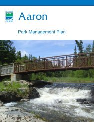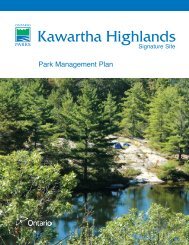
Kawartha Highlands - Ontario Parks
Kawartha Highlands - Ontario Parks
Kawartha Highlands - Ontario Parks

You also want an ePaper? Increase the reach of your titles
YUMPU automatically turns print PDFs into web optimized ePapers that Google loves.
The site provides excellent representation of<br />
the wide range of rock types and units present in<br />
the Harvey-Cardiff Arch Domain, one of the three<br />
subdivisions of the Elzevir Terrane. Because of the<br />
superb exposure and pristine condition of the area,<br />
this representation is considered to be provincially<br />
significant. Representation is made of elements of<br />
the Grenville Province basement rocks, and rocks of<br />
the Grenville Supergroup, within the environmental<br />
theme known as: Helikian Grenvillian Island Arcs,<br />
Sedimentary Basins and Continental Drift<br />
Environment (Davidson, 1981).<br />
Representation of elements of the surficial<br />
geology in the <strong>Kawartha</strong> <strong>Highlands</strong> Signature Site<br />
is locally significant. Bedrock-drift complexes are<br />
common to the region, and are well represented<br />
in other protected areas.<br />
4.5.2 Soils (refer to Figure 6)<br />
The soils of the <strong>Kawartha</strong> <strong>Highlands</strong> area are<br />
composed primarily of materials left behind by<br />
glaciers, with ice-scoured, bare rocklands<br />
predominate in much of the area. It is likely that<br />
intensive logging during the late nineteenth and<br />
early twentieth centuries has caused significant<br />
soil erosion. Also, extensive wildfires swept<br />
through the area in the early part of the twentieth<br />
century, burning away much of the shallow organic<br />
soils occurring on bedrock outcrops. As a result,<br />
both soil quality and quantity have been reduced –<br />
very recently on the geological calendar.<br />
According to the Soil Survey of Peterborough<br />
County mapping, most of the north-eastern,<br />
south-eastern and south-western portions of the<br />
<strong>Kawartha</strong> <strong>Highlands</strong> are rocklands (or rock<br />
outcrops), which may have pockets of shallow<br />
sandy till or organic deposits, but are primarily<br />
exposed bedrock and excessively drained. A zone<br />
of excessively- to well-drained Monteagle sandy<br />
loam extends from the east-central portion of the<br />
study area near Apsley to the eastern shores of<br />
Mississagua Lake, and through much of the<br />
north-central portion of the <strong>Kawartha</strong> <strong>Highlands</strong><br />
to the north-western limit. Another area of<br />
Monteagle sandy loam occurs in the south-central<br />
portion of the area, between Crane and Cherry<br />
lakes, extending south onto the limestone plain<br />
north of Highway 36. The vast majority of the<br />
study area is composed of combinations of<br />
rockland and Monteagle sandy loam soil types<br />
(Gillespie and Acton, 1981).<br />
Minor areas of Wendigo sandy loams occur<br />
north of Pencil Lake, north of Bottle Lake and<br />
along the south shore of Anstruther Lake, and in<br />
narrow strips from the east end of Long Lake<br />
south to Big Cedar Lake, and along the northern<br />
portion of Mississagua River. Pockets of Tweed<br />
sandy loam, derived from marble bedrock, are<br />
found northeast of Pencil Lake and along the<br />
extreme north-eastern boundary of the area.<br />
Wemyss loamy sand soils, which are imperfectly<br />
drained, occur between Sucker Creek and<br />
Anstruther Lake. Farmington loams and Dummer<br />
sandy loams, both of them well drained, are<br />
associated with the limestone plain at the southern<br />
edge of the area (Gillespie and Acton, 1981).<br />
Organic mucks and peat deposits are found in<br />
the seasonal and permanent wetlands that occur<br />
throughout the <strong>Kawartha</strong> <strong>Highlands</strong>.<br />
4.5.3 Land Types (refer to Figure 6)<br />
The following description of Land Types is adapted<br />
from van der Meer (2000):<br />
The <strong>Ontario</strong> Land Inventory has defined<br />
three broad “Land Types” in or near the study<br />
area, reflecting the parent materials of the soil<br />
categories described above. The Henvey Land<br />
Type is predominantly exposed igneous or<br />
metamorphic bedrock, described as low base<br />
granite, granite 12 gneiss or syenite. It coincides<br />
with the extensive rockland and Monteagle<br />
sandy loam soil areas, occupying most of<br />
Anstruther, Burleigh and Harvey townships.<br />
The Sherborne Land Type, a very low base<br />
loamy sand to silty sand, usually with high stone<br />
content, is derived from granite, granite gneiss<br />
or syenite bedrock. It is generally ice laid<br />
(occasionally water laid) till in the form of<br />
ground moraine. These very shallow (