Preliminary Plan Cover_Feb 14_08.indd - Ontario Parks
Preliminary Plan Cover_Feb 14_08.indd - Ontario Parks
Preliminary Plan Cover_Feb 14_08.indd - Ontario Parks

Create successful ePaper yourself
Turn your PDF publications into a flip-book with our unique Google optimized e-Paper software.
Turtle River -<br />
White Otter Lake<br />
<strong>Preliminary</strong> Park Management <strong>Plan</strong> (revised)
© 2010, Queen’s Printer for <strong>Ontario</strong><br />
<strong>Cover</strong> photo by Scott Ellery<br />
Printed in <strong>Ontario</strong>, Canada<br />
Copies of this publication are available from the Ministry of Natural Resources at the following<br />
locations:<br />
Ignace Area Office<br />
Hwy 599<br />
P.O. Box 448<br />
Ignace, ON P0T 1T0<br />
Tel: (807) 934-2233<br />
Fax: (807) 934-2304<br />
Dryden District Office<br />
479 Government Road<br />
P.O. Box 730<br />
Dryden, ON P8N 2Z4<br />
Tel: (807) 223-3341<br />
Fax: (807) 223-2824<br />
Atikokan Area Office<br />
108 Saturn Ave.<br />
Atikokan, ON P0T 1C0<br />
Tel: (807) 597-6971<br />
Fax: (807) 597-6185<br />
Fort Frances District Office<br />
922 Scott Street<br />
Fort Frances, ON P9A 1J4<br />
Tel: (807) 274-5337<br />
Fax: (807) 274-4438<br />
<strong>Ontario</strong> <strong>Parks</strong><br />
Northwest Zone Office<br />
Suite 221d 435 James St. S.<br />
Thunder Bay, ON P7E 6S8<br />
Tel: (807) 475-1231<br />
Fax: (807) 475-<strong>14</strong>99<br />
<strong>Plan</strong>ning questions can be addressed to:<br />
Superintendent, Turtle River – White Otter Lake<br />
Provincial Park<br />
Dryden District Office<br />
479 Government Road<br />
P.O. Box 730<br />
Dryden, ON P8N 2Z4<br />
Tel: (807) 223-7535<br />
<strong>Ontario</strong> <strong>Parks</strong><br />
Northwest Zone Office<br />
Suite 221d 435 James St. S.<br />
Thunder Bay, ON P7E 6S8<br />
Tel: (807) 475-1231<br />
Cette publication hautement spécialisée Turtle River-White Otter Lake <strong>Preliminary</strong> Park Management<br />
<strong>Plan</strong> n’est disponible qu’en Anglais en vertu du Règlement 411/97 qui en exempte l’application de la Loi<br />
sur les services en français. Pour obtenir de l’aide en français, veuillez communiquer avec Robin Reilly<br />
au ministère des Richesses naturelles au 807.597.5018 ou robin.reilly@ontario.ca.<br />
52676<br />
0.0 k P.R. 01 11 10<br />
ISBN - 978-1-4435-4655-3<br />
Turtle River–White Otter Lake Provincial Park<br />
<strong>Preliminary</strong> Management <strong>Plan</strong> (revised) - 2010
Invitation to Comment<br />
<strong>Ontario</strong> <strong>Parks</strong> is presently engaged in the management planning process for Turtle River–White Otter<br />
Lake Provincial Park. As part of the planning process, the Turtle River–White Otter Lake <strong>Preliminary</strong> Park<br />
Management <strong>Plan</strong> is presented.<br />
The preliminary park management plan initially released in 1992 has been updated to reflect additional<br />
planning associated with Keep It Wild (1994) and Lands for Life (1997-99) planning processes, and<br />
<strong>Ontario</strong>’s Living Legacy – Land Use Strategy (1999). This revised preliminary park management plan<br />
contains the proposed policies and direction for the long-term protection, development and management<br />
of Turtle River–White Otter Lake Provincial Park. It presents the park’s classification, goal, objectives,<br />
zoning, and resource management, operations, development and implementation policies for a waterway<br />
class park as defined by <strong>Ontario</strong> Provincial <strong>Parks</strong>: <strong>Plan</strong>ning and Management Policies (1992). The public<br />
consultation that has occurred to-date is also summarized.<br />
I invite you to participate in the management planning process for Turtle River–White Otter Lake<br />
Provincial Park. You are invited to review and comment on the preliminary park management plan<br />
(revised). Remarks or requests for additional information should be submitted to the attention of:<br />
Scott Ellery, Turtle River–White Otter Lake Provincial Park Superintendent<br />
Ministry of Natural Resources<br />
479 Government Road<br />
P.O. Box 730<br />
Dryden, ON P8N 2Z4<br />
scott.ellery@ontario.ca.<br />
(807) 223-7535<br />
The MNR is collecting your personal information and comments under the authority of <strong>Ontario</strong>’s Provincial<br />
<strong>Parks</strong> and Conservation Reserves Act. Any personal information you provide (address, name, telephone,<br />
etc.) will be protected in accordance with the Freedom of Information and Protection of Privacy Act,<br />
however your comments will become part of the record of consultation and may be shared with the<br />
general public. Your personal information may be used by the MNR to send you information about future<br />
MNR planning initiatives in the park area. For further information regarding this Act, please contact<br />
Rachel Hill in Fort Frances District at 807-274-8605.<br />
Turtle River–White Otter Lake Provincial Park<br />
<strong>Preliminary</strong> Management <strong>Plan</strong> (revised) - 2010
Table of Contents<br />
CONTEXT....................................................................................................................................................................1<br />
PROVINCIAL PARKS AND CONSERVATION RESERVES ACT.....................................................................1<br />
PLANNING CONTEXT ..............................................................................................................................................1<br />
ABORIGINAL PEOPLES..........................................................................................................................................2<br />
1.0 INTRODUCTION.............................................................................................................................................3<br />
2.0 SUMMARY OF SIGNIFICANT ISSUES (NOT RANKED) ........................................................................5<br />
2.1 ACCESS...............................................................................................................................................................5<br />
2.2 RECREATIONAL USES AND DEVELOPMENT PERMITTED IN THE PARK ................................................................5<br />
2.3 BOAT CACHES.....................................................................................................................................................5<br />
3.0 CLASSIFICATION..........................................................................................................................................5<br />
4.0 GOAL................................................................................................................................................................6<br />
5.0 OBJECTIVES..................................................................................................................................................6<br />
5.1 PROTECTION .....................................................................................................................................................6<br />
5.1.1 Life Science..............................................................................................................................................7<br />
5.1.2 Earth Science...........................................................................................................................................7<br />
5.1.3 Cultural Features ....................................................................................................................................8<br />
5.2 RECREATION.....................................................................................................................................................8<br />
5.3 HERITAGE APPRECIATION ................................................................................................................................9<br />
5.4 SCIENTIFIC RESEARCH ...................................................................................................................................10<br />
6.0 BOUNDARY ..................................................................................................................................................10<br />
7.0 PARK ZONING .............................................................................................................................................10<br />
7.1 NATURE RESERVE ZONES..............................................................................................................................11<br />
7.1.1 Nature Reserve Zone Management Policies..................................................................................12<br />
7.2 HISTORICAL ZONES ........................................................................................................................................13<br />
7.2.1 Historical Zone Management Policies.............................................................................................13<br />
7.3 NATURAL ENVIRONMENT ZONES ...................................................................................................................13<br />
7.3.1 Natural Environment Zone Management Policies ..................................................................15<br />
7.4 ACCESS ZONES ..............................................................................................................................................15<br />
7.4.1 Access Zone Management Policies .................................................................................................16<br />
7.5 DEVELOPMENT ZONES ...................................................................................................................................16<br />
7.5.1 Development Zone Management Policies ................................................................................17<br />
8.0 RESOURCE STEWARDSHIP POLICIES ................................................................................................17<br />
8.1 ABORIGINAL USES OF NATURAL RESOURCES ..............................................................................................17<br />
8.2 LAND MANAGEMENT ......................................................................................................................................17<br />
8.3 COMMERCIAL TOURISM SERVICES.................................................................................................................18<br />
Turtle River–White Otter Lake Provincial Park<br />
<strong>Preliminary</strong> Management <strong>Plan</strong> (revised) - 2010
8.4 VEGETATION MANAGEMENT...........................................................................................................................18<br />
8.5 ADJACENT LAND MANAGEMENT....................................................................................................................19<br />
8.6 FOREST FIRE MANAGEMENT..........................................................................................................................19<br />
8.7 WATER MANAGEMENT ...................................................................................................................................20<br />
8.8 FISHERIES MANAGEMENT...............................................................................................................................20<br />
8.9 WILDLIFE MANAGEMENT ................................................................................................................................22<br />
8.10 CULTURAL HERITAGE MANAGEMENT ............................................................................................................24<br />
9.0 PARK OPERATIONS POLICIES...............................................................................................................24<br />
9.1 RECREATION MANAGEMENT ..........................................................................................................................25<br />
9.1.1 Day-Use Areas .......................................................................................................................................26<br />
9.1.2 Trails ........................................................................................................................................................26<br />
9.1.3 Canoe Routes and Portages ..............................................................................................................26<br />
9.1.4 Camping ..................................................................................................................................................26<br />
9.2 MECHANIZED TRAVEL.....................................................................................................................................26<br />
9.2.1 Motorboats ...........................................................................................................................................26<br />
9.2.2 Snowmobiles .......................................................................................................................................27<br />
9.2.3 Aircraft.....................................................................................................................................................27<br />
9.2.4 All Terrain Vehicles ............................................................................................................................27<br />
9.2.5 Social and Economic Links................................................................................................................28<br />
9.3 ACCESS TO THE PARK ....................................................................................................................................28<br />
9.3.1 Road Access........................................................................................................................................28<br />
9.3.2 Water Access.......................................................................................................................................29<br />
9.4 RIVER CROSSINGS..........................................................................................................................................29<br />
9.4.1 Bridges ..................................................................................................................................................29<br />
9.4.2 Utility Corridors...................................................................................................................................29<br />
9.5 BOAT CACHES ................................................................................................................................................29<br />
9.6 NATURAL HERITAGE EDUCATION ..................................................................................................................30<br />
9.6.1 Park Information .................................................................................................................................30<br />
9.6.2 Interpretation .......................................................................................................................................30<br />
9.6.3 Recreation...............................................................................................................................................31<br />
9.7 MARKETING.....................................................................................................................................................31<br />
9.8 RESEARCH ......................................................................................................................................................32<br />
10.0 DEVELOPMENT POLICIES.......................................................................................................................32<br />
10.1 HISTORICAL ZONE 1 .......................................................................................................................................32<br />
10.2 ACCESS AND DEVELOPMENT ZONES.............................................................................................................33<br />
10.3 PARK INTERIOR...............................................................................................................................................33<br />
10.4 PARK SIGNAGE...............................................................................................................................................33<br />
10.5 FRIENDS OF WHITE OTTER CASTLE ..............................................................................................................33<br />
11.0 IMPLEMENTATION PRIORITIES..........................................................................................................34<br />
11.1 RESOURCE STEWARDSHIP PRIORITIES..........................................................................................................34<br />
11.2 OPERATIONS/ADMINISTRATION ..............................................................................................................34<br />
11.3 DEVELOPMENT PRIORITIES ............................................................................................................................35<br />
11.4 PHASE OUT OF COMMERCIAL .................................................................................................................35<br />
11.5 PROJECT SCREENING .............................................................................................................................35<br />
12.0 SOCIAL AND ECONOMIC IMPACT ANALYSIS................................................................................35<br />
Turtle River–White Otter Lake Provincial Park<br />
<strong>Preliminary</strong> Management <strong>Plan</strong> (revised) - 2010
13.0 PLAN AMENDMENT AND REVIEW.....................................................................................................36<br />
<strong>14</strong>.0 SUMMARY OF PUBLIC AND ABORIGINAL CONSULTATION......................................................36<br />
<strong>14</strong>.1 TERMS OF REFERENCE...................................................................................................................................36<br />
<strong>14</strong>.2 BACKGROUND INFORMATION AND CONCEPT PLAN ......................................................................................36<br />
<strong>14</strong>.3 PRELIMINARY MANAGEMENT PLAN (1992)...................................................................................................37<br />
<strong>14</strong>.4 KEEP IT WILD..................................................................................................................................................37<br />
<strong>14</strong>.5 ONTARIO'S LIVING LEGACY............................................................................................................................37<br />
<strong>14</strong>.6 PRELIMINARY PLAN (REVISED) - 2010...........................................................................................................37<br />
APPENDIX A - SOCIAL AND ECONOMIC ANALYSIS NOTES AND DEFINITIONS..............................42<br />
List of Figures<br />
Figure 1 Regional Setting………………………………………………………………………………………..43<br />
Figure 2 Existing Development and Adjacent Land Use - Map 2A ………………………………………44<br />
Figure 2 Existing Development and Adjacent Land Use - Map 2B ………………………………………45<br />
Figure 3 Proposed Zoning - Map 3A …………………………………………………………………………..46<br />
Figure 3 Proposed Zoning - Map 3B …………………………………………………………………………..47<br />
Turtle River–White Otter Lake Provincial Park<br />
<strong>Preliminary</strong> Management <strong>Plan</strong> (revised) - 2010
1<br />
Context<br />
Provincial <strong>Parks</strong> and Conservation Reserves Act<br />
The Provincial <strong>Parks</strong> and Conservation Reserves Act (PPCRA) is the legislation that guides the planning<br />
and management of the protected areas system. The PPCRA has two specific principles that guide all<br />
aspects of planning and management of <strong>Ontario</strong>’s system of provincial parks and conservation reserves:<br />
• Maintenance of ecological integrity shall be the first priority and the restoration of ecological<br />
integrity shall be considered<br />
• Opportunities for consultation shall be provided. 2006, c. 12, s. 3<br />
Consideration of the Ministry of Natural Resources’ Statement of Environmental<br />
Values under the Environmental Bill of Rights<br />
The Ministry of Natural Resources’ Statement of Environmental Values (SEV) under the Environmental Bill<br />
of Rights (EBR) describes how the purposes of the EBR are to be considered whenever decisions are made<br />
in the Ministry that might significantly affect the environment. This includes decisions made as a result of<br />
preparing management direction for a protected area.<br />
The Ministry’s SEV has been considered throughout the planning process. The management direction for<br />
Turtle River–White Otter Provincial Park will further the objectives of managing <strong>Ontario</strong>’s resources on an<br />
environmentally sustainable basis.<br />
<strong>Plan</strong>ning Context<br />
This preliminary park management plan has been prepared consistent with direction contained in Our<br />
Sustainable Future, Ministry of Natural Resources Strategic Directions (2005). The Ministry’s vision is<br />
“sustainable development”; and the Ministry’s mission is “ecological sustainability”. The <strong>Ontario</strong> <strong>Parks</strong><br />
program contributes mainly to the goal of: “Healthy Natural Environment for Ontarians”, but contributes to<br />
other strategic elements as well. The mandate of the Ministry for <strong>Ontario</strong> <strong>Parks</strong> is to deliver <strong>Ontario</strong>’s<br />
parks and protected areas program, which includes: the protection and management of provincially<br />
significant natural, cultural, and recreational environments; provincial parks operations; provision of<br />
tourism opportunities, natural heritage education; planning and management of parks and protected<br />
areas; policy leadership on conservation reserves; monitoring, auditing, and public reporting on <strong>Ontario</strong>’s<br />
parks and protected areas.<br />
This document has also been prepared consistent with direction contained in Protecting What Sustains<br />
Us: <strong>Ontario</strong>’s Biodiversity Strategy (2005). <strong>Ontario</strong> <strong>Parks</strong> supports both the first goal “Protect the genetic,<br />
species and ecosystem diversity of <strong>Ontario</strong>”, and the second goal: “Use and develop the biological assets<br />
of <strong>Ontario</strong> sustainably, and capture benefits from such use for Ontarians”. In particular Turtle River–White<br />
Otter Lake Provincial Park will be managed to protect any species at risk and their habitats in a manner<br />
consistent with the Endangered Species Act and regulations.<br />
Turtle River–White Otter Lake Provincial Park<br />
<strong>Preliminary</strong> Management <strong>Plan</strong> (revised) - 2010
2<br />
Aboriginal Peoples<br />
Wabigoon Lake, Lac La Croix, Seine River, Lac des Milles Lacs, Nigigoonsiminikaaning and Couchiching<br />
are nearby First Nations and are all within the boundary described by the Treaty #3 (Figure 1). Turtle<br />
River–White Otter Lake Provincial Park is part of the traditional use area of these Aboriginal communities.<br />
There are no land claims regarding Turtle River-White Otter Lake Provincial Park at this time.<br />
Turtle River–White Otter Lake Provincial Park overlaps traditional lands and waters of these five<br />
Aboriginal communities. Aboriginal communities use the area for hunting, trapping, fishing, gathering and<br />
travel.<br />
In recognition of the Aboriginal archaeological features located within the park, <strong>Ontario</strong> <strong>Parks</strong> will have<br />
special regard for local First Nations’ particular interests. Respect and protection of archaeological and<br />
cultural features are integral to this park management plan. The First Nations will be consulted on related<br />
issues of concern during the implementation of this plan.<br />
Turtle River–White Otter Lake Provincial Park<br />
<strong>Preliminary</strong> Management <strong>Plan</strong> (revised) - 2010
3<br />
1.0 INTRODUCTION<br />
Turtle River Provincial Park was formally<br />
established as a waterway class park in May<br />
1989. The park originally extended for about 160<br />
kilometres along the Balmoral and Turtle Rivers<br />
and associated lakes, and totalled 40,052<br />
hectares.<br />
<strong>Plan</strong>ning for Turtle River Provincial Park was<br />
initiated in 1989, with the approval of Terms of<br />
Reference. In <strong>Feb</strong>ruary 1990, Turtle River<br />
Provincial Waterway Park: Background<br />
Information and Turtle River Provincial<br />
Waterway Park: Concept <strong>Plan</strong> were distributed<br />
to a park mailing list with an eight page<br />
questionnaire. Information centres were held in<br />
Atikokan, Dryden, Fort Frances, Ignace, and<br />
Thunder Bay in March 1990. MNR staff held<br />
meetings with organizations and with residents<br />
of smaller communities in <strong>Feb</strong>ruary and March<br />
1990. The Turtle River–White Otter Lake<br />
Provincial Park: <strong>Preliminary</strong> Management <strong>Plan</strong><br />
was distributed to an expanded park mailing list<br />
in January 1992.<br />
Approval of the final plan was deferred in 1994<br />
when MNR undertook a program called Keep it<br />
Wild to establish additional natural heritage<br />
areas worthy of protection as provincial parks.<br />
As a result, 1,086 hectares of old growth red and<br />
white pine forest on the Lost Bay Peninsula of<br />
White Otter Lake was recommended for addition<br />
to the park as a nature reserve zone<br />
In 1997, MNR announced a comprehensive land<br />
use planning program, Lands for Life; one of its<br />
objectives was to complete <strong>Ontario</strong>'s system of<br />
parks and protected areas in the planning area.<br />
As a result, many recommended new protected<br />
areas were proposed and reviewed as part of an<br />
<strong>Ontario</strong>-wide public consultation program.<br />
The result of Lands for Life was the approved<br />
<strong>Ontario</strong>'s Living Legacy - Land Use Strategy<br />
(LUS) released in July 1999. One of the<br />
Strategy's recommended park additions was<br />
Area P2304, Turtle River Provincial Park<br />
Addition. This area included:<br />
• The additions proposed in the 1992<br />
<strong>Preliminary</strong> Management <strong>Plan</strong>,<br />
• The Lost Bay Peninsula addition, proposed<br />
in 1994,<br />
• Various other additions intended to protect<br />
representative landform - vegetation types.<br />
The 1992 <strong>Preliminary</strong> <strong>Plan</strong> also proposed that<br />
several areas be deleted from the park. As a<br />
result of <strong>Ontario</strong>'s Living Legacy Land Use<br />
Strategy, all of these areas were retained in the<br />
park except for the Ann Bay Ice Contact Delta.<br />
The OLL recommended boundary was then<br />
refined, taking into account detailed ecological<br />
information and surveying considerations, as<br />
well as consultation with affected resource users<br />
and the general public. In 2003, the park was<br />
renamed Turtle River–White Otter Lake<br />
Provincial Park and the boundary was amended<br />
(Figure 1). It now totals 49,294 hectares and is<br />
a non-operating park. For a more detailed<br />
summary of park planning to date and additional<br />
information on Lands for Life/<strong>Ontario</strong>’s Living<br />
Legacy refer to section <strong>14</strong>.5.<br />
The Land Use Strategy also changed some of<br />
the policies governing resource and recreational<br />
uses and facility development as they will apply<br />
to the new parks and park additions<br />
recommended by the Strategy. These policy<br />
changes are reflected throughout this<br />
preliminary plan (revised). 1<br />
Turtle River–White Otter Lake Provincial Park<br />
makes a major contribution to the provincial<br />
parks system. The Turtle River waterway has<br />
long been recognized as a significant canoe<br />
route and natural area with unique biophysical,<br />
recreational, and cultural attributes.<br />
The Turtle River water route proceeds from<br />
McNamara Lake over a height of land, to the<br />
1<br />
Turtle River–White Otter Lake <strong>Preliminary</strong> Park<br />
Management <strong>Plan</strong> (revised) has been developed in<br />
accordance with the <strong>Ontario</strong> Provincial <strong>Parks</strong> <strong>Plan</strong>ning and<br />
Management Policies (1992), <strong>Ontario</strong>’s Living Legacy Land<br />
Use Strategy (1999). In accordance with this plan, MNR will<br />
amend affected area-specific land use policies and mapping<br />
found in the Crown Land Use Policy Atlas<br />
http://crownlanduseatlas.mnr.gov.on.ca/.<br />
Turtle River–White Otter Lake Provincial Park<br />
<strong>Preliminary</strong> Management <strong>Plan</strong> (revised) - 2010
4<br />
headwaters of the Balmoral River, and continues<br />
downstream to join the Turtle River-proper near<br />
White Otter Lake. There are numerous lakes,<br />
22 sets of rapids, and about 30 portages along<br />
the route. White Otter and Eltrut are the park's<br />
largest lakes, followed by McNamara, Dibble,<br />
Smirch, and Jones. The park is used<br />
extensively in summer for activities such as<br />
boating, canoeing, and angling, while<br />
snowmobiling and ice fishing are popular winter<br />
activities.<br />
The park's waters vary widely, from the clear<br />
cold lake trout habitat of White Otter Lake to the<br />
warm brownish waters of Jones and Eltrut lakes.<br />
The southern reaches of the waterway have<br />
large marshes and areas of wild rice, which<br />
provide abundant habitat for moose and<br />
waterfowl. Some of the park's vegetative and<br />
glacial features are considered to be of regional<br />
and provincial significance.<br />
The park is situated in a bedrock-controlled<br />
landscape typical of the Precambrian Shield,<br />
while the park's vegetation is representative of<br />
the transitional zone between the Great Lakes-<br />
St. Lawrence and Boreal forest regions. Boreal<br />
forest species such as white spruce, black<br />
spruce, balsam fir, jack pine, trembling aspen,<br />
and white birch are found interspersed with red<br />
and white pine and other species more typical of<br />
the Great Lakes-St. Lawrence forest.<br />
The waterway has been used for centuries as a<br />
travel and trade route within the Rainy River<br />
basin, and the abundance of pictographs (rock<br />
art) along the waterway attests to its Aboriginal<br />
importance. The most distinctive historical<br />
resource within the park is White Otter Castle,<br />
one of the best-known visitor attractions in the<br />
area. This enigmatic three-storey log structure<br />
was completed in the 1910s by Jimmy McQuat.<br />
Though not accessible by road, it is visited year<br />
round, via watercraft, aircraft and snowmobiles,<br />
by an estimated 5,000 to 7,000 persons<br />
annually.<br />
Another protected area recommended by<br />
<strong>Ontario</strong>’s Living Legacy is Campus Lake<br />
Conservation Reserve (C2299), which abuts<br />
Turtle River–White Otter Lake Provincial Park<br />
around the north ends of Ann and Sucker Bays<br />
of White Otter Lake. This 19,452 hectare<br />
conservation reserve contains representative<br />
landforms and vegetation types, including<br />
weakly broken beach, aeolian deposits and<br />
ground moraine. It also encompasses some<br />
spectacular scenic and recreational areas that<br />
complement Turtle River–White Otter Lake<br />
Provincial Park. The conservation reserve<br />
complements the park by protecting a diverse<br />
range of vegetation and landform features, as<br />
well as the recreational and tourism potential of<br />
several scenic lakes linked by canoe routes to<br />
White Otter Lake.<br />
White Otter Enhanced Management Area (EMA)<br />
(E24<strong>14</strong>) is another land use designation<br />
resulting from <strong>Ontario</strong>’s Living Legacy. This is a<br />
remote and relatively undeveloped area with<br />
excellent potential for further eco-tourism and<br />
backcountry recreation. The primary intent of<br />
the EMA is to carry out forest management<br />
activities in a manner that will facilitate future<br />
recreation and tourism potential and to avoid<br />
undesirable impacts on protected area values<br />
through careful planning of new road locations.<br />
Other provincial parks in the vicinity include<br />
Sandbar Lake, East English River, Bonheur<br />
River Kame, and Quetico. Tourist attractions in<br />
the area that link to the historical themes<br />
associated with Turtle River–White Otter Lake<br />
include: the mining museum in Atikokan,<br />
Manitou Mounds in Barwick, and Fort William<br />
Historical Park in Thunder Bay.<br />
Turtle River–White Otter Lake Provincial Park is<br />
located between the Town of Ignace on Highway<br />
17, the hamlet of Mine Center and the Town of<br />
Atikokan on Highway 11. Other communities in<br />
the area include Upsala, Dryden, Fort Frances,<br />
Kenora and Thunder Bay.<br />
The approved park management plan will guide<br />
the management, operation and development of<br />
Turtle River–White Otter Lake over the next 20<br />
years. The plan may be reviewed or amended<br />
as the need arises; Section 13 describes the<br />
process for review and amendment of the plan.<br />
Turtle River–White Otter Lake Provincial Park<br />
<strong>Preliminary</strong> Management <strong>Plan</strong> (revised) - 2010
5<br />
2.0 SUMMARY OF SIGNIFICANT<br />
ISSUES (not ranked)<br />
A number of significant issues have been<br />
identified through public consultation during<br />
earlier stages of park planning.<br />
2.1 Access<br />
There will be five formal access zones<br />
designated for the park (Section 7.4) and the<br />
general policies governing access locations and<br />
the creation of access roads have been clarified<br />
(see Section 9.3.1).<br />
In addition to the five formal access zones, there<br />
are seven existing remote access points. These<br />
remote access points will be permitted to<br />
continue to be used, but will not be maintained<br />
and will deteriorate naturally. These include<br />
Moosehide/Devil’s Gap, Dibble, Smirch,<br />
Kenorain Creek, Manion Lake Road, Robinson<br />
Lake, and Jones Lake. Access to the park other<br />
than from designated access zones is discussed<br />
in sections 9.3.1 and 9.3.2.<br />
2.2 Recreational uses and development<br />
permitted in the park<br />
Respondents were also in favour of<br />
campgrounds, roofed accommodations,<br />
mechanical portages, baitfish harvesting and<br />
unrestricted mechanized travel.<br />
The permitted uses in this plan are consistent<br />
with <strong>Ontario</strong> Provincial <strong>Parks</strong>: <strong>Plan</strong>ning and<br />
Management Policies as modified by <strong>Ontario</strong>'s<br />
Living Legacy Land Use Strategy. However, the<br />
following restrictions have been added to those<br />
proposed in the 1992 <strong>Preliminary</strong> <strong>Plan</strong>:<br />
• Snowmachine and all-terrain vehicle use is<br />
restricted to designated land-based trails in<br />
natural environment zones, and designated<br />
roads and trails in access and development<br />
zones.<br />
• Snowmachines are permitted to travel on<br />
lakes for ice fishing and on the ice of White<br />
Otter Lake to access the castle.<br />
• Snowmachine or all-terrain vehicle use is<br />
not permitted in historical and nature reserve<br />
zones.<br />
2.3 Boat caches<br />
Respondents to the 1990 Concept <strong>Plan</strong><br />
supported private and commercial boat caches.<br />
Generally Northwestern <strong>Ontario</strong> boat caches<br />
continue to be supported by the public and most<br />
user groups. There is a general sentiment that<br />
all users should be able to keep boat caches or<br />
none at all.<br />
Commercial tourist operations will continue to be<br />
permitted to keep boat caches. The<br />
continuation of the existing outpost camps has<br />
been recognized as desirable throughout the<br />
planning process and is consistent with <strong>Ontario</strong><br />
Provincial <strong>Parks</strong>: <strong>Plan</strong>ning and Management<br />
Policies. Boat caches are recognized by MNR<br />
policy as a legitimate and necessary part of the<br />
outpost camp business in Northwestern <strong>Ontario</strong>.<br />
Local resource harvesters will also continue to<br />
be allowed to keep boat caches.<br />
Private individuals will be allowed to maintain<br />
their existing boat caches for recreational use<br />
subject to resource management principles, as<br />
authorized by the Park Superintendent, and the<br />
following conditions:<br />
• boat caches will not be transferable;<br />
• a boat that is removed from the park cannot<br />
be returned;<br />
• relocation outside the park will be<br />
encouraged;<br />
• boats will be located in a specific location on<br />
each lake as authorized by the Park<br />
Superintendent;<br />
• a fee for private and commercial boat<br />
caches may be instituted as determined by<br />
<strong>Ontario</strong> <strong>Parks</strong>.<br />
3.0 CLASSIFICATION<br />
Through park classification, <strong>Ontario</strong>’s provincial<br />
parks are organized into broad categories, each<br />
of which has particular purposes and<br />
characteristics.<br />
Turtle River–White Otter Lake Provincial Park is<br />
classified as a waterway park. The class target<br />
for waterway parks is to “establish at least one<br />
representative waterway in each of <strong>Ontario</strong>’s 71<br />
site districts” (OMNR 1992b, p. 35). Turtle<br />
Turtle River–White Otter Lake Provincial Park<br />
<strong>Preliminary</strong> Management <strong>Plan</strong> (revised) - 2010
6<br />
River–White Otter Lake Provincial Park helps to<br />
fulfil the representation target for waterway class<br />
parks in Ecodistrict 4S-5.<br />
Waterway class parks protect recreational water<br />
routes and representative and significant<br />
terrestrial and aquatic ecosystems and<br />
associated natural and cultural features and to<br />
provide high quality recreational and educational<br />
experiences.<br />
The waterway classification recognizes the park's<br />
ability to protect a scenic waterway and<br />
representative samples of Precambrian Shield<br />
and southern boreal forest, as well as the<br />
significant rock art sites along the waterway. It<br />
acknowledges the recreational and educational<br />
opportunities offered, the park's scenic setting,<br />
and the popularity of White Otter Lake and Castle<br />
as popular visitor destinations.<br />
4.0 GOAL<br />
The goal of Turtle River–White Otter Lake<br />
Provincial Park is:<br />
To protect significant natural and cultural<br />
features of Turtle River–White Otter Lake<br />
Provincial Park and to provide a wide variety<br />
of compatible, heritage appreciation, outdoor<br />
recreation, and scientific research activities,<br />
in order to achieve the objectives of the<br />
provincial parks system.<br />
Turtle River–White Otter Lake Provincial Park is<br />
governed by <strong>Ontario</strong>’s Provincial <strong>Parks</strong> and<br />
Conservation Reserves Act, <strong>Ontario</strong> Provincial<br />
<strong>Parks</strong>: <strong>Plan</strong>ning and Management Policies<br />
(1992) and <strong>Ontario</strong>’s Living Legacy - Land Use<br />
Strategy (1999).<br />
5.0 OBJECTIVES<br />
There are four objectives for the <strong>Ontario</strong><br />
provincial parks system: protection, recreation,<br />
heritage appreciation and scientific research.<br />
Each park in the system may contribute in some<br />
way to each of these objectives, depending on<br />
its resource base. Turtle River–White Otter<br />
Lake Provincial Park contributes to the<br />
achievement of all four objectives.<br />
5.1 Protection<br />
To permanently protect representative<br />
ecosystems, biodiversity and provincially<br />
significant elements of the natural and<br />
cultural landscape of Turtle River–White<br />
Otter Lake Provincial Park and to manage<br />
these to ensure that ecological integrity is<br />
maintained.<br />
<strong>Ontario</strong>’s protected areas play an important role<br />
in representing and conserving the diversity of<br />
<strong>Ontario</strong>’s natural features and ecosystems,<br />
across the broader landscape. Protected areas<br />
include representative examples of life and earth<br />
science features, and cultural heritage features<br />
within ecologically or geologically defined<br />
regions. <strong>Ontario</strong>’s ecological classification<br />
system provides the basis for the life science<br />
feature assessment, and the geological themes<br />
provide the basis for earth science assessment.<br />
The park contains natural and cultural resources<br />
that are provincially and regionally significant.<br />
These include:<br />
• A number of ice contact deltas including<br />
McNamara Lake (regional), White Otter<br />
Castle (regional), and Lost Bay (provincial);<br />
• An undisturbed section of the Eagle-<br />
Finlayson moraine (regional);<br />
• A remnant of glacial Lake Agassiz shoreline<br />
(regional);<br />
• Peatlands and transitional wetlands with<br />
plant species at the northern limits of their<br />
ranges (regional, possibly provincial);<br />
• Old growth red pine and white pine forest<br />
(local);<br />
• The prime lake trout fishery of White Otter<br />
Lake (local);<br />
• White Otter Castle (regional);<br />
• 37 known pictograph sites and 39 known<br />
prehistoric habitation sites as well as the<br />
remains of logging and prisoner of war<br />
camps (regional).<br />
The protection objective will be accomplished<br />
Turtle River–White Otter Lake Provincial Park<br />
<strong>Preliminary</strong> Management <strong>Plan</strong> (revised) - 2010
7<br />
through appropriate park zoning, resource<br />
management policies, research, and monitoring.<br />
5.1.1 Life Science<br />
Turtle River–White Otter Lake Provincial Park is<br />
situated in Ecodistricts 4S-5 and 3W-2. Due to<br />
the linear extent of the park, a vegetational<br />
gradient ranging from southern pine species of<br />
the Great Lakes-St. Lawrence Forest to the<br />
spruce/fir/birch species of the Boreal Forest is<br />
protected.<br />
The Quetico section of the Great Lakes-St.<br />
Lawrence Forest contains both red and white<br />
pine as individuals or in small stands. Several<br />
boreal forest-type species are also prevalent in<br />
this area with jack pine, trembling aspen, white<br />
birch, balsam fir, white spruce, and black spruce<br />
commonly observed. In wet valley sites<br />
hardwood species such as black ash, elm, and<br />
red maple are common. Along lake shores<br />
eastern white cedar is often prevalent. Black<br />
spruce and eastern tamarack are most often<br />
encountered in bogs and poor fens.<br />
In the Upper English River section of the Boreal<br />
Forest, the main forest cover is black spruce and<br />
jack pine. Jack pine is prevalent on dry sand<br />
flats and rocky uplands with black spruce the<br />
more common species in the moist, peat-filled<br />
sections of forest. In moderately dry habitats,<br />
mixed stands are common with jack pine and<br />
black spruce sharing the canopy with white<br />
spruce, balsam fir, trembling aspen, and white<br />
birch. Red and white pine also occur but reach<br />
their northern limits here and are usually only<br />
found as individuals, or in isolated clumps.<br />
Other species reaching the northern limits of<br />
their distribution in this section are the largetoothed<br />
aspen, yellow birch, and eastern white<br />
cedar. On drier sites several species not<br />
characteristic of the boreal forest, such as bur<br />
oak and white elm, can be observed (Hills<br />
1959).<br />
Adding to the park’s complexity is the presence<br />
of a southern deciduous/prairie transitional<br />
element such as birch, oak, green ash, silver<br />
maple on alluvial sites at the southern end of the<br />
park.<br />
Soils range from deep mineral to deep organic<br />
and shallow dry-very fresh to shallow moist<br />
soils.<br />
The faunal species found in the park are typical<br />
of the boreal forest, although a few species<br />
representative of the Great Lakes-St. Lawrence<br />
forest do occur, given the park’s location in a<br />
transitional forest region. Common mammals<br />
found within the park include moose, white-tailed<br />
deer, black bear, wolf, river otter, muskrat,<br />
beaver, mink, marten, fisher, fox, lynx, eastern<br />
chipmunk and red squirrel. Common bird<br />
species observed were least flycatcher, redeyed<br />
vireo, winter wren, white-throated sparrow,<br />
yellow-rumped warbler, and Swainson’s thrush.<br />
Provincially rare 2 species include bald eagle,<br />
caspian tern, winter bentgrass, fir-clubmoss,<br />
water dock, and dwarf birch.<br />
Turtle River–White Otter Lake Provincial Park<br />
has a number of life science features that are of<br />
interpretive and educational significance. Life<br />
science values are protected within nature<br />
reserve and natural environment zones.<br />
5.1.2 Earth Science<br />
Turtle River–White Otter Lake Provincial Park<br />
provides an ideal cross-section of granitic and<br />
gneissic rocks of the central portion of the<br />
Wabigoon Subprovince, including the White<br />
Otter batholith, a major Late Archean granitic<br />
intrusion. Although the influence of bedrock is<br />
readily seen in the drainage pattern of the park<br />
(e.g. rivers and lakes) it is the surficial material,<br />
or in some places lack of it, which often give an<br />
area its particular “look”. The surficial geology of<br />
the park includes glaciofluvial outwash plain,<br />
kame and esker complexes. The presence of<br />
the rarely seen red clays interbedded with grey<br />
2<br />
The Natural Heritage Information Centre (NHIC) compiles,<br />
maintains and provides information on rare, threatened and<br />
endangered species and spaces in <strong>Ontario</strong>. The NHIC<br />
assigns subnational ranks (S ranks) for species and plant<br />
communities. These range from S1 (extremely rare,<br />
generally 5 or fewer locations) to S5 (demonstrably secure).<br />
Turtle River–White Otter Lake Provincial Park<br />
<strong>Preliminary</strong> Management <strong>Plan</strong> (revised) - 2010
8<br />
clays are also of significance as they represent<br />
the expansion and contraction of glacial lake<br />
Agassiz in conjunction with the constantly<br />
changing ice front. A number of these earth<br />
science features are regionally and/or<br />
provincially significant and are of interpretive<br />
and educational significance.<br />
Earth science values are protected within nature<br />
reserve and natural environment zones.<br />
5.1.3 Cultural Features<br />
Turtle River–White Otter Lake Provincial Park<br />
has over 30 archaeological sites, 37 pictograph<br />
sites (Rusak 1992) and numerous logging<br />
remnants dating back to the early 20 th century<br />
have been documented.<br />
As the glaciers retreated, Aboriginal people<br />
moved into the area in small nomadic groups to<br />
gather, hunt and fish, occupying different<br />
seasonal habitation sites. The discovery of<br />
pictographs and lithic flakes and pottery shards<br />
from the Laurel and Blackduck cultures<br />
document this use. Tobacco offerings,<br />
frequently observed at some of the pictograph<br />
sites, suggest that these areas remain<br />
significant to the contemporary First Nations<br />
people.<br />
The Turtle River waterway was likely used for<br />
collecting and transporting furs after the Hudson<br />
Bay Company’s expansion inland. Logging<br />
began in the area around the turn of the century.<br />
Relics of this activity are found at several places<br />
in the park including the remains of three logging<br />
camps on White Otter Lake and an old<br />
amphibious “alligator” boat on the south shore of<br />
Eltrut Lake. The logging camp closest to the<br />
castle on White Otter Lake was used as a<br />
prisoner-of-war camp for German sailors from<br />
1943 to 1946.<br />
The most popular attraction in the park is the<br />
castle on White Otter Lake. Jimmy M c Quat, a<br />
hermit of Scottish origins, settled on White Otter<br />
Lake in 1903 and built a unique 3-storey<br />
structure without the help of anyone. He<br />
completed the castle in 19<strong>14</strong> at the age of 59.<br />
The castle is constructed of massive red pine<br />
logs, some of which are 30 to 40 metres in<br />
length and 50 centimetres in diameter, weighing<br />
up to one ton each. While living on White Otter<br />
Lake, M c Quat worked as trapper and<br />
commercial fisher until he drowned in front of the<br />
castle in 1918 while netting fish. M c Quat’s grave<br />
can still be seen today beside the recently<br />
restored White Otter Castle.<br />
The park has a number of cultural features that<br />
are of interpretive and educational significance.<br />
Cultural features are protected within historic<br />
and natural environment zones.<br />
Respect and protection of archaeological and<br />
cultural features are integral to the management<br />
of this park plan. The Lac des Milles Lac,<br />
Wabigoon Lake, Lac La Croix, Seine River,<br />
Rainy Lake, Nicickousemenecaning and<br />
Couchiching First Nations, whose traditional<br />
land use areas the park lies within, will be<br />
consulted on related issues of concern during<br />
implementation of the plan.<br />
5.2 Recreation<br />
To provide ecologically sustainable high<br />
quality river recreation travel and<br />
backcountry camping opportunities in an<br />
outstanding natural setting and to encourage<br />
associated economic benefits.<br />
Recreational opportunities in the park range<br />
from moderate intensity day-use to low intensity<br />
backcountry experiences. Park management<br />
will accommodate and support quality<br />
recreational angling (summer and winter),<br />
hunting, canoeing, scenic and wildlife viewing,<br />
camping, motor boating, and snowmobiling,<br />
including the provision of appropriate services<br />
and facilities.<br />
The recreation objective will be achieved<br />
through appropriate park zoning; the<br />
identification of management policies to prevent<br />
any compromise of significant natural and/or<br />
cultural heritage values; market research and<br />
monitoring; and, mitigating impacts of<br />
recreational use.<br />
Turtle River–White Otter Lake Provincial Park<br />
<strong>Preliminary</strong> Management <strong>Plan</strong> (revised) - 2010
9<br />
As a non-operating park, statistical data on the<br />
patterns of recreational use of Turtle River–<br />
White Otter Lake has not been formally<br />
compiled to date. Use of the park has increased<br />
dramatically in recent years and the park is<br />
becoming a popular destination among local and<br />
regional residents, as well as with non-residents<br />
and organized youth groups. White Otter Castle<br />
is a popular destination for year-round visitation,<br />
and contributes to the local economies of<br />
Atikokan and Ignace.<br />
Visitors to the operating provincial parks in the<br />
northwestern <strong>Ontario</strong> travel region originate in<br />
northwestern <strong>Ontario</strong> and in western Canada<br />
(approximately 40%), with substantial visitation<br />
from the American Midwest (about 40%),<br />
specifically Minnesota and Wisconsin. This is in<br />
contrast to the origins of park users on a<br />
province-wide basis where the majority of park<br />
visitors originate in the eastern and central parts<br />
of the province (approximately 65%) and only<br />
about 9% of visitors come from the United<br />
States.<br />
Tourism industry trends such as an aging<br />
population, increasing concern for the<br />
environment, and interest in educational<br />
experiences, indicate market growth potential for<br />
soft adventure and ecotourism. Examples of<br />
products include experiences in natural<br />
environments/cultural heritage with packaging of<br />
wildlife/scenic viewing, water- and land-based<br />
recreation. Trend analyses of visitors from<br />
overseas (Europe and Asia) indicates strong<br />
interest in the outdoors, natural and cultural<br />
heritage, especially that of First Nations. Turtle<br />
River–White Otter Lake Provincial Park and the<br />
surrounding locale are well positioned as part of<br />
an international attraction where there is<br />
opportunity for growth with independent tourists,<br />
and package tours (Van Wagoner 2000).<br />
Tourism use will be encouraged to the greatest<br />
extent possible without adversely affecting the<br />
park environment or visitor experiences.<br />
Tourism opportunities exist for hunting, fishing,<br />
canoe trip outfitting and tours to White Otter<br />
Castle.<br />
5.3 Heritage Appreciation<br />
To provide opportunities for residents of<br />
<strong>Ontario</strong> and visitors to increase their<br />
knowledge and appreciation and to<br />
participate in unstructured individual<br />
exploration of the natural and cultural<br />
heritage of Turtle River–White Otter Lake<br />
Provincial Park.<br />
There are three levels of Natural Heritage<br />
Education (NHE) service in the provincial park’s<br />
system: Self-use, Seasonal Activity, and Major<br />
Activity. Turtle River–White Otter Provincial Park<br />
currently offers a “self-use activity” level of NHE<br />
programming. Interpretive themes for the park<br />
may include:<br />
• White Otter Castle and the story of Jimmy<br />
M c Quat;<br />
• Early logging activities and their associated<br />
artefacts;<br />
• The German P.O.W. camp;<br />
• The prehistoric and historic indigenous<br />
cultures and contemporary First Nations<br />
with emphasis on rock art;<br />
• Geomorphological features including ice<br />
contact deltas such as McNamara Lake,<br />
White Otter Castle, and Lost Bay; an<br />
undisturbed section of the Eagle-Finlayson<br />
moraine, and a remnant of glacial Lake<br />
Agassiz shoreline;<br />
• The transitional forest and its relationship to<br />
major biological themes of the park and;<br />
• Park wildlife viewing opportunities.<br />
Opportunities will be provided for unstructured<br />
individual exploration and appreciation of the<br />
natural and cultural heritage of this important<br />
waterway. White Otter Castle will be a focal<br />
point of cultural heritage appreciation within the<br />
park; however the park also contains numerous<br />
pictograph sites and examples of industrial<br />
heritage related to the logging era. Significant<br />
earth science and life science features abound.<br />
This objective will be achieved through the<br />
provision of accurate up-to-date information to<br />
park visitors regarding the natural, cultural and<br />
recreational resources of the park through<br />
signage, park literature, trail guides and<br />
Turtle River–White Otter Lake Provincial Park<br />
<strong>Preliminary</strong> Management <strong>Plan</strong> (revised) - 2010
10<br />
interpretive displays as required. Natural<br />
heritage education is further discussed in<br />
Section 9.6.<br />
5.4 Scientific Research<br />
To facilitate scientific research and to<br />
provide points of reference to support<br />
monitoring of ecological change on the<br />
broader landscape.<br />
<strong>Ontario</strong>’s provincial parks play an important role<br />
in the provision of places to undertake research<br />
activities to: provide a better understanding of<br />
park environments, contribute to appropriate<br />
park management practices and actions, and<br />
provide baseline ecological information that can<br />
be used to support ecological monitoring on the<br />
broader landscape.<br />
6.0 BOUNDARY<br />
The park was originally established in 1989 as<br />
Turtle River Provincial Park.<br />
Several boundary changes have been made as<br />
a result of different land use planning initiatives<br />
designed to protect natural heritage. The 1992<br />
preliminary park management plan proposed<br />
adding four sites to the park and deleting five.<br />
The 1994 Keep It Wild program recommended<br />
adding one site to the park. <strong>Ontario</strong>’s Living<br />
Legacy recommended adding six sites to the<br />
park (including the four proposed in the initial<br />
preliminary park management plan) and deleting<br />
one site. These three planning processes<br />
included public consultation as part of the<br />
decision-making process. Boundary refinement,<br />
which included more consultation with<br />
stakeholders and the public, and notification of<br />
First Nations, has resulted in a variety of minor<br />
changes between the park additions as shown in<br />
the Land Use Strategy and those shown on<br />
Figure 1, Regional Setting, without changing the<br />
total net area of the additions.<br />
The boundary changes (park additions) are:<br />
• McNamara Lake Ice Contact Delta (238 ha)<br />
(Part 1 on reg. plan),<br />
• Site 2 (421 ha) (South of Elbow Lake) (Part<br />
2 on reg. plan),<br />
• Site 3 (481 ha) (Nora Lake) (Part 6 on reg.<br />
plan),<br />
• White Otter Castle Ice Contact Delta (225<br />
ha) (Part 9 on reg. plan),<br />
• Site 6 (3559 ha) (Rollingstone Lake) (Part<br />
13 on reg. plan),<br />
• Site 7 (2068 ha) (Dimple Lake) (Part 4 on<br />
reg. plan),<br />
• Site 8 (922 ha) (north of Heuston Lake)<br />
(Part 7 on reg. plan),<br />
• Site 9 (2045 ha) (Kenoshay Lake) (Part 5<br />
on reg. plan),<br />
• Site 10 (232 ha) (Paddy Lake) (Part 3 on<br />
reg. plan),<br />
• Treed Bog Rocklands (<strong>14</strong>6 ha) (Part 8 on<br />
reg. plan),<br />
• Lake Agassiz Shoreline (468 ha) (Part 11 on<br />
reg. plan),<br />
• Jones/Eltrut Riparian Wetlands (221 ha)<br />
(Part 12 on reg. plan),<br />
• Turtle River Terminus (121 ha) (Part <strong>14</strong> on<br />
reg. plan),<br />
• Ann Bay Ice Contact Delta (235 ha) has<br />
been removed from the park.<br />
Park management plan policies apply only to the<br />
area within the regulated boundary of the park.<br />
Within the park boundary, the protection of park<br />
values and features will be achieved through<br />
appropriate zoning, control of land use and<br />
activities, education, and monitoring of<br />
ecological impacts.<br />
The boundary of Turtle River–White Otter Lake<br />
Provincial Park is shown on the Zoning and<br />
Existing Development and Adjacent Land Use<br />
maps. All lands within 200 metres of the<br />
waterway shoreline and lands under water are<br />
included in the park, and in many areas, the<br />
boundary extends farther inland.<br />
7.0 PARK ZONING<br />
The types of zones that will guide the resource<br />
management, operations and development of<br />
Turtle River–White Otter Lake Provincial Park<br />
Turtle River–White Otter Lake Provincial Park<br />
<strong>Preliminary</strong> Management <strong>Plan</strong> (revised) - 2010
11<br />
are nature reserve, historical, natural<br />
environment, access and development<br />
(Proposed Zoning (Maps 3A and 3B)). No<br />
wilderness zones are proposed.<br />
Zoning is a key part of a park management plan.<br />
Zones fulfill a variety of functions that may<br />
include:<br />
• Recognizing the features and attributes of a<br />
park;<br />
• Delineating areas on the basis of their need<br />
for protection or their ability to protect<br />
provincially significant representative<br />
features;<br />
• Delineating areas on the basis of their ability<br />
to support various recreational activities;<br />
and,<br />
• Identifying uses that will protect significant<br />
features, yet allow opportunities for<br />
recreation and heritage appreciation.<br />
Management of the park’s resources is<br />
consistent with policies in <strong>Ontario</strong> Provincial<br />
<strong>Parks</strong> <strong>Plan</strong>ning and Management Policies<br />
(1992) and <strong>Ontario</strong>’s Living Legacy - Land Use<br />
Strategy (1999).<br />
The park additions identified in OLL have been<br />
zoned based upon the preliminary park<br />
management plan (1992), input during land use<br />
planning processes, and the known significance<br />
of values based on gap analysis. They are<br />
referred to below with the addition of (a) to the<br />
zone type and number.<br />
7.1 Nature Reserve Zones<br />
Nature reserve zones protect the provincially<br />
significant earth and/or life science features<br />
within a park. Development is generally<br />
restricted to trails, necessary signs, interpretive<br />
facilities (where warranted) and temporary<br />
facilities for research and management. The<br />
waters within the proposed nature reserve zones<br />
in Turtle River–White Otter Provincial Park are<br />
small ponds and streams that do not form part of<br />
the park’s canoe routes.<br />
NR1 / NR1(a) - McNamara Lake Ice Contact<br />
Deltas (518 hectares) Zoning Map 3A<br />
This zone protects two good examples of ice<br />
contact deltas deposited in an ice margin lake<br />
between the Eagle-Finlayson Moraine to the<br />
south and the Hartmann Moraine to the north.<br />
These are regionally significant as the best ice<br />
contact delta example anywhere near the park.<br />
This area was first proposed as a park addition<br />
and nature reserve zone in the 1992 preliminary<br />
park management plan. This zone is bisected<br />
by Zone A2 (McNamara Lake Winter Trail).<br />
NR2 / NR2(a) - White Otter Castle Ice Contact<br />
Delta (285 hectares) Zoning Map 3A<br />
This zone protects an excellent example of a<br />
"perched" or "hanging" delta formed in an ice<br />
margin lake, when the ice front retreated a few<br />
kilometres north of the Eagle-Finlayson Moraine.<br />
This area was first proposed as a park addition<br />
and nature reserve zone in the 1992 preliminary<br />
park management plan.<br />
NR3(a) - Rollingstone Lake Ice Contact<br />
Landforms (570 hectares) Zoning Map 3A<br />
South and east of Rollingstone Lake, this zone<br />
protects a variety of ice contact landforms such<br />
as kame knolls, extensive esker systems,<br />
boulder ridges, ice contact deltas, and kettle<br />
terrain. This is likely the best example of such a<br />
complex of features west of Thunder Bay and<br />
south of Highway 17, and is considered<br />
regionally and perhaps provincially, significant.<br />
This area was first proposed as a park addition<br />
and nature reserve zone in the 1992 preliminary<br />
park management plan.<br />
NR4(a) - Turtle River Treed Bog Rocklands<br />
(<strong>14</strong>6 hectares) Zoning Map 3A<br />
This zone protects large peatland basins<br />
consisting of treed and other types of bogs,<br />
surrounded by wave-washed bedrock with<br />
scattered clumps of jack pine. This locally<br />
significant site is a good representation of<br />
peatland and bedrock patterns found in the park.<br />
This area was first proposed as a park addition<br />
Turtle River–White Otter Lake Provincial Park<br />
<strong>Preliminary</strong> Management <strong>Plan</strong> (revised) - 2010
12<br />
in <strong>Ontario</strong>’s Living Legacy - Land Use Strategy<br />
(OLL-LUS) as a result of representation gap<br />
analysis.<br />
NR5 - Eagle-Finlayson Moraine (550<br />
hectares) Zoning Map 3B<br />
This zone protects excellent representation of a<br />
relatively undisturbed section of the Eagle-<br />
Finlayson moraine, a single ridge moraine<br />
deposited when the levels of glacial Lake<br />
Agassiz were high, about 11,000 years ago.<br />
The intolerant upland forest on the moraine's<br />
southwest ridge has educational and interpretive<br />
value, as it vividly portrays the relationship<br />
between vegetation and physiographic site<br />
characteristics. The Esker Lake forest<br />
management access road passes through the<br />
northeast corner of this zone This road has<br />
minimal effect on the earth science feature.<br />
The zone is bisected by NE4.<br />
NR6(a) - Lake Agassiz Shoreline (169<br />
hectares) Zoning Map 3B<br />
This zone protects clay substrates that indicate<br />
that this may have been a former eastern shore<br />
of postglacial Lake Agassiz, possibly the farthest<br />
that this lake extended up the Turtle River. This<br />
zone is delineated by the area with fewest<br />
human impacts, and the best examples of the<br />
glaciolacustrine deposits. Various upland and<br />
wetland plant communities are represented.<br />
This area (Parts 10 and 11) was first proposed<br />
through the OLL-LUS and recommended as a<br />
park addition; the nature reserve zone area was<br />
refined to capture the features described above<br />
and to exclude areas that were impacted by<br />
logging.<br />
NR7(a) - Turtle River Terminus (121 hectares)<br />
Zoning Map 3B<br />
This zone protects an extensive wetland<br />
dominated by characteristic marsh, swamp, and<br />
bog plant species. The site is significant<br />
because it is an area of transition between the<br />
Great Lakes-St. Lawrence and Boreal forests.<br />
Therefore, many plant species (for example,<br />
green ash, red oak, nannyberry, silver maple,<br />
bur oak, carrion flower, white elm, and<br />
hawthorn) are found here at the northern limits<br />
of their ranges. The alluvial swamp community,<br />
with its associated banks and levees, channel<br />
banks, backwater sloughs, incised meanders,<br />
and other features is considered to be<br />
regionally, possibly provincially, significant. This<br />
area was first proposed as a park addition and<br />
nature reserve zone in the 1992 preliminary park<br />
management plan. Water access to the park via<br />
Little Turtle Lake occurs here.<br />
NR8(a) – Lost Bay/Rollingstone Old Growth<br />
Red and White Pine (1085 hectares)<br />
Zoning Map 3A<br />
The zone protects old growth red and white pine<br />
forest north of Rollingstone Lake. This area was<br />
first proposed as a park addition and nature<br />
reserve zone in the 1994 Keep It Wild program.<br />
7.1.1 Nature Reserve Zone Management<br />
Policies<br />
The nature reserve zone designation recognizes<br />
the fragility of these resources. Only scientific,<br />
educational and interpretive use is permitted in<br />
this zone. Some minimum impact recreational<br />
activity such as hiking is acceptable provided<br />
there is no potential for features to be impacted.<br />
Development is limited to trails, directional and<br />
interpretive signs and temporary facilities for<br />
research and management.<br />
Hunting, backcountry camping, mechanized<br />
travel, rock climbing and scrambling are not<br />
permitted in nature reserve zones. Existing<br />
campsites in nature reserve zones will be<br />
closed.<br />
Trapping by aboriginal trappers can continue.<br />
Trapping by non-aboriginal people is not<br />
permitted in nature reserve zones in the original<br />
park. The Ministry is reviewing the phase out<br />
policy to determine what will happen to these<br />
traplines after 2009. The review included<br />
notification by mail to individuals affected by<br />
phase out inviting comment and those<br />
individuals will be notified of the decision. The<br />
2009 phase out date will not be implemented<br />
Turtle River–White Otter Lake Provincial Park<br />
<strong>Preliminary</strong> Management <strong>Plan</strong> (revised) - 2010
13<br />
until the review is complete and the policy<br />
decision will be applied to these traplines<br />
(Section 11.4). Trapping may continue in the<br />
OLL park additions.<br />
The existing forest management access road in<br />
the northeast corner of NR5 (Esker Lake Road)<br />
predates the establishment of the park and will<br />
be permitted to continue as a non-conforming<br />
use with existing levels of maintenance.<br />
7.2 Historical Zones<br />
Historical zones encompass the provincially<br />
significant cultural resources of a park. They<br />
generally focus on a specific site (e.g. area of<br />
human occupation site, building(s)) and that site’s<br />
relationship to the surrounding landscape, so they<br />
may include a protective buffer around the main<br />
feature in the zone. Development is limited to<br />
trails, necessary signs, and interpretive,<br />
educational, research and management facilities,<br />
such as historical restorations or reconstruction<br />
where appropriate.<br />
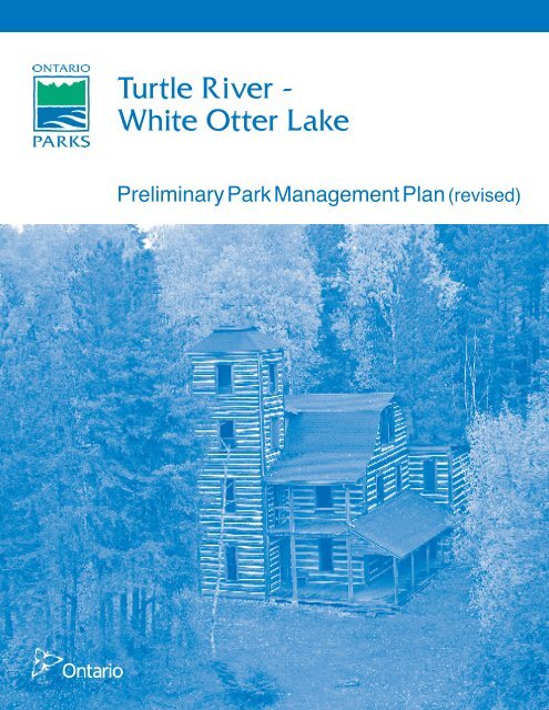
H1 - White Otter Castle (10 hectares)<br />
Zoning Map 3A<br />
The proposed White Otter Castle historical zone<br />
H1 does not include the waters of White Otter<br />
Lake. Zone H1 protects White Otter Castle,<br />
which is a key focus of the park and is popular<br />
with park visitors.<br />
White Otter Castle Feasibility Study (1989)<br />
investigated the options for the conservation and<br />
restoration of the Castle. The Castle was<br />
restored in 1994. The plan also proposed an<br />
interpretive trail and displays, a picnic area, and<br />
pit privies.<br />
The Friends of White Otter Castle Inc. is a nonprofit<br />
organization that works with <strong>Ontario</strong> <strong>Parks</strong><br />
to protect and promote the Castle. The Friends<br />
have been working with <strong>Ontario</strong> <strong>Parks</strong> to<br />
manage the 10-hectare Castle site including<br />
restoration, protection, and site management.<br />
H2 – Prisoner of War Camp (10 hectares)<br />
Zoning Map 3A<br />
North of the Castle, Zone H2 protects the<br />
remains of a 1930s logging camp, converted<br />
during the Second World War into a camp for<br />
German prisoners of war. This site is easily<br />
reached from the Castle, and is suitable for<br />
interpretive displays and self-guided trails.<br />
7.2.1 Historical Zone Management Policies<br />
Specific management strategies will be<br />
formulated for the H1 zone to ensure that<br />
operations are in keeping with the park's natural<br />
and cultural values. To this end, the Friends of<br />
White Otter Castle in consultation with <strong>Ontario</strong><br />
<strong>Parks</strong> will prepare an operating plan for Zone H1<br />
and a custodial management strategy for White<br />
Otter Castle.<br />
Day-use activities (e.g. fishing, canoeing, and<br />
viewing) are permitted in historical zones.<br />
Hunting, camping, and motorized vehicles are<br />
not permitted in historical zones although<br />
snowmobiles are permitted adjacent to the H1<br />
zone on White Otter Lake. Trapping may<br />
continue indefinitely in historical zones.<br />
Development is limited to trails, necessary signs,<br />
interpretive, educational, research and<br />
management facilities, and historical restoration<br />
or reconstruction where appropriate.<br />
7.3 Natural Environment Zones<br />
Natural environment zones include natural<br />
landscapes which permit the minimum level of<br />
development required to support low-intensity<br />
recreational activities. Development is generally<br />
limited to back-country campsites, portages,<br />
necessary signs and minimal interpretive<br />
facilities.<br />
There are 37 known pictograph sites (23 on<br />
White Otter Lake) and 39 known prehistoric<br />
occupation sites (where artefacts such as<br />
pottery shards, stone flakes, etc. were found) in<br />
the park. There are also many remains of dams,<br />
machinery, camps, etc. from logging and log<br />
driving earlier in the 20th century, including an<br />
alligator boat on Eltrut Lake. These artefacts will<br />
be protected within natural environment zones.<br />
Turtle River–White Otter Lake Provincial Park<br />
<strong>Preliminary</strong> Management <strong>Plan</strong> (revised) - 2010
<strong>14</strong><br />
The four proposed natural environment zones<br />
include the park's waters and river / lakebeds<br />
and account for 89% of the total park area.<br />
They incorporate relatively attractive and rugged<br />
sections of the park’s lands and river / lakebeds<br />
that offer high quality recreational opportunities,<br />
ranging from low intensity backcountry camping<br />
to higher intensity day-use.<br />
All of the Balmoral and Turtle Rivers’ water<br />
route, and all waterway portages except those in<br />
Zones A1, and A4 are included in the park's<br />
natural environment zones.<br />
NE1 / NE1(a)- Balmoral River (8,640 hectares)<br />
Zoning Map 3A<br />
This zone includes McNamara Lake, Part 2, Part<br />
3 and part of Site 4 (Figures 1 and 3) which<br />
were confirmed in the OLL-LUS as park<br />
additions in, as well as the area within 200<br />
metres of the water’s edge. The zone<br />
incorporates a shortcut bypassing White Otter<br />
Lake, and linking East Patricia, Dimple, Jac<br />
Saga and Dibble Lakes. Nora Lake offers<br />
exceptional camping opportunities, however the<br />
remainder of this zone has limited opportunities.<br />
Natural impediments to travel tend to preclude<br />
mechanized travel except for some mechanized<br />
travel associated with boat caches for outposts<br />
on Jac Saga, Nora and Dibble lakes.<br />
This zone will be managed primarily for its<br />
canoeing and backcountry camping<br />
opportunities, with little additional development.<br />
Existing development in the zone includes the<br />
snowmobile trail D1<strong>14</strong>A on McNamara Lake and<br />
many backcountry campsites.<br />
NE2 / NE2(a) - White Otter / Rollingstone and<br />
Hawknest Lakes (18,348 hectares)<br />
Zoning Map 3A<br />
This zone includes part of Parts 7, 9 and 13 that<br />
were confirmed in the OLL-LUS as park<br />
additions, as well as the area within 200 metres<br />
of the water’s edge. This zone's natural heritage<br />
features include:<br />
• The park's most extensive white pine<br />
stands, on Ann Bay,<br />
• White Otter Lake's oligotrophic character<br />
and prime lake trout fishery,<br />
• The best developed lacustrine deposits in<br />
the park. These include sand beaches,<br />
most notably on Ann Bay and near White<br />
Otter Castle, sandspits, and one small<br />
baymouth bar.<br />
White Otter Lake, and especially Ann Bay, offer<br />
exceptional backcountry camping opportunities.<br />
This zone will be managed to provide boat-in<br />
and canoe-in backcountry camping and public<br />
access to White Otter Castle, while protecting<br />
the environs of the lake. This zone contains<br />
snowmobile trail D115A, and a number of<br />
backcountry campsites and boat caches. An<br />
outpost camp is located on Rollingstone Lake.<br />
NE3 - Eltrut and Jones Lakes (8,018<br />
hectares) Zoning Map 3B<br />
This zone's natural heritage features include<br />
extensive riparian wetlands surrounding Patricia<br />
Lake, the Turtle River linking Eltrut and Jones<br />
lakes, and most of Jones Lake. These wetlands<br />
are mainly marsh and thicket swamp containing<br />
species such as river horsetail, the square<br />
bulrush, cat-tail and softstem bulrush. Parts of<br />
these wetlands were confirmed as a park<br />
addition in the OLL-LUS as a result of<br />
representation gap analysis. The zone also<br />
supports extensive wild rice stands and<br />
significant waterfowl and bald eagle habitat.<br />
The wild rice stands are licensed to and<br />
harvested by the Wabigoon Lake Ojibway<br />
Nation and Couchiching First Nation bands.<br />
This zone includes the Manion Lake Road, a<br />
forest management access road that crosses<br />
Kenorain Creek.<br />
NE4 / NE4(a) - Turtle River (10,722 hectares)<br />
Zoning Maps 3A & 3B<br />
This zone includes portions of Parts 7 as well as<br />
Parts 3, 5, 10 and 11, which were confirmed as<br />
park additions in the OLL-LUS, as well as the<br />
area within 200 metres of the water’s edge. This<br />
zone's natural heritage features include:<br />
• An area consisting of alternating wetlands<br />
Turtle River–White Otter Lake Provincial Park<br />
<strong>Preliminary</strong> Management <strong>Plan</strong> (revised) - 2010
15<br />
and thicket- or jack pine-covered sand<br />
ridges, between Highway 622 and Zone<br />
NR5,<br />
• A meander loop cut-off that is separated<br />
from the Turtle River to form an oxbow lake,<br />
between Zones NR5 and NR6,<br />
• A peatland, which is mainly a treed bog but<br />
also includes thicket swamp and black<br />
spruce coniferous swamp, between Zone<br />
NR6 and Turtle Lake,<br />
• Deep riparian marshes with diverse<br />
vegetation surrounding Robinson Lake,<br />
• Bedrock with a minor overburden of<br />
glaciolacustrine fine fine-grained deposits.<br />
This zone contains a small portion of a winter<br />
road that passes through the park south of<br />
Kenoshay Lake. Dibble and Smirch lakes are<br />
used extensively by day-use anglers. Dibble<br />
Lake offers exceptional backcountry camping<br />
opportunities. The Turtle River south of Eltrut<br />
Lake offers limited opportunities. This zone will<br />
be managed for canoeing, motor boating, sport<br />
fishing and hunting, and backcountry camping.<br />
7.3.1 Natural Environment Zone<br />
Management Policies<br />
A variety of recreational activities will be<br />
permitted ranging from mechanized travel<br />
(aircraft, motorboats and snowmachines only) to<br />
canoeing, recreational fishing and hunting,<br />
hiking and backcountry camping. Trapping may<br />
continue indefinitely.<br />
In NE3, these lakes will be managed for boating<br />
and angling opportunities, from day-use visitors<br />
and commercial outpost camp clients in the<br />
open water season, to ice fishers in winter. The<br />
existing commercial tourism establishments on<br />
Jones and Patricia lakes will be permitted to<br />
continue operations and to upgrade facilities.<br />
Development is limited to portages, backcountry<br />
campsites, necessary signs and minimal<br />
interpretation. Any new or additional<br />
development will be supported by a resource<br />
inventory and will be undertaken in accordance<br />
with approved site and development plans.<br />
7.4 Access Zones<br />
Access zones serve as staging areas, a means<br />
of providing and regulating use in areas of a<br />
park geared towards extensive recreation.<br />
Generally, development is limited to roads,<br />
visitor control structures and group<br />
campgrounds. Provisions may be made for<br />
limited orientation, interpretive or educational<br />
facilities, though generally more for self-use<br />
rather than through structured personal service.<br />
Limited facilities for research and park<br />
management may also be present.<br />
The proposed access zones do not include<br />
water.<br />
A1 - Agimak-McNamara Portage (5 hectares)<br />
Zoning Map 3A<br />
This portage is the main upstream water access<br />
to the park. Because of the arduous nature of<br />
canoe travel via the many portages between<br />
Agimak and White Otter lakes, current use of<br />
this access is limited in the summer. However,<br />
in winter, an existing snowmobile trail along the<br />
waterway is well travelled.<br />
A2 - McNamara Lake Winter Trail (7 hectares)<br />
Zoning Map 3A<br />
This zone follows an existing snowmobile trail<br />
(D1<strong>14</strong>A) north from the park boundary to<br />
McNamara Lake. It links McNamara Lake with<br />
Campus Lake Conservation Reserve in the<br />
south to Agimak Lake in the north. Designation<br />
of this zone bisecting Zone NR1 will permit<br />
continued snowmobile use of the trail and<br />
access to the waterway.<br />
A3 - Ann Bay Landing (15 hectares)<br />
Zoning Map 3A<br />
Ann Bay Landing is the only road access to<br />
White Otter Lake. This access zone is being<br />
retained because of its traditional popularity as<br />
well as increasing interest in White Otter Castle,<br />
and will be improved so that it can serve as the<br />
main access to White Otter Lake.<br />
Turtle River–White Otter Lake Provincial Park<br />
<strong>Preliminary</strong> Management <strong>Plan</strong> (revised) - 2010
16<br />
A4 - Clearwater West-White Otter Portage (17<br />
hectares) Zoning Map 2A<br />
This portage is a very popular water entry point<br />
to White Otter Lake, and is used by most of the<br />
visitors to White Otter Castle. The site is also<br />
used by commercial tourist operators for a<br />
mechanical portage and for caching boats used<br />
on White Otter Lake. In winter months it is part<br />
of the OFSC D115A snowmobile trail linking<br />
Ignace and Atikokan. There is some congestion<br />
at this site due to the mix of uses.<br />
A5 - Eltrut Lake (13 hectares)<br />
Zoning Map 3B<br />
This zone will provide for development of a new<br />
access point at a suitable site on the east shore<br />
of Eltrut Lake. This may occur only after the<br />
completion of a fisheries plan (Section 8.8) for<br />
Turtle River–White Otter Lake Provincial Park.<br />
7.4.1 Access Zone Management Policies<br />
New development may include signs, tertiary<br />
roads, beaches, overnight camping facilities and or<br />
picnic areas, and facilities for natural heritage<br />
education, or for research and management. Any<br />
development will be in accordance with an<br />
approved site plan, development plan and<br />
environmental assessment requirements.<br />
A park entry station may be developed in the A1<br />
zone.<br />
Improvements in the A3 zone may include road<br />
upgrading to accommodate standard vehicles<br />
(automobiles), parking, boat launch, and park<br />
entry station subject to business planning and<br />
environmental assessment requirements.<br />
The use of all terrain vehicles, except for park<br />
management purposes, will be prohibited within<br />
the A2 zone. The zone is 1,100 metres long and<br />
is designated as a six metre-wide corridor<br />
measured from the centre point of the trail.<br />
Various possibilities exist for minor facility<br />
development in the A4 zone including landing<br />
area, dock, boat storage, mechanical portage,<br />
privies and a tour boat base. Appropriate tenure<br />
will be issued for commercial activities such as<br />
the mechanical portage.<br />
Development in A5 may include parking, boat<br />
launch, docks, and fee station. A small camping<br />
area providing basic overnight camping facilities<br />
for waterway users may be developed. Once<br />
this site is developed, the two existing access<br />
points (one road, one winter trail) to Eltrut Lake<br />
will be closed.<br />
Hunting is not permitted in access zones.<br />
7.5 Development Zones<br />
Development zones contain the area(s) of the<br />
park geared towards the support of intensive<br />
day-use and car camping activities. They<br />
constitute a relatively small portion of most<br />
parks. Development may include roads, visitor<br />
control structures, beaches, picnic areas, car<br />
campgrounds, commercial service facilities,<br />
maintenance facilities, park office and<br />
orientation, interpretive, educational, research<br />
and management facilities. The development<br />
zones do not include water.<br />
D1 - White Otter Castle Campground (10<br />
hectares) Zoning Map 3A<br />
The existing camp sites north of White Otter<br />
Castle are used primarily to accommodate<br />
Castle visitors who access the park by boat or<br />
floatplane. The area is not road-accessible.<br />
D2 - Highway 622 Crossing (25 hectares)<br />
Zoning Maps 3A & 3B<br />
This zone includes the land on the northeast<br />
sides of the Turtle River at Highway 622, the<br />
only provincial highway that provides direct<br />
access to the park. The Highway 622 right-ofway<br />
is held by the Ministry of Transportation and<br />
is not part of the park. This zone will likely be an<br />
important access point for park users,<br />
particularly for motorboats.<br />
Turtle River–White Otter Lake Provincial Park<br />
<strong>Preliminary</strong> Management <strong>Plan</strong> (revised) - 2010
17<br />
7.5.1 Development Zone Management<br />
Policies<br />
Development may include roads, visitor control<br />
structures, beaches, picnic areas, car<br />
campgrounds, commercial service facilities, and<br />
orientation, interpretive, educational, research<br />
and management facilities. In all cases,<br />
significant natural and cultural features must be<br />
protected prior to any development. Any<br />
development will be in accordance with an<br />
approved site plan, development plan and<br />
environmental assessment requirements.<br />
Hunting is not permitted in development zones.<br />
Improvements in the D1 zone, in accordance<br />
with the White Otter Castle Feasibility Study,<br />
may include upgrading to an interior<br />
campground, boat and floatplane docks,<br />
installing an orientation display, installing<br />
interpretive displays and creating self-guided<br />
trails.<br />
Development in the D2 zone may include: a<br />
highway rest stop, park entry station, visitor<br />
centre (interpretive displays and information),<br />
parking, boat launch. Demand for car camping<br />
would be met within this area, subject to<br />
business planning, and environmental<br />
assessment requirements.<br />
8.0 RESOURCE STEWARDSHIP<br />
POLICIES<br />
Existing local commercial resource users<br />
include:<br />
• Trappers, including trapper’s helpers, who<br />
are licensed to trap in the park, or on<br />
traplines to which the Turtle River waterway<br />
provides the most convenient access, while<br />
engaged in trapping,<br />
• Commercial baitfish harvesters who are<br />
licenced to take baitfish in the park, while<br />
engaged in baitfishing,<br />
• Wild rice harvesters who are licenced to<br />
harvest wild rice in the park, while engaged<br />
in wild rice harvesting, and<br />
• Bear Management Area operators.<br />
Resource stewardship initiatives may be<br />
accomplished through partnerships and<br />
sponsorships.<br />
An adaptive management approach will be<br />
applied to resource management activities within<br />
Turtle River–White Otter Lake Provincial Park.<br />
Adaptive management allows for continual<br />
modification of planning and management<br />
strategies as better information becomes<br />
available. Modifications are based on new<br />
scientific findings and experiences.<br />
8.1 Aboriginal Uses of Natural<br />
Resources<br />
Wabigoon Lake, Lac La Croix, Seine River, Lac<br />
des Milles Lacs, Nigigoonsiminikaaning and<br />
Couchiching are nearby First Nations and are all<br />
within the boundary described by the Treaty #3.<br />
Turtle River–White Otter Lake Provincial Park is<br />
part of the traditional use area of these<br />
Aboriginal communities.<br />
Turtle River–White Otter Lake Provincial Park<br />
overlaps traditional lands and waters of these six<br />
Aboriginal communities. Aboriginal communities<br />
use the area for hunting, trapping, fishing, wild<br />
rice harvesting and other gathering and travel<br />
and may continue in accordance with section 35<br />
of the Constitution Act.<br />
8.2 Land Management<br />
The management of the park’s land base will be<br />
directed towards maintaining the natural<br />
landscape.<br />
No new land disposition for the private use of<br />
individuals or corporations will be permitted.<br />
If any lands within, nearby or adjacent to the<br />
park become available for acquisition; they will<br />
be evaluated with regard to their contribution to<br />
park objectives, willing seller/willing buyer and<br />
other factors including available funding.<br />
Land disposition for commercial use may be<br />
permitted in the development, access, and<br />
Turtle River–White Otter Lake Provincial Park<br />
<strong>Preliminary</strong> Management <strong>Plan</strong> (revised) - 2010
18<br />
natural environment zones under the authority of<br />
a land use permit or lease, subject to approval<br />
through additional planning and environmental<br />
assessment requirements.<br />
Solid waste will be disposed of outside the park<br />
at authorized locations.<br />
New mining activity, including prospecting,<br />
staking of mining claims and development of<br />
mines is not permitted in Turtle River–White<br />
Otter Lake Provincial Park. The adjacent<br />
Bending Lake area is situated in a greenstone<br />
belt known to be of high mineral potential. This<br />
area will not be added to the park as was<br />
considered in the Concept <strong>Plan</strong> (1990).<br />
Commercial aggregate extraction from sources<br />
within the park is not permitted. Aggregate for<br />
park purposes will be acquired from commercial<br />
sources outside the park.<br />
The Hydro One corridor that runs north-south<br />
east of Ann Bay and crosses the park east of<br />
Balmoral Lake (in NE1) is administered under a<br />
Land Use Permit (LUP).<br />
Commercial electricity generation (wind, solar,<br />
hydro) is not permitted.<br />
The forest access road passing through zone<br />
NR5 may continue as a non conforming use as<br />
the road has minimal effect on the earth science<br />
features.<br />
8.3 Commercial Tourism Services<br />
Commercial tourism services in Turtle River–<br />
White Otter Lake Provincial Park are provided<br />
through eight commercial outpost camps located<br />
within the park boundary. These are authorized<br />
by Land Use Permits (LUP). The outpost camp<br />
locations include: (1) one on Rollingstone Lake<br />
(NE2a), two on Kenoshay Lake (NE4a), Jones<br />
Lake (1 outpost and one LUP for outpost<br />
relocation) (NE3), one on Patricia Lake (NE3),<br />
one on Jac Saga Lake (NE1a) and two on an<br />
unnamed lake southeast of Dibble Lake (NE2).<br />
There are also several outposts near the park<br />
boundary on Pekagoning Lake. These outpost<br />
camps accommodate between 2 and 10 people<br />
at one time, and provide indoor cooking facilities<br />
and hot and cold running water. Some of the<br />
outposts also have saunas and screened-in<br />
porches or gazebos. There are no lodges on<br />
patent land within the park. Existing fly-in<br />
outpost camps are permitted to remain at the<br />
locations shown on the Existing Development<br />
and Adjacent Land Use (Maps 2A and 2B).<br />
<strong>Ontario</strong> <strong>Parks</strong> will consider enhanced tenure (i.e.<br />
from a LUP to a lease) on a case by case basis<br />
subject to environmental considerations.<br />
Proposals for other new or expanded tourism<br />
facilities or services that support and/or enhance<br />
the goals and objectives of the park, and<br />
conform to the policies of this plan may be<br />
considered through a park management plan<br />
amendment.<br />
Several tourist outfitters offer tours of White<br />
Otter Castle and access the area by motorboat,<br />
snowmobile, floatplane or canoe. A boat has<br />
been cached at the White Otter Lake side of<br />
Clearwater West portage by one of the tourist<br />
outfitters for this purpose. The appropriate<br />
authorization will be issued for these commercial<br />
activities e.g. concession agreements, LUPs.<br />
Section 10.0 identifies a number of facilities and<br />
structures that may be developed in certain<br />
access and development zones to support<br />
tourism and recreation in the park. The<br />
development of these facilities and structures<br />
will require site planning once environmental<br />
assessment requirements have been met.<br />
Additional commercial tourism operations such<br />
as alternative accommodation, food and<br />
beverage services, recreation equipment<br />
rental/sales and retail sales will be determined<br />
through business planning, in conjunction with<br />
the zone marketing plan and park marketing<br />
strategy.<br />
8.4 Vegetation Management<br />
Management of vegetation within the park will be<br />
directed towards the maintenance of an evolving<br />
natural succession of communities. Commercial<br />
Turtle River–White Otter Lake Provincial Park<br />
<strong>Preliminary</strong> Management <strong>Plan</strong> (revised) - 2010
19<br />
timber harvesting within the park is not permitted.<br />
Trees may be removed to enable resource<br />
management or facility development specifically<br />
authorized by this plan, an approved resource<br />
management, site plan, or development plan.<br />
Any development that requires the removal of<br />
vegetation will be supported by a vegetation<br />
inventory in accordance with approved site plans.<br />
Interior campers are to use standing or fallen<br />
deadwood for campfires. Outfitters are required<br />
to have a fuel wood permit to harvest wood<br />
outside of the park for outpost camp purposes<br />
and may not harvest fuel wood within the park.<br />
The removal of hazard trees will be permitted in all<br />
zones where safety is a concern (e.g. portages<br />
and roads, buildings). Areas experiencing adverse<br />
use impacts will be rehabilitated whenever<br />
possible using plant species native to the park.<br />
New non-native plant species (plant species not<br />
native to <strong>Ontario</strong>) will not be deliberately<br />
introduced to the park. If non-native plant<br />
species threaten natural heritage values, a<br />
program for their eradication will be developed<br />
and considered. If biologically feasible and<br />
acceptable, extirpated native species may be reestablished.<br />
The occurrence of forest insects and diseases is<br />
recognized as an integral component of the park’s<br />
ecology. Infestations of forest insects and<br />
diseases will be monitored and assessed. Nonnative<br />
species may be controlled in all zones. If<br />
control measures are undertaken, they will be<br />
directed as narrowly as possible to the specific<br />
insect or disease in order to have minimal<br />
effects on the balance of the park environment.<br />
Biological controls will be used wherever<br />
possible.<br />
Brushing along roads, snowmobile trails and<br />
portages will be permitted as necessary to<br />
improve sight lines and/or traffic flow.<br />
Herbicide applications will be discouraged for<br />
vegetation management. Mechanized or hand<br />
tending of the Hydro One corridor that runs northsouth<br />
east of Ann Bay and crosses the park east<br />
of Balmoral Lake will be encouraged.<br />
Areas of wild rice in the vicinity of Jones and Eltrut<br />
lakes are presently licenced to Wabigoon Lake<br />
First Nation and Couchiching First Nation for<br />
commercial harvesting. Existing commercial wild<br />
rice harvesting by First Nations may continue<br />
indefinitely.<br />
8.5 Adjacent Land Management<br />
Lands designated as General Use Area (G2544,<br />
G2545, G2569, G2580, G2582) surround Turtle<br />
River–White Otter Lake Provincial Park. A full<br />
range of resource and recreational uses,<br />
governed by existing legislation, strategic land<br />
use direction and provincial policy, can occur in<br />
this general use area. The policies in this plan<br />
do not affect these areas. Refer to Figure 2<br />
Existing Development and Adjacent Land Use<br />
(Maps 2A and 2B).<br />
Campus Lake Conservation Reserve (C2299),<br />
complements the park by protecting a diverse<br />
range of vegetation and landform features, as<br />
well as the recreational and tourism potential.<br />
White Otter Enhanced Management Area<br />
(E24<strong>14</strong>) provides for forest management<br />
activities in a manner that will facilitate future<br />
recreation and tourism potential and to avoid<br />
undesirable impacts on park values through<br />
careful planning of new road locations.<br />
8.6 Forest Fire Management<br />
Fire is an essential ecosystem process,<br />
fundamental to restoring and maintaining the<br />
ecological integrity of protected areas in the<br />
Boreal and Great Lakes St.-Lawrence Forest<br />
Regions.<br />
Fire occurs more frequently and with greater<br />
severity on conifer dominated forests of the<br />
boreal forest compared to the less flammable<br />
deciduous forest characteristic of the Great<br />
lakes St.-Lawrence forest region.<br />
Turtle River–White Otter Lake Provincial Park<br />
<strong>Preliminary</strong> Management <strong>Plan</strong> (revised) - 2010
20<br />
Since 1960, the area of the Park has<br />
experienced on average less than two fires per<br />
year within the park. These fires were generally<br />
small (0.1ha to 2 ha), with smouldering and low<br />
intensity surface fire observed.<br />
The Forest Fire Management Strategy for<br />
<strong>Ontario</strong> (OMNR, 2004) provides strategic<br />
direction for the management of wildfire across<br />
<strong>Ontario</strong>. Turtle River–White Otter Lake<br />
Provincial Park is located in the Boreal Fire<br />
Management Zone according to this provincial<br />
strategy. This zone is associated with a high<br />
level of protection, with fires generally receiving<br />
aggressive initial attack and sustained action<br />
until extinguished.<br />
Fire Response:<br />
Due to the irregular shape and narrow<br />
configuration of the park boundary, it is not<br />
practical to allow forest fires to function freely<br />
without putting the values in and adjacent to the<br />
park at risk. Fire management objectives and<br />
options within the park will be in accordance with<br />
<strong>Ontario</strong>’s Fire Strategy (Boreal Fire<br />
Management Zone-full response) and will focus<br />
on preventing personal injury, value loss and<br />
social disruption.<br />
Any forest fire that occurs within Turtle River–<br />
White Otter Lake Provincial Park will generally<br />
receive a full response including aggressive<br />
initial attack and sustained action until<br />
extinguished. Fires that pose a threat to public<br />
health and safety, property and infrastructure, or<br />
other values will receive a full response and<br />
sustained action. Sustained action, if required,<br />
will be directed through an approved Fire<br />
Assessment Report (FAR) that has been<br />
developed in consultation between the Park<br />
Superintendent or Zone Manager and<br />
authorized fire management personnel.<br />
During periods of escalated fire activity,<br />
availability of suppression resources may be<br />
limited. If necessary, fires will be prioritized for<br />
initial attack and/or sustained action.<br />
Prioritization will involve consultation between<br />
senior park and fire managers at the park zone,<br />
district and regional levels; approved FARs will<br />
be used to prioritize fires and identify the<br />
appropriate response options.<br />
Fire Use:<br />
Opportunities for prescribed burning will be<br />
considered within the park to achieve ecological<br />
or hazard reduction objectives. Prescribed<br />
burning is the deliberate, planned and<br />
knowledgeable application of fire by authorized<br />
personnel to a specific land area to accomplish<br />
pre-determined objectives.<br />
Prescribed burning within the nature reserve and<br />
natural environment zones of Turtle River–White<br />
Otter Lake Provincial Park may be used for the<br />
maintenance of ecosystems, such as jack pine,<br />
trembling aspen and red and white pine. Any<br />
prescribed burns will be planned and executed<br />
in accordance with MNR policy<br />
Fuel caches are not permitted in the park.<br />
8.7 Water Management<br />
There is no source of treated water for human<br />
consumption within the park. Water quality for<br />
fisheries habitat and recreational purposes will<br />
be maintained.<br />
There is a non-functioning dam at the outlet of<br />
White Otter Lake into the unnamed lake below,<br />
created in the early 1900s for logging purposes.<br />
There is another non-functioning dam located<br />
between White Otter and Dibble Lakes. There is<br />
a boulder dam with a metal sluiceway at the<br />
outlet of Emery Lake into White Otter Lake, also<br />
constructed in early 1900s for logging. There is<br />
a concrete dam on the outlet of Clearwater West<br />
Lake where it flows into White Otter Lake.<br />
These historic control structures will be allowed<br />
to deteriorate naturally and may be removed if<br />
unsafe. No new water control structures will be<br />
built.<br />
8.8 Fisheries Management<br />
Recreational fishing is permitted in the park<br />
subject to the <strong>Ontario</strong> Fishing Regulations, except<br />
Turtle River–White Otter Lake Provincial Park<br />
<strong>Preliminary</strong> Management <strong>Plan</strong> (revised) - 2010
21<br />
in fish sanctuaries established under the Fisheries<br />
Act and Regulations. Recreational fishing will be<br />
managed using techniques to ensure the<br />
maintenance of healthy natural fish populations<br />
(e.g. information, education, catch limits, changes<br />
in regulation, etc.).<br />
The most common sport fish species within the<br />
park are walleye and northern pike, with lake<br />
trout occurring in a number of lakes in the<br />
upstream portions of the park. Smallmouth bass<br />
have also become a very popular sport fish in<br />
the Turtle River basin.<br />
The fisheries productivity of the lakes along the<br />
Turtle River system is quite variable due to<br />
changes in the available nutrients and water<br />
depth. White Otter Lake’s productivity has been<br />
rated as low; however, walleye fishing on the<br />
lake is excellent early in the spring when<br />
populations are concentrated in warm shallow<br />
bays. In the summer, anglers generally fish for<br />
walleye, lake trout and bass, whereas in the<br />
winter, lake trout and walleye are the target<br />
species. Dibble, Heuston, Elbow, Emery, Nora<br />
and Pekagoning (all wholly or partially within the<br />
park boundary) are also lake trout lakes (OMNR<br />
1983) and their productivity has been rated as<br />
medium to low. The downstream portions of<br />
Turtle River–White Otter Lake Provincial Park<br />
are rated as moderately productive. Jones and<br />
Eltrut lakes have been highlighted as productive<br />
cool-water lakes (OMNR 1990). Walleye and<br />
smallmouth bass are the target species for these<br />
lakes.<br />
A 1999 Index Fall Walleye Netting Assessment<br />
(FWIN) report indicates that angling may be<br />
affecting the natural age distribution of walleye<br />
in White Otter Lake by limiting the number of fish<br />
in older age classes. Over-harvesting of walleye<br />
populations can result in bass taking over as the<br />
dominant species and limiting walleye<br />
population recovery. Index netting has also<br />
occurred on Jones and Eltrut lakes.<br />
White Otter, Eltrut, Dibble, and Smirch lakes<br />
experience considerable angling pressure. With<br />
the planned access improvements at zones A3<br />
and A5, fishing pressure on White Otter and<br />
Eltrut lakes, respectively, will further increase.<br />
There is a designated spring fish sanctuary on<br />
White Otter Lake with “No Fishing – April 1 to<br />
June <strong>14</strong> th annually”. The highest angling effort<br />
on White Otter Lake occurs from mid June to<br />
early July. Elsewhere in the park, angling activity<br />
is the heaviest in the spring and early summer.<br />
Anglers account for the majority of visitors to<br />
Turtle River–White Otter Lake Provincial Park.<br />
Guests of the commercial outpost camps, clients<br />
utilizing commercial boat caches, as well as<br />
resident and non-resident campers, are all<br />
known to fish within the park. Ice fishing also<br />
occurs regularly within the park.<br />
Currently, data is unavailable to adequately<br />
assess the present harvest levels, although<br />
angling pressure has increased within the last<br />
10 years due to the development and<br />
improvement of unauthorized access points from<br />
forestry roads. According to a recent survey<br />
(OMNR 2000) where angling effort estimates<br />
were calculated for a selection of lakes within<br />
the park, the more heavily fished areas include<br />
White Otter Lake, Pekagoning Lake and Nora<br />
Lake.<br />
Many of the lakes in the park are also believed<br />
to be susceptible to over-harvesting due to their<br />
small size, especially the small, coldwater lakes<br />
such as Little Long and Balmoral lakes (OMNR<br />
1990).<br />
Existing recreational ice fishing will not be<br />
affected. Existing tourist operators in the park<br />
may be encouraged to provide support amenities<br />
in natural environment zones (e.g. firewood,<br />
cooking equipment). The following conditions will<br />
apply: the health of native fish populations must<br />
not be threatened; other park values must not be<br />
threatened. These services will aim to improve<br />
recreational opportunities while minimizing<br />
environmental conflicts.<br />
There are 17 commercial bait harvest blocks<br />
that fall within the park boundaries (map 2a).<br />
These blocks are licenced to 8 different<br />
harvesters. Commercial bait harvesting will be<br />
Turtle River–White Otter Lake Provincial Park<br />
<strong>Preliminary</strong> Management <strong>Plan</strong> (revised) - 2010
22<br />
permitted to continue in the OLL additions. In the<br />
pre-OLL portion of the park, two bait harvest<br />
blocks (FF0170 and FF0<strong>14</strong>3) may be affected<br />
by the current phase out policy as they contain<br />
portions of NR3. The Ministry is reviewing the<br />
phase out policy. The 2009 phase out date will<br />
not be implemented until the review is complete<br />
and decisions are made. The review included<br />
notification by mail to individuals affected by<br />
phase out inviting comment and those<br />
individuals will be notified of the decision. Bait<br />
harvesters will be permitted to continue to<br />
access their blocks, including mechanized travel<br />
by aircraft, ATV or snowmachine, within the<br />
park.<br />
New bait harvesting operations will not be<br />
permitted. The relocation of trails will be subject<br />
to ecological principles and management<br />
planning. Transfer of active licences is<br />
permitted, subject to the review of potential<br />
impacts and transfer or renewal conditions that<br />
would apply within a protected area.<br />
No commercial fishing activity is currently<br />
licenced, nor has any been licenced since<br />
January 1, 1992. No new operations are<br />
permitted.<br />
Fisheries management will seek to maintain and<br />
enhance native, self-sustaining fish populations.<br />
Water bodies may be closed to angling<br />
temporarily or permanently for fisheries or<br />
wildlife research or management purposes.<br />
Stocking of native species is permitted subject to<br />
the PPCR Class EA. Spawn collection may be<br />
authorized by research permit, by MNR with<br />
authorization of <strong>Ontario</strong> <strong>Parks</strong>. Both activities are<br />
permitted in natural environment, development<br />
and access zones.<br />
Anglers and other park visitors will be<br />
encouraged to keep their boat hulls and landing<br />
floats clean to prevent the possible introduction<br />
of invasive species such as zebra mussels and<br />
Eurasian milfoil.<br />
A fisheries plan for the park may be prepared to<br />
ensure ongoing sustainability of the fisheries<br />
resource. The park’s fisheries plan will integrate<br />
into the divisional fisheries strategy. This plan<br />
will address conservation measures for lakes<br />
within the park such as a catch and release<br />
program, the use of conservation limits, and the<br />
use of diaries to collect data. This plan may<br />
determine that certain waters require special<br />
management distinct from that prevailing in the<br />
area. As indicated in Section 7.4, the fisheries<br />
plan will be completed before zone A5 is<br />
developed.<br />
The Fort Frances District Fisheries Management<br />
<strong>Plan</strong> (1988) indicates that in the area between<br />
Turtle Lake and Highway 622, the quality of<br />
angling has decreased due to increased access;<br />
fisheries resources in the fisheries management<br />
zone are fully committed, therefore no tourism<br />
expansion is permitted until the harvest target of<br />
species can be balanced by the allowable yield.<br />
8.9 Wildlife Management<br />
Turtle River–White Otter Lake Provincial Park is<br />
located within Wildlife Management Units (WMU)<br />
12A and 12B, 9A and 9B. Hunting for game<br />
mammals, game birds and migratory game birds<br />
is permitted, by regulation in accordance with the<br />
Fish and Wildlife Conservation Act, within the<br />
boundaries of the natural environment zones<br />
during regular hunting seasons.<br />
There are 19 traplines overlapping the park<br />
boundary and managed by either Fort Frances<br />
or Dryden Districts. Trapping by aboriginal<br />
trappers can continue indefinitely. In the pre-<br />
OLL park, the Ministry is reviewing the phase<br />
out policy determine what will happen to these<br />
after 2009. The review included notification by<br />
mail to individuals affected by phase out inviting<br />
comment and those individuals will be notified of<br />
the decision. The 2009 phase out date will not<br />
be implemented until the review is complete and<br />
the policy decision will be applied to these<br />
traplines.<br />
Rehabilitation of fisheries habitat is permitted.<br />
Turtle River–White Otter Lake Provincial Park<br />
<strong>Preliminary</strong> Management <strong>Plan</strong> (revised) - 2010
23<br />
Trapline<br />
Area<br />
(ha)<br />
FF50 15412.95<br />
FF44<br />
FF51 15186.47<br />
FF61<br />
AT47 13483.08<br />
AT46 37859.22<br />
IG51 20607.24<br />
IG55 20510.01<br />
IG50 30624.12<br />
AT36 38458.62<br />
FF-9999 1103.65<br />
AT48 17978.95<br />
AT49<br />
IG56 13549.39<br />
AT48 4432.26<br />
DR09<br />
FF53 27599.61<br />
AT53 10892.89<br />
FF49 19639.07<br />
NR zone overlap<br />
12908.96 A small portion falls within NR7<br />
20518.71 A small portion falls within NR7<br />
A small portion falls within NR1 and<br />
trap cabin will require relocation as<br />
per provincial park policy<br />
22002.22 A small portion falls within NR4<br />
18903.18 A small portion falls within NR5<br />
This phase out will effect small portions of five<br />
traplines (FF44, FF61, IG50, AT49 and PR09)<br />
and one trap cabin.<br />
In the OLL park additions designated by (a) on<br />
the maps, trapping will be permitted to continue<br />
indefinitely. Trappers will be permitted to<br />
continue to access their traplines (where<br />
trapping is allowed and licenced), including<br />
mechanized travel by ATV or snowmachine,<br />
within the park corridor.<br />
New operations, including trapline cabins and<br />
trails, will not be permitted. The relocation of<br />
existing cabins and trails will be subject to<br />
ecological principles and management planning.<br />
Transfer of active licences is permitted, subject<br />
to the review of potential impacts and transfer or<br />
renewal conditions that would apply within a<br />
protected area.<br />
Eight trap cabins are in the original park:<br />
southeast of McNamara Lake (NR1), on the<br />
south shore of Ann Bay (NE2), on Clearwater<br />
West Lake (NE2), Turtle River (NR6(a)), on<br />
Jones Lake (NE3), Turtle River (NE4) and two<br />
on Eltrut Lake (NE3).<br />
There are 24 Bear Management Areas (BMAs)<br />
licenced and operating within the park<br />
boundaries (see map 2a). BMAs are permitted in<br />
natural environment zones of the park. Most of<br />
the BMA area within the park boundaries is<br />
zoned as natural environment but nature reserve<br />
zones also exist in ten of the BMAs. Areas of the<br />
park that are not zoned as natural environment,<br />
(nature reserve, development, historical and<br />
access) will also be removed from the BMA in<br />
regulation at the earliest opportunity. In addition to<br />
the ten nature reserve BMA removals, additional<br />
small areas of seven BMAs will have either<br />
access or development zone withdrawals.<br />
New Bear Management Area (BMA) licences will<br />
not be issued in the park. An existing authorized<br />
BMA may be renewed or transferred.<br />
Non-native animal species will not be<br />
deliberately introduced to the park. If any nonnative<br />
animal species threaten park values, a<br />
program for their eradication may be developed.<br />
Extirpated native species may be reintroduced,<br />
and existing populations replenished if<br />
biologically feasible, acceptable, and desirable<br />
in terms of perpetuating park values.<br />
Opportunities for wildlife viewing will be<br />
encouraged in the park.<br />
Animal populations may be controlled when<br />
essential to protect health and safety of park<br />
visitors or park facilities. Nuisance animals may<br />
Turtle River–White Otter Lake Provincial Park<br />
<strong>Preliminary</strong> Management <strong>Plan</strong> (revised) - 2010
24<br />
be trapped and removed under the supervision of,<br />
or directly by, MNR staff.<br />
8.10 Cultural Heritage Management<br />
Cultural resources will be managed to ensure their<br />
protection, and to provide opportunities for<br />
heritage appreciation and research where these<br />
activities do not impair the resource. This will be<br />
achieved through zoning and by restricting or<br />
prohibiting any incompatible recreational activities,<br />
development and research that may occur in<br />
these areas.<br />
Collecting artefacts and the use of metal detectors<br />
are subject to <strong>Ontario</strong>’s Provincial <strong>Parks</strong> and<br />
Conservation Reserves Act, and Provincial Park<br />
Policy e.g. Archaeological and historical artefacts<br />
and landscapes may only be removed and<br />
heritage landscapes altered as part of approved<br />
cultural heritage research or management<br />
projects.<br />
<strong>Ontario</strong> <strong>Parks</strong> will work with the local First Nation’s<br />
and the Ministry of Culture in their inventory,<br />
protection and maintenance of archaeological and<br />
historic features. Proposed development will<br />
consider potential impacts on cultural heritage<br />
resources.<br />
The White Otter Castle site will be managed<br />
through an agreement between <strong>Ontario</strong> <strong>Parks</strong><br />
and the Friends of White Otter Castle and in<br />
accordance with the policies for Zone H1 (see<br />
Section 5.3). A custodial management strategy<br />
will be developed for White Otter Castle. Should<br />
the Friends group dissolve; <strong>Ontario</strong> <strong>Parks</strong> will<br />
assume the maintenance of White Otter Castle.<br />
The park lies within the traditional land use area<br />
of Wabigoon Lake, Lac La Croix, Seine River,<br />
Nicickousemenecaning, Lac des Milles Lacs and<br />
Couchiching First Nations. <strong>Ontario</strong> <strong>Parks</strong> will<br />
engage the First Nations on matters pertaining<br />
to Aboriginal history, any sites found within the<br />
park associated with Aboriginal culture,<br />
interpretation of First Nations’ history, and<br />
appropriate use of cultural artefacts. The precise<br />
location of any future discoveries of Aboriginal<br />
cultural sites, including burial sites, will not be<br />
disclosed to the general public.<br />
9.0 PARK OPERATIONS POLICIES<br />
Operations policies deal with topics such as<br />
natural heritage education, recreation<br />
management, and the provision of recreation<br />
services, business planning and research.<br />
Turtle River–White Otter Lake Provincial Park is<br />
currently a non-operating park. The park has<br />
neither operating budget, nor additional staff,<br />
beyond the Park Superintendent.<br />
<strong>Ontario</strong> <strong>Parks</strong> will consider operating Turtle<br />
River–White Otter Lake Provincial Park after<br />
approval of the park management plan and at<br />
such a time that use levels of the park allow<br />
sufficient revenues to achieve cost recovery. A<br />
business case will be prepared prior to<br />
considering Turtle River-White Otter Lake<br />
Provincial Park as an operating park. Park user<br />
fees may be established for all park users.<br />
When use levels merit, a park operating plan will<br />
be prepared to provide <strong>Ontario</strong> <strong>Parks</strong> staff with<br />
the information required to operate the park on a<br />
day-to-day basis. It will provide specific<br />
direction for the management and operation of<br />
all park facilities and activities. The operating<br />
plan will address such topics as budgets,<br />
staffing, maintenance, enforcement, and<br />
emergency services. The provisions of the park<br />
operating plan will be consistent with the<br />
approved <strong>Ontario</strong> Provincial <strong>Parks</strong> Minimum<br />
Operating Standards, and will be reviewed<br />
annually by the Superintendent and updated as<br />
required. As indicated in Section 7.2, the<br />
Friends of White Otter Castle, with input and<br />
approvals from <strong>Ontario</strong> <strong>Parks</strong>, will prepare an<br />
operating plan for zone H1 that includes a<br />
business case.<br />
Self-serve facilities may be developed and<br />
volunteers may be involved in park programs.<br />
<strong>Ontario</strong> <strong>Parks</strong> staff may use motorboats,<br />
snowmobiles, aircraft, motor vehicles, and allterrain<br />
vehicles in the park to the extent<br />
necessary for efficient park management and<br />
Turtle River–White Otter Lake Provincial Park<br />
<strong>Preliminary</strong> Management <strong>Plan</strong> (revised) - 2010
25<br />
operations. Other public agencies may use any<br />
craft or vehicle for emergency search and<br />
rescue operations within the park, provided the<br />
Park Superintendent is notified at the earliest<br />
possible opportunity.<br />
9.1 Recreation Management<br />
Residents of the nearby communities of<br />
Atikokan, Ignace, Mine Centre, Fort Frances<br />
Dryden and Thunder Bay use the park. Use by<br />
non-residents of <strong>Ontario</strong>/Canada has grown<br />
significantly in recent years.<br />
In January 2005, the Town of Atikokan<br />
completed a development plan entitled: Atikokan<br />
Recreational Corridor <strong>Plan</strong>. The purpose of the<br />
plan is to increase tourism opportunities that<br />
more closely link both Quetico and Turtle River–<br />
White Otter Lake provincial parks to Atikokan for<br />
increased economic benefits to the local<br />
economy.<br />
Low to moderate intensity recreational<br />
opportunities that enable visitors to interact with<br />
the park environment and appreciate its natural<br />
and cultural values will be emphasized.<br />
Canoeing and backcountry camping/hiking<br />
opportunities may be expanded to help diversify<br />
the park's current emphasis on angling and<br />
boating. Snowmobiling supports winter angling<br />
opportunities. The park operating plan will<br />
include detailed guidelines and procedures for<br />
managing and operating park activities and<br />
facilities.<br />
A backcountry recreation plan may be<br />
developed for the park as part of the park<br />
operating plan. A management program will be<br />
implemented gradually as the following elements<br />
are needed and can be funded:<br />
• Users will be required to obtain interior<br />
camping permits and to carry out nonburnable<br />
garbage. The use of cans and<br />
bottles may be prohibited if necessary.<br />
• Interior camping permit data will allow use<br />
levels on various sections of the waterway<br />
to be more accurately determined.<br />
• The amount of backcountry use that various<br />
sections of the waterway can accommodate<br />
will be determined using and refining<br />
information already collected on campsite<br />
locations.<br />
• If necessary to restrict use and limit impacts,<br />
an entry quota system may be implemented;<br />
camping may be limited to designated sites<br />
on parts of, or on the entire waterway; limits<br />
to party size and length of stay at campsites<br />
may also be implemented if necessary.<br />
• Existing litter accumulations will be cleaned<br />
up and regulations pertaining to litter under<br />
<strong>Ontario</strong>’s Provincial <strong>Parks</strong> and Conservation<br />
Reserves Act, will be enforced, subject to<br />
available resources.<br />
• Existing (unauthorized) structures on interior<br />
campsites such as shelter frames, tables,<br />
and benches will be dismantled.<br />
• Unoccupied tents left on campsites in order<br />
to prevent other park users from using the<br />
campsite will be removed as per PPCR Act<br />
reg 347/07 section 15 (5).<br />
• Portages and existing campsites will be<br />
improved, and new sites developed as<br />
required and as resources are available.<br />
• A program of regular maintenance and<br />
compliance monitoring and enforcement<br />
may be implemented.<br />
• Data collection on park users including<br />
backcountry canoeists and youth groups,<br />
day users, anglers, and outpost camp<br />
guests.<br />
Public involvement in efforts to clean up and<br />
improve backcountry recreation facilities will be<br />
encouraged through <strong>Ontario</strong> <strong>Parks</strong>’ support of<br />
volunteer efforts and use of special employment<br />
programs for this purpose. <strong>Ontario</strong> <strong>Parks</strong> will<br />
also seek to involve in-park commercial tourist<br />
operations in managing shore lunch sites,<br />
campsites, and portages used by their guests.<br />
Recreational activities that are incompatible with<br />
the park goal or with specific zones are<br />
prohibited or restricted. Examples include<br />
adventure races, rock climbing and other high<br />
risk activities as described in Park Policy.<br />
Prevention and control of such activities will be<br />
achieved through education of park visitors<br />
Turtle River–White Otter Lake Provincial Park<br />
<strong>Preliminary</strong> Management <strong>Plan</strong> (revised) - 2010
26<br />
regarding appropriate uses in the park in general<br />
and within specific zones, and through<br />
enforcement.<br />
Park literature and other information provided to<br />
backcountry users will promote a "leave no<br />
trace" philosophy in order to minimize human<br />
impacts on the park environment. The<br />
importance of adequate skill levels, safety<br />
precautions, and proper outfitting as part of a<br />
safe and enjoyable waterway experience will<br />
also be communicated.<br />
9.1.1 Day-Use Areas<br />
Day-use activities include beach activities and<br />
shore lunch activities. Day use facilities may be<br />
developed at zones A3 (Ann Bay Landing), A5<br />
(Eltrut Lake), as well as at zone D1 (White Otter<br />
Castle campground). Facilities provided may<br />
include parking (A3, A5), picnic tables, fireplace<br />
grills and vault privies. No development will take<br />
place in A5 until a fisheries management plan is<br />
completed for the park.<br />
9.1.2 Trails<br />
Park trails (existing portages and future hiking<br />
trails) may be maintained by park staff or<br />
partners/volunteers and may require hard<br />
landscaping and/or realignment in some<br />
locations to help prevent trail degradation and<br />
erosion, or to protect sensitive features. New<br />
trails for hiking may be developed in the NE1<br />
and NE2 zones supported by site inventory and<br />
in accordance with a trail site plan. Motorized<br />
vehicle use and mountain biking on park trails is<br />
not permitted (unless otherwise specified in<br />
section 9.2.4). Off-trail biking and the use of<br />
motorized vehicles off-trail are not permitted.<br />
<strong>Ontario</strong> <strong>Parks</strong> may post trail courtesy,<br />
directional, safety and interpretative signage, as<br />
required.<br />
The recreational use of snowmobiles is<br />
discussed in more detail in section 9.2.2.<br />
Recreational ATV use is discussed in section<br />
9.2.4.<br />
9.1.3 Canoe Routes and Portages<br />
Canoeing will be encouraged as a recreational<br />
activity in the park. Portage trails will be<br />
maintained as funding permits. Partners and<br />
volunteers will be encouraged to maintain<br />
existing portages. New portages will not be<br />
established without approval of the<br />
Superintendent. The mechanical portage<br />
between Clearwater West and White Otter Lake<br />
is permitted to continue.<br />
9.1.4 Camping<br />
Turtle River–White Otter Lake Provincial Park<br />
accommodates summer and winter camping<br />
activities. There are numerous established and<br />
potential backcountry campsites that have been<br />
documented throughout the park; however<br />
camping is primarily practiced as a secondary<br />
activity, for supporting activities such as<br />
canoeing, fishing and boating.<br />
The backcountry recreation plan will include<br />
campsite rationalization with inventory and<br />
assessment, rehabilitation, closure and the<br />
development of new campsites as required.<br />
9.2 Mechanized Travel<br />
9.2.1 Motorboats<br />
Like camping, boating within Turtle River–White<br />
Otter Lake Provincial Park is probably most<br />
often practiced as a secondary activity or as a<br />
means of access to other recreation features<br />
such as prime fishing areas and White Otter<br />
Castle.<br />
Bigger, more powerful motorboats than in<br />
previous years are being used on White Otter<br />
Lake. The portage between White Otter Lake<br />
and Clearwater West Lake (zone A4) is<br />
operated by a local outfitter who will tow large<br />
boats across the portage for a fee, enabling<br />
large motorboats to travel where they might not<br />
normally be able to go.<br />
There are no restrictions on the use of<br />
motorboats in the park at this time. Motor boat<br />
Turtle River–White Otter Lake Provincial Park<br />
<strong>Preliminary</strong> Management <strong>Plan</strong> (revised) - 2010
27<br />
horsepower restrictions may be implemented<br />
through a plan amendment with public<br />
consultation, followed by a regulation change, if<br />
such is required to protect park values, maintain<br />
ecological integrity and the quality of the<br />
recreational experience.<br />
Every effort will be made to ensure that the use<br />
of personal watercraft (PWCs, jet skis) and of<br />
houseboats on the waters of lakes within the<br />
park boundary is discouraged.<br />
9.2.2 Snowmobiles<br />
Snowmobiles are permitted in Turtle River–<br />
White Otter Lake Provincial Park. Recreational<br />
snowmobile use in the park is restricted to<br />
existing designated trails and the lakes that are<br />
part of these designated trails.<br />
A number of snowmobile trails intersect or run<br />
through the park and snowmobiling is an<br />
important recreational activity. These trails are<br />
part of a large network, but some of them are no<br />
longer maintained, promoted or regularly<br />
groomed. The former Trans-<strong>Ontario</strong> Provincial<br />
snowmobile trail network (section D115A) runs<br />
through the park from Nora Lake through White<br />
Otter Lake to Clearwater West Lake. The<br />
community of Atikokan has an active<br />
snowmobile club (The Atikokan Sno-Ho<br />
Snowmobile Club Inc.) that maintains the<br />
section of the trail to White Otter Lake. The<br />
“Castle Run” trail (D115A) extends from Calm<br />
Lake near Atikokan, through White Otter Lake.<br />
The remainder of the trail past White Otter<br />
Castle north to the town of Ignace, is no longer<br />
maintained. The former Trans-<strong>Ontario</strong><br />
Provincial snowmobile trail (section D1<strong>14</strong>A)<br />
crosses a small section of the park through the<br />
A2 zone at McNamara Lake.<br />
Snowmobiles are also permitted on the<br />
abandoned forest management roads in NE2<br />
only during hunting seasons as described in the<br />
<strong>Ontario</strong> Hunting Regulations for moose, deer<br />
and grouse. Snowmobiles are also permitted to<br />
access traplines by authorized trappers and their<br />
helpers. Snowmobiles may also be used by<br />
commercial baitfish harvesters.<br />
9.2.3 Aircraft<br />
Aircraft landings are permitted. Aircraft landings<br />
within the park require authorization through an<br />
aircraft landing permit issued by the Park<br />
Superintendent. Aircraft landings are common<br />
and will continue to be permitted on 11 lakes<br />
and the Turtle River as follows: on White Otter<br />
Lake at the Castle where outfitters often start<br />
canoe trips; on White Otter, Dibble, Smirch,<br />
Jones, Emery, Patricia and Jac Saga lakes<br />
where there are commercial outpost camps;<br />
and, on Pekagoning and Eltrut lakes and Turtle<br />
River downstream of Hwy. 622 where there are<br />
commercial boat caches.<br />
Upon approval of the park management plan,<br />
the PPCRA regulation will be amended to<br />
restrict aircraft landing from the following five<br />
lakes:<br />
• McNamara<br />
• Beresford<br />
• Elbow<br />
• Balmoral<br />
• Robinson<br />
Commercial and private aircraft landings on<br />
these lakes are restricted because there are no<br />
commercial outpost camps or boat caches and<br />
to maintain a core area of remoteness.<br />
9.2.4 All Terrain Vehicles<br />
<strong>Ontario</strong> Regulation 347/07, section 34 under<br />
<strong>Ontario</strong>’s Provincial <strong>Parks</strong> and Conservation<br />
Reserves Act, permits ATVs in an area operated<br />
by the Superintendent for that purpose. The<br />
abandoned forest management roads in NE2<br />
are the designated area within Turtle River–<br />
White Otter Provincial Park where ATV use is<br />
permitted, and only during hunting seasons.<br />
ATVs are permitted for gaining access to the<br />
following remote access points:<br />
Moosehide/Devil’s Gap, Dibble, Smirch,<br />
Robinson and Jones Lakes (Refer to the<br />
following Section 9.3.1 for more detail). ATVs<br />
are also permitted to access traplines by<br />
authorized trappers and their helpers. ATVs<br />
may also be used by commercial baitfish<br />
Turtle River–White Otter Lake Provincial Park<br />
<strong>Preliminary</strong> Management <strong>Plan</strong> (revised) - 2010
28<br />
harvesters. ATVs are not permitted off-road/trail.<br />
The development of trails for recreational ATV<br />
use will not be permitted in the park.<br />
9.2.5 Social and Economic Links<br />
Within the context of the broader landscape, it is<br />
important to consider the social and economic<br />
relationships that Turtle River–White Otter Lake<br />
Provincial Park has with the surrounding area.<br />
Social and economic links include the local<br />
communities of Ignace, Atikokan and Thunder<br />
Bay whose residents and businesses either visit<br />
the park and/or utilize the park as an attraction<br />
for outdoor recreation activities and/or for<br />
business opportunities.<br />
<strong>Ontario</strong> <strong>Parks</strong> may provide support, in the form<br />
of information to park visitors and participation<br />
by staff in local and regional initiatives, to assist<br />
in the co-ordination of recreation opportunities<br />
that are compatible with park values. <strong>Ontario</strong><br />
<strong>Parks</strong> will seek to maintain a supportive working<br />
relationship/dialogue with individuals, groups<br />
and agencies.<br />
Any new or additional services, such as the<br />
development of alternative accommodation, will<br />
be implemented through the normal business<br />
and work planning processes. Analysis will<br />
include the review of impacts of new services on<br />
the surrounding municipalities and businesses.<br />
9.3 Access to the park<br />
9.3.1 Road Access<br />
Access zones are described in section 7.4.<br />
These are the entry points of the park to which<br />
MNR will direct and encourage visitors.<br />
Access zones, such as the Ann Bay Landing<br />
that are dependent upon the condition of<br />
abandoned resource access roads, may be<br />
maintained in partnership with groups and<br />
individuals. If these locations are not adequately<br />
maintained, <strong>Ontario</strong> <strong>Parks</strong> retains the option to<br />
close them to public access. Site plans will be<br />
prepared in co-operation with interested<br />
individuals and groups to indicate the standards,<br />
rehabilitation and minor site improvements to<br />
sustain environmental conditions and aesthetic<br />
qualities. Such improvements will not result in<br />
an increased capacity at these sites. For<br />
example, sites large enough to permit parking<br />
for day-use in the park will not be improved to a<br />
condition or size such that camping could occur.<br />
Any increases in road use caused by road<br />
maintenance will be controlled to maintain<br />
current levels and type of use. Redevelopment<br />
of abandoned roads will be managed so that<br />
direct or indirect access to Turtle River–White<br />
Otter Lake Provincial Park will not be permitted<br />
except at designated access zones.<br />
Resource access roads adjacent to the park are<br />
developed and maintained for resource<br />
extraction purposes, such as commercial<br />
forestry, and are usually abandoned once the<br />
intended use is completed in an area. In some<br />
instances, roads are re-opened to continue<br />
work, or to access other locations. <strong>Plan</strong>s for the<br />
development, use and abandonment of all<br />
resource access roads on Crown land are<br />
documented for public review in the form of Use<br />
Management Strategies in approved Forest<br />
Management <strong>Plan</strong>s. Since road use strategies<br />
are defined on a case by case basis, <strong>Ontario</strong><br />
<strong>Parks</strong> staff will participate in the FMP process to<br />
ensure that park values are considered.<br />
Manion Lake Road (in NE3), the winter road<br />
south of Kenoshay Lake (in NE4), Esker Lake<br />
Road (in NR5), the Dawn Road (in NR6(a)) and<br />
the S-250 Road (in NR6) are forest<br />
management access roads that will be naturally<br />
or physically abandoned, or altered in some way<br />
to prevent park access, as soon as forest<br />
management activities are completed. Access<br />
through the park to facilitate forest management<br />
activities in the adjacent forest management<br />
units is permitted, however access to park<br />
waters is not permitted from these roads.<br />
Existing and abandoned resource access roads<br />
adjacent to the park boundary that are used to<br />
access the park outside of access zones as<br />
listed in this park management plan are remote<br />
access (with the exception of Hwy 622 in D2).<br />
These remote access points will be permitted to<br />
Turtle River–White Otter Lake Provincial Park<br />
<strong>Preliminary</strong> Management <strong>Plan</strong> (revised) - 2010
29<br />
continue, but will not be maintained and will<br />
deteriorate naturally. These include<br />
Moosehide/Devil’s Gap, Dibble, Smirch,<br />
Robinson and Jones lakes, Kenorain Creek and<br />
Manion Lake Road.<br />
Access to the park will be monitored and may<br />
require additional controls if increases occur that<br />
negatively impact sensitive natural or cultural<br />
values, create unnecessary conflicts with<br />
existing and traditional park users, or establish<br />
new uses that are not appropriate in the park.<br />
Proposals for new forest access road crossings<br />
will be assessed. If deemed appropriate, they<br />
must be considered through an amendment to<br />
the park management plan. No new roads will<br />
be permitted in nature reserve zones.<br />
9.3.2 Water Access<br />
Numerous creeks and rivers running into the<br />
park’s lakes and rivers have the potential to<br />
provide access (i.e. Agimak Lake and<br />
Clearwater West Lake). <strong>Ontario</strong> <strong>Parks</strong> will<br />
provide input to forest management plans to<br />
direct access to the park’s access zones and<br />
avoid creation of new unauthorized access into<br />
the park by way of a connecting waterway. The<br />
MNR will consider the potential impact that new<br />
roads adjacent to the park may have on park<br />
values during forest management planning.<br />
9.4 River Crossings<br />
9.4.1 Bridges<br />
Highway 622 crosses the park west of<br />
Pekagoning Lake. Moosehide/Devil’s Gap road<br />
also crosses the park but the road is not<br />
maintained and will deteriorate over time. No<br />
other roads cross the waterway. Crossings of<br />
waterway parks by new roads may be<br />
necessary. The number of crossings will be<br />
minimized where possible and they will be<br />
managed to reduce their impacts on recreational<br />
and aesthetic values. Any future crossings must<br />
be considered through an amendment to the<br />
park management plan. An evaluation of natural<br />
and cultural values will be required.<br />
Specific guidelines for site planning standards<br />
for new and existing crossings will be developed<br />
through the site planning process and will be the<br />
responsibility of the proponent. All previously<br />
abandoned crossings will be rehabilitated as<br />
much as is feasible given the logistical<br />
problems, which may be encountered when<br />
returning to a site with appropriate equipment.<br />
9.4.2 Utility Corridors<br />
Hydro One Networks Inc. (formerly part of<br />
<strong>Ontario</strong> Hydro) holds a licence of occupation for<br />
the hydro corridor that runs through the park in<br />
the Balmoral Lake area. New hydro corridor<br />
crossings will be minimized where possible and<br />
they will be managed to reduce their impact on<br />
recreational and aesthetic values. New<br />
crossings will be assessed, and if deemed<br />
appropriate must be considered through an<br />
amendment to the park management plan.<br />
Manual / mechanical tending instead of the use<br />
of herbicides will be encouraged in the existing<br />
corridor.<br />
9.5 Boat Caches<br />
Within the park, there are a number of private,<br />
commercial and resource user boat caches. The<br />
Park Superintendent maintains an inventory of<br />
boat caches located within the park.<br />
The north part of the park, within the MNR<br />
Dryden District (north of Hwy 622 bridge), and<br />
the west part of the park, (south from the Hwy<br />
622 bridge) in the Fort Frances District are<br />
within the Northwest Region Boat Cache<br />
Program area. In this program, boat caches<br />
may be authorized for resource harvesting,<br />
commercial tourism or private recreation uses.<br />
The District Manager gives authority regarding<br />
the number of boats to be cached on a specific<br />
lake and conditions of use on lands outside the<br />
park boundary. Inside the park boundary this<br />
authority lies with the Park Superintendent. The<br />
program allows MNR to keep records of lakes<br />
where boat caches are authorized, the number<br />
and location of boat caches permitted on each<br />
lake, and the individuals that have boat cache<br />
authority on each lake.<br />
Turtle River–White Otter Lake Provincial Park<br />
<strong>Preliminary</strong> Management <strong>Plan</strong> (revised) - 2010
30<br />
Commercial tourist operations often include boat<br />
caches to facilitate greater mobility for lodge and<br />
outpost guests and operators. Tourist operators<br />
will be permitted to continue to cache boats in<br />
zones other than nature reserve zones, at the<br />
locations approved by the Park Superintendent.<br />
The total number of boats cached in the park will<br />
not be permitted to exceed the total number in<br />
existence at the time that the park was regulated<br />
(1989 for the original park and 2003 for the OLL<br />
additions).<br />
Local resource users (trappers, baitfishers) will<br />
be permitted to cache boats in zones other than<br />
nature reserve zones, as approved by the Park<br />
Superintendent.<br />
Private individuals will be allowed to maintain<br />
their existing boat caches subject to resource<br />
management principles, as authorized by the<br />
Park Superintendent, and the following<br />
conditions:<br />
• boat caches will not be transferable;<br />
• a boat that is removed from a park boat<br />
cache cannot be returned;<br />
• relocation outside the park will be<br />
encouraged;<br />
• boats will be located in a specific location on<br />
each lake as authorized by the Park<br />
Superintendent; and,<br />
• a fee for private and commercial boat<br />
caches may be instituted once the park<br />
becomes operating.<br />
All commercial and private boat caches must be<br />
at locations authorized by the Park<br />
Superintendent. The Park Superintendent may<br />
remove, allow or require changes in the<br />
locations of caches if park values are<br />
threatened. Seasonal permits and fees for boat<br />
caching may be instituted if the park becomes<br />
operational.<br />
Except under the preceding conditions, no<br />
person will be permitted to cache boats<br />
anywhere in the park. Any cached boat not<br />
authorized by the policies of this plan will be<br />
removed from the park.<br />
9.6 Natural Heritage Education<br />
As outlined in the Strategic <strong>Plan</strong> for Natural<br />
Heritage Education in <strong>Ontario</strong> <strong>Parks</strong> (1997), the<br />
goal of the Natural Heritage Education (NHE)<br />
program is to develop visitor awareness and<br />
appreciation of <strong>Ontario</strong> <strong>Parks</strong>’ natural and<br />
cultural heritage, fostering a commitment to its<br />
protection for all generations. NHE opportunities<br />
will be educational and recreational, formal and<br />
informal, and accessible to all people.<br />
9.6.1 Park Information<br />
The <strong>Parks</strong> Guide and the <strong>Ontario</strong> <strong>Parks</strong> website<br />
will be used to promote Turtle River–White Otter<br />
Lake Provincial Park. They will provide visitors<br />
with information about the park and its resources,<br />
environment and facilities.<br />
A detailed park map/brochure may be developed<br />
to enable visitors to explore and use the park. The<br />
brochure and other information provided to<br />
backcountry users will provide information on:<br />
• Trip planning (e.g. maps, seasonal water<br />
levels and travel skills required,<br />
transportation logistics, local services and<br />
attractions);<br />
• Park management messages (e.g. safe<br />
travel, minimum impact camping including<br />
dealing with garbage, human waste,<br />
potential for wildlife contact such as with<br />
black bears, common offences, and the<br />
necessity of sustaining the park’s natural<br />
and cultural heritage, etc.);<br />
• Natural and cultural heritage values; and,<br />
• Permitted uses/activities within the park.<br />
9.6.2 Interpretation<br />
Interpretive facilities provide park visitors with a<br />
greater appreciation for and understanding of<br />
the natural and cultural features of Turtle River–<br />
White Otter Lake Provincial Park. Printed<br />
material, self-use facilities and informal personal<br />
contact will be the primary means of<br />
interpretation. The two general themes of park<br />
interpretation will be the natural history of the<br />
park, including vegetation, hydrology, and<br />
Turtle River–White Otter Lake Provincial Park<br />
<strong>Preliminary</strong> Management <strong>Plan</strong> (revised) - 2010
31<br />
ecology, and the human history of the park area.<br />
Innovative ways of portraying these themes will<br />
be pursued in cooperation with other agencies.<br />
White Otter Castle will be the focus of the<br />
human history theme. The castle on White Otter<br />
Lake draws the majority of visitors to the park.<br />
Some visitors combine their visits to the castle<br />
with other area activities however, most come<br />
specifically to visit the castle. Local outfitters<br />
offer tours of the castle and access the area by<br />
motor boat, snowmobile, floatplane, or canoe.<br />
Boats are cached at the White Otter Lake side of<br />
the Clearwater West Portage by local outfitters<br />
for this purpose. Appropriate authorization such<br />
as a Land Use Permit will be issued for this boat<br />
cache and docking facility.<br />
There are numerous pictograph sites within the<br />
park. Pictographs appeal to many provincial<br />
park visitors, as is evident by the popularity of<br />
pictographs/petroglyphs at other parks such as<br />
Petroglyphs, Lake Superior, and Quetico. Given<br />
the sensitive nature of these sites, activities<br />
should be restricted. Out of respect for the<br />
Ojibway people, these areas should be treated<br />
with reverence. The locations of the<br />
archaeological sites, described in section 5.1.3,<br />
will not be disclosed to park visitors in order to<br />
protect their integrity and to prevent the<br />
collection of artefacts.<br />
The remnants of past logging operations and the<br />
Prisoner of War camp (H2) also provide<br />
excellent historical viewing opportunities. Unlike<br />
the castle, such viewing is likely to be secondary<br />
to other activities, such as canoeing, fishing, and<br />
boating.<br />
In addition to developments in zone H1,<br />
interpretive trails may be developed and outdoor<br />
display panels may be installed at heritage sites<br />
of particular interest, such as the alligator boat<br />
remains at the south end of Eltrut Lake.<br />
Turtle River–White Otter Lake Provincial Park<br />
staff shall work with the area First Nations to<br />
ensure that any potential interpretation of<br />
Aboriginal cultural features is accurate and<br />
appropriate.<br />
9.6.3 Recreation<br />
Basic recreation information provided on the<br />
park map/brochure will acquaint visitors with the<br />
natural, cultural and recreational attributes of the<br />
park, its dangers (e.g. whitewater) and safety<br />
considerations. As opportunities and need<br />
arise, recreation skills programs, such as<br />
canoeing and wilderness travel, may be offered<br />
as special events to help visitors understand and<br />
better enjoy the park environment.<br />
9.7 Marketing<br />
A marketing strategy may be developed for<br />
Turtle River–White Otter Lake Provincial Park in<br />
accordance with the <strong>Ontario</strong> <strong>Parks</strong> Marketing<br />
<strong>Plan</strong> and established <strong>Ontario</strong> <strong>Parks</strong> policy. It will<br />
be reviewed and revised as required. Marketing<br />
activities will be consistent with the zone and<br />
provincial marketing plan. The considerations of<br />
the marketing strategy are:<br />
• To protect park values;<br />
• To capitalize on the park's natural and cultural<br />
features;<br />
• To encourage appropriate and respectful use<br />
of park resources.<br />
• To provide visitors with a unique outdoor<br />
experience within the park goal and<br />
objectives;<br />
• To maintain existing levels of park use by<br />
park visitors and to increase their scope of<br />
usage of the park.<br />
• To encourage visitation to low-use areas of<br />
the park but in keeping with the park goal and<br />
objectives;<br />
• To increase shoulder season use of the park;<br />
• To encourage use by non-park users;<br />
• To optimize the local, regional, provincial,<br />
national, and international markets for the<br />
park;<br />
• To encourage park visitation and the use of<br />
the park as a catalyst to stimulate the local<br />
and regional economy;<br />
• To work co-operatively with local commercial<br />
establishments and with interested partner<br />
organisations;<br />
Turtle River–White Otter Lake Provincial Park<br />
<strong>Preliminary</strong> Management <strong>Plan</strong> (revised) - 2010
32<br />
• To encourage visitors to enjoy the attractions<br />
of the surrounding area;<br />
• To work co-operatively with municipal,<br />
regional, and provincial marketing travel and<br />
tourism associations; and<br />
• To increase awareness of <strong>Ontario</strong> <strong>Parks</strong>’<br />
seasonal day-use permits.<br />
Turtle River–White Otter Lake Provincial Park<br />
will be marketed using the <strong>Parks</strong> Guide and the<br />
<strong>Ontario</strong> <strong>Parks</strong> website. A park tabloid will be<br />
developed at such a time as visitation levels<br />
merit.<br />
9.8 Research<br />
Research by qualified individuals that is<br />
compatible with the park’s protection objective<br />
and contributes to knowledge of natural and<br />
cultural history and to environmental and<br />
recreational management will be encouraged.<br />
Research projects will require a research permit.<br />
Research must also meet all requirements under<br />
applicable provincial and federal legislation.<br />
Approved research and monitoring activities<br />
must be consistent with <strong>Ontario</strong> <strong>Parks</strong> Research<br />
and Information Strategy (1997). Temporary<br />
facilities in support of approved research and<br />
monitoring activities may be considered.<br />
Approved research activities and facilities will be<br />
compatible with protection values and/or<br />
recreational uses in the park, and will be subject<br />
to development and management policies<br />
associated with the park’s classification unless<br />
special permission is given.<br />
Subjects of particular research interest may<br />
include:<br />
• Further earth and life science studies;<br />
• Fisheries research in White Otter, Dibble,<br />
Smirch, Jones, and Eltrut lakes;<br />
• Investigation of the logging and POW<br />
history of the area;<br />
• Further research into the archaeological<br />
resources (particularly rock art) in the park;<br />
and,<br />
• Waterway recreational carrying capacity<br />
studies.<br />
10.0 DEVELOPMENT POLICIES<br />
Development policies identify priorities for new<br />
development as well as redevelopment of existing<br />
facilities. Development is implemented through<br />
business and work program planning, based on<br />
priority and subject to the availability of funds, and<br />
in accordance with approved site and<br />
development plans that detail the location, type<br />
and extent of development permitted.<br />
<strong>Ontario</strong> <strong>Parks</strong> will apply the Class Environmental<br />
Assessment for <strong>Parks</strong> and Conservation Reserves<br />
to all development proposals. Areas proposed for<br />
development will require prior assessment for<br />
significant cultural heritage features and natural<br />
values – such as species at risk – to ensure<br />
these values are identified and protected at the<br />
site.<br />
All development will be carried out in<br />
accordance with the policies in this plan, and<br />
approved site and development plans that meet<br />
development standards for provincial parks.<br />
The location, design, and materials of all<br />
facilities will reflect the natural character of the<br />
park as much as possible. Durable, low<br />
maintenance, and energy efficient designs and<br />
materials will be used wherever possible.<br />
On lands subject to land use permits or leases<br />
all exterior work and interior structural alterations<br />
will be subject to review and approval of site and<br />
development plans and issuance of a work<br />
permit or letter of authority by the Park<br />
Superintendent. The Superintendent will ensure<br />
that developments and improvements on these<br />
lands reflect the natural environment character<br />
of the park as much as possible.<br />
The following developments may be undertaken<br />
as funding permits. The location and extent of<br />
development within each of these zones will be<br />
subject to the Class Environmental Assessment<br />
for <strong>Parks</strong> and Conservation Reserves and<br />
detailed site and development planning.<br />
10.1 Historical Zone 1<br />
• Interpretive signs, displays and trails,<br />
Turtle River–White Otter Lake Provincial Park<br />
<strong>Preliminary</strong> Management <strong>Plan</strong> (revised) - 2010
33<br />
• Picnic area(s),<br />
• Pit privies.<br />
All restoration in this zone will conform to high<br />
standards of historical authenticity, and all<br />
associated development will complement the<br />
zone's historical values and resources.<br />
10.2 Access and Development Zones<br />
Zone A1 (Agimak – McNamara Portage)<br />
• Park entry station (self registration kiosk).<br />
Zone A3 (Ann Bay Landing)<br />
• Upgrading of access road to accommodate<br />
standard vehicles,<br />
• Park entry station (self registration kiosk),<br />
• Parking,<br />
• Boat launch,<br />
• Pit privies.<br />
Zone A4 (Clearwater West – White Otter<br />
Portage)<br />
• Boat landing area,<br />
• Docks,<br />
• Boat storage facility,<br />
• Infrastructure to support boat haulage by<br />
motorized vehicles,<br />
• Tour boat base,<br />
• Park entry station (self registration kiosk),<br />
• Pit privies.<br />
Zone A5 (Eltrut Lake)<br />
• Park entry station (self registration kiosk),<br />
• Parking,<br />
• Boat launch,<br />
• Docks,<br />
• Pit privies,<br />
• Small camping area providing basic<br />
overnight camping facilities for waterway<br />
users.<br />
Zone D1 (White Otter Castle Campground)<br />
• Upgrading of campground (designated sites,<br />
tent pads, fireplaces, privies),<br />
• Boat and float plane dock,<br />
• Orientation display area,<br />
• Interpretive signs, displays and self-guided<br />
trails.<br />
Zone D2<br />
• Highway rest stop,<br />
• Park entry station (self registration kiosk),<br />
• Visitor Centre,<br />
• Interpretive signs, displays and park<br />
information,<br />
• Campground,<br />
• Pit privies,<br />
• Drinking water,<br />
• Parking,<br />
• Boat launch.<br />
10.3 Park Interior<br />
Existing portages and backcountry campsites<br />
will be maintained and improved as funding<br />
permits. New portages and campsites may be<br />
developed. Campsite rehabilitation will be<br />
carried out where necessary and primitive<br />
facilities such as privies and additional<br />
campsites may be developed. Priorities will be<br />
identified and development standards<br />
established as part of the park's backcountry<br />
recreation management plan.<br />
Hiking trails may be developed to appropriate<br />
standards as warranted by demand.<br />
Some areas of the park receive intensive use.<br />
To protect these areas from litter and soil<br />
erosion, <strong>Ontario</strong> <strong>Parks</strong> may work to establish a<br />
Code of Ethics with the principal users.<br />
10.4 Park Signage<br />
A Sign <strong>Plan</strong> will be prepared outlining water and<br />
road entrances to the park where discreet signs<br />
are needed to indicate that visitors are entering<br />
the park, and the basic rules that apply to park<br />
use.<br />
10.5 Friends of White Otter Castle<br />
A co-operating association, "Friends of White<br />
Otter Castle", is a non-governmental, volunteer,<br />
not-for-profit, registered charitable organization<br />
Turtle River–White Otter Lake Provincial Park<br />
<strong>Preliminary</strong> Management <strong>Plan</strong> (revised) - 2010
34<br />
governed by a volunteer elected board of<br />
directors. The Friends were incorporated in 1987<br />
and have been working with the park since then.<br />
Their purpose is to enhance and supplement the<br />
educational, recreational, research and resource<br />
protection programs and facilities of the park<br />
with which it is affiliated thereby increasing the<br />
public's understanding and appreciation of the<br />
park and the <strong>Ontario</strong> Provincial Park system.<br />
The membership is drawn from park visitors and<br />
individuals from the local area. In addition to its<br />
directors and volunteers, an association may<br />
also employ paid staff. Friends' activities may<br />
include such things as:<br />
• Enhancing and supplementing the<br />
educational, recreational, research and<br />
resource protection programs and facilities<br />
provided in a park,<br />
• Producing and selling educational and<br />
informational materials (i.e., trail guides,<br />
checklists, maps, newsletters, etc.),<br />
• Encouraging volunteer and community<br />
participation in its programs and those of the<br />
Turtle River–White Otter Lake Provincial Park<br />
in accordance with established <strong>Ontario</strong> <strong>Parks</strong><br />
policy.<br />
11.0 IMPLEMENTATION PRIORITIES<br />
In the implementation of the approved park<br />
management plan, <strong>Ontario</strong> <strong>Parks</strong> may pursue<br />
opportunities for partnerships involving other<br />
agencies and groups. Park development,<br />
operations and resource stewardship will be<br />
contingent upon the availability of funding and<br />
unforeseeable changes in priority or policy.<br />
Funding may be derived from a variety of sources,<br />
including corporate sponsorships and donations.<br />
Implementation of the management plan and the<br />
operation of the park will meet the requirements of<br />
the Environmental Assessment Act, <strong>Ontario</strong>’s<br />
Provincial <strong>Parks</strong> and Conservation Reserves Act,<br />
and other applicable legislation.<br />
Further planning and consultation may be required<br />
to address implementation priorities and emerging<br />
needs. This may involve an amendment to this<br />
document and/or evaluation through the Class<br />
Environmental Assessment. A list of<br />
implementation priorities follows.<br />
11.1 Resource Stewardship Priorities<br />
<strong>Ontario</strong> <strong>Parks</strong> will undertake the following as<br />
resources become available:<br />
• Ongoing biological data collection that<br />
includes the establishment of <strong>Ontario</strong> <strong>Parks</strong><br />
Inventory and Monitoring Plots (OPIAM),<br />
plots for vegetation, breeding bird<br />
monitoring, fisheries and benthic monitoring.<br />
• A Fisheries plan for Turtle River–White Otter<br />
Lake Provincial Park (Section 8.8).<br />
• Data collection on park users including<br />
backcountry canoeists and youth groups,<br />
day users, anglers, and outpost camp<br />
guests (Section 9.1).<br />
• An archaeological assessment of the<br />
remainder of park (Section 9.8).<br />
• Park values maps for forest management<br />
planning and other resource planning and<br />
development proposals (Section 8.5).<br />
• Provincial <strong>Parks</strong> and Conservation<br />
Reserves Act regulation amendment for<br />
aircraft landing (Section 9.2.3).<br />
• Fish and Wildlife Conservation Act<br />
regulation amendment to remove park<br />
access, development, nature reserve and<br />
historical zones from hunting (Section 8.9).<br />
11.2 Operations/Administration<br />
Priorities<br />
<strong>Ontario</strong> <strong>Parks</strong> will undertake the following as<br />
resources become available:<br />
• A legal agreement with the Friends of White<br />
Otter Castle.<br />
• A custodial management strategy for White<br />
Otter Castle (Section 8.10).<br />
• A backcountry recreation plan (Section 9.1).<br />
• Inventory and assessment of boat caches.<br />
• An operating plan for White Otter Castle<br />
zone H1 (to be prepared by Friends of<br />
White Otter Castle regarding development<br />
in H1) (Section7.2).<br />
• A park operating plan when use levels merit<br />
(Section 9.0).<br />
• A natural heritage education plan when use<br />
Turtle River–White Otter Lake Provincial Park<br />
<strong>Preliminary</strong> Management <strong>Plan</strong> (revised) - 2010
35<br />
levels merit (Section 9.6).<br />
• A park marketing strategy when use levels<br />
merit. (Section 9.7).<br />
• A park sign plan (Section 10.4).<br />
11.3 Development Priorities<br />
<strong>Ontario</strong> <strong>Parks</strong> will undertake the following<br />
developments as resources become available:<br />
• Backcountry campsite inventory,<br />
assessment, improvement and development<br />
(Sections 9.1 and 9.1.4).<br />
• Outdoor display panels at heritage sites<br />
(Section 9.6.2).<br />
• Waterway access facilities in:<br />
- Zone A3 (Ann Bay Landing), including<br />
road upgrading (section 7.4).<br />
-Zone A5 (Eltrut Lake) pending<br />
preparation of a park fisheries plan for<br />
Eltrut Lake (section 7.4).<br />
- Zone D2 (section 7.5).<br />
• Car camping facilities in:<br />
- Zone A5 (Eltrut Lake) pending results of<br />
a park fisheries plan as it applies to Eltrut<br />
Lake (section 7.4).<br />
- Zone D2 (portion north of Turtle River<br />
and east of Hwy 622) or on nearby Crown<br />
land (Section 7.5).<br />
• A Visitor Centre in Zone D2 (Section 7.5).<br />
• Park boundary/entry signage (Section 10.4).<br />
11.4 Phase out of Commercial<br />
Harvesting Activities<br />
The Ministry has been reviewing the phase out<br />
policy to determine what will happen to<br />
commercial harvesting after 2009. The review<br />
included notification by mail to individuals<br />
affected by phase out inviting comment and<br />
those individuals will be notified of the decision.<br />
The 2009 phase out date will not be<br />
implemented until the review is complete and<br />
the policy decision will be applied to these<br />
commercial fur harvesting. The policy review<br />
and resulting policy will be applied to the five<br />
traplines discussed in section 8.9.<br />
11.5 Project Screening<br />
All aspects of park management, development<br />
and operation will be undertaken in<br />
accordance with the requirements of A Class<br />
Environmental Assessment for Provincial<br />
<strong>Parks</strong> and Conservation Reserves.<br />
12.0 SOCIAL AND ECONOMIC<br />
IMPACT ANALYSIS<br />
The park’s upstream end is about 90 kilometres<br />
southeast of Dryden, at McNamara Lake near<br />
Ignace. Its downstream end is about 60<br />
kilometres northeast of Fort Frances, just above<br />
Little Turtle Lake near Mine Centre. The total<br />
local area population is close to 22,000 made up<br />
of Ignace (1,709); Mine centre (203), Dryden<br />
(8,198 in 2001), Atikokan (3,632) and Fort<br />
Frances (8,315).<br />
Provincial parks provide a wide range of social,<br />
economic and environmental benefits to<br />
communities, the region and the province. Some<br />
of the benefits can be measured in economic<br />
terms; other benefits cannot.<br />
Economic impact is one way to demonstrate the<br />
flow of park and visitor expenditures in the<br />
economy. <strong>Ontario</strong> <strong>Parks</strong> calculates the<br />
economic impacts associated with park<br />
expenditures and the estimated visitor spending<br />
at provincial parks.<br />
<strong>Ontario</strong> <strong>Parks</strong> reports on the following<br />
indicators 3 of economic impact:<br />
• Value Added,<br />
• Provincial Gross Sales (or Provincial Gross<br />
Output),<br />
• Wages & Salaries,<br />
• Provincial Person Years of Employment.<br />
Economic impacts are based on expenditures<br />
such as those made by the park on operations<br />
and capital, as well as average visitor trip<br />
3 Definitions are provided in Appendix A Social<br />
and Economic Analysis Notes and Definitions<br />
Turtle River–White Otter Lake Provincial Park<br />
<strong>Preliminary</strong> Management <strong>Plan</strong> (revised) - 2010
36<br />
expenditures (camper and day visitor).<br />
There are other benefits which provincial parks<br />
and protected areas provide to local<br />
communities, to the province and to society as a<br />
whole. The following are important benefits and<br />
help to demonstrate how the park supports our<br />
quality of life:<br />
• Protection and contribution to ecological<br />
functions (water & soil production),<br />
• Protection of resource integrity,<br />
• Health effects from use of parks (mental,<br />
physical, spiritual benefits),<br />
• Worker productivity (healthy and happy<br />
workers tend to be more productive - a visit<br />
to a provincial park can contribute),<br />
• Educational benefits (young and old<br />
learning about our environment),<br />
• Scientific benefits (research in provincial<br />
parks),<br />
• International responsibilities to protect<br />
natural settings, features and wildlife,<br />
• Business location decisions (quality of<br />
life/business) and community cohesion.<br />
Provincial parks help to make their communities<br />
attractive for business as well as for tourists and<br />
retirees. The retirement community brings in<br />
pension income. Communities with attractive<br />
waterfronts, low crime, recreational activities and<br />
healthy environments are sought out by the<br />
business community.<br />
A tangible measure of the social and economic<br />
contribution of a protected area is the number of<br />
jobs it supports. Although the economic activity<br />
at Turtle River–White Otter Lake Provincial Park<br />
has not been measured because it is a nonoperating<br />
park, it doubtless supports a number<br />
of person years of employment in the province<br />
each year. This activity provides the area with<br />
employment opportunities and contributes to a<br />
stable local economy and community.<br />
13.0 PLAN AMENDMENT AND<br />
REVIEW<br />
The park management plan can be reviewed or<br />
amended to address changing issues or<br />
conditions. At ten year intervals, this plan will be<br />
examined for the need for a review or<br />
amendment. A review may involve a<br />
reassessment of all or part of the plan, including<br />
classification, zoning, goal, objectives and all<br />
resource management, operations and<br />
development policies. An amendment can be<br />
considered to address specific issues or needs.<br />
A variety of programs will provide essential<br />
information concerning the implementation of the<br />
management plan and the effectiveness of<br />
approved policies. Such mechanisms as the<br />
collection of user statistics, periodic user<br />
surveys, park management audits, ecological<br />
monitoring, and user impact assessments will<br />
provide valuable information to ensure that<br />
policies remain current and relevant. Research<br />
findings and resource inventory work may aid in<br />
conducting plan reviews.<br />
<strong>14</strong>.0 SUMMARY OF PUBLIC AND<br />
ABORIGINAL CONSULTATION<br />
Public and Aboriginal consultation is a very<br />
important part of the Turtle River-White Otter<br />
Lake Provincial Park Management <strong>Plan</strong> review<br />
process. To date, consultation for the<br />
preparation of the park management plan has<br />
included several opportunities. Input to date has<br />
been considered in the preparation of the<br />
preliminary management plan.<br />
<strong>14</strong>.1 Terms of Reference<br />
A Terms of Reference was approved in April<br />
1989. The Invitation to Participate was<br />
scheduled to occur when the Background<br />
Information document was available for public<br />
review.<br />
<strong>14</strong>.2 Background Information and<br />
Concept <strong>Plan</strong><br />
In <strong>Feb</strong>ruary 1990, Turtle River Provincial<br />
Waterway Park: Background Information and<br />
Turtle River Provincial Waterway Park: Concept<br />
<strong>Plan</strong> were distributed to a mailing list of<br />
Turtle River–White Otter Lake Provincial Park<br />
<strong>Preliminary</strong> Management <strong>Plan</strong> (revised) - 2010
37<br />
potentially interested or affected individuals,<br />
interest groups, and agencies. An eight page<br />
questionnaire was included with the documents.<br />
The management planning process was also<br />
publicized through advertisements in area<br />
newspapers, and additional documents and<br />
questionnaires were distributed in response to<br />
inquiries resulting from these advertisements.<br />
Documents and questionnaires were also<br />
available to those attending information centres<br />
held in Atikokan, Dryden, Fort Frances, Ignace,<br />
and Thunder Bay in March 1990. As well, MNR<br />
staff held meetings with organizations and with<br />
residents of smaller communities in <strong>Feb</strong>ruary<br />
and March 1990.<br />
MNR received 470 written responses to the<br />
Background Information document and Concept<br />
<strong>Plan</strong>: 446 questionnaires, eight submissions<br />
from individuals, and 16 briefs or other<br />
submissions from organizations. A summary of<br />
public response was provided in the 1992<br />
<strong>Preliminary</strong> Management <strong>Plan</strong>. A more detailed<br />
analysis is available on request from MNR<br />
Dryden District office, and the <strong>Ontario</strong> <strong>Parks</strong><br />
Northwest Zone office. and the responses may<br />
be viewed there.<br />
<strong>14</strong>.3 <strong>Preliminary</strong> Management <strong>Plan</strong><br />
(1992)<br />
Turtle River–White Otter Lake Provincial Park:<br />
<strong>Preliminary</strong> Management <strong>Plan</strong> was distributed to<br />
an expanded mailing list in January 1992. The<br />
management planning process was also<br />
publicized through advertisements in area<br />
newspapers, and additional documents were<br />
distributed in response to inquiries resulting from<br />
these advertisements.<br />
MNR received 29 written responses to the<br />
<strong>Preliminary</strong> <strong>Plan</strong>, 16 from individuals and 13<br />
from organizations. An analysis of response<br />
was prepared, and is available on request from<br />
MNR Dryden District office and the <strong>Ontario</strong><br />
<strong>Parks</strong> Northwest Zone office. The responses<br />
may be viewed there.<br />
<strong>14</strong>.4 Keep It Wild<br />
In 1994, MNR undertook a program to identify<br />
additional natural heritage areas worthy of<br />
protection as provincial parks. As a result, 1,086<br />
hectares of old growth red and white pine forest<br />
on the Lost Bay peninsula were recommended<br />
for addition to the park as a nature reserve zone.<br />
This proposal was publicized through<br />
advertisements in area newspapers in<br />
December 1994 and an information centre held<br />
in Atikokan on December 19, 1994. Discussions<br />
were also held with affected resource users.<br />
MNR received three written responses, one from<br />
an individual and two from organizations. A<br />
consultation report was prepared, and is<br />
available on request from MNR Dryden District<br />
office and the <strong>Ontario</strong> <strong>Parks</strong> Northwest Zone<br />
office. The addition was generally supported.<br />
<strong>14</strong>.5 <strong>Ontario</strong>'s Living Legacy<br />
In 1997, MNR initiated a land use planning<br />
program, of which one objective was to<br />
complete the parks and protected areas system.<br />
Several areas were recommended as additions<br />
to the park, including the ones identified in the<br />
1992 preliminary park management plan, and<br />
the one identified during Keep It Wild in 1994.<br />
Detailed information on the 1997-99 Lands for<br />
Life proposals (including the Turtle River<br />
Provincial Park Additions) and process and the<br />
public consultation conducted may be viewed at<br />
MNR Dryden District office and on the Ministry's<br />
web site.<br />
Following approval of <strong>Ontario</strong>'s Living Legacy<br />
Land Use Strategy in 1999, further consultation<br />
was conducted to refine the boundary of the<br />
recommended park additions. Twelve responses<br />
were received by Fort Frances and Dryden MNR<br />
offices. One related to the boundary of a park<br />
addition.<br />
<strong>14</strong>.6 <strong>Preliminary</strong> <strong>Plan</strong> (revised) - 2010<br />
This 2010 revised <strong>Preliminary</strong> Park<br />
Management <strong>Plan</strong> is being released:<br />
Turtle River–White Otter Lake Provincial Park<br />
<strong>Preliminary</strong> Management <strong>Plan</strong> (revised) - 2010
38<br />
• To reflect boundary changes resulting from<br />
land use planning processes undertaken<br />
since the 1992 preliminary park<br />
management plan was released,<br />
• To reflect policy changes for permitted uses<br />
resulting from <strong>Ontario</strong>’s Living Legacy,<br />
• To reflect necessary operations policy<br />
changes due to continued recreational and<br />
resource use of the park and surrounding<br />
area since 1992,<br />
• To re-engage local, regional and provincial<br />
organizations and individuals with an<br />
interest in the protection, management,<br />
operation and development of Turtle River–<br />
White Otter Lake Provincial Park.<br />
• To meet the requirements of the<br />
Environmental Bill of Rights (1993).<br />
The input received from the public review of this<br />
document will be considered and used to<br />
prepare the recommended park management<br />
plan.<br />
Turtle River–White Otter Lake Provincial Park<br />
<strong>Preliminary</strong> Management <strong>Plan</strong> (revised) - 2010
39<br />
15.0 REFERENCES<br />
Andersen Management Services Inc., 1990. Analysis<br />
and Evaluation of the Turtle River Waterway<br />
Provincial Park Concept <strong>Plan</strong>.<br />
Bardecki M. and Boles B. 1972 .The Geomorphology,<br />
Vegetation and Floristics of White Otter Lake Park<br />
Reserve<br />
Barr E. 1986. White Otter Castle: The Legacy of<br />
Jimmy McQuat [sic], 2nd edition, Thunder Bay.<br />
Barry J. and Parish N. Recreation Resource<br />
Inventory Report – Turtle River provincial Park and<br />
Additions (P2304). 2003. <strong>Ontario</strong> <strong>Parks</strong>, Northwest<br />
Zone and <strong>Plan</strong>ning and Research Section:<br />
unpublished document.<br />
Brodribb, K.E., M.J. Oldham, A.E. Zammit, and D.A.<br />
Sutherland. 2001. COSEWIC and MNR designated<br />
species at risk in <strong>Ontario</strong>. Natural Heritage<br />
Information Centre, <strong>Ontario</strong> Ministry of Natural<br />
Resources: unpublished document.<br />
Crins, W. J. and S.G. Kor. 2000. Natural heritage gap<br />
analysis methodologies used by the <strong>Ontario</strong> Ministry<br />
of Natural Resources (Draft). <strong>Ontario</strong> Ministry of<br />
Natural Resources, Lands and Natural Heritage<br />
Branch, Natural Heritage Section, Peterborough,<br />
<strong>Ontario</strong>.<br />
Dewdney S.H., Kidd K.E. 1967. Indian Rock Painting<br />
of the Great Lakes 2nd edition, Toronto.<br />
Harris, A.G., S.C. McMurray, P.W.C. Uhlig, J.K.<br />
Jeglum, R.F. Foster and G.D. Racey. 1996. Field<br />
guide to the wetland ecosystem classification for<br />
northwestern <strong>Ontario</strong>. <strong>Ontario</strong> Ministry of Natural<br />
Resources, Northwest Science & Technology Field<br />
Guide FG-01.<br />
Hilderman, Witty, Crosby, Hanna and Associates.<br />
1988. Turtle River Provincial Park Recreation<br />
Inventory. OMNR, Unpublished Report.<br />
Hilderman Witty Crosby Hanna & Associates and<br />
Keewatin-Aski Ltd., 1989. White Otter Castle<br />
Feasibility Study.<br />
Hosie, R.C. 1979. Native trees of Canada. Fitzhenry<br />
& Whiteside Limited: Don Mills, <strong>Ontario</strong>.<br />
Konze, K. McLaren M. 1997. Wildlife Monitoring<br />
Programs and Inventory Techniques for <strong>Ontario</strong>.<br />
NEST Technical Manual TM-009. Boreal Science<br />
Section, <strong>Ontario</strong> Ministry of Natural Resources.<br />
Government of <strong>Ontario</strong>: <strong>Ontario</strong>.<br />
Mulrooney, D. 2002. <strong>Ontario</strong>’s Living Legacy<br />
Guidelines for Recreation Resource Inventory,<br />
Version 3 – May 2002. OMNR, <strong>Ontario</strong> <strong>Parks</strong>,<br />
<strong>Plan</strong>ning and Research Section.<br />
Noble T. 1988 Earth Science Inventory - Turtle River<br />
Recommended Waterway Park. OMNR, Unpublished<br />
Report.<br />
Noble T. 1988. Life Science Inventory - Turtle River<br />
Recommended Waterway Park. OMNR, Unpublished<br />
Report.<br />
<strong>Ontario</strong> Federation of Snowmobile Clubs (OFSC).<br />
2001. (11/<strong>14</strong>/01)<br />
www.ofsc.on.ca/Trails/WhatAreTopTrails.asp<br />
<strong>Ontario</strong> Ministry of Natural Resources. 2006. A<br />
Technical Guideline for Cultural Heritage Resources<br />
for Projects <strong>Plan</strong>ned Under the Class Environmental<br />
Assessment for MNR Resource Stewardship and<br />
Facility Development Projects and the Class<br />
Environmental Assessment for Provincial <strong>Parks</strong> and<br />
Conservation Reserves.<br />
<strong>Ontario</strong> Ministry of Natural Resources (OMNR).<br />
2003. Regional Summaries of Walleye Life History<br />
Characteristics Based on <strong>Ontario</strong>’s Falls Walleye<br />
Index Netting (FWIN) Program (Morgan et al.)<br />
<strong>Ontario</strong> Ministry of Natural Resources (OMNR).<br />
2001. Natural Resource Values Information System<br />
(NRVIS). Dryden and Fort Frances Districts, OMNR.<br />
<strong>Ontario</strong> Ministry of Natural Resources (OMNR).<br />
2000. Turtle River Provincial Park (P2250) Fact<br />
Sheet. Dryden District, OMNR.<br />
<strong>Ontario</strong> Ministry of Natural Resources. 2000. Beyond<br />
2000. Government of <strong>Ontario</strong>: <strong>Ontario</strong>.<br />
<strong>Ontario</strong> Ministry of Natural Resources. 1999.<br />
<strong>Ontario</strong>'s Living Legacy Land Use Strategy.<br />
Government of <strong>Ontario</strong>: <strong>Ontario</strong>.<br />
<strong>Ontario</strong> Ministry of Natural Resources. 1995.<br />
Statement of Environmental Values Government of<br />
<strong>Ontario</strong>: <strong>Ontario</strong>.<br />
<strong>Ontario</strong> Ministry of Natural Resources. 1992. <strong>Ontario</strong><br />
Provincial <strong>Parks</strong>: <strong>Plan</strong>ning and Management Policies.<br />
Government of <strong>Ontario</strong>: <strong>Ontario</strong>.<br />
Turtle River–White Otter Lake Provincial Park<br />
<strong>Preliminary</strong> Management <strong>Plan</strong> (revised) - 2010
40<br />
<strong>Ontario</strong> Ministry of Natural Resources. 1994. <strong>Ontario</strong><br />
Provincial Park Management <strong>Plan</strong>ning Manual.<br />
Government of <strong>Ontario</strong>: <strong>Ontario</strong>.<br />
<strong>Ontario</strong> Ministry of Natural Resources (OMNR). 1994.<br />
Northwest Region Keep it Wild: Lost Bay/White Otter<br />
Lake addition to Turtle River Park. Site Region<br />
<strong>Plan</strong>ning, Northwest Region. Unpublished.<br />
<strong>Ontario</strong> Ministry of Natural Resources (OMNR).<br />
1992a. Turtle River–White Otter Lake Provincial Park:<br />
<strong>Preliminary</strong> Management <strong>Plan</strong>. Government of<br />
<strong>Ontario</strong>: <strong>Ontario</strong>.<br />
<strong>Ontario</strong> Ministry of Natural Resources 1990. Turtle<br />
River Provincial Waterway Park: Background<br />
Information. Government of <strong>Ontario</strong>: <strong>Ontario</strong>.<br />
<strong>Ontario</strong> Ministry of Natural Resources 1990. Turtle<br />
River Provincial Waterway Park: Concept <strong>Plan</strong>.<br />
Government of <strong>Ontario</strong>: <strong>Ontario</strong>.<br />
<strong>Ontario</strong> Ministry of Natural Resources. 1988. District<br />
Fisheries Management <strong>Plan</strong>, Government of <strong>Ontario</strong>:<br />
<strong>Ontario</strong>. for Atikokan, Dryden, Fort Frances, and<br />
Ignace.<br />
Inventory - White Otter Lake.<br />
Rusak J 1992. Pictograph Inventory of Turtle River<br />
Provincial Park.<br />
Settlement Surveys Ltd., 1988. Historical /<br />
Archaeological Inventory - Turtle River<br />
Recommended Waterway Park.<br />
Shuter, J., Kingston, S., 2004. Detailed Life Science<br />
Inventory for Turtle River-White Otter Provincial Park<br />
(draft). <strong>Ontario</strong> <strong>Parks</strong> Northwest Zone. unpublished<br />
document.<br />
Sims, R.A., W.D. Towill, K.A. Baldwin, P. Uhlig, and<br />
G.M. Wickware. 1997. Field guide to the forest<br />
ecosystem classification for northwestern <strong>Ontario</strong>.<br />
Smyk D. 1988. Supplementary Report on the White<br />
Otter Lake Area of the Turtle River Waterway<br />
Candidate Park.<br />
Van Sleeuwen, 2006<br />
Van Wagoner, D. August 2000 Tourism Trends and<br />
Opportunities in the North of Superior Region.<br />
Ministry of Northern Development and Mines<br />
<strong>Ontario</strong> Ministry of Natural Resources 1985. Turtle<br />
River Provincial Waterway Park: Interim Management<br />
Statement. Government of <strong>Ontario</strong>: <strong>Ontario</strong>.<br />
<strong>Ontario</strong> Ministry of Natural Resources 1983. District<br />
Land Use Guidelines, Government of <strong>Ontario</strong>:<br />
<strong>Ontario</strong>. As amended, for Atikokan, Dryden, Fort<br />
Frances, and Ignace.<br />
<strong>Ontario</strong> Ministry of Natural Resources. 1981 District<br />
Land Use <strong>Plan</strong>: Background Information. Government<br />
of <strong>Ontario</strong>: <strong>Ontario</strong>. for Atikokan, Dryden, Fort<br />
Frances, and Ignace.<br />
<strong>Ontario</strong> Ministry of Natural Resources. 1975. A<br />
Topical Organization of <strong>Ontario</strong> History. OMNR,<br />
Historic Sites Branch - Division of <strong>Parks</strong>.<br />
<strong>Ontario</strong> Ministry of Natural Resources. 1995. Social<br />
and Economic Model, Technical Manual.<br />
Racey, G.D., A.G. Harris, J.K. Jeglum, R.F. Foster<br />
and G.M. Wickware. (1996). Terrestrial and Wetland<br />
Ecosites of Northwestern <strong>Ontario</strong>. <strong>Ontario</strong> Ministry of<br />
Natural Resources, Northwest Science & Technology<br />
Field Guide FG-02.<br />
Ringius G. 1973. Shoreline Cleanup and Campsite<br />
Turtle River–White Otter Lake Provincial Park<br />
<strong>Preliminary</strong> Management <strong>Plan</strong> (revised) - 2010
41<br />
16.0 SPECIES LIST<br />
Scientific Names:<br />
American larch (Larix laricina)<br />
balsam fir (Abies balsamea)<br />
black ash (Fraxinus nigra)<br />
black spruce (Picea mariana)<br />
bur oak (Quercus macrocarpa)<br />
dwarf birch (Betula spp)<br />
eastern white cedar (Thuja occidentalis)<br />
fir-clubmoss (Huperzia porophila)<br />
green ash (Fraxinus pennsylvanica)<br />
green alder (Alnus viridis)<br />
jack pine (Pinus banksiana)<br />
large-tooth aspen (Populus grandidentata)<br />
red maple (Acer rubrum)<br />
red pine (Pinus resinosa)<br />
silver maple (Acer saccharinum)<br />
trembling aspen (Populus tremuloides)<br />
water dock (Rumex orbiculatus)<br />
white birch (Betula papyrifera)<br />
white elm (Ulmus spp)<br />
white pine (Pinus strobus)<br />
white spruce (Picea glauca)<br />
winter bentgrass (Agrostis hyemalis)<br />
yellow birch (Betula alleghaniensis)<br />
lake trout (Salvelinus namaycush)<br />
northern pike (Esox lucius)<br />
smallmouth bass (Micropterus dolomieui)<br />
walleye (Stizostedion vitreum vitreum)<br />
American marten (Martes americana)<br />
American mink (Mustela vison)<br />
bald eagle (Haliaeetus leucocephalus)<br />
beaver (Castor canadensis)<br />
black bear (Ursus americanus)<br />
eastern chipmunk (Tamias striatus)<br />
fisher (Martes pennanti)<br />
lynx (Lynx canadensis)<br />
moose (Alces alces)<br />
muskrat (Ondatra zibethicus)<br />
red fox (Vulpes vulpes)<br />
red squirrel (Tamiasciurus hudsonicus)<br />
river otter (Lutra canadensis)<br />
timber wolf (Canis lupus)<br />
white-tailed deer (Odocoileus virginianus)<br />
least flycatcher (Empidonax minimus)<br />
red-eyed vireo (Vireo olivaceus)<br />
Swainson’s thrush (Catharus ustulatus)<br />
white-throated sparrow (Zonotrichia albicollis)<br />
winter wren (Troglodytes troglodytes)<br />
yellow-rumped warbler (Dendroica coronata)<br />
Turtle River–White Otter Lake Provincial Park<br />
<strong>Preliminary</strong> Management <strong>Plan</strong> (revised) - 2010
Appendix A - Social and Economic Analysis Notes and Definitions<br />
Notes on Total Effects<br />
42<br />
As measured by economic impact, expenditures have different rounds or levels of effect on the economy.<br />
An example, using the value added indicator, of the levels of effect for the park management expenditure<br />
is provided below:<br />
For example, from an initial park management expenditure of $376,520 the direct effect is calculated at<br />
$340,003 and the indirect and induced effects are calculated at $301,078. The direct + indirect + induced<br />
effects of the park management expenditure total $641,081 value added. The same calculation would be<br />
done for capital and visitor expenditures.<br />
Value Added: "This is a measure of net output. It avoids double counting of products sold during the<br />
accounting period by including only final goods. For instance, only chairs are included, whereas the wood<br />
that goes into making them does not appear separately. It is equal to income (GPI) [Gross Provincial<br />
Income]. It may be calculated by adding wages, interest, rent and profits. Alternatively, it is equal to<br />
revenues minus the total cost of purchased inputs." (OMNR, Social and Economic Model, Technical<br />
Manual, 1995, p. 35)<br />
Gross Output (Gross Sales): "This is the total value of goods and services sold by businesses during<br />
the year in sustaining the projects normal year operations. Direct sales include all the value of goods and<br />
services bought for on-site operations. They include only a portion of the revenues of the project -<br />
excluded are taxes, depreciation, wages and salaries, and net profits. Total sales include all the turnover<br />
of goods and services needed to sustain the project on-site and off-site." (OMNR, Social and Economic<br />
Model, Technical Manual, 1995, p. 35)<br />
Wages and Salaries: "This is the wages and salaries component of income." (OMNR, Social and<br />
Economic Model, Technical Manual, 1995, p. 35).<br />
Turtle River–White Otter Lake Provincial Park<br />
<strong>Preliminary</strong> Management <strong>Plan</strong> (revised) - 2010