

OPW FLOOD HAZARD MAPPING WEBSITE (FLOODMAPS.IE ...
OPW FLOOD HAZARD MAPPING WEBSITE (FLOODMAPS.IE ...
OPW FLOOD HAZARD MAPPING WEBSITE (FLOODMAPS.IE ...

You also want an ePaper? Increase the reach of your titles
YUMPU automatically turns print PDFs into web optimized ePapers that Google loves.
Irish Hydrology Seminar 13 th November 2007<br />
G.H.J. Peters (DHV Group)<br />
<strong>OPW</strong> <strong>FLOOD</strong> <strong>HAZARD</strong> <strong>MAPPING</strong> <strong>WEBSITE</strong><br />
(<strong>FLOOD</strong>MAPS.<strong>IE</strong>)<br />
George Peters (DHV Group)<br />
Mark Adamson (Office of Public Works)<br />
Anne Brooks (JBA Consulting)<br />
ABSTRACT<br />
The focus of the flood risk management programme of the Office of Public Works (<strong>OPW</strong>) since<br />
1995 had been on localised flood relief schemes. The new national flood policy, adopted in 2004,<br />
recognised the ongoing value of such schemes to reduce existing risk, but also emphasised the<br />
need for proactive, catchment-based flood risk management. This shift introduced a far greater<br />
need for spatial analysis of flood hazard and risk and the enhanced use of geographical<br />
information systems (GIS) to meet these needs.<br />
One of the first steps in building the necessary spatial analysis and GIS infrastructure is the<br />
<strong>OPW</strong>’s national Flood Hazard Mapping Programme. The objective of the Programme is to<br />
develop and make available over the internet a comprehensive set of flood hazard maps for<br />
Ireland. These maps would provide useful information for the purpose of land-use zoning,<br />
development control, planning of infrastructure, identification of properties at risk, flood warning<br />
and raising the general awareness amongst the public of the risk to property and possibly life. On<br />
the 17 th of October 2006 Mr. Tom Parlon, Minister of State at the Department of Finance, officially<br />
launched the Flood Hazard Mapping Web site (www.floodmaps.ie).<br />
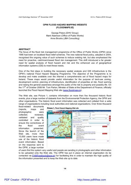
The Web site, see Picture 1, contains information on more then five thousand historic flood<br />
events, plus a large number of datasets from the Environmental Protection Agency, the <strong>OPW</strong> and<br />
other organisations. The historic flood event information was collected and collated from a wide<br />
range of organizations including local authorities and national organizations. Over three thousand<br />
flood-related documents<br />
(reports, maps and<br />
Picture 1, Flood Hazard Mapping Web site<br />
photographs) were<br />
collected, reviewed,<br />
validated and quality<br />
controlled in order to<br />
ensure the correctness of<br />
the flood event<br />
information presented.<br />
Since the launch of the<br />
Web site, more then<br />
10,000 users have made<br />
use of the historic flood<br />
event information. Based<br />
on the response sent to<br />
the <strong>OPW</strong>, a large number<br />
of users find the system very useful and people are sending in photographs and other information<br />
to be uploaded onto the Web site. The <strong>OPW</strong> has put in place an internal organization (to be<br />
contacted via FHMFeedback@opw.ie) for facilitating this in order to maintain the high quality of<br />
the information presented and to keep the Web site up to date.<br />
1/8<br />
PDF Creator - PDF4Free v2.0<br />
http://www.pdf4free.com
Irish Hydrology Seminar 13 th November 2007<br />
G.H.J. Peters (DHV Group)<br />
1. INTRODUCTION TO <strong>FLOOD</strong> <strong>MAPPING</strong><br />
1.1 <strong>FLOOD</strong>S DIRECTIVE<br />
Following devastating floods in several parts of Europe in recent years, EU environment ministers<br />
agreed in October 2004 that there was a need for greater European co-ordination on flood risk<br />
management. The European Commission produced a Floods Action Programme, which included<br />
the proposal for an EU Directive on the Assessment and Management of Flood Risks. This<br />
Directive (the ‘Floods’ or ‘Flood Risk Management’ Directive – 2007/60/EC) has been adopted<br />
and is due to come into force before the end of 2007. Under this Directive, a nationwide<br />
preliminary flood risk assessment will be required to identify areas that are, or could foreseeably<br />
become, subject to significant flood risk, using available or readily derivable information such as<br />
historic flood data. The next step under this EU Directive is the preparation of flood maps for all<br />
areas identified as being at risk and subsequently flood risk management plans are required for<br />
these areas. GIS tools will be essential in undertaking this assessment in spatially relating flood<br />
hazard information and potential risk receptors (location of properties, infrastructure, etc.).<br />
1.2 A NEW <strong>FLOOD</strong> POLICY AND A SPATIAL APPROACH FOR IRELAND<br />
Arising from changing perspectives on the approach to living with floods and managing flood risk,<br />
and following a series of major flood events, a full review of national flood policy was undertaken<br />
by an Inter-Departmental Review Group in Ireland. The review led to the production of a report<br />
(<strong>OPW</strong>, 2004) that summarised the work of the review group and set out a series of<br />
recommendations, which were subsequently adopted by Government in September 2004 to<br />
establish a new national flood management policy.<br />
The new policy is founded on a proactive and catchment-based approach to flood risk<br />
management, with an emphasis on the identification and management of potential future, as well<br />
as existing, flood risks. Whereas the development of flood relief schemes has focused primarily<br />
on small areas (i.e., a town and its immediate vicinity) where significant flooding was known to<br />
have previously occurred, the new policy necessitates a wider spatial analysis to identify existing<br />
and potential future flood risks, including those areas where serious flooding may not have<br />
occurred in the past.<br />
To implement the new policy, a number of work programmes are underway to develop the<br />
strategic information base necessary for the proactive identification and management of flood risk<br />
in line with the EU Floods Directive. Under these programmes, which include the Flood Studies<br />
Update and the Flood Mapping Programme, information is being developed on meteorology,<br />
hydrology and flood flows, land use, channel, floodplain and catchment topography, flood hazard<br />
and potential risk receptors. All of this information is essentially attributed spatial data and the use<br />
of GIS is increasingly becoming an essential tool for the management of these data - and hence<br />
flood risk - in Ireland.<br />
This paper will now focus on the Flood Mapping Programme, which is a core element of this new<br />
spatially-based approach, and under which the Phase I Project has now been completed.<br />
2. <strong>OPW</strong>’S <strong>FLOOD</strong> <strong>MAPPING</strong> PROGRAMME<br />
The need for identifying flood risk areas in Ireland has become more urgent over the past few<br />
decades. The country has suffered a number of major flood events in recent years (Hurricane<br />
Charlie 1986, February and November 2002, November 2004 etc) and current understanding of<br />
2/8<br />
PDF Creator - PDF4Free v2.0<br />
http://www.pdf4free.com
Irish Hydrology Seminar 13 th November 2007<br />
G.H.J. Peters (DHV Group)<br />
climate change indicates that flooding is likely to become worse in the future. The effect of this<br />
flooding varies widely and includes damage to residential, commercial and industrial property,<br />
disruption to traffic, business, farms, sewerage treatment and other services. On top of the<br />
current flooding problems, the effects of climate change and the pressure for development as a<br />
direct result of Ireland’s period of unprecedented economic growth are leading to mounting<br />
pressure for development on land that is increasingly at risk from flooding. All these conflicting<br />
factors have to be managed in a sustainable manner.<br />
In order to deal with this situation, the <strong>OPW</strong> made a strategic decision to start a programme for<br />
the development of flood hazard maps for Ireland. The objective of this programme was ultimately<br />
the development of predictive flood hazard maps, which would be prepared following hydrological<br />
and hydraulic analysis and modelling. The calibration and verification of the predictive information<br />
would however be dependent on the amount and quality of recorded historical data. A first step<br />
towards the development of these predictive maps would therefore have to include the collection,<br />
interpretation and verification of historic flood event information. Such information also has value<br />
in its own right and could be prepared for display at an order of cost lower than predictive<br />
mapping. The Flood Hazard Mapping programme has therefore been broken into two phases:<br />
Phase I, which will address historic data (and the development of a data management system),<br />
and Phase II that will cover the preparation and display of predictive mapping for the entire<br />
country.<br />
In 2004 the Office of Public commissioned ESBI to undertake Phase 1 of the programme, which<br />
is the development (and subsequent maintenance) of an Internet-based GIS Database system<br />
and the collection, review and uploading of all available historic flood event information in Ireland<br />
(a sample of which is shown in<br />
Picture 2). The Web-based GIS<br />
Database system was delivered<br />
to specification within two and a<br />
half years and within budget.<br />
The Phase I project was<br />
officially completed on the 17 th<br />
of October 2006 when Mr. Tom<br />
Parlon, Minister of State at the<br />
Department of Finance,<br />
launched the Flood Hazard<br />
Mapping Web site<br />
www.floodmaps.ie, although the<br />
<strong>OPW</strong> are keeping the site ‘live’<br />
with new information as floods<br />
occur in the future.<br />
Picture 2, Photograph Clancy's Strand Limerick Jan 2002, source Limerick City Council<br />
3. DEVELOPMENT OF WWW.<strong>FLOOD</strong>MAPS.<strong>IE</strong><br />
In most countries around the world, historic flood event information is not directly available and is<br />
therefore not easy accessible for interested parties. Some countries displaying predictive flood<br />
maps supply the underlying historical flood event information upon request. Because of the<br />
unique character of the system, the <strong>OPW</strong> was not in a position to rely on or learn from previous<br />
experience from abroad when drafting the Terms of Reference. This Section will give some<br />
details on the process of development of the Internet-based GIS Database system during Phase I<br />
3/8<br />
PDF Creator - PDF4Free v2.0<br />
http://www.pdf4free.com
Irish Hydrology Seminar 13 th November 2007<br />
G.H.J. Peters (DHV Group)<br />
of the Flood Hazard Mapping Programme. Different aspects of the system and the process of<br />
development will be discussed and commented on, namely:<br />
− Terms of Reference. The Terms of Reference contained a high level of detail for a large<br />
number of requirements, but let a sufficient amount of room for the consultants to make full<br />
use of their expertise. The consultants were asked to deliver a system to display historic<br />
flood event information and a number of GIS datasets.<br />
− Stakeholder Involvement. A large number of stakeholders was involved with the<br />
development of the system during regular (progress) meetings, consultation, workshops and<br />
test sessions.<br />
− System development. System performance was an important requirement for the<br />
consultant during system and hardware design. The system and its database had to have<br />
adequate capacity to store, manage and recover efficiently all flood data now and in the<br />
future.<br />
− Data. As part of the Flood Hazard Mapping Program a total of 52 source bodies (ca 300<br />
offices), including Local Authorities and National Organizations (e.g. Waterways Ireland,<br />
DoEHLG, Teagasc etc) were visited and over 2,000 man days were spent to collect, filter,<br />
review and upload this information onto the database.<br />
− Maintenance. As part of the contract, the consultant developed an easy to use Back End<br />
system for uploading and updating flood event data. The main focus during the design of this<br />
system was on how the <strong>OPW</strong> would carry out data maintenance in the future.<br />
3.1 TERMS OF REFERENCE<br />
The <strong>OPW</strong> prepared the technical specification for the development of the entire Flood Hazard<br />
Mapping System internally with the assistance of a stakeholder steering committee group. The<br />
Terms of Reference contained a high level of detail for a large number of requirements, but let a<br />
sufficient amount of room for the consultants to make full use of their expertise. In general terms,<br />
the System had to provide at least the following functionality;<br />
- Storage and recovery of flood information for historical (and predicted future) floods,<br />
including, but not limited to, point, line and aerial information, data, images, documents, etc.;<br />
- Dynamic display of the information as GIS layers, tables, images and reports;<br />
- Manipulation and filtering of the information according to the data fields, geographical<br />
attributes or associated metadata;<br />
- Printing and export facilities for the information;<br />
- A tiered access and associated functionality capability for different classification of users;<br />
- Links to other websites;<br />
- Access (according to clearance level) to the full range of information and functionality via<br />
the Internet;<br />
- Entry of future flood data from the regional <strong>OPW</strong> offices;<br />
- Compatibility with a range of GIS proprietary software, and;<br />
- Capacity for incorporation of further databases and/or GIS layers at a future date.<br />
3.2 STAKEHOLDER INVOLVEMENT<br />
The primary stakeholders of the programme are the local authorities, which have responsibility for<br />
a range of functions (spatial planning and land-use zoning, development control, planning of<br />
infrastructure and the development of emergency response programmes) that could be facilitated<br />
by the proposed maps. The maps will also provide valuable information in the management of<br />
flood risk and the identification and prioritisation of the need for flood relief works. Other<br />
significant stakeholders and potential beneficiaries of the programme included:<br />
4/8<br />
PDF Creator - PDF4Free v2.0<br />
http://www.pdf4free.com
Irish Hydrology Seminar 13 th November 2007<br />
G.H.J. Peters (DHV Group)<br />
- The Department of the Environment, Heritage and Local Government (DoEHLG), due to its<br />
role in planning and development policy and emergency planning;<br />
- The Department of Finance;<br />
- The Department of Communications, Marine and Natural Resources;<br />
- Engineers, for the planning and design of property and infrastructure;<br />
- Developers for identifying appropriate locations for development;<br />
- The ESB and Riparian Owners, for the management of certain rivers;<br />
- The Public, for general awareness of the risk to life and property;<br />
- The Insurance Industry, for the determination of flood risk and potential cost.<br />
It was essential that the Internet-based GIS Database System was developed, presented and<br />
made available in a way that would meet the needs of all these stakeholders. A Stakeholder<br />
Steering Group had been formed for the purposes of consultation on the structure and direction of<br />
the programme, and comprises representatives from the following organizations;<br />
- Office of Public Works;<br />
- Department of the Environment, Heritage and Local Government;<br />
- Department of Communications, Marine and Natural Resources;<br />
- County and City Manager’s Association;<br />
- Irish Planning Institute;<br />
- Institution of Engineers of Ireland;<br />
- Expert Advisors (Independent).<br />
The Stakeholder Steering Group was involved with the development of the technical specification<br />
for Phase I and assisted with the direction and monitoring of the project through consultation and<br />
regular progress meetings. A workshop was also held during the initial stages of the project with<br />
representatives from local authorities (planning and engineering departments) to provide early<br />
comment on the foreseen direction of the Project, and a large number of stakeholders were also<br />
involved in system testing.<br />
3.3 DATA<br />
The collection and uploading of historic flood event information ran in parallel with the<br />
development of the Internet-based GIS Database system. The type of information varied from<br />
photographs from flood events, to consultants’ reports, recordings from gauging stations,<br />
eyewitness accounts from staff plus letters from members of the public. The quality and reliability<br />
of the Web site strongly depends on the quality and reliability of the information provided and<br />
therefore it was an absolute condition for the <strong>OPW</strong> that collection, filtering, review and uploading<br />
of information was carried out to the highest standards. Every single piece of flood data is stored<br />
and referenced to its source.<br />
All information was logged in the database and files were stored digitally. Performance of the<br />
system was one of the major requirements in the contract and therefore the size of the different<br />
files had to be optimized and balanced with their graphical quality. One of the issues that had to<br />
be addressed was copyright. The historic flood event information had been sourced internally in<br />
the <strong>OPW</strong> and 52 different source bodies. Before the launch of the Web site, each of the source<br />
bodies was given the opportunity to review their information in the format as it would be<br />
presented on the Web site. At that stage, each of the source bodies was given the option to<br />
withdraw any (parts) of the information items for reasons of copyright, confidentiality, sensitivity or<br />
other reasons.<br />
5/8<br />
PDF Creator - PDF4Free v2.0<br />
http://www.pdf4free.com
Irish Hydrology Seminar 13 th November 2007<br />
G.H.J. Peters (DHV Group)<br />
3.4 SYSTEM DEVELOPMENT<br />
The Web GIS application as developed is a complete data management solution, comprising not<br />
only the web GIS mapping system, but also including editing and data upload through a<br />
controlled-access data administration system behind the scenes. The website handles diverse<br />
levels of access from public Internet as well as <strong>OPW</strong> Intranet and Extranet (Citrix MetaFrame)<br />
users. The large number of stakeholders involved from the outset of the Project, both in<br />
contributing data and in consultation with the developers over the design and acceptance of the<br />
final system, presented its own challenges in managing the expectations and requirements of so<br />
many diverse stakeholders and in designing a web GIS to meet these requirements.<br />
One of the technical challenges faced was how to represent a flood on the map given the diverse<br />
range of information possible, from very detailed data including extents, levels and peak times to<br />
verbal descriptions based on recollections of recurring flooding. How do you symbolise an event<br />
that takes place over a period of time ranging from hours to weeks in sometimes numerous<br />
locations along a watercourse? Decisions like these were debated amongst the stakeholders until<br />
a practical solution was arrived at. In the final solution, flood events are represented as point<br />
symbols unless a digitised polygon exists for the flood boundary (but there are relatively few of<br />
these). The point symbols denote the fact that information exists (in the form of photos or a report)<br />
which refers to flooding at the named location on the map. The point symbol is therefore only<br />
indicative of a risk of flooding at any location and is not meant to be accurate at the scale of<br />
individual properties. Each flood event and each report is quality coded, categorised and ranked<br />
in order to qualify the type of information that describes it or is presented, thus giving more<br />
emphasis to data describing the level or extent of flood events and less to data with more general<br />
descriptions on flood events.<br />
Because of this large variety in quality of the historic flood event information presented (plus that<br />
the majority of it had been sourced from outside the <strong>OPW</strong>), the web sites disclaimer had to cover<br />
all aspects on the system’s coverage, accuracy, reliability, but also includes statements on liability<br />
and copyright issues. Directly after entering the system via either the general access option or the<br />
registered users option the user will be asked to read the website’s disclaimer and to accept its<br />
content. Users won’t be able to access the information contained in the System in any way other<br />
than by accepting the conditions of use of the information and associated disclaimers.<br />
The system’s main web page is presented directly after accepting the text of the disclaimer. The<br />
system has been designed with two different sets of tools for locating flood event information and<br />
GIS for the user’s geographical area of interest. Users can search by selecting a county, town,<br />
townland and even street names for the larger cities in the country. Another option is to search by<br />
catchment or river and if preferred, users can enter the letter and digits of a National Grid<br />
Reference number. Within these queries, users can further refine their search, restricting the<br />
scope of their search within a time period, geographical buffer or requirements on the quality of<br />
the flood reports. A different option of retrieving the information is to use the system’s mapping<br />
tools. Users can zoom and pan to their area of interest on the map and (marquee) select flood<br />
information system. Independent from the type of search conducted, the system will display all<br />
historic flood events plus its supporting information like reports, photographs and press articles.<br />
Users can then decide to drill down further and to open the underlying supporting information,<br />
copy it onto their own systems etc. A reporting tool is included for the generation of summary<br />
reports including both a map and a list of the supporting information. A simple Help window with<br />
mouse-over pop-up text is effective in providing guidance on the use of the system without the<br />
need for training.<br />
6/8<br />
PDF Creator - PDF4Free v2.0<br />
http://www.pdf4free.com
Irish Hydrology Seminar 13 th November 2007<br />
G.H.J. Peters (DHV Group)<br />
3.5 MAINTENANCE<br />
Since the launch of the Flood Hazard Mapping Web site the <strong>OPW</strong> is in charge of the<br />
management of the data system and they have to ensure that the information on floods and<br />
related datasets is kept up to date. A number of users of the Web site have already sent their<br />
feedback and new data on flood events. New flood events occur (e.g. November 2006 and a<br />
large number of smaller events during the past year) and have to be logged in and uploaded onto<br />
the system. In order to ensure easy maintenance of the Flood Hazard Mapping System (including<br />
its historical flood event database), the consultant was asked to develop an easy to use back end<br />
system.<br />
The main focus of the design of this system was on how the <strong>OPW</strong> would carry out data<br />
maintenance in the future. At an early stage in the project it was decided that the actual uploading<br />
of new data and modifications to existing datasets could best done in the regional offices, since<br />
local expertise and contacts would be essential when working with flood event information. At the<br />
same time, the quality and reliability of the data as presented had to be guaranteed. In order to<br />
ensure ease of use and different levels of security a two-tiered system was developed. New data<br />
can be uploaded and existing data can be modified in each of the regional offices, but will only be<br />
presented on the live system after a data administrator gives his approval. By applying this twotiered<br />
system, most of the work can be done regionally, while no interference is made with the<br />
real live data. Regional staff can upload data via the easy to use Access Database front end and<br />
store data at a temporary storage area on the Oracle Database. Upon receipt of the approval<br />
from the data administrator this is transferred from this location to the live database and is<br />
presented on the web site.<br />
4. FUTURE DEVELOPMENTS<br />
The Flood Mapping System developed under the Phase I project currently displays historic flood<br />
event information. In line with their new flood policy (and the EU Floods Directive) the <strong>OPW</strong> are<br />
currently preparing for the next step. Flood hazard, risk maps and management plans will be<br />
developed for those areas identified as being of potentially significant risk. A number of pilot<br />
Catchment Flood Risk Assessment and Management (CFRAM) Studies (for the River Dodder,<br />
Lee, Suir, etc.), which are the vehicle through which such maps and plans will be developed,<br />
have been started over the past two years. The results from these pilot studies will be evaluated<br />
and used during the process of drafting the specifications for the national CFRAM Study<br />
programme.<br />
The Flood Mapping System will continue to be the public portal for flood mapping information,<br />
including the predictive maps. As significant spatial coverage of predictive mapping is achieved,<br />
the format of the System and website will however be amended to present the predictive maps as<br />
the default view, but with the historic data remaining available as supplementary information.<br />
It is likely that the reporting under the ‘Flood Risk Management’ Directive at a European level will,<br />
along with that for the Water Framework Directive and other related legislation, be via the WISE<br />
(Water Information System for Europe) system under development by the European Commission.<br />
This spatial and database system will provide centralised public access to flood and other waterrelated<br />
information for the whole of the EU and, along with the INSPIRE Directive (2007/2/EC),<br />
will set requirements for the format and content of spatial data produced under the flood risk<br />
management programme.<br />
7/8<br />
PDF Creator - PDF4Free v2.0<br />
http://www.pdf4free.com
Irish Hydrology Seminar 13 th November 2007<br />
G.H.J. Peters (DHV Group)<br />
5. SUMMARY<br />
Over the past years a number of programmes have been initiated by <strong>OPW</strong> for the development of<br />
a strategic information base necessary for the proactive identification and management of flood<br />
risk. Under these programmes, which include the Flood Studies Update and the Flood Mapping<br />
Programme, information is being developed on meteorology, hydrology, flood flows, land use,<br />
channel, floodplain and catchment topography, flood hazard and potential risk receptors.<br />
The change of focus of <strong>OPW</strong>’s flood risk management programme from localised flood relief<br />
schemes to a more catchment based approach with more emphasize on proactive flood risk<br />
management, introduced a far greater need for spatial analysis of flood hazard and risk and the<br />
enhanced use of geographical information systems (GIS) to meet these needs. Whereas the<br />
development of flood relief schemes primarily focused on small areas like towns where significant<br />
flooding was known to have previously occurred, the new policy necessitates a wider spatial<br />
analysis to the identify existing and potential future flood risks, including those areas where<br />
serious flooding may not have occurred in the past. All of this information is essentially attributed<br />
spatial data and the use of GIS is increasingly becoming an essential tool for the management of<br />
these data and hence flood risks in Ireland.<br />
One of the first steps in building this necessary spatial analysis and GIS infrastructure was<br />
<strong>OPW</strong>’s national Flood Hazard Mapping Programme. The objective of this programme was to<br />
develop and make available over the internet a comprehensive set of flood hazard maps for<br />
Ireland. These maps would provide useful information for the purpose of land-use zoning,<br />
development control, planning of infrastructure, identification of properties at risk, flood warning<br />
and raising the general awareness amongst the public of the risk to property and possibly life. On<br />
the 17 th of October 2006 Mr. Tom Parlon, Minister of State at the Department of Finance, officially<br />
launched the Flood Hazard Mapping Web site (www.floodmaps.ie).<br />
REFERENCES<br />
The Office of Public Works (2004), Report of the Flood Policy Review Group<br />
8/8<br />
PDF Creator - PDF4Free v2.0<br />
http://www.pdf4free.com


