

DEVELOPMENT OF FLOOD MAPPING FORMATS FOR THE LEE ...
DEVELOPMENT OF FLOOD MAPPING FORMATS FOR THE LEE ...
DEVELOPMENT OF FLOOD MAPPING FORMATS FOR THE LEE ...

Create successful ePaper yourself
Turn your PDF publications into a flip-book with our unique Google optimized e-Paper software.
Irish National Hydrology Conference 2008<br />
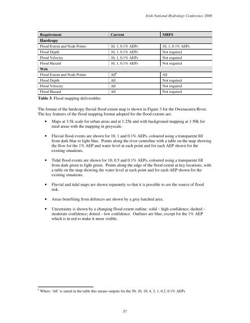
Requirement Current MRFS<br />
Hardcopy<br />
Flood Extent and Node Points 10, 1, 0.1% AEPs 10, 1, 0.1% AEPs<br />
Flood Depth 10, 1, 0.1% AEPs Not required<br />
Flood Velocity 10, 1, 0.1% AEPs Not required<br />
Flood Hazard 10, 1, 0.1% AEPs Not required<br />
Web<br />
Flood Extent and Node Points All 6 All<br />
Flood Depth All Not required<br />
Flood Velocity All Not required<br />
Flood Hazard All Not required<br />
Table 3: Flood mapping deliverables<br />
The format of the hardcopy fluvial flood extent map is shown in Figure 3 for the Owenacurra River.<br />
The key features of the flood mapping format adopted for the flood extents are:<br />
• Maps at 1:5k scale for urban areas and at 1:25k and with background mapping at 1:50k for<br />
rural areas with the mapping in greyscale.<br />
• Fluvial flood events are shown for 10, 1 and 0.1% AEPs, coloured using a transparent fill<br />
from dark blue to light blue. Points along the river centreline with a table on the map showing<br />
the flow for the 1% AEP and water level at each point and for each AEP shown for the<br />
existing situations.<br />
• Tidal flood events are shown for 10, 0.5 and 0.1% AEPs, coloured using a transparent fill<br />
from dark green to light green. Points along the edge of the flood extent at key locations, with<br />
a table on the map showing the water level at each point and for each AEP shown for the<br />
existing situations.<br />
• Fluvial and tidal maps are shown separately so that it is possible to see the source of flood<br />
risk.<br />
• Areas benefiting from defences are shown by a grey hatched area.<br />
• Uncertainty is shown by a changing flood extent outline: solid – high confidence; dashed –<br />
moderate confidence; dotted – low confidence. Outlines are blue, except for the 1% AEP<br />
which is in red to make it more visible.<br />
6 Where ‘All’ is stated in the table this means outputs for the 50, 20, 10, 4, 2, 1, 0.2, 0.1% AEPs<br />
57


