JOHAN & ADRI SNYMAN'S DAMARALAND TRIP REPORT : 7 - 10 ...
JOHAN & ADRI SNYMAN'S DAMARALAND TRIP REPORT : 7 - 10 ...
JOHAN & ADRI SNYMAN'S DAMARALAND TRIP REPORT : 7 - 10 ...

You also want an ePaper? Increase the reach of your titles
YUMPU automatically turns print PDFs into web optimized ePapers that Google loves.
<strong>JOHAN</strong> & <strong>ADRI</strong> SNYMAN’S <strong>DAMARALAND</strong> <strong>TRIP</strong> <strong>REPORT</strong> : 7 - <strong>10</strong> DECEMBER 2012<br />
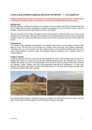
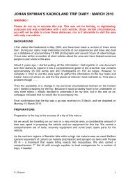
Background<br />
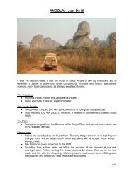
This trip was undertaken to collect the last photographs needed to complete my book on Damaraland.<br />
It was therefore not undertaken for recreational purposes and we travelled in a solo vehicle. Under<br />
normal circumstances, it is not advisable to visit the area with only one vehicle.<br />
Preparations<br />
Our Landy is extensively equipped for overland travel and no work was required to prepare it for the<br />
trip. We carry a comprehensive set of tools, recovery equipment, some basic spare parts, and a very<br />
comprehensive first aid kit. We therefore only packed our camera equipment, a laptop computer,<br />
clothes, and enough food and drink for the trip. As we would be travelling on our own in a very remote<br />
area, we had pre-arranged back-up services in place as well as reliable means of communication.<br />
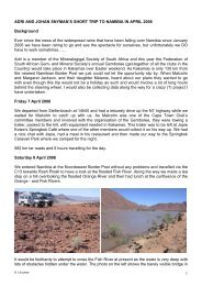
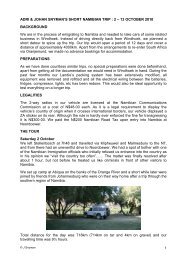
Friday 7 December<br />
We left Windhoek after work and travelled along the B1 to Okahandja, the B2 to Usakos and then the<br />
D1918 until we reached a track down a dry riverbed to our campsite for the night.<br />
314km for the day (243km on tar and km on 71gravel) and our travelling time was 4¾hours.<br />
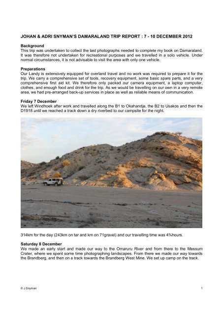
Saturday 8 December<br />
We made an early start and made our way to the Omaruru River and from there to the Messum<br />
Crater, where we spent some time photographing landscapes. From there we made our way towards<br />
the Brandberg, and then on a track towards the Brandberg West Mine. We set up camp on the track.<br />
© J Snyman 1
© J Snyman 2
227km for the day (all of it on gravel, sand and rocky roads and tracks).<br />
Sunday 9 December<br />
After a quiet and, surprisingly, cold night, we made our way across the mountain range to east of the<br />
old Brandberg West mine to the Ugab River and then made our way over Divorce Pass to the Doros<br />
Crater.<br />
© J Snyman 3
© J Snyman 4
We circumnavigated the Crater in an anti-clockwise direction before making our way to the Klein Gai-<br />
As Fountain and then down a dry riverbed towards the Ugab River. When we reached our intended<br />
campsite, there were fresh lion tracks all over the place and we continued south for several km’s<br />
before setting up our camp for the night.<br />
© J Snyman 5
138km for the day (all of it on gravel, sand and rocky roads and tracks) and our travelling time was ---<br />
hours.<br />
Monday <strong>10</strong> December<br />
After a very quiet night, it was time to head for home .... but obviously via a scenic route and not the<br />
shortest one either. We made our way to the D2303 and from there to the coast and then followed the<br />
C34 to Henties Bay, Swakopmund and Walvisbay and then on the C14 over Kuiseb Pass and the C26<br />
over Gamsberg Pass to Windhoek.<br />
© J Snyman 6
646km for the day (69km on tar and 567km on gravel, sand and rocky roads and tracks) and our<br />
travelling time was <strong>10</strong>½hours.<br />
Conclusion<br />
This was yet another memorable trip with my favourite travelling companion to a spectacular part of<br />
Namibia.<br />
We drove a total distance of 1325km, of which 312km was on tarred roads and <strong>10</strong>13km was on<br />
gravel, sand and rocky tracks. We did not see a single person or vehicle, not even in the distance,<br />
from the time we turned off the B2 on Friday until we turned onto the C34 on Monday – just the way<br />
we prefer and like it.<br />
As far as the book is concerned, this is mission accomplished ! The is still a bit of work to be done –<br />
mainly the selection and insertion of a few photographs and a final proof read, before the manuscript<br />
goes to the editor, the people doing the design and layout, and then the printers. I hope to have the<br />
first copies in my hand early in the New Year.<br />
Some statistics about our travels for this book :<br />
Although we’ve travelled in, and through, the Damaraland on numerous occasions over the past 18<br />
years, the actual work on the book started in August 2011 when I started verifying all the data I had,<br />
logging all the roads and tracks and photographing all the places of interest and commonly seen<br />
species of fauna and flora, etc.<br />
© J Snyman 7
From August 2011 to December 2012 we drove a distance of 23431km….. some of it in very desolate<br />
areas. There were many occasions where we travelled across extremely harsh terrain from dawn to<br />
dusk and we pitched our tent where and when we ran out of light. As it would be impractical to take<br />
other people along on these trips, all of this travelling was undertaken in a solo vehicle with only each<br />
other for company.<br />
We did most of the travelling with our Defender, but also confirmed the viability of undertaking some of<br />
the proposed routes in the book with Adri’s Daihatsu Terios and our Isuzu.<br />
© J Snyman 8
During this time we have had no vehicle or tyre problems that could not be resolved on the spot. We<br />
got stuck in the riverbeds a few times, bur always managed to extricate ourselves without outside<br />
assistance.<br />
© J Snyman 9
Apart from a few nights spent at formal accommodation options, we slept in the veld in our rooftop tent<br />
for 44 nights at some very amazing places. We were also fortunate that we never experienced any<br />
problems with people or wild animals, such as elephant or lions.<br />
© J Snyman <strong>10</strong>
We also took 12649 photographs – most of them by Adri.<br />
© J Snyman 11
© J Snyman 12
© J Snyman 13