EOC sample questions
EOC sample questions
EOC sample questions

You also want an ePaper? Increase the reach of your titles
YUMPU automatically turns print PDFs into web optimized ePapers that Google loves.
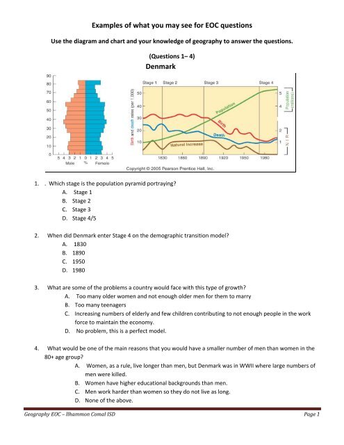
Examples of what you may see for <strong>EOC</strong> <strong>questions</strong><br />
Use the diagram and chart and your knowledge of geography to answer the <strong>questions</strong>.<br />
(Questions 1– 4)<br />
Denmark<br />
1. . Which stage is the population pyramid portraying?<br />
A. Stage 1<br />
B. Stage 2<br />
C. Stage 3<br />
D. Stage 4/5<br />
2. When did Denmark enter Stage 4 on the demographic transition model?<br />
A. 1830<br />
B. 1890<br />
C. 1950<br />
D. 1980<br />
3. What are some of the problems a country would face with this type of growth?<br />
A. Too many older women and not enough older men for them to marry<br />
B. Too many teenagers<br />
C. Increasing numbers of elderly and few children contributing to not enough people in the work<br />
force to maintain the economy.<br />
D. No problem, this is a perfect model.<br />
4. What would be one of the main reasons that you would have a smaller number of men than women in the<br />
80+ age group?<br />
A. Women, as a rule, live longer than men, but Denmark was in WWII where large numbers of<br />
men were killed.<br />
B. Women have higher educational backgrounds than men.<br />
C. Men work harder than women so they do not live as long.<br />
D. None of the above.<br />
Geography <strong>EOC</strong> – llhammon Comal ISD Page 1
Examples of what you may see for <strong>EOC</strong> <strong>questions</strong><br />
Use the pictures and your knowledge of geography to answer the <strong>questions</strong>. (Questions 5– 8)<br />
Levels of Development and Economic Activities<br />
A. B.<br />
C. D.<br />
Each of the above photos shows a different level of development and economic activities. Match the picture with its<br />
description.<br />
5. This photo is showing quaternary activities.<br />
6. This photo is showing secondary activities.<br />
7. This photo is showing primary activities.<br />
8. This photo is showing tertiary activities.<br />
Geography <strong>EOC</strong> – llhammon Comal ISD Page 2
Examples of what you may see for <strong>EOC</strong> <strong>questions</strong><br />
Use the map and your knowledge of geography to answer the following question. (Question 9)<br />
9. Biomes are groups of ecosystems with similar climates and organisms. What biome is this map showing?<br />
A. tropical rainforests<br />
B. deserts<br />
C. grasslands<br />
D. boreal forests<br />
On a daily basis, 250,000 people are added to earth’s population. Most are born into nations in the<br />
developing world. Tragically, that means that one person in five lives in absolute poverty. One of the<br />
results of such deprivation is that almost one billion people in today’s world can neither read nor write,<br />
and the numbers are growing. As a result, they are forced to live in subsistence economies.<br />
10. Based on the information in the above paragraph, what is a characteristic of the developing world?<br />
A. low birthrates<br />
B. stable infant mortality rates<br />
C. low rates of literacy<br />
D. stable political conditions<br />
Geography <strong>EOC</strong> – llhammon Comal ISD Page 3
Examples of what you<br />
may see for <strong>EOC</strong> <strong>questions</strong><br />
11. What geographic phenomenon is most responsible for the constant threat of earthquakes in several parts of<br />
North America?<br />
A.<br />
Magma underneath the<br />
earth’s surface is pressing up on the crust with increasing pressure.<br />
B. The Pacific plate and the North American plate are presently scraping past each other at the rate of<br />
several centimeters per<br />
year.<br />
C. Pressure from increased<br />
ocean masss caused by global warming is creating structural instability<br />
underneath the continent.<br />
D.<br />
Great quantities of industrial chemicals have leached into the earth’s crust,<br />
causing a breakdown in<br />
its composition.<br />
12. Based on the diagram and your knowledge of geography what process is taking place?<br />
A. Deforestation cycle<br />
B. Desertification cycle<br />
C. Glaciations cycle<br />
D. Hydrological cycle<br />
Geography <strong>EOC</strong> – llhammon Comal ISD<br />
Page 4
Examples of what you may see for <strong>EOC</strong> <strong>questions</strong><br />
Use the map and your knowledge of geography to answer the question. (Question 13)<br />
World Time Zones<br />
13. The world’s 22 standard time zones are often depicted using which projection.<br />
A. conic<br />
B. Mercator<br />
C. Robinson<br />
D. flat plane<br />
Geography <strong>EOC</strong> – llhammon Comal ISD Page 5
Examples of what you may see for <strong>EOC</strong> <strong>questions</strong><br />
Use the diagram and your knowledge of geography to answer the following <strong>questions</strong>.<br />
14. What type of climate does this area have?<br />
A. desert<br />
B. subarctic<br />
C. marine west coast<br />
D. steppe<br />
15. Which of the following would not have the type of climate shown on this climograph?<br />
A. Europe<br />
B. North America<br />
C. Antarctica<br />
D. J. South America<br />
16. Which description best describes the climate type shown on the climograph?<br />
A. snow and ice year‐round.<br />
B. cool, rainy winters.<br />
C. semi‐arid, hot summers.<br />
D. warm year round<br />
Geography <strong>EOC</strong> – llhammon Comal ISD Page 6