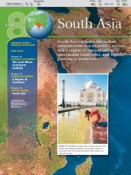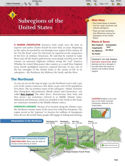
Subregions of the United States
Subregions of the United States
Subregions of the United States

You also want an ePaper? Increase the reach of your titles
YUMPU automatically turns print PDFs into web optimized ePapers that Google loves.
145-149-Chapter6 10/16/02 10:18 AM Page 145<br />
<strong>Subregions</strong> <strong>of</strong> <strong>the</strong><br />
<strong>United</strong> <strong>States</strong><br />
A HUMAN PERSPECTIVE America’s back roads were <strong>the</strong> beat <strong>of</strong><br />
reporter and author Charles Kuralt for more than 20 years. Beginning<br />
in <strong>the</strong> 1960s, he traveled by van through every region <strong>of</strong> <strong>the</strong> country. In<br />
his “On <strong>the</strong> Road” series for television, he reported on <strong>the</strong> uniqueness<br />
<strong>of</strong> <strong>the</strong> lives <strong>of</strong> ordinary Americans. He said that he wanted to make<br />
<strong>the</strong>se trips <strong>of</strong>f <strong>the</strong> beaten path because most people traveled across <strong>the</strong><br />
country on interstate highways without seeing <strong>the</strong> “real” America.<br />
Whe<strong>the</strong>r he visited Minnesota’s lake country or a small New England<br />
town, Kuralt spotlighted America’s regional diversity. In fact, one <strong>of</strong><br />
<strong>the</strong> key strengths <strong>of</strong> <strong>the</strong> <strong>United</strong> <strong>States</strong> is <strong>the</strong> variety <strong>of</strong> life in its<br />
subregions—<strong>the</strong> Nor<strong>the</strong>ast, <strong>the</strong> Midwest, <strong>the</strong> South, and <strong>the</strong> West.<br />
The Nor<strong>the</strong>ast<br />
As you can see on <strong>the</strong> map on page 134, <strong>the</strong> Nor<strong>the</strong>ast covers only 5 per<br />
cent <strong>of</strong> <strong>the</strong> nation’s land area. But about 20 per cent <strong>of</strong> <strong>the</strong> population<br />
lives <strong>the</strong>re. The six nor<strong>the</strong>rn states <strong>of</strong> <strong>the</strong> subregion—Maine, Vermont,<br />
New Hampshire, Massachusetts, Rhode Island, and Connecticut—are<br />
called New England. The o<strong>the</strong>r three—Pennsylvania, New York, and<br />
New Jersey—are sometimes referred to as Middle Atlantic states.<br />
(Maryland and Delaware, which are included in <strong>the</strong> South in this book,<br />
are sometimes included in <strong>the</strong> Middle Atlantic states.)<br />
AMERICA’S GATEWAY Because <strong>of</strong> its location along <strong>the</strong> Atlantic coast,<br />
<strong>the</strong> Nor<strong>the</strong>ast contains many <strong>of</strong> <strong>the</strong> areas first settled by Europeans. The<br />
region served as <strong>the</strong> “gateway” to America for millions <strong>of</strong> immigrants<br />
from all over <strong>the</strong> world. Many people still engage in fishing and farming,<br />
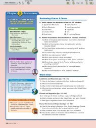
Main Ideas<br />
• The <strong>United</strong> <strong>States</strong> is divided<br />
into four major economic and<br />
cultural subregions.<br />
• There are both similarities<br />
and differences among <strong>the</strong><br />
subregions <strong>of</strong> <strong>the</strong> <strong>United</strong><br />
<strong>States</strong>.<br />
Places & Terms<br />
New England<br />
megalopolis<br />
<strong>the</strong> Midwest<br />
<strong>the</strong> South<br />
metropolitan<br />
area<br />
<strong>the</strong> West<br />
Connect to <strong>the</strong> Issues<br />
diverse societies While<br />
diversity can be a strength, it<br />
has also been <strong>the</strong> cause <strong>of</strong><br />
tension and conflict among<br />
regions.<br />
LOCATION BosWash is <strong>the</strong> name<br />
given to <strong>the</strong> highly urbanized<br />
nor<strong>the</strong>astern seaboard <strong>of</strong> <strong>the</strong><br />
<strong>United</strong> <strong>States</strong>.<br />
Urbanization in <strong>the</strong> Nor<strong>the</strong>ast<br />
Washington, D.C.<br />
pop. 523,800<br />
Philadelphia<br />
pop. 1,452,300<br />
New York<br />
pop. 7,405,400<br />
Boston<br />
pop. 559,100<br />
90 minutes<br />
60-90 minutes<br />
60 minutes<br />
SKILLBUILDER: Interpreting Graphics<br />
ANALYZING DATA Which cities are within 60<br />
minutes <strong>of</strong> each o<strong>the</strong>r by air travel?<br />
60 minutes<br />
35 minutes<br />
60 minutes<br />
Highly urbanized areas<br />
0<br />
75 150 miles<br />
0 75 150 kilometers<br />
Average Airplane Travel Times<br />
145
145-149-Chapter6 10/16/02 10:18 AM Page 146<br />
as <strong>the</strong> Nor<strong>the</strong>ast’s early settlers did. But <strong>the</strong> region’s coastal and inland<br />
waters turned it into <strong>the</strong> heart <strong>of</strong> trade, commerce, and industry for <strong>the</strong><br />
nation. In fact, <strong>the</strong> Nor<strong>the</strong>ast is one <strong>of</strong> <strong>the</strong> most heavily industrialized and<br />
urbanized areas in <strong>the</strong> world. The Atlantic seaboard cities <strong>of</strong> Philadelphia,<br />
Boston, and New York City serve as international trade centers.<br />
Coal, iron ore, and oil—found mainly in Pennsylvania—fueled <strong>the</strong><br />
industrialization <strong>of</strong> <strong>the</strong> region. Traditional industries, such as iron and<br />
steel, petroleum, and lumber, still play a role in <strong>the</strong> region’s economy.<br />
But most Nor<strong>the</strong>asterners are now employed in such manufacturing<br />
and service industries as electronics, communications, chemicals, medical<br />
research, finance, and tourism. Pennsylvania, New York, and New<br />
Jersey have rich farmlands, but much <strong>of</strong> New England is too hilly or<br />
rocky to grow crops easily.<br />
Parts <strong>of</strong> <strong>the</strong> Middle Atlantic states are <strong>of</strong>ten referred to as <strong>the</strong> “rust<br />
belt” because <strong>of</strong> <strong>the</strong>ir declining and abandoned traditional industries.<br />
They share this term with some <strong>of</strong> <strong>the</strong> states <strong>of</strong> <strong>the</strong> Midwest. In recent<br />
times, many “rust belt” industries have moved to <strong>the</strong> warmer climates<br />
<strong>of</strong> <strong>the</strong> “sunbelt” in <strong>the</strong> South and West.<br />
GROWTH OF THE MEGALOPOLIS The nation’s first megalopolis developed<br />
in <strong>the</strong> Nor<strong>the</strong>ast. A megalopolis is a region in which several large<br />
cities and surrounding areas grow toge<strong>the</strong>r. You can see <strong>the</strong> extent <strong>of</strong> <strong>the</strong><br />
“BosWash” megalopolis, as it is called, in <strong>the</strong> illustration on page 145.<br />
Using <strong>the</strong> Atlas<br />
Refer to <strong>the</strong><br />
map on page 106.<br />
What economic<br />
activities are<br />
shown for <strong>the</strong><br />
Nor<strong>the</strong>ast?<br />
A. Answer<br />
commercial farming<br />
and fishing,<br />
forestry, and<br />
manufacturing<br />
and trade<br />
Population Increase by State, 1990–2000<br />
120°W<br />
110°W<br />
100°W<br />
90°W 80°W 70°W<br />
60°N 70°N<br />
180°<br />
170°W<br />
PACIFIC<br />
ALASKA<br />
PACIFIC<br />
OCEAN<br />
0 OCEAN<br />
250 500 miles<br />
160°W<br />
0 250 500 kilometers<br />
Azimuthal Equal–Area Projection<br />
More than 30%<br />
20% to 29%<br />
10% to 19%<br />
Less than 10%<br />
Arctic Circle<br />
PACIFIC<br />
OCEAN<br />
CALIF.<br />
0<br />
250 500 miles<br />
0 250 500 kilometers<br />
Azimuthal Equal–Area Projection<br />
WASH.<br />
ORE.<br />
NEV.<br />
IDAHO<br />
UTAH<br />
ARIZ.<br />
MONT.<br />
WYO.<br />
COLO.<br />
N.M.<br />
N.D.<br />
S.D.<br />
NEBR.<br />
KANS.<br />
OKLA.<br />
TEX.<br />
MINN.<br />
IOWA<br />
MO.<br />
ARK.<br />
LA.<br />
WIS.<br />
ILL.<br />
MICH.<br />
IND.<br />
KY.<br />
TENN.<br />
MISS. ALA.<br />
OHIO<br />
W.<br />
VA.<br />
S.C.<br />
GA.<br />
FLA.<br />
ME.<br />
VT. N.H.<br />
MASS.<br />
N.Y.<br />
R.I. 40°N<br />
CONN.<br />
PA.<br />
N.J.<br />
DEL.<br />
MD.<br />
VA.<br />
N.C.<br />
ATLANTIC<br />
OCEAN<br />
30°N<br />
22°N<br />
PACIFIC<br />
Tropic <strong>of</strong><br />
Cancer<br />
OCEAN<br />
20°N<br />
HAWAII<br />
N<br />
20°N<br />
0 75 150 miles<br />
0 75 150 kilometers<br />
160°W 158°W<br />
156°W 154°W<br />
W<br />
S<br />
E<br />
SKILLBUILDER: Interpreting Maps<br />
PLACE Which states had population increases <strong>of</strong> more than<br />
30 percent?<br />
REGION Which region had <strong>the</strong> lowest increase in population?<br />
146 CHAPTER 6
145-149-Chapter6 10/16/02 10:18 AM Page 147<br />
It stretches through 500 miles <strong>of</strong> highly urbanized areas from Boston in<br />
<strong>the</strong> north to Washington, D.C., <strong>the</strong> national capital, in <strong>the</strong> south. It contains<br />
one-sixth <strong>of</strong> <strong>the</strong> U.S. population. New York City, <strong>the</strong> country’s cultural<br />
and financial center, is located here. Rapid road, rail, and air links<br />
have been vital to its economic development and expansion into <strong>the</strong><br />
South. You will read more about urban growth in Chapter 8.<br />
The Midwest<br />
The subregion that contains <strong>the</strong><br />
12 states <strong>of</strong> <strong>the</strong> north-central<br />
<strong>United</strong> <strong>States</strong> is called <strong>the</strong><br />
Midwest. Because <strong>of</strong> its central<br />
location, <strong>the</strong> Midwest is called <strong>the</strong><br />
American heartland. It occupies<br />
about one-fifth <strong>of</strong> <strong>the</strong> nation’s<br />
land and almost one-fourth <strong>of</strong> its<br />
people live <strong>the</strong>re. Since <strong>the</strong> Revolutionary<br />
War, immigrants from<br />
all over <strong>the</strong> world have made it<br />
<strong>the</strong>ir destination. Many early settlers<br />
came from Britain, Germany,<br />
and Scandinavia. Vast, largely flat<br />
plains are a distinctive feature <strong>of</strong><br />
<strong>the</strong> region. So are numerous<br />
waterways, including <strong>the</strong> Great<br />
Lakes and <strong>the</strong> Mississippi River<br />
and its many tributaries.<br />
The Changing Face <strong>of</strong> U.S. Agriculture<br />
1950 1990<br />
Farm Population: 25 million 4.6 million<br />
Number <strong>of</strong> Farms: 5.3 million 2.1 million<br />
Average Farm Size: 216 acres 461 acres<br />
B. Answer They<br />
are near bodies <strong>of</strong><br />
water.<br />
Making<br />
Comparisons<br />
What do <strong>the</strong><br />
major cities <strong>of</strong> <strong>the</strong><br />
Midwest have in<br />
common with<br />
those <strong>of</strong> <strong>the</strong><br />
Nor<strong>the</strong>ast?<br />
AGRICULTURAL AND INDUSTRIAL HEARTLAND The Midwest is <strong>the</strong><br />
nation’s “breadbasket.” Fertile soil, adequate rainfall, and a favorable climate<br />
enable Midwesterners to produce more food and feed more people<br />
than farmers in any comparable area in <strong>the</strong> world. Among <strong>the</strong> main products<br />
are corn, wheat, soybeans, meat, and dairy goods. Agriculture also is<br />
<strong>the</strong> foundation for many <strong>of</strong> <strong>the</strong> region’s industries, including meatpacking,<br />
food processing, farm equipment, and grain milling. O<strong>the</strong>r traditional<br />
industries are steel and automaking.<br />
Its central location and excellent waterways make <strong>the</strong> Midwest a trade,<br />
transportation, and distribution center. Chicago, Illinois, which is located<br />
near <strong>the</strong> southwestern shores <strong>of</strong> Lake Michigan, is <strong>the</strong> cultural, financial,<br />
and transportation hub <strong>of</strong> <strong>the</strong> Midwest. Most <strong>of</strong> <strong>the</strong> region’s major cities<br />
developed near large bodies <strong>of</strong> water, which were essential for early transportation.<br />
Cleveland, Detroit, Chicago, and Milwaukee grew near <strong>the</strong><br />
Great Lakes, and Cincinnati, St. Louis, Minneapolis, St. Paul, Kansas City,<br />
and Omaha developed along rivers.<br />
CHANGING FACE OF THE MIDWEST Like o<strong>the</strong>r regions, <strong>the</strong> Midwest<br />
is changing. The number <strong>of</strong> farms is declining. More Midwesterners are<br />
now employed in providing services than in traditional industries. The<br />
region’s metropolitan areas are expanding as urban dwellers and businesses<br />
leave <strong>the</strong> central cities for <strong>the</strong> suburbs. People and industries are<br />
also moving to <strong>the</strong> warmer South and West.<br />
<strong>Subregions</strong> <strong>of</strong> <strong>the</strong> <strong>United</strong> <strong>States</strong> 147
145-149-Chapter6 10/16/02 10:18 AM Page 148<br />
Traffic Congestion<br />
in Atlanta<br />
Atlanta, Georgia, is one <strong>of</strong> <strong>the</strong><br />
most traffic-clogged areas in <strong>the</strong><br />
<strong>United</strong> <strong>States</strong>. Urban sprawl is a<br />
cause. Like many cities, Atlanta<br />
has experienced rapid population<br />
growth and suburbanization<br />
in recent decades. The Atlanta<br />
metropolitan area spreads out<br />
over 20 counties and contains<br />
nearly 4 million people. This<br />
growth brought roadbuilding,<br />
and more roads brought more<br />
traffic. Residents drive an average<br />
<strong>of</strong> 35 miles a day to reach<br />
<strong>the</strong>ir destinations—more than<br />
anywhere else in <strong>the</strong> country.<br />
The South<br />
The South is a subregion that covers about one-fourth <strong>of</strong> <strong>the</strong><br />
land area <strong>of</strong> <strong>the</strong> <strong>United</strong> <strong>States</strong> and contains more than onethird<br />
<strong>of</strong> its population. Among its 16 states are 11 that made<br />
up <strong>the</strong> Confederacy during <strong>the</strong> Civil War. One <strong>of</strong> <strong>the</strong>se<br />
states—Texas—is sometimes included in an area <strong>of</strong> <strong>the</strong> West<br />
called <strong>the</strong> Southwest. The South’s warm climate, fertile soils,<br />
and many natural resources have shaped its development.<br />
THE OLD SOUTH Like <strong>the</strong> Nor<strong>the</strong>ast, <strong>the</strong> South was also <strong>the</strong><br />
site <strong>of</strong> early European settlement. In fact, Virginia was<br />
England’s first American colony. The South has a mix <strong>of</strong> cultures<br />
that reflects <strong>the</strong> diversity <strong>of</strong> its early settlers. In addition<br />
to people <strong>of</strong> British heritage, <strong>the</strong>re are <strong>the</strong> descendants<br />
<strong>of</strong> Africans brought as slave laborers and Hispanics whose<br />
families first migrated from Mexico to Texas. Cajuns <strong>of</strong><br />
French-Canadian origin and Creoles <strong>of</strong> French, Spanish, and<br />
African descent are found in Louisiana, while Florida is<br />
home to many Hispanics who came from Cuba.<br />
Once a rural agricultural area, <strong>the</strong> South is rapidly changing<br />
and its cities growing. Along with <strong>the</strong> Southwest, it is<br />
<strong>of</strong>ten referred to as <strong>the</strong> “sunbelt” because <strong>of</strong> its climate.<br />
THE NEW SOUTH Agriculture was <strong>the</strong> South’s first economic<br />
activity, and cotton, tobacco, fruits, peanuts, and rice<br />
are still grown <strong>the</strong>re. Also, livestock production is important<br />
in states such as Texas and Arkansas. The South’s humid<br />
subtropical climate at first hindered industrialization. But<br />
<strong>the</strong> widespread use <strong>of</strong> air conditioning beginning in <strong>the</strong><br />
1950s and <strong>the</strong> region’s vast stores <strong>of</strong> energy resources—oil,<br />
coal, natural gas, and water—gave a boost to industry.<br />
In recent times, <strong>the</strong> South has attracted many manufacturing<br />
and service industries fleeing <strong>the</strong> harsh wea<strong>the</strong>r <strong>of</strong><br />
<strong>the</strong> “rust belt.” Major industries include petroleum, steel,<br />
chemicals, food processing, textiles, and electronics. The<br />
South’s climate draws millions <strong>of</strong> tourists and retirees, too. Atlanta,<br />
Georgia—a financial, trade, and transportation center—is <strong>the</strong> hub <strong>of</strong> <strong>the</strong><br />
New South. Miami, Tampa-St. Petersburg, New Orleans, Houston, Dallas-<br />
Fort Worth, and San Antonio are o<strong>the</strong>r rapidly growing metropolitan<br />
areas—large cities and nearby suburbs and towns.<br />
The West<br />
Look on <strong>the</strong> map on page 134, and you will see that <strong>the</strong> West is a farflung<br />
subregion consisting <strong>of</strong> 13 states. It stretches from <strong>the</strong> Great Plains<br />
to <strong>the</strong> Pacific Ocean and includes Alaska to <strong>the</strong> north and Hawaii in <strong>the</strong><br />
Pacific. The West covers about one-half <strong>of</strong> <strong>the</strong> land area <strong>of</strong> <strong>the</strong> <strong>United</strong><br />
<strong>States</strong> but has only about one-fifth <strong>of</strong> <strong>the</strong> population. It is a region <strong>of</strong> dramatic<br />
and varied landscapes.<br />
People settle in <strong>the</strong> West today as <strong>the</strong>y did during its frontier days:<br />
wherever landforms and climate are favorable. Some areas, such as its<br />
many deserts, are sparsely settled. California, on <strong>the</strong> o<strong>the</strong>r hand, is <strong>the</strong><br />
Background<br />
Washington,<br />
Oregon, and Idaho<br />
are <strong>of</strong>ten called<br />
<strong>the</strong> Northwest.<br />
California, Arizona,<br />
New Mexico,<br />
Nevada, Colorado,<br />
Utah, and Texas<br />
are called <strong>the</strong><br />
Southwest.<br />
148 CHAPTER 6
I<br />
I<br />
I<br />
I<br />
I<br />
I<br />
I<br />
I<br />
I<br />
I I<br />
I<br />
I<br />
I<br />
I<br />
I<br />
I<br />
I<br />
I<br />
I<br />
I<br />
I<br />
I<br />
I<br />
I<br />
I<br />
I<br />
I<br />
I<br />
I<br />
I<br />
I<br />
I<br />
I<br />
I<br />
I<br />
I<br />
I<br />
I<br />
I<br />
I<br />
I<br />
I<br />
I<br />
I<br />
I<br />
I<br />
I<br />
I<br />
I<br />
I<br />
I<br />
I<br />
I<br />
I<br />
I<br />
I<br />
I<br />
I<br />
I<br />
I<br />
I<br />
I<br />
145-149-Chapter6 10/16/02 10:18 AM Page 149<br />
Background<br />
According to <strong>the</strong><br />
2000 census, <strong>the</strong><br />
population <strong>of</strong> <strong>the</strong><br />
West grew by 20<br />
percent from<br />
1990.<br />
country’s most populous state<br />
because <strong>of</strong> excellent farmland,<br />
good harbors, and a mild climate.<br />
The West is <strong>the</strong> most rapidly<br />
growing region in <strong>the</strong> <strong>United</strong><br />
<strong>States</strong>. Los Angeles, <strong>the</strong> country’s<br />
second largest city, is <strong>the</strong> West’s<br />
cultural and commercial center.<br />
DEVELOPING THE WEST The<br />
West’s growth in <strong>the</strong> 20th century<br />
was helped by air conditioning<br />
and by irrigation. The map on this<br />
page, for example, shows how<br />
water from <strong>the</strong> Colorado River in<br />
Arizona has been diverted to serve<br />
many areas. Water supply aided<br />
development <strong>of</strong> inland cities such<br />
as Las Vegas, Tucson, and Phoenix.<br />
The economic activities <strong>of</strong> <strong>the</strong><br />
West are as varied as its climate<br />
and landscape. Among <strong>the</strong>m are<br />
farming, ranching, food processing,<br />
logging, fishing, mining, oil<br />
refining, tourism, filmmaking, and<br />
<strong>the</strong> production <strong>of</strong> computers.<br />
Many cities with good harbors,<br />
including Seattle, Los Angeles, and<br />
Colorado River Basin<br />
1–2 1–2<br />
NEVADA<br />
0–1 0–1<br />
Long Beach, make foreign trade—especially with Asia—important.<br />
You read about <strong>the</strong> subregions <strong>of</strong> <strong>the</strong> <strong>United</strong> <strong>States</strong> in this section. In<br />
<strong>the</strong> next chapter, you will learn about <strong>the</strong> human geography <strong>of</strong> Canada.<br />
I I<br />
I I I I<br />
I I I<br />
I<br />
I I<br />
I I I<br />
I I<br />
Las Vegas<br />
CALIFORNIA<br />
Los Angeles<br />
San<br />
Diego<br />
PACIFIC<br />
OCEAN<br />
Volume <strong>of</strong> water<br />
(millions <strong>of</strong> acre–feet)<br />
IN OUT<br />
2+ 2+<br />
City<br />
I I I I I I I I I I I I I<br />
I I<br />
I I<br />
I<br />
I<br />
I<br />
I<br />
I<br />
I<br />
Dam<br />
Aqueduct<br />
0 100 200 miles<br />
0 100 200 kilometers<br />
Albers Equal-Area Projection<br />
NEVADA<br />
I<br />
II<br />
I I<br />
I I<br />
I<br />
I<br />
I<br />
I<br />
I I<br />
I<br />
I<br />
I I I I<br />
I<br />
I<br />
I<br />
I<br />
I I<br />
I<br />
I I<br />
I<br />
I I<br />
I<br />
I<br />
I<br />
I<br />
I I<br />
I<br />
I<br />
I<br />
I<br />
I I I<br />
I<br />
I<br />
I<br />
Colorado R.<br />
I<br />
I<br />
I<br />
I<br />
Lake<br />
Mead<br />
I I I<br />
I I<br />
I<br />
I<br />
I<br />
I I<br />
I<br />
I<br />
I<br />
I I<br />
I<br />
I I<br />
Phoenix<br />
UNI TED STATES<br />
M EXICO<br />
Gulf <strong>of</strong><br />
California<br />
IDAHO<br />
Grand<br />
Canyon<br />
I<br />
I<br />
I<br />
UTAH<br />
I I<br />
I<br />
Little<br />
I I I<br />
I<br />
Lake<br />
Powell<br />
Colorado<br />
ARIZONA<br />
I<br />
I I<br />
San<br />
R.<br />
Green R.<br />
Tucson<br />
SKILLBUILDER: Interpreting Maps<br />
Juan R.<br />
Dolores<br />
R.<br />
WYOMING<br />
Colorado R.<br />
COLORADO<br />
Gunnison R.<br />
NEW MEXICO<br />
PLACE What area receives <strong>the</strong> largest volume <strong>of</strong> water from <strong>the</strong><br />
Colorado River?<br />
MOVEMENT Which states contribute water to <strong>the</strong> Colorado<br />
River?<br />
US & CANADA<br />
Places & Terms<br />
Explain <strong>the</strong> meaning <strong>of</strong><br />
each <strong>of</strong> <strong>the</strong> following<br />
terms.<br />
• New England<br />
• megalopolis<br />
• <strong>the</strong> Midwest<br />
• <strong>the</strong> South<br />
• metropolitan area<br />
• <strong>the</strong> West<br />
Taking Notes<br />
REGION Review <strong>the</strong> notes you<br />
took for this section.<br />
The<br />
<strong>United</strong><strong>States</strong><br />
<strong>Subregions</strong><br />
• What are <strong>the</strong> four subregions <strong>of</strong><br />
<strong>the</strong> <strong>United</strong> <strong>States</strong>?<br />
• Which subregion is <strong>the</strong> largest in<br />
land area?<br />
Main Ideas<br />
a. Why is <strong>the</strong> Nor<strong>the</strong>ast<br />
one <strong>of</strong> <strong>the</strong> most heavily<br />
industrialized and<br />
urbanized areas?<br />
b. How is <strong>the</strong> economy <strong>of</strong><br />
<strong>the</strong> Midwest changing?<br />
c. What helped <strong>the</strong> economy<br />
<strong>of</strong> <strong>the</strong> West to grow?<br />
Geographic Thinking<br />
Seeing Patterns How has<br />
air conditioning changed <strong>the</strong><br />
economic activities <strong>of</strong> <strong>the</strong><br />
subregions <strong>of</strong> <strong>the</strong> <strong>United</strong><br />
<strong>States</strong>? Think about:<br />
• <strong>the</strong> South and <strong>the</strong> West<br />
• <strong>the</strong> “rust belt” and <strong>the</strong><br />
“sunbelt”<br />
RESEARCH LINKS<br />
CLASSZONE.COM<br />
MAKING COMPARISONS Use <strong>the</strong> Internet to find more information on <strong>the</strong> economies <strong>of</strong> <strong>the</strong><br />
four subregions. Create a database comparing <strong>the</strong> top five industries in each <strong>of</strong> <strong>the</strong> four<br />
subregions.<br />
<strong>Subregions</strong> <strong>of</strong> <strong>the</strong> <strong>United</strong> <strong>States</strong> 149