Chp. 5 Assessment
Chp. 5 Assessment
Chp. 5 Assessment

You also want an ePaper? Increase the reach of your titles
YUMPU automatically turns print PDFs into web optimized ePapers that Google loves.
132-133-Chapter5 10/16/02 10:16 AM Page 133<br />
Critical Thinking<br />
1. Using Your Notes<br />
Use your completed chart to answer these questions.<br />
Landforms<br />
Resources<br />
a. How is the location of cities related to landforms<br />
and to climate?<br />
b. How is Canada’s economy affected by its climate<br />
and vegetation?<br />
2. Geographic Themes<br />
a. MOVEMENT Write a sentence describing the<br />
movement of people and goods across the United<br />
States and Canada over the last 200 years.<br />
b. PLACE How have the Great Lakes contributed to the<br />
development of both the United States and Canada?<br />
Geographic Skills: Interpreting Maps<br />
3. Identifying Themes<br />
In developing their city, how did the people of Montreal<br />
solve the problems of a severe climate? Which of the five<br />
themes apply to this situation?<br />
4. Making Inferences<br />
What aspects of physical geography have contributed to<br />
the economic success of the United States and Canada?<br />
5. Seeing Patterns<br />
How did the presence of north-to-south flowing rivers in<br />
the United States affect its development?<br />
Additional Test Practice,<br />
pp. S1–S37<br />
TEST PRACTICE<br />
CLASSZONE.COM<br />
US & CANADA<br />
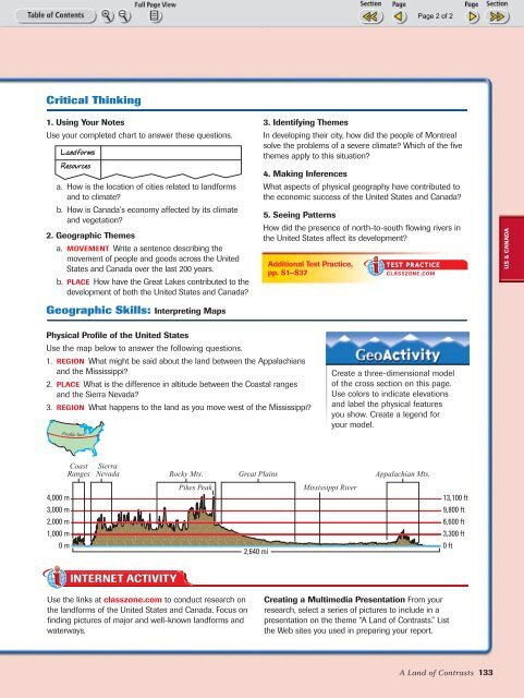
Physical Profile of the United States<br />
Use the map below to answer the following questions.<br />
1. REGION What might be said about the land between the Appalachians<br />
and the Mississippi?<br />
2. PLACE What is the difference in altitude between the Coastal ranges<br />
and the Sierra Nevada?<br />
3. REGION What happens to the land as you move west of the Mississippi?<br />
Profile<br />
line<br />
Create a three-dimensional model<br />
of the cross section on this page.<br />
Use colors to indicate elevations<br />
and label the physical features<br />
you show. Create a legend for<br />
your model.<br />
Coast<br />
Ranges<br />
Sierra<br />
Nevada<br />
Rocky Mts.<br />
Great Plains<br />
Appalachian Mts.<br />
4,000 m<br />
Pikes Peak<br />
Mississippi River<br />
13,100 ft<br />
3,000 m<br />
9,800 ft<br />
2,000 m<br />
6,600 ft<br />
1,000 m<br />
3,300 ft<br />
0 m<br />
2,640 mi<br />
0 ft<br />
Use the links at classzone.com to conduct research on<br />
the landforms of the United States and Canada. Focus on<br />
finding pictures of major and well-known landforms and<br />
waterways.<br />
Creating a Multimedia Presentation From your<br />
research, select a series of pictures to include in a<br />
presentation on the theme “A Land of Contrasts.” List<br />
the Web sites you used in preparing your report.<br />
A Land of Contrasts 133