PGS Mega Surveys - the key to new discoveries in mature areas?
PGS Mega Surveys - the key to new discoveries in mature areas?
PGS Mega Surveys - the key to new discoveries in mature areas?

You also want an ePaper? Increase the reach of your titles
YUMPU automatically turns print PDFs into web optimized ePapers that Google loves.
REPRINT<br />
A Publication of <strong>PGS</strong> Geophysical Vol. 2 No. 3<br />
August 2002<br />
<strong>PGS</strong> <strong>Mega</strong> <strong>Surveys</strong> - <strong>the</strong> <strong>key</strong> <strong>to</strong><br />
<strong>new</strong> <strong>discoveries</strong> <strong>in</strong> <strong>mature</strong> <strong>areas</strong>?<br />
<strong>PGS</strong> is now creat<strong>in</strong>g some of <strong>the</strong><br />
worlds largest ever 3D seismic data<br />
sets. Hundreds of 3D surveys from <strong>the</strong><br />
Central North Sea (CNS), <strong>the</strong> Sou<strong>the</strong>rn<br />
North Sea and West of Shetlands are<br />
now be<strong>in</strong>g merged <strong>in</strong><strong>to</strong> three separate<br />
mega surveys.<br />
The largest merge project <strong>PGS</strong> has<br />
taken on is <strong>the</strong> CNS <strong>Mega</strong> Survey,<br />
cover<strong>in</strong>g more than 60,000 sq km. For<br />
comparison, Denmark is 43,000 sqkm<br />
and <strong>the</strong> state of Louisiana 113,000 sq<br />
km. The CNS <strong>Mega</strong> Survey merges<br />
more than 150 separate 3D surveys, a<br />
task that is far from trivial. The amount<br />
of data that has <strong>to</strong> be ga<strong>the</strong>red, merged,<br />
quality controlled and <strong>in</strong>terpreted is<br />
almost <strong>in</strong>comprehensible. The first<br />
35,000 sq km is comprised of 3<br />
terabytes of migrated seismic, <strong>the</strong><br />
world's largest s<strong>in</strong>gle 3D dataset. Only<br />
a couple of years ago such a project<br />
would not have been possible due <strong>to</strong> a<br />
lack of capacity <strong>to</strong> handle <strong>the</strong> data.<br />
Cont<strong>in</strong>ued on next page<br />
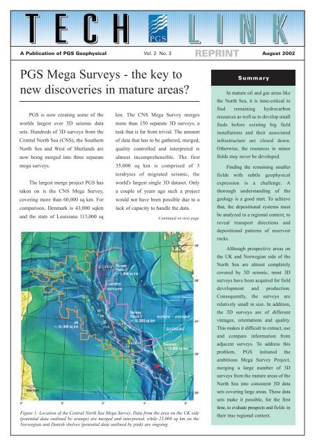
Figure 1: Location of <strong>the</strong> Central North Sea <strong>Mega</strong> Survey. Data from <strong>the</strong> area on <strong>the</strong> UK side<br />
(potential data outl<strong>in</strong>ed by orange) are merged and <strong>in</strong>terpreted, while 25,000 sq km on <strong>the</strong><br />
Norwegian and Danish shelves (potential data outl<strong>in</strong>ed by p<strong>in</strong>k) are ongo<strong>in</strong>g.<br />
Summary<br />
In <strong>mature</strong> oil and gas <strong>areas</strong> like<br />
<strong>the</strong> North Sea, it is time-critical <strong>to</strong><br />
f<strong>in</strong>d rema<strong>in</strong><strong>in</strong>g hydrocarbon<br />
resources as well as <strong>to</strong> develop small<br />
f<strong>in</strong>ds before exist<strong>in</strong>g big field<br />
<strong>in</strong>stallations and <strong>the</strong>ir associated<br />
<strong>in</strong>frastructure are closed down.<br />
O<strong>the</strong>rwise, <strong>the</strong> resources <strong>in</strong> m<strong>in</strong>or<br />
fields may never be developed.<br />
F<strong>in</strong>d<strong>in</strong>g <strong>the</strong> rema<strong>in</strong><strong>in</strong>g smaller<br />
fields with subtle geophysical<br />
expression is a challenge. A<br />
thorough understand<strong>in</strong>g of <strong>the</strong><br />
geology is a good start. To achieve<br />
that, <strong>the</strong> depositional systems must<br />
be analyzed <strong>in</strong> a regional context, <strong>to</strong><br />
reveal transport directions and<br />
depositional patterns of reservoir<br />
rocks.<br />
Although prospective <strong>areas</strong> on<br />
<strong>the</strong> UK and Norwegian side of <strong>the</strong><br />
North Sea are almost completely<br />
covered by 3D seismic, most 3D<br />
surveys have been acquired for field<br />
development and production.<br />
Consequently, <strong>the</strong> surveys are<br />
relatively small <strong>in</strong> size. In addition,<br />
<strong>the</strong> 3D surveys are of different<br />
v<strong>in</strong>tages, orientations and quality.<br />
This makes it difficult <strong>to</strong> extract, use<br />
and compare <strong>in</strong>formation from<br />
adjacent surveys. To address this<br />
problem, <strong>PGS</strong> <strong>in</strong>itiated <strong>the</strong><br />
ambitious <strong>Mega</strong> Survey Project,<br />
merg<strong>in</strong>g a large number of 3D<br />
surveys from <strong>the</strong> <strong>mature</strong> <strong>areas</strong> of <strong>the</strong><br />
North Sea <strong>in</strong><strong>to</strong> consistent 3D data<br />
sets cover<strong>in</strong>g large <strong>areas</strong>. These data<br />
sets make it possible, for <strong>the</strong> first<br />
time, <strong>to</strong> evaluate prospects and fields <strong>in</strong><br />
<strong>the</strong>ir true regional context.
TechL<strong>in</strong>k August 2002 Page 2<br />
The Central North Sea <strong>Mega</strong> Survey (CNSMS)<br />
Cont<strong>in</strong>ued from Page 1<br />
Data from <strong>the</strong> UK shelf, cover<strong>in</strong>g<br />
50,000 sq km, are already merged and<br />
<strong>in</strong>terpreted. Merg<strong>in</strong>g data from <strong>the</strong><br />
Norwegian part of <strong>the</strong> CNS (15,000 sq<br />
km) is ongo<strong>in</strong>g and data from <strong>the</strong><br />
Danish waters (10,000 sq km) are next<br />
(Figure 1).<br />
The mega surveys are based on<br />
seismic that has been released by oil<br />
companies, <strong>PGS</strong> owned seismic, and<br />
non-exclusive seismic available from<br />
o<strong>the</strong>r geophysical contrac<strong>to</strong>rs. For <strong>the</strong><br />
most part, <strong>the</strong> data are available as f<strong>in</strong>al<br />
zero-phased 3D time migrated seismic<br />
surveys. These are first QC'd and<br />
loaded <strong>to</strong> <strong>the</strong> UK PetroBank.<br />
Follow<strong>in</strong>g <strong>the</strong> <strong>in</strong>itial QC, <strong>the</strong> data are<br />
output from PetroBank, and loaded<br />
on<strong>to</strong> <strong>the</strong> <strong>PGS</strong> process<strong>in</strong>g system <strong>to</strong> start<br />
<strong>the</strong> merge process. Quality control of<br />
<strong>the</strong> merges is vital and is performed by<br />
<strong>in</strong>l<strong>in</strong>e/cross-l<strong>in</strong>e analysis of both<br />
amplitude and time data <strong>in</strong> an<br />
<strong>in</strong>teractive workstation review process.<br />
time match<strong>in</strong>g (bulk shifts);<br />
merg<strong>in</strong>g; and<br />
reload <strong>to</strong> PetroBank.<br />
After <strong>the</strong> reload, <strong>the</strong> PetroBank<br />
conta<strong>in</strong>s a common regional f<strong>in</strong>al<br />
migration 3D dataset of consistent<br />
orientation and l<strong>in</strong>e / trace number<strong>in</strong>g<br />
that can be delivered <strong>in</strong> a variety of<br />
workstation formats.<br />
Interpretation,<br />
Visualisation and Analysis<br />
At an early stage <strong>in</strong> <strong>the</strong><br />
<strong>Mega</strong>Survey project development, it<br />
was recognised that <strong>in</strong>terpret<strong>in</strong>g <strong>the</strong><br />
very large <strong>Mega</strong><strong>Surveys</strong> could stretch<br />
<strong>the</strong> resources of <strong>to</strong>day's more assetfocused<br />
oil companies. Therefore, <strong>PGS</strong><br />
also provide a complete regional<br />
<strong>in</strong>terpretation of <strong>the</strong> <strong>Mega</strong>Survey<br />
dataset, tied <strong>to</strong> released well data. This<br />
enables oil companies <strong>to</strong> concentrate on<br />
<strong>the</strong> more detailed 'search for <strong>the</strong> subtle<br />
trap' <strong>to</strong> f<strong>in</strong>d, understand, and develop<br />
rema<strong>in</strong><strong>in</strong>g reserves.<br />
An <strong>in</strong>itial feasibility study was<br />
carried out <strong>to</strong> determ<strong>in</strong>e a range of<br />
project parameters <strong>in</strong>clud<strong>in</strong>g data<br />
load<strong>in</strong>g, au<strong>to</strong> track<strong>in</strong>g, gridd<strong>in</strong>g and<br />
The different v<strong>in</strong>tages and data<br />
acquisition methods that have been<br />
used imply that <strong>the</strong> seismic varies <strong>in</strong><br />
quality. Thus, some adjustments of <strong>the</strong><br />
data are necessary <strong>to</strong> achieve <strong>the</strong><br />
optimal merge of all <strong>the</strong> different<br />
surveys. The ma<strong>in</strong> objective has been <strong>to</strong><br />
preserve <strong>the</strong> orig<strong>in</strong>al character of <strong>the</strong><br />
seismic data while ma<strong>in</strong>ta<strong>in</strong><strong>in</strong>g <strong>the</strong><br />
overall quality of <strong>the</strong> f<strong>in</strong>al product.<br />
The merge sequence consists of:<br />
<strong>in</strong>put f<strong>in</strong>al migration (SEG-Y);<br />
<strong>in</strong>terpolation, reb<strong>in</strong>n<strong>in</strong>g <strong>to</strong> standard<br />
grid;<br />
polarity check<strong>in</strong>g;<br />
phase analysis;<br />
amplitude match<strong>in</strong>g;<br />
Figure 2: Timeslice through <strong>the</strong> CNS <strong>Mega</strong><br />
Survey (35,000 sq. km) show<strong>in</strong>g <strong>the</strong> start of <strong>the</strong><br />
extensions <strong>in</strong><strong>to</strong> South Norway and Denmark.<br />
Lower left corner: example of UK well tie l<strong>in</strong>e.<br />
Al<strong>to</strong>ge<strong>the</strong>r 1600 wells are tied <strong>to</strong> <strong>the</strong> survey.
Page 3<br />
A Publication of <strong>PGS</strong> Geophysical<br />
mapp<strong>in</strong>g. This work developed both a<br />
data management and <strong>in</strong>terpretation<br />
methodology.<br />
The aim of <strong>the</strong> <strong>in</strong>terpretation of <strong>the</strong><br />
<strong>Mega</strong> <strong>Surveys</strong> is <strong>to</strong> provide a consistent<br />
regional digital <strong>in</strong>terpretation across <strong>the</strong><br />
entire area, tied <strong>to</strong> released well data<br />
(Figure 2). The <strong>in</strong>terpretation is focused<br />
on digital deliverables that will support<br />
all <strong>the</strong> lead<strong>in</strong>g workstations <strong>in</strong>clud<strong>in</strong>g<br />
Landmark, GeoQuest, SMT-K<strong>in</strong>gdom<br />
Suite, Geographics and Tigress. The<br />
<strong>in</strong>terpretation focuses on eight pr<strong>in</strong>cipal<br />
regional horizons <strong>to</strong> create a consistent<br />
stratigraphic framework.<br />
The well data have been supplied<br />
by <strong>the</strong> IHS Energy Group (IHS).<br />
Formation <strong>to</strong>ps and two-way travel<br />
times for more than 1600 wells were<br />
made available for both <strong>the</strong> UK and<br />
Norwegian sec<strong>to</strong>rs.<br />
Geological results<br />
of <strong>the</strong> <strong>Mega</strong> <strong>Surveys</strong><br />
<strong>in</strong>terpretation<br />
The <strong>PGS</strong> <strong>Mega</strong> <strong>Surveys</strong> allow<br />
visualization of <strong>the</strong> subsurface on a<br />
scale and resolution that has never been<br />
available. There is no better example<br />
than <strong>the</strong> Lower Tertiary sand<br />
distribution <strong>in</strong> <strong>the</strong> Central Graben as<br />
predicted from seismic amplitudes.<br />
When look<strong>in</strong>g at a typical <strong>in</strong>dividual<br />
3D survey of 250 sq km (Figure 3) <strong>the</strong><br />
result of such amplitude work is<br />
<strong>in</strong>conclusive. If <strong>the</strong> extraction is<br />
extended <strong>to</strong> cover a large survey of<br />
1000 sq km (Figure 4), aga<strong>in</strong> <strong>the</strong> result<br />
is <strong>in</strong>conclusive. When <strong>the</strong> same<br />
amplitude extraction is carried out over<br />
25,000 sq km (Figure 5 shows a subset<br />
of 15,000 sq km of <strong>the</strong> 25,000 sq km<br />
used for <strong>the</strong> amplitude extraction) <strong>the</strong><br />
result is amaz<strong>in</strong>g: an entire submar<strong>in</strong>e<br />
tertiary fan system is clearly outl<strong>in</strong>ed.<br />
This example highlights <strong>the</strong> need <strong>to</strong><br />
comb<strong>in</strong>e many 3D surveys <strong>to</strong><br />
comprehend <strong>the</strong> geology of an area like<br />
<strong>the</strong> Central North Sea. Similar<br />
methodology can be used <strong>to</strong> def<strong>in</strong>e<br />
Fulmar sand, Triassic pods (Figure 6)<br />
and Zechste<strong>in</strong> salt.<br />
Cont<strong>in</strong>ued on next page<br />
Figure 3: The RMS<br />
amplitude display<br />
over one UK block<br />
cover<strong>in</strong>g 250 sq km<br />
shows (orange<br />
colors) <strong>the</strong>re is a<br />
dist<strong>in</strong>ct sand unit<br />
present with<strong>in</strong> <strong>the</strong><br />
sequence.<br />
FIG. 3<br />
25 Km<br />
Figure 5: The RMS amplitude display<br />
cover<strong>in</strong>g approx. 15,000 sq km clearly<br />
shows an entire sub-mar<strong>in</strong>e tertiary fan<br />
system and details of its depositional<br />
morphology.<br />
FIG. 4<br />
Figure 4: The RMS amplitude display over<br />
four UK blocks cover<strong>in</strong>g 1000 sq km shows<br />
<strong>the</strong> sand unit is more extensive and conta<strong>in</strong>s<br />
thicker sections. Little can be <strong>in</strong>ferred as <strong>to</strong><br />
depositional direction or extent.<br />
The fan is com<strong>in</strong>g from <strong>the</strong> North West <strong>to</strong> South East flow<strong>in</strong>g round <strong>the</strong> flanks of <strong>the</strong> Forties-<br />
Montrose structural high, before term<strong>in</strong>at<strong>in</strong>g <strong>in</strong> <strong>the</strong> deepest part of <strong>the</strong> Central Graben, where<br />
its forward progress is impeded by <strong>the</strong> Joseph<strong>in</strong>e High.
TechL<strong>in</strong>k August 2002 Page 4<br />
Oil company use of <strong>Mega</strong><br />
<strong>Surveys</strong><br />
The seismic files have been loaded<br />
<strong>to</strong> a number of visualization systems<br />
<strong>in</strong>clud<strong>in</strong>g holoSeis, deskSeis and Magic<br />
Earth. The horizon files and mapp<strong>in</strong>g<br />
grids from <strong>the</strong> <strong>in</strong>terpretation have also<br />
been loaded <strong>to</strong> visualization systems<br />
such as ER-Mapper and ARK. These<br />
allow shaded relief (Figure 7) and<br />
illum<strong>in</strong>ation displays of <strong>in</strong>dividual<br />
horizons that greatly enhance <strong>the</strong><br />
standard con<strong>to</strong>ur map displays.<br />
Typical oil company use of <strong>the</strong><br />
<strong>Mega</strong> <strong>Surveys</strong> <strong>in</strong>clude:<br />
Evaluat<strong>in</strong>g complete bas<strong>in</strong>s<br />
The powerful quotes below are from some of <strong>the</strong> cus<strong>to</strong>mers of <strong>the</strong> UK <strong>Mega</strong> Survey<br />
Project and illustrate how oil companies are start<strong>in</strong>g <strong>to</strong> use <strong>the</strong>se "Ultra large 3D<br />
seismic surveys" (<strong>Mega</strong> <strong>Surveys</strong>) <strong>to</strong> create a true competitive advantage position.<br />
“The <strong>PGS</strong> Central North Sea and Sou<strong>the</strong>rn Gas Area <strong>Mega</strong> <strong>Surveys</strong> allow a step<br />
change <strong>in</strong> our understand<strong>in</strong>g of <strong>the</strong> petroleum geology of <strong>the</strong> North Sea.”<br />
“For <strong>new</strong> entrant companies, such as ourselves, <strong>the</strong> UK <strong>Mega</strong> Projects have leveled<br />
<strong>the</strong> play<strong>in</strong>g field allow<strong>in</strong>g us <strong>to</strong> compete on a more equal basis with <strong>the</strong> established<br />
companies.”<br />
“Our recent license application was made very much easier and more efficient as we<br />
were all participants <strong>in</strong> <strong>the</strong> <strong>PGS</strong> <strong>Mega</strong> Survey Project.”<br />
“The <strong>PGS</strong> <strong>Mega</strong> <strong>Surveys</strong> are likely <strong>to</strong> become <strong>in</strong>dustry de fac<strong>to</strong> standard data sets for<br />
exploration with<strong>in</strong> <strong>the</strong> UKCS.”<br />
- Re-evaluat<strong>in</strong>g held acreage<br />
- Evaluat<strong>in</strong>g open acreage<br />
- Re-evaluat<strong>in</strong>g produc<strong>in</strong>g fields<br />
- Re-evaluat<strong>in</strong>g abandoned fields<br />
- Def<strong>in</strong><strong>in</strong>g well locations<br />
- Evaluat<strong>in</strong>g regional play fairways<br />
- Evaluat<strong>in</strong>g complete bas<strong>in</strong>s<br />
model<strong>in</strong>g, potential field model<strong>in</strong>g and<br />
seismic attribute analysis. The <strong>PGS</strong><br />
<strong>Mega</strong> <strong>Surveys</strong> push current technology<br />
<strong>to</strong> <strong>the</strong> limit, but are already provid<strong>in</strong>g a<br />
basis for a <strong>new</strong> era of hydrocarbon<br />
exploration and development.<br />
The <strong>PGS</strong> <strong>Mega</strong> Survey Project also<br />
exemplifies a very successful <strong>in</strong>tegrated<br />
project between various parts of <strong>the</strong><br />
<strong>PGS</strong> organization: <strong>PGS</strong> Reservoir<br />
Consultants, Exploration Service and<br />
Data Process<strong>in</strong>g.<br />
The <strong>PGS</strong> <strong>Mega</strong> Survey Projects<br />
will likely form <strong>the</strong> basis for a number<br />
of fur<strong>the</strong>r studies that will <strong>in</strong>clude bas<strong>in</strong><br />
CONTACT<br />
<strong>PGS</strong> Geophysical<br />
London<br />
Tel: 44-1932-260001<br />
Fax: 44-1932-266465<br />
Oslo<br />
Tel: 47-67-52-6400<br />
Fax: 47-67-52-6464<br />
Hous<strong>to</strong>n<br />
Tel: 1-281-509-8000<br />
Fax: 1-281-509-8500<br />
S<strong>in</strong>gapore<br />
Tel: 65-6735-6411<br />
Fax: 65-6735-6413<br />
© 2002 Petroleum Geo-Services. All Rights Reserved<br />
Figure 6: Triassic pod identification based<br />
on <strong>Mega</strong> Survey seismic attribute analysis.<br />
For more <strong>in</strong>formation about this project, contact:<br />
Interpretation Project<br />
Huw Edwards<br />
<strong>PGS</strong> Reservoir Consultants<br />
Tel: 44-1628-641000<br />
Email: huw.edwards@pgs.com<br />
Figure 7: Relief of Base Cretaceous<br />
reflec<strong>to</strong>r; Central Graben.<br />
Seismic Data Licens<strong>in</strong>g<br />
Jerry Witney<br />
<strong>PGS</strong> Exploration<br />
Tel: 44-1932-260001<br />
Email: jerry.whitney@pgs.com<br />
For Updates on <strong>PGS</strong> Technological Advances, visit www.pgs.com<br />
More TechL<strong>in</strong>ks at www.pgs.com/techl<strong>in</strong>k