Cache Site Index - Gold Country
Cache Site Index - Gold Country
Cache Site Index - Gold Country

You also want an ePaper? Increase the reach of your titles
YUMPU automatically turns print PDFs into web optimized ePapers that Google loves.
<strong>Site</strong> #020102<br />
GC1TWXX<br />
Pioneers & Early Settlers<br />
<strong>Cache</strong> Creek Park<br />
Story of the Mysterious Mine Shaft<br />
Written & Researched by Kathy Paulos<br />
Nearest Community:<br />
Location/Parking:<br />
Geocache Location:<br />
Accuracy:<br />
Letterboxing Clues:<br />
<strong>Site</strong> Identification<br />
UTM:<br />
Geocache altitude:<br />
Overall difficulty:<br />
Terrain difficulty:<br />
<strong>Cache</strong> Creek, V0K 1H0<br />
N 50°48.942’<br />
W 121°19.554’<br />
N 50°48.982’<br />
W 121°19.643’<br />
5 meters<br />
Refer to letterboxing<br />
clues page<br />
East 0617826;<br />
North 5630738 10U<br />
463 m./1,520 ft.<br />
3<br />
1.5<br />
(1=easiest; 5=hardest)<br />
Date Established: 1901<br />
Ownership: Village of<br />
<strong>Cache</strong> Creek<br />
Access: • Public Road<br />
• Year-round<br />
• Vehicle accessible<br />
• From Hwy 97N,<br />
follow Parke Rd. to<br />
Quartz Rd. Head<br />
north on Quartz Rd.<br />
• High activity area,<br />
use stealth.<br />
For more information or to report a problem<br />
with this site please contact:<br />
<strong>Gold</strong> <strong>Country</strong> Communities Society<br />
P.O. Box 933 <strong>Cache</strong> Creek, B.C. V0K 1H0<br />
Tel: 1-877-453-9467<br />
email: info@exploregoldcountry.com<br />
For more site pages go to:<br />
www.goldtrail.com or<br />
www.GeoTourismCanada.com<br />
Apply Sticker<br />
Here<br />
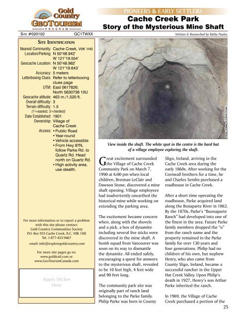
View inside the shaft. The white spot in the centre is the hard hat<br />
of a village employee exploring the shaft.<br />
Great excitement surrounded<br />
the Village of <strong>Cache</strong> Creek<br />
Community Park on March 7,<br />
1990 at 6:00 pm when local<br />
children, Brennan LeClair and<br />
Dawson Stone, discovered a mine<br />
shaft opening. Village employees<br />
had inadvertently unearthed the<br />
historical mine while working on<br />
extending the parking area.<br />
The excitement became concern<br />
when, along with the shovels<br />
and a pick, a box of dynamite<br />
including several live sticks were<br />
discovered in the mine shaft. A<br />
bomb squad from Vancouver was<br />
soon on its way to dismantle<br />
the dynamite. All ended safely,<br />
encouraging a quest for answers<br />
to the mysterious shaft, revealed<br />
to be 10 feet high, 4 feet wide<br />
and 90 feet long.<br />
The community park site was<br />
originally part of ranch land<br />
belonging to the Parke family.<br />
Philip Parke was born in County<br />
Sligo, Ireland, arriving in the<br />
<strong>Cache</strong> Creek area during the<br />
early 1860s. After working for the<br />
Cornwall brothers for a time, he<br />
and Charles Semlin purchased a<br />
roadhouse in <strong>Cache</strong> Creek.<br />
After a short time operating the<br />
roadhouse, Parke acquired land<br />
along the Bonaparte River in 1862.<br />
By the 1870s, Parke’s “Buonaparte<br />
Ranch” had developed into one of<br />
the finest in the area. Future Parke<br />
family members dropped the “u”<br />
from the ranch name and the<br />
property remained in the Parke<br />
family for over 130 years and<br />
four generations. Philip had no<br />
children of his own, but nephew<br />
Henry, who also came from<br />
County Sligo, Ireland, became a<br />
successful rancher in the Upper<br />
Hat Creek Valley. Upon Philip’s<br />
death in 1927, Henry’s son Arthur<br />
Parke inherited the ranch.<br />
In 1969, the Village of <strong>Cache</strong><br />
Creek purchased a portion of the<br />
25<br />
Photo: Village of <strong>Cache</strong> Creek