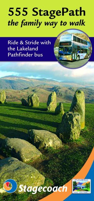
555 StagePath the family way to walk - thedms
555 StagePath the family way to walk - thedms
555 StagePath the family way to walk - thedms

You also want an ePaper? Increase the reach of your titles
YUMPU automatically turns print PDFs into web optimized ePapers that Google loves.
<strong>555</strong> <strong>StagePath</strong><br />
<strong>the</strong> <strong>family</strong> <strong>way</strong> <strong>to</strong> <strong>walk</strong><br />
Ride & Stride with<br />
<strong>the</strong> Lakeland<br />
Pathfinder bus
<strong>555</strong> <strong>StagePath</strong> <strong>the</strong> <strong>family</strong> <strong>way</strong> <strong>to</strong> <strong>walk</strong><br />
Ride & Stride with <strong>the</strong> Lakeland Pathfinder bus<br />
INTRODUCING <strong>the</strong> first <strong>walk</strong>ing route dedicated <strong>to</strong> a<br />
Lakeland bus service. Eight <strong>walk</strong> stages link <strong>the</strong><br />
regular bus s<strong>to</strong>ps for <strong>the</strong> <strong>555</strong> Stagecoach bus between<br />
Windermere and Keswick.<br />
This is perhaps <strong>the</strong> most popular bus journey in<br />
England and certainly one of <strong>the</strong> most scenic. Now you<br />
can use <strong>the</strong> bus <strong>to</strong> enjoy both <strong>the</strong> picturesque scenery and<br />
an inspirational health-giving <strong>walk</strong>. The <strong>walk</strong>ing route<br />
includes such iconic and exquisite locations as Orrest<br />
Head, Brockhole, Rydal Water, Grasmere, Dunmail Raise,<br />
Thirlmere and Castlerigg S<strong>to</strong>ne Circle – pure magic every<br />
step of <strong>the</strong> <strong>way</strong>, <strong>to</strong> enjoy with <strong>family</strong> and friends at any<br />
season of <strong>the</strong> year.<br />
The two-<strong>way</strong> route description in this booklet gives<br />
you <strong>the</strong> flexibility and freedom <strong>to</strong> <strong>walk</strong> ei<strong>the</strong>r north or<br />
south from each bus s<strong>to</strong>p. The whole <strong>walk</strong> tracks <strong>the</strong> bus<br />
largely at valley level, gaining only modest height above<br />
<strong>the</strong> road <strong>to</strong> take advantage of viewpoints. The gradients<br />
are easy and <strong>the</strong> paths firm and well-marked.<br />
Although it’s not ‘proper fell-<strong>walk</strong>ing’ it would<br />
none<strong>the</strong>less be wise <strong>to</strong> carry a light daypack with a snack<br />
and drink, and wear comfy boots. Some measure of<br />
wea<strong>the</strong>r protective clothing will come <strong>to</strong> your rescue if <strong>the</strong><br />
elements – wind, rain or intense sun – threaten <strong>to</strong> spoil<br />
your ‘off-bus adventure’.<br />
Taking <strong>the</strong> bus is relaxing – if you sit upstairs <strong>the</strong> views<br />
get even better – and if you <strong>walk</strong> one stage at a time you<br />
can have fun building up <strong>the</strong> stages <strong>to</strong> complete <strong>the</strong><br />
whole romantic 26-mile journey both on foot and by bus.<br />
The <strong>walk</strong> can also be studied in greater detail online<br />
by visiting www.markrichards.info and clicking on ‘Ride &<br />
Stride <strong>StagePath</strong>s’.<br />
Window-gazers can also reflect on <strong>the</strong> <strong>walk</strong> and<br />
mountain scenery with <strong>the</strong> aid of <strong>the</strong> <strong>555</strong>’s unique<br />
guide <strong>to</strong> <strong>the</strong> ride leaflet ‘From A <strong>to</strong> B <strong>to</strong> SEE’.<br />
<strong>555</strong> <strong>StagePath</strong><br />
STAGE 1 Windermere | Brockhole 4 1 ⁄2 miles 3 hours<br />
STAGE 2 Brockhole | Ambleside 3 miles 2 hours<br />
STAGE 3 Ambleside | Rydal 1 1 ⁄2 miles 1 hour<br />
STAGE 4 Rydal | Grasmere 2 miles 1 1 ⁄4 hours<br />
STAGE 5 Grasmere | Wythburn 4 3 ⁄4 miles 3 hours<br />
STAGE 6 Wythburn | Thirlspot 3 1 ⁄4 miles 2 hours<br />
STAGE 7 Thirlspot | Dale Bot<strong>to</strong>m 4 miles 2 hours<br />
STAGE 8 Dale Bot<strong>to</strong>m | Keswick 3 1 ⁄4 miles 2 hours<br />
ALWAYS Check <strong>the</strong> timetable - usually displayed at<br />
each bus s<strong>to</strong>p - <strong>to</strong> confirm bus times for <strong>the</strong> beginning<br />
and <strong>the</strong> end of each <strong>walk</strong> stage.<br />
You can also phone TRAVELINE 0871 200 22 33<br />
Or visit www.stagecoachbus.com for advance planning.<br />
The <strong>StagePath</strong> in <strong>the</strong> booklet has been carefully<br />
researched and described for clarity of route finding.<br />
The maps on <strong>the</strong> o<strong>the</strong>r hand are very basic. There is<br />
no substitute for carrying and referring <strong>to</strong> <strong>the</strong> correct<br />
Ordnance Survey Explorer Map. Make sure you get<br />
hold of OL7, OL5 and OL4 and/or <strong>the</strong> handy Harvey<br />
Lake District Outdoor Atlas before you start.<br />
Map Key<br />
Line - Journey of <strong>the</strong> <strong>555</strong> bus service<br />
Dashes - The route of <strong>the</strong> <strong>StagePath</strong><br />
Dots - Request and Timetabled bus s<strong>to</strong>ps
STAGE 1 NORTHBOUND<br />
A leisurely three hours up hill, down dale<br />
Windermere Station ><br />
Brockhole National Park Centre<br />
An inspiring start <strong>to</strong> your <strong>StagePath</strong> adventure climbing <strong>to</strong> <strong>the</strong><br />
<strong>to</strong>p of Orrest Head <strong>to</strong> survey <strong>the</strong> great lake with its inspiring<br />
backdrop of Lakeland Fells. A thrilling moment enjoyed by<br />
early <strong>to</strong>urists from well before <strong>the</strong> arrival of <strong>the</strong> rail<strong>way</strong>, <strong>the</strong>re<br />
could be no better stagesetter.<br />
Leave Windermere from <strong>the</strong> Rail<strong>way</strong> Station bus s<strong>to</strong>p.<br />
Walk past Booths Supermarket (go under <strong>the</strong> canopy) <strong>to</strong><br />
reach <strong>the</strong> road junction with <strong>the</strong> Gate<strong>way</strong> Tourist<br />
Information Centre <strong>to</strong> your left. Turn right, carefully cross<br />
<strong>the</strong> main A591 via <strong>the</strong> traffic island, overlooked by The<br />
Windermere Hotel. Turn left along <strong>the</strong> footpath, after 50m<br />
spot <strong>the</strong> ‘Footpath <strong>to</strong> Orrest Head’ notice on your right.<br />
Follow its pointing hand and ascend <strong>the</strong> metalled lane.<br />
Ignore <strong>the</strong> path fork and continue <strong>to</strong> follow <strong>the</strong> yellow<br />
‘Windermere Way’ <strong>way</strong>mark and ‘Orrest Head Viewpoint’<br />
white arrow. The road winds uphill passing <strong>the</strong> entrance <strong>to</strong><br />
Orrest How <strong>to</strong> enter woodland. Stay on <strong>the</strong> road. Pass a<br />
cottage selling refreshments and hand-crafted ironwork.<br />
The road becomes a track after a yew tree before <strong>the</strong><br />
woodland. At <strong>the</strong> edge of <strong>the</strong> woodland turn right at <strong>the</strong><br />
wall. Here <strong>the</strong> path becomes confined leading <strong>to</strong> a metal<br />
kissing-gate (with Heywood memorial s<strong>to</strong>ne) and you<br />
enter <strong>the</strong> Orrest Head Viewpoint enclosure.<br />
Ascend <strong>the</strong> rough steps <strong>to</strong> <strong>the</strong> bare rock summit, with<br />
seats facing in various directions <strong>to</strong> suit <strong>the</strong> appreciative<br />
audience. Sadly <strong>the</strong> <strong>to</strong>pograph – for all <strong>the</strong> legendary view<br />
– is devoid of legend! The plinth points north-west over<br />
<strong>the</strong> head of Lake Windermere <strong>to</strong> <strong>the</strong> stirring heights<br />
above Great Langdale. The panorama is amazing. Linger<br />
awhile, regain your breath and res<strong>to</strong>re your belief in our<br />
wonderful world. Note <strong>the</strong><br />
vertically-tilted and cracked bare<br />
rock beneath your feet<br />
indicating <strong>the</strong> effects<br />
of glacial smoothing.<br />
The place-name<br />
‘Orrest’ is a very rare<br />
instance of <strong>the</strong> Norse<br />
orrusta ‘battle’, meaning<br />
a meeting of armies.<br />
Brockhole<br />
Troutbeck<br />
Bridge<br />
Head north, straight on over<br />
<strong>the</strong> <strong>to</strong>p, and, taking <strong>the</strong> left-hand<br />
fork, descend <strong>to</strong> a kissing-gate and<br />
wall-stile in <strong>the</strong> enclosure corner. Cross<br />
<strong>the</strong> wall-stile signed ‘Cause<strong>way</strong>’ and<br />
go gently downhill, keeping <strong>the</strong> wall<br />
Orrest<br />
Head<br />
Windermere Station
Windermere from Orrest Head<br />
left. Cross a s<strong>to</strong>ne flag over a gill <strong>to</strong> arrive at a wall-stile<br />
on<strong>to</strong> <strong>the</strong> road. This was <strong>the</strong> original Roman <strong>way</strong> from<br />
Medibogdum (Watercrook Roman Fort, near Kendal) and<br />
Galava (<strong>the</strong> Roman fort at Ambleside). Turn right, take <strong>the</strong><br />
road <strong>to</strong> Near Orrest – was this <strong>the</strong> battleground referred <strong>to</strong><br />
in <strong>the</strong> name ‘Orrest’ ie near <strong>the</strong> battleground? Traversing<br />
<strong>the</strong> high wall-stile on <strong>the</strong> left signed ‘Far Orrest’, pass <strong>the</strong><br />
large bank-barn and after <strong>the</strong> kissing-gate cross <strong>the</strong> next<br />
paddock <strong>to</strong> a fur<strong>the</strong>r kissing-gate, and continue via a small<br />
open copse <strong>to</strong> a wall-stile. Traverse <strong>the</strong> damp pasture <strong>to</strong> a<br />
wall-stile, advancing with <strong>the</strong> wall now <strong>to</strong> <strong>the</strong> right, cross a<br />
ladder-stile <strong>the</strong>n step over a wall-side gill. Traverse <strong>the</strong> field<br />
half-right, cross a second ladder-stile and follow <strong>the</strong><br />
left-hand wall <strong>to</strong> a kissing-gate/gate close <strong>to</strong> Far Orrest.<br />
Turn right <strong>to</strong> a second kissing-gate/gate. Turn left and<br />
pass on behind <strong>the</strong> farmhouse <strong>to</strong> a third kissing-gate<br />
entering a walled green lane. Stay in <strong>the</strong> green lane <strong>to</strong> <strong>the</strong><br />
kissing-gate beside a field-gate. Do not go through <strong>the</strong><br />
obvious gate opposite. Keep <strong>the</strong> wall close left. Glance<br />
over <strong>the</strong> wall for a fine view <strong>to</strong>wards <strong>the</strong> head of<br />
Windermere; <strong>the</strong>y are hidden from view but you are<br />
directly above ‘Holehird’, <strong>the</strong> Lakeland Horticultural<br />
Society’s beautiful gardens, maintained by volunteers<br />
and open <strong>to</strong> <strong>the</strong> public. Go through a new field-gate and<br />
follow <strong>the</strong> open track across <strong>the</strong> field ahead, descending<br />
<strong>to</strong> a galvanised gate on<strong>to</strong> <strong>the</strong> road. Turn left and follow<br />
<strong>the</strong> road downhill passing <strong>the</strong> entrance <strong>to</strong> Low Longmire,<br />
Fusethwaite Yeat (which is Viking for ‘cow-house clearing,<br />
gate’) and lower down, ironically, High Longmire.<br />
Cross over <strong>the</strong> junction at <strong>the</strong> foot of <strong>the</strong> hill, turn right<br />
along <strong>the</strong> path <strong>to</strong> a bus s<strong>to</strong>p (The Kirks<strong>to</strong>ne Rambler 517<br />
summer bus service) and kissing-gate. Descend <strong>the</strong> green<br />
track in<strong>to</strong> <strong>the</strong> valley bot<strong>to</strong>m <strong>to</strong> a hand-gate and cross two<br />
foot-bridges over Trout Beck – for one brief moment you<br />
are on an island! Ascend <strong>the</strong> sunken path <strong>to</strong> <strong>the</strong> western<br />
end of Troutbeck village. Some 400m right is ‘Townend’,<br />
a beautiful vernacular yeoman farmhouse (National<br />
Trust). Ascend <strong>the</strong> facing brick-cobbled drive beside<br />
Townfoot. As it rises through a gate it becomes a confined<br />
bridle-path <strong>to</strong> <strong>the</strong> road. Turn left and, as <strong>the</strong> road swings<br />
right, go straight on down <strong>the</strong> bridle-<strong>way</strong>, Wain Lane. This<br />
rough-tracked <strong>way</strong> passes several handsome old barns,<br />
narrowing as it goes <strong>to</strong> pass <strong>the</strong> well-screened Middlerigg<br />
Tarn. Cross <strong>the</strong> main road carefully and follow <strong>the</strong><br />
cycle/foot<strong>way</strong> <strong>to</strong> <strong>the</strong> north-bound bus s<strong>to</strong>p at Brockhole<br />
(meaning ‘<strong>the</strong> badgers’ set’).
STAGE 1<br />
SOUTHBOUND<br />
Brockhole National Park Centre ><br />
Windermere Station<br />
Ascending by old lanes <strong>to</strong> catch a brief glance of Troutbeck, one<br />
of Lakeland’s most au<strong>the</strong>ntic vernacular villages. The route<br />
<strong>the</strong>n crosses Trout Beck itself, before climbing again <strong>to</strong> venture<br />
through quiet pastures and <strong>to</strong> stand on <strong>to</strong>p of Orrest Head, <strong>the</strong><br />
acknowledged classic Lakeland viewpoint. Here you can survey<br />
not just <strong>the</strong> greatest girth of Windermere but also <strong>the</strong> distant<br />
mountain heart of Lakeland – a sight <strong>to</strong> gladden <strong>the</strong> heart and<br />
feast <strong>the</strong> eyes.<br />
Carefully cross <strong>the</strong> road and <strong>walk</strong> left along <strong>the</strong><br />
cycle/footpath some 170m. Cross back over <strong>the</strong> busy<br />
road with <strong>the</strong> utmost care. Enter Wain Lane with its blue<br />
bridle-<strong>way</strong> sign (and discouragement <strong>to</strong> mo<strong>to</strong>rcycles).<br />
This walled lane leads via a barn, over a s<strong>to</strong>ne flag bridge<br />
<strong>to</strong> pass Middlerigg Tarn, gaps in <strong>the</strong> wall permitting<br />
glimpses of <strong>the</strong> shy waters and resident swans. The lane<br />
rises by several handsome old s<strong>to</strong>ne field barns before<br />
emerging on<strong>to</strong> a minor road. Go forward find a<br />
bridle<strong>way</strong> signed right as <strong>the</strong> ‘Windermere Way’. Descend<br />
<strong>the</strong> confined path via a gate and down <strong>the</strong> cobbled<br />
drive by Townfoot, a well-tended traditional farmhouse.<br />
The village of Troutbeck is a string development of<br />
traditional barns (many converted) and yeoman’s houses<br />
lining <strong>the</strong> road for a good mile <strong>to</strong> <strong>the</strong> north. Sadly all <strong>the</strong><br />
Townend pix <strong>to</strong> come . . .<br />
Westmorland bank-barn in Wain Lane<br />
places of refreshment lie at <strong>the</strong> fur<strong>the</strong>st end – two pubs<br />
and a village shop tea room. Cross straight over and<br />
down <strong>the</strong> sunken path <strong>to</strong> reach Trout Beck, a lovely spot<br />
<strong>to</strong> linger with two footbridges linking across an island.<br />
Go through <strong>the</strong> hand-gate and ascend <strong>the</strong> green <strong>way</strong> <strong>to</strong> a<br />
kissing-gate beside a bus s<strong>to</strong>p (The Kirks<strong>to</strong>ne Rambler<br />
service 517, summer only).<br />
Go right with <strong>the</strong> foot<strong>way</strong> <strong>to</strong> <strong>the</strong> road junction. Cross<br />
and <strong>walk</strong> up this road (no verges so watch for traffic). Pass<br />
up by Fusethwaite Yeat, and directly after <strong>the</strong> entrance <strong>to</strong><br />
Low Longmire find a signposted footpath ‘Far Orrest’ on<br />
<strong>the</strong> right. Go through <strong>the</strong> galvanised field-gate and follow<br />
<strong>the</strong> open track <strong>to</strong> a gate. Continue with a wall <strong>to</strong> <strong>the</strong> right<br />
and pass through a kissing-gate/field-gate in<strong>to</strong> a walled<br />
lane. Follow <strong>the</strong> lane <strong>to</strong> where a footpath crosses, go<br />
though <strong>the</strong> left-hand kissing-gate and turn right. After 60m<br />
arrive at a kissing-gate/gate on <strong>the</strong> right. After Far Orrest<br />
farmhouse, go through <strong>the</strong> immediate kissing-gate ahead.<br />
Advance with a wall on <strong>the</strong> right <strong>to</strong> cross <strong>the</strong> ladder-stile<br />
and maintain your course <strong>to</strong> a second ladder-stile, this<br />
time with a tiny gill in front. Continue <strong>to</strong> <strong>the</strong> wall-stile in<br />
<strong>the</strong> next corner and cross a damp pasture <strong>to</strong> a wall-stile<br />
in<strong>to</strong> a small spinney leading through <strong>to</strong> a kissing-gate.<br />
Advance right <strong>to</strong> Near Orrest, via a kissing-gate <strong>to</strong> <strong>the</strong> right<br />
of a muddy farmyard entrance gate. Continue passing <strong>the</strong><br />
large bank-barn <strong>to</strong> cross a tall wall-stile on<strong>to</strong> <strong>the</strong> road.<br />
Turn right for 200m <strong>to</strong> cross a wall-stile beside a<br />
field-gate on <strong>the</strong> left, signed ‘Windermere Way’. Orrest<br />
Head forms <strong>the</strong> horizon. Follow a green track and cross a<br />
s<strong>to</strong>ne flag over a gill by <strong>the</strong> wall, keeping fairly close <strong>to</strong> <strong>the</strong><br />
right-hand wall rising up <strong>to</strong> a wall-stile in <strong>the</strong> field corner.
Entering <strong>the</strong> Orrest Head enclosure follow <strong>the</strong> green path<br />
flanked by bushes and bracken <strong>to</strong> <strong>the</strong> summit. Wow –<br />
what a wonderful all-round panorama! The <strong>to</strong>pograph<br />
plinth points north-west over <strong>the</strong> head of Windermere<br />
in<strong>to</strong> <strong>the</strong> heart of mountain Lakeland. Cross straight over<br />
<strong>the</strong> bare rock <strong>to</strong>p descending <strong>the</strong> flight of steps <strong>to</strong><br />
<strong>the</strong> kissing-gate and follow <strong>the</strong> path right. Entering<br />
a woodland watch for a left turn immediately before<br />
<strong>the</strong> path steepens. This leads on<strong>to</strong> a track that smartly<br />
becomes a metalled road. Passing a cottage descend <strong>the</strong><br />
winding road <strong>to</strong> <strong>the</strong> main road. Go left along <strong>the</strong> foot<strong>way</strong><br />
50m and cross <strong>the</strong> busy road via <strong>the</strong> pedestrian refuge.<br />
Bear left in<strong>to</strong> <strong>the</strong> rail<strong>way</strong> station car park by Booths<br />
supermarket <strong>to</strong> catch your bus.<br />
The second footbridge of <strong>the</strong> two-part crossing of Trout Beck<br />
STAGE 2 NORTHBOUND<br />
Allow two hours, gently undulating<br />
Brockhole National Park Centre ><br />
Ambleside<br />
Ano<strong>the</strong>r steady climb rewarded with memorable views over <strong>the</strong><br />
upper reaches of Windermere visiting Jenkin Crag in Skelghyll<br />
Wood, which provides a wonderfully intimate view of <strong>the</strong><br />
backdrop of <strong>the</strong> lake, <strong>the</strong> beginnings of mountain Lakeland.<br />
Ambleside<br />
From <strong>the</strong> southbound bus s<strong>to</strong>p follow Mirk<br />
Lane as directed on <strong>the</strong> bus s<strong>to</strong>p post. This<br />
private metalled road leads past Merewood Lodge<br />
(holiday lets). As <strong>the</strong> road ends after Merewood<br />
Cottages bear up <strong>the</strong> narrow path flanked by an<br />
old wall, climbing as a rough lane between<br />
Newclose Wood and pasture. Stay<br />
on <strong>the</strong> lane leading down <strong>to</strong> a<br />
gate and cross <strong>the</strong> flags<strong>to</strong>nes<br />
over a stream and beside <strong>the</strong><br />
garden walls of Wood Farm.<br />
Stepping on<strong>to</strong> a road<strong>way</strong><br />
turn left, signed ‘To<br />
Troutbeck & Holbeck<br />
Lane’. Respect <strong>the</strong> privacy of<br />
Brockhole<br />
<strong>the</strong> large residence. Keep ahead,<br />
off <strong>the</strong> road and up <strong>the</strong> winding<br />
lane via a gate, still with woodland left and pasture right.<br />
Leaving <strong>the</strong> woodland at a stile/gate <strong>the</strong> walled track,<br />
hereon known as Grand Ma’s Lane, rises <strong>to</strong> Castle Syke<br />
Farm, with <strong>the</strong> barn conversion farmhouse right and<br />
bank-barn left.<br />
At <strong>the</strong> road turn left, following Holbeck Lane (minor<br />
road) with handsome views over Windermere. After<br />
Jenkin Crag, <strong>the</strong> perfect place for a <strong>family</strong> picnic
STAGE 2<br />
SOUTHBOUND<br />
Get a<strong>way</strong> from <strong>the</strong> crowds and lakeshore traffic <strong>to</strong> survey<br />
Windermere and <strong>the</strong> grand backdrop of mountain Lakeland<br />
from on high. The route having climbed <strong>to</strong> Jenkin Crag and<br />
High Skelghyll progressively descends by a series of lovely lanes<br />
<strong>to</strong> Brockhole, where you may fill your mind with <strong>the</strong> wonders of<br />
Lakeland for ano<strong>the</strong>r day.<br />
Ambleside > Brockhole National<br />
Park Centre<br />
Family <strong>walk</strong>ing in Skelghyll Lane<br />
220m bear off right along <strong>the</strong> private road signed ‘Skelgill<br />
Farms and flats only’. Shortly after Close Cottage <strong>the</strong><br />
Langdale Pikes come in<strong>to</strong> view ahead; fur<strong>the</strong>r along are<br />
grand westward views over Windermere’s Pullwood Bay,<br />
backed by Black Fell and <strong>the</strong> Conis<strong>to</strong>n Fells. From a gate<br />
<strong>the</strong> unenclosed road leads on passed an isolated<br />
bank-barn rising via a hand-gate/gate, going under Low<br />
Skelghyll <strong>the</strong>n up by a bank-barn and gate, winding <strong>to</strong><br />
cross Hol Beck kissing-gate/cattle grid.<br />
The road<strong>way</strong> passes a bridle<strong>way</strong> sign ‘Ambleside 1 1 ⁄4<br />
miles’ <strong>the</strong>n enters High Skelghyll farmyard, an active<br />
working environment. Redouble your respect for <strong>the</strong><br />
occupant’s privacy, as <strong>the</strong> right of <strong>way</strong> runs close <strong>to</strong> <strong>the</strong><br />
farmhouse. Continuing via <strong>the</strong> gated sheep pens, con<strong>to</strong>ur<br />
on <strong>the</strong> path <strong>to</strong> a gate in<strong>to</strong> open woodland with a clear<br />
view down <strong>to</strong> <strong>the</strong> Low Wood Hotel, and down <strong>the</strong> lake <strong>to</strong><br />
Gummers How and Claife Heights. The path descends<br />
easily, levelling beside a low wall. The National Trust sign<br />
by a gap gives access <strong>to</strong> Jenkin Crag, a rocky headland<br />
and a ‘must-see’. It overlooks <strong>the</strong> upper reaches of<br />
Windermere with Wray Castle and Blelham Tarn intimate<br />
features in view across <strong>the</strong> placid lake, and westward <strong>to</strong><br />
<strong>the</strong> Conis<strong>to</strong>n Fells. The track continues winding on <strong>the</strong><br />
old pitched <strong>way</strong>. Keep down left at a lateral path junction<br />
and cross a culverted bridge over Stencher Beck. Duly <strong>the</strong><br />
track draws by a laurel hedge and wall in<strong>to</strong> Skelghyll<br />
Lane. The lane becomes a walled road descending <strong>to</strong> <strong>the</strong><br />
junction with Old Lakes Road. Turn right passing<br />
between Heart of <strong>the</strong> Lakes/Organico and <strong>the</strong> Ambleside<br />
Mountain Rescue Base at Fisherbeck. Continue on down<br />
<strong>to</strong> <strong>the</strong> main Lake Road, cross and go right. Turn left<br />
along Kelsick Road by <strong>the</strong> Homes of Football Gallery <strong>to</strong><br />
arrive at <strong>the</strong> glass-canopied bus s<strong>to</strong>p.<br />
Walk up Kelsick Road, turn right by <strong>the</strong> Homes of<br />
Football gallery, bear left at <strong>the</strong> road sign ‘Old Lakes<br />
Road’. This side road rises and descends by Ambleside<br />
Backpackers and <strong>the</strong> Heart of <strong>the</strong> Lakes offices in<br />
Fisherbeck. Notice <strong>the</strong> Norwegian cabin across <strong>the</strong><br />
public car park on <strong>the</strong> far side of <strong>the</strong> main road. This was<br />
originally located in Conis<strong>to</strong>n and was used as W Hea<strong>to</strong>n<br />
Cooper’s studio (see his distinctive watercolours in <strong>the</strong><br />
Grasmere studio shop). Pass on behind <strong>the</strong> Mountain<br />
Rescue base and look for Skelghyll Lane, <strong>the</strong> branch road<br />
rising left at a white-washed house. The speed limit<br />
sign is signed ‘Jenkin’s Crag, Skelghyll and Troutbeck<br />
bridle<strong>way</strong>’.<br />
Climb steadily, keeping right at <strong>the</strong> bridle<strong>way</strong> sign<br />
‘Jenkin’s Crag and Skelghyll Woods’. Enjoy <strong>the</strong> handsome<br />
views over Ambleside Waterhead and <strong>the</strong> upper portion<br />
of Windermere. The metalled road becomes a rough lane<br />
entering Skelghyll Woods (National Trust). Keep rising by<br />
Family <strong>walk</strong>ing in Skelghyll Lane
STAGE 3 NORTHBOUND<br />
Walking time, barely half-an-hour<br />
Ambleside > Rydal<br />
A gentle wander through Rydal Park with <strong>the</strong> bonus of Rydal<br />
Hall’s lovely Old School Room Tea Shop and Rydal Mount,<br />
Wordsworth’s final home.<br />
Windermere from Jenkin Crag<br />
<strong>the</strong> wall, later a laurel hedge, <strong>the</strong>n by a low level metal<br />
sign at a path fork. The roughly cobbled path rises,<br />
crosses Stencher Beck and comes level with a wall on <strong>the</strong><br />
right. Take <strong>the</strong> opportunity <strong>to</strong> slip through <strong>the</strong> signed gap<br />
<strong>to</strong> visit <strong>the</strong> Jenkin Crag rock ledge viewpoint and revel in<br />
<strong>the</strong> gorgeous prospect over Windermere. Return via <strong>the</strong><br />
gap on<strong>to</strong> <strong>the</strong> broad path and go right, signed ‘Troutbeck<br />
via Robin Lane’. The path rises a little fur<strong>the</strong>r, passing a<br />
seat <strong>to</strong> leave <strong>the</strong> woodland at a gate.<br />
The con<strong>to</strong>uring path enters High Skelghyll farm’s<br />
gated farmyard. (Please respect <strong>the</strong> privacy of <strong>the</strong> people<br />
living here, it is still an active farm.) The ensuing open<br />
road leads past a three-<strong>way</strong> sign. Proceed along <strong>the</strong><br />
metalled road via <strong>the</strong> kissing-gate and cattle grid.<br />
Descend by <strong>the</strong> barn and beneath Low Skelghyll via a<br />
gate. Still on an open road descend <strong>the</strong> next pasture <strong>to</strong> a<br />
fur<strong>the</strong>r bank-barn, passing through a gate in<strong>to</strong> a walled<br />
lane. Follow this private road via Close Cottage and turn<br />
left at Holbeck Lane, a public road. Continue <strong>to</strong> <strong>the</strong><br />
bridle-lane branching right at Castle Syke Farm. A sign<br />
with naïve lettering indicates that this is ‘Grand Ma’s<br />
Lane’. Follow <strong>the</strong> track down between <strong>the</strong> farmhouse and<br />
large bank-barn via a gate in<strong>to</strong> <strong>the</strong> edge of woodland,<br />
hereon known as Mirk Lane – ‘<strong>the</strong> dark <strong>way</strong>’. Wind down<br />
via a fur<strong>the</strong>r gate <strong>to</strong> <strong>the</strong> metalled road<strong>way</strong> at Wood Farm,<br />
a private residence with an ornate garden. Leave <strong>the</strong> road<br />
at <strong>the</strong> green ‘Private no right of <strong>way</strong>’ notice and low set<br />
public footpath sign <strong>to</strong> bear right by <strong>the</strong> garden wall.<br />
Cross a gill via flags<strong>to</strong>nes and pass through <strong>the</strong> gate.<br />
Follow <strong>the</strong> lane beside <strong>the</strong> woodland leading down <strong>to</strong> <strong>the</strong><br />
road<strong>way</strong> at Merewood Lodge and continue <strong>to</strong> <strong>the</strong> main<br />
road at corresponding bus s<strong>to</strong>ps (with pedestrian<br />
island).<br />
Rydal<br />
Walk through <strong>the</strong> car park, along King<br />
Street and turn right up Church Street.<br />
Notice a wall-plaque recording<br />
The Office of William Wordsworth<br />
as distribu<strong>to</strong>r of stamps for<br />
Westmorland 1813–43, below<br />
Greggs on <strong>the</strong> right. Turn left<br />
along <strong>the</strong> main street rounding<br />
by The Market Hall and <strong>the</strong><br />
Post Office-cum-Tourist Office,<br />
Ambleside<br />
offering plenty of retail diversion <strong>to</strong> lure you off <strong>the</strong><br />
straight and narrow. Wander on down <strong>the</strong> street passing<br />
<strong>the</strong> tiny Bridge House (National Trust). (Built as an apple<br />
s<strong>to</strong>re for Ambleside Hall it was set on <strong>the</strong> bridge <strong>to</strong> evade<br />
land tax.) After <strong>the</strong> roundabout pass (or visit) <strong>the</strong> Armitt<br />
Museum, <strong>the</strong>n follow <strong>the</strong> left-hand roadside footpath<br />
beyond <strong>the</strong> Medical Centre. Cross <strong>to</strong> <strong>the</strong> Lodge at <strong>the</strong><br />
gated entrance <strong>to</strong> <strong>the</strong> Rydal Hall drive just after <strong>the</strong><br />
30mph limit signs and <strong>the</strong> bridge over Scandale Beck.<br />
Follow <strong>the</strong> fenced drive through parkland with handsome<br />
views ahead <strong>to</strong> <strong>the</strong> ridge-end Nab Scar and <strong>the</strong> high fells<br />
at <strong>the</strong> head of Rydal Beck valley. Go through <strong>the</strong><br />
camping site car park, cross over cascading Rydal Beck,<br />
via <strong>the</strong> Old School Room Tea Shop, behind Rydal Hall <strong>to</strong><br />
reach Rydal Lane. Turn down left by <strong>the</strong> entrance <strong>to</strong> <strong>the</strong><br />
lovely Rydal church, with its famous daffodil gardens.<br />
The bus s<strong>to</strong>p is at <strong>the</strong> foot of <strong>the</strong> hill.<br />
Rydal Park
STAGE 3<br />
Rydal > Ambleside<br />
SOUTHBOUND<br />
The ultimate stroll – giving you time <strong>to</strong> indulge in Rydal<br />
Church, Dora’s Field, Rydal Mount and <strong>the</strong> tea shop, before<br />
venturing through <strong>the</strong> gracious park and Ambleside, where<br />
ano<strong>the</strong>r pleasurable hour can be spent in <strong>the</strong> Armitt Museum<br />
before availing yourself of <strong>the</strong> many retail and refreshment<br />
outlets in this popular little Lakeland <strong>to</strong>wn.<br />
Dora’s Field daffodils<br />
after an Easter snowfall<br />
Ascend Rydal Lane. For<br />
an early diversion go<br />
left through St Mary’s<br />
churchyard for a simple<br />
stroll around Dora’s<br />
Field, abundant with<br />
daffodils in spring. Higher<br />
up <strong>the</strong> hill is Rydal<br />
Mount, one of Cumbria’s<br />
cultural treasures, dedicated<br />
<strong>to</strong> <strong>the</strong> life of William<br />
Wordsworth. The worldrenowned<br />
poet lived his<br />
final years here and was<br />
responsible for laying out<br />
<strong>the</strong> romantic gardens.<br />
It remains in <strong>the</strong> care of<br />
his descendants (entry<br />
fee/café).<br />
Ignore <strong>the</strong> first access <strong>to</strong> Rydal Hall and take <strong>the</strong> lane<br />
above, clearly <strong>way</strong>marked ‘footpath <strong>to</strong> Old School Room<br />
Tea Shop’. What more inducement do you need? Pass<br />
close behind <strong>the</strong> imposing Rydal Hall, which is now<br />
Carlisle’s Diocesan ecumenical conference centre,<br />
retreat, and youth centre.<br />
Enjoy Rydal Beck’s dancing waters, tucked in beside <strong>the</strong><br />
tea room, before heading on along <strong>the</strong> track <strong>way</strong>marked<br />
‘footpath <strong>to</strong> Ambleside’ accessed via <strong>the</strong> camp site car<br />
park. At a gate <strong>the</strong> footpath becomes a fenced lane<br />
leading <strong>to</strong> a Hall Lodge and gate on<strong>to</strong> <strong>the</strong> main road<br />
(request bus s<strong>to</strong>p). Cautiously cross <strong>the</strong> main road, go left<br />
along footpath, keeping left cross Scandale Beck <strong>to</strong> duly<br />
enter Ambleside. Pass <strong>the</strong> Health Centre (request bus s<strong>to</strong>p)<br />
<strong>to</strong> reach <strong>the</strong> roundabout by <strong>the</strong> Armitt Museum, ano<strong>the</strong>r<br />
treasure well worth investigating. Pass Bridge House (The<br />
National Trust’s smallest property) and follow <strong>the</strong> main<br />
road lined with shops. Crossing Rattle Gill go up by <strong>the</strong><br />
Post Office/Tourist Information Centre, swinging down<br />
right by The Market Hall. Turn right in<strong>to</strong> Church Street by<br />
Greggs bakery, noticing <strong>the</strong> wall plaque <strong>to</strong> William<br />
Wordsworth immediately below. Coming <strong>to</strong> <strong>the</strong> former<br />
Ambleside Conservative Club turn left along King Street <strong>to</strong><br />
reach <strong>the</strong> Kelsick Road bus s<strong>to</strong>p.<br />
STAGE 4 NORTHBOUND<br />
Allow an hour for this easy undulating stroll<br />
Rydal > Grasmere<br />
Most of this stage runs comfortably above <strong>the</strong> road providing<br />
romantic views over Rydal Water and <strong>the</strong> backing Loughrigg<br />
Fell, delightfully distanced from <strong>the</strong> traffic at lakeside and<br />
coming easily down by Tow Top and Dove Cottage <strong>to</strong> enter<br />
Grasmere along S<strong>to</strong>ck Lane.<br />
Ascend Rydal Lane from <strong>the</strong> bus s<strong>to</strong>p, passing <strong>the</strong><br />
entrances <strong>to</strong> Rydal Hall and The Mount. Climbing <strong>the</strong><br />
short concrete <strong>way</strong> turn immediately left along lane<br />
above Rydal Mount, with <strong>the</strong> bridle<strong>way</strong> sign ‘Grasmere’.<br />
Go through <strong>the</strong> gate and along <strong>the</strong> high walled lane,<br />
briefly glimpsing Wordsworth’s romantic style<br />
landscaped gardens over <strong>the</strong> left-hand wall. After a<br />
second gate <strong>the</strong> lane opens with <strong>the</strong> path winding on<br />
ahead, with lovely views through <strong>the</strong> trees <strong>to</strong> Rydal<br />
Water. The undulating path is never in doubt and leads<br />
<strong>to</strong> a gate at a wall corner. Con<strong>to</strong>uring on through an<br />
open gate<strong>way</strong> <strong>the</strong> path leads by two s<strong>to</strong>ne benches, <strong>the</strong><br />
backing s<strong>to</strong>ne of <strong>the</strong> first being <strong>the</strong> base of a coffin rest,<br />
now somewhere for you <strong>to</strong> rest your legs <strong>to</strong>o! After<br />
ano<strong>the</strong>r gate, <strong>the</strong> path now runs on close <strong>to</strong> a wall<br />
leading via a hand-gate <strong>to</strong> a path junction below Brockle<br />
Cottage. Continue on <strong>the</strong> track, <strong>the</strong>n metalled road at<br />
Dunnabeck leading by Skater’s Tarn at <strong>the</strong> junction with<br />
<strong>the</strong> bridle<strong>way</strong> from White Moss (bus s<strong>to</strong>p). Flanked by<br />
trees and bracken <strong>the</strong> road leads via How Top with <strong>the</strong><br />
lovely view of Silver How ahead, across Grasmere lake.<br />
Winding downhill <strong>the</strong> road passes by Dove Cottage and<br />
Coffin rest on old Coffin Route
STAGE 4<br />
Grasmere > Rydal<br />
SOUTHBOUND<br />
The easiest stage yet, and for many <strong>the</strong> most romantic. For all<br />
<strong>the</strong> popularity of <strong>the</strong> Wordsworth s<strong>to</strong>ry, <strong>the</strong>re is a magic in <strong>the</strong><br />
air as you <strong>walk</strong> by Dove Cottage and embark on <strong>the</strong> far-frommorbid<br />
Coffin Route. This bridle-path leads on well above <strong>the</strong><br />
busy road <strong>to</strong> give enchanting views over Rydal Water <strong>to</strong><br />
Loughrigg Fell <strong>to</strong> reach <strong>to</strong> Rydal Mount, an experience <strong>to</strong> be<br />
enjoyed at any season.<br />
<strong>the</strong> Wordsworth Trust’s contemporary visi<strong>to</strong>r centre in<br />
Grasmere Town End (tea rooms close by). Cautiously<br />
cross <strong>the</strong> main road. From <strong>the</strong> roundabout turn in<strong>to</strong><br />
S<strong>to</strong>ck Lane. The footpath leads in<strong>to</strong> Grasmere. Follow on<br />
Grasmere<br />
Sarah Nelson’s Grasmere Gingerbread Shop<br />
White<br />
Moss<br />
round by <strong>the</strong> church and Sarah Nelson’s<br />
Gingerbread Shop, branch right along<br />
College Street <strong>to</strong> <strong>the</strong> crossroads by<br />
Sam Read Bookseller. (The<br />
northbound bus s<strong>to</strong>p<br />
is facing and <strong>the</strong><br />
Rydal<br />
southbound <strong>to</strong> <strong>the</strong> left,<br />
opposite <strong>the</strong> Hea<strong>to</strong>n<br />
Cooper Studio.)<br />
Walkers soak up <strong>the</strong> view from How Top<br />
From <strong>the</strong> crossroads by Sam Read’s book emporium,<br />
<strong>walk</strong> south along College Street, passing Sarah Nelson’s<br />
little shop, source of a much-loved gingerbread. William<br />
and Dorothy Wordsworth’s grave can be seen in<br />
St Oswald’s Churchyard. Continue along <strong>the</strong> footpath<br />
beside S<strong>to</strong>ck Lane leading <strong>to</strong> <strong>the</strong> main road roundabout.<br />
Keep <strong>to</strong> <strong>the</strong> right and immediately cross <strong>the</strong> main road<br />
in<strong>to</strong> Town End, passing <strong>the</strong> Wordsworth Trust’s smart<br />
contemporary visi<strong>to</strong>r centre. The road leads via Dove<br />
Cottage and ascends <strong>the</strong> hill <strong>to</strong> How Top. Keep left,<br />
climbing with <strong>the</strong> road by Skater’s Tarn. Continue along<br />
<strong>the</strong> level road, which becomes a gravel lane after<br />
Dunnabeck <strong>the</strong>n leads on <strong>to</strong> Brockle Cottage. After a<br />
hand-gate <strong>the</strong> bridle<strong>way</strong> continues as a wall-side path,<br />
effectively con<strong>to</strong>uring along <strong>the</strong> hillside. Never in doubt,<br />
<strong>the</strong> path leads through a gate <strong>to</strong> reveal two s<strong>to</strong>ne seats.<br />
The block of s<strong>to</strong>ne at <strong>the</strong> back of <strong>the</strong> second was<br />
originally <strong>the</strong> basis of a coffin rest. You might wish <strong>to</strong> rest<br />
your bones here temporarily <strong>to</strong> enjoy <strong>the</strong> lovely view over<br />
Rydal Water! The level path leads via a fur<strong>the</strong>r gate,<br />
rising by fallen trees <strong>to</strong> a gate in<strong>to</strong> a lane. Glance over <strong>the</strong><br />
tall wall <strong>to</strong> glimpse Rydal Mount’s beautiful landscaped<br />
Skater’s Tarn
STAGE 5 NORTHBOUND<br />
Three hours of comparatively wilder country <strong>walk</strong>ing<br />
Grasmere > Wythburn<br />
Quiet back road <strong>to</strong> <strong>the</strong> entrance of Ghyll Foot. After <strong>the</strong><br />
entrance <strong>to</strong> Greenburn Dale you are almost fell-<strong>walk</strong>ing on <strong>the</strong><br />
climb over <strong>the</strong> shoulder of Steel Fell <strong>to</strong> reach <strong>the</strong> <strong>to</strong>p of<br />
Dunmail Raise. An easy descent via <strong>the</strong> cascading Birkside Gill<br />
gains entry on<strong>to</strong> a fine forest track running on well above <strong>the</strong><br />
road with marvellous views over Thirlmere.<br />
Wordsworth Trust Visi<strong>to</strong>r Centre<br />
garden just before passing through ano<strong>the</strong>r gate.<br />
Continue by <strong>the</strong> back wall of The Mount and bear right<br />
down <strong>the</strong> concrete road<strong>way</strong> beside <strong>the</strong> Rydal Mount car<br />
park. This is a prime opportunity <strong>to</strong> visit this famous<br />
house (café) and traditional ornate garden, or, <strong>to</strong> visit<br />
<strong>the</strong> Old School House Tea Room, go left along <strong>the</strong> lane<br />
behind Rydal Hall. O<strong>the</strong>rwise descend Rydal Lane<br />
straight <strong>to</strong> <strong>the</strong> bus s<strong>to</strong>ps at <strong>the</strong> foot of <strong>the</strong> hill.<br />
Helm Crag from Grasmere Townend<br />
From Sam Read’s bookshop <strong>walk</strong> Wythburn<br />
north along Easedale Road<br />
Church<br />
passing <strong>the</strong> entrance <strong>to</strong> Butharlyp<br />
Howe Youth Hostel and<br />
Glenthorne Quaker Guest House. Armboth<br />
road-end<br />
Slip through <strong>the</strong> hand-gate left,<br />
follow <strong>the</strong> fenced footpath<br />
adjacent <strong>to</strong> <strong>the</strong> roadside hedge<br />
and emerge at a fur<strong>the</strong>r hand-gate cross<br />
Goody Bridge. Turn right at <strong>the</strong> next<br />
road junction (brown sign Thorney How<br />
YH 400yds). Follow this quiet byroad,<br />
a real contrast with <strong>the</strong> A591 heading<br />
north over Dunmail Raise across <strong>the</strong><br />
valley. Thankfully it makes little impact<br />
here. Pass <strong>the</strong> active farmyard of<br />
Underhelm and <strong>the</strong>n descend <strong>to</strong>wards<br />
Low Mill Bridge. Go left immediately<br />
prior <strong>to</strong> <strong>the</strong> bridge at <strong>the</strong> road junction,<br />
advancing by Ghyllfoot cottages <strong>to</strong> where<br />
a private drive meets <strong>the</strong> road.<br />
Bear up this gravel track beside tree-screened<br />
Helmside, <strong>the</strong>n via two cattle grid hand-gates.<br />
Pass by two cottages at Turn Howe (date plaque<br />
1577) <strong>to</strong> reach <strong>the</strong> fell-gate, at this point<br />
entering Greenburn Dale (National Trust<br />
sign). Ignoring <strong>the</strong> inviting green track<br />
Dunmail<br />
Raise<br />
Grasmere<br />
leading in<strong>to</strong> <strong>the</strong> wild dale beside <strong>the</strong> wall, veer right up <strong>the</strong><br />
grass path, <strong>the</strong> start of <strong>the</strong> south ridge of Steel Fell.<br />
Family <strong>walk</strong>ing along <strong>the</strong> lane from Ghyllfoot
Helm Crag from Easedale Road<br />
The <strong>StagePath</strong> has no such overarching ambition, but for<br />
<strong>walk</strong>ers with a head for heights <strong>the</strong> full ascent and summit<br />
ridge traverse may be undertaken, crossing by Dead Pike and<br />
descending <strong>the</strong> corresponding steep grassy north ridge <strong>to</strong> Steel End<br />
Farm <strong>to</strong> reach <strong>the</strong> Armboth road-end bus s<strong>to</strong>p.<br />
<strong>StagePath</strong>s are tailored for country <strong>walk</strong>ers not<br />
mountain trekkers but none<strong>the</strong>less, it is necessary <strong>to</strong><br />
follow <strong>the</strong> path, beating back <strong>the</strong> bracken, up through<br />
<strong>the</strong> fell enclosures <strong>to</strong> reach a kissing-gate/gate in <strong>the</strong><br />
intake wall. Climb on, only a matter of sixty strides, <strong>to</strong> a<br />
pace or two short of a clump of rushes. Find a sheep path<br />
branching right, through bracken; this comes alongside<br />
<strong>the</strong> <strong>to</strong>p of <strong>the</strong> intake wall and con<strong>to</strong>urs beyond where<br />
this wall swings downhill. The sheep path duly eases<br />
downhill and, coming close <strong>to</strong> an obvious pile of rocks,<br />
veers downhill more purposefully over Cotra, a marshy<br />
hollow, thankfully not <strong>to</strong>o soft. Upon joining a green<br />
trac<strong>to</strong>r track, turn left after skirting glacial moraine, <strong>to</strong><br />
cross a minor ford. Bear down right along <strong>the</strong> minor<br />
track <strong>to</strong> ford Raise Beck. Continue left with <strong>the</strong> wet track<br />
<strong>to</strong> reach a gate in <strong>the</strong> fence, and <strong>the</strong>reby arrive beside <strong>the</strong><br />
roadside barrier. Turn right and carefully cross <strong>to</strong> <strong>the</strong><br />
lay-by (and request bus s<strong>to</strong>ps).<br />
Nearby is <strong>the</strong> Achille Ratti Climbing Club hut, and a<br />
rare 1950s AA call box (now a Grade II listed building).<br />
But mo<strong>to</strong>rists have no need <strong>to</strong> feel stranded – <strong>the</strong>re is<br />
al<strong>way</strong>s <strong>the</strong> <strong>555</strong>! Crossing <strong>the</strong> light fence-stile go left,<br />
parallel <strong>to</strong> <strong>the</strong> road fence coming level with <strong>the</strong> ancient<br />
Dunmail Raise cairn, traditionally associated with<br />
Dunmail, <strong>the</strong> last king of Cumberland. Go through <strong>the</strong><br />
Wythburn Dale and Armboth road-end from <strong>the</strong> forest track<br />
Helm Crag from Dunmail Raise<br />
Family <strong>walk</strong>ing along <strong>the</strong> forest track above Wythburn Church
Birkside Gill from <strong>the</strong> Thirlmere forest track<br />
hand-gate in <strong>the</strong> wall; bear half-right <strong>to</strong> cross <strong>the</strong><br />
footbridge over Raise Beck, re-aligned <strong>to</strong> boost water<br />
catchment in<strong>to</strong> Thirlmere. Turn left at <strong>the</strong> wall corner<br />
with <strong>the</strong> permitted footpath sign; follow <strong>the</strong> clear path<br />
running on north, parallel <strong>to</strong> and above <strong>the</strong> enclosure<br />
wall. Continue up, under <strong>the</strong> small plantation, <strong>to</strong> cross<br />
<strong>the</strong> two footbridges spanning <strong>the</strong> foot of Birkside Gill.<br />
The gill is renown for its marvellous waterfalls. It is<br />
tempting <strong>to</strong> de<strong>to</strong>ur up <strong>the</strong> fellside <strong>to</strong> have a look. Proceed<br />
<strong>to</strong> <strong>the</strong> forestry track via a hand-gate. A left turn leads<br />
down <strong>to</strong> <strong>the</strong> southbound bus s<strong>to</strong>p at <strong>the</strong> Armboth<br />
road-end. The northbound bus s<strong>to</strong>p is reached by<br />
following <strong>the</strong> forestry track ahead, with numerous<br />
delightful elevated views over <strong>the</strong> upper reaches of<br />
Thirlmere. The path from Wythburn Church crosses <strong>the</strong><br />
track at a gate. Descend left via <strong>the</strong> cobbled <strong>way</strong> entering<br />
<strong>the</strong> car park behind <strong>the</strong> church by hand-gate. Follow <strong>the</strong><br />
access road<strong>way</strong> left <strong>to</strong> <strong>the</strong> Grasmere-bound bus s<strong>to</strong>p.<br />
Family <strong>walk</strong>ing along <strong>the</strong> field-edge path beside Easedale Road<br />
STAGE 5<br />
SOUTHBOUND<br />
Wythburn > Grasmere<br />
From forest track <strong>to</strong> open fell with a smidgen of adventure in<br />
climbing over <strong>the</strong> shoulder of Steel Fell. The stage concludes<br />
along a quiet back road beneath Helm Crag. There are request<br />
bus s<strong>to</strong>ps at <strong>the</strong> sou<strong>the</strong>rn end of Dunmail Raise, enabling you<br />
<strong>to</strong> break this stage in two.<br />
From Wythburn Church (southbound bus): follow <strong>the</strong><br />
access road<strong>way</strong> in<strong>to</strong> <strong>the</strong> car park behind <strong>the</strong> church. Pass<br />
through <strong>the</strong> kissing-gate and ascend <strong>the</strong> pitched path <strong>to</strong><br />
reach <strong>the</strong> forest track at a kissing-gate. Turn right along<br />
<strong>the</strong> forest track <strong>to</strong> reach a big blue signboard. From <strong>the</strong><br />
Armboth road-end (northbound bus): carefully cross <strong>the</strong><br />
A592 and follow <strong>the</strong> facing forestry track rising south.<br />
This curves left <strong>to</strong> reach <strong>the</strong> big blue signboard.<br />
Turn right as directed for ‘Grasmere’. Go through <strong>the</strong><br />
kissing-gate, cross successive footbridges over <strong>the</strong> excited<br />
waters of Birkside Gill. Above is a majestic sequence of<br />
cascades, well worth a closer look. The path continues on<br />
a gently rising line close <strong>to</strong> <strong>the</strong> intake wall with Helm Crag<br />
visible over <strong>the</strong> road pass ahead. At <strong>the</strong> wall-end turn<br />
right crossing <strong>the</strong> broad footbridge and observe <strong>the</strong><br />
beck’s unnatural structure: Raise Beck was redirected<br />
when Thirlmere was constructed. Bear half-right <strong>to</strong> <strong>the</strong><br />
kissing-gate at <strong>the</strong> right-hand wall-end close <strong>to</strong> <strong>the</strong> road<br />
and <strong>the</strong> massive Dunmail Raise cairn. Continue beside<br />
<strong>the</strong> roadside fence crossing <strong>the</strong> original course of Raise<br />
Beck, now a dry s<strong>to</strong>ny bed. Ignore <strong>the</strong> ladder stile,<br />
advance <strong>to</strong> a light fence stile beside a gate and cross <strong>to</strong><br />
<strong>the</strong> large roadside lay-by, just short of <strong>the</strong> climbing club<br />
hut and <strong>the</strong> his<strong>to</strong>ric AA kiosk, now a Grade ll listed<br />
building (request bus s<strong>to</strong>ps ei<strong>the</strong>r side of <strong>the</strong> road). Cross<br />
<strong>the</strong> wide road <strong>to</strong> <strong>the</strong> barrier: be alert. Turn right <strong>to</strong> find a<br />
short track leading left down <strong>to</strong> a gate in <strong>the</strong> fence.<br />
Witnessing two <strong>555</strong> buses crossing Dunmail Raise
STAGE 6 NORTHBOUND<br />
Allow two hours<br />
Wythburn > Thirlspot<br />
Thirlmere’s surroundings have been radically improved over <strong>the</strong><br />
last year with strategic tree felling res<strong>to</strong>ring <strong>the</strong> intrinsic wild<br />
mountain demeanour of <strong>the</strong> valley. Centre-stage, <strong>the</strong> formerly<br />
sombre mere has become less <strong>the</strong> reservoir, more a Lakeland<br />
lake. The <strong>StagePath</strong> leads on as forest track, forest trail and<br />
firm fellside path.<br />
Dunmail Raise from <strong>the</strong> intake wall leading<br />
off <strong>the</strong> south ridge of Steel Fell<br />
From <strong>the</strong> gate follow <strong>the</strong> green track leading left,<br />
latterly following a stream and cross a ford in <strong>the</strong><br />
sou<strong>the</strong>rly-flowing Raise Beck. The track continues rising <strong>to</strong><br />
a track junction at a smaller ford. Follow <strong>the</strong> green track<br />
left rising round glacial moraine on<strong>to</strong> a low ridge on<br />
Cotra. Skirting a shallow marshy hollow bear off right<br />
over undulating ground <strong>to</strong> ascend <strong>the</strong> bracken bank with<br />
evidence of a sheep path. This climbs easily up <strong>the</strong> fellside<br />
slanting leftwards. Con<strong>to</strong>ur above <strong>the</strong> intake wall, soon <strong>to</strong><br />
unite with a grass path on <strong>the</strong> south ridge of Steel Fell.<br />
Turn left, descending through <strong>the</strong> kissing-gate/gate<br />
passing down <strong>the</strong> ridge via gate<strong>way</strong>s with Greenburn Dale<br />
<strong>to</strong> <strong>the</strong> right and Helm Crag ahead. Note <strong>the</strong> ‘Lion and <strong>the</strong><br />
Lamb’ rocks prominent on <strong>the</strong> skyline. At <strong>the</strong> foot of <strong>the</strong><br />
ridge join <strong>the</strong> Green Burn valley track beside a wall, go<br />
through <strong>the</strong> fell-gate (National Trust ‘Green Burn’ sign)<br />
and descend <strong>the</strong> gravel lane from Turne Howe, <strong>the</strong><br />
white-washed cottage. Proceed via two hand-gates beside<br />
cattle-grids adjacent <strong>to</strong> Helmside. At <strong>the</strong> road at <strong>the</strong> foot<br />
of <strong>the</strong> slope, turn right and follow <strong>the</strong> valley road past<br />
Ghyll Foot Cottages. Notice <strong>the</strong> pollarded willows in <strong>the</strong><br />
pasture <strong>to</strong> <strong>the</strong> right. Traditionally branches were cut not<br />
only <strong>to</strong> create sheep hurdles (see fence) but also as a<br />
source of minerals for sheep, extracted by chewing <strong>the</strong><br />
bark. At <strong>the</strong> next road junction, adjacent <strong>to</strong> Low Mill<br />
Bridge, turn right gently rising by Helmside Farm <strong>the</strong>n past<br />
several cottages near Thorney How Youth Hostel <strong>to</strong> a road<br />
junction. Turn left crossing Goody Bridge and go<br />
immediately through <strong>the</strong> hand-gate, along <strong>the</strong> fenced<br />
footpath beside <strong>the</strong> roadside hedge. At <strong>the</strong> far end a<br />
hand-gate opens on<strong>to</strong> Easedale Road. Pass on by<br />
Glenthorne, guest house, and <strong>the</strong> entrance <strong>to</strong> Butharlyp<br />
Howe Youth Hostel <strong>to</strong> <strong>the</strong> crossroads in Grasmere<br />
(northbound bus s<strong>to</strong>p immediately left, southbound bus<br />
s<strong>to</strong>p right opposite <strong>the</strong> Hea<strong>to</strong>n Cooper Studio).<br />
From Armboth road-end<br />
Thirlspot<br />
(northbound bus): follow <strong>the</strong><br />
forest track leading south directly<br />
opposite <strong>the</strong> bus s<strong>to</strong>p. This links<br />
up with <strong>the</strong> path from Dunmail The Swirls<br />
Raise, with <strong>the</strong> blue signboard<br />
directing <strong>to</strong> ‘Swirls’.<br />
From Wythburn Church (southbound<br />
bus): follow <strong>the</strong> access track-<strong>way</strong> leading<br />
<strong>to</strong> <strong>the</strong> car park behind <strong>the</strong> church and<br />
pass on via <strong>the</strong> hand-gate up <strong>the</strong> cobbled<br />
bridle-path in <strong>the</strong> forest <strong>to</strong> meet <strong>the</strong> forest<br />
track (see text above).<br />
Turn left accompanying <strong>the</strong> newly<br />
surfaced track, quickly crossing Comb and<br />
Whelpside Gills <strong>to</strong> <strong>the</strong> double<br />
footbridge crossings of Mines Gill<br />
(Whelpside refers <strong>to</strong> <strong>the</strong> his<strong>to</strong>ric ‘high<br />
breeding ground of wolves’). From <strong>the</strong><br />
ensuing kissing-gate <strong>the</strong> bridle<strong>way</strong><br />
becomes a cobbled forest path that<br />
winds slowly through <strong>the</strong> tangle of<br />
conifers. Ultimately <strong>the</strong> path comes<br />
<strong>StagePath</strong> crossing Mines Gill<br />
Wythburn<br />
Church<br />
Armboth<br />
Road-end
down via a man-made rock step on<strong>to</strong> a forest track,<br />
signed ‘Thirlmere, Swirls’. Head on north up this track,<br />
duly descending in<strong>to</strong> The Swirl car park via a kissing-gate<br />
(request bus s<strong>to</strong>ps left). Go through <strong>the</strong> car park and<br />
cross <strong>the</strong> footbridge signed ‘Helvellyn, Stanah, Sticks’.<br />
Continue following <strong>the</strong> ‘Helvellyn’ sign <strong>to</strong> a kissing-gate<br />
in a wall. Rising a few yards <strong>to</strong> a fork follow <strong>the</strong> ‘public<br />
footpath Sticks Pass, Stanah’ sign. The man-made path<br />
gently angles up <strong>the</strong> rough fellside, with retaining s<strong>to</strong>nes<br />
giving a firm footing. Cross a small footbridge and come<br />
alongside an intake wall. Where this dips down con<strong>to</strong>ur<br />
on with <strong>the</strong> new path enjoying handsome views <strong>to</strong>wards<br />
<strong>the</strong> tree-shrouded Great How, and in <strong>the</strong> distance an<br />
impressive view of Blencathra through St John’s in <strong>the</strong><br />
Vale. Coming <strong>to</strong> a wall encounter a path junction and<br />
bear down left, signed ‘Thirlspot Farm’. The sloping<br />
pitched path leads <strong>to</strong> a gate and <strong>the</strong>n a gated crossing of<br />
<strong>the</strong> Thirlmere leat, ga<strong>the</strong>ring <strong>the</strong> waters of a string of<br />
streams north from Castle Rock that would o<strong>the</strong>rwise<br />
have missed <strong>the</strong> reservoir catchment. Head down <strong>to</strong> a<br />
gate and gill, crossing left of <strong>the</strong> static caravans <strong>to</strong> pass<br />
through <strong>the</strong> farmyard by gates. Bear right <strong>to</strong> a hand-gate<br />
beside <strong>the</strong> farmhouse and continue along in front of <strong>the</strong><br />
King’s Head Hotel <strong>to</strong> reach <strong>the</strong> corresponding bus s<strong>to</strong>ps.<br />
Free-running path along <strong>the</strong> fellside above<br />
Thirlspot, looking north <strong>to</strong> Great How and<br />
through St John’s in <strong>the</strong> Vale <strong>to</strong> Blencathra<br />
STAGE 6<br />
SOUTHBOUND<br />
Thirlspot > Wythburn<br />
Beginning as a fellside path entering <strong>the</strong> forest running along<br />
<strong>the</strong> western flanks of Helvellyn <strong>to</strong> admire Thirlmere from an<br />
elevated trail. Judicious tree felling has enhanced <strong>the</strong> reservoir’s<br />
surroundings res<strong>to</strong>ring its wild mountain heart, from both road<br />
level and ‘on high’. As a fur<strong>the</strong>r bonus this is a national<br />
sanctuary for our native red squirrel. These delightful creatures<br />
are actively protected from <strong>the</strong> unwelcome advances of <strong>the</strong><br />
American grey squirrel, carriers of <strong>the</strong> squirrel parapoxvirus<br />
that destroys populations of reds.<br />
From <strong>the</strong> bus s<strong>to</strong>ps immediately north of <strong>the</strong> Thirlspot<br />
<strong>walk</strong> back <strong>to</strong> The King’s Head Hotel and pass <strong>the</strong> entrance<br />
<strong>to</strong> a hand-gate with a bridle<strong>way</strong> sign. Enter <strong>the</strong> gated lane<br />
leading through Thirlspot Farm. Cross <strong>the</strong> gated gill<br />
beside a trio of static caravans and ascend <strong>the</strong> pasture <strong>to</strong><br />
a gated crossing of <strong>the</strong> Thirlmere Leat, carrying water<br />
seemingly up-dale <strong>to</strong> join Helvellyn Gill and thus enter <strong>the</strong><br />
reservoir. Continue up <strong>to</strong> a gate in <strong>the</strong> intake wall, joining<br />
a pitched path climbing <strong>to</strong> a path junction at <strong>the</strong> <strong>to</strong>p of<br />
<strong>the</strong> adjacent rising wall. Turn right, signed ‘Swirls Car<br />
Park’, <strong>to</strong> follow <strong>the</strong> s<strong>to</strong>ne-edged con<strong>to</strong>uring path, which<br />
<strong>the</strong>n comes alongside an intake wall with consistently<br />
handsome views, particularly north <strong>to</strong>wards Skiddaw and<br />
Blencathra. The wall dips a<strong>way</strong> but <strong>the</strong> path continues<br />
con<strong>to</strong>uring and crosses a small footbridge before<br />
descending <strong>to</strong> a sign where <strong>the</strong> popular path <strong>to</strong><br />
Helvellyn branches left. From here go right, down through<br />
a kissing-gate and subsequent hand-gate. Crossing a<br />
footbridge over Helvellyn Gill enter The Swirls car park.<br />
<strong>StagePath</strong> joining <strong>the</strong> forest track <strong>to</strong> The Swirls
STAGE 7 NORTHBOUND<br />
One brief climb, o<strong>the</strong>rwise largely level going,<br />
allow two hours<br />
Thirlspot > Dale Bot<strong>to</strong>m<br />
The <strong>StagePath</strong> starts by climbing back above <strong>the</strong> intake wall <strong>to</strong><br />
visit <strong>the</strong> wild waters of Fisherplace Gill, before descending with<br />
<strong>the</strong> Sticks Pass bridle<strong>way</strong> <strong>to</strong> cross St John’s Beck and <strong>the</strong>n<br />
wandering on firm tracks by Shoulthwaite Moss and <strong>the</strong> old<br />
road under High Rigg.<br />
Approaching Thirlspot upon <strong>the</strong> high intake wall path<br />
Pass through <strong>the</strong> car park taking <strong>the</strong> first kissing-gate left,<br />
with a big blue signboard ‘permissive path <strong>to</strong> Wythburn’.<br />
Joining <strong>the</strong> forest track enter <strong>the</strong> woodland on a rising<br />
line that later descends <strong>to</strong> a broad gate. Go left on<strong>to</strong> <strong>the</strong><br />
bridle-path. Initially level, it rises and weaves through <strong>the</strong><br />
mature conifers with a firm cobbled base and steps<br />
and one small footbridge. After a kissing-gate, cross<br />
successive footbridges spanning Mines Gill and join <strong>the</strong><br />
forest track – a welcome chance <strong>to</strong> res<strong>to</strong>re a comfortable<br />
stride. Continue <strong>to</strong> Whelpside Gill and immediately after<br />
crossing <strong>the</strong> gill take <strong>the</strong> bridle-path that crosses <strong>the</strong><br />
track. For <strong>the</strong> southbound bus turn down right <strong>to</strong><br />
Wythburn Church and follow <strong>the</strong> access road<strong>way</strong> left <strong>to</strong><br />
<strong>the</strong> bus s<strong>to</strong>p. For <strong>the</strong> northbound bus s<strong>to</strong>p, continue with<br />
<strong>the</strong> forest track and as <strong>the</strong> forestry ends swing down right<br />
<strong>to</strong> reach <strong>the</strong> Armboth road-end bus s<strong>to</strong>p.<br />
The crags of Ullscarf and Thirlmere from <strong>the</strong> forest track<br />
Pass <strong>the</strong> entrance of King’s Head Hotel and go through a<br />
hand-gate with bridle<strong>way</strong> sign at <strong>the</strong> end of <strong>the</strong> building<br />
<strong>to</strong> enter Thirlspot Farm’s gated farmyard (somewhat<br />
cryptic – ‘thirlspot’ means ‘<strong>the</strong> giant’s hole’). Exit through<br />
<strong>the</strong> gate <strong>to</strong> <strong>the</strong> right of <strong>the</strong> three static caravans,<br />
ascending <strong>the</strong> pasture <strong>to</strong> a gate and cross Thirlmere Leat.<br />
A short rough s<strong>to</strong>ny pasture leads <strong>to</strong> a gate in <strong>the</strong> intake<br />
wall. Climb <strong>the</strong> pitched path <strong>to</strong> a path junction where <strong>the</strong><br />
wall levels. Turn left on a footpath signed ‘Stanah, Sticks<br />
Pass’. Follow <strong>the</strong> clear path above <strong>the</strong> wall duly dipping<br />
<strong>to</strong> cross a gated footbridge over Fisherplace Beck. There<br />
are two massive waterfalls above and it’s well worth<br />
climbing up for a closer view of <strong>the</strong> action. Con<strong>to</strong>ur<br />
forward as directed by <strong>the</strong> <strong>way</strong>mark soon coming<br />
alongside <strong>the</strong> intake wall. The path descends lining up<br />
with <strong>the</strong> Sticks Pass bridle-path at a signpost. Do not go<br />
through <strong>the</strong> hand-gate directly below; instead keep right<br />
by <strong>the</strong> wall <strong>to</strong> cross Stanah Gill by an old bridge. Bear left<br />
down <strong>to</strong> a stile/gate over <strong>the</strong> Thirlmere Leat (At this point<br />
<strong>the</strong> leat had <strong>to</strong> be bored through a massive bedrock<br />
bluff.) Descend <strong>the</strong> pasture and cross <strong>the</strong> ladder-stile<br />
on<strong>to</strong> <strong>the</strong> farm lane leading down by Thirlmere<br />
Community Hall and<br />
adjacent car park.<br />
From <strong>the</strong> cottages<br />
turn right, along<br />
<strong>the</strong> road, and pass<br />
<strong>the</strong> redundant timber<br />
building, originally a youth<br />
hostel. After some 250m<br />
find a footpath signposted<br />
from a hand-gate, enter <strong>the</strong><br />
valley pasture and follow <strong>the</strong><br />
Dale<br />
Bot<strong>to</strong>m<br />
left-hand wall <strong>to</strong>wards <strong>the</strong> main<br />
road. Cross <strong>the</strong> wall-stile and climb <strong>the</strong><br />
steps up <strong>the</strong> embankment. Turn right and<br />
follow <strong>the</strong> verge, past a request bus s<strong>to</strong>p, and<br />
<strong>the</strong>n carefully cross <strong>the</strong> main road. Turn left<br />
with <strong>the</strong> signed ‘Public road round <strong>the</strong> lake’<br />
leading past a caravan park at<br />
Bridge End Farm. Immediately after<br />
<strong>the</strong> <strong>to</strong>ilet block on <strong>the</strong> left, go<br />
Shoulthwaite<br />
Thirlspot
through <strong>the</strong> double<br />
gates right in<strong>to</strong> <strong>the</strong><br />
farmyard, following<br />
a footpath signed<br />
‘Smaithwaite’. Keep<br />
<strong>to</strong> <strong>the</strong> track by <strong>the</strong><br />
large barns, bearing<br />
down right <strong>to</strong><br />
a hand-gate. Now<br />
with a wall on your<br />
left descend <strong>to</strong> cross<br />
St John’s Beck, <strong>the</strong><br />
outflow of Thirlmere<br />
Reservoir, over a<br />
sequence of three<br />
footbridges. Notice<br />
<strong>the</strong> water flow<br />
moni<strong>to</strong>ring station,<br />
left. Keep <strong>the</strong> fence,<br />
<strong>the</strong>n wall, <strong>to</strong> <strong>the</strong><br />
left, as you rise <strong>to</strong> a<br />
gate. Proceed along<br />
Thirlmere Leat above Stanah<br />
a green-<strong>way</strong> via a<br />
gate<strong>way</strong> and <strong>the</strong>n a gate in<strong>to</strong> <strong>the</strong> farmyard at<br />
Smaithwaite (which means ‘<strong>the</strong> small clearing’). Pass on<br />
between <strong>the</strong> white barn, date-s<strong>to</strong>ne 1692, and <strong>the</strong><br />
‘new-build’ footings <strong>to</strong> a gate <strong>to</strong> <strong>the</strong> right of a second<br />
barn. Follow <strong>the</strong> open track <strong>to</strong> a hand-gate on<strong>to</strong> <strong>the</strong><br />
road. Turn right for 60m <strong>the</strong>n go left along <strong>the</strong> forest<br />
access track (United Utilities blue permissive path<br />
signboard). The track runs level along <strong>the</strong> edge of<br />
Shoulthwaite Moss, coming in <strong>to</strong> <strong>the</strong> forest edge via a<br />
kissing-gate. Watch for <strong>the</strong> fork where <strong>the</strong> forest track<br />
begins <strong>to</strong> rise and keep <strong>to</strong> <strong>the</strong> low path leading <strong>to</strong> a<br />
kissing-gate in<strong>to</strong> <strong>the</strong> farmyard at Shoulthwaite Farm.<br />
Pass on between <strong>the</strong> barns (notice <strong>the</strong> humorous ‘string<br />
wea<strong>the</strong>r station’ on <strong>the</strong> barn) and swing right from <strong>the</strong><br />
caravan park along <strong>the</strong> access lane <strong>to</strong> meet <strong>the</strong> main road<br />
(request bus s<strong>to</strong>p).<br />
With <strong>the</strong> utmost care cross straight over via <strong>the</strong><br />
wall-stile beside Shoulthwaite Beck bridge and cross <strong>the</strong><br />
brief meadow <strong>to</strong> a fur<strong>the</strong>r wall-stile in<strong>to</strong> <strong>the</strong> old road<br />
lane. Turn right for 50m, <strong>the</strong>n left via <strong>the</strong> hand-gate with<br />
its advice for dog owners. Spot <strong>the</strong> old s<strong>to</strong>ne-arched<br />
Rough How Bridge ahead, walled off and <strong>to</strong>tally<br />
redundant. Keep left <strong>to</strong> <strong>the</strong> gate as <strong>the</strong> track forks beside<br />
<strong>the</strong> right-hand fence. The ensuing green-<strong>way</strong> becomes an<br />
undulating path beneath <strong>the</strong> bank leading <strong>to</strong> a<br />
hand-gate/stile and <strong>the</strong>n alongside <strong>the</strong> level wall <strong>to</strong> join a<br />
track becoming a road passing Brownrigg Farm (cottage)<br />
and Shaw Bank. On coming <strong>to</strong> a T-junction turn left with<br />
<strong>the</strong> gated road, passing Broads<strong>to</strong>nes and winding on <strong>to</strong><br />
pass by Dalebot<strong>to</strong>m caravan park <strong>to</strong> <strong>the</strong> main road. Go<br />
right along <strong>the</strong> verge <strong>to</strong> <strong>the</strong> bus s<strong>to</strong>p.<br />
STAGE 7<br />
SOUTHBOUND<br />
Dale Bot<strong>to</strong>m > Thirlspot<br />
For <strong>the</strong> main part this is a dale floor <strong>walk</strong>, journeying with a<br />
lost road and along <strong>the</strong> edge of a peat moss before climbing<br />
above <strong>the</strong> intake wall <strong>to</strong> survey <strong>the</strong> greater Thirlmere setting,<br />
with <strong>the</strong> added excitement of <strong>the</strong> option <strong>to</strong> visit <strong>the</strong> crashing<br />
cascades of Fisherplace Gill.<br />
Follow <strong>the</strong> verge south from <strong>the</strong> bus s<strong>to</strong>p and bear left<br />
down <strong>the</strong> side road leading between Dalebot<strong>to</strong>m Farm<br />
and <strong>the</strong> caravan park. The road twists and turns passing<br />
Broads<strong>to</strong>nes, and, rising by a road-gate, opens <strong>to</strong> a<br />
T-junction. Turn right on a bridle<strong>way</strong> (‘no through road’<br />
sign). The lane passes Shaw Bank and Brownbeck Farm<br />
cottages, becoming a green track advancing <strong>to</strong> a<br />
stile/hand-gate. The bridle<strong>way</strong> continues below a<br />
bracken-clad bank becoming a lovely green-<strong>way</strong> <strong>to</strong> reach<br />
a hand-gate/gate. Veer right as a green track converges<br />
from <strong>the</strong> left, pass <strong>the</strong> old single-arched Rough How<br />
Bridge, <strong>to</strong> reach a hand-gate/gate on<strong>to</strong> <strong>the</strong> old road.<br />
Cross <strong>the</strong> newer bridge spanning Shoulthwaite Beck, and<br />
immediately cross <strong>the</strong> low wall-stile left. Traverse <strong>the</strong> brief<br />
pasture <strong>to</strong> a second low wall-stile on<strong>to</strong> <strong>the</strong> main road<br />
verge (request bus s<strong>to</strong>p) and cross straight over in<strong>to</strong> <strong>the</strong><br />
lane leading <strong>to</strong> Shoulthwaite Farm (caravan park). Bear<br />
round <strong>to</strong> <strong>the</strong> left between <strong>the</strong> barns <strong>to</strong> a kissing-gate<br />
in<strong>to</strong> woodland. Take <strong>the</strong> obvious level path ahead,<br />
which shortly merges with a forestry track. Continue<br />
with Shoulthwaite Moss left, passing by two fur<strong>the</strong>r<br />
kissing-gates <strong>to</strong> meet a minor road. Turn right and first<br />
left after 60m, via <strong>the</strong> hand-gate on <strong>the</strong> left with a<br />
footpath sign. Follow <strong>the</strong> open track <strong>to</strong> a gate left of a<br />
Castle Rock of Triermain from Smaithwaite
STAGE 8 NORTHBOUND<br />
A little under two hours of easy country <strong>walk</strong>ing<br />
Dale Bot<strong>to</strong>m > Keswick<br />
An opportunity <strong>to</strong> visit Castlerigg S<strong>to</strong>ne Circle by a<br />
less-frequented field path, continuing down in<strong>to</strong> Keswick with<br />
<strong>the</strong> ancient main road and concluding at <strong>the</strong> former rail<strong>way</strong>,<br />
closed in 1964 and now a popular cycle<strong>way</strong>.<br />
Walkers crossing <strong>the</strong> valley bound for Legburthwaite<br />
barn, passing between <strong>the</strong> footings of a building and an<br />
old white-washed barn, <strong>to</strong> a gate. Follow <strong>the</strong> green-<strong>way</strong><br />
via a gate, descending with a fence close right <strong>to</strong> cross<br />
a triple-gated footbridge over St John’s Beck, <strong>the</strong> outflow<br />
of Thirlmere. The central section is <strong>the</strong> remnant of a<br />
broader s<strong>to</strong>ne structure – note <strong>the</strong> stepping s<strong>to</strong>nes <strong>to</strong> <strong>the</strong><br />
left – not a right of <strong>way</strong> so do not cross over here. The<br />
footpath rises via a hand-gate on<strong>to</strong> <strong>the</strong> farm track<br />
leading by barns on<strong>to</strong> <strong>the</strong> road opposite <strong>the</strong> caravan<br />
park. Turn left following <strong>the</strong> road past Bridge End Farm<br />
<strong>to</strong> meet <strong>the</strong> main road (with request bus s<strong>to</strong>ps).<br />
Carefully cross <strong>the</strong> main road and follow <strong>the</strong> broad<br />
verge path right. Advance <strong>to</strong> find a footpath signed left,<br />
descend <strong>the</strong> embankment and cross over a wall-stile.<br />
Traverse <strong>the</strong> valley pasture with a wall close right and go<br />
through a hand-gate on<strong>to</strong> <strong>the</strong> St John’s-in-<strong>the</strong>-Vale road.<br />
Turn right and, at <strong>the</strong> small car park before cottages and<br />
Thirlmere Community Hall, leave <strong>the</strong> road left. Follow<br />
<strong>the</strong> lane rising <strong>to</strong>wards Stanah Farm. Crossing <strong>the</strong><br />
ladder-stile at <strong>the</strong> <strong>to</strong>p ascend <strong>the</strong> pasture <strong>to</strong> a<br />
hand-gate/stile beside <strong>the</strong> Thirlmere Leat. Note <strong>the</strong> huge<br />
rock bluff right. The reservoir engineers had <strong>to</strong> bore<br />
through <strong>to</strong> create <strong>the</strong> water channel and one suspects this<br />
was not an easy process! Continue up and cross a s<strong>to</strong>ne<br />
bridge over Stanah Gill beside <strong>the</strong> wall – <strong>the</strong> ravine above<br />
has one massive double waterfall, but <strong>to</strong> see it you have <strong>to</strong><br />
stay within <strong>the</strong> gorge. Be warned – it is slow, rough going.<br />
The <strong>StagePath</strong> rises <strong>to</strong> <strong>the</strong> wooden signpost for<br />
‘Swirls Car Park’ and forks up right, off <strong>the</strong> ancient Stick<br />
Pass route – <strong>the</strong> highest range-crossing bridle-path in<br />
Lakeland, reaching 750m/2460ft. Our path comes above<br />
<strong>the</strong> intake wall <strong>the</strong>n dips, but <strong>the</strong> path con<strong>to</strong>urs <strong>to</strong> a<br />
footbridge crossing of Fisherplace Gill. This is ano<strong>the</strong>r<br />
ravine famed for its waterfalls. When <strong>walk</strong>ing you need <strong>to</strong><br />
climb up from <strong>the</strong> path, but <strong>the</strong>y can be clearly seen<br />
from <strong>the</strong> bus. The path reconnects with <strong>the</strong> intake wall,<br />
coming <strong>to</strong> a three-<strong>way</strong> sign where <strong>the</strong> wall breaks down.<br />
Take <strong>the</strong> bridle<strong>way</strong> ‘Thirlspot Farm’ descending on a<br />
pitched path via three gates recrossing <strong>the</strong> leat <strong>to</strong> enter<br />
<strong>the</strong> farmyard beside <strong>the</strong> trio of static caravans. Exit<br />
through <strong>the</strong> hand-gate right, beside <strong>the</strong> white-washed<br />
hote. The bus s<strong>to</strong>p is at <strong>the</strong> far end.<br />
Directly opposite<br />
Cause<strong>way</strong>foot<br />
Farm cross <strong>the</strong><br />
stile beside <strong>the</strong><br />
gate leading in<strong>to</strong> a<br />
lane and follow <strong>the</strong><br />
Keswick<br />
lane past a barn <strong>to</strong> a fur<strong>the</strong>r<br />
stile/gate close by <strong>the</strong> static caravans.<br />
Turn left along <strong>the</strong> track, lightly fenced <strong>to</strong><br />
<strong>the</strong> right. This leads <strong>to</strong> field-gate. Keep <strong>to</strong><br />
<strong>the</strong> open track, via a level stream crossing,<br />
<strong>to</strong> a wooden field-gate. Go through <strong>the</strong> gate,<br />
and climb up <strong>the</strong> pasture by <strong>the</strong> wall, <strong>the</strong>n fence,<br />
Castlerigg<br />
s<strong>to</strong>ne circle<br />
Dale<br />
Bot<strong>to</strong>m<br />
<strong>the</strong>n wall <strong>to</strong> <strong>the</strong> right, rising <strong>to</strong> a stepped wall-stile.<br />
Continue <strong>to</strong> a hand-gate. On reaching <strong>the</strong> main road turn<br />
right along <strong>the</strong> verge.<br />
You can advance dry-shod and swiftly <strong>to</strong> Castlerigg<br />
S<strong>to</strong>ne Circle by crossing and following <strong>the</strong> roadside<br />
footpath uphill, branching right along <strong>the</strong> narrow Castle<br />
Lane. The far more pleasing option, with <strong>the</strong> emphasis on<br />
quiet country perspectives, turns right, in<strong>to</strong> <strong>the</strong> lane<br />
leading <strong>to</strong> Low Nest. Immediately after crossing <strong>the</strong><br />
cattle-grid go left via <strong>the</strong> hand-gate and follow <strong>the</strong><br />
Castlerigg s<strong>to</strong>ne circle
Blencathra from <strong>the</strong> path between Castlerigg and High Nest<br />
hardcore track up <strong>the</strong> pasture <strong>to</strong> a green-<strong>way</strong>, bearing<br />
right <strong>to</strong> a gate with three-<strong>way</strong> footpath sign. Once<br />
through <strong>the</strong> gate follow <strong>the</strong> road-<strong>way</strong> passing High Nest<br />
old farmhouse and converted barn, <strong>to</strong> a gate entering a<br />
short lane. This opens in<strong>to</strong> pasture with Blencathra<br />
straight ahead. Con<strong>to</strong>ur <strong>to</strong> a hand-gate beside <strong>the</strong><br />
conifer copse. Continue by two fur<strong>the</strong>r wall hand-gates,<br />
followed by a long traverse across a wet rush pasture <strong>to</strong><br />
reach a gate on<strong>to</strong> <strong>the</strong> road by a s<strong>to</strong>ne sheepfold. Turn up<br />
left and take <strong>the</strong> opportunity <strong>to</strong> visit Castlerigg S<strong>to</strong>ne<br />
Circle in <strong>the</strong> pasture enclosure on <strong>the</strong> left. This National<br />
Trust property contains <strong>the</strong> most famous, and certainly<br />
<strong>the</strong> most visited, ancient monument in Cumbria. Notice<br />
<strong>the</strong> shallow rigg and furrow grassy corrugations,<br />
reputedly <strong>the</strong> result of ‘Dig For Britain’ ploughing during<br />
<strong>the</strong> Second World War. The s<strong>to</strong>ne circle is a massive<br />
attraction for many visi<strong>to</strong>rs, especially at sunset and<br />
dawn when <strong>the</strong> spiritual magic is at its most tangible.<br />
Follow <strong>the</strong> minor road beyond <strong>the</strong> junction along<br />
Castle Lane, coming down by a ‘Welcome <strong>to</strong> Keswick on<br />
Derwentwater’ sign. The road descends <strong>to</strong> converge with<br />
<strong>the</strong> modern main road. Cross this and follow <strong>the</strong> A591<br />
footpath <strong>to</strong> <strong>the</strong> junction with <strong>the</strong> A592, keeping on<br />
downhill. Before crossing <strong>the</strong> road-bridge, short of Travis<br />
Perkins, cross <strong>the</strong> road and go through <strong>the</strong> hand-gate<br />
down on<strong>to</strong> <strong>the</strong> Keswick Rail<strong>way</strong> Footpath. Keep ahead,<br />
cross a bridge over <strong>the</strong> River Greta with a lovely view right<br />
<strong>to</strong>wards Latrigg with <strong>the</strong> Keswick Bridge Timeshare near<br />
left, and Calvert Bridge. The rail<strong>way</strong> trail reaches <strong>the</strong> old<br />
rail<strong>way</strong> station and Keswick Leisure Pool beyond. Go left<br />
on<strong>to</strong> Station Road and follow <strong>the</strong> roadside footpath<br />
bisecting Fitz Park <strong>to</strong> cross <strong>the</strong> Greta again. Join <strong>the</strong> main<br />
road, cross via <strong>the</strong> pedestrian crossing in<strong>to</strong> Station<br />
Street, and bear right at <strong>the</strong> end. Pass through <strong>the</strong><br />
pedestrianised Market Place, with <strong>the</strong> Moot Hall (Tourist<br />
Information Centre) and keep forward <strong>to</strong> <strong>the</strong> road<br />
roundabout. Turn left <strong>to</strong> reach Booths supermarket car<br />
park and <strong>the</strong> all-important bus terminus.<br />
STAGE 8<br />
SOUTHBOUND<br />
Keswick > Dale Bot<strong>to</strong>m<br />
The <strong>StagePath</strong> takes leave of Keswick along <strong>the</strong> Rail<strong>way</strong> Trail,<br />
climbing <strong>the</strong> ancient ridge-<strong>way</strong> <strong>to</strong> Castlerigg S<strong>to</strong>ne Circle on <strong>the</strong><br />
brow, <strong>the</strong>n ventures via field-paths <strong>to</strong> revel in an amazing<br />
surround of mighty mountains from Blencathra <strong>to</strong> Helvellyn<br />
– stirring stuff indeed.<br />
From <strong>the</strong> bus s<strong>to</strong>p beside Booths <strong>walk</strong> <strong>to</strong>wards <strong>the</strong><br />
<strong>to</strong>wn by advancing along Ti<strong>the</strong>barn Street <strong>to</strong> <strong>the</strong><br />
mini-roundabout. Turn right with <strong>the</strong> main street <strong>to</strong> enter<br />
<strong>the</strong> Market Place centred upon <strong>the</strong> eye-catching<br />
Moot Hall (Tourist Information Centre). Leave <strong>the</strong><br />
pedestrianised area taking <strong>the</strong> left-hand exit <strong>to</strong> St John’s<br />
Street and turning first left with Station Street. Use <strong>the</strong><br />
pedestrian lights <strong>to</strong> cross <strong>the</strong> main road <strong>to</strong> enter Station<br />
Road ahead. This crosses <strong>the</strong> broad River Greta slicing<br />
through Fitz Park and rising <strong>to</strong> <strong>the</strong> entrance of Keswick<br />
Leisure Pool. Bear right <strong>to</strong> step on<strong>to</strong> <strong>the</strong> old rail<strong>way</strong><br />
passing through <strong>the</strong> car park beside <strong>the</strong> old Rail<strong>way</strong><br />
Station platform. The original canopy from <strong>the</strong> age of<br />
steam remains. Steam on along <strong>the</strong> cycle<strong>way</strong>, once again<br />
crossing <strong>the</strong> River Greta, and catch a glimpse left of <strong>the</strong><br />
Keswick Bridge Timeshare apartments and Calvert Bridge<br />
backed by <strong>the</strong> tree-clad slopes of Latrigg. Just before <strong>the</strong><br />
trail goes under a bridge, turn right on <strong>the</strong> rising path<br />
leading <strong>to</strong> a hand-gate on<strong>to</strong> <strong>the</strong> main A591 road.<br />
Cross and follow <strong>the</strong> roadside footpath bearing left at<br />
<strong>the</strong> road junction with <strong>the</strong> Penrith Road, and fork up<br />
right with <strong>the</strong> side road with blue signs directing <strong>to</strong><br />
Castlerigg S<strong>to</strong>ne Circle. This is an ancient ridge-<strong>way</strong><br />
River Greta from <strong>the</strong> Keswick Rail<strong>way</strong> Trail
ascent climbing easily up from <strong>the</strong> latter-day housing <strong>to</strong><br />
gain spacious views over <strong>the</strong> Greta gorge. Reaching <strong>the</strong><br />
crest <strong>the</strong> lane levels, and passing <strong>the</strong> end of Castle Lane<br />
comes beside <strong>the</strong> enclosure containing <strong>the</strong> s<strong>to</strong>ne circle.<br />
Do make time <strong>to</strong> pause on your <strong>walk</strong> and stroll around<br />
<strong>the</strong> circle <strong>to</strong> sense for yourself <strong>the</strong> very special spirit of<br />
place resonating from <strong>the</strong> s<strong>to</strong>nes, accentuated by <strong>the</strong>ir<br />
majestic setting. Continue with <strong>the</strong> road. As it begins <strong>to</strong><br />
descend find <strong>the</strong> gate on <strong>the</strong> right beside a walled<br />
sheepfold with footpath sign ‘High Nest A591’. There is<br />
a clear path on <strong>the</strong> ground, initially with a fence right<br />
<strong>the</strong>n straight on across <strong>the</strong> pasture, with much evidence<br />
of rush growth indicative of damp ground. A sequence of<br />
three hand-gates through pasture brings <strong>the</strong> path beside<br />
a conifer coppice. Follow on <strong>to</strong> enter a short lane<br />
reaching a gate beside a converted barn. Walk through<br />
<strong>the</strong> yard at High Nest and along <strong>the</strong> approach drive. Go<br />
through <strong>the</strong> gate immediately left of a cattle-grid with a<br />
three-<strong>way</strong> footpath sign ‘A591 St John’s in Vale’. Follow<br />
<strong>the</strong> green-<strong>way</strong> bearing down with <strong>the</strong> rough hardcore<br />
track <strong>to</strong> a hand-gate and <strong>the</strong> Low Nest access drive. Cross<br />
<strong>the</strong> cattle-grid and venture on<strong>to</strong> <strong>the</strong> road bearing left<br />
along <strong>the</strong> accommodating verge <strong>to</strong> a hand-gate signed<br />
‘public footpath’. A clear path descends <strong>to</strong> cross a<br />
wall-stile continuing down <strong>to</strong> a gate. Follow <strong>the</strong> open<br />
track leading <strong>to</strong> a gate <strong>the</strong>n along a lane. Approaching<br />
<strong>the</strong> caravan park turn right via <strong>the</strong> stile/galvanised gate.<br />
Go along <strong>the</strong> fenced lane by a barn <strong>to</strong> <strong>the</strong> stile/gate on<strong>to</strong><br />
<strong>the</strong> main road, opposite <strong>the</strong> entrance <strong>to</strong> Cause<strong>way</strong> Foot<br />
Farm and reach <strong>the</strong> Dale Bot<strong>to</strong>m bus s<strong>to</strong>p (lay-by and<br />
telephone kiosk).<br />
When <strong>walk</strong>ing <strong>the</strong> <strong>555</strong> <strong>StagePath</strong> put <strong>the</strong><br />
bus <strong>to</strong> <strong>the</strong> back of your mind until you<br />
have completed your stage or stages. The<br />
day-time frequency of <strong>the</strong> service is such<br />
that you can be certain that, in time, a bus<br />
will roll up and gently and scenically speed<br />
you on your <strong>way</strong>. This <strong>StagePath</strong> is not a<br />
formally designated route. It has no<br />
special <strong>way</strong>marks. The onus is on <strong>the</strong><br />
individual <strong>walk</strong>er ei<strong>the</strong>r <strong>to</strong> follow <strong>the</strong><br />
suggested route, or <strong>to</strong> choose options of<br />
<strong>the</strong>ir own. Be safe and show respect for<br />
o<strong>the</strong>rs and <strong>the</strong> landscape through which<br />
you <strong>walk</strong>. Take pleasure from your time<br />
<strong>walk</strong>ing – whatever <strong>the</strong> wea<strong>the</strong>r <strong>the</strong>re is<br />
al<strong>way</strong>s something unique <strong>to</strong> see, hear,<br />
sense and enjoy. Have fun.<br />
Keswick Moot Hall<br />
<strong>555</strong> <strong>StagePath</strong> researched Jan/Feb 09<br />
<strong>StagePath</strong>s © Mark Richards 2009
cus<strong>to</strong>mer careline<br />
complaints & lost property<br />
0870 608 2 608<br />
head office<br />
Stagecoach North West<br />
2nd Floor Broadacre House<br />
16-20 Low<strong>the</strong>r Street<br />
Carlisle<br />
CA3 8DA<br />
nationwide rail enquiries<br />
08457 48 49 50<br />
www.<br />
stagecoachbus.com<br />
Concept, words and pictures © 2009 Mark Richards<br />
Design and Print - Badger Press: 015394 45399