VFR Guide - Royal Institute of Navigation
VFR Guide - Royal Institute of Navigation
VFR Guide - Royal Institute of Navigation

Create successful ePaper yourself
Turn your PDF publications into a flip-book with our unique Google optimized e-Paper software.
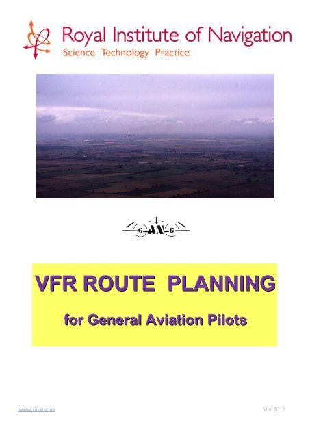
<strong>VFR</strong> ROUTE PLANNING<br />
for General Aviation Pilots<br />
www.rin.org.uk Mar 2012
1. General preparation<br />
Good planning is the basis <strong>of</strong> safe and easy navigation. First <strong>of</strong> all, information on the<br />
maps and charts to be used must be up-to-date. The AIP, AICs and NOTAMs may<br />
change the information on a map, and pilots must know how and where to find information<br />
in these documents. NATS publishes these, and chart amendments, free on the AIS web<br />
site. Using the most recently published charts reduces the work load considerably.<br />
2. Choosing the route<br />
The basic route can be chosen well in advance, and flown when conditions are suitable.<br />
a. Refer to the AIP and AICs, commercial flight guides and aerodrome web sites to<br />
check for procedures and any restrictions at your destination. Telephone for permission<br />
to land and useful additional information; advisable even if the aerodrome is not published<br />
as PPR. Note radio frequencies and the times they are manned, and plan your arrival to<br />
make a standard „overhead‟ join unless special procedures are published.<br />
Possible problems<br />
b. Choose a start point you can guarantee finding from any runway at your departure<br />
airfield. Study the most direct route to the destination. Check the chart, AICs and nav<br />
warnings for any hazards which might affect your route. Plan turning points to avoid flying<br />
close to these, and to restricted and controlled airspace (if you intend to fly through<br />
controlled airspace, plan a back-up route which avoids it). Look to stay away from<br />
unlandable terrain. Adjust turning points to simplify the choice and visibility <strong>of</strong> good fixes.<br />
Try to avoid flying over aerodromes, gliding sites etc; you may be forced to fly low<br />
because <strong>of</strong> weather and avoiding their traffic would increase your workload. Mark any<br />
remaining hazards and/or places you may need to make appropriate radio calls. Select<br />
suitable fixes along the route, and draw drift lines or other guidelines if desired.<br />
www.rin.org.uk 1 Mar 2012
Select turning points and fixes, plan radio calls<br />
c. Select a suitable altitude to fly. Decide what minimum altitude you are prepared to<br />
fly at (a safe margin above the highest obstacle near the route), and what minimum<br />
cloudbase you can accept, dividing the route into sectors if you wish. Controlled airspace<br />
may determine a maximum altitude also. Identify areas <strong>of</strong> possible bad weather, and safe<br />
routes to suitable diversion aerodromes if the weather or aircraft unserviceability makes<br />
that advisable. Check these aerodromes are available. Study your selected turning<br />
points and fix points to ensure you can identify them early from your direction <strong>of</strong> travel and<br />
can use them to avoid hazards. Remind yourself <strong>of</strong> the in-flight procedures you will use –<br />
refer to the RIN guide on “Visual <strong>Navigation</strong> Techniques”.<br />
d. Identify information (such as aerodrome and instrument traffic) you should get by<br />
radio, and plan when to ask for it. Practise making the relevant transmissions.<br />
e. Obtain a preliminary weather forecast (perhaps from TV or internet). Make an initial<br />
estimate <strong>of</strong> the time needed for the route in the probable wind conditions. Add a safety<br />
margin <strong>of</strong> at least half an hour (or 20% if greater) at this stage. Calculate the fuel required<br />
for that time. Check the times <strong>of</strong> darkness.<br />
f. Fill in the navigation log/flight planning form with all the information available.<br />
Tracks, distances, safe altitudes, variation, TAS (probably) and fuel consumption rates<br />
can be written down. Identify areas <strong>of</strong> probably high traffic density, such as „funnels‟<br />
through controlled airspace or terrain, or instrument approaches. List the radio<br />
frequencies <strong>of</strong> radar units, aerodromes, controlled airspace, and danger area services<br />
which you may need along the route or in case <strong>of</strong> diversion (check with NOTAMs and the<br />
NATS web site for amendments). List navigation aid frequencies, identification (you may<br />
wish to write down the morse dots and dashes), and protected ranges from the AIP and<br />
NOTAMs. Note any „listening squawks‟ near controlled airspace.<br />
www.rin.org.uk 2 Mar 2012
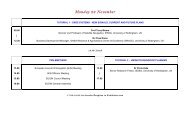
<strong>VFR</strong> Route Plan and Log<br />
Date Callsign Off chocks Take<strong>of</strong>f Land On chocks Wind Temp<br />
From To Min<br />
Alt<br />
Max<br />
Alt<br />
Tk<br />
T<br />
Drift<br />
Hdg<br />
T<br />
Hdg<br />
M<br />
TAS G/S Dist Time Fuel<br />
used<br />
28l/h<br />
Fuel<br />
rem<br />
ETA<br />
ATA<br />
LHst Bewl 1000 2500 218 3<br />
Bewl Adur 2000 2500 247 28<br />
Adur Chich 2000 5500 263 17<br />
C’ch Div (S’ham) 2000 5500 094 18<br />
Station Freq SSR QNH<br />
Farnboro East 123.225<br />
Shoreham App 123.15<br />
Chichester info 122.45<br />
Gatwick App 126.825<br />
London Info 124.750<br />
Volmet South 128.6<br />
Ident Freq PR Posn time<br />
MAY 117.9<br />
GWC 114.75<br />
SHM 332 10<br />
I-SHM 109.95<br />
Preliminary log entries<br />
g. Measure ranges and bearings to turning points from suitable navigation aids, and<br />
note them on the log and/or the chart.<br />
h. Load the route into your GPS set if you have one, check for major errors, and name<br />
it for future use.<br />
i. Study published radio failure procedures, and carry copies <strong>of</strong> these and <strong>of</strong><br />
interception procedures.<br />
j. Contact the UK Border Agency if leaving the UK (the Channel Islands and the Isle<br />
<strong>of</strong> Man are “<strong>of</strong>fshore islands” and not part <strong>of</strong> the UK). You may also need to contact<br />
Special Branch for flights travelling to Ireland or the <strong>of</strong>fshore islands. Obtain any<br />
diplomatic clearance if flying to or over a country which requires it.<br />
k. If flying abroad, make sure you know how to obtain weather and airspace<br />
information for the return, and that continental aerodromes you use for arrival and<br />
departure are acceptable. Plan to use only „international‟ aerodromes if you do not speak<br />
the local language well.<br />
www.rin.org.uk 3 Mar 2012
3. Preliminary aircraft preparation<br />
a. Check the aircraft is serviceable, and no scheduled maintenance is due while you<br />
may be flying. Check the insurance documents, the certificate <strong>of</strong> airworthiness and all<br />
other certificates you may need to take with you if travelling overseas.<br />
b. Arrange for any necessary survival equipment to be available.<br />
c. If landing away, arrange for chocks and tiedown equipment to be available to take<br />
with you.<br />
d. Make weight and balance calculations using a full fuel load and any survival and tiedown<br />
equipment. If too heavy, use your estimate <strong>of</strong> the fuel required and the actual<br />
weight <strong>of</strong> your passengers and intended baggage (don‟t take any more!) to carry out the<br />
calculations. If still too heavy, either carry fewer passengers or less fuel and plan to pick<br />
up more along the route. If anything changes you must re-calculate just before take-<strong>of</strong>f.<br />
e. Ensure you are familiar with the Flight Manual performance calculations, and that<br />
the Manual will be available before take-<strong>of</strong>f.<br />
f. Charge the batteries (or carry spares) for any electronic devices you intend to refer<br />
to.<br />
g. Arrange to have no more than the fuel you used for your calculations in the aircraft<br />
when you plan to fly.<br />
4. Route adjustment<br />
Just before the final navigation calculations, no earlier than the evening before the flight:<br />
a. Obtain the latest navigation warnings and check that nothing affects your planned<br />
route. Replan if necessary.<br />
b. Prepare the flight plan form if necessary (leaving UK airspace, flying IFR in<br />
controlled airspace) or desired. You are strongly advised to submit a flight plan if planning<br />
to fly over sparsely populated areas or the sea. Complete the route details and search<br />
and rescue fields, leaving the times empty until your final planning is complete.<br />
c. Ensure you have aerodrome charts (and approach charts if appropriate) for your<br />
destination and possible diversions. Plan your arrival to all likely runways.<br />
www.rin.org.uk 4 Mar 2012
5. Final planning<br />
On the day <strong>of</strong> the flight, recheck everything above, then finalise your planning.<br />
a. Obtain weather forecasts which cover the time <strong>of</strong> your intended flight. You will need<br />
aerodrome forecasts (TAFs) for your destination and possible diversions if they are<br />
published; otherwise use TAFs for nearby aerodromes. Obtain either a route forecast or<br />
an area forecast which covers the route, including significant weather, winds and<br />
temperatures. Study actual reports (METARs) to check and update the forecasts. All <strong>of</strong><br />
these are available on the UK Met Office web site. Check the local weather visually.<br />
b. If the forecast (adjusted by actual reports) suggests that cloudbase will be lower<br />
than your planned minimum, cancel or delay the flight. Check the crosswind components<br />
on the most likely runways at your destination and possible diversions. If the forecast<br />
crosswind is greater than your or the aircraft‟s capabilities, cancel or delay the flight.<br />
c. Using the forecast winds and temperatures for your planned altitude and time,<br />
finalise the navigation calculations. You may have to interpolate between different<br />
forecast levels. If making a long climb, use the wind and temperatures forecast for 2/3 <strong>of</strong><br />
the way up the climb. Write the winds and temperatures you intend to use on the log.<br />
Decide and note your IAS. Make rough MDR heading calculations, then use a computer<br />
for detailed figures, and adjust for variation. Calculate groundspeed, then time and fuel<br />
required for each leg, and timings to each fix. Write down the fuel remaining at the end <strong>of</strong><br />
each leg, and check that the total fuel required (including a safety margin) is less than the<br />
fuel load you intend carrying. Compare your final figures with your previous estimates; if<br />
the difference is great without an obvious reason, check them again.<br />
d. Make a final check <strong>of</strong> your planning by cross-referring between your log and your<br />
chart. You may wish to write headings and timings onto the chart, and a wind arrow with<br />
windspeed and maximum drift. At each turning point, visualise the amount <strong>of</strong> turn you are<br />
going to make (a protractor error can be spotted at this stage) and the features you will<br />
see. Remind yourself <strong>of</strong> your fix points, and how to find your start point.<br />
e. Complete the ATC flight plan form if required and submit it more than 60 minutes<br />
before start-up. Ensure ATC can contact you if there is a problem.<br />
f. Complete take-<strong>of</strong>f and landing performance calculations. If you need more than the<br />
distances available after taking all safety factors into account, cancel or delay the flight.<br />
g. Make a final check by telephone to NATS AIS, or a last minute check on their website,<br />
that no temporary restricted or controlled airspace will affect your flight.<br />
h. If taking <strong>of</strong>f from an aerodrome with an air traffic service unit, you may need to<br />
telephone your intended departure details. Brief a friend at your UK destination to inform<br />
the nearest air traffic services unit if you do not arrive by the time your fuel has run out.<br />
www.rin.org.uk 5 Mar 2012
6. Aircraft completion<br />
a. Check the aircraft log for unservicabilities. Pack all necessary certificates.<br />
b. Pre-flight check the aircraft. Check visually that fuel tank contents agree with your<br />
intentions and expectations and refuel if necessary. Top up oil.<br />
c. Weigh all baggage. If within the figures used in the calculations, load and secure it<br />
in the places you had intended. If too heavy, leave something behind.<br />
d. Brief passengers on safety, evacuation, and how to help by looking out for other<br />
aircraft and ground features.<br />
e. Load the route into your GPS set if not already done. Check it for gross errors and<br />
activate it before take-<strong>of</strong>f.<br />
f. Make sure any filed flight plan will be activated once airborne.<br />
g. Check compass deviation card and alter planned headings if necessary<br />
h. Wear life preservers if flying over water.<br />
i. Finally check your log, map and all charts are in the cockpit and handy.<br />
Have a safe flight!<br />
www.rin.org.uk 6 Mar 2012
ABOUT THIS GUIDE<br />
The <strong>Royal</strong> <strong>Institute</strong> <strong>of</strong> <strong>Navigation</strong> since its inception has aimed to improve the<br />
standards <strong>of</strong> navigation on land, sea and in the air. To that end, it has produced<br />
guidance material to assist recreational pilots (the aerial navigators <strong>of</strong> today),<br />
including a syllabus for GPS training and a companion to this volume, on Visual<br />
<strong>Navigation</strong> Techniques.<br />
This booklet is intended to guide pilots through the most important steps in planning<br />
a safe and hopefully relaxing cross-country flight in a light aircraft. It is not intended<br />
to replace regulatory information or <strong>of</strong>ficial publications with which pilots are required<br />
to be familiar, and which supersede any conflicting advice given here. Because<br />
aviation information changes rapidly, chart and frequency information given in<br />
examples must not be used for flight planning.<br />
There is no requirement for anyone to be formally associated with the RIN in order<br />
to use this or any other <strong>of</strong> its training material. However, if users feel an affinity with<br />
the aims <strong>of</strong> the <strong>Institute</strong>, various categories <strong>of</strong> individual and group membership are<br />
available as detailed on the RIN web site www.rin.org.uk .<br />
The <strong>Royal</strong> <strong>Institute</strong> <strong>of</strong> <strong>Navigation</strong> (RIN) is a learned society formed in 1947. It has three main aims:<br />
to unite all those with a pr<strong>of</strong>essional or personal interest in any aspect <strong>of</strong> navigation in one unique body;<br />
to further the development <strong>of</strong> navigation in every sphere; and<br />
to increase public awareness <strong>of</strong> both the art and science <strong>of</strong> navigation, how it has shaped the past, how it impacts our<br />
world today, and how it will affect the future.<br />
www.rin.org.uk 7 Mar 2012