

Eastern Africa Coastal Forest Programme: Regional Workshop ...
Eastern Africa Coastal Forest Programme: Regional Workshop ...
Eastern Africa Coastal Forest Programme: Regional Workshop ...

Create successful ePaper yourself
Turn your PDF publications into a flip-book with our unique Google optimized e-Paper software.
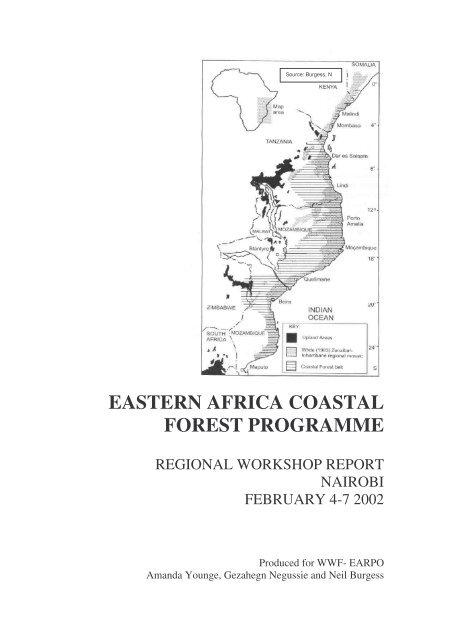
Source: Burgess, N<br />
EASTERN AFRICA COASTAL<br />
FOREST PROGRAMME<br />
REGIONAL WORKSHOP REPORT<br />
NAIROBI<br />
FEBRUARY 4-7 2002<br />
Produced for WWF- EARPO<br />
Amanda Younge, Gezahegn Negussie and Neil Burgess
EASTERN AFRICA COASTAL FOREST<br />
PROGRAMME<br />
REGIONAL WORKSHOP REPORT<br />
NAIROBI<br />
FEBRUARY 4-7 2002<br />
WWF-EARPO would like to acknowledge the following organisations whose support<br />
made this workshop successful:<br />
The Ford Foundation<br />
WWF – Switzerland<br />
Produced for WWF-EARPO<br />
by<br />
Amanda Younge with the assistance of Gezahegn Negussie and Neil Burgess<br />
Amanda Younge CC<br />
53 Hofmeyr Street,<br />
Gardens 8001<br />
Cape Town<br />
South <strong>Africa</strong><br />
Tel: +27-21-424-1838<br />
Fax: +27-21-426-5824<br />
Email: Amanda@mindspring.co.za<br />
<strong>Eastern</strong> <strong>Africa</strong> <strong>Coastal</strong> <strong>Forest</strong>s - 2 - <strong>Workshop</strong> Report, Nairobi February 4-7 2002
EASTERN AFRICA COASTAL FOREST PROGRAMME<br />
REGIONAL WORKSHOP REPORT<br />
NAIROBI<br />
FEBRUARY 4 -7 2002<br />
EXECUTIVE SUMMARY<br />
The eastern <strong>Africa</strong>n coastal forest ecoregion is recognised as one of <strong>Africa</strong>’s centres of<br />
species endemism, and is distributed over six countries (Somalia, Kenya, Tanzania,<br />
Mozambique, Zimbabwe and Malawi). Most is found in Kenya, Tanzania and Mozambique,<br />
which form our focal region. The coastal forests are fragmented, small and surrounded by<br />
poor communities that have a high demand for land and forest resources. Although coastal<br />
forests have significant cultural and traditional values for local communities, they do not<br />
receive adequate support from the relevant government authorities and international<br />
conservation institutions.<br />
WWF has over 10 years research and conservation experience on the eastern <strong>Africa</strong> coastal<br />
forests in Kenya, Tanzania and Mozambique and would like to build on its past successes by<br />
supporting the <strong>Eastern</strong> <strong>Africa</strong> <strong>Coastal</strong> <strong>Programme</strong> development processes. The major<br />
challenges to conserving these forests through the EACFP are dealing with three different<br />
countries with different policies, attracting and maintaining government and donor interests,<br />
identifying major stakeholders and their role in the programme and integrating and sustaining<br />
existing coastal forest initiatives in the region.<br />
In order to address the threats facing this region effectively, conservation of the <strong>Eastern</strong><br />
<strong>Africa</strong>n <strong>Coastal</strong> <strong>Forest</strong>s needs to happen within a coherent framework, developed with<br />
partners and stakeholders. To initiate the regional partnership-based programme, WWF<br />
<strong>Eastern</strong> <strong>Africa</strong>n <strong>Regional</strong> <strong>Programme</strong> Office (WWF-EARPO) held a workshop with<br />
stakeholders from Kenya, Mozambique and Tanzania in February 2002. Thirty-one people<br />
attended the workshop from Tanzania, Mozambique and Kenya., and were drawn from<br />
government, NGOs and universities.<br />
The programme aimed to update existing maps on the region, undertake a threats and root<br />
causes analysis, develop a vision statement and a set of regional and country conservation<br />
targets and actions plans, and to set out the next steps for putting the plan into action. After<br />
receiving reports on the status of coastal forest conservation in each country, a mapping<br />
exercise was undertaken to update and correct existing maps of the eastern <strong>Africa</strong>n coastal<br />
forests.<br />
In order to guide the development of the strategy, the workshop developed a draft<br />
Biodiversity Vision for the EACF as follows:<br />
“<strong>Coastal</strong> <strong>Forest</strong>s of eastern and south-eastern <strong>Africa</strong> are conserved, managed and<br />
sustainably utilized for the benefit of present and future generations.”<br />
Working in country groups, participants updated maps of distribution and extent of forests<br />
using GIS and identified new forest areas and biodiversity hotspots along the eastern and<br />
south eastern <strong>Africa</strong>n coast, especially in Mozambique. After discussions, they also agreed on<br />
the terms and definitions used in relation to coastal forests.<br />
<strong>Eastern</strong> <strong>Africa</strong> <strong>Coastal</strong> <strong>Forest</strong>s - 3 - <strong>Workshop</strong> Report, Nairobi February 4-7 2002
The workshop identified the major causes of forest loss and underlying forces driving this<br />
process. The most important threats to coastal forests are agricultural conversion, charcoal<br />
burning and fuel wood, uncontrolled fires, unsustainable logging and unplanned settlement.<br />
Other threats identified were inappropriately-placed roads and infrastructure, uncontrolled<br />
removal of non-timber products, destructive mining practices and poaching.<br />
<strong>Workshop</strong> participants also identified the root causes of the threats at local, national and<br />
ecoregional levels. At the local level, the most important causes of forest loss were poverty,<br />
lack of alternative livelihood options for populations living adjacent to the forests, inadequate<br />
law enforcement, low awareness of the value of coastal forests and consequences of their loss,<br />
lack of recognition to cultural values and indigenous knowledge on forests and inadequate<br />
information on the forest resource. In Kenya and Tanzania corruption was identified as a<br />
significant local cause of logging, charcoal burning and unplanned human settlements.<br />
Inadequate environmental impact assessments were cited as a cause of inappropriate<br />
agricultural practices in these two countries. Common to all three countries was inadequate<br />
capacity and resources for conservation management and weak civil society. Global climate<br />
change, structural adjustment and international markets/trade were identified as causes of<br />
coastal forest loss at the global level.<br />
Conservation targets were developed for the East <strong>Africa</strong>n <strong>Coastal</strong> <strong>Forest</strong> Ecoregion as a<br />
whole, as well as for each country represented in the ecoregion. The regional targets<br />
developed were:<br />
1. Decline in quality and quantity of existing coastal forests within protected areas halted by<br />
2010.<br />
2. At least 30% of unprotected coastal forests placed under protection status by 2010.<br />
3. Annual rate of loss of unprotected coastal forests to agriculture, illegal logging and<br />
charcoal burning reduced by at least 50% by 2010.<br />
4. Effective management capacity for protected coastal forests in place and operational by<br />
2010.<br />
5. At least 5 coastal forest landscape restoration initiatives implemented by 2007.<br />
6. 30% of coastal forests support sustainable activities contributing to poverty alleviation<br />
and economic development by2010 without harming habitat and species values.<br />
7. <strong>Forest</strong> reserves of EACF regarded as protected areas in terms of IUCN criteria.<br />
Each country working group defined conservation targets for that country. Groups then<br />
identified the actions needed to achieve these targets, with an indication as to which<br />
stakeholders needed to be involved in each action.<br />
In order to take the process forward, WWF was requested to continue with facilitating the<br />
regional process through a <strong>Regional</strong> Task Force. Each county represented will choose an<br />
interim focal point to lead the establishment of a country task force on coastal forests to help<br />
push the process forward. The task force will follow up the targets and actions developed<br />
during the working group sessions to enable the regional programme to move forward.<br />
Sharing experiences will also be encouraged. By April 2002, the regional co-ordination team<br />
should be in place. WWF agreed to circulate the workshop report in March 2002. In each<br />
country, national stakeholder workshops will be held to revisit and refine the action plan as it<br />
applies in each country, as well as to build stakeholder commitment to implementation.<br />
The Tanzanian and Kenyan Protected Area institutions in collaboration with WWF will<br />
finalise their documentation and apply for GEF-PDF Block B funding for developing their<br />
National <strong>Coastal</strong> <strong>Forest</strong> Strategic Action Plans. WWF will assess the possibilities for<br />
Mozambique for accessing UNDP-GEF money and also approach its donors for arranging<br />
some mid term funding for implementing programme’s regional and national activities.<br />
<strong>Eastern</strong> <strong>Africa</strong> <strong>Coastal</strong> <strong>Forest</strong>s - 4 - <strong>Workshop</strong> Report, Nairobi February 4-7 2002
A synthesis report would be produced and distributed to the donor community, workshop<br />
participants and WWF networks by February 2002 and a draft programme document by June<br />
2002. The refined action plan will be finalised by December 2002.<br />
Participants praised the workshop for being productive, well-structured, well-facilitated and<br />
giving good feedback in written form at the end. The overwhelming majority of respondents<br />
indicated that they were satisfied with the progress that had been achieved.<br />
<strong>Eastern</strong> <strong>Africa</strong> <strong>Coastal</strong> <strong>Forest</strong>s - 5 - <strong>Workshop</strong> Report, Nairobi February 4-7 2002
CONTENTS<br />
EASTERN AFRICAN COASTAL FOREST<br />
PROGRAMME<br />
REGIONAL WORKSHOP REPORT<br />
NAIROBI<br />
FEBRUARY 4 -7 2002<br />
1. Background<br />
2. Purpose of workshop<br />
3. Attendance<br />
4. <strong>Programme</strong><br />
5. Opening inputs<br />
6. Country reports<br />
7. Mapping<br />
8. Vision<br />
9. Root causes analysis<br />
10. Conservation targets<br />
11. Action plan<br />
12. Way forward<br />
13. Closing address<br />
14. <strong>Workshop</strong> evaluation<br />
15. Logframe analysis<br />
LIST OF TABLES<br />
Table 1: Number and area (km 2 ) of coastal forests in eastern <strong>Africa</strong>n countries in 1992<br />
and 2002<br />
Table 2: Number of endemic species in the coastal forests and non-forested vegetation<br />
of the coastal strip of eastern <strong>Africa</strong><br />
Table 3: Proposed next steps: <strong>Regional</strong> co-ordination<br />
ANNEXURES<br />
Annex A:<br />
Annex B:<br />
Annex C:<br />
Annex D:<br />
Annex E:<br />
Annex F:<br />
Annex G:<br />
Annex H:<br />
Annex I:<br />
Annex J:<br />
Annex K:<br />
Annex L:<br />
Annex M:<br />
Annex N:<br />
Annex O:<br />
Annex P:<br />
<strong>Workshop</strong> Terms of Reference<br />
Attendance List and Contact Details<br />
<strong>Workshop</strong> <strong>Programme</strong><br />
Opening Input<br />
Tanzania Country Report<br />
Mozambique Country Report<br />
Kenya Country Report<br />
References<br />
Formal Definition of The <strong>Eastern</strong> <strong>Africa</strong>n <strong>Coastal</strong> <strong>Forest</strong>s<br />
List of <strong>Eastern</strong> <strong>Africa</strong>n <strong>Coastal</strong> <strong>Forest</strong>s in Somalia, Kenya, Tanzania and<br />
Mozambique<br />
Species of Animals endemic to the <strong>Coastal</strong> <strong>Forest</strong> Mosaic Ecoregions<br />
Threats and Root Causes Analysis<br />
Action Plan: Tanzania, Mozambique and Kenya<br />
Way Forward: Country Actions<br />
<strong>Workshop</strong> Evaluation Results<br />
Updated Maps (On CD)<br />
<strong>Eastern</strong> <strong>Africa</strong> <strong>Coastal</strong> <strong>Forest</strong>s - 6 - <strong>Workshop</strong> Report, Nairobi February 4-7 2002
EASTERN AFRICAN COASTAL FOREST PROGRAMME<br />
REGIONAL WORKSHOP REPORT<br />
NAIROBI<br />
FEBRUARY 4 -7 2002<br />
1. BACKGROUND<br />
The World Wide Fund for Nature (WWF) has singled out the <strong>Eastern</strong> <strong>Africa</strong>n<br />
<strong>Coastal</strong> forest for conservation because of its richness in biodiversity,<br />
because it is one of <strong>Africa</strong>’s centres of endemism, and due to the intense<br />
threats to the survival of forest habitats in the area. Threats to the <strong>Eastern</strong><br />
<strong>Africa</strong>n <strong>Coastal</strong> <strong>Forest</strong>s are and continue to be linked to conversion to<br />
farmland, fragmentation, settlement, changes in land-use patterns and lack of<br />
effective and integrated policies, coupled with inadequate / ineffective<br />
management structures. Current forest destruction trends are impacting on a<br />
wide range of terrestrial and marine resources in the three countries covered<br />
under the programme. For example, the sustainable production potentials and<br />
the services they provide to the local livelihoods continue to decline.<br />
WWF’s commitment to addressing these threats is manifested by its past and current<br />
projects in Kenya (Kaya forest project in collaboration with NMK and most recently<br />
with the Ford Foundation), Tanzania (Lowland <strong>Coastal</strong> <strong>Forest</strong> Project) and in<br />
Mozambique (Bazzaruto National Park).<br />
Two major lessons have been learned from these projects. First, conservation<br />
interventions require active support from political institutions, local communities and<br />
forest management authorities. Secondly, coastal forest conservation and sustainable<br />
management problems require an integrated approach involving partnership building<br />
between local and central government, private sector and donors institutions through<br />
short and long-term landscape level approaches.<br />
In order to address these issues effectively, it was felt that conservation of the <strong>Eastern</strong><br />
<strong>Africa</strong>n <strong>Coastal</strong> <strong>Forest</strong>s should happen within a coherent framework, developed with<br />
partners and stakeholders. Short-term approaches would aim at addressing sustainable<br />
management and conservation issues through scaled-up project activities in to a<br />
programme. Long-term approaches would aim at addressing socio-economic<br />
problems impacting on rural livelihoods and biodiversity, national and trans-boundary<br />
policy issues and mechanisms for a sustainable financing system.<br />
In order to initiate the regional partnership-based coastal forest programme, WWF<br />
<strong>Eastern</strong> <strong>Africa</strong>n <strong>Regional</strong> <strong>Programme</strong> Office (WWF-EARPO) held a workshop with<br />
stakeholders from Kenya, Mozambique and Tanzania in February 2002. This report<br />
contains the findings of that workshop.<br />
2. PURPOSE OF WORKSHOP<br />
The purpose of the workshop was to deliberate on the three countries national coastal<br />
forest resource issues, extent and status and deliver a regional synthesis with a view<br />
to contribute to the programme’s planning processes. Further, the workshop was<br />
<strong>Eastern</strong> <strong>Africa</strong> <strong>Coastal</strong> <strong>Forest</strong>s - 7 - <strong>Workshop</strong> Report, Nairobi February 4-7 2002
designed to develop an East <strong>Africa</strong> <strong>Coastal</strong> <strong>Forest</strong> <strong>Programme</strong> vision, strategy and<br />
action plan for realizing national and transboundary coastal conservation and<br />
livelihood aspirations (see Annex A for the terms of reference of the workshop).<br />
3. ATTENDANCE<br />
Invitations to the workshop were sent to 38 people representing government Protected<br />
Area institutions, NGO, CBOs, Donors and international institutions working in the<br />
subregion. <strong>Workshop</strong> attendance was very good. A total of 31 people participated,<br />
eight from Tanzania, five from Mozambique and twelve from Kenya, supported by a<br />
workshop team of six . (See Annex B for details of participants names and addresses).<br />
Participants were drawn from government, NGOs and universities. Unfortunately,<br />
some key actors such as IUCN and GEF/UNDP representatives and senior members<br />
of the Kenya government were unable to attend due to prior commitments.<br />
4. PROGRAMME<br />
The programme ran over three and a half days. It was ambitious, intensive and<br />
focussed heavily on group work in country-based groups. This was necessitated by<br />
the limited information available on forest typology and extent, which could<br />
otherwise have served as an alternative basis for working group formation.<br />
The programme (see Annex C) attempted to achieve a number of objectives: to<br />
update existing maps on the region, undertake a threats and root causes analysis,<br />
develop a vision statement, a set of regional and country conservation targets and<br />
actions plans, and to set out the next steps for putting the plan into action.<br />
The programme ran as follows:<br />
Day 1: Knowledge and Resource Assessment<br />
• Introduction, background and purpose<br />
• Updating available information on forest extent, types and endemic species on<br />
maps<br />
• <strong>Forest</strong> terms and definitions<br />
Day 2: Vision, Threats, Causes And Targets<br />
• Preliminary Vision Development<br />
• Identifying threats and opportunities<br />
• Analyzing root causes<br />
• Setting and prioritising Conservation Targets<br />
Day 3: Actions To Meet Targets<br />
• Identifying priority actions to meet programme targets<br />
• Social event (evening)<br />
<strong>Eastern</strong> <strong>Africa</strong> <strong>Coastal</strong> <strong>Forest</strong>s - 8 - <strong>Workshop</strong> Report, Nairobi February 4-7 2002
Day 4: Putting The Plan Into Action<br />
• Next steps: co-ordination, fundraising, lobbying, stakeholder consultation, finetuning<br />
and project ideas<br />
• Way forward<br />
• Closure<br />
5. OPENING INPUTS<br />
WELCOMING ADDRESS<br />
Dr Hermann Mwageni, Acting Country Representative in the WWF Tanzania<br />
<strong>Programme</strong> Office, opened the meeting. He noted that all participants share<br />
one thing in common, a concern for the coastal forests of <strong>Eastern</strong> <strong>Africa</strong>, from<br />
Mozambique to Kenya, which are very rich in terms of biodiversity and<br />
crucial for livelihoods. There are similarities in the problems facing the forests<br />
and facing conservation agencies. The workshop was an opportunity to share<br />
experiences and work towards solving these problems together. In the past,<br />
WWF’s work had been based on a site-specific approach, and the success had<br />
been limited. It was now high time to look at the big picture, and come up with<br />
strategies at the ecoregional /landscape level. An integrated approach and a<br />
common effort was needed, which would hopefully bring in a wider range of<br />
stakeholders and attract more substantial funding. The objective of the<br />
workshop was to develop a programme vision and strategic actions at regional<br />
and national levels. WWF wants to support the integration of regional efforts,<br />
but needs partners, more funding and more stakeholders to become part of the<br />
process, and hopefully the workshop would start this process happening.<br />
WORKSHOP INTRODUCTION<br />
Gezahegn Negussie, the co-ordinator of WWF-EARPO’s <strong>Eastern</strong> <strong>Africa</strong>n <strong>Coastal</strong><br />
<strong>Forest</strong>s <strong>Programme</strong>, gave an introductory input which set the context for the<br />
workshop (see Annex D). He made the following points:<br />
The coastal forests of <strong>Eastern</strong> <strong>Africa</strong> (EACF) are small highly fragmented remnants,<br />
consisting of over 250 separate forest patches most of which are less than 500 ha in<br />
size. They are distributed over six <strong>Africa</strong>n countries: Somalia, Kenya, Tanzania,<br />
Mozambique, Zimbabwe and Malawi.<br />
The EACF forms part of the Moist Coasts fauna and flora, which is one of <strong>Africa</strong>’s<br />
four centers of endemism. There is an opportunity to have a significant conservation<br />
gain for an investment in a few thousands of hectares. The region is one of WWF’s<br />
Global 200 Ecoregions and a priority ecoregional programme for WWF in the subregion.<br />
It is also one of the three terrestrial ecoregions that WWF will work with its<br />
partners in <strong>Africa</strong>.<br />
The EACF are threatened by deforestation, changing land-use patterns, high<br />
population density at close proximity to coastal forests, fragmentation, lack of legal<br />
frameworks for conservation and lack of government interest in and resource for<br />
forest conservation.<br />
<strong>Eastern</strong> <strong>Africa</strong> <strong>Coastal</strong> <strong>Forest</strong>s - 9 - <strong>Workshop</strong> Report, Nairobi February 4-7 2002
Opportunities exist for improved forest conservation: there is strong will from<br />
partners in the subregion, WWF and its partners have long experience and capacity to<br />
undertake forest conservation, there are supportive national environmental policies in<br />
place, and there is great potential for revenues and to contribute to the national<br />
economy. There is community support and respect for coastal forests for cultural and<br />
traditional reasons, biological and socio-economic data is available, and WWF is<br />
committed to scaling up its coastal forest activities to a programme level.<br />
There are a number of challenges facing forest conservation. These include a number<br />
of countries with different policies towards forests and land use, difficulties with<br />
defining coastal forests and determining their extent and boundary, the fragmentation<br />
of coastal forests and numerous players involved, how to identify key threats, gaps<br />
and programme interventions as well as how to identify national priorities and action<br />
plans targeting coastal forests. Other challenges include attracting and maintaining<br />
donors and partners interest, identifying major stakeholders and determining their role<br />
in the planning and implementation of the programme and sustaining and integrating<br />
WWF’s and others existing coastal forest projects in the EACFP.<br />
Lessons from work that has been done in the region have shown that work at sitespecific<br />
project level resulted in limited impact on the broad ecological problems of<br />
the coastal forests. Linkages between site level interventions and landscape level<br />
forest services were not made, and there was limited understanding on how to forge a<br />
common vision that builds on linkages between and within different projects and<br />
forest components. There is a lack of an institutional framework that addresses crossborder<br />
conservation and policy issues, and relatively limited capacity to address<br />
community participation issues. There is an absence of an initial baseline survey and<br />
other data, which makes planning and monitoring difficult, and a lack of frameworks<br />
where conservation and development practitioners debate common and crosscutting<br />
issues.<br />
In discussion, it was emphasized by Neil Burgess that the process of conserving the<br />
EACF will need to be a collaborative effort between countries, agencies, NGOs and<br />
other bodies. Gezahegn emphasized that the workshop objective was for potential<br />
partners to develop a common vision for the resource that they share a common<br />
concern and responsibility for, and to develop a shared action plan to ensure that the<br />
actions of all agencies contribute to achieving the vision. One participant pointed out<br />
that agriculture is a key stakeholder, and needs to be drawn in to the process. Another<br />
participant felt that UNEP/GEF and IUCN should have been part of the workshop. It<br />
was pointed out that they had been invited but had been unable to attend. However,<br />
they would receive a briefing and workshop documentations after the workshop.<br />
6. COUNTRY REPORTS<br />
TANZANIA REPORT<br />
The lowland coastal forests of Tanzania are represented by a few remaining patches<br />
of reserves and unreserved forests. These forests harbour a unique diverse of flora and<br />
fauna which show much endemism. Pressure on these forests is severe due to<br />
unsustainable human livelihood activities such as shifting cultivation, illegal timber<br />
extraction, forest fires, hunting, encroachment for farming and residence.<br />
Based on Frontier surveys (Frontier-Tanzania 1989-1995) and Burgess and Clarke<br />
(2000), forest sites can be roughly prioritised based on their biodiversity potential and<br />
<strong>Eastern</strong> <strong>Africa</strong> <strong>Coastal</strong> <strong>Forest</strong>s - 10 - <strong>Workshop</strong> Report, Nairobi February 4-7 2002
possibly the level of threats in the areas. <strong>Forest</strong> that are noticeably rich in species for<br />
their size and forests with relatively high endemism Pugu, Rondo Plateau, Litipo,<br />
Matumbi hills, Kichi Hills, Zaraninge, Pangani falls, Litipo, Pindiro and Mlola. More<br />
surveys and analysis are required to obtain enough data before priority setting.<br />
Since 1990s WWF realised the facts that coastal forests in Tanzania have global<br />
biodiversity and national socio-economic values, and are highly prioritised by the<br />
<strong>Forest</strong> Department through the Tanzania <strong>Forest</strong> Action Plan (TFAP, 1988) for<br />
conservation due to their values, and are facing increasing pressure and threats<br />
resulting from a combination of human activities including: shifting cultivation,<br />
illegal timber extraction, forest fires, commercial and subsistence hunting, and<br />
encroachment for farming and settlement.<br />
In response, WWF began a project in 1991which strives to achieve the conservation<br />
of coastal forests through a combination of active protection measures and local<br />
community’s efforts, in collaboration with the <strong>Forest</strong> Department, district authorities,<br />
village governments, local NGOs and other donor agencies. The goal of the project is<br />
to conserve representative samples of lowland coastal forests in Tanzania. The<br />
immediate objectives are:<br />
Villages, districts and forest department have the institutional capacity to manage<br />
and protect key forests in coast region<br />
Ecosystems within forest reserves are conserved through efficient management<br />
systems acceptable to, and including the participation of, local communities.<br />
Local communities develop an alternative resource base to reduce pressure on<br />
selected coastal forests<br />
Local communities attain greater awareness on conservation and sustainable<br />
resource use through a programme of education and awareness.<br />
Biological and socio-economic surveys and monitoring provide a basis for forest<br />
reserve management<br />
Lessons learned and recommended next steps with EACF conservation:<br />
• The current new national <strong>Forest</strong> Policy (1998) which advocates on involvement<br />
of all key stakeholders in managing forest resources, is a good opportunity for<br />
initiating a broader coastal forest programme involving a wide range of<br />
stakeholders.<br />
• Following tangible success of existing site level projects a scaled up regional<br />
programme is now necessary as it allows for a holistic approach to tackling root<br />
causes and ensure upgraded capacity for impact on conservation.<br />
• Regulation of timber trade in the region needs emphasis in the proposed<br />
programme borrowing some experiences by the people and plant programme in<br />
Kenya, where wood caring project had much positive impact.<br />
• The EACP should come up with longer proposed time frame (10-15 years) to<br />
provide for more capacity building potential and involvement of partners.<br />
• Assess alternative resource and income generating activities for human livelihood<br />
and marketing options.<br />
• The EACP should mainly be playing a facilitation role to the local partners and<br />
very mini9mum implementation role at field level to strengthen local programme<br />
ownership, responsibility, knowledge base and consequently sustainability of<br />
programme initiatives.<br />
• Considering scattered national coastal forest initiatives by different players there<br />
is a need to establish national coastal forests network/partnership and EACF<br />
initiatives co-ordinated in a regional scale.<br />
<strong>Eastern</strong> <strong>Africa</strong> <strong>Coastal</strong> <strong>Forest</strong>s - 11 - <strong>Workshop</strong> Report, Nairobi February 4-7 2002
• EACFP needs to develop standardised methodology for surveys and associated<br />
database and mapping and GIS facilities these will enhance completion of status<br />
report of <strong>Eastern</strong> <strong>Africa</strong>n <strong>Coastal</strong> <strong>Forest</strong>s.<br />
While national field projects are concerned with conservation of coastal forests<br />
through field and policy works, they do not have as part of their operational principal<br />
a concept that define linkages between the different projects. Lack of an overall<br />
programme for the <strong>Eastern</strong> <strong>Africa</strong> <strong>Coastal</strong> <strong>Forest</strong>s has been a concern articulated by<br />
different institutions and organisations like WWF with interest in the area and WWF<br />
in <strong>Eastern</strong> <strong>Africa</strong> commits itself to establishing a <strong>Coastal</strong> <strong>Forest</strong> <strong>Programme</strong>. Besides<br />
the growing interest and interventions in the EACF from different organisations and<br />
donor agencies, there are also possibilities to complement and create synergies<br />
between the EACF programmes and other WWF programmes, such as the East<br />
<strong>Africa</strong>n Marine Ecoregion, The People and Plants <strong>Programme</strong> and the forest<br />
Landscape restoration initiatives. See Annex E for the Tanzania Country Report.<br />
MOZAMBIQUE REPORT<br />
Mocambique has a population of 17 million people, two thirds of whom live along<br />
the coast. They have high levels of poverty and illiteracy, and are mainly involved in<br />
agriculture, fisheries and industrial activity.<br />
The Mozambican Coast is 2 770 km long and is divided into the Coral Coast (770<br />
km), Swamp Coast (978 km), Parabolic Dune Coast (850 km), Monoclinal Coast and<br />
the continental shelf . There is a diversity of habitats/ecossystems (intertidal zones,<br />
beaches, deltas, coral reefs) and flora and fauna (mangroves, seagrasses, marine<br />
mammals, fish, avifauna).<br />
The main <strong>Coastal</strong> <strong>Forest</strong> Types (Saket, 1994) are low forest, thicket, grassland<br />
(wooded and grassland), mangrove and vegetation on dunes.<br />
Areas of special concern in the country are the Low <strong>Forest</strong> (C. Delgado), Low <strong>Forest</strong><br />
(Mossuril/Moma), High & Low <strong>Forest</strong> Complex (Marromer/Muanza), and Low<br />
<strong>Forest</strong> (Maputo/Matutuine).<br />
Resource use patterns consist mainly of subsistence agriculture (slash and burn),<br />
cmmercial logging (selected species), mining (northern region), tourism (poor law<br />
enforcement), andresource exploitation for subsistence.<br />
Policy and legislation relating to the coastal zone includes National Policy for <strong>Coastal</strong><br />
Zones Management, Policy and Strategy for <strong>Forest</strong> and Wildlife, the Environmental<br />
Law, the Tourism Strategy and the Land Law. A number of international conventions<br />
apply as well.<br />
The main constraints to coastal resources management include weak coordination<br />
amongst involved agencies, lack of integrated and holistic land use plans, limited<br />
technical capacity to monitor and control coastal resource management, llimited<br />
financial resources, lack of alternative sources for subsistences (generalised poverty)<br />
and generalised corruption.<br />
What is needed to improve conservation of coastal forests includes coastal forests<br />
mapping and inventories, identification of coastal sensitive forests, habitats and<br />
appropriate management plans, law enforcement and institutional coordination,<br />
<strong>Eastern</strong> <strong>Africa</strong> <strong>Coastal</strong> <strong>Forest</strong>s - 12 - <strong>Workshop</strong> Report, Nairobi February 4-7 2002
financial support for research, management and monitoring of coastal zone, and<br />
integrated development of coastal zones. <strong>Regional</strong> and international coordination<br />
should be encouraged. See Annex F for the Mozambique Country Report.<br />
A presentation was also made on a case study of the Cabo Delgado conservation<br />
initiative by a member of the Mocambique delegation.<br />
KENYA REPORT<br />
The Kenya <strong>Coastal</strong> <strong>Forest</strong> System has an estimated total area of closed forest of<br />
787km 2 and an estimated total area of woodland/bushland of 120 000 ha. Of this, 50<br />
790 ha is in forest reserves, 114 460 ha in national reserves and 16 000 ha remains<br />
ungazetted (see Annex G for the Kenya Country Report).<br />
It is an area of high endemism, threatened by clearing for agriculture, clearing for real<br />
estate development, logging for sawn wood, wood carving, pole cutting, mining and<br />
elephant damage (on specific sites).<br />
The sacred Kaya <strong>Forest</strong>s are situated in the coastal plain and hills of Kenya. They<br />
tend to be residual patches (av.10ha - 200ha) of once extensive diverse lowland forest<br />
of <strong>Eastern</strong> <strong>Africa</strong> occurring within the Zanzibar-Inhambane <strong>Regional</strong> Mosaic. The<br />
Kayas are very botanically diverse and have a high conservation value as determined<br />
by various biological studies. More than half of Kenya’s rare plants are found in the<br />
Coast Region, many within these forests on the coastal strip.<br />
According to local traditions the forests historically sheltered small fortified villages.<br />
The sites of the original settlements, often marked by forest clearings, were<br />
maintained by the communities led by their Elders, as sacred places of ritual, and<br />
burial grounds. Cutting of trees and destruction of vegetation around these sites was<br />
prohibited the main aim being to preserve the surrounding ‘Kaya’ forest as a screen or<br />
buffering environment for the clearings. The Government has from 1992 gazetted a<br />
number of them as National Monuments through the National Museums of Kenya.<br />
The National Museums’ <strong>Coastal</strong> <strong>Forest</strong> Conservation Unit has been undertaking a<br />
conservation programme for the Kayas with support from the World Wide Fund for<br />
Nature WWF since 1992.<br />
The challenges ahead for Kenya coastal forests and Kaya forests include:<br />
• Developing a collaboration framework for institutions and community groups<br />
involved in kaya and coastal forest conservation.<br />
• Exploiting the evolving policy and legal environment favouring community<br />
participation<br />
• Strengthening local community organizations to undertake conservation and<br />
development activities<br />
• Developing and implementing clear participatory management strategies and<br />
rules for the kayas and other coastal forests<br />
• Expanding livelihood choices and opportunities for local communities to reduce<br />
harmful dependence on kayas and coastal forests<br />
<strong>Eastern</strong> <strong>Africa</strong> <strong>Coastal</strong> <strong>Forest</strong>s - 13 - <strong>Workshop</strong> Report, Nairobi February 4-7 2002
• Identifying and developing alternatives sources of forest based raw material.<br />
• Securing sustainable sources of funding to support coastal forest conservation<br />
activities at various levels<br />
• Completing and consolidating the coastal forest information database for use in<br />
conservation and management<br />
• Maintaining the public and policymaker's interest and awareness of forest<br />
conservation issues.<br />
7. MAPPING<br />
Background<br />
The coastal forests of eastern <strong>Africa</strong> are recognised as an area of global importance<br />
for their concentration of narrowly endemic plants and animals (Statterfield et al.,<br />
1998; Olson and Dinerstein 1998; Mittermeier et al., 1998). Summary statistics on the<br />
remaining area of forest (Table 1) are contrasted with the biological value of the<br />
forests (Table 2), showing that many narrowly endemic species are packed into a tiny<br />
and heavily fragmented forest resource.<br />
Analysis of the number of species confined to forests and those confined to other<br />
vegetation types within the coastal forest ecoregions indicates that the forest<br />
vegetation contains most of the endemics, but that significant numbers of endemic<br />
species are also found in other vegetation types along the coast (Table 2).<br />
The most important region of the coastal forests, in terms of narrowly endemic<br />
species, extends from northern Kenya south through Tanzania to Lindi. Available<br />
information suggests that the region of southernmost Tanzania and through<br />
Mozambique is of lower importance, but this might be due to the lack of biological<br />
investigation in this remote and difficult to access area. References used in the<br />
process of updating information on existing map, species list, etc are listed in Annex<br />
H.<br />
Definition of <strong>Eastern</strong> <strong>Africa</strong>n <strong>Coastal</strong> <strong>Forest</strong>s<br />
The workshop reviewed a recent definition of the coastal forests of eastern <strong>Africa</strong><br />
(Burgess and Clarke 2000; Annex I). This definition was accepted as a working<br />
model, although some of the vegetation types in Mozambique cannot easily be<br />
accommodated in this definition and it was pointed out that the drier mangrove<br />
habitats which grade into terrestrial forest habitats also do not fit within this<br />
definition. The definition is also quite narrow and a number of coastal vegetation<br />
communities fall outside and hence were not adequately considered during this<br />
workshop. However as the majority of the rare and endemic species are found in the<br />
closed canopy forest vegetation types covered by this definition, then the focus on<br />
this habitat type was regarded as appropriate for the purposes of this workshop. At<br />
later stages when vegetation maps are available it will be important to consider the<br />
full range of vegetation types along the coast and to assess the overall conservation<br />
needs systematically.<br />
<strong>Eastern</strong> <strong>Africa</strong> <strong>Coastal</strong> <strong>Forest</strong>s - 14 - <strong>Workshop</strong> Report, Nairobi February 4-7 2002
Updating Information on the <strong>Coastal</strong> <strong>Forest</strong>s<br />
The <strong>Eastern</strong> <strong>Africa</strong>n <strong>Coastal</strong> <strong>Forest</strong>s Ecoregion Planning <strong>Workshop</strong> provided a forum<br />
to update the existing information on the distribution and status of these forests. The<br />
base data were derived from Burgess and Clarke (2000) and included:<br />
- A list of the forest location, area, status, altitude and threats<br />
- A list of the species of plants endemic to the coastal region containing the eastern<br />
<strong>Africa</strong>n coastal forests. Not all the plants are restricted to the closed canopy<br />
forests, but the majority of them are.<br />
- A list of the species of vertebrate animals endemic to the coastal region. Not all<br />
the animals are restricted to the closed canopy forests, but the majority of them<br />
are.<br />
- Maps of the position of protected areas (including <strong>Forest</strong> Reserves) across the<br />
region (kindly provided by the UNEP-World Conservation Monitoring Centre in<br />
Cambridge).<br />
The data available at the start of the workshop were poor for Mozambique and none<br />
were available in a spatial format and thus no maps could be produced. No vegetation<br />
map covering the entire coastal area was available and hence it was not possible to<br />
look at the representation of vegetation types within protected areas along the coastal<br />
strip of eastern <strong>Africa</strong>. This is something that should be done in the future.<br />
<strong>Forest</strong> Data<br />
National working groups checked and updated the information provided on the<br />
coastal forests of their countries (see Table 1 and Annex J). In addition to checking<br />
the details of location, area, status (gazetted or not) and altitude, the groups also<br />
added columns on the vegetation type of the site and the level of threat that it faces.<br />
Kenya. In Kenya the updating was relatively minor reflecting the fact that Kenya has<br />
a short coastline which is mainly quite accessible and there have been a number of<br />
forest survey and mapping projects over the past 10 years. A total of 103 forests<br />
covering a total area of 787 km 2 were identified. More forests covering a larger total<br />
area are now known in Kenya when compared to 1992. This is entirely due to the<br />
results of new field work being available. In fact when comparisons are made<br />
between the same forests in 1992 and 2002 there is a decline of forest area over the<br />
10 year period. This indicates that forest loss is continuing at many sites, especially<br />
close to the large urban centre of Mombasa.<br />
Tanzania. In Tanzania the updating required was more extensive and some gaps in<br />
remain, especially for southernmost Tanzania and inland to the Selous Game Reserve<br />
where the presence of forest patches is poorly documented. Some data were not<br />
available at the workshop and updating was completed required back in Tanzania. A<br />
total of 179 forests covering a total area of at least 692 sq km were identified in<br />
Tanzania. At sites where forest area data are available for both 1992 and 2002, many<br />
show a decline in forest area over this period. The declines are most notable close to<br />
Dar es Salaam where intense pressure for natural resources has resulted in the loss of<br />
forest cover and its conversion to charcoal and to farmland.<br />
Mozambique. Data for Mozambique were poor prior to this workshop. Mozambican<br />
participants at the workshop pointed out that they still have not visited many parts of<br />
their country to investigate the vegetation and species composition, particularly in the<br />
northern coastal regions where much coastal forest is believed to remain. However,<br />
considerably refined data on the extent of forest in Mozambique was provided. These<br />
<strong>Eastern</strong> <strong>Africa</strong> <strong>Coastal</strong> <strong>Forest</strong>s - 15 - <strong>Workshop</strong> Report, Nairobi February 4-7 2002
data indicate that Mozambique contains 55 coastal forest sites, covering at least 4770<br />
sq km of forested land. This therefore makes Mozambique the country with the<br />
largest area of the habitat remaining along the eastern <strong>Africa</strong>n coast. Many of the<br />
remaining forests are found in regions with extremely low population densities and<br />
hence the rates of threat from agricultural conversion are lower than elsewhere. In<br />
comparison, there are many rumours of timber operations in northern Mozambique<br />
that might be removing some of the larger specimen trees from these forests.<br />
Table 1 : Number and area (km 2 ) of coastal forests in eastern <strong>Africa</strong>n countries in<br />
1992 and 2002<br />
Somalia Kenya Tanzania Mozambique<br />
Attribute 1992 2002 1992 2002 1992 2002 1992 2002<br />
Number 2 ? 99 103 66 179 18 55<br />
of<br />
<strong>Forest</strong>s<br />
Area of<br />
<strong>Forest</strong>s<br />
2 ? 660 787 700 692+ 1790 4778<br />
Biological Data.<br />
The draft list of endemic plants and animals available at the workshop was slightly<br />
updated in terms of endemic vertebrate animals (see Annex K). Since the first<br />
compilation of data on the endemic species (from the mid 1990s) two new species of<br />
vertebrate have been described, the first being the Rondo Galago (Galagoides<br />
rondoensis) and the second a species of amphibian (Stephopaedes usambarensis).<br />
Another species of Galago awaits description from the lowlands of Kenya and<br />
northern Tanzania (A. Perkin, in lit.).<br />
These new data indicate that the coastal forests contain at least 554 species of strictly<br />
endemic plants, 53 endemic vertebrates, and at least hundreds (probably many<br />
thousands) of endemic invertebrates. The surrounding non-forested vegetation of the<br />
coastal strip of eastern <strong>Africa</strong> containing at least 812 strictly endemic plants and 47<br />
endemic vertebrates (Table 2).<br />
Table 2: Number of endemic species in the coastal forests and non-forested<br />
vegetation of the coastal strip of eastern <strong>Africa</strong><br />
<strong>Coastal</strong> <strong>Forest</strong> Ecoregional Non-forest Ecoregional<br />
Endemics<br />
Endemics<br />
Taxon Groups 1992 2002 1992 2002<br />
Plants 554 554+ 812 812+<br />
Birds 9 9 6 6<br />
Mammals 10 12 0 0<br />
Reptiles 27 27 40 40<br />
Amphibians 4 5 1 1<br />
Molluscs 86 86+ 120 120+<br />
Butterflies 75 75+ ? ?<br />
TOTAL 765 767+ 979 979+<br />
Mapping the forest patches<br />
<strong>Eastern</strong> <strong>Africa</strong> <strong>Coastal</strong> <strong>Forest</strong>s - 16 - <strong>Workshop</strong> Report, Nairobi February 4-7 2002
The coastal forests workshop was able to take the updated data on forest location,<br />
area and status and incorporate this within ArcView GIS. Maps were prepared<br />
showing the position of the coastal forests, and their sizes in a number of different<br />
categories (Updated maps are to be found on the CD enclosed as Annex P). These<br />
maps show that most of the forests in Kenya are small apart from the two large forests<br />
which remains in that country – The Arabuko-Sokoke forest and Shimba Hills. In<br />
Tanzania, there are many medium sized forests, but none of the forests approaches<br />
Arabuko-Sokoke, which is over 350 km 2 in area. Most of the larger forests in<br />
Tanzania are either in the foothills of the <strong>Eastern</strong> Arc Mountains (especially the East<br />
Usambaras), or in southern Tanzania. The bulk of the large coastal forest patches<br />
remaining in eastern <strong>Africa</strong> are found in Mozambique. The mapping indicates that<br />
forests are found all along the coastal strip, but that the largest and least well-known<br />
are found in Cabo Delgado Province in the northern part of the country.<br />
Mapping non-forest vegetation<br />
The workshop was not able to map all the various kinds of non-forest vegetation that<br />
is found in the coastal strip of eastern <strong>Africa</strong>. These vegetation types include<br />
wetlands, bushland and palm-savanna habitats, and various types of coastal and<br />
littoral vegetation. As the coastal forest programme progresses, it is important to<br />
undertake an analysis of the distribution of non-forest vegetation in the ecoregion and<br />
to assess how well it is protected. The work presented here does not provide an<br />
adequate assessment of the heterogeneity of habitats along the coast and has not<br />
sought to represent those habitats within a framework centered on the conservation of<br />
the coastal forest vegetation, which is the biologically most interesting part. Such a<br />
representation analysis will need to be completed later in the ecoregion planning<br />
process.<br />
Mapping areas of endemism within the coastal forests<br />
The entire coastal forest region is an important centre of endemism at the global level.<br />
However, within the coastal region there are regions of exceptional endemism. These<br />
regions were termed coastal forest hotspots and were mapped in each of the countries<br />
where they were found. Conservation actions are needed to conserve portions of each<br />
of these hotpots in over to prevent high numbers of species being threatened by<br />
extinction if forest patches are removed from these different areas.<br />
8. VISION<br />
The workshop developed a draft Vision for the EACF as follows:<br />
“<strong>Coastal</strong> <strong>Forest</strong>s of eastern and south-eastern <strong>Africa</strong> are conserved,<br />
managed and sustainably utilized for the benefit of present and future<br />
generations.”<br />
It was felt that this Vision could be used as a basis for further discussion in national<br />
workshops. On the basis of this vision, the targets and action plan were developed.<br />
9. ROOT CAUSES ANALYSIS<br />
An exercise was undertaken in plenary to identify major causes of forest loss and to<br />
identify underlying forces driving this process. This analysis was of necessity<br />
superficial, and was not informed by any research. However, it was seen as an<br />
<strong>Eastern</strong> <strong>Africa</strong> <strong>Coastal</strong> <strong>Forest</strong>s - 17 - <strong>Workshop</strong> Report, Nairobi February 4-7 2002
important aspect of the strategy development process, as it would inform the<br />
identification of actions necessary to achieve the goals of the strategy. The analysis<br />
could be refined and validated if needed after the workshop. See Annex L for the full<br />
tabulation of threats and root causes.<br />
Participants identified five major threats to forest loss as (in order of priority)<br />
inappropriate agricultural practices, charcoal burning and fuel wood, uncontrolled<br />
fires, unsustainable logging and unplanned settlement. Other threats identified were<br />
inappropriately-placed roads and infrastructure, uncontrolled removal of non-timber<br />
products, invasive alien species (introduction and uncontrolled spread), pollution,<br />
destructive mining practices and poaching.<br />
The workshop then analysed the root causes of the threats at local, national,<br />
ecoregional levels. At the local level, the most important causes of forest loss were<br />
felt to be poverty, lack of alternative livelihood options for populations living<br />
adjacent to the forests, inadequate law enforcement, low awareness of the value of<br />
coastal forests and consequences of their loss, lack of cultural values for and<br />
indigenous knowledge on forests and inadequate information on the forest resource.<br />
In Kenya and Tanzania corruption was identified as a significant local cause of<br />
logging, charcoal burning and unplanned human settlements. Inadequacy of<br />
environmental impact assessments was cited as a cause of inappropriate agricultural<br />
practices in these two countries.<br />
Common to all three countries were inadequate capacity and resources for<br />
conservation management, as well as a weak civil society. Global climate change,<br />
structural adjustment and international markets/trade were identifies as caused of<br />
forest loss at the global level.<br />
10. CONSERVATION TARGETS<br />
Participants developed a set of targets or objectives for the strategy. A set of targets<br />
was established for the whole ecoregion, as well as a set for each of the three<br />
countries in the ecoregion.<br />
REGIONAL TARGETS:<br />
The conservation targets for the <strong>Eastern</strong> <strong>Africa</strong>n <strong>Coastal</strong> <strong>Forest</strong>s Eco-region as a<br />
whole were developed on the basis of the work of the country working groups on<br />
country conservation targets. The regional targets were then used as a framework to<br />
integrate country targets and action plans. The regional targets developed were:<br />
1. Decline in quality and quantity of existing coastal forests within protected areas<br />
halted by 2010.<br />
2. At least 30% of unprotected coastal forests placed under protection status by<br />
2010.<br />
3. Annual rate of loss of unprotected coastal forests to agriculture, illegal logging<br />
and charcoal burning reduced by at least 50% by 2010.<br />
4. Effective management capacity for protected coastal forests in place and<br />
operational by 2010.<br />
<strong>Eastern</strong> <strong>Africa</strong> <strong>Coastal</strong> <strong>Forest</strong>s - 18 - <strong>Workshop</strong> Report, Nairobi February 4-7 2002
5. At least 5 coastal forest landscape restoration initiatives implemented by 2007.<br />
6. 30% of coastal forests support sustainable activities contributing to poverty<br />
alleviation and economic development by2010 without harming habitat and<br />
species values.<br />
7. <strong>Forest</strong> reserves of EACF regarded as protected areas in terms of IUCN criteria.<br />
COUNTRY TARGETS<br />
Each country working group was asked to define a maximum of five conservation<br />
targets which would be crucial in achieving the vision. The following targets were<br />
developed:<br />
Tanzania<br />
<br />
All eight coastal forest hotspots at least maintain their forest cover by 2010 to<br />
ensure the continued existence of their coastal forest endemic plant and animal<br />
species and ecosystems (lowland East Usambara area, Kiono-Zaraninge area,<br />
Pugu-Pande area, Zanzibar, Pemba, Matumbi-Kichi Hills area, Lindi area,<br />
Uluguru lowlands area).<br />
At least 30,000 ha (30%) of coral rag forest area on Zanzibar reserved by 2010.<br />
(Reserved = gazettement, set aside for a certain function, legal status).<br />
<br />
<br />
<br />
At least 10 currently gazetted and 20 ungazetted coastal forests are under<br />
integrated participatory forest management by 2010.<br />
At least 30 coastal forests support sustainable activities contributing to poverty<br />
alleviation and economic development by 2010 without harming habitat and<br />
species values.<br />
At least 10 unreserved coastal forests have secure management tenure as forest by<br />
2010. (Secure management tenure = authority and responsibility for management<br />
clarified).<br />
Mozambique<br />
The status and extent of the Mozambican coastal forest is documented by 2005<br />
for the purposes of effective planning and management.<br />
<br />
<br />
<br />
At least three coastal forest areas officially declared as National Protected Areas<br />
by 2005.<br />
Effective management capacity for protected coastal forests in place and<br />
operational by 2007.<br />
Reduce the rate of loss of area of coastal forests to agriculture by at least 50% per<br />
annum by 2010.<br />
<strong>Eastern</strong> <strong>Africa</strong> <strong>Coastal</strong> <strong>Forest</strong>s - 19 - <strong>Workshop</strong> Report, Nairobi February 4-7 2002
Reduce the rate of illegal logging and charcoal burning by at least 50% per<br />
annum by 2007.<br />
Kenya<br />
<br />
Halt the decline in the quality and quantity of the existing Kenyan coastal forests<br />
within protected areas by 2010 and improve condition of at least 5,000 ha. (NB<br />
Quality = species diversity and richness. Quantity = area and biomass).<br />
At least 20% of Kenya’s currently unprotected coastal forests placed under ‘<br />
protected’ status by 2020. (Protected = management, different legal status).<br />
<br />
<br />
At least 50% of coastal requirements for wood products (incl. timber, carvings,<br />
wood fuel) are met from plantations and farm forestry by 2020.<br />
At least 15 small coastal forests (less than 600 ha)and at least 6 large coastal<br />
forests (over 600 ha) are under participatory forest management and contributing<br />
to improved livelihoods of local communities by 2010.<br />
11. ACTION PLAN<br />
An action plan was developed by country groups, setting out actions needed to<br />
achieve the targets. In addition, groups were asked to identify stakeholders and<br />
partners who should be involved in each action, as well as indicators and means of<br />
verification (time permitting). As the results of this exercise are too lengthy and<br />
complex to summarise, kindly refer to Annex M for details.<br />
12. WAY FORWARD<br />
A group consisting of representatives of all countries met on Day 4 to draw up an<br />
action plan for regional co-ordination to take the programme forward. Their proposals<br />
were presented to the plenary and agreed to. The regional co-ordination proposals are<br />
set out in Table 3 below. In addition, national (in-country) groups met to develop coordination<br />
proposals at regional and national levels. These are contained in Annex N.<br />
In summary, it was felt that the regional EACF initiative should continue to be<br />
facilitated an coordinated by WWF. Each county represented will choose an interim<br />
focal point to lead the establishment of a country task force on coastal forests to help<br />
push the process forward. Sharing experiences will also be encouraged. By February<br />
2002, the regional co-ordination team should be in place.<br />
Country groups made a number of suggestions, including the following:<br />
• WWF should develop a mechanism for implementation and start fund raising for<br />
the regional and national action plans.<br />
• Starting immediately, WWF should begin raising awareness on the action plan<br />
among stakeholders using means such as the mass media, NGOs, members of<br />
parliament, local and regional government and communities within the coastal<br />
forests.<br />
<strong>Eastern</strong> <strong>Africa</strong> <strong>Coastal</strong> <strong>Forest</strong>s - 20 - <strong>Workshop</strong> Report, Nairobi February 4-7 2002
• WWF should encourage dialogue between Kenya, Tanzania and Mozambique to<br />
identify areas with potential for synergy and focus on transboundary sites, e.g.<br />
Ruvuma and Kaya forests.<br />
• There is a need to harmonise with the GEF PDF Block B grant application for<br />
the Kenyan and Tanzanian coastal forests. The Tanzanian and Kenyan Protected<br />
Area institutions in collaboration with WWF will finalise their documentation<br />
and apply for GEF-PDF Block B funding for developing their National <strong>Coastal</strong><br />
<strong>Forest</strong> Strategic Action Plans. WWF will assess the possibilities for<br />
Mozambique for accessing UNDP-GEF money and also approach its donors for<br />
arranging some mid term funding for implementing programme’s regional and<br />
national activities.<br />
WWF agreed to circulate the workshop report in March 2002. In each country,<br />
national stakeholder workshops will be held to revisit and refine the action plan as it<br />
applies in each country, as well as to build stakeholder commitment to<br />
implementation. A synthesis report will be produced and distributed to donor<br />
community, workshop participants and WWF networks by February 2002. The draft<br />
programme document for the EACFP will be developed by WWF and distributed to<br />
the WWF network, national taskforces, GEF/UNDP, Ford Foundation and other<br />
donors by June 2002. The refined action plan will be finalised by December 2002.<br />
The country task forces will lead these activities at a national level and contribute<br />
their findings to the regional co-ordination team.<br />
Table 3 : Proposed next steps: <strong>Regional</strong> co-ordination<br />
Actions Deadlines Potential partners<br />
• WWF to take a lead in regional facilitation. Ongoing<br />
National Task Forces<br />
• <strong>Workshop</strong> report circulated by end March End March 2002 WWF<br />
• Draft full documentation to be completed<br />
and distributed by end May/early June May/June 2002 WWF<br />
• WWF will try to facilitate national meetings<br />
to refine existing work and get enhanced End April 2002 WWF and National<br />
stakeholder commitment<br />
Task Force Leaders<br />
• <strong>Regional</strong> task force formed (KWS-Kenya,<br />
DNFFB-Mozambique, FBD-Tanzania, End of February WWF, KWS, DNFFB,<br />
WWF-Member/Coordination)<br />
2002<br />
FBD<br />
• Gezahegn/Neil of WWF will travel to<br />
Mozambique to discuss the development of<br />
Before end of June<br />
the CF national programme and develop<br />
2002<br />
WWF, DNFFB<br />
components into projects<br />
• Gezahegn of WWF will brief GEF (Alan<br />
Rodgers) on the results of the workshop.<br />
February 2002 WWF and GEF<br />
• WWF will work with Kenya and Tanzania<br />
Ongoing<br />
WWF and Ford<br />
and implement the Ford Foundation project<br />
Foundation<br />
components<br />
• Synthesis report produced and distributed to<br />
By end February WWF, <strong>Workshop</strong><br />
donor community, workshop participants<br />
2002<br />
participants<br />
and WWF networks<br />
• Gezahegn to travel to Tanzania for national<br />
discussions/Ford Foundation project<br />
• EACFP draft document produced and<br />
circulated for comments, endorsement and<br />
fund raising.<br />
• <strong>Regional</strong> Steering Group meeting<br />
By end of March<br />
By end of June<br />
2002<br />
WWF can support<br />
WWF, FDB, TPO,<br />
other NGOs (CARE,<br />
TFCG, Frontier,<br />
REMP, EUCAMP,<br />
Danida-Lindi, Districts)<br />
<strong>Eastern</strong> <strong>Africa</strong> <strong>Coastal</strong> <strong>Forest</strong>s - 21 - <strong>Workshop</strong> Report, Nairobi February 4-7 2002
(annually)<br />
if no other funds<br />
are available<br />
13. CLOSING ADDRESS<br />
Gezahegn Negussie thanked Prof Lars Kristofferson, Secretary-General of WWF<br />
Sweden for attending the closing session of the workshop and invited the WWF<br />
<strong>Regional</strong> Representative to officially close the workshop.<br />
Dr Sam Kanyambiwa, WWF <strong>Regional</strong> Representative in the WWF <strong>Eastern</strong> <strong>Africa</strong><br />
<strong>Regional</strong> <strong>Programme</strong> Office gave the closing address. He thanked participants and the<br />
workshop team for their efforts during the workshop, and praised the quality of the<br />
products. The workshop had gone a long way towards building the partnerships<br />
needed to conserve the coastal forests. However, not all stakeholders are involved,<br />
and participants should go forward as a team to spread the message in their countries<br />
and hold national workshops to ensure greater stakeholder support.<br />
<strong>Coastal</strong> forests are very complex, and we need to think holistically when developing a<br />
programme of action. He hoped that the process to follow would reach out to and<br />
involve user groups, the private sector, agriculture and communities. Ownership by<br />
these groups would increase the programmes chances of success. Overall coordination<br />
of the programme will also be crucial, and it is very important that the<br />
responsibility for programme development and management should be shared by<br />
partners who become more and more involved in the process. He closed by saying<br />
that he hoped participants would continue to work together to conserve the coastal<br />
forests, as they had done during the workshop.<br />
14. WORKSHOP EVALUATION<br />
Summary:<br />
Twenty-one people filled in evaluation forms at the end of the workshop. The<br />
summary below deals only with the most commonly expressed comments (see Annex<br />
O for full details).<br />
Positive aspects:<br />
The workshop was praised for being productive, well-structured, well-facilitated and<br />
giving good feedback in written form at the end. The overwhelming majority of<br />
respondents indicated that they were satisfied with the progress that had been<br />
achieved.<br />
Some participants mentioned that they were happy with the collegial atmosphere, the<br />
good groupwork and networking, the venue and the map work that was done. Some<br />
said that were pleased with what they had learnt about coastal forests in the<br />
workshop.<br />
Frustrations:<br />
Participants were asked to indicate what had been the most frustrating aspect of the<br />
workshop for them. Responses were as follows:<br />
<strong>Eastern</strong> <strong>Africa</strong> <strong>Coastal</strong> <strong>Forest</strong>s - 22 - <strong>Workshop</strong> Report, Nairobi February 4-7 2002
• A significant number of people (9) commented that they would have liked to have<br />
received notice well in advance of the workshop of the objectives and of the need<br />
to prepare materials (mapping and reference) to contribute to the workshop<br />
proceedings.<br />
• Five participants felt that the time schedule of the workshop was very tight,<br />
limiting what could be achieved and reducing productivity in some cases. Two<br />
participants were unhappy with the limited social programme resulting from time<br />
constraints.<br />
• Four participants were unhappy with the electrical supply problems experienced<br />
in Nairobi during the conference.<br />
• Three participants were concerned at the problems experienced by the Kenya<br />
group on Day 3, and suggested ways that these could have been overcome.<br />
• Two participants would have liked more interaction, either between countries or<br />
with the regional synthesis group.<br />
• Two participants were not satisfied with the quality and integration of the root<br />
causes analysis in the process, and felt that this could have been taken further.<br />
• Two participants expressed dissatisfaction with the ‘out of pocket’ expenses<br />
received.<br />
There were a number of other thoughtful comments made by individual participants.<br />
These are recorded in Annex O.<br />
15. LOGFRAME ANALYSIS<br />
A logframe analysis was developed after the workshop, using the workshop outputs.<br />
This will be discussed with the organisations that participated in the workshop, and<br />
the final logframe will be contained in the WWF programme document for the<br />
EACFP, to be released later this year.<br />
<strong>Eastern</strong> <strong>Africa</strong> <strong>Coastal</strong> <strong>Forest</strong>s - 23 - <strong>Workshop</strong> Report, Nairobi February 4-7 2002
ANNEXURES<br />
<strong>Eastern</strong> <strong>Africa</strong> <strong>Coastal</strong> <strong>Forest</strong>s - 24 - <strong>Workshop</strong> Report, Nairobi February 4-7 2002
ANNEX A: WORKSHOP TERMS OF REFERENCE<br />
Background<br />
Terms of Reference<br />
<strong>Regional</strong> <strong>Workshop</strong> on<br />
<strong>Eastern</strong> <strong>Africa</strong> <strong>Coastal</strong> <strong>Forest</strong> <strong>Programme</strong><br />
4-7 February 2002<br />
Nairobi, Kenya<br />
The World Wide Fund for Nature has singled out the <strong>Eastern</strong> <strong>Africa</strong>n <strong>Coastal</strong><br />
forest for conservation because of its richness in biodiversity, recognition as<br />
one of <strong>Africa</strong>’s centres of endemism and threats to its survival. Threats to the<br />
<strong>Eastern</strong> <strong>Africa</strong>n <strong>Coastal</strong> <strong>Forest</strong>s are and continue to be linked to<br />
fragmentation, settlement, changes land-use patterns and lack of effective and<br />
integrated policies coupled with inadequate / ineffective management<br />
structures. Current forest destruction trends are impacting on a wide range of<br />
terrestrial and marine resources in the three countries. For example, the<br />
sustainable production potentials, watershed and filtering functioning of<br />
forests and the services they provide to the local livelihoods continue to<br />
decline.<br />
WWF’s commitment to addressing these threats is manifested by its past and<br />
current projects in Kenya (Kaya forest project in collaboration with NMK),<br />
Tanzania (Lowland <strong>Coastal</strong> <strong>Forest</strong> Project) and in Mozambique (Bazzaruto).<br />
Two major lessons have been learned from these projects. First, conservation<br />
interventions require active support from political institutions, local<br />
communities and forest management authorities. Secondly, coastal forest<br />
conservation and sustainable management problems require an integrated<br />
approach involving partnership building between local and central<br />
government, private sector and donors institutions through short and long-term<br />
landscape level approaches. Short-term approaches will aim at addressing<br />
sustainable management and conservation issues through scaled-up project<br />
activities in to a programme. Long-term approaches will aim at addressing<br />
socio-economic problems impacting on rural livelihoods and biodiversity,<br />
national and transboundary policy issues and mechanisms for a sustainable<br />
financing system.<br />
Aim<br />
The workshop will deliberate on the three countries national coastal forest resource<br />
issues, extent and status and deliver a regional synthesis with a view to contribute to<br />
the programme’s planning processes and come up with an East <strong>Africa</strong>n <strong>Coastal</strong> <strong>Forest</strong><br />
<strong>Programme</strong> vision, strategy and action plan for realizing national and transboundary<br />
conservation and livelihood aspirations.<br />
<strong>Eastern</strong> <strong>Africa</strong> <strong>Coastal</strong> <strong>Forest</strong>s - 25 - <strong>Workshop</strong> Report, Nairobi February 4-7 2002
Expected <strong>Workshop</strong> Outputs<br />
1. A programme vision and strategic action plans<br />
2. Long and short-term programme programme interventions at national and<br />
trans-boundary level identified.<br />
3. Set of national level activities and their linkages to the EACF programme.<br />
4. Up-dated EA coastal forest maps and protected area status.<br />
5. Draft logical frame work developed for the <strong>Programme</strong><br />
6. Potential donors for support identified<br />
Participants<br />
A total of 30 participants from Kenya, Tanzania and Mozambique will participate in<br />
this workshop. A range of different stakeholders from both government and nongovernment<br />
sectors and donor agencies are expected to participate in the workshop.<br />
Duration and dates<br />
It is envisaged that the first three days of the workshop will be discussing on regional<br />
level technical issues forest conservation and sustainable forest management,<br />
programme priorities and actions. The fourth day will be devoted to drawing up<br />
national level activities and how they would contribute to the <strong>Eastern</strong> <strong>Africa</strong> <strong>Coastal</strong><br />
<strong>Forest</strong> <strong>Programme</strong> development. The workshop date will be 4-7 February 2002.<br />
Venue:<br />
Lenana House Conference Centre,<br />
Lenana Road, Nairobi, Kenya<br />
Facilitation<br />
WWF will invite an independent facilitator for the workshop duration and cover all<br />
costs related to facilitation and compiling the workshop report.<br />
<br />
<strong>Eastern</strong> <strong>Africa</strong> <strong>Coastal</strong> <strong>Forest</strong>s - 26 - <strong>Workshop</strong> Report, Nairobi February 4-7 2002
ANNEX B: ATTENDANCE LIST AND CONTACT<br />
DETAILS<br />
Name<br />
TANZANIA<br />
Ali U. Basha<br />
Arthur I. M.Dallu<br />
Natural <strong>Forest</strong> Management<br />
Nike Doggat<br />
Alex Hipkiss<br />
Hermegast A. Makoi<br />
George P. L. Mbonde<br />
Assistant Director<br />
Hermann Mwageni<br />
Acting Country Representative<br />
R. P Yonazi<br />
Assistant Director<br />
MOZAMBIQUE<br />
Gabriel Albano<br />
Peter Bechtel<br />
Fatima Kanji<br />
Address<br />
Department of Commercial Crops, Fruits and <strong>Forest</strong>, P.O.Box<br />
3526<br />
Zanzibar<br />
Fax 024- 2236089,<br />
Phone:024-2238628<br />
E-mail b.s.asseid@redcolobus.org<br />
Careznz@redcolobus.org<br />
<strong>Forest</strong>ry Division,<br />
P.O.Box 426<br />
Dar-es-Salaam<br />
e-mail fordev@africaonline.co.tz<br />
Fax: 022-2130091<br />
Tanzania <strong>Forest</strong> Group,<br />
P.O.Box 23410<br />
Dar-es-Salaam.<br />
Tel. 0744-380607<br />
E-mail tfcg@twiga.com<br />
CARE-Tanzania<br />
Misitu Yetu Project, P.O.Box 10242<br />
Dar-es-Salaam,<br />
Tel. 2666661/2667371<br />
Fax 2666944<br />
Email: ahipkiss@care.or.tz<br />
Worldlife Conservation Society (WCST)<br />
P.O.Box 70919<br />
Dar-es-Salaam<br />
E-mail: wcst@africaonline.co.tz<br />
Ministry of Natural Resources and Tourism<br />
<strong>Forest</strong>ry and Beekeeping Division,<br />
P.O.Box 426,<br />
Dar-es-Salaam<br />
E-mail: fordev@africaonline.co.tz<br />
Tel:255-22-2126844<br />
Fax:255-22-2130091<br />
WWF - TZ <strong>Programme</strong> Office<br />
P.O. Box 63117<br />
Dar- es- Salaam<br />
Tel: 022- 700077<br />
E-mail: wwftpo@raha.com<br />
Division of Environment, P.O.Box 5380<br />
Dar-es-Salaam.<br />
Fax 022-2113856<br />
E-Mail: yonazirp@hotmail.com<br />
Department of <strong>Forest</strong>ry<br />
Universidade Eduardo Mondlane<br />
Maputo<br />
Mozambique<br />
Tel/Fax: 258 - 1- 496238<br />
Email:kaliha@zebra.uem-mz<br />
WWF - Mozambique<br />
<strong>Coastal</strong> <strong>Forest</strong> Eco-region <strong>Programme</strong><br />
Email: bechtels@realnet.co.sz<br />
National Directorate for <strong>Forest</strong>ry and Wildlife<br />
<strong>Eastern</strong> <strong>Africa</strong> <strong>Coastal</strong> <strong>Forest</strong>s - 27 - <strong>Workshop</strong> Report, Nairobi February 4-7 2002
Alberto Macucule<br />
Samiro Magane<br />
KENYA<br />
Sabine Baer<br />
Quarry Rehabilitation &<br />
Ecosystem Divisional Manager<br />
Julie Church<br />
Project Executant<br />
Michael Gachanja<br />
Sam Kanyambiwa<br />
G. N. Gathara<br />
<strong>Forest</strong> <strong>Programme</strong> Coordinator<br />
Ian Gordon<br />
James G. Kairo<br />
Norbert Rottcher<br />
Ministry of Agriculture and Rural Development<br />
Maputo, Mozambique<br />
Fax: 258-1-460060<br />
Fkanji@map.gov.mz<br />
Dnffb@map.gov.mz<br />
Department of <strong>Forest</strong>ry<br />
Universidade Eduardo Mondlane<br />
Maputo, Mozambique<br />
Fax 258-1-496238<br />
Email: macucule@yahoo.com<br />
National Directorate for <strong>Forest</strong>ry and Wildlife<br />
Ministry of Agriculture and Rural Development<br />
Maputo-Mozambique<br />
Fax 258 – 460060<br />
Email:samiro@MAP.GOV.MZ<br />
Baobab Farm<br />
P. O. Box 81995, Mombasa<br />
Tel:011-485901-4<br />
Nature Park Tel:485340<br />
Fax:011-486459/60<br />
Res Tel:011-485967<br />
Email:<br />
Sabine.Baer@bamburi.lafarge.com<br />
WWF Kiunga Marine Reserve Project<br />
P.O. Box 99<br />
Lamu, Kenya<br />
Tel: 0121-33456<br />
Email: julie.church@eikmail.com<br />
Juliec@africaonline.co.ke<br />
Kenya <strong>Forest</strong>s Working Group<br />
East <strong>Africa</strong>n Wildlife Society<br />
P.O. Box 20110, Nairobi<br />
Fax: 570335<br />
Emai:kfwg@wananchi.com<br />
<strong>Regional</strong> Representative, WWF EARPO<br />
P.O. Box 62440 Nairobi<br />
Tel :02577355<br />
Fax : 2577389<br />
Email skanyambiwa@wwfeafrica.org<br />
Kenya Wildlife Service<br />
P.O. Box 40241<br />
Nairobi<br />
Fax: 254-2-505866<br />
Birdlife Project<br />
P.O. Box 302, Watamu<br />
Tel: 0122-32102<br />
Email: phiz@africaonline.co.ke<br />
Kenya Marine Fisheries Research Institute<br />
P.O. Box 81651, Mombasa<br />
Tel: 254- (0)11-475151/4<br />
Fax: 254-(0)11-475157<br />
Email: Jkairo@recoscix.org<br />
Documentary Film-Maker<br />
P. O. Box 24525<br />
NAIROBI<br />
Tel:254-288-2225-3451-4093<br />
Fax:254-288-3451<br />
Mobile:0733-707411<br />
Email: rottcher@iconnect.co.ke<br />
<strong>Eastern</strong> <strong>Africa</strong> <strong>Coastal</strong> <strong>Forest</strong>s - 28 - <strong>Workshop</strong> Report, Nairobi February 4-7 2002
David Maingi<br />
Doris Mutta<br />
Patrick Ganga<br />
Francis Simba<br />
Jacqui Kaye<br />
WORKSHOP TEAM<br />
Harrison Ong'anda<br />
GIS Officer<br />
Neil Burgess<br />
Senior Conservation Scientist<br />
Gezahegn Negussie<br />
Programe Manager<br />
Amanda Younge<br />
Facilitator<br />
Anne Marie Nyamu<br />
Science Writer/Editor<br />
Anthony Githitho<br />
CFCU Project Co-ordinator<br />
People & Plants<br />
C/o WWF-EARPO<br />
P.O. Box 62440<br />
NAIROBI<br />
Email: Dmaingi@wwfeafrica.org<br />
Kenya <strong>Forest</strong>ry Research Institute<br />
P.O. Box 20412<br />
NAIROBI<br />
Email: dnmutta@hotmail.com<br />
Department of Resource Surveys and Remote Sensing,<br />
P. O. Box 47146<br />
NAIROBI<br />
Kenya<br />
K-Rep Advisory Services Ltd<br />
Wood Avenue, Off Argwings Kodhek Rd. P. O. Box 10543,<br />
00100 G.P.O.<br />
Nairobi, Kenya<br />
Tel:254-2-572387, 254-2-718301<br />
Fax:245-2-564053<br />
Email: kas@k-repconsulting.com<br />
Or: fsimba@k-repconsulting.com<br />
A Rocha Kenya<br />
P. O. Box 38, Watamu<br />
Tel:0122-32037<br />
E-mail: jacquikaye@bigfoot.com<br />
Mobile:072-382-504<br />
Kenya Marine Fisheries Research Institute<br />
P.O. Box 81651<br />
Mombasa, Kenya<br />
Tel; 254-(0)11- 475151/1<br />
Fax: 254-(0)11-475157<br />
Email: honganda@recoscix.org<br />
WWF-US<br />
1250 24 th Street, NW<br />
Washington, D.C. 20037-1193, USA<br />
Tel: 1-202-778-9725<br />
Fax:202-293-9211<br />
Email:neil.burgess@wwfus.org<br />
WWF-EARPO<br />
<strong>Eastern</strong> <strong>Africa</strong> <strong>Coastal</strong> <strong>Forest</strong> <strong>Programme</strong><br />
P.O. Box 62440<br />
NAIROBI<br />
Tel: 254 -(0)-2 - 577355<br />
Email: Gnegussie@wwfeafrica.org<br />
53 Hofmeyr Street<br />
Gardens, Cape Town 8001, South <strong>Africa</strong><br />
Tel: +27-21-424-1838<br />
Fax: +27-21-426-5824<br />
E-mail: Amanda@mindspring.co.za<br />
P. O. Box 399<br />
Sarit Centre 00606, Nairobi<br />
Email: Amnyamu@yahoo.com<br />
National Museums of Kenya, CFCU<br />
Phone:0125-22140<br />
Fax:0125-25408<br />
E-mail: Cfcu-kilifi@kilifibks.africaonline.com<br />
<strong>Eastern</strong> <strong>Africa</strong> <strong>Coastal</strong> <strong>Forest</strong>s - 29 - <strong>Workshop</strong> Report, Nairobi February 4-7 2002
ANNEX C: WORKSHOP PROGRAMME<br />
DAY 1: KNOWLEDGE AND RESOURCE ASSESSMENT<br />
Monday 4/2/02<br />
08h00 – 08h30 Registration<br />
Plenary<br />
08h30 Welcoming workshop participants and introduction to the <strong>Workshop</strong><br />
(Gezahegn Negussie)<br />
08h45 Opening of the <strong>Workshop</strong> (Herman Mwageni)<br />
09h00 Self introduction of participants (Facilitator: Amanda Younge)<br />
09h15 <strong>Workshop</strong> agreements, expectations and facilitation introduction (Amanda)<br />
09h30 Presentation on the EACFP – Overview (Gezahegn)<br />
10h00 Country Presentations; MZ, KE & TZ<br />
10h40 Coffee Break<br />
11h00 Background to Ecoregional Planning and the EACF <strong>Programme</strong> (Neil Burgess<br />
and Gezahegn)<br />
11h15 <strong>Coastal</strong> <strong>Forest</strong> terms and definitions (forest types, distribution, etc) (Neil)<br />
11h20 Discussion<br />
11h45 Assignment of tasks to Working Groups (Neil) (Updating available<br />
information on forest extent, types and endemic species, by country)<br />
Working Groups<br />
12h00 Working Groups begin<br />
13h00 Lunch<br />
14h00 Working group meetings continue<br />
16h00 Coffee Break<br />
16h20 Working group meetings continue<br />
19h00 Dinner<br />
20h00 After dinner, Working Groups and WWF Team may continue to work on the<br />
same issue.<br />
DAY 2: THREATS, CAUSES, VISION AND TARGETS<br />
Tuesday 5/2/02<br />
Plenary<br />
08h30 Development of draft vision (Gezahegn)<br />
09h00 Identification of threats and root causes affecting coastal forests across the<br />
region: <strong>Workshop</strong> exercise (Amanda)<br />
<strong>Eastern</strong> <strong>Africa</strong> <strong>Coastal</strong> <strong>Forest</strong>s - 30 - <strong>Workshop</strong> Report, Nairobi February 4-7 2002
10h40 Coffee Break<br />
11h00 Plenary exercise: threats and issues continued.<br />
13h00 Lunch<br />
14h00 Assignment of Tasks to Working Groups: (Setting and prioritising<br />
Conservation Targets) (Amanda and Neil)<br />
Working Groups<br />
14h20 Working Groups (Setting and prioritising Conservation Targets)<br />
15h30 Coffee Break<br />
Plenary<br />
17h00 Report Back on National Conservation Targets (10 mins each)<br />
19h00 Dinner<br />
20h00 <strong>Regional</strong> group formulates synthesis of regional conservation targets<br />
DAY 3: ACTIONS TO MEET TARGETS<br />
Wednesday 6/2/02<br />
Plenary<br />
08h30 Presentation of results of GIS mapping exercise (updated maps) (Neil)<br />
09h00 Presentation on <strong>Regional</strong> Conservation Targets<br />
09h30 Assignment of Tasks to Working Groups (Identification of priority actions to<br />
meet programme targets) (Amanda)<br />
10h40 Coffee Break<br />
Working Groups<br />
11h00 Working Group meetings continue<br />
13h00 Lunch<br />
14h00 Working Group meetings continue<br />
15h30 Coffee break<br />
Plenary<br />
16h00 Report back to Plenary by Working Groups (15 min each)(Identification of<br />
priority actions to meet programme targets), Discussion<br />
18h30 Cocktail<br />
<strong>Eastern</strong> <strong>Africa</strong> <strong>Coastal</strong> <strong>Forest</strong>s - 31 - <strong>Workshop</strong> Report, Nairobi February 4-7 2002
DAY 4: PUTTING THE PLAN INTO ACTION<br />
Thursday 7/02/02<br />
Plenary<br />
08h30 Report back from country groups on revised action plans<br />
09h00 Assignment of Tasks to Working Groups (Next steps: co-ordination,<br />
fundraising, lobbying, stakeholder consultation, project development)<br />
(Amanda)<br />
Working Groups<br />
09h15 Working Group discussions (Country and regional) (Next steps: co-ordination,<br />
fundraising, lobbying, stakeholder consultation, project development)<br />
10h40 Coffee<br />
Plenary<br />
11h00 Report back from Working Groups (5 minutes each), Discussion<br />
12h00 Way forward (Immediate steps to be taken) (Gezahegn)<br />
12h15 <strong>Workshop</strong> evaluation (Amanda)<br />
12h30 Closing remarks (Sam Kanyambiwa)<br />
12h45 Lunch<br />
13h30 Departure<br />
<strong>Eastern</strong> <strong>Africa</strong> <strong>Coastal</strong> <strong>Forest</strong>s - 32 - <strong>Workshop</strong> Report, Nairobi February 4-7 2002
ANNEX D: OPENING INPUT<br />
AN OVERVIEW ON CONSERVATION IN THE EASTERN AFRICAN<br />
COASTAL FORESTS<br />
Gezahegn Negussie<br />
INTRODUCTION: FACTS ON COASTAL FORESTS<br />
• Small, and highly fragmented, consisting of over 250 separate forest<br />
patches, most of which are less than 500 ha in size.<br />
• Are distributed over six <strong>Africa</strong>n countries; Somalia, Kenya, Tanzania,<br />
Mozambique, Zimbabwe and Malawi.<br />
• Surrounded by relatively impoverished rural communities exerting high<br />
demand forest resources and land.<br />
• High level of endemism.<br />
• Receive inadequate support from Protected Area Institutions to effectively<br />
plan and manage these forest resources.<br />
• Offer cultural and traditional values to local communities.<br />
WHY CONSERVE?<br />
• EACF form part of the Moist Coasts fauna and flora centre of <strong>Africa</strong>’s four<br />
centres of Endemism<br />
• Opportunity to have a significant conservation gain for an investment in a<br />
few thousands of hectares.<br />
• One of the Global 200 Priority Ecoregions and a priority programme for<br />
WWF in the sub-region. And one of the three terrestrial ecoregions that<br />
WWF will work with its partners in <strong>Africa</strong>.<br />
• Greater local and national need to sustain the services and provisions of<br />
forests and forest products.<br />
• Over ten years of experience in the EACF and greater need to build on our<br />
successes.<br />
THREATS<br />
• Deforestation.<br />
• Changing land-use patterns.<br />
• High population density at close proximity to coastal forests.<br />
• Fragmentation of coastal forests.<br />
• Lack of legal framework for the protection and conservation of coastal<br />
forests<br />
• Lack of government interest and resources<br />
<strong>Eastern</strong> <strong>Africa</strong> <strong>Coastal</strong> <strong>Forest</strong>s - 33 - <strong>Workshop</strong> Report, Nairobi February 4-7 2002
OPPORTUNITIES<br />
• Strong will from partners in the subregion.<br />
• WWF and its partners long experience and capacity.<br />
• Supportive National Environmental Policy.<br />
• Great potential for revenues and contributing to the national economy.<br />
• Community support and respect to coastal forests for cultural and<br />
traditional reasons.<br />
• Availability of biological and socio-economic data (less in Mozambique)<br />
• Commitment of WWF to scale up its coastal forest activities to a<br />
programme level.<br />
CHALLENGES<br />
• Dealing with countries with different policies towards forests and land use.<br />
• Defining coastal forests and determining their extent and boundary.<br />
• Fragmentation of coastal forests and too many players in it.<br />
• Identifying key threats, gaps and programme interventions.<br />
• Identifying national priorities and action plans targeting coastal forests.<br />
• Attracting and maintaining donors and partners interest.<br />
• Identifying major stakeholders and determining their role in the planning<br />
and implementation of the programme.<br />
• Sustaining and integrating WWF’s and others existing coastal forest<br />
projects in the EACFP.<br />
LESSONS<br />
• Site specific project activities meant limited impact on the broad<br />
ecological problems of the coastal forests.<br />
• Lack of concept defining linkages between site level interventions and<br />
landscape level forest services.<br />
• Limited understanding on forging a common vision that builds on linkages<br />
between and within different projects and forest components.<br />
• Lack of institutional framework that addresses cross-border conservation<br />
and policy issues.<br />
• Relatively limited capacity to address community participation issues.<br />
• Absence of an initial baseline survey and other data making planning and<br />
monitoring difficult.<br />
• Lack of frameworks where conservation and development practitioners<br />
debate or discuss common and crosscutting issues.<br />
PURPOSES OF THE WORKSHOP<br />
<strong>Eastern</strong> <strong>Africa</strong> <strong>Coastal</strong> <strong>Forest</strong>s - 34 - <strong>Workshop</strong> Report, Nairobi February 4-7 2002
• Assess and review national coastal forest resource issues, extent, threats<br />
and status and deliver a regional synthesis with a view to contribute to the<br />
EACFP planning processes.<br />
• Develop an East <strong>Africa</strong>n <strong>Coastal</strong> <strong>Forest</strong> <strong>Programme</strong> vision, strategy and<br />
action plan for realizing national and transboundary aspirations.<br />
WORKSHOP EXPECTED OUTPUTS<br />
1. Up-dated EA coastal forest maps and protected area status and threats and<br />
root causes identified.<br />
2. A programme vision and strategic action plans developed<br />
3. Long and short-term programme interventions at national and transboundary<br />
level identified.<br />
4. Set of national level targets and actions and their linkages to the EACF<br />
programme identified.<br />
5. Development of an EACF <strong>Programme</strong> LFA table attempted.<br />
CURRENT ACTIVITIES IN THE EACFP<br />
1. <strong>Programme</strong> planning and development (EARPO)<br />
2. Kaya Kinondo Ecotourism Pilot Project (Kenya)<br />
3. Tanzania coastal forest project (Tanzania)<br />
4. Quirimbas National Park Project (Mozambique)<br />
<strong>Eastern</strong> <strong>Africa</strong> <strong>Coastal</strong> <strong>Forest</strong>s - 35 - <strong>Workshop</strong> Report, Nairobi February 4-7 2002
ANNEX E: TANZANIA COUNTRY REPORT<br />
AN OVERVIEW OF COASTAL FORESTS MANAGEMENT IN<br />
TANZANIA<br />
By: Peter Sumbi<br />
Background<br />
The lowland coastal forests of Tanzania are represented by a few remaining patches of<br />
reserves and unreserved forests. These forests harbour a unique diverse of flora and<br />
fauna which show much endemism. Pressure on these forests is severe due to<br />
unsustainable human livelihood activities such as shifting cultivation, illegal timber<br />
extraction, forest fires, hunting, encroachment for farming and residence.<br />
Several protection/conservation interventions have taken place starting with the<br />
German Government in 1891where control of exploitation, survey and demarcation of<br />
forest reserves took place up until 1918. Most of the German gazetted forest reserves<br />
were principally in the coastal mangroves, the coastal forests and the eastern Arc<br />
Mountains.<br />
Between 1918 and 1961, the country witnessed British <strong>Forest</strong> Administration when a<br />
new <strong>Forest</strong> Ordinance was introduced and re-proclaimed all the German gazetted<br />
forest reserves. The Administration then started dealing with problems in reserves,<br />
which had been reclaimed by local people, instigated protection against illegal cutting,<br />
clearing and grazing, and also started programmes to resume timber exploitation,<br />
which was stepped up later during the Second World War to meet the demands of the<br />
War. The British <strong>Forest</strong> Policy caused considerable damage to the coastal forests,<br />
especially those of the Rondo Plateau and the Tanga area.<br />
The new forest policy in 1953 was more oriented towards conservation of forest<br />
resources although not specifically their biodiversity values and the involvement of<br />
local people in management. Throughout the period of British colonial forestry in<br />
Tanganyika there was a degree of conflict with the local populations. Since colonial<br />
era, we learn that the local people has considered forest conservation which was<br />
deemed for the public good to be a restriction of their private rights to gather forest<br />
products, cut trees, farming and grazing animals in the forest area.<br />
After independence in 1961, the protection and exploitation functions of the <strong>Forest</strong>ry<br />
Department continued much as before, except that the British officers gradually<br />
replaced by trained Tanzania nationals. The forestry management experienced a major<br />
change between 1968 and 1972 when the government was decentralized and the<br />
forestry management was undertaken by the <strong>Regional</strong> and District administrations.<br />
The Director of <strong>Forest</strong>ry remained in control of the <strong>Forest</strong>ry Department at central<br />
government level with only advisory role on forest management to the local<br />
authorities.<br />
A Tropical <strong>Forest</strong> Action Plan (TFAP) in Tanzania (1988), generated a considerable<br />
interest in coastal forests amongst the donor community. The coastal forest options<br />
were taken up by environmental non-governmental organizations (NGOs- including<br />
WWF and the Wildlife Conservation Society of Tanzania (WCST) in early 1990s,<br />
<strong>Eastern</strong> <strong>Africa</strong> <strong>Coastal</strong> <strong>Forest</strong>s - 36 - <strong>Workshop</strong> Report, Nairobi February 4-7 2002
oth using their own money and funds provided by other sources. Other considerable<br />
changes in the forest sector include retrenchment of forestry staff, decline in donor<br />
support and a permission by the government to allow the forestry department to retain<br />
70% of the revenue it generates through licenses, Royalties and camping fees.<br />
The forest department has continued to maintain only some of the coastal forests<br />
within its limited annual budgets, consequently, majority of these forests have<br />
remained abandoned and some of them were revoked in late 1960s and &1970s from<br />
protection status to productive status. Other organizations currently working in coastal<br />
forests at the include: Tanzania <strong>Forest</strong> Conservation Group (TFCG) is in Pande, Ruvu<br />
South and Ngaramia forests; Wildlife Conservation Society of Tanzania (WCST) has<br />
been in Pugu, Kazimzumbwi, Litipo, Chitoa, Kitope, Nyangamara, Tongomba,<br />
Ngarama and Rondo plateau; CARE Tanzania supports Pugu, Kazimzumbwi, Ruvu<br />
South and Jozani forests; DANIDA supporting a project called Village -Based <strong>Forest</strong><br />
and Woodland Management in Lindi region; IUCN collaborate with WWF to manage<br />
some coastal forests in Rufiji district. All these organizations are still committed to<br />
support conservation of <strong>Coastal</strong> <strong>Forest</strong>s in Tanzania.<br />
A Table showing Gazettement of <strong>Forest</strong> Reserves Containing <strong>Coastal</strong> <strong>Forest</strong>s in<br />
Tanzania, between 1891 – 2000, and in Progress.<br />
_____________________________________________________________________<br />
Period (mainly Numbers of reserves Mean number of Total reserved<br />
10-year blocks) per period reserves per year area (km 2 )<br />
____________________________________________________________________________________________<br />
1891-1920 (German) (30 yrs) 26 0.86 895.74<br />
1921-1930 (British) 1 0.1 910.14<br />
1931-1940 (British) 1 0.1 959.14<br />
1941-1950 (British) 1 0.1 1003.14<br />
1951-1960 (British) 16 1.5 2647.64<br />
1961-1970 (Independent) 3 0.3 2694.64<br />
1971-1980 (Independent) 0 0 2694.64<br />
1981-1990 (Independent) 1 0.1 2706.94<br />
1991-2000 (Independent)* 5* 0.5* 2917.44*<br />
Total 54, plus 5 in progress 2917.94<br />
Source: Burgess & Clarke, 2000; and * = the row is modified by Peter Sumbi, 2002<br />
Based on the above figures, Tanzania could have a total of 2918km 2 reserved coastal forests by now but only<br />
690km 2 have been reported by Burgess & Clarke, 2000. Where is the rest gone? Is it because of insufficient data?<br />
Is it because of human pressure?<br />
WWF involvement in conservation of <strong>Coastal</strong> <strong>Forest</strong>s, Tanzania (1991-2001)<br />
Since 1990s WWF realised the facts that coastal forests in Tanzania:<br />
1) Have Global Biodiversity and national socio-economic values<br />
2) Are highly prioritised by the <strong>Forest</strong> Department through the Tanzania <strong>Forest</strong><br />
Action Plan (TFAP, 1988) for conservation due to their values in (1) above<br />
3) Face increasing pressure and threats resulting from a combination of human<br />
activities including: shifting cultivation, illegal timber extraction, forest fires,<br />
commercial and subsistence hunting, encroachment for farming and residence<br />
etc.<br />
In response to these growing values and threats, in 1991, WWF began a project<br />
funded by WWF-UK under DFID JFS. The project strives to achieve the<br />
<strong>Eastern</strong> <strong>Africa</strong> <strong>Coastal</strong> <strong>Forest</strong>s - 37 - <strong>Workshop</strong> Report, Nairobi February 4-7 2002
conservation of coastal forests through a combination of active protection<br />
measures and local community’s efforts to develop longer-term alternatives to<br />
forest exploitation. This project works in collaboration with the <strong>Forest</strong><br />
Department, district authorities, village governments, local NGOs and other donor<br />
agencies.<br />
Project goal: Representative samples of lowland coastal forests in Tanzania<br />
are conserved for their biodiversity and socio-economic importance.<br />
Immediate Objectives:<br />
o Villages, districts and forest department have the institutional<br />
capacity to manage and protect key forests in coast region<br />
o Ecosystems within forest reserves are conserved through efficient<br />
management systems acceptable to, and including the participation<br />
of, local communities.<br />
o Local communities develop an alternative resource base to reduce<br />
pressure on selected coastal forests<br />
o Local communities attain greater awareness on conservation and<br />
sustainable resource use through a programme of education and<br />
awareness.<br />
o Biological and socio-economic surveys and monitoring provide a<br />
basis for forest reserve management<br />
Project focal sites:<br />
o Zaraninge Local Authority <strong>Forest</strong> Reserve - 17,869Ha (Bagamoyo)<br />
o Kiwengoma National <strong>Forest</strong> Reserve – 3,800Ha (Rufiji)<br />
o Namakutwa- Nyamuete National <strong>Forest</strong> Reserve – 4,507Ha (Rufiji)<br />
o Mlola proposed local Authority <strong>Forest</strong> Reserve – 2,596Ha (Mafia)<br />
o Vikindu National <strong>Forest</strong> Reserve – 1,775Ha (Mkuranga)<br />
o Kichi hills proposed National <strong>Forest</strong> Reserve – 14,323Ha (Rufiji)<br />
o Ngarama North National <strong>Forest</strong> Reserve – 39, 630Ha (Kilwa) –<br />
under surveying<br />
o Pindiro proposed National <strong>Forest</strong> Reserve – 5,000 Ha ? (Kilwa)<br />
o Rondo plateau National <strong>Forest</strong> Reserve & Plantation – 14,630Ha<br />
(Lindi)<br />
o Tongomba Local Authority <strong>Forest</strong> Reserve – 1,987Ha (Kilwa)<br />
<strong>Eastern</strong> <strong>Africa</strong> <strong>Coastal</strong> <strong>Forest</strong>s - 38 - <strong>Workshop</strong> Report, Nairobi February 4-7 2002
Achievements:<br />
o Six proposed village forest reserve – 6,042Ha (3 each in Bagamoyo<br />
& Rufiji)<br />
<br />
<br />
<br />
<br />
<br />
<br />
<br />
<br />
<br />
<br />
<br />
<br />
Over 80,000Ha of coastal forests been supported by the project to be<br />
designated as forest reserves.<br />
Facilitated gazettement of new forest reserves: Zaraninge (17,869 ha),<br />
Kiwengoma (3,561 ha) and Nyamuete – Namakutwa (4,507 ha). Several<br />
others in pipeline: ( Mlola, Kichi hills, Pindiro, and six village forests).<br />
Three <strong>Forest</strong> Management Plans been developed in three sites.<br />
Over 3,000,000 seedlings have been raised and planted out by local<br />
communities.<br />
Over 1300 plant specimens collected, identified in Matumbi hills, Mlola and<br />
Zaraninge forests.<br />
Several coastal endemic and rare plant species have been ascertained<br />
(identified and located) in Mlola (16), Zaraninge (22), Kichi hills (15) and<br />
Kiwengoma (14) forests.<br />
Over 400,000 people in project sites have been sensitised and educated on<br />
environmental issues.<br />
District and village staff in six districts along the coast have been supported by<br />
the project through training workshops, provision of four motorcycles, and<br />
technical input on forest matters.<br />
16 village conservation committees have been established and supported.<br />
16 coastal forests have been surveyed, demarcated and mapped.<br />
Two socio-economic surveys have been conducted in two sites.<br />
Five <strong>Forest</strong> Posts have been and 12-hand pumped shallow wells have been<br />
constructed in three districts (Bagamoyo, Rufiji and Mafia).<br />
The presence of the project has began to show some symptoms of impacts such as:<br />
• Long-term (1991-2001) commitment of previous organisations like WWF in<br />
supporting coastal forests, has attracted more organisations to continue having<br />
keen interest in conserving coastal forests (DANIDA, GTZ, CARE, RIPS, GEF,<br />
NEMC, CONCERN, TFCG and WCST).<br />
• There are no serious infractions recorded in the sites under WWF support for the<br />
last six years.<br />
<strong>Eastern</strong> <strong>Africa</strong> <strong>Coastal</strong> <strong>Forest</strong>s - 39 - <strong>Workshop</strong> Report, Nairobi February 4-7 2002
• Some farmers/villagers have started utilising forest produce from their woodlot<br />
hence reducing pressure on adjacent forest reserves.<br />
• Level awareness of the communities has increased significantly, as exemplified by<br />
number of people actively involved in tree planting scheme and willingness to set<br />
aside some woodlands to be designated as village forest reserves.<br />
• Over 50,000Ha of coastal forests have been upgraded from free access forests to<br />
some form of protection status (national, local authority and village forest<br />
reserves) and,<br />
• Zaraninge forest (17,869Ha), the largest block of the remaining patches of coastal<br />
forests was gazetted in 2000 as a local authority forest reserve etc.<br />
Priority <strong>Coastal</strong> <strong>Forest</strong> Sites in Tanzania as Part of the EACFP<br />
Based on Frontier surveys (1995) and Burgess (2000), we can roughly prioritise forest<br />
sites based on their Biodiversity potential and possibly the level of threats in the areas.<br />
<strong>Forest</strong> that are noticeably rich in species for their size and forests with relatively high<br />
endemism Pugu, Rondo Plateau, Litipo, Matumbi hills, Kichi Hills, Zaraninge,<br />
Pangani falls, Litipo, Pindiro and Mlola. More surveys and analysis are required to<br />
obtain enough data before priority setting. This could be part of the EACFP activities<br />
Lessons Learned and Recommended Next Steps with EACFP<br />
• The current new national <strong>Forest</strong> Policy (1998) which advocates on involvement of<br />
all key stakeholders in managing forest resources, is a good opportunity for<br />
initiating a broader coastal forest programme involving a wide range of<br />
stakeholders.<br />
• Following tangible success of existing national’s site level projects as scaled up<br />
regional programme is now necessary as it allows for a holistic approach to<br />
tackling root causes and ensure upgraded capacity for impact on conservation.<br />
• Regulation of timber trade in the region needs emphasis in the proposed<br />
programme borrowing some experiences by the people and plant programme in<br />
Kenya, where wood caring project had much positive impact.<br />
• The EACP should come up with longer proposed time frame (10-15 years) to<br />
provide for more capacity building potential and involvement of partners.<br />
• Assess alternative resource and income generating activities for human livelihood<br />
and marketing options.<br />
• The EACP should mainly be playing a facilitation role to the local partners and<br />
very mini9mum implementation role at field level to strengthen local programme<br />
ownership, responsibility, knowledge base and consequently sustainability of<br />
programme initiatives.<br />
• Considering scattered national coastal forest initiatives by different players there<br />
is a need to establish national coastal forests network/partnership and EACF<br />
initiatives co-ordinated in a regional scale.<br />
• EACFP needs to develop standardised methodology for surveys and associated<br />
database and mapping and GIS facilities these will enhance completion of status<br />
report of <strong>Eastern</strong> <strong>Africa</strong>n <strong>Coastal</strong> <strong>Forest</strong>s<br />
<strong>Eastern</strong> <strong>Africa</strong> <strong>Coastal</strong> <strong>Forest</strong>s - 40 - <strong>Workshop</strong> Report, Nairobi February 4-7 2002
Conclusion:<br />
While national field projects are concerned with conservation of coastal forests<br />
through field and policy works, they do not have as part of their operational principal<br />
a concept that define linkages between the different projects. Lack of an overall<br />
programme for the <strong>Eastern</strong> <strong>Africa</strong> <strong>Coastal</strong> <strong>Forest</strong>s has been a concern articulated by<br />
different institutions and organisations like WWF with interest in the area and WWF<br />
in <strong>Eastern</strong> <strong>Africa</strong> commits itself to establishing a <strong>Coastal</strong> <strong>Forest</strong> <strong>Programme</strong>. Besides<br />
the growing interest and interventions in the EACF from different organisations and<br />
donor agencies, there are also possibilities to complement and create synergies<br />
between the EACF programmes and other WWF programmes, such as the East<br />
<strong>Africa</strong>n Marine Ecoregion, The People and Plants <strong>Programme</strong> and the <strong>Forest</strong><br />
Landscape Restoration initiatives.<br />
References:<br />
Burgess, N.D. and Clarke, G.P. (Eds.) (2000). <strong>Coastal</strong> <strong>Forest</strong>s of <strong>Eastern</strong> <strong>Africa</strong>.<br />
National Environment Management Council. (2000). The Site Based Needs<br />
Assessment for Conservation of <strong>Coastal</strong> <strong>Forest</strong>s Biodiversity in Tanzania, GEF – PDF<br />
Block A Report to UNDP.<br />
WWF, (2001). <strong>Eastern</strong> <strong>Africa</strong> <strong>Coastal</strong> <strong>Forest</strong> <strong>Programme</strong> – Funding Proposal.<br />
<strong>Eastern</strong> <strong>Africa</strong> <strong>Coastal</strong> <strong>Forest</strong>s - 41 - <strong>Workshop</strong> Report, Nairobi February 4-7 2002
ANNEX F: MOZAMBIQUE COUNTRY REPORT<br />
COASTAL FORESTS MANAGEMENT IN MOZAMBIQUE:<br />
CURRENT STATUS AND OPPORTUNITIES FOR REGIONAL<br />
INTEGRATION<br />
Background<br />
By F. Kanji, A. Macucule, G. Albano, S. Magane<br />
• Geography<br />
• Vegetation<br />
• Socio-economic aspects<br />
– Population (17 M)<br />
– About 2/3 along the coast (9 main urban centres)<br />
– Many activities (agriculture, fishery, livestock and industry in general)<br />
– Poverty and illiteracy<br />
• The Mozambican Coast<br />
– <strong>Coastal</strong> zone concept<br />
– <strong>Coastal</strong> line extension: 2 770 km<br />
– <strong>Coastal</strong> Zone Types<br />
• Coral coast (770 km)<br />
• Swamp coast (978 km)<br />
• Parabolic dune coast (850 km)<br />
• Monoclinal coast<br />
• Continental shelf<br />
– <strong>Coastal</strong> Resources and infrastructures<br />
• Diversified habitats/ecossystems (intertidal zones, beaches, deltas, coral<br />
reefs)<br />
• Diversified flora and fauna (mangroves, seagrasses, marine mammals,<br />
fish, avifauna)<br />
• Human infrastructures (urban areas, ports, industries)<br />
<strong>Coastal</strong> <strong>Forest</strong>s in Mozambique<br />
• Our Understanding on <strong>Coastal</strong> <strong>Forest</strong>s<br />
– Geographycal<br />
• Location and extension<br />
• Topography<br />
– Climatic<br />
• Temperature<br />
• Precipitation<br />
• Humidity<br />
– Structure and composition<br />
• Vertical and horizontal structure<br />
• Species diversity<br />
<strong>Eastern</strong> <strong>Africa</strong> <strong>Coastal</strong> <strong>Forest</strong>s - 42 - <strong>Workshop</strong> Report, Nairobi February 4-7 2002
• Main <strong>Coastal</strong> <strong>Forest</strong> Types (Saket, 1994)<br />
– Classification baseline<br />
– <strong>Forest</strong> types<br />
• Low forest<br />
• Thicket<br />
• Grassland (Wooded and Grassland)<br />
• Mangrove<br />
• Vegetation on dunes<br />
• Agriculture<br />
• Areas of special concern<br />
– The Low <strong>Forest</strong> (C. Delgado)<br />
– Low <strong>Forest</strong> (Mossuril/Moma)<br />
– High & Low <strong>Forest</strong> Complex (Marromer/Muanza)<br />
– Low <strong>Forest</strong> (Maputo/Matutuine)<br />
Resource Use Patterns<br />
• Subsistence agriculture (slash and burn)<br />
• Commercial logging (selected species)<br />
• Mining (northern region)<br />
• Tourism (poor low enforcement)<br />
• Resource exploitation for subsistence<br />
Institutional Arrangements, Policy and Legislation on <strong>Coastal</strong> Zone Management<br />
<strong>Eastern</strong> <strong>Africa</strong> <strong>Coastal</strong> <strong>Forest</strong>s - 43 - <strong>Workshop</strong> Report, Nairobi February 4-7 2002
• Institutional arrangements<br />
– Governmental and NGO´s agencies<br />
• Policy and legislation to coastal zone<br />
– National Policy for <strong>Coastal</strong> Zones Management<br />
– Policy and Strategy for <strong>Forest</strong> and Wildlife<br />
– The Environmental Law<br />
– The Tourism Strategy<br />
– Land Law<br />
• International conventions<br />
– Biological diversity<br />
– Protection of the World Cultural and Natural Heritage<br />
– Convention to Combat Drougth and Desertification<br />
– <strong>Africa</strong>n Convention for Natural Resources Conservation (81)<br />
– CITES<br />
– The Transfrontier Conservation Accord<br />
– The Montreal Protocol<br />
– etc.<br />
Main Constraints to <strong>Coastal</strong> Resources Management<br />
• Weak coordination amongst involved agencies<br />
• Lack of integrated and holistic land use plans<br />
• Limited technical capacity to monitor and control coastal resource management<br />
• Limited financial resources<br />
• Lack of alternative sources for subsistences (generalised poverty)<br />
• Generalised corruption<br />
The Way Forward<br />
• Need for coastal forests mapping and inventories<br />
• Need to identify coastal sensitive forests, habitats and appropriate management plans<br />
• Need for low enforcement and institutional coordination<br />
• Financial support for research, management and monitoring of coastal zone<br />
• Need for integrated development of coastal zones<br />
<strong>Regional</strong> and international coordination must be encouraged.<br />
<strong>Eastern</strong> <strong>Africa</strong> <strong>Coastal</strong> <strong>Forest</strong>s - 44 - <strong>Workshop</strong> Report, Nairobi February 4-7 2002
ANNEX G: KENYA COUNTRY REPORT<br />
THE NMK COASTAL FOREST CONSERVATION UNIT AND<br />
THE KAYA CONSERVATION<br />
WWF PROJECT KE0074 (WWF-UK, DFID / JFS)<br />
1 The Mijikenda Kaya <strong>Forest</strong>s<br />
The sacred Kaya <strong>Forest</strong>s are situated in the <strong>Coastal</strong> plain and hills of Kenya, in East<br />
<strong>Africa</strong>. They tend to be residual patches ( av.10ha - 200ha) of once extensive diverse<br />
lowland forest of <strong>Eastern</strong> <strong>Africa</strong> occurring within the Zanzibar-Inhambane <strong>Regional</strong><br />
Mosaic (UNESCO classification). The Kayas are very botanically diverse and have a<br />
high conservation value as determined by various biological studies particularly two<br />
undertaken by the National Museums of Kenya (NMK) and funded by WWF<br />
(Robertson,1987;Robertson and Luke, 1993). More than half of Kenya’s rare plants<br />
are found in the Coast Region, many within these forests on the coastal strip. At<br />
present over 40 of these patches have been identified in the contiguous coastal<br />
districts of Kwale, Mombasa, Kilifi and Malindi.<br />
The Kayas owe their existence directly to the beliefs, culture and history of the (9)<br />
coastal Mijikenda ethnic groups. According to local traditions the forests historically<br />
sheltered small fortified villages of the various groups when they first appeared in the<br />
region three centuries or more ago (‘Kaya’ means homestead). They came from the<br />
north, from a place called 'Singwaya'presumably in southern Somalia where they had<br />
been displaced by the nomadic Galla and pushed southwards. It is presumed that as<br />
conditions became more secure particularly since the late nineteenth century, the<br />
groups left the forest refuges and began to clear and cultivate away from them.<br />
However the sites of the original settlements, often marked by forest clearings, were<br />
maintained by the communities led by their Elders, as sacred places of ritual, and<br />
burial grounds. Cutting of trees and destruction of vegetation around these sites was<br />
prohibited the main aim being to preserve the surrounding ‘Kaya’ forest as a screen or<br />
buffering environment for the clearings. Hence while the surrounding areas were<br />
gradually converted to farmland, the Kaya sites remained as forest patches of varying<br />
sizes.<br />
Over the past three or four decades there had been a decline in knowledge and respect<br />
for traditional values due to economic, social, cultural and other changes in society<br />
which have affected cohesion and the values of local communities. This has been<br />
coupled with a rising demand for forest products and land for agriculture, mining and<br />
other activities due to increased population. One result has been destruction and loss<br />
of the small Kaya forests and groves. In response to this situation the Government has<br />
from 1992 gazetted a number of them as National Monuments through the National<br />
Museums of Kenya. Up to date, a total of 39 out of the nearly 50 important sites have<br />
been gazetted.<br />
<strong>Eastern</strong> <strong>Africa</strong> <strong>Coastal</strong> <strong>Forest</strong>s - 45 - <strong>Workshop</strong> Report, Nairobi February 4-7 2002
1.1 The NMK <strong>Coastal</strong> <strong>Forest</strong> Conservation Unit<br />
The National Museums’ <strong>Coastal</strong> <strong>Forest</strong> Conservation Unit (CFCU) has been<br />
undertaking a conservation programme for the Kayas with support from the World<br />
Wide Fund for Nature WWF for a number of years. The Unit was formed in 1992 and<br />
its work involves:<br />
• Demarcation and boundary survey of important Kaya forest sites in consultation<br />
with local communities in preparation for gazettement.<br />
• Supporting local communities in the protection of their sacred sites.<br />
• A public awareness and education programme to increase peoples’ knowledge<br />
about the Kayas and the need to conserve them for their biological and cultural<br />
heritage.<br />
• Promotion, in partnership with other bodies, of alternative wood and other<br />
resource development by communities neighbouring the Kayas to help decrease<br />
utilization pressure on the forests.<br />
• Promoting biological, sociological, cultural and other research to increase our<br />
knowledge of the Kayas and <strong>Coastal</strong> forests in general in order to enhance their<br />
management and conservation.<br />
• Promoting the review and strengthening of National laws relating to heritage<br />
conservation, and supporting the development of local community and other<br />
institutions involved with Kaya and coastal forest conservation.<br />
The CFCU received funding from WWF in two projects in 1992-4 and 1995-2001 to<br />
support activities in the above areas. Some of the achievements of the CFCU in that<br />
period include:<br />
• 16 sites demarcated and surveyed, gazetted as national monuments bringing total<br />
to 39<br />
• A system of community guards selected by local kaya elders was established<br />
• Facilitated the review of national heritage law by sharing lessons learnt from<br />
community conservation activities<br />
• Many rare and endemic species identified and catalogued. 48 sites covered. Over<br />
3000 taxa in database<br />
• Catalysed a revival of local community interest in traditional kaya culture<br />
• An intensive awareness programme among schools and youth<br />
And general public<br />
• Facilitated the formation of active kaya conservation groups<br />
• Treeplanting and beekeeping activities promoted. Ecotourism potential explored<br />
• Worked closely with other government departments and non-governmental<br />
organizations on forest conservation issues<br />
<strong>Eastern</strong> <strong>Africa</strong> <strong>Coastal</strong> <strong>Forest</strong>s - 46 - <strong>Workshop</strong> Report, Nairobi February 4-7 2002
THE KENYA COASTAL FOREST SYSTEM<br />
(CLOSED FOREST AND ASSOCIATED WOODLAND)<br />
LOCATION AND AREA<br />
• Northern limit of Zanzibar-Inhambane regional mosaic;<br />
• Est. Total area of closed forest: 660 km2 / 66 000 ha<br />
• Est. Total area of woodland / bushland: 1200 km2 / 120 000 ha<br />
LEGAL STATUS<br />
50 794 ha = forest reserves<br />
114 460 ha = national reserves<br />
16 000 ha = ungazetted<br />
FEATURES<br />
- high fragmentation<br />
- high local and general habitat variation<br />
High endemism<br />
• Plants<br />
• Birds<br />
• Reptiles<br />
• Invertebrates<br />
• Fungi<br />
THREATS<br />
• Clearing for agriculture<br />
• Clearing for real estate development<br />
• Logging for sawnwood, carving, polecutting<br />
• Mining<br />
• Elephant damage (on specific sites)<br />
THE MIJIKENDA KAYA FORESTS AND GROVES<br />
LOCATION<br />
Within Mijikenda diaspora - Kenya Tanzania border to Sabaki River. Whole range of<br />
habitats<br />
Number: over 50 forest patches<br />
Size range: 10ha - 500 ha<br />
COMMON FEATURES<br />
• Used as forest refuges in the past<br />
• Evidence of past human activity<br />
• Sacred to the 9 mijikenda ethnic groups<br />
<strong>Eastern</strong> <strong>Africa</strong> <strong>Coastal</strong> <strong>Forest</strong>s - 47 - <strong>Workshop</strong> Report, Nairobi February 4-7 2002
• Have been and are used as places of prayer and burial<br />
• Linked to historical and mythical mijikenda sequence of occupation<br />
BIODIVERSITY<br />
Seven of the 20 coastal forest sites with the greatest conservation value are kaya<br />
forests although kayas cover less than 10% of the coastal forest area.<br />
THREATS<br />
Agricultural encroachment, resort development, mining, polecutting<br />
RESPONSE<br />
• Govt. Began gazettement of kayas as national monuments, from early 90s<br />
• NMK coastal forest conservation unit (CFCU) was formed to care for kayas with<br />
local communities<br />
• International support secured for CFCU conservation activities (from WWF since<br />
1992)<br />
NMK / COASTAL FOREST CONSERVATION UNIT<br />
WWF PROJECT KE 0074 ACHIEVEMENTS<br />
1992-94 / 1995-2001<br />
• 16 sites demarcated and surveyed, gazetted as national monuments bringing total<br />
to 39<br />
• A system of community guards selected by local Kaya elders was established<br />
• Facilitated the review of national heritage law by sharing lessons learnt from<br />
community conservation activities<br />
• Many rare and endemic species identified and catalogued. 48 sites covered. Over<br />
3000 taxa in database<br />
• Catalysed a revival of local community interest in traditional kaya culture<br />
• An intensive awareness programme among schools and youth and general public<br />
• Facilitated the formation of active kaya conservation groups<br />
• Treeplanting and beekeeping activities promoted. Ecotourism potential explored<br />
• Worked closely with other govt. Departments and non-governmental<br />
organizations on forest conservation issues<br />
KAYA AND KENYA COASTAL FOREST CONSERVATION:<br />
THE CHALLENGES AHEAD<br />
• Developing a collaboration framework for institutions and community groups<br />
involved in kaya and coastal forest conservation.<br />
• Exploiting the evolving policy and legal environment favouring community<br />
participation<br />
• Strengthening local community organizations to undertake conservation and<br />
development activities<br />
<strong>Eastern</strong> <strong>Africa</strong> <strong>Coastal</strong> <strong>Forest</strong>s - 48 - <strong>Workshop</strong> Report, Nairobi February 4-7 2002
• Developing and implementing clear participatory management strategies and rules<br />
for the kayas and other coastal forests<br />
• Expanding livelihood choices and opportunities for local communities to reduce<br />
harmful dependence on kayas and coastal forests<br />
• Identifying and developing alternatives sources of forest based raw material.<br />
• Securing sustainable sources of funding to support coastal forest conservation<br />
activities at various levels<br />
• Completing and consolidating the coastal forest information database for use in<br />
conservation and management<br />
• Maintaining the public and policymaker's interest and awareness of forest<br />
conservation issues.<br />
<strong>Eastern</strong> <strong>Africa</strong> <strong>Coastal</strong> <strong>Forest</strong>s - 49 - <strong>Workshop</strong> Report, Nairobi February 4-7 2002
ANNEX H: REFERENCES<br />
Burgess, N.D. and G.P. Clarke. (eds.) 2000. The coastal forests of eastern <strong>Africa</strong>. IUCN<br />
<strong>Forest</strong> <strong>Programme</strong>, Gland and Cambridge.<br />
Mittermeier, R.A., Myers, N., Thompsen, J.B., da Fonseca, G.A.B., Olivieri, S., 1998. Global<br />
biodiversity Hotspots and Major Tropical Wilderness Areas. Conservation Biology<br />
12, 516-520.<br />
Olson, D., Dinerstein, E., 1998. The Global 200: a representation approach to conserving the<br />
Earth’s most biologically valuable ecoregions. Conservation Biology 12, 502-515.<br />
Stattersfield, A.J., Crosby, M.J., Long, A.J., Wege, D.C., 1998. Endemic Bird Areas of the<br />
World: priorities for biodiversity conservation. BirdLife Conservation Series no.7.<br />
Cambridge, BirdLife International.<br />
White, F. 1983. The Vegetation of <strong>Africa</strong>. A Descriptive Memoir to Accompany the<br />
Unesco/AETFAT/UNSO Vegetation Map of <strong>Africa</strong>. Paris: UNESCO.<br />
<strong>Eastern</strong> <strong>Africa</strong> <strong>Coastal</strong> <strong>Forest</strong>s - 50 - <strong>Workshop</strong> Report, Nairobi February 4-7 2002
ANNEX I: FORMAL DEFINITION OF THE<br />
EASTERN AFRICAN COASTAL FORESTS<br />
1. Name<br />
<strong>Eastern</strong> <strong>Africa</strong>n <strong>Coastal</strong> <strong>Forest</strong>s.<br />
2. Chorological Position<br />
Archipelago-like regional sub-centre of endemism in the Swahili regional centre of<br />
endemism and the Swahili/Maputaland regional transition zone along the eastern<br />
coast of <strong>Africa</strong>.<br />
3. Main Vegetation Formation Type<br />
<strong>Forest</strong> sensu White (1983):<br />
'<strong>Forest</strong> is a continuous stand of trees. The canopy varies in height from 10 m to 50 m<br />
or more, and more usually consists of several layers or storeys. The crowns of<br />
individual trees interdigitate or overlap each other and are often interlaced with<br />
lianas. A shrub layer is normally present. It is usually densest in those types of forest<br />
with a more open canopy. The ground layer is often sparse and may be absent or<br />
consist only of bryophytes. '<br />
4. Floristic composition<br />
<strong>Forest</strong> dominated (i.e. containing more than 50 % of all individuals of trees with a<br />
diameter at breast height of 10 cm or more) by Swahili near endemic tree species, i.e.<br />
tree species whose global distribution is limited to the eastern <strong>Africa</strong>n coastal area.<br />
5. The Typical Vegetation Formation Types, Sub-Types, Variants & Transitions<br />
The term '<strong>Eastern</strong> <strong>Africa</strong>n <strong>Coastal</strong> <strong>Forest</strong>'is here defined as a collective term to<br />
encompass the typical vegetation formation type (eastern <strong>Africa</strong>n <strong>Coastal</strong> Dry <strong>Forest</strong>)<br />
as well as variant and transitional formation types/sub-types.<br />
5.1 <strong>Eastern</strong> <strong>Africa</strong>n <strong>Coastal</strong> Dry <strong>Forest</strong> (Typical Vegetation Formation Type)<br />
Semi-evergreen or evergreen undifferentiated dry forest sensu White (1983), with the<br />
amendments that (1) eastern <strong>Africa</strong>n <strong>Coastal</strong> Dry <strong>Forest</strong>s can occur where<br />
atmospheric humidity is high throughout the dry season, and (2) these eastern <strong>Africa</strong>n<br />
<strong>Coastal</strong> Dry <strong>Forest</strong>s may have a lower canopy (to 7 m) than the minimum limit of 10<br />
m adopted in White (1983).<br />
Representative samples include the 'Cynometra webberi-Manilkara sulcata’<br />
community of the Arabuko-Sokoke forest, Kenya; the forests on Gendagenda Hill,<br />
Tanzania; Inhansato and Inhamitanga forests, Cheringoma, Mozambique; Matandwe<br />
forest, Malawi Hills; Haroni and Rusitu forests, Zimbabwe.<br />
5.2 <strong>Eastern</strong> <strong>Africa</strong>n <strong>Coastal</strong> Scrub <strong>Forest</strong> (Variant Vegetation Formation Type)<br />
Scrub <strong>Forest</strong> sensu White (1983) which is intermediate in structure between forest<br />
(canopy height > 10 m) and bushland or thicket (canopy height < 10 m). In eastern<br />
<strong>Eastern</strong> <strong>Africa</strong> <strong>Coastal</strong> <strong>Forest</strong>s - 51 - <strong>Workshop</strong> Report, Nairobi February 4-7 2002
<strong>Africa</strong> scrub forest may have a lower canopy (to 4 m) than the lower 7 m limit<br />
imposed by White (1983), but retains other forest features such as overlapping tree<br />
crowns, abundant lianes, a leaf-litter layer and emergent trees which often exceed 10<br />
m in height. Herbs are scarce to absent.<br />
Representative examples include scrub forest near Raas Kaamboni, Somalia; at<br />
Msambweni, Kenya; on the northern slopes of the Western Usambara Mountains,<br />
Msua Thickets and on Mbudya Island near Dar es Salaam, Tanzania; also on<br />
Mefunvo Island, Quirimba Islands, Mozambique.<br />
5.3 <strong>Eastern</strong> <strong>Africa</strong>n <strong>Coastal</strong> Brachystegia <strong>Forest</strong> (Variant Vegetation Formation subtype)<br />
Transition Woodland sensu White (1983) dominated by either Brachystegia<br />
spiciformis (Arabuko-Sokoke forest in Kenya, and forests in Mozambique) or<br />
Brachystegia microphylla (southern Tanzania). Occurs on degraded/poor soils.<br />
Canopy tree crowns rarely touch and do not interlock. Lianes are usually scarce.<br />
Grasses are scarce to absent. Fire does not normally penetrate this vegetation type.<br />
Representative examples include Chiniziua <strong>Forest</strong>, Cheringoma, Mozambique; parts<br />
of Arabuko-Sokoke <strong>Forest</strong>, Kenya and parts of Tong'omba forest, Tanzania.<br />
5.4 <strong>Eastern</strong> <strong>Africa</strong>n <strong>Coastal</strong> Riverine/Groundwater/Swamp <strong>Forest</strong> (Transition<br />
Vegetation Formation sub-type)<br />
<strong>Forest</strong> sensu White (1983) in areas where the water table is high or where drainage is<br />
poor. Dominant canopy trees are predominantly of species with wide tropical <strong>Africa</strong>n<br />
distributions. Understorey trees and shrubs are dominated by species restricted to the<br />
<strong>Coastal</strong> <strong>Forest</strong> belt.<br />
Representative examples include riparian forest areas along the Jubba River at Bu'ale,<br />
Somalia; along the Tana River, Kenya; Gendagenda <strong>Forest</strong>, valley bottom areas of the<br />
Pugu and Kazimzumbwi forests, swamp forest areas of Mchungu <strong>Forest</strong> and Kimboza<br />
<strong>Forest</strong>, Tanzania; and riverine forest in the Massenjere <strong>Forest</strong> Reserve, Malawi.<br />
5.5 <strong>Eastern</strong> <strong>Africa</strong>n <strong>Coastal</strong>/Afromontane Transition <strong>Forest</strong> ('Transitional'Vegetation<br />
Formation type)<br />
<strong>Forest</strong> sensu White (1983) in lowland areas at the base of the <strong>Eastern</strong> Arc and<br />
Chimanimani Mountains, and near the summit of the Shimba Hills, where rainfall is<br />
high. In well-drained areas (such as on ridge-tops at Kambai <strong>Forest</strong> in the East<br />
Usambaras), the <strong>Eastern</strong> <strong>Africa</strong>n <strong>Coastal</strong>/Afromontane Transition <strong>Forest</strong> is replaced<br />
by <strong>Eastern</strong> <strong>Africa</strong>n <strong>Coastal</strong> Dry <strong>Forest</strong>.<br />
Representative examples include forest on the summit of the Shimba Hills, Kenya; on<br />
the summit of Tongwe Hill, in Kimboza <strong>Forest</strong>, Tanzania, and in the lowlands of the<br />
East Usambaras; dry forest on Machemba Hill, Malawi and Chirinda <strong>Forest</strong>,<br />
Zimbabwe.<br />
6. Geographical Range<br />
EASTERN AFRICA.<br />
The geographical range of <strong>Eastern</strong> <strong>Africa</strong>n <strong>Coastal</strong> <strong>Forest</strong>s occurs within the<br />
following limits, hereafter referred to as the '<strong>Coastal</strong> <strong>Forest</strong> belt'and comprising the<br />
<strong>Eastern</strong> <strong>Africa</strong> <strong>Coastal</strong> <strong>Forest</strong>s - 52 - <strong>Workshop</strong> Report, Nairobi February 4-7 2002
Swahili regional centre of endemism and the Swahili/Maputaland regional transition<br />
zone:<br />
<strong>Eastern</strong> Limit: <strong>Eastern</strong> <strong>Africa</strong>n seaboard, including the off-shore islands of Pemba,<br />
Zanzibar and Mafia and all islands up to 100 km east of the continental <strong>Africa</strong>n coast<br />
between 2 o - 25 o S but may also include Inhaca Island at 26 o S. Mangrove forests are<br />
not included as eastern <strong>Africa</strong>n <strong>Coastal</strong> <strong>Forest</strong>s, since they are treated as an azonal<br />
vegetation unit outside of the Zanzibar-Inhambane [i.e. Swahili] region (White,<br />
1983).<br />
Northern Limit: Somalia, where the northernmost <strong>Coastal</strong> <strong>Forest</strong> variant formation<br />
types and transitional formation sub-types are the scrub forest and a riverine forest<br />
between Bad Daada and Raas Kaamboni. The coastal extent of the <strong>Coastal</strong> forest area<br />
occurs further south at the Kenya-Somali border, where the Mundane Range of hills<br />
meets the sea.<br />
An outlying island of <strong>Eastern</strong> <strong>Africa</strong>n <strong>Coastal</strong> Riverine <strong>Forest</strong> occurs further north<br />
along the Jubba River at Bu'ale, 1 o 10'N, 2 o 35'E.<br />
North-western Limit: Kenya, boundary of Zanzibar-Inhambane regional mosaic as<br />
indicated by White (1983). An outlying island of eastern <strong>Africa</strong>n <strong>Coastal</strong> Riverine<br />
<strong>Forest</strong> occurs further to the northwest along the Tana River.<br />
Western Limit: Tanzania, eastern basement edge of the <strong>Eastern</strong> Arc Mountains south<br />
to lowland Udzungwas at Matundu <strong>Forest</strong> Reserve, within the Kilombero Valley and<br />
at Mahenge. Thence south and then west to Mitucue mountain and Nova Freixo and<br />
then to Machembe and the Malawi Hills in southern Malawi. Distance from the coast<br />
varies but is nowhere more than 450 km.<br />
South-western Limit: Zimbabwe, Haroni and Rusitu forests as indicated by the southwestern<br />
distributional limits of Commiphora zanzibarica, Cassipourea euryoides,<br />
Inhambanella henriquesii and Sterculia appendiculata. The nearby Chirinda forest is<br />
transitional with Afromontane <strong>Forest</strong>.<br />
Southern Limit: Mozambique, southern edge of Zanzibar-Inhambane regional mosaic<br />
as defined by White (1983). <strong>Forest</strong> transitional between the neighbouring Tongaland-<br />
Pondoland and the eastern <strong>Africa</strong>n <strong>Coastal</strong> <strong>Forest</strong>s extends into northern Natal.<br />
Altitudinal Range: Sea-level to a maximum altitude which varies according to local<br />
ecological conditions, but is nowhere more than 1100 m. The maximum altitude<br />
reached by eastern <strong>Africa</strong>n <strong>Coastal</strong> <strong>Forest</strong> increases away from the coast, and appears<br />
to be greater on small isolated inselbergs compared to larger mountain blocks, e.g.<br />
<strong>Coastal</strong> <strong>Forest</strong>s extend to 400 m on the Uluguru and Usambara mountains, to 750 m<br />
on the Udzungwa mountains and to 1030 m on Handeni.<br />
Climate: Tropical monsoon climate of the Indian Ocean with a unimodal (south of<br />
Dar es Salaam) to bimodal (north of Dar es Salaam) mean annual rainfall of between<br />
510 and 2000 mm. <strong>Eastern</strong> <strong>Africa</strong>n <strong>Coastal</strong> Riverine <strong>Forest</strong> may develop in areas with<br />
a lower mean annual rainfall of just 470 mm, since these forests depend on a river for<br />
their water supplies.<br />
Areas beyond the geographical extent outlined above are either to dry (i.e. to the<br />
north, west and southwest), too wet (i.e. upland Afromontane areas) or too cool (to<br />
the south) to support eastern <strong>Africa</strong>n <strong>Coastal</strong> <strong>Forest</strong>.<br />
<strong>Eastern</strong> <strong>Africa</strong> <strong>Coastal</strong> <strong>Forest</strong>s - 53 - <strong>Workshop</strong> Report, Nairobi February 4-7 2002
Figure. Geographical Distribution of Land within which coastal forests can occur<br />
<strong>Eastern</strong> <strong>Africa</strong> <strong>Coastal</strong> <strong>Forest</strong>s - 54 - <strong>Workshop</strong> Report, Nairobi February 4-7 2002
Diagrammatic representation of the definition of the coastal forests<br />
<strong>Eastern</strong> <strong>Africa</strong> <strong>Coastal</strong> <strong>Forest</strong>s - 55 - <strong>Workshop</strong> Report, Nairobi February 4-7 2002
ANNEX J: LIST OF EASTERN AFRICAN COASTAL<br />
FORESTS IN SOMALIA, KENYA, TANZANIA AND<br />
MOZAMBIQUE<br />
<strong>Eastern</strong> <strong>Africa</strong> <strong>Coastal</strong> <strong>Forest</strong>s - 56 - <strong>Workshop</strong> Report, Nairobi February 4-7 2002
NO<br />
COUNTRY<br />
FOREST_<br />
NAME<br />
PR_REGION DISTRICT GRID_<br />
LOC<br />
1 SOMALIA Shoonto Southern Bu'aale - 0104N<br />
4236E<br />
2 SOMALIA Barako Madow Southern Bu'aale - 0108N<br />
4236E<br />
KENYA AND SOMALIA<br />
ALT<br />
Q_AREA MIN_<br />
AREA<br />
AREA_<br />
CODES<br />
VEGETATION STAT-<br />
US<br />
THR<br />
EAT<br />
TYPE_<br />
THREA<br />
NORT<br />
HING<br />
EAS<br />
TING<br />
0 - 20 3 ? FR 1.067 42.6<br />
0 - 20 1 ? FR 1.133 42.6<br />
3 SOMALIA Boni Southern ? ? ? ? large ? Woodland/bushl<br />
an<br />
4 KENYA Boni NR North-Eas Garissa 0120S<br />
4120E<br />
5 KENYA Boni prop FR Coast Lamu 0140S<br />
4051E<br />
6 KENYA Dodori NR Coast Lamu 0143S<br />
4056E<br />
7 KENYA Lunghi prop FR Coast Lamu 0144S<br />
4045E<br />
8 KENYA Witu FR Coast Lamu 0222S<br />
4030E<br />
9 KENYA Witu FR<br />
extension<br />
Coast Lamu 0223S<br />
4031E<br />
10 KENYA Ras Tenewi area Coast Lamu, Tan 0229S<br />
4040E<br />
11 KENYA Bura gallery<br />
forests (incl. Nan<br />
Coast<br />
Tana Rive 0105S<br />
3955E<br />
50 1358 100 IV Woodland/bushl<br />
an<br />
0 - 100 184.66 100 IV Woodland/bushl<br />
an<br />
0 - 20 877 20 III Woodland/bushl<br />
an<br />
0 - 20 95.17 80 IV Woodland/bushl<br />
an<br />
?<br />
NR H R,AG -1.33 41.33<br />
3<br />
Propose<br />
d<br />
NR,<br />
1976<br />
Propose<br />
d<br />
10-20 39.37 14 III <strong>Forest</strong> FR,<br />
order<br />
VH<br />
Not<br />
prote<br />
-1.67 40.85<br />
H R, AG -1.72 40.93<br />
3<br />
H R,<br />
S,AG<br />
20 0.1 0.9 I <strong>Forest</strong> FR VH NP,R,A<br />
G,S<br />
0 - 60 105 20 III H NP,R,A<br />
G,S<br />
60 1 1 I <strong>Forest</strong> VH NP,R,A<br />
G,S<br />
-1.73 40.75<br />
VH R,S,AG -2.37 40.5<br />
-2.38 40.51<br />
7<br />
-2.48 40.66<br />
7<br />
-1.08 39.91<br />
7<br />
12 KENYA Arawale Reserve Coast Tana Rive 0105s<br />
4020E<br />
13 KENYA Wayu I, Wayu II,<br />
Wayu III & Kok<br />
0-60? 542 1 I Bushland, grassl NR,<br />
Date?<br />
Coast Tana Rive ? ? 112 100 IV <strong>Forest</strong> Propose<br />
d<br />
VH<br />
VH<br />
NP,R,A<br />
G,S<br />
NP,R,A<br />
G,S<br />
-1.08 40.33<br />
3
14 KENYA Mbia Coast Tana Rive 0137S<br />
4006E<br />
15 KENYA Tana River<br />
Primate NR<br />
16 KENYA Lower Tana<br />
forests (30+<br />
patches<br />
17 KENYA Kanwe Mayi<br />
forest fragments (5<br />
Coast<br />
Coast<br />
Coast<br />
Tana Rive 0143S<br />
4003E<br />
Tana Rive 0210S<br />
4010E<br />
Tana Rive 0227S<br />
4028E<br />
45 1 1 I <strong>Forest</strong> VH NP,R,A<br />
G,S<br />
30 - 50 171 11 III <strong>Forest</strong> NR,<br />
1975<br />
10-30 10 III <strong>Forest</strong> VH NP,R,A<br />
G,S<br />
10 1 1 I <strong>Forest</strong> VH NP,R,A<br />
G,S<br />
-1.62 40.1<br />
VH R,AG,S -1.72 40.05<br />
-2.17 40.16<br />
7<br />
-2.45 40.46<br />
7<br />
18 KENYA Tana Delta Coast Tana Rive 0230S<br />
4020E<br />
19 KENYA Dakawachu Hill Coast Malindi 0241S<br />
3937E<br />
20 KENYA North Malindi Coast Malindi 0250S<br />
Brachystegia wood<br />
3950E<br />
0-60? 3400 20 III <strong>Forest</strong> VH NP,R,A<br />
G,S<br />
227 0.1 0.1 I wodland/bushla<br />
nd<br />
50 - 100 300 300 V Woodland (part<br />
d<br />
-2.5 40.33<br />
3<br />
L -2.68 39.61<br />
7<br />
H R, S -2.83 39.83<br />
3<br />
21 KENYA Dakabuko Hill Coast Malindi 0253S<br />
3938E<br />
22 KENYA Werune Cliffs Coast Malindi 0256S<br />
3952E<br />
23 KENYA Ras Ngomeni<br />
dune forest &<br />
woodl<br />
24 KENYA Devil's / Hell's<br />
Kitchen<br />
Coast Malindi 0258S<br />
4008E<br />
Coast Malindi 0301S<br />
3957E<br />
25 KENYA Kaya Bore Coast Malindi 0303S<br />
3953E<br />
26 KENYA Kaya Singwaya Coast Malindi 0306E<br />
3951E<br />
27 KENYA Kaya Kirimani Coast Malindi 0307S<br />
3951E<br />
356 5 5 II Woodland L -2.88 39.63<br />
3<br />
80 - 100 1 1 I Woodland L -2.93 39.86<br />
7<br />
50 1 1 I <strong>Forest</strong> / woodlan H U, R, S -2.97 40.13<br />
3<br />
45 - 80 1 1 I woodland H S, R -3.02 39.95<br />
115 0.5 0.4 I woodland VH R, S -3.05 39.88<br />
3<br />
60 0.1 0.1 I <strong>Forest</strong> / woodlan NM L -3.1 39.85<br />
50 < 1 0.25 I ? -3.12 39.85<br />
<strong>Eastern</strong> <strong>Africa</strong> <strong>Coastal</strong> <strong>Forest</strong>s - 58 - <strong>Workshop</strong> Report, Nairobi February 4-7 2002
28 KENYA Kayas Dagamura,<br />
Starehe & Kilul<br />
Coast Malindi 0307S<br />
3955E<br />
45 1 1 I <strong>Forest</strong>/<br />
woodland<br />
NM L -3.12 39.91<br />
7<br />
29 KENYA Kaya Bura Coast Malindi 0308S<br />
3956E<br />
30 KENYA Kaya Bate Coast Malindi 0311S<br />
3955E<br />
31 KENYA Mangea Hill Coast Kilifi 0315S<br />
3943E<br />
32 KENYA Gede Ruins Coast Malindi 0318S<br />
4000E<br />
33 KENYA Arabuko-Sokoke<br />
FR & NP<br />
Coast Kilifi & 0320S<br />
3955E<br />
45 1 0.5 I <strong>Forest</strong> / woodlan NM L -3.13 39.93<br />
3<br />
30 0.25 0.25 I <strong>Forest</strong> / woodlan NM L -3.18 39.91<br />
7<br />
10 - 520 35 15 III <strong>Forest</strong>, degraded Propose<br />
d<br />
VH R, S -3.25 39.71<br />
7<br />
15 0.35 0.35 I <strong>Forest</strong> NM L -3.3 40<br />
0 - 210 417.64 370 V <strong>Forest</strong> / woodlan FR,<br />
1943;<br />
H R, S, U -3.33 39.91<br />
7<br />
34 KENYA Kizingo Hill Coast Kilifi 0315S<br />
4006E<br />
35 KENYA Rare River Gorge Coast Kilifi 0327S<br />
3945E<br />
36 KENYA Kambe Rocks<br />
Sacred Grove<br />
37 KENYA Mulungu Mawe<br />
& Bikisaga SG<br />
Coast Kilifi 0332S<br />
3939E<br />
Coast Kilifi 0333S<br />
3937E<br />
20 0.1 0.1 I <strong>Forest</strong>, degraded H R, S -3.25 40.1<br />
120 0.1 0.1 I <strong>Forest</strong> H R, S -3.45 39.75<br />
90 0.25 0.25 I <strong>Forest</strong> on limest H R, S -3.53 39.65<br />
165 0.1 0.05 I H R,S -3.55 39.61<br />
7<br />
38 KENYA Njora River<br />
Gorge<br />
39 KENYA North of Jaribuni<br />
forest patch<br />
Coast Kilifi 0334S<br />
3943E<br />
Coast Kilifi 0335S<br />
3944E<br />
75 0.1 0.1 I <strong>Forest</strong> on limest H R, S -3.57 39.71<br />
7<br />
120 0.1 0.1 I <strong>Forest</strong> H R, S -3.58 39.73<br />
3<br />
40 KENYA Mnarani Coast Kilifi 0338S<br />
3950E<br />
41 KENYA Ndzovuni River<br />
Gorge<br />
Coast Kilifi 0339S<br />
3943E<br />
20 0.01 0.01 I <strong>Forest</strong> NM L -3.63 39.83<br />
3<br />
100 0.01 0.01 I <strong>Forest</strong> H R, S -3.65 39.71<br />
7<br />
<strong>Eastern</strong> <strong>Africa</strong> <strong>Coastal</strong> <strong>Forest</strong>s - 59 - <strong>Workshop</strong> Report, Nairobi February 4-7 2002
42 KENYA Vyambani cliffs Coast Kilifi 0339S<br />
3944E<br />
43 KENYA Kaya Chivara Coast Kilifi 0341S<br />
3941E<br />
44 KENYA Cha Simba Sacred Coast Kilifi 0344S<br />
Grove<br />
3941E<br />
45 KENYA Kaya Fungo /<br />
Giriama<br />
46 KENYA Kaya<br />
Chonyi/Achonyi<br />
FR<br />
47 KENYA Vipingo Caves<br />
Sacred Grove<br />
Coast Kilifi 0347S<br />
3930E<br />
Coast Kilifi 0347S<br />
3940E<br />
Coast Kilifi 0348S<br />
3949E<br />
100 - 170 0.01 0.01 I <strong>Forest</strong> VH R, S -3.65 39.73<br />
3<br />
324 1.5 1.5 II <strong>Forest</strong> / woodlan NM H R, S, U -3.68 39.68<br />
3<br />
200 0.2 0.2 I <strong>Forest</strong> on limest VH R, S -3.73 39.68<br />
3<br />
180 2.04 2.04 II <strong>Forest</strong> / woodlan NM L -3.78 39.5<br />
210 2 0.2 I <strong>Forest</strong> FR VH R, S -3.78 39.66<br />
7<br />
15 0.1 0.1 I <strong>Forest</strong> VH U, R, S -3.8 39.81<br />
7<br />
48 KENYA Kaya Koyeni Coast Kilifi 0349S<br />
3940E<br />
49 KENYA Kaya<br />
Mudzimuvia<br />
Coast Kilifi 035?S<br />
393?E<br />
50 KENYA Kaya Jibana FR Coast Kilifi 0350S<br />
3940E<br />
51 KENYA Kaya Tsolokero Coast Kilifi 0350S<br />
3944E<br />
52 KENYA Kaya Kambe /<br />
Mbwaka Kaya &<br />
FR<br />
53 KENYA Pangani Rocks<br />
Sacred Grove<br />
Coast Kilifi 0351S<br />
3938E<br />
Coast Kilifi 0351S<br />
3940E<br />
210 0.07 0.07 I <strong>Forest</strong> VH R, S -3.82 39.66<br />
7<br />
? 1.71 1.71 II <strong>Forest</strong> NM H R, S<br />
308 1.4 1.4 II <strong>Forest</strong> FR H R, S -3.83 39.66<br />
7<br />
135 0.25 0.25 I <strong>Forest</strong> degraded H R, S -3.83 39.73<br />
3<br />
180 0.75 0.6 I <strong>Forest</strong> FR H R, S -3.85 39.63<br />
3<br />
75 0.4 0.4 I <strong>Forest</strong> on limest H R, S -3.85 39.66<br />
7<br />
54 KENYA Kaya Ribe Coast Kilifi 0353S<br />
3937E<br />
55 KENYA Bedida forest Coast Kilifi 0353S<br />
3937E<br />
105 0.36 0.36 I <strong>Forest</strong> FR H R, S -3.88 39.61<br />
7<br />
105 0.3 0.3 I <strong>Forest</strong> NM H R, S -3.88 39.61<br />
7<br />
<strong>Eastern</strong> <strong>Africa</strong> <strong>Coastal</strong> <strong>Forest</strong>s - 60 - <strong>Workshop</strong> Report, Nairobi February 4-7 2002
56 KENYA Kaya Fimboni /<br />
Bomu<br />
57 KENYA Mtwapa Creek<br />
north bank<br />
Coast Kilifi 0355S<br />
3935E<br />
Coast Kilifi 0356S<br />
3942E<br />
150 4.09 4.09 II <strong>Forest</strong> NM H R, S -3.92 39.58<br />
3<br />
30 1 1 I forest VH U, R, S -3.93 39.7<br />
58 KENYA Mtwapa NM Coast Kilifi 0356S<br />
3945E<br />
59 KENYA Kaya<br />
Mwidzimwiru<br />
Coast Kilifi 0357S<br />
3934E<br />
60 KENYA Kaya Kauma Coast Kilifi 0357S<br />
3944E<br />
61 KENYA Madunguni Coast Malindi poss.<br />
near<br />
62 KENYA Kaya Maiowe Coast Kilifi 0307S<br />
3955E<br />
63 KENYA Nguu Tatu hill Coast Mombasa 0358S<br />
3940E<br />
64 KENYA Kaya Shonda Coast Mombasa 0406S<br />
3938E<br />
65 KENYA Kaya Mlele Coast Mombasa 040?S<br />
393?E<br />
66 KENYA Similani Caves<br />
Sacred Grove<br />
Coast<br />
Mombasa 0408S<br />
3938E<br />
10 0.05 0.05 I forest NM H U, R, S -3.93 39.75<br />
255 1.47 1.47 II <strong>Forest</strong>, degraded NM VH U, R, S -3.95 39.56<br />
7<br />
120 0.75 0.75 I dry forest NM H R, S -3.95 39.73<br />
3<br />
9 2 II <strong>Forest</strong>, degraded VH U, R, S<br />
? 0.6 0.6 I <strong>Forest</strong> / woodlan NM L -3.12 39.91<br />
7<br />
15 - 75 0.01 0.01 I H U, R, S -3.97 39.66<br />
7<br />
30 0.1 0.1 I <strong>Forest</strong> degraded NM VH U, R, S -4.1 39.63<br />
3<br />
? VH R, S<br />
5 0.1 0.1 I <strong>Forest</strong> NM H U, R, S -4.13 39.63<br />
3<br />
67 KENYA Taru & Kilisa<br />
Hills<br />
68 KENYA Mariakani west<br />
forests (Kumbulu<br />
Coast Kwale 0345S<br />
3906E<br />
Coast Kwale 0352S<br />
3921E<br />
500 0.3 0.3 I <strong>Forest</strong> degraded H R, S -3.75 39.1<br />
320 1 1 I <strong>Forest</strong>/<br />
woodland<br />
H R, S -3.87 39.35<br />
69 KENYA Mwache FR Coast Kwale 0400S<br />
3932E<br />
20 - 120 4.17 2.85 II <strong>Forest</strong> FR H U, R, S -4 39.53<br />
3<br />
<strong>Eastern</strong> <strong>Africa</strong> <strong>Coastal</strong> <strong>Forest</strong>s - 61 - <strong>Workshop</strong> Report, Nairobi February 4-7 2002
70 KENYA Kaya Gandini /<br />
Takawa / Duruma<br />
Coast Kwale 0401S<br />
3930E<br />
140 - 200 1.5 1.5 II <strong>Forest</strong> NM H R, S -4.02 39.5<br />
71 KENYA Kaya Mtswakara Coast Kwale 0401S<br />
3931E<br />
72 KENYA Kaya Chonyi<br />
(Jivani)<br />
Coast Kwale 0403S<br />
3931E<br />
73 KENYA Mwaluganji FR Coast Kwale 0404S<br />
3926E<br />
74 KENYA Kaya Chitanze /<br />
Kitsantse fores<br />
Coast Kwale 0407S<br />
3928E<br />
20 - 140 2.48 2.48 II <strong>Forest</strong> NM H R, S -4.02 39.51<br />
7<br />
50 1.14 1.14 II <strong>Forest</strong>/<br />
woodland<br />
NM L -4.05 39.51<br />
7<br />
30 - 300 17.15 14 III <strong>Forest</strong> degraded FR VH Elephan<br />
ts<br />
-4.07 39.43<br />
3<br />
280 0.1 0.1 I forest NM H U, R, S -4.12 39.46<br />
7<br />
75 KENYA Kaya Lunguma Coast Kwale 0407S<br />
3931E<br />
76 KENYA Kaya Bombo NM Coast Kwale 0407S<br />
3934E<br />
77 KENYA Kaya Kiteje NM Coast Kwale 0407S<br />
3934E<br />
78 KENYA Kaya Teleza /<br />
Dugumura Hill SG<br />
Coast Kwale 0408S<br />
3930E<br />
100 1.55 1.55 II elephant<br />
degrade<br />
NM VH Elephan<br />
ts<br />
-4.12 39.51<br />
7<br />
90 0.1 0.1 I forest NM L -4.12 39.56<br />
7<br />
20 0.1 0.1 I bushland NM H U, R, S -4.12 39.56<br />
7<br />
255 0.67 0.67 I forest NM H R, S -4.13 39.5<br />
79 KENYA Kaya Miyani Coast Kwale 0409S<br />
3926E<br />
80 KENYA Kaya Waa NM Coast Kwale 0411S<br />
3936E<br />
81 KENYA Shimba Hills NR Coast Kwale 0415S<br />
3920E<br />
82 KENYA Kaya Tiwi NM Coast Kwale 0415S<br />
3935E<br />
83 KENYA Mkongani North<br />
FR<br />
Coast Kwale 0416S<br />
3918E<br />
84 KENYA Kaya Diani NM Coast Kwale 0416S<br />
3935E<br />
400 c. 0.25 0.2 I <strong>Forest</strong>, degraded H R, S -4.15 39.43<br />
3<br />
15 0.3 0.3 I <strong>Forest</strong> degraded NM VH U, R, S -4.18 39.6<br />
100 - 448 192.6 63 IV forest,woodland NR,<br />
1968<br />
H R, S -4.25 39.33<br />
3<br />
5 0.1 0.1 I forest NM H R, S -4.25 39.58<br />
3<br />
100 - 200 11.13 11 III forest FR:<br />
order<br />
H R, S -4.27 39.3<br />
15 0.2 0.2 I forest NM VH U, R, S -4.27 39.58<br />
3<br />
<strong>Eastern</strong> <strong>Africa</strong> <strong>Coastal</strong> <strong>Forest</strong>s - 62 - <strong>Workshop</strong> Report, Nairobi February 4-7 2002
85 KENYA Mkongani West<br />
FR<br />
Coast Kwale 0417S<br />
3916E<br />
100 - 200 13.66 13.66 III forest FR:<br />
order<br />
H R, S -4.28 39.26<br />
7<br />
86 KENYA Kaya Ukunda NM Coast Kwale 0418S<br />
3933E<br />
87 KENYA Kaya Muhaka /<br />
Kambe /<br />
Mwadabara<br />
88 KENYA Diani / Jadini<br />
<strong>Forest</strong><br />
89 KENYA Mwereni<br />
Brachystegia<br />
woodland<br />
Coast Kwale 0419S<br />
3931E<br />
Coast Kwale 0419S<br />
3933E<br />
Coast Kwale 0420S<br />
3911E<br />
90 KENYA Dzombo (Jombo) Coast Kwale 0423S<br />
3912E<br />
91 KENYA Kaya<br />
Galu/Ganzoni NM<br />
Coast Kwale 0423S<br />
3950E<br />
20 0.25 0.25 I forest degraded NM VH U, R, S -4.3 39.55<br />
45 1.5 1.5 II forest NM H R, S -4.32 39.51<br />
7<br />
10 0.8 0.8 I coral rag forest VH U, R, S -4.32 39.55<br />
150 1.5 1.5 II woodland H R, S -4.33 39.18<br />
3<br />
462 9.02 9.02 II forest NM in<br />
FR<br />
H R, S -4.38 39.2<br />
5 0.1 0.05 I forest NM VH U, R -4.38 39.83<br />
3<br />
92 KENYA Kaya<br />
Ngalaani/Kinondo<br />
NM<br />
Coast Kwale 0423S<br />
3932E<br />
93 KENYA Gongoni FR Coast Kwale 0424S<br />
3928E<br />
94 KENYA Buda Mafisini FR Coast Kwale 0426S<br />
3923E<br />
95 KENYA Kaya Chale /<br />
Chale Island SG<br />
NM<br />
Coast Kwale 0426S<br />
3931E<br />
96 KENYA Mrima FR Coast Kwale 0428S<br />
3915E<br />
97 KENYA Marenji FR Coast Kwale 0429S<br />
3912E<br />
5 0.3 0.3 I forest NM H U, R, S -4.38 39.53<br />
3<br />
10 - 70 8.24 6.35 II forest FR:<br />
order<br />
70 - 80 6.68 6 II forest FR:<br />
order<br />
H R, S -4.4 39.46<br />
7<br />
H R, S -4.43 39.38<br />
3<br />
6 0.5 0.25 I forest NM VH U, R, S -4.43 39.51<br />
7<br />
80 - 300 3.77 2.9 II forest FR:<br />
order<br />
30 - 160 15.29 15 III forest FR:<br />
order<br />
H R, S -4.47 39.25<br />
H R, S -4.48 39.2<br />
<strong>Eastern</strong> <strong>Africa</strong> <strong>Coastal</strong> <strong>Forest</strong>s - 63 - <strong>Workshop</strong> Report, Nairobi February 4-7 2002
98 KENYA Palm woodland,<br />
Ramisi (3 patche<br />
Coast Kwale 0433S<br />
3918E<br />
15 10 10 II woodland H R, S -4.55 39.3<br />
99 KENYA Kaya Sega NM Coast Kwale 0433S<br />
3906E<br />
100 KENYA Chuna gallery<br />
forest<br />
Coast Kwale 0433S<br />
3908E<br />
101 KENYA Gonja FR Coast Kwale 0434S<br />
3907E<br />
102 KENYA Miongoni gallery<br />
forest<br />
Coast Kwale 0436S<br />
3901E<br />
103 KENYA Shimoni forest Coast Kwale 0437S<br />
3921E<br />
104 KENYA Kaya Jego NM Coast Kwale 0438S<br />
3911E<br />
105 KENYA Kaya Bogowa<br />
NM<br />
106 KENYA Lunga Lunga<br />
gallery forest<br />
Coast Kwale 0439S<br />
3923E<br />
Coast Kwale 043?S<br />
390?E<br />
107 KENYA Kilibasi hill Coast Kwale, Ta 0357S<br />
3857E<br />
108 KENYA Kitovu Coast Taita, Ta 0326S<br />
3736E<br />
60 0.5 0.5 I NM NM L -4.55 39.1<br />
40 1 1 I forest woodland H R, S -4.55 39.13<br />
3<br />
30 - 90 8.42 6 II forest FR:<br />
order<br />
H R -4.57 39.11<br />
7<br />
20 0.8 0.7 I forest VH R, S -4.6 39.01<br />
7<br />
20 0.6 4 II forest degraded H U, R, S -4.62 39.35<br />
10 0.1 0.1 I forest NM L -4.63 39.18<br />
3<br />
5 0.1 0.05 I degraded forest NM L -4.65 39.38<br />
3<br />
40 1 1 I forest woodland H R, S<br />
400 - 900 2 2 II forest,woodland None H R -3.95 38.95<br />
700 0.5 0.5 I ? -3.43 37.6<br />
<strong>Eastern</strong> <strong>Africa</strong> <strong>Coastal</strong> <strong>Forest</strong>s - 64 - <strong>Workshop</strong> Report, Nairobi February 4-7 2002
TANZANIA<br />
NO. COUNT<br />
RY<br />
FOREST<br />
NAME<br />
PROVINCE/<br />
REGION<br />
DISTRI<br />
CT<br />
THREAT CAUSE<br />
GRID<br />
LOCATION<br />
ALTITU QUOTE<br />
DE (M)<br />
D AREA<br />
(KM2)<br />
HA<br />
MIN<br />
FORES<br />
T AREA<br />
KM2<br />
VEGETA<br />
TION<br />
TYPE<br />
STATUS<br />
COMMENTS<br />
145 TZ Kiono /<br />
Zaraninge<br />
Coast Bagamoyo Very High Encroachment,<br />
agricultural<br />
expansion<br />
TZ Uzigua Coast Bagamoyo High Logging and<br />
charcoal<br />
TZ<br />
Bagala and<br />
Msua<br />
Coast Kibaha Very High Tree cutting,<br />
logging, charcoal,<br />
poaching, shifting<br />
agriculture.<br />
146 TZ Ruvu North Coast Kibaha Very High Charcoal<br />
Population<br />
increase<br />
150B TZ<br />
Mbudya and<br />
Bongoyo<br />
150 TZ Kazimzumb<br />
wi<br />
151 TZ Kisiju /<br />
Dendene<br />
Dar es Salaam Kinondoni Low<br />
Coast Kisarawe Very high Encroachment,<br />
charcoal, fire,<br />
poles, over<br />
exploited.<br />
Coast Mkuranga Very high Encroachment,<br />
charcoal, fire,<br />
poles, over<br />
exploited.<br />
0608S 3838E 100 - 300 17.8 1780 20 2000 Evergreen<br />
forest,<br />
woodland<br />
PFR: LA<br />
0605S 3800E 247.8 24777 Miombo and FR: 1958 GN<br />
466/26/9/195<br />
8<br />
0645S 3825E ? 60 6000 10 1000 Thicket,<br />
woodland,<br />
closed forest.<br />
0633S 3855E 40 - 140 405 40500 2 200 Woodland,<br />
riverine/swa<br />
mp forest,<br />
thicket<br />
mosaic<br />
Inaccessible, 0640S 3915E 0-10 <strong>Coastal</strong><br />
uninhabited island<br />
thicket<br />
0700S 3903E 120 - 280 49 4900 23.5 2350 High canopy<br />
forest,<br />
former<br />
cultivation,<br />
coastal<br />
thicket<br />
<strong>Forest</strong> extends beyond reserve.<br />
Non-productive LA reserves are<br />
low priority relative to<br />
productive forest. To be<br />
included in Sadani NP.<br />
Public lands Not gazetted, high biodiversity,<br />
but not protected, no boundary.<br />
Productive<br />
FR: 1959/67<br />
Within<br />
Marine<br />
Reserve<br />
0721S 3920E 0 - 20 2 200 2 200 Lowland<br />
evergreen<br />
forest, closed<br />
PFR: LA<br />
canopy, Gum<br />
Copal.<br />
Formerly had plantation.<br />
Villagers given plots to grow<br />
commercial fuelwood on 10<br />
year contract, now under Ruvu<br />
Project. Assisting villagers to<br />
practice agroforestry, Pinus<br />
caribea planted for pulp mill but<br />
did not survive due to poor soils.<br />
FR: German Some fires started by aggreived<br />
people expelled from FR, needs<br />
more enforcement and<br />
awareness raising with<br />
surrounding villages - good site<br />
for JFM<br />
Not yet gazetted - proposed, last<br />
area of gum copal forest.<br />
148 TZ Pugu Coast Kisarawe Very high Mining,<br />
telecomunication<br />
towers, poles,<br />
timbers<br />
0654S 3905E 100 - 305 22 2200 10 1000 <strong>Coastal</strong><br />
<strong>Forest</strong><br />
FR: German Telecommunications towers -<br />
FBD have recommended that<br />
users use a single tower, threat<br />
from mining should be carefully<br />
monitored.
149 TZ Vikindu Coast Mkuranga Very high Charcoal Poles<br />
encroachment and<br />
refuse dump<br />
0659S 3917E 40 - 80 18 1800 5 500 Plantation,<br />
cultivation,<br />
riverine<br />
swamp forest<br />
and<br />
grassland.<br />
FR: German <strong>Forest</strong> in the danger of being<br />
lost, on the verge of disapearing,<br />
75% converted into a plantation,<br />
needs to be consolidated and a<br />
restoration programme<br />
considered.<br />
150A TZ Masanganya Coast Kisarawe Very high 0715S 3900E 25.99 2599 FR:1949 Data to be obtained from RNRO<br />
147 TZ Ruvu South Coast Kisarawe<br />
& Kibaha<br />
Very high<br />
Charcoal, poles,<br />
fire, logging,<br />
cultivation,<br />
settlement,<br />
encroachment.<br />
0658S 3900E 120 - 260 350 35000 20 2000 Mosaic of<br />
thicket,<br />
woodland,<br />
evergreen &<br />
riverine<br />
forest,<br />
miombo and<br />
wetland.<br />
FR: 1958/79 Wrong shape<br />
153 TZ Kilindoni Coast Mafia Very high Encroachment 0755S 3940E 0 - 20 0.01 1 0.01 1 ? ? May no longer exists - needs resurvey<br />
152 TZ Mlola Coast Mafia Very high High pressure for 0753S 3951E 0 - 20 3 300 3 300 Dry forest, NP: Mafia, See WWF for data on<br />
forest products<br />
swamp forest 1995<br />
with thicket,<br />
coral rag<br />
forest.<br />
152A TZ Juani Island Coast Mafia Very high High pressure for<br />
forest products<br />
0800S 3943E Coral rag<br />
thicket<br />
NP: Mafia,<br />
1995<br />
TZ Katundu Coast Rufiji Very High Roads, logging<br />
encroachment<br />
0803S 3846E 100-350 47.27 4727 Woodland<br />
with small<br />
areas of<br />
groundwater<br />
forest<br />
FR: 1966 GN Road to Selous passes straight<br />
153/3/6/1966 through reserve, logging threat<br />
high, encroachment from cahew<br />
nut, no management.<br />
156A TZ Kichi Hills Coast Rufiji Very high Logging, roads,<br />
charcoal, shifting<br />
cultivation.<br />
0812S 3840E 300-600 14.32 1432 20 2000 Evergreen<br />
coastal<br />
forest,<br />
woodland,<br />
miombo,<br />
thicket.<br />
TZ Kikale Coast Rufiji High Logging 0744S 3956E 0 - 50 10 1000 Woodland FR:1947<br />
Cap. 132 P.<br />
1351<br />
PFR<br />
Regenerating, high biodiversity.<br />
TZ Kingoma Coast Rufiji High Agriculture, 0735S 3908E 200- 500 9.88 988 Woodland & FR: ?<br />
Timber harvesting<br />
thicket<br />
forests<br />
TZ Kipo Coast Rufiji High Encroached,<br />
agricultural and<br />
settlement.<br />
0752S 3832E 100 17.49 1749 Woodland<br />
and riverine<br />
forest,<br />
marshy and<br />
FR: GN Cap.<br />
132. P.1351<br />
On topographic sheet as <strong>Forest</strong><br />
Reserve but not listed in List of<br />
TZ forest reserves. Resurvey,<br />
map & inventory.<br />
Village within reserve, resurvey,<br />
map, demarcate and<br />
management plan.<br />
<strong>Eastern</strong> <strong>Africa</strong> <strong>Coastal</strong> <strong>Forest</strong>s - 66 - <strong>Workshop</strong> Report, Nairobi February 4-7 2002
swamp areas.<br />
156 TZ Kirengoma<br />
Or<br />
Kiwengoma?<br />
Coast Rufiji Low Under inreasing<br />
pressure,<br />
cultivation to edge<br />
of forest.<br />
154 TZ Mchungu Coast Rufiji High Under increasing<br />
exploitation -<br />
logging<br />
TZ Mohoro Coast Rufiji Very High Encroached and<br />
over - exploited,<br />
logging, pole<br />
cutting, fire and<br />
agriculture.<br />
TZ<br />
Mohoro<br />
River<br />
0819S 3853E 250 - 740 34.76 3476 22 2200 Evergreen<br />
<strong>Coastal</strong><br />
<strong>Forest</strong>,<br />
riverine,<br />
thicket<br />
FR<br />
Good forest but threats on<br />
edge.<strong>Forest</strong> on Kilwa side of<br />
Kiwengoma is at present<br />
unprotected. Implement<br />
management (need assistance<br />
from FBD).<br />
0741S 3917E 0 - 15 9.49 949 2 200 Evergreen<br />
<strong>Forest</strong><br />
thicket, some<br />
coconut,<br />
some gum<br />
copal.<br />
FR: German Re-survey, map, inventory and<br />
management plan.<br />
0809S 3907E 50 - 200 23.49 2349 Evergreen<br />
coastal<br />
forest,<br />
woodland,<br />
riverine<br />
forest.<br />
FR: Cap. P.<br />
1349<br />
Coast Rufiji Very High Unknown 0811S 3910E 0.49 49 Riverine<br />
evergreen<br />
FR: 1966<br />
204/22/7/196<br />
coastal forest 6<br />
Re-survey, map, inventory and<br />
management plan.<br />
Re-survey, map, inventory and<br />
management plan.<br />
TZ Mpanga Coast Rufiji Low? Unknown 0750S 3755E 9 900 GR Now part of the Selous<br />
originally gazetted as a forest<br />
reserve.<br />
TZ Mtanza Coast Rufiji High Encroached<br />
overexploited<br />
settlement.<br />
0749S 3824E 49.26 4926 Woodland,<br />
riverine<br />
forest,<br />
swamp and<br />
marshland,<br />
shrubs and<br />
grassland.<br />
TZ Mtita Coast Rufiji Very High Over exploited 0731S 3856E 250 - 350 29.98 2998 <strong>Coastal</strong><br />
forest,<br />
woodland.<br />
155 TZ Namakutwa-<br />
Nyamuete<br />
Coast Rufiji High Exploited 0817S 3903E 150 - 380 46.34 4634 12 1200 <strong>Forest</strong> and<br />
transitional<br />
Brachystegia<br />
forest,<br />
degraded<br />
coastal<br />
forest.<br />
TZ Ngulakula Coast Rufiji Very high Encroached<br />
overexploited,<br />
charcoal, logging<br />
and pole cutting.<br />
0749S 3852E 100 - 400 23.99 2399 Woodland,<br />
thicket and<br />
coastal<br />
forest.<br />
FR: ? GN<br />
Cap. 132<br />
P.1352<br />
Degazetted<br />
Re-survey, map, inventory and<br />
management plan.<br />
Formerly gazetted<br />
329/21/7/1960<br />
FR: German Management needs to be<br />
implemented, and or<br />
management plan reveiwed as<br />
forest degraded, focus on<br />
monitoring, requires assistance<br />
from FBD.<br />
FR:LA<br />
Re-survey, map, inventory and<br />
management plan.<br />
<strong>Eastern</strong> <strong>Africa</strong> <strong>Coastal</strong> <strong>Forest</strong>s - 67 - <strong>Workshop</strong> Report, Nairobi February 4-7 2002
TZ Nyumburuni Coast Rufiji Very High Encroached<br />
overexploited,<br />
charcoal, logging,<br />
pole cutting and<br />
cultivation.<br />
0754S 3902E 50 - 100 31.04 3104 Thicket and<br />
woodland<br />
Local<br />
Authority<br />
Reserve<br />
Mangement implemetation and<br />
boundary marking.<br />
TZ Ruhoi Coast Rufiji Very High Over exploited and<br />
encroached,<br />
logging, farming,<br />
settlement.<br />
TZ Rupiage Coast Rufiji High Under increasing<br />
encroachment<br />
farming, logging<br />
and charcoal.<br />
TZ Tamburu Coast Rufiji Very High Encroached and<br />
over exploited<br />
TZ Utete Coast Rufiji Very High Farming, charcoal<br />
and logging.<br />
143 TZ Pande Dar es Salaam Kinondoni Very high Charcoal, logging,<br />
fires.<br />
144 TZ Gongolambo<br />
to<br />
0750S 3745E 100 - 350 686.3 68633 <strong>Coastal</strong><br />
forest,<br />
riverine<br />
forest,<br />
woodland<br />
and<br />
marshland.<br />
0759S 3833E 100 41.18 4118 Woodland<br />
and thicket<br />
0815S 3908E 150 -250 59.97 5997 <strong>Coastal</strong><br />
forest and<br />
thickets,<br />
woodland.<br />
0801S 3844E 100 - 650 9.49 949 Woodland,<br />
riverine<br />
forest and<br />
swamp.<br />
0642S 3905E 100 - 200 12.3 1230 11 1100 Grassland,<br />
thicket/forest<br />
and<br />
woodland.<br />
Dar es Salaam Ilala Low Graveyard. 0655S 3910E 100 0.01 1 0.01 1 <strong>Coastal</strong><br />
forest<br />
remnant with<br />
endemic<br />
species<br />
TZ Ngaramia Dar es Salaam Temeke High Fire &<br />
encroachment<br />
?? 50 0.01 1 0.01 1 Riverine and<br />
coastal<br />
thicket.<br />
TZ Kitope Hill Lindi Kilwa High Timber/Fire 0820S 3910E 100-230 34 3400 8 800 Degraded<br />
<strong>Forest</strong><br />
159 TZ Mbinga Lindi Kilwa High 0831S 3850E 1600 - 18.74 1874 6 600 Evergreen<br />
Kinanji<br />
1950<br />
thicket<br />
lowland<br />
forest,<br />
riverine<br />
forest<br />
160 TZ Mitundumbe<br />
a<br />
Lindi Kilwa High Timber 0910S 3916E 500 - 650 85.5 8550 3 300 Miombo and<br />
coastal<br />
thicket<br />
FR:LA<br />
FR: ?<br />
FR: GN Cap.<br />
132 P. 1351<br />
FR: Cap.<br />
132. P. 1351<br />
GR: 1988<br />
graveyard<br />
VFR<br />
FR: German<br />
FR: 1957 GN<br />
102/27/1957<br />
FR: 1957<br />
Re-survey, map, inventory and<br />
management plan.<br />
Re-survey, map, inventory and<br />
management plan.<br />
Re-survey, map, inventory and<br />
management plan.<br />
Requires management<br />
operations - boundary markings<br />
and patrol.<br />
Requires management plan.<br />
<strong>Eastern</strong> <strong>Africa</strong> <strong>Coastal</strong> <strong>Forest</strong>s - 68 - <strong>Workshop</strong> Report, Nairobi February 4-7 2002
158 TZ Nang'oma<br />
Caves<br />
161 TZ Ngarama<br />
North and<br />
South<br />
162 TZ Pindiro /<br />
Bwatabwata<br />
Lindi Kilwa Very high Shifting<br />
cultivation<br />
0827S 3853E 500 0.01 1 0.01 1 Evergreen<br />
closed<br />
To be part of<br />
made a<br />
canopy forest national<br />
with previous anitiquities.<br />
cultivation<br />
Lindi Kilwa Very high Fire and lumbering 0922S 3920E 45 - 480 417 41700 10 1000 Riverine FR: 1955/57 Lowland area between Ngarama<br />
forest and<br />
north and south is a proposed<br />
woodland<br />
game reserve.<br />
mosaic.<br />
Lindi Kilwa Uknown Cultivation 0930S 3916E 100 - 300 117.8 11780 5 500 Miombo and FR: German<br />
patches of<br />
closed forest.<br />
163 TZ Rungo Lindi Kilwa Uknown 0930S 3900E ? 226 22600 0 Miombo ? FR: 1956<br />
Some coastal<br />
forest<br />
TZ Mbawalawal Lindi Kilwa High Timber 0928S 3913E ? ? <strong>Forest</strong> More forest may be present on<br />
a Plateau<br />
this plateau to the north of<br />
Pindiro FR.<br />
TZ<br />
Mitarure<br />
<strong>Forest</strong><br />
Reserve<br />
Lindi Kilwa ? Timber - Mpingo<br />
extraction<br />
0855S 3905E ? Miombo with FR? Contains mature Mninga and 4<br />
'good green<br />
thicket in<br />
places'.<br />
acre trial plot of Mninga planted<br />
1968<br />
157 TZ Tong'omba Lindi Kilwa High Timber 0825S 3901E 150 - 540 25.1 2510 11 1100 Mosaic of<br />
forest types<br />
170 TZ Chitoa Lindi Lindi High Potential timber 0957S 3927E 240-420 59.09 5909 6 600 Scrub, dry<br />
evergreen<br />
forest and<br />
woodland<br />
167 TZ Kiwawa<br />
plateau<br />
168 TZ Likonde<br />
plateau<br />
Lindi Lindi Very high 0946S 3916E ? ? #VAL<br />
UE!<br />
Lindi Lindi Very high 0948S 3927E ? ? #VAL<br />
UE!<br />
c.1 #### Mosaic of<br />
# patches of<br />
scrub forest<br />
and closed<br />
canopy<br />
Mninga<br />
woodland.<br />
c.1 #### Thought to<br />
# contain forest<br />
similar to<br />
Noto and<br />
Rondo<br />
Plateaux<br />
171 TZ Litipo Lindi Lindi High Firewood 1002S 3929E 180-270 9.96 996 4 400 Dry<br />
evergreen<br />
forest,<br />
riverine,<br />
scrub and<br />
semideciduous<br />
and<br />
FR: German<br />
FR: German<br />
Public lands<br />
Public lands<br />
FR: German<br />
<strong>Eastern</strong> <strong>Africa</strong> <strong>Coastal</strong> <strong>Forest</strong>s - 69 - <strong>Workshop</strong> Report, Nairobi February 4-7 2002
woodland.<br />
174 MOZAM<br />
BIQUE<br />
Namikupula Lindi Lindi ? 1052S 3955E ? 0 0 Public lands In Mozambique<br />
164 TZ Ndimba Lindi Lindi High Firewood and<br />
polecutting<br />
0935S 3937E 75-150 26.8 2680 5 500 Dry forest<br />
and fallow<br />
cultivation.<br />
FR: German<br />
169 TZ Noto Lindi Lindi Very high Timber 0952S 3922E ? ? #VAL c.10 #### Evergreen Public lands<br />
plateau<br />
UE!<br />
# coastal<br />
forest.<br />
173 TZ<br />
Lindi Lindi Very high Polecutting 1023S 3935E ? 9.2 920 5 (6?) #### Dry forest Public lands Discussion taken place with<br />
Nyangamara<br />
# and bamboo.<br />
villagers to gazete as FR<br />
172 TZ Rondo Lindi Lindi High Fire 1010S 3910E 465 - 885 140 14000 25 2500 Dry FR: German<br />
evergreen<br />
forest,<br />
transition<br />
woodland<br />
and<br />
woodland.<br />
166 TZ Ruawa Lindi Lindi High 0944S 3933E 150-460 29.5 2950 ? #### Evergreen FR: German<br />
# coastal<br />
forest.<br />
174A TZ Sudi Lindi Lindi Very high Timber 1006S 3953E 0 - 20 ? #VAL c. 8 ####<br />
Public lands<br />
UE!<br />
#<br />
4km north of<br />
Mchinga<br />
Mbili<br />
Lindi Lindi ? 0941S 3943E ? Dry forest Public lands? <strong>Forest</strong> Patch<br />
dominated by<br />
Cynometra<br />
filifera, and<br />
Scorodophlo<br />
eus fischeri.<br />
Baobab<br />
<strong>Forest</strong> patch<br />
Lindi Lindi ? 0951S 3647E ? Baobab<br />
forest<br />
near Kikwetu<br />
TZ Chiponda Lindi Lindi High Cultivation 1011S 3926E<br />
Public lands? East of Lindi Airport and near<br />
Mbanja - endemic reptile found<br />
in this forest.<br />
TZ Kikwetu Lindi Lindi High Firewood Fire 0951S 3947E Baobab<br />
forest<br />
TZ Kitunda Lindi Lindi High Cultivation 1005S 3948E On land owned by abandoned<br />
sisal estate on hilltop.<br />
TZ Liwengula Lindi Lindi High 1000S 3933E 2983 2983 Cashnewnut<br />
woodland<br />
with some<br />
Formerly FR,<br />
degazetted<br />
1960 GN 487<br />
<strong>Eastern</strong> <strong>Africa</strong> <strong>Coastal</strong> <strong>Forest</strong>s - 70 - <strong>Workshop</strong> Report, Nairobi February 4-7 2002
forest in<br />
north-west<br />
corner.<br />
TZ Makangala Lindi Lindi High Timber 1000S 3922E 1271 LA 1958<br />
165 TZ Matepwa Lindi Lindi High 0942S 3917E ? 165 16493 ? #### Wooded FR: German<br />
# grassland and<br />
riverine<br />
forest.<br />
TZ Mchinga Lindi Lindi High 0941S 3943E Dry forest Public lands<br />
mbili<br />
with<br />
Cynometra<br />
filifera<br />
TZ Mlinguru Lindi Lindi High 1006S 3944E<br />
TZ Mnacho Lindi Lindi 1017S 3912E ?? 1129 1129 Thicket and<br />
scrub,<br />
planted with<br />
Cassia<br />
siamea<br />
Proposed LA<br />
FR<br />
TZ Mtama Lindi Lindi Very High Cultivation 1019S 3917E 1026.7 LA 1958<br />
Provides firewood for Lindi<br />
town.<br />
TZ Nandimba Lindi Lindi High 0957S 3906E Degazetted Near Mandawa<br />
TZ<br />
Tendaguru<br />
Hill<br />
Lindi Lindi ? 0942S 3913E ? Wooded<br />
grassland<br />
TZ Lungonya Lindi Liwale Low 0845S 3835E 208380 Ground<br />
water forest<br />
FR 1957 now<br />
part of<br />
and miombo Selous GR<br />
mosaic<br />
TZ Nyera<br />
Kiperere<br />
Lindi Liwale Low 0945S 3815E 98423 FR 1956<br />
TZ Tundu Hills Lindi Liwale Low ? Part of<br />
Selous GR<br />
TZ Lionja Lindi Nachingw<br />
ea<br />
1017S 3824E 28490 FR 1958<br />
TZ Pande Lindi Kilwa High Cultivation 0910S 3934E ?? >1 >100 >1 >100 Evergreen<br />
<strong>Forest</strong><br />
TZ Iwonde Morogoro Kilombero Low Fire Cultivation<br />
Logging<br />
Public lands? 1 km to west of Matepwa FR<br />
Public lands<br />
0757S 3637E 300 - 1460 247.5 24748 Brachystegia FR 1958<br />
woodland<br />
and riverine<br />
forest<br />
Partly<br />
incorporatd<br />
in NP<br />
TZ Masagati Morogoro Kilombero High Logging 0903S 3540E 460-670 64.75 6475 64 Lowland<br />
forest, some<br />
swamp<br />
grassland<br />
TZ Matundu Morogoro Kilombero High Logging 0801S 3626E 300-500 176.4 17644 Lowland<br />
forest and<br />
woodland<br />
FR 1955<br />
GN89 of<br />
18/3/55<br />
variation<br />
order?<br />
FR1958 GM<br />
555 of<br />
19/12/58<br />
New to list<br />
Secondary - Logged in 1960's<br />
New to list<br />
<strong>Eastern</strong> <strong>Africa</strong> <strong>Coastal</strong> <strong>Forest</strong>s - 71 - <strong>Workshop</strong> Report, Nairobi February 4-7 2002
TZ Mwanihana Morogoro Kilombero Low 0748S 0651E 300-2080 179.2 17923 <strong>Eastern</strong> Arc<br />
grading into<br />
lowland<br />
forest<br />
TZ Nyanganje Morogoro Kilombero High Pitsawing, fire,<br />
cultivation<br />
TZ<br />
Udzungwa<br />
Scarp<br />
0800S 3639E 270-962 189.9 18988 Woodland<br />
and riverine<br />
forest<br />
Morogoro Kilombero High Logging 0822S 3556E 300-2068 202.2 20220 <strong>Eastern</strong> Arc<br />
Montane<br />
forest<br />
grading into<br />
dry lowland<br />
forest<br />
TZ Kihiliri Morogoro Kilosa High Previously logged,<br />
charcoal, fire.<br />
0649S 3657E 520-1040 2.08 208 Woodland<br />
and riverine<br />
forest<br />
138 TZ Dindili Morogoro Morogoro High 0639S 3757E 350 - 800 10 1000 3 300 dry colsed<br />
forest<br />
136 TZ Kilandiwe<br />
Hill<br />
np ? FR 1958 New to list - does this count as<br />
GN1958 of CF???<br />
28/2/58<br />
FR 1958<br />
GN555 of<br />
19/12/58<br />
FR 1929 GN<br />
198 variation<br />
order?<br />
FR 1954 GN<br />
373 of<br />
16/8/1963<br />
FR: 1953<br />
Morogoro Morogoro Unknown 0622S 3744E 400 - 657 0 2 200 Public lands,<br />
private ranch<br />
141 TZ Kimboza Morogoro Morogoro High Logging 0701S 3748E 200 - 540 4 400 4 400 Lowland<br />
forest.<br />
134 TZ Magotwe Morogoro Morogoro High Encroachment,<br />
pole cutting<br />
137 TZ Msavula<br />
Hill<br />
0602S 3739E 400 - 700 7 709 7.09 709 Dry lowland<br />
forest and<br />
lowland<br />
forest<br />
FR 1964 GN<br />
417 11/7/64<br />
Morogoro Morogoro Unknown 0627S 3745E 400 - 765 0 1.5 150 Public lands,<br />
private ranch<br />
135 TZ Pagale Hill Morogoro Morogoro High Fires and hunting 0610S 3750E 300 - 500 129.5 12950 129.5 1295 Dry lowland<br />
0 forest and<br />
woodland.<br />
140 TZ Ruvu Morogoro Morogoro High Ruby mining 0658S 3751E 200 - 480 31 3100 30 3000 Lowland<br />
forest<br />
PFR<br />
FR: 1959 GN<br />
81 Of<br />
13/3/59<br />
FR: 1955 GN<br />
200 of 3/6/55<br />
TZ Dunduma Morogoro Morogoro Very high Firewood 0610S 3737E 360 0.5 53 Woodland FR ?<br />
and lowland<br />
forest<br />
139 TZ KitulangHalo Morogoro Morogoro Very high V. high poupaltion 0639S 3757E 350 - 774 26.38 2638 30 3000 Brachystegia FR: 1955 GN<br />
woodland 198 3/6/55<br />
and dry<br />
forest<br />
TZ Mkindo Morogoro Morogoro Low Previously cleared<br />
for cultivation.<br />
140A TZ Mkungwe Morogoro Morogoro High 0653S 3755E<br />
0614S 3731E 300-800 74 (52) 7451<br />
(5244)<br />
Lowland and<br />
riverine<br />
forest and<br />
woodland<br />
FR 1954 GN<br />
409 of<br />
3/12/1954<br />
New to list<br />
New to list - does this count as<br />
CF???<br />
New to list - does this count as<br />
CF???<br />
Similar to Kimboza FR<br />
New to list - does this count as<br />
CF???<br />
<strong>Eastern</strong> <strong>Africa</strong> <strong>Coastal</strong> <strong>Forest</strong>s - 72 - <strong>Workshop</strong> Report, Nairobi February 4-7 2002
TZ<br />
Mvuha and<br />
Chamanyani<br />
Morogoro Morogoro High Encroachment,<br />
grazing, fire.<br />
0710S 3749E 140 - 400 15.06 1506 Woodland<br />
and riverine<br />
forest<br />
FR German<br />
Cap.<br />
137/1958<br />
142 TZ Mselezi Morogoro Ulanga High 0846S 0852E 560 - 890 7.71 771 7.71 771 FR:<br />
Catchment<br />
TZ<br />
Mahenge<br />
Scarp<br />
Morogoro Ulanga High Logging,<br />
cultivation.<br />
0837S 3643E 460 - 800 3.87 (5) 387<br />
(500)<br />
TZ Mselezi Morogoro Ulanga Low? 0849S 3644E 560-890 7.71<br />
(22.45)<br />
771<br />
(2245)<br />
3 Lowland<br />
<strong>Forest</strong> and<br />
woodland<br />
Dry Lowland<br />
forest and<br />
riverine<br />
lowland<br />
forest.<br />
TZ Nambiga Morogoro Ulanga High? Logging trapping 0834S 3629E 335-365 13.9 1390 <strong>Eastern</strong><br />
lowland<br />
groundwater<br />
forest and<br />
woodland<br />
179 TZ Mtiniko /<br />
Mnivata<br />
178 TZ Mtuli /<br />
Hinju<br />
Mtwara<br />
Mtwara<br />
Mtwara<br />
rural<br />
Mtwara<br />
rural<br />
177 TZ Ziwani Mtwara Mtwara<br />
rural<br />
FR 1954<br />
GN312 of<br />
24/9/54<br />
FR 1954 GN<br />
216 of<br />
30/7/54<br />
variation<br />
initiated<br />
1982<br />
FR 1954 GN<br />
51 26/2/54<br />
Very high 1034S 3956E 182 0 17 1700 Public lands<br />
Very high 1033S 3947E 274 0 3 300 Public lands<br />
High 1021S 3915E 50 0 7.7 770 FR: Prot. &<br />
Catch.<br />
175 TZ Chilangala Mtwara Newala High 1033S 3908E ? 6 600 c.1 ####<br />
FR: 1963<br />
#<br />
176 TZ Mahuta Mtwara Newala High 1052S 3955E ? 15 1500 0 FR: 1961<br />
105 TZ Msitu Mkuu Pemba Is. N. Michewen<br />
i<br />
106 TZ Ngezi Pemba Is. N. Michewen<br />
i<br />
104 TZ Ras Kiuyu Pemba Is. N. Michewen<br />
i<br />
107 TZ Kojani<br />
Island<br />
High<br />
Population<br />
increase<br />
Pemba Is. N. Wete High Population<br />
increase<br />
0455S 3940E 0 - 20 0 1.3 130 Coral rag<br />
forest<br />
CBFM with<br />
village by<br />
law in place<br />
Low Tourism and<br />
population<br />
increase<br />
0455S 3942E 20 14.4 1440 7.5 750 Ground<br />
water forest<br />
and coral rag<br />
forest.<br />
FR: 1923?<br />
Very high Urbanisation 0452S 3950E 0 - 20 1 100 2.1 210 Coral rag Gazetted as<br />
forest central<br />
government<br />
reserve<br />
0509S 3952E 10 - 20 1 100 3 300 Coral rag<br />
forest<br />
CBFM with<br />
Kojani<br />
Village by<br />
law in place?<br />
New to list<br />
New to list - Similar to Kimboza<br />
FR<br />
New to list - does this count as<br />
CF???<br />
New to list - does this count as<br />
CF???<br />
<strong>Eastern</strong> <strong>Africa</strong> <strong>Coastal</strong> <strong>Forest</strong>s - 73 - <strong>Workshop</strong> Report, Nairobi February 4-7 2002
109 TZ<br />
Pemba Is. S. Mkoani High Population<br />
Jambangomb<br />
increase<br />
e<br />
108 TZ Mgelema Pemba Is. S. Mkoani High Population<br />
increase<br />
0519S 3942E 90 1 100 0.45 45 Coral rag<br />
forest<br />
0519S 3942E 90 1 100 0.45 45 Ground<br />
water forest.<br />
129 TZ Genda Genda Tanga Handeni Low Fire 0530S 3839E 12-525 31.39 3139 25.11 2511 <strong>Forest</strong>,<br />
.2 woodland<br />
patches,<br />
riverine<br />
forest<br />
124 TZ Handeni Hill Tanga Handeni High Fire Poles 0527S 3830E 790 - 1040 5.4 540 6.77 677 Dry lowland<br />
forest and<br />
woodland.<br />
127 TZ Mbuzini Tanga Handeni High Agriculture,<br />
charcoal, fire<br />
125 TZ Mgambo Tanga Handeni High Agriculture,<br />
charcoal, fire<br />
0538S 3800E ? 0 0.5 50 Dry scrub<br />
forest<br />
0532S 3838E 300 20? 2000 20 2000 Dry scrub<br />
forest<br />
113A TZ Bombo West Tanga Korogwe Very high Fire Grazing Poles 0450S3841E 380-680 35.23 3523 10 1000 Woodland/th<br />
icket<br />
Brachylaena<br />
TZ Migombani Tanga Korogwe Low Previous logging 0458S3830E 480 0.95 95 0.9 90 <strong>Eastern</strong> Arc /<br />
Ground<br />
water forest<br />
TZ<br />
Mweni-<br />
Gombelo<br />
Tanga<br />
Lushoto<br />
administer<br />
ed by<br />
Korogwe<br />
High Timber Poles 0440S3835E 570-1607 10.29 1029 8.232 823. <strong>Eastern</strong> Arc<br />
2 grading to<br />
lowland and<br />
riverine<br />
forest and<br />
woodland.<br />
116A TZ Bamba Ridge Tanga Muheza High 0458S 3847E 1109 <strong>Eastern</strong> Arc<br />
grading to<br />
coastal<br />
evergreen<br />
high canopy<br />
forest.<br />
113C TZ Bombo East Tanga Muheza Very high 0450S 3843E 220-620 4.88 488 Dry forest<br />
I<br />
thicket<br />
113B TZ<br />
Bombo East<br />
II<br />
Tanga Muheza Very high 0449S 3840E 440-840 4.04 404 Dry forest<br />
thicket<br />
CBFM with Jambangombe south of<br />
Jambangomb mngelmena<br />
e Village by<br />
law in place?<br />
Public lands<br />
FR:1947 Cap EUCAMP Technical Paper No.<br />
132 p 1335 12 FBD under final process<br />
variation GN now, Elephants etc. Local<br />
247 /3 / 80, cmmunity believe water<br />
JB 526 catchment value.<br />
FR: German Participaratory FR, threat<br />
lessened since 1998 (Pilot PFM)<br />
Public lands<br />
Public lands<br />
FR 1959, JB<br />
430 Top<br />
110/1 &<br />
110/3<br />
FR 1950<br />
GN300 of<br />
1958<br />
variation<br />
?GN166 of<br />
1959<br />
CFR<br />
FR: 1958/79<br />
FR?<br />
FR?<br />
Very small but good forest<br />
Inadequate management<br />
<strong>Eastern</strong> <strong>Africa</strong> <strong>Coastal</strong> <strong>Forest</strong>s - 74 - <strong>Workshop</strong> Report, Nairobi February 4-7 2002
110 TZ Horohoro Tanga Muheza Very high Charcoal, wood<br />
for carvings,<br />
grazing, salt,<br />
agriculture,<br />
settlement open<br />
access<br />
0437S 3905E 80 0 0.8 80 Dry thicket Public lands Priority - acts as a buffer zone to<br />
east Usambaras<br />
117 TZ Kambai Tanga Muheza High Pole cutting 0500S 3842E 180 - 800 10.46 1046 8 800 Dense<br />
lowland<br />
forest,<br />
bushland and<br />
thicket,<br />
woodland<br />
and<br />
grassland.<br />
FR: 1994 Gn<br />
310<br />
111 TZ Kilulu Hill<br />
("Moa")<br />
Tanga Muheza Very high Charcoal, wood<br />
for carvings,<br />
grazing, salt,<br />
agriculture,<br />
settlement open<br />
access<br />
0446S 3907E 200 - 267 16 160 0.16 16 Dry forest<br />
and thicket<br />
118 TZ Kwamarimba Tanga Muheza High Poles Timber 0502S 3845E 180 - 300 8.874 887.4 5 500 Lowland<br />
forest,<br />
grassland,<br />
woodland.<br />
114 TZ Kwamgumi Tanga Muheza High Poles Timber 0457S 3842E 180 - 1000 11.5 1150 10 1000 <strong>Eastern</strong> Arc<br />
grading to<br />
coastal<br />
evergreen<br />
high canopy<br />
forest.<br />
123 TZ Kwani Tanga Muheza High<br />
(reduced<br />
now)<br />
Public lands Was a proposed FR, degraded,<br />
Sisal Estate?<br />
FR: 1913,<br />
1934, 1954<br />
FR: 1955<br />
Fire 0521S 3841E 0 - 200 25.45 2545 10 1000 Small part of FR: German Pilot JFM now well protected<br />
hilltop<br />
evergreen<br />
forest/<br />
woodland<br />
and grassland<br />
FR: 1954 GN Adjacent to Longuza Teak<br />
194 Plantation<br />
118B TZ Longuza Tanga Muheza Low Timber Poles 0502S 3841E 95-345 15.8 1579.9 11.84 1184 <strong>Forest</strong>,<br />
disturbed<br />
forest,<br />
woodland,<br />
Bushland and<br />
thicket<br />
118E TZ Maforonya Tanga Muheza High Charcoal, wood<br />
for carvings,<br />
grazing, salt,<br />
agriculture,<br />
settlement open<br />
access<br />
0440S 3910E ? ? ? Brachylaena<br />
woodland<br />
Public lands<br />
<strong>Eastern</strong> <strong>Africa</strong> <strong>Coastal</strong> <strong>Forest</strong>s - 75 - <strong>Workshop</strong> Report, Nairobi February 4-7 2002
118D TZ Magoroto Tanga Muheza High Cultivation, pole<br />
and timber cutting<br />
0507S 3845E 700-800 11.24 1124 2.09 209 <strong>Coastal</strong><br />
forest with<br />
oil palm<br />
plantation<br />
and<br />
cardamon<br />
under forest<br />
118A TZ Manga Tanga Muheza High Fire Pole 0502S 3847E 200-800 8.6 860 7.6 760 <strong>Forest</strong><br />
grassland<br />
113D TZ Mgambo Tanga Muheza High 0445S 3848E 8.39 839 Dry<br />
woodland<br />
118C TZ Mlinga Tanga Muheza High 0502S 3845E 220-1069 8.9 890 4.45 445 <strong>Eastern</strong> arc<br />
forest<br />
grading to<br />
lowland<br />
forest,<br />
degraded<br />
forest dry<br />
forest.<br />
123A TZ Mlungui Tanga Muheza High Poles Timber<br />
Cultivation<br />
0500S 3842E 200-450 2 200 1.55 155 <strong>Forest</strong><br />
disturbed<br />
forest<br />
113E TZ Mtai Tanga Muheza High 0453S 3845E 180-1016 31.07 3107 <strong>Eastern</strong> Arc<br />
<strong>Forest</strong><br />
grading to<br />
lowland<br />
forest<br />
113 TZ Mtapwa Tanga Muheza High 0455S 3853E 140 4 400 4 400 <strong>Coastal</strong><br />
thicket in<br />
1990<br />
122 TZ Pangani Falls Tanga Muheza High Charcoal, wood<br />
for carvings,<br />
grazing, salt,<br />
agriculture,<br />
settlement open<br />
access<br />
0521S 3840E 20 - 160 1 100 1 100 Evergreen<br />
forest,<br />
riverine<br />
forest,<br />
woodland<br />
PFR<br />
FR: 1955<br />
FR: 1998 GN<br />
546<br />
FR: 1999 GN<br />
285<br />
PFR<br />
? Private<br />
land on<br />
Kapok or<br />
Sisal<br />
plantation<br />
and grassland<br />
FR: 1955<br />
116 TZ Segoma Tanga Muheza High Poles 0458S 3843E 180 - 1000 11.68 1168 11 1100 <strong>Eastern</strong> Arc<br />
<strong>Forest</strong><br />
grading to<br />
lowland<br />
forest<br />
TZ Semdoe Tanga Muheza High Poles Timber 0457S 3842E 95-520 9.7 970 8.73 873 Disturbed<br />
Lowland<br />
forest,<br />
grassland,<br />
woodland,<br />
marsh.<br />
? Under<br />
leasehold to<br />
TANESCO.<br />
FR 1998 GN<br />
547<br />
Under leasehold to Magrotto Oil<br />
palm estate<br />
Proposed FR<br />
Pilot JFM<br />
To be joined with Kwani FR<br />
proposal<br />
<strong>Eastern</strong> <strong>Africa</strong> <strong>Coastal</strong> <strong>Forest</strong>s - 76 - <strong>Workshop</strong> Report, Nairobi February 4-7 2002
121 TZ Tongwe Tanga Muheza High<br />
(reduced<br />
now)<br />
Charcoal, wood<br />
for carvings,<br />
grazing, salt,<br />
agriculture,<br />
settlement open<br />
access<br />
0518S 3844E 220 - 648 12 1200 3 300 Dry lowland<br />
forest and<br />
woodland.<br />
131 TZ Mkwaja Tanga Pangani Low None 0552S 3847E 0 - 100 10 1000 10 1000 Acacia<br />
woodland,<br />
palms and<br />
?patches of<br />
coastal<br />
forest.<br />
130 TZ Msubugwe Tanga Pangani Low None 0532S 3845E 80 - 120 44.1 4410 44 4400 Dry forest,<br />
119 TZ Amboni<br />
Caves &<br />
Mkulumuzi<br />
Gorge<br />
120 TZ Yambe<br />
Island<br />
133D TZ<br />
Tanga<br />
Tanga<br />
Tanga Very high<br />
Municipal<br />
Agricultural<br />
encroachment<br />
0505S 3902E 0 - 80 3.5 350 3.5 350 <strong>Coastal</strong><br />
Thicket<br />
Tanga Unknown 0506S 3910E 0 - 10 2 200 2 200 <strong>Coastal</strong><br />
Municipal<br />
Thicket<br />
FR: German<br />
& 1956 GN<br />
249 &288<br />
<strong>Forest</strong><br />
Reserve and<br />
proposed<br />
Sadani<br />
National<br />
Park.<br />
FR: 1947<br />
grassland and<br />
thicket.<br />
TZ Kole Kole Tanga Tanga Low Pole cutting 0512S 3858E 3.09 309 <strong>Coastal</strong><br />
Municipal<br />
Thicket and<br />
Plantation<br />
Uzi and<br />
Chumbe and<br />
other small<br />
islands<br />
Zanzibar Island Central Very high Population 0612S 3910E 0-20 1 100 Coral rag<br />
thicket<br />
133C TZ Tumbatu Zanzibar Island North A<br />
Unguja<br />
133B TZ Kiwengwa Zanzibar Island North B<br />
Unguja<br />
133E TZ<br />
Fragmented<br />
area of East<br />
Coast coral<br />
rag thicket<br />
132 TZ Jozani /<br />
Unguju<br />
Zanzibar Island South and<br />
North B<br />
Unguja<br />
Zanzibar Island South<br />
Unguja<br />
Very high 0550S 3912E 0-20 50 5000 Coral rag<br />
thicket<br />
Very high<br />
Very high<br />
Tourism and<br />
population<br />
increase<br />
Farming Fire<br />
Population<br />
0600S 3922E? 0-20 50 5000 Coral rag<br />
forest<br />
0558S 3920E 0-20 600 60000 Coral rag<br />
forest<br />
Very high Encroachment 0615S 3924E < 20 50 5000 3 300 Evergreen<br />
canopy<br />
forest,<br />
grassland,<br />
mangrove.<br />
To be joined with Kwani FR<br />
proposal<br />
Recently joined to migratory<br />
corridor to Sadani NP.<br />
Under Does it still exist??<br />
Protection of<br />
Monuments<br />
Order<br />
division of<br />
Antiquities<br />
under MNRT<br />
1937<br />
Public lands<br />
FR:<br />
General land<br />
Proposed<br />
CBFM<br />
Proposed<br />
National<br />
Park<br />
Public forests<br />
(open)<br />
Proposed<br />
National<br />
Park.<br />
Part of reserve is a plantation.<br />
<strong>Eastern</strong> <strong>Africa</strong> <strong>Coastal</strong> <strong>Forest</strong>s - 77 - <strong>Workshop</strong> Report, Nairobi February 4-7 2002
133 TZ Muyuni Zanzibar Island South<br />
Unguja<br />
133A TZ Masingini Zanzibar Island West<br />
Unguja<br />
109B TZ<br />
Very high Fuelwood Farming 0620S 3925E 0-20 55 5500 10 1000 Coral Rag Public lands<br />
Very high<br />
Encroachment<br />
Logging<br />
Kiswapanza Pemba Is S Mkoani High Population<br />
Is and Misali<br />
Is plus<br />
numerous<br />
other islands<br />
on the<br />
<strong>Eastern</strong><br />
seaboard<br />
which need<br />
further<br />
survey.<br />
increase<br />
? 0-100 50 500 <strong>Coastal</strong> and FR<br />
riverine high<br />
canopy<br />
forest.<br />
0515S 3940E 0 - 20 1 100 Coral rag<br />
forest<br />
109A TZ<br />
Pemba Pemba Is<br />
fragmented<br />
east coast rag<br />
coral forest<br />
All<br />
districts<br />
Very high 0510S 3950E 0 - 20 400 40000 Coral rag<br />
forest<br />
Public forests<br />
(open)<br />
The following forests were on the original list provided, but it was decided were out of the altitudinal range of CF during the meeting:<br />
TZ Nderema Tanga Handeni High Logging<br />
agriculture<br />
0540S<br />
3730E<br />
TZ Kilindi Tanga Handeni Low 0537S<br />
3734E<br />
TZ Mbwegere Tanga Handeni Low Fires 0545S 37<br />
29E<br />
TZ Mkongo Tanga Handeni High Cutting and fires 0528S<br />
3733E<br />
128 TZ Kwasumba Tanga Handeni High Timber, Poles<br />
and Fire<br />
0539S<br />
3803E<br />
760 -<br />
1620<br />
760 -<br />
1520<br />
780 -<br />
1160<br />
870 -<br />
1130<br />
39.28 3928 Woodland, FR 1934 GN<br />
lowland and 133 of 1934<br />
submontane<br />
forest.<br />
42.99 4299 Lowland<br />
forest and<br />
riverine<br />
forest<br />
3.68 368 Woodland<br />
and forest<br />
98.5 985 Brachystegia<br />
woodland<br />
580 - 640 29.33 2933 28 2800 Dry scrub<br />
forest<br />
FR 1969 GN<br />
45 of<br />
28/2/1969<br />
Is this really <strong>Coastal</strong> forest??<br />
New to list - does this count as<br />
CF???<br />
FR 1960 New to list - does this count as<br />
Cap. 132 CF???<br />
p1335<br />
Variation<br />
order GN392<br />
of 2/9/1960<br />
FR 1959 Cap<br />
389<br />
p33/1959<br />
variation<br />
order GN<br />
187 of<br />
20/3/1964<br />
FR<br />
New to list - does this count as<br />
CF???<br />
<strong>Eastern</strong> <strong>Africa</strong> <strong>Coastal</strong> <strong>Forest</strong>s - 78 - <strong>Workshop</strong> Report, Nairobi February 4-7 2002
126 TZ Mtunguru Tanga Handeni High Poles, Fire 0536S<br />
3805E<br />
TZ Mkuli (Mkuri) Tanga Handeni Low Logging 0547S<br />
3728E<br />
112 TZ Mafi Hill Tanga Korogwe Low Minor pole<br />
cutting<br />
0455S<br />
3809E<br />
580 - 760 35.05 3505 29.32 2932 Dry<br />
woodland<br />
/scrub<br />
760 -<br />
1260<br />
600 -<br />
1480<br />
29.31 2931 Brachystegia<br />
woodland<br />
and dry<br />
submontane<br />
forest<br />
FR: German Poor inadequate management<br />
FR Cap. 389<br />
p 32-33,<br />
variation GN<br />
576 of<br />
22/11/1963<br />
New to list - does this count as<br />
CF???<br />
26.71 2671 20 2000 <strong>Eastern</strong> Arc GN 230 Note- Lovet and Pocs say that it<br />
canopy forest variation GN was resurveyed in 1980 and<br />
grading to<br />
coastal<br />
thicket.<br />
436 of 24 /<br />
1964, JB<br />
2070 1982<br />
increased to 45.08 km2 Pilot<br />
JFM, now much better<br />
protected, good catchment area,<br />
bird research.<br />
<strong>Eastern</strong> <strong>Africa</strong> <strong>Coastal</strong> <strong>Forest</strong>s - 79 - <strong>Workshop</strong> Report, Nairobi February 4-7 2002
MOZAMBIQUE<br />
NO.<br />
180<br />
181<br />
182A<br />
182B<br />
183<br />
184<br />
185<br />
186<br />
COUN<br />
TRY<br />
Moz<br />
Moz<br />
FOREST NAME<br />
Nangade<br />
Negomano<br />
Moz Mueda-east<br />
slope of the<br />
planalto<br />
Moz Muedasouthwest<br />
of the<br />
planalto (Chapa)<br />
Moz Nairoto (this is<br />
not coastal)<br />
PROVINCE<br />
/REGION<br />
DISTRICT<br />
GRID<br />
LOCATION<br />
ALTI<br />
TUD<br />
E<br />
(M)<br />
KM2 HA. KM2 HA.<br />
QUO<br />
TED<br />
ARE<br />
A<br />
Cabo<br />
Delgado Nangade 1120S 3930E 1800 180000 1200<br />
Cabo<br />
Delgado Negomano 1120S 3820E 149 > 100 100<br />
Cabo<br />
Delgado Mueda 1130S 3950E >500<br />
Cabo<br />
Delgado Mueda 1147S 3940E >500<br />
Cabo<br />
Delgado Nairoto 1255S 3907E ? > 100 100<br />
Moz Namapa-<br />
Nacaroa Nampula Namapa 1330S 4010E 350 > 100 100<br />
Moz<br />
Moz<br />
MIN<br />
FOR<br />
EST<br />
ARE<br />
A VEGETATION TYPE STATUS<br />
1200<br />
00<br />
Riverine galleries and thicket<br />
(Guibortia schlebenii)<br />
1000<br />
0 Brachystegia- Adansonii forest<br />
proposed cons.<br />
area<br />
protected-Niassa<br />
reserve<br />
ENDE<br />
MISM<br />
Endemis<br />
m<br />
Endemis<br />
m<br />
>100<br />
0 ? Brachystegia bohemii forest None H<br />
>100<br />
0 ? Brachystegia bohemii forest None H<br />
1000<br />
0 None<br />
1000<br />
0 <strong>Coastal</strong> thicket None<br />
Baixo Pinda Nampula Memba 1413S 4010E 110 196 19600 ? Thicket FR<br />
Mecuburi Nampula Mecuburi 1433S 3900E<br />
300 -<br />
500 1954 195400 800<br />
8000<br />
0<br />
Endemis<br />
m<br />
Endemis<br />
m<br />
Mixture of coastal and interior<br />
miombo types FR V<br />
187 Moz Matibane Nampula Nacala 1436S 4035E 110 60 6000 51 5100 Androstacys johnsonii forest FR V<br />
188 Moz Muecate Nampula Muecate 1455S 3945E 350 > 100 ? Adansonia / Pteleops forest none H<br />
Moz<br />
Moist lowland forest with<br />
Pteleops, Erithrophleum, and part of area is<br />
189<br />
Inhamitanga Sofala Cheringoma 1815S 3520E 100 167 16700 ? Brachystegia<br />
forest reserve V<br />
190 Moz Amatongas Manica Gondola 1910S 3345E 400 ? ? None V<br />
Moz<br />
192<br />
Complexo<br />
Cheringoma/<br />
Dondo<br />
Sofala<br />
Dondo,<br />
Cheringoma,<br />
Marromeu 1810S 3520E 50<br />
>100<br />
0 ? None<br />
Endemis<br />
m V<br />
195 Moz Mabote Inhambane Mabote 2205S 3410E 0 ? ? Androstacys johnsonii dry forest Proposed FR V<br />
Moz<br />
Dune forest, swamp forest,<br />
Endemis<br />
194<br />
Bazaruto Inhambane Bazaruto 2130S 3522E 0 150 15000 40 4000 <strong>Coastal</strong> Brachystegia, Mimosops NP<br />
m L<br />
LEV<br />
EL<br />
OF<br />
THR<br />
EAT<br />
H<br />
L<br />
H<br />
V
196<br />
Additional<br />
Areas<br />
204B<br />
Moz Inhaca Island<br />
Dune <strong>Forest</strong> Maputo Maputo 2600S 3259E<br />
Moz<br />
caffra<br />
10 -<br />
40 9 900 9 900 Dune forest<br />
Mossuril<br />
Complex Nampula Mossuril 1455S 4025E 1200 ? coastal Brachystegia forest no<br />
204 Moz Gile Zambezia Gile 1610S 3830E<br />
204A Moz Maganja da Costa Zambezia Maganja 1720S 3740E<br />
200-<br />
500<br />
100-<br />
200<br />
205 Moz Moribana Manica Susundega 1915S 3340E 650<br />
206 Moz Pomene Inhambane Massinga 2255S 3535E 50<br />
2100<br />
km2<br />
Terrestrial<br />
Reserve V<br />
Endemis<br />
m<br />
2100<br />
km2 coastal Brachystegia forest protected H<br />
600k<br />
m2 <strong>Coastal</strong> dry forest no<br />
50km<br />
2<br />
50km<br />
2<br />
Afromontane transition, riverine<br />
forest<br />
protected<br />
Endemis<br />
m<br />
Endemis<br />
m<br />
200k<br />
m2 ? <strong>Coastal</strong> Scrub forest Protected H<br />
207 Moz Mucheve Sofala Buzi 2035S 3350E 100 ? ? Brachystegia, Fernandoa protected L<br />
208 Moz Chirindzeni Gaza Xai-Xai 2520S 3321E 50 ? ? <strong>Coastal</strong> Scrub forest Sacred forest N<br />
209 Moz Matutuine Maputo Matutuine 2620S 3220E 50<br />
210 Moz Maputo TFCA Maputo Matutuine 2625S 3220E 50<br />
211 Moz Boboli Maputo Marracuene 2535S 3240E<br />
50-<br />
100<br />
23.6<br />
km2 ?<br />
Sand dunes, Swamp forest,<br />
Albizia<br />
partly protected<br />
700k<br />
m2 ? Swamp forest, Dry forest protected<br />
Endemis<br />
m<br />
Endemis<br />
m<br />
13km<br />
2 2 Raphia australis protected V<br />
211A Moz Inharrime Inhambane Inharrime 2430S 3455E 100 ? Scrub forest no ?<br />
212 Moz<br />
Macomia-<br />
Quiterajo<br />
213 Moz Macomia-Sede<br />
214 Moz<br />
215 Moz<br />
216 Moz<br />
217 Moz<br />
218 Moz<br />
Macomia-<br />
Mipande Velho<br />
Pemba Metuge-<br />
Rio Tari Area<br />
Quissanga-<br />
Mossemuco Area<br />
Memba- Tacuane<br />
Complex<br />
Mecufi- Baia do<br />
Lurio<br />
Cabo<br />
Delgado Macomia 1145S 4020E<br />
Cabo<br />
Delgado Macomia 1215S 4010E<br />
Cabo<br />
Delgado Macomia 1215S 4025E<br />
10-<br />
300 600 300<br />
Mosaic- thicket on sands and<br />
forest<br />
50-<br />
300 200 200 dense high forest<br />
10-<br />
150 200 100<br />
Cabo<br />
Delgado Pemba-Metuge 1250S 4025E 20 100 100<br />
Cabo<br />
Delgado Quissanga 1230S 4025E 20 200 100<br />
Mosaic- thicket on sands and<br />
forest<br />
thicket on sands (Guibortia<br />
schlebenii)<br />
Mosaic- thicket on sands and<br />
forest<br />
Cabo<br />
Delgado Chiure 1325S 4010E 100 200 40 coastal Brachystegia forest<br />
Cabo<br />
Delgado Mecufi 1330S 4025E 10 40 3 dune forest<br />
part in proposed<br />
Nat'l park<br />
Endemis<br />
m<br />
V<br />
H<br />
L<br />
V<br />
H<br />
in proposed Nat'l<br />
park L<br />
in proposed Nat'l<br />
park<br />
in proposed Nat'l<br />
park<br />
in proposed Nat'l<br />
park<br />
community<br />
management area<br />
community<br />
management area<br />
Endemis<br />
m<br />
Endemis<br />
m<br />
Endemis<br />
m<br />
Endemis<br />
m<br />
L<br />
L<br />
L<br />
H<br />
H<br />
V<br />
<strong>Eastern</strong> <strong>Africa</strong> <strong>Coastal</strong> <strong>Forest</strong>s - 81 - <strong>Workshop</strong> Report, Nairobi February 4-7 2002
219 Moz<br />
220 Moz<br />
Moz<br />
Quissanga-<br />
Pemba Metuge<br />
frontier, west of<br />
main road<br />
Inselbergs of<br />
Meluco<br />
Islands: Cabo<br />
Delgado<br />
222 Moz Quipaco<br />
223 Moz Quisiwe<br />
224 Moz Mefundvo<br />
225 Moz Quilalea<br />
226 Moz Sencar<br />
227 Moz Rolas<br />
228 Moz Vamisi<br />
229 Moz Metundo<br />
230 Moz Quifuqui<br />
Cabo<br />
Delgado Quissanga 1250S 4015E 100 250 250 dense high forest<br />
Cabo<br />
Delgado Meluco 1235S 3930E<br />
100-<br />
500m 1500 150 mosaic at foot of inselbergs<br />
Cabo<br />
Delgado Quissanga 1145S 4025E 10 0.24 0.18 thicket on calcareous substrate<br />
Cabo<br />
Delgado Quissanga 1237S 4026E 10 10 5 thicket on calcareous substrate<br />
Cabo<br />
Delgado Quissanga 1235S 4025E 10 20 10 thicket on calcareous substrate<br />
Cabo<br />
Delgado Ibo 1230S 4034E 10 0.35 0.25 thicket on calcareous substrate<br />
Cabo<br />
Delgado Ibo 1230S 4036E 10 78 50 thicket on calcareous substrate<br />
Cabo<br />
Delgado Macomia 1215S 4035E 10 0.07 0.04 thicket on calcareous substrate<br />
Cabo<br />
Delgado Palma 1040S 4035E 10 20 10 thicket on calcareous substrate no<br />
Cabo<br />
Delgado<br />
Cabo<br />
Delgado<br />
Mocimboa da<br />
Praia 1110S 4020E 10 20 10 thicket on calcareous substrate no<br />
Mocimboa da<br />
Praia 1115S 4025E 10 10 5 thicket on calcareous substrate no<br />
in proposed Nat'l<br />
park H<br />
in proposed Nat'l<br />
park<br />
in proposed Nat'l<br />
park<br />
in proposed Nat'l<br />
park<br />
in proposed Nat'l<br />
park<br />
in proposed Nat'l<br />
park<br />
in proposed Nat'l<br />
park<br />
in proposed Nat'l<br />
park<br />
Endemis<br />
m<br />
Endemis<br />
m<br />
Endemis<br />
m<br />
Endemis<br />
m<br />
Endemis<br />
m<br />
Endemis<br />
m<br />
Endemis<br />
m<br />
Endemis<br />
m<br />
Endemis<br />
m<br />
Endemis<br />
m<br />
H<br />
L<br />
H<br />
H<br />
N<br />
N<br />
N<br />
H<br />
L<br />
L<br />
197<br />
198<br />
199<br />
200<br />
201<br />
202<br />
MALA<br />
WI<br />
MALA<br />
WI<br />
MALA<br />
WI<br />
S. Mulanje<br />
forests (incl. 247) Southern Mulanje 1600S 3539E c. 800 2 200 2 200 ?<br />
Ruo Gorge (in<br />
229) Southern Mulanje 1600S 3539E 800 [2] [2] Private<br />
Malawi Hills<br />
(part of Matandwe<br />
FR) Southern Nsanje 1656S 3590E 900 4 400 4 400 FR<br />
ZIMBA<br />
BWE Chitema River Manicaland Nyanga 1823S 3254E 700 0.1 10 0.1 10 In Nyanga NP<br />
ZIMBA<br />
BWE Rumbise Hill Manicaland Nyanga 1823S 3256E 780 0.15 15 0.15 15 Sacred <strong>Forest</strong><br />
ZIMBA<br />
BWE Pungwe Bridge Manicaland Nyanga 18S 32E ? 0.09 9 0.09 9 ?<br />
<strong>Eastern</strong> <strong>Africa</strong> <strong>Coastal</strong> <strong>Forest</strong>s - 82 - <strong>Workshop</strong> Report, Nairobi February 4-7 2002
203<br />
ZIMBA<br />
BWE<br />
Lower Pungwe<br />
Valley (exl. 259,<br />
248, 249) Manicaland Nyanga 18S 32E ? 0 0 ?<br />
ZIMBA<br />
BWE Makurupini Manicaland Chimanimani 2002S 3301E<br />
ZIMBA<br />
BWE<br />
ZIMBA<br />
BWE<br />
Haroni Botanic<br />
Reserve Manicaland Chimanimani 2002S 3301E<br />
Rusitu Botanic<br />
Reserve Manicaland Chimanimani 2002S 3301E<br />
300 -<br />
350 1.7 170 1.7 170<br />
In Chimanimani<br />
NP<br />
300 -<br />
350 0.04 4 0.04 4 Botanic Reserve<br />
300 -<br />
350 0.8 80 0.8 80 Botanic Reserve<br />
<strong>Eastern</strong> <strong>Africa</strong> <strong>Coastal</strong> <strong>Forest</strong>s - 83 - <strong>Workshop</strong> Report, Nairobi February 4-7 2002
ANNEX K: SPECIES OF ANIMALS ENDEMIC TO THE<br />
COASTAL FOREST MOSAIC ECOREGIONS<br />
Species<br />
Endemic<br />
To <strong>Forest</strong><br />
Endemic<br />
to<br />
Nonforest<br />
Mosaic<br />
Northern<br />
<strong>Coastal</strong><br />
<strong>Forest</strong><br />
Mosaic<br />
Ecoregion<br />
BIRDS<br />
Sokoke Scops Owl Otus ireneae Yes No Yes No<br />
Sokoke Pipit Anthus sokokensis Yes No Yes<br />
Little Yellow Flycatcher Erythrocercus Yes No Yes No<br />
holochlorus<br />
Clarke’s Weaver Ploceus golandi Yes No Yes No<br />
Reichenows Batis Batis reichenowi Yes No No Yes<br />
Pemba Scops Owl Otus pembanensis ? ? Pemba<br />
Pemba Green Pigeon Treron pembaensis ? ? Pemba<br />
Pemba White Eye Zosterops vaughani ? ? Pemba<br />
Pemba Sunbird Nectarinia pembae ? ? Pemba<br />
Malindi Pipit Anthus melindae No Yes Yes<br />
Scaly Babbler Turdoides squamatus No Yes Yes<br />
Tana River Cisticola Cisticola restrictus No Yes Yes<br />
Violet-breasted Sunbird Nectarinia<br />
No Yes Yes<br />
chalcomelas<br />
Lesser Seed Cracker Pyrenestes minor No Yes Yes<br />
Mouse-coloured Sunbird Nectarinia veroxii No Yes Yes<br />
Southern<br />
<strong>Coastal</strong><br />
<strong>Forest</strong><br />
Mosaic<br />
Ecoregion<br />
MAMMALS<br />
Pemba Fruit Bat Pteropus voeltzkowi ? ? Pemba<br />
Aders Duiker Cephalophus adersi Yes No Yes<br />
Golden rumped Elephant Shrew Rhynchocyon Yes No Yes<br />
chrysopygus<br />
Rondo Galago Galagoides rondoensis Yes No Yes Yes<br />
Four new Shrews (Crocidura spp) Yes ? Yes<br />
Tana River Mangabey Cercocebus galeritus Yes No Yes<br />
Tana River Red Colobus Procolobus<br />
Yes No Yes<br />
rufomitratus<br />
Bat Chalinolobus kenyacola Yes ? Yes (Tana)<br />
Zanzibar Red Colobus Procolobus kirkii Yes Yes Zanzibar<br />
AMPHIBIANS<br />
Mertensophryne micranotis Yes ? Yes<br />
Stephopaedes loveridgei Yes ? Yes<br />
Stephopaedes usambarensis Yes ? Yes<br />
Afrixalus sylvaticus Yes ? Yes<br />
Hyperolius rubrovermiculatus Yes ? Yes
Species<br />
Endemic<br />
to <strong>Forest</strong><br />
Endemic<br />
to Nonforest<br />
Mosaic<br />
Northern<br />
<strong>Coastal</strong><br />
<strong>Forest</strong><br />
Mosaic<br />
Ecoregion<br />
REPTILES<br />
Agamodon compressus ? ? Yes<br />
Ancylocranium barker ? ? Yes Yes<br />
Ancylocranium ionidesi ? ? Yes Yes<br />
Aparallactus nigriceps ? ? Yes<br />
Southern<br />
<strong>Coastal</strong><br />
<strong>Forest</strong><br />
Mosaic<br />
Ecoregion<br />
Aparallactus turneri<br />
Yes<br />
Bradypodion chapmani Yes Malawi<br />
Bradypodion mlanjense Yes Malawi<br />
Bradypodion tenue Yes Malawi?<br />
Chilorhinophis carpenteri ? ? Yes Yes<br />
Chirindia ewerbecki ? ? Yes<br />
Chirindia rondoensis ? ? Yes<br />
Dipsadoboa flavida ? ? Yes<br />
Elapsoidea broadleyi ? ? Yes<br />
Elapsoidea chelazziorum ? ? Yes<br />
Gastropholis prasina ? ? Yes<br />
Gastropholis vittata<br />
Yes<br />
Hemidactylus klauberi ? ? Yes<br />
Hemidactylus modestus ? ? Yes<br />
Hemidactylus puccionii ? ? Yes<br />
Latastia carinata ? ? Yes<br />
Leptotyphlops boulengeri ? ? Yes<br />
Leptotyphlops macrops ? ? Yes<br />
Lycophidion loveridgei ? ? Yes<br />
Lycophidion semiannule ? ? Yes<br />
Lygodactylus "Kilombero" ? ? Yes<br />
Lygodactylus broadleyi Yes Yes<br />
Lygodactylus conradti<br />
Yes<br />
Lygodactylus inexpectatus ? ? Yes<br />
Lygodactylus kimhowelli Yes Yes<br />
Lygodactylus luteopicturatus ? ? Yes<br />
Lygodactylus moebase ? ? Yes<br />
Lygodactylus pakenhami ? ? Yes<br />
Lygodactylus rex Yes ? ?<br />
Lygodactylus viscatus Yes Yes<br />
Lygodactylus williamsoni Yes ? ?<br />
Lygosoma lanceolatum ? ? Yes<br />
Lygosoma mabuiiformis No Yes<br />
Lygosoma mafianum ? ? Yes<br />
Lygosoma pembanum ? ? Yes<br />
Lygosoma simonettai ? ? Yes<br />
Lygosoma tanae No Yes Yes<br />
Mabuya albotaeniata ? ? Yes<br />
Mabuya casuarinae ? ? Yes<br />
Mabuya ferrarai ? ? Yes<br />
Meizodon krameri No Yes Yes<br />
Melanoseps rondoensis Yes Yes<br />
Natriciteres pembana ? ? Yes<br />
Phelsuma parkeri ? ? Yes<br />
Philothamnus macrops<br />
Yes<br />
Pristurus simonettai ? ? Yes<br />
<strong>Eastern</strong> <strong>Africa</strong> <strong>Coastal</strong> <strong>Forest</strong>s - 85 - <strong>Workshop</strong> Report, Nairobi February 4-7 2002
Pristurus simonettai ? ? Yes<br />
Proscelotes aenea ? ? Yes<br />
Prosymna janii<br />
Yes<br />
Prosymna semifasciata<br />
Yes<br />
Rhampholeon chapmanorum ? ? Yes<br />
Rhinotyphlops lumbriciformis Yes Yes<br />
Rhinotyphlops scortecci ? ? Yes<br />
Scelotes duttoni Yes Yes<br />
Scelotes insularis Yes Yes<br />
Species<br />
Endemic<br />
to <strong>Forest</strong><br />
Endemic<br />
to Nonforest<br />
Mosaic<br />
Northern<br />
<strong>Coastal</strong><br />
<strong>Forest</strong><br />
Mosaic<br />
Ecoregion<br />
Scolecoseps acontias ? ? Yes<br />
Scolecoseps boulengeri ? ? Yes<br />
Scolecoseps litipoensis Yes Yes<br />
Sepsina tetradactyla<br />
Yes<br />
Typhlops platyrhynchus ? ? Yes<br />
Typhlops rondoensis Yes Yes<br />
Typhlosaurus bazarutoensis ? ? Yes<br />
Typhlosaurus carolinensis ? ? Yes<br />
Southern<br />
<strong>Coastal</strong><br />
<strong>Forest</strong><br />
Mosaic<br />
Ecoregion<br />
<strong>Eastern</strong> <strong>Africa</strong> <strong>Coastal</strong> <strong>Forest</strong>s - 86 - <strong>Workshop</strong> Report, Nairobi February 4-7 2002
ANNEX L: THREATS AND ROOT CAUSES ANALYSIS<br />
FOREST LOSS: DIRECT THREATS AND ROOT CAUSES<br />
Note: Threats are ranked in order of the priority given to them in the workshop through a voting exercise.<br />
Threats<br />
Local<br />
causes<br />
Inappropriate agricultural<br />
practices<br />
• poor extension services<br />
• absence of local land planning<br />
• culture and tradition<br />
• climatic and soil constraints<br />
(rainfall/cropping)<br />
• land tenure issues<br />
• animal damage (monkeys,<br />
baboons, elephants)<br />
• poverty<br />
• lack of alternative livelihood<br />
for adjacent population<br />
• inadequate law enforcement<br />
• low awareness of value and<br />
consequences of loss<br />
• loss of cultural<br />
values/knowledge of forests<br />
• inadequate resource<br />
information<br />
Fuel wood and charcoal<br />
(plus brick making)<br />
• inappropriate/wastefu<br />
l technologies<br />
• low energy species<br />
used<br />
• inadequate cheap<br />
energy alternative<br />
• high demand for fuel<br />
wood, charcoal and<br />
building materials<br />
• animal damage<br />
(monkeys, baboons,<br />
elephants)<br />
• price of forest<br />
products<br />
• poverty<br />
• lack of alternative<br />
livelihood for<br />
adjacent population<br />
• inadequate law<br />
enforcement<br />
• low awareness of<br />
value and<br />
consequences of loss<br />
• loss of cultural<br />
values/knowledge of<br />
forests<br />
• inadequate resource<br />
information<br />
Uncontrolled fires<br />
• vermin (snakes,<br />
ticks, monkeys)<br />
• land clearing<br />
• accidental<br />
• arson<br />
• grazing<br />
improvement<br />
• hunting<br />
• lack of fire<br />
management<br />
programme<br />
(prevention,<br />
response,<br />
punishment,<br />
education)<br />
• poverty<br />
• lack of alternative<br />
livelihood for<br />
adjacent population<br />
• inadequate law<br />
enforcement<br />
• low awareness of<br />
value and<br />
consequences of<br />
loss<br />
• loss of cultural<br />
values/knowledge<br />
of forests<br />
• inadequate resource<br />
information<br />
Unplanned human<br />
settlement<br />
• land speculation<br />
• lack of appropriate<br />
land use planning<br />
• refugee settlement<br />
• corruption<br />
• vote catching<br />
(support for<br />
settlement)<br />
• population<br />
explosion<br />
• land grabbing<br />
• roads and<br />
infrastructure<br />
• pollution<br />
• poverty<br />
• lack of alternative<br />
livelihood for<br />
adjacent<br />
population<br />
• low awareness of<br />
value and<br />
consequences of<br />
loss<br />
• inadequate<br />
resource<br />
information<br />
Unsustainable logging<br />
(including selective)<br />
• corruption and greed<br />
(middlemen)<br />
• price of forest products<br />
• lack of alternative<br />
construction materials<br />
• marketing issues<br />
• lack of co-operative<br />
• poverty<br />
• lack of alternative<br />
livelihood for adjacent<br />
population<br />
• inadequate law<br />
enforcement<br />
• low awareness of value<br />
and consequences of loss<br />
• loss of cultural<br />
values/knowledge of<br />
forests<br />
• inadequate resource<br />
information<br />
Inappropriately<br />
placed roads and<br />
infrastructure<br />
• no<br />
environmental<br />
impact<br />
assessments<br />
• logging<br />
<strong>Eastern</strong> <strong>Africa</strong>n <strong>Coastal</strong> <strong>Forest</strong>s - 87 - <strong>Workshop</strong> Report, Nairobi February 4-7 2002
Threats<br />
Inappropriate agricultural<br />
practices<br />
Causes at national level<br />
Kenya • unclear (and sometimes<br />
conflicting)<br />
policies and legislation<br />
• who is in charge of<br />
what/where<br />
• limited implementation<br />
• no or inadequate<br />
environmental impact<br />
assessments<br />
Fuel wood and charcoal<br />
(plus brick making)<br />
• corruption<br />
(syndicates)<br />
• no holistic<br />
energy/fuel policy<br />
(electricity focussed)<br />
Uncontrolled fires<br />
• lack of resources<br />
for forestry reserve<br />
boundary<br />
clearing/firebreaks<br />
Unplanned human<br />
settlement<br />
• inadequate<br />
implementation of<br />
land appropriation<br />
and access<br />
policies<br />
Unsustainable<br />
logging (including<br />
selective)<br />
• shortage of timber<br />
• high price of<br />
plantation timber<br />
in Mombasa<br />
Inappropriately<br />
placed roads and<br />
infrastructure<br />
Tanzania<br />
Mozambiq<br />
ue<br />
• no or inadequate<br />
environmental impact<br />
assessments<br />
• legislation enforcement<br />
and implementation<br />
inadequate<br />
• poor investment climate<br />
• clear legislation and<br />
policy but poor capacity<br />
to implement<br />
• poor institutional coordination<br />
• poor management of<br />
forest resource<br />
(energy policy<br />
adequate)<br />
• insecure land tenure<br />
• conflict of interest at<br />
district level (logging<br />
and charcoal)<br />
• corruption<br />
(syndicates)<br />
• poor forest<br />
management<br />
• inadequate policy<br />
• lack of resources<br />
for forestry reserve<br />
boundary<br />
clearing/firebreaks<br />
• shortage of timber<br />
to some extent<br />
<strong>Eastern</strong> <strong>Africa</strong>n <strong>Coastal</strong> <strong>Forest</strong>s - 88 - <strong>Workshop</strong> Report, Nairobi February 4-7 2002
Threats<br />
Causes<br />
common to<br />
countries in<br />
the<br />
ecoregion<br />
Inappropriate agricultural<br />
practices<br />
• limited awareness of<br />
sustainable options<br />
• population growth<br />
• poor transfer of<br />
knowledge between<br />
countries<br />
• poor monitoring of<br />
environmental impacts of<br />
agricultural activities<br />
• price of agricultural<br />
products (market)<br />
• low awareness in national<br />
governments<br />
• lack of resources for<br />
implementation<br />
• inappropriate and<br />
insufficient research<br />
• poor implementation of<br />
economic policies<br />
• lack of benefits,<br />
incentives and/or<br />
subsidies to farm<br />
sustainably<br />
• cultural or sentimental<br />
attachment to land so not<br />
used in the most efficient<br />
way<br />
• inadequate enabling<br />
infrastructure for<br />
agriculture<br />
• inadequate capacity and<br />
resources for<br />
conservation<br />
management<br />
• weak civil society<br />
Fuel wood and charcoal<br />
(plus brick making)<br />
• high demand for fuel<br />
wood, charcoal and<br />
building materials<br />
• inadequate capacity<br />
and resources for<br />
conservation<br />
management<br />
• weak civil society<br />
Uncontrolled fires<br />
• lack of integrated<br />
planning on fire<br />
management (plus<br />
fire management<br />
strategy, inadequate<br />
enforcement,<br />
support for local<br />
fire management<br />
programmes)<br />
• lack of integrated<br />
land use planning<br />
and enforcement<br />
• open access and<br />
lack of<br />
responsibility<br />
• inadequate capacity<br />
and resources for<br />
conservation<br />
management<br />
• weak civil society<br />
Unplanned human<br />
settlement<br />
• population<br />
explosion<br />
• lack of integrated<br />
land use planning<br />
and enforcement<br />
• urbanisation not<br />
effectively<br />
managed<br />
• inadequate<br />
capacity and<br />
resources for<br />
conservation<br />
management<br />
• weak civil society<br />
Unsustainable<br />
logging (including<br />
selective)<br />
• not enough<br />
resources to<br />
implement, enforce<br />
and manage policies<br />
and therefore not<br />
effective<br />
• benefit of value of<br />
timber harvested<br />
not being used to<br />
mange the resource<br />
• lack of log<br />
certification<br />
• corruption<br />
• lack of adequate<br />
reafforestation<br />
programmes<br />
• increasing demand<br />
• population growth<br />
• export opportunities<br />
• coastal economic<br />
development<br />
• inadequate capacity<br />
and resources for<br />
conservation<br />
management<br />
• weak civil society<br />
Inappropriately<br />
placed roads and<br />
infrastructure<br />
• inadequate<br />
capacity and<br />
resources for<br />
conservation<br />
management<br />
• weak civil<br />
society<br />
<strong>Eastern</strong> <strong>Africa</strong>n <strong>Coastal</strong> <strong>Forest</strong>s - 89 - <strong>Workshop</strong> Report, Nairobi February 4-7 2002
Global causes of global forest loss<br />
1. Global climate change.<br />
2. Structural adjustment.<br />
3. International markets/trade.<br />
THREATS WHICH RECEIVED NO VOTES:<br />
Local causes<br />
Uncontrolled removal of nontimber<br />
products<br />
• price of forest products<br />
• poverty<br />
• lack of alternative livelihood<br />
for adjacent population<br />
• inadequate law enforcement<br />
• low awareness of value and<br />
consequences of loss<br />
• loss of cultural<br />
values/knowledge of forests<br />
• inadequate resource<br />
information<br />
Invasive alien species:<br />
introduction and<br />
uncontrolled spread<br />
• agricultural practices<br />
• disturbed ecosystem<br />
• natural process<br />
• human planting<br />
• transport<br />
• unquarantined<br />
introduction<br />
• inadequate research on<br />
introduction<br />
• lack of programmes to<br />
combat aliens<br />
• poverty<br />
• lack of alternative<br />
livelihood for adjacent<br />
population<br />
• inadequate law<br />
enforcement<br />
• low awareness of value<br />
and consequences of loss<br />
Pollution (agrochemicals,<br />
refuse dumping, sewage,<br />
oil spills (ecotane), air<br />
pollution)<br />
• poor agricultural<br />
practices<br />
• poor waste management<br />
• inadequate law<br />
enforcement<br />
• low awareness of value<br />
and consequences of loss<br />
Destructive mining<br />
practices<br />
• poverty<br />
• lack of alternative<br />
livelihood for<br />
adjacent population<br />
• inadequate law<br />
enforcement<br />
• low awareness of<br />
value and<br />
consequences of loss<br />
• loss of cultural<br />
values/knowledge of<br />
forests<br />
• inadequate resource<br />
information<br />
Poaching animals etc<br />
• traditional use<br />
• greed<br />
• poverty<br />
• lack of alternative<br />
livelihood for adjacent<br />
population<br />
• low awareness of value and<br />
consequences of loss<br />
• loss of cultural<br />
values/knowledge of forests<br />
• inadequate resource<br />
information<br />
<strong>Eastern</strong> <strong>Africa</strong>n <strong>Coastal</strong> <strong>Forest</strong>s - 90 - <strong>Workshop</strong> Report, Nairobi February 4-7 2002
ANNEX M: ACTION PLANS<br />
TANZANIA, MOZAMBIQUE AND KENYA<br />
TANZANIA: ACTIONS TO MEET TARGETS<br />
Note: This table has been revised by members of the Tanzanian delegation since the workshop, and requires further revision. The National Task Force will complete it at the<br />
later date.<br />
TARGET 1: All eight coastal forest hotspots maintain their forest cover by 2010 to ensure the continued existence of their coastal forest endemic plant<br />
and animal species and ecosystems. (Usambara area, Kiono-Zaraninge area, Pugu-Pande area, Zanzibar, Pemba, Matumbi-Kichi Hills area, Lindi<br />
area, Uluguru lowlands area).<br />
Scale of Action Actions needed (necessary Indicators of success Means of verification Key stakeholders<br />
and sufficient)<br />
Global Monitoring Global forest monitoring programmes<br />
show Tz CF is stable.<br />
<strong>Regional</strong><br />
Fund raising for<br />
implementation<br />
Monitoring and data<br />
synthesis<br />
Fund raising for<br />
implementation.<br />
Coordination between<br />
national authorities at EAC<br />
and SADC levels e.g.<br />
Tz CF receives substantially<br />
increased funds from international<br />
sources.<br />
• <strong>Regional</strong> monitoring programme<br />
show Tz CF habitat / cover is<br />
stable.<br />
• Hotspot status reports distributed<br />
to stakeholders.<br />
• Reduced threat status of coastal<br />
forest species<br />
• Tz CF receives substantially<br />
increased funds from international<br />
sources for implementation.<br />
• <strong>Regional</strong> meetings covering CFs<br />
• National programme documents<br />
include CF issues<br />
• Global forest status reports.<br />
• Tz CF data included in global<br />
reports.<br />
• MTEF document<br />
• MNRT annual accounts.<br />
• NGO reports.<br />
• Database<br />
• Data on internet / CD Roms / Hard<br />
copies<br />
• Hotspot status reports<br />
• IUCN Red list<br />
• Funds available<br />
• Project proposals accepted<br />
• CF in minutes of regional meetings<br />
• CF in national level programme<br />
documents<br />
UNEP and other UN bodies<br />
Global conventions<br />
International NGOs<br />
UNEP and other UN bodies<br />
Global conventions<br />
International NGOs<br />
National forest authorities<br />
Secretariats of EAC and<br />
SADC<br />
Research institutions<br />
<strong>Regional</strong> level NGOs<br />
Wealthy individuals<br />
Donors<br />
Banks<br />
Governments<br />
NGOs<br />
Private sector<br />
SADC and EAC<br />
National Gov’ts<br />
Research Institutions<br />
<strong>Eastern</strong> <strong>Africa</strong>n <strong>Coastal</strong> <strong>Forest</strong>s - 91 - <strong>Workshop</strong> Report, Nairobi February 4-7 2002
through <strong>Regional</strong> Forum for<br />
<strong>Forest</strong>ry Directors, Research<br />
Institutions etc<br />
National Awareness raising • # of articles in mass media e.g.<br />
newspaper, radio, TV<br />
• # of resolutions of meetings e.g.<br />
at ministerial, parliamentary,<br />
cabinet levels<br />
Fund raising for<br />
implementation<br />
Monitoring and evaluation at<br />
hotspots including data<br />
synthesis<br />
Coordination of inventory<br />
and management planning<br />
• Guidelines<br />
• Alignment with other<br />
national plans,<br />
programmes and<br />
activities<br />
• Elaborate National<br />
<strong>Forest</strong> <strong>Programme</strong> and<br />
Znz long term forestry<br />
plan for implementation<br />
• Tz CF receives substantially<br />
increased funds from national and<br />
international sources for<br />
implementation.<br />
• Tz have sufficient funds for<br />
implementation.<br />
• Project proposals accepted<br />
• Funds included in Tz gov’t<br />
annual budgets<br />
• Tz CF data included in national<br />
database<br />
• Data available on internet and as<br />
hard copies<br />
• Guidelines written and distributed<br />
• Resource maps available to<br />
stakeholders<br />
• <strong>Forest</strong> area and key species data<br />
exists<br />
• Management plans implemented<br />
• Resolutions on programme<br />
implementation made<br />
• Articles in mass media e.g.<br />
newspaper, radio, TV<br />
• Resolutions of meetings e.g. at<br />
ministerial, parliamentary, cabinet<br />
levels<br />
• Funds available<br />
• Project proposal<br />
• Tz gov’t annual budgets<br />
• Database<br />
• Web site<br />
• Hard copies of reports<br />
• Hotspot status reports<br />
• Guidelines distribution records<br />
• Copies of guidelines<br />
• Resource maps<br />
• <strong>Forest</strong> area and key species reports<br />
• Management plans and<br />
implementation reports<br />
Mass media<br />
National NGOs.<br />
Ministries<br />
General public<br />
Educational institutions<br />
Public institutions<br />
MPs<br />
Private sector<br />
Donors<br />
Banks<br />
Governments<br />
NGOs<br />
Private sector<br />
Wealthy individuals<br />
Research institutions<br />
NGOs<br />
Relevant ministries<br />
Individuals<br />
General public<br />
Ministries<br />
Donors<br />
NGOs<br />
Research institutions<br />
General public<br />
<strong>Eastern</strong> <strong>Africa</strong>n <strong>Coastal</strong> <strong>Forest</strong>s - 92 - <strong>Workshop</strong> Report, Nairobi February 4-7 2002
Local (site and<br />
District)<br />
at District level.<br />
Management of forest at<br />
local level through PFM.<br />
• Law enforcement<br />
• Boundary demarcation<br />
• Capacity building for<br />
District Authority and<br />
Village env’t<br />
committees.<br />
• Preparation of<br />
management plans<br />
• Stakeholder negotiation<br />
District level coordination<br />
• District level management<br />
planning<br />
• PFM plans developed<br />
• Boundaries agreed, marked and<br />
mapped<br />
• Law enforced<br />
• Agreements between<br />
stakeholders.<br />
District env’t committees in place and<br />
functioning<br />
• District level management plans<br />
• PFM plans<br />
• Boundary reports and maps<br />
• Law enforcement reports, court<br />
proceedings, incidence reports<br />
• Stakeholder agreement documents<br />
Council and DEC meeting resolutions /<br />
decisions and follow up reports.<br />
District council District<br />
technical officers<br />
District level land use<br />
planning<br />
• District land use plans<br />
implemented.<br />
• District land use plans and<br />
implementation reports.<br />
• Interviews<br />
• Field visit reports<br />
• Maps<br />
Awareness raising • Positive change in the way people<br />
use their natural resources<br />
• Village Environment Committees<br />
exist and function<br />
• Level of destruction reduced.<br />
• Increased level of participation<br />
from local people through VECs.<br />
• Minutes of ward, division, village<br />
meetings<br />
• Village Environment Committees<br />
meeting minutes<br />
• Illegal incidence reports<br />
Inventory of forest resources<br />
etc<br />
• Status of coastal forest resources<br />
documented.<br />
Plan and implement forest<br />
landscape restoration<br />
initiatives in hotspots.<br />
Monitoring and evaluation • M and E system implemented • M and E reports<br />
• Inventory reports and distribution<br />
records<br />
<strong>Eastern</strong> <strong>Africa</strong>n <strong>Coastal</strong> <strong>Forest</strong>s - 93 - <strong>Workshop</strong> Report, Nairobi February 4-7 2002
TARGET 2: At least 30,000 ha (30%) of coral rag forest area on Zanzibar reserved by 2010. (Reserved = gazettement, set aside for a certain<br />
function, legal status).<br />
Scale of Action Actions needed (necessary and sufficient) Indicators of success Key stakeholders<br />
Global<br />
<strong>Regional</strong><br />
Monitoring<br />
Fund raising for implementation<br />
Coordination between national authorities at<br />
EAC and SADC levels e.g. through <strong>Regional</strong><br />
Forum for <strong>Forest</strong>ry Directors, Research<br />
Institutions etc<br />
Experience sharing on restoration of endangered<br />
species and ecosystems.<br />
• Global forest monitoring programmes show<br />
Znz CRF is stable.<br />
• Znz CRF receives substantially increased<br />
funds from international sources.<br />
• Znz CRF in minutes of regional meetings<br />
• Znz CRF included in national level<br />
programmes<br />
• Resolutions made on programme<br />
implementation<br />
• Znz working in co-operation with regional<br />
experts on forest restoration.<br />
• Znz working in collaboration with experts on<br />
species survival<br />
UNEP and other UN bodies<br />
Global conventions<br />
International NGOs<br />
SADC and EAC<br />
National Gov’ts<br />
Research Institutions<br />
IUCN SSC (Duiker, primate<br />
specialist groups)<br />
DCCFF<br />
National<br />
Inventory and monitoring of remaining 90,000 ha<br />
to prioritise areas for reservation.<br />
Facilitate gazettement process.<br />
• Coordinate boundary marking, survey and<br />
map preparation.<br />
• Database established<br />
• Data available on internet and as hard copies<br />
• Priority 30,000 ha identified<br />
• Number of reserves gazetted.<br />
• Number of boundary maps produced.<br />
Coordinate development of management plans • Number of man’t plans developed<br />
Awareness raising on sustainable management of<br />
the coral rag forests<br />
• # Articles in mass media e.g. newspaper,<br />
radio, TV<br />
• # Resolutions of meetings e.g. at ministerial,<br />
parliamentary, cabinet levels<br />
• # of communities participating.<br />
• Increased level of participation<br />
Research institutions<br />
NGOs<br />
Relevant ministries<br />
Individuals<br />
General public<br />
Mass media<br />
National NGOs.<br />
Ministries<br />
General public<br />
Educational institutions<br />
Public institutions<br />
MPs<br />
Private sector<br />
<strong>Eastern</strong> <strong>Africa</strong>n <strong>Coastal</strong> <strong>Forest</strong>s - 94 - <strong>Workshop</strong> Report, Nairobi February 4-7 2002
Local (site and<br />
District)<br />
Replicate ‘Jozani’ benefit sharing mechanisms to<br />
other areas of the coral rag forests.<br />
Enhance district capacity to enhance local<br />
management.<br />
Coordinate restoration of endangered ecosystems<br />
and species<br />
• 50% of revenues passed to communities Ministry of Finance<br />
DCCFF<br />
JCBCP<br />
• Increased number of communities supported<br />
by District.<br />
• Increased skills among District staff.<br />
• Increased # of District staff.<br />
• Increase in forest cover<br />
• Increased populations of indicator species<br />
e.g. critically endangered species<br />
• Species action plan for Ader’s duiker being<br />
implemented.<br />
Establish village conservation committees • # committees active<br />
• Representativeness of committees<br />
• Frequency of meetings<br />
• Quality of report meetings<br />
Design and implement management plans<br />
• Boundary marking and mapping<br />
• Stakeholder negotiation<br />
Capacity building of communities and<br />
government staff<br />
• No. of agreements finalised<br />
• # Boundaries marked<br />
• # Management plans being implemented<br />
(Village gov’t minutes, Shehia records,<br />
Documented agreements, District council<br />
minutes)<br />
• Increased participation of community groups<br />
• Improved report qualities<br />
• Projects on track and achieving objectives<br />
(Training and workshop reports)<br />
Implementation of restoration programmes • Area restored<br />
• Local populations of indicator species<br />
International NGOs<br />
DCCFF<br />
UDSM (IMS)<br />
SUA<br />
MPRU<br />
Communities<br />
VCC<br />
Gov’t staff<br />
CBO / NGOs<br />
<strong>Eastern</strong> <strong>Africa</strong>n <strong>Coastal</strong> <strong>Forest</strong>s - 95 - <strong>Workshop</strong> Report, Nairobi February 4-7 2002
Target 3: At least 10 currently gazetted and 20 ungazetted coastal forests are under integrated participatory forest management by 2010.<br />
Level of action Action Indicator Means of verification Stakeholders<br />
Global<br />
Gather best practice knowledge Tz have access to best practice information.<br />
for PFM and<br />
<strong>Regional</strong><br />
National<br />
Understand global decisions<br />
(e.g. international conventions)<br />
with regard to management of<br />
biodiversity hotspots.<br />
Gather best practice knowledge<br />
for PFM<br />
Identify priority ungazetted and<br />
gazetted forests according to<br />
agreed criteria<br />
Achieve secure tenure for<br />
priority ungazetted forests<br />
Tz management of CF in accordance with<br />
international agreements.<br />
Tz have access to best practice information.<br />
30 Priority ungazetted and gazetted forests<br />
identified.<br />
Priority ungazetted forests are managed under<br />
secure tenure.<br />
Map<br />
List of priority<br />
ungazetted and<br />
gazetted forest<br />
Legal documentation<br />
of status<br />
Coordinate and arbitrate<br />
development of sustainable<br />
resource use criteria and limits.<br />
Sustainable resource use criteria and limits<br />
agreed in accordance with national forest policy.<br />
Develop sustainable resource use<br />
criteria and limits<br />
• Sustainable resource use criteria agreed List of sustainable<br />
resource use criteria<br />
Local (site and<br />
District)<br />
Undertake the participatory,<br />
forest management planning and<br />
design process<br />
• Situation, stakeholder, livelihood analysis<br />
completed<br />
• Process design and planning outcomes<br />
agreed to by stakeholders<br />
• Participatory management plan agreed<br />
including M and E programme<br />
• Tenure of forest land secured.<br />
Stakeholder meeting<br />
minutes<br />
Situation, stakeholder<br />
and livelihood analysis<br />
reports.<br />
Develop and negotiate • Limits of sustainable use identified Research papers<br />
<strong>Eastern</strong> <strong>Africa</strong>n <strong>Coastal</strong> <strong>Forest</strong>s - 96 - <strong>Workshop</strong> Report, Nairobi February 4-7 2002
sustainable resource use criteria<br />
and limits<br />
Identify and support CF-friendly<br />
opportunities (within the forest)<br />
for economically and<br />
environmentally sustainable<br />
income generation.<br />
Identify and support CF-friendly<br />
opportunities (outside the forest)<br />
for economically and<br />
environmentally sustainable<br />
income generation.<br />
Capacity building to improve the<br />
communities and Districts ability<br />
to manage the forests.<br />
• Criteria developed and agreed by<br />
stakeholders<br />
• Social, economic and environmental benefits<br />
quantified.<br />
• Diversification of income generating<br />
activities outside the forest.<br />
• Area under trees increased.<br />
• Improved agricultural productivity including<br />
agroforestry.<br />
• Reduced dependence on forest-destroying<br />
practices.<br />
• Increased participation of community groups<br />
• Improved report qualities<br />
• Projects on track and achieving objectives<br />
(Training and workshop reports)<br />
identifying criteria and<br />
sustainable use limits<br />
Minutes of stakeholder<br />
meetings.<br />
Target 4: At least 30 coastal forests support sustainable activities contributing to poverty alleviation and economic development by 2010 without<br />
harming habitat and species values.<br />
Level Action Indicator Means of Verification Stakeholders<br />
Global<br />
Facilitate development of trust<br />
fund for coastal forests in Tz.<br />
GEF<br />
World Bank<br />
Bilateral Donors<br />
UNDP<br />
Capitalise on available grant / loan<br />
opportunities linking conservation<br />
and development initiatives in<br />
OECD (Paris)<br />
HIPC<br />
World Bank<br />
<strong>Eastern</strong> <strong>Africa</strong>n <strong>Coastal</strong> <strong>Forest</strong>s - 97 - <strong>Workshop</strong> Report, Nairobi February 4-7 2002
coastal forests.<br />
<strong>Regional</strong><br />
<strong>Regional</strong> cooperation on transboundary<br />
initiatives.<br />
Information sharing on best<br />
practices of conservation –<br />
development linkages.<br />
Joint fund raising strategies<br />
between K,T and Mz.<br />
National<br />
Identify present and potential<br />
contribution of CF to poverty<br />
alleviation<br />
Raise awareness on potential of<br />
products identified.<br />
Lobby / engage and support<br />
private sector<br />
Alignment of conservation<br />
strategies with national poverty<br />
reduction strategy.<br />
Coordinate capacity building for<br />
local entrepreneurship.<br />
Local Awareness raising<br />
Capacity building for local<br />
entrepreneurship with respect to<br />
sustainable natural resource<br />
utilisation.<br />
Alternative livelihood promotion<br />
and support.<br />
Improve charcoal and timber<br />
harvesting strategies.<br />
Promotion of energy efficient<br />
stoves.<br />
Assist communities to develop<br />
alternatives wood supplies.<br />
ADB<br />
<strong>Eastern</strong> <strong>Africa</strong>n <strong>Coastal</strong> <strong>Forest</strong>s - 98 - <strong>Workshop</strong> Report, Nairobi February 4-7 2002
Target 5: At least 10 unreserved coastal forests have secure management tenure as forest by 2010. (Secure management tenure = authority and<br />
responsibility for management clarified.)<br />
Action level<br />
Global Monitoring<br />
Fund raising<br />
<strong>Regional</strong> Experience sharing on with Kaya forests in Kenya.<br />
Inventory of forests in Lindi and Mtwara in cooperation<br />
with Mozambique.<br />
National Inventory / survey of potential areas<br />
Identify 10 priority forests according to agreed criteria.<br />
Determine appropriate tenure arrangements.<br />
Process tenure agreement.<br />
Facilitate gazettement process.<br />
• Coordinate boundary marking, survey and map<br />
preparation.<br />
Local (District and<br />
Communities)<br />
• Number of reserves gazetted.<br />
• Number of boundary maps<br />
produced.<br />
Coordinate development of management plans • Number of man’t plans developed<br />
Awareness raising<br />
Determine appropriate tenure status<br />
Establish village environmental committees • # committees active<br />
• Representativeness of committees<br />
• Frequency of meetings<br />
• Quality of report meetings<br />
Design and implement management plans<br />
• Boundary marking and mapping<br />
• Stakeholder negotiation<br />
• No. of agreements finalised<br />
• # Boundaries marked<br />
• # Management plans being<br />
implemented<br />
(Village gov’t minutes<br />
Shehia records<br />
Documented agreements<br />
District council minutes)<br />
Capacity building of communities and government staff • Increased participation of<br />
community groups<br />
• Improved report qualities<br />
<strong>Eastern</strong> <strong>Africa</strong>n <strong>Coastal</strong> <strong>Forest</strong>s - 99 - <strong>Workshop</strong> Report, Nairobi February 4-7 2002
• Projects on track and achieving<br />
objectives<br />
(Training and workshop reports)<br />
Extra issues which have not been properly tackled:<br />
• Fire<br />
• Agriculture<br />
• Charcoal<br />
• Logging<br />
• Village land use planning<br />
• Restoration<br />
NB There is a need to harmonise the activities as there are overlaps and omissions.<br />
<strong>Eastern</strong> <strong>Africa</strong>n <strong>Coastal</strong> <strong>Forest</strong>s - 100 - <strong>Workshop</strong> Report, Nairobi February 4-7 2002
Country:<br />
Conservation Target: 1<br />
(summary)<br />
Scale of<br />
Action<br />
Global<br />
<strong>Regional</strong><br />
National<br />
Local<br />
(Province,<br />
District,<br />
Community)<br />
MOZAMBIQUE: ACTIONS TO MEET TARGETS<br />
Mozambique<br />
The status and extent of the Mozambican coastal forest is documented by 2005 for the purposes of<br />
effective planning and management.<br />
Assumptions and Key Stakeholders<br />
Risks<br />
Actions needed Indicators of Success Means of<br />
Verification<br />
1. Support technically<br />
and with GIS<br />
2. Coordinate survey<br />
along Rovuma w/<br />
Tanzania.<br />
3. Provide financial<br />
support<br />
4. Identify potential<br />
<strong>Coastal</strong> <strong>Forest</strong><br />
areas (satellite<br />
images)<br />
5. Survey the areas.<br />
6. Prepare report and<br />
database.<br />
7. Identify research<br />
priorities.<br />
1. Identify potential<br />
<strong>Coastal</strong> <strong>Forest</strong><br />
areas (local<br />
knowledge).<br />
2. Organise and train<br />
local teams.<br />
3. Survey the areas.<br />
• GIS available.<br />
• Tanzanians participate in<br />
Nangade survey.<br />
• Database, report, and maps<br />
available to all by 2005.<br />
• survey includes: forest<br />
types, distribution, and<br />
extent;<br />
• centres of endemism and<br />
levels of threat;<br />
• socioeconomic data<br />
• Database, report, and maps<br />
available to all by 2005.<br />
• Tanzanians will be<br />
interested.<br />
• Support and funds will<br />
be available.<br />
• Government willing to<br />
support this<br />
programme.<br />
• Economy will be<br />
sufficiently stable (lack<br />
of wars, floods,<br />
drought, hunger) that<br />
the programme will<br />
continue to be feasible.<br />
• Political stability<br />
• Willingness of local<br />
structures and<br />
communities to<br />
participate.<br />
Relevant Tanzanian<br />
authorities<br />
WWF <strong>Regional</strong> Office<br />
DNFFB<br />
MICOA<br />
University (UEM)<br />
WWF, other NGO’s<br />
DINAGECA<br />
• DPADR (SPFFB,<br />
DINAGECA)<br />
• DPCAA<br />
• NGO’s<br />
• District and Local<br />
authorities<br />
<strong>Eastern</strong> <strong>Africa</strong>n <strong>Coastal</strong> <strong>Forest</strong>s - 101 - <strong>Workshop</strong> Report, Nairobi February 4-7 2002
Country: Mozambique<br />
Conservation Target: 2<br />
At least three coastal forest areas officially declared as national protected areas by 2005<br />
(summary)<br />
Scale of Actions needed Indicators of Success Means of Assumptions and Key Stakeholders<br />
Action<br />
Verification Risks<br />
Global 4. Lobbying<br />
5. Financial support<br />
• WWF<br />
<strong>Regional</strong><br />
National<br />
Local<br />
(Province,<br />
District,<br />
Community)<br />
6. Lobbying<br />
7. Financial support<br />
8. Review existing<br />
literature<br />
9. Do additional studies<br />
where necessary.<br />
10. Justification- prepare<br />
PA proposal and<br />
maps.<br />
11. Prepare management<br />
plan.<br />
12. Review existing<br />
literature<br />
13. Do additional studies<br />
where necessary.<br />
14. Justification- prepare<br />
PA proposal and<br />
maps.<br />
15. Prepare management<br />
• Memoranda of<br />
Understanding, letters of<br />
support<br />
• Existence of sufficient<br />
financial support<br />
• Memoranda of<br />
Understanding, letters of<br />
support<br />
• Existence of sufficient<br />
financial support<br />
• Existence of database,<br />
proposal, and management<br />
plan.<br />
• Park gazetted<br />
• Signed Autos de Consulta<br />
Communitaria.<br />
• Signed endorsements from<br />
Districts and relevant<br />
Provincial Institutions.<br />
• Signed endorsement from<br />
provincial governor.<br />
• International<br />
stakeholders will show<br />
support and will lobby<br />
government.<br />
• Financial support will<br />
be available for initial<br />
phases.<br />
• <strong>Regional</strong> stakeholders<br />
will show support and<br />
will lobby government.<br />
• Financial support will<br />
be available for initial<br />
phases.<br />
• National level/ central<br />
government will<br />
support the declaration<br />
of more protected<br />
areas.<br />
• Conflicts of<br />
interest/land grabbing<br />
will be kept to<br />
manageable levels.<br />
• Communities will<br />
understand the<br />
relevance of protected<br />
areas and the<br />
advantages of<br />
protection: good<br />
communication will<br />
allow communities<br />
• WWF<br />
• Ministry of<br />
Agriculture (DNFFB,<br />
DINAGECA)<br />
• Ministry of Tourism<br />
(DNAC)<br />
• MICOA<br />
• University (UEM)<br />
• WWF, other NGO’s<br />
• DINAGECA<br />
• Local communities<br />
• Governor’s Office<br />
• Provincial<br />
Government<br />
• DPADR (SPFFB,<br />
DINAGECA)<br />
• DPCAA<br />
• District and local<br />
<strong>Eastern</strong> <strong>Africa</strong>n <strong>Coastal</strong> <strong>Forest</strong>s - 102 - <strong>Workshop</strong> Report, Nairobi February 4-7 2002
plan.<br />
16. Do Community<br />
consultations and<br />
sign agreements<br />
17. District and<br />
Provincial<br />
agreements<br />
18. Support of provincial<br />
Governor<br />
concerns and priorities<br />
to be included in<br />
management plans<br />
• Conflicts of<br />
interest/land grabbing<br />
will be kept to<br />
manageable levels.<br />
authorities<br />
• Private sector<br />
operators<br />
• NGO’s<br />
Country: Mozambique<br />
Conservation Target: 3<br />
Effective management capacity for coastal forests in place and operational by 2007.<br />
(summary)<br />
Scale of Actions needed Indicators of Success Means of Assumptions and Key Stakeholders<br />
Action<br />
Verification Risks<br />
Global 1. Financial support<br />
2. Training and technical<br />
support<br />
• Funds raised • Financial and<br />
technical support<br />
will be available<br />
WWF<br />
<strong>Regional</strong><br />
National<br />
3. Financial support<br />
4. Training and technical<br />
support<br />
5. Human resources<br />
• Survey of national<br />
training needs<br />
• Develop and<br />
implement training<br />
strategy<br />
6. Enabling legal and<br />
political environment<br />
• review /develop legal<br />
instruments for<br />
protected areas<br />
for initial phases.<br />
• Funds raised • Financial and<br />
technical support<br />
will be available<br />
for initial phases.<br />
• training needs identified;<br />
training plan developed<br />
• personnel trained according<br />
to the training plan<br />
• Legal instruments developed<br />
and in place.<br />
• Materials and equipment<br />
provided according to the<br />
specific need conditions<br />
• Memorandum of coordination<br />
signed.<br />
• Levels of staff<br />
turnover will be<br />
low enough to<br />
make training a<br />
worthwhile<br />
activity<br />
• Support for setup<br />
financing will<br />
be found.<br />
• National level<br />
institutions will<br />
• WWF<br />
• Ministry of<br />
Agriculture (DNFFB)<br />
• Ministry of Tourism<br />
(DNAC)<br />
• MICOA<br />
• University (UEM)<br />
• WWF, other NGO’s<br />
<strong>Eastern</strong> <strong>Africa</strong>n <strong>Coastal</strong> <strong>Forest</strong>s - 103 - <strong>Workshop</strong> Report, Nairobi February 4-7 2002
Local<br />
(Province,<br />
District,<br />
Community)<br />
(regulations, comanagement<br />
policies,<br />
etc.)<br />
7. Provision of materials<br />
and equipment<br />
8. Development of<br />
collaborative<br />
mechanisms with<br />
other stakeholders<br />
(including<br />
government agencies).<br />
9. Establishment of<br />
fund-raising<br />
mechanisms<br />
10. identification of<br />
training needs and<br />
training candidates<br />
11. Development of<br />
collaborative<br />
mechanisms with other<br />
stakeholders (including<br />
government agencies).<br />
• ???<br />
• training needs identified;<br />
training plan developed<br />
• personnel trained according<br />
to the training plan<br />
• Memorandum of coordination<br />
signed.<br />
continue to<br />
support the<br />
declaration of<br />
protected areas<br />
• No significant<br />
risks.<br />
• Local communities<br />
• Provincial<br />
Government<br />
• DPADR (SPFFB)<br />
• DPCAA<br />
• District and local<br />
authorities<br />
• Private sector<br />
operators<br />
• NGO’s<br />
Country: Mozambique<br />
Conservation Target: 4<br />
(summary)<br />
Reduce the rate of loss of area of coastal forests to agriculture by at least 50% per<br />
annum by 2010<br />
Scale of Actions needed Indicators of Success Means of Assumptions Key Stakeholders<br />
Action<br />
Verification and Risks<br />
Global • WWF<br />
<strong>Regional</strong> • WWF<br />
National 1. Establishment of<br />
monitoring system<br />
Overall: Rate of coastal forest<br />
loss falls by 50%, seen by<br />
• Government<br />
willing to<br />
• Ministry of<br />
Agriculture<br />
<strong>Eastern</strong> <strong>Africa</strong>n <strong>Coastal</strong> <strong>Forest</strong>s - 104 - <strong>Workshop</strong> Report, Nairobi February 4-7 2002
• Identify and survey coastal<br />
forest areas (see Target 1)<br />
• Develop effective and costeffective<br />
monitoring systems<br />
• Determine the forest decline<br />
due to agriculture through<br />
regular monitoring activities.<br />
2. Activities to reduce forest<br />
loss:<br />
• Develop land-use plans and<br />
zoning and facilitate its<br />
implementation.<br />
• Develop and implement<br />
appropriate agricultural<br />
technologies.<br />
• Identify and promote<br />
appropriate livelihood<br />
options.<br />
• Develop and implement<br />
public awareness strategies.<br />
regular monitoring reports<br />
Interim indicators:<br />
• Maps and reports available.<br />
• Monitoring system designed<br />
and documented<br />
• Land use plans developed<br />
and available at national<br />
down to village levels<br />
• appropriate, sustainable<br />
agricultural technologies in<br />
place and documented<br />
• appropriate livelihood<br />
options investigated and<br />
documented<br />
• Public awareness strategy in<br />
place and documented<br />
support this<br />
programme.<br />
• Socioeconomic<br />
conditions will<br />
be sufficiently<br />
stable (lack of<br />
wars, floods,<br />
drought,<br />
hunger, etc.)<br />
that the<br />
programme<br />
will continue<br />
to be feasible.<br />
• Political<br />
stability<br />
• MICOA<br />
• University (UEM)<br />
• WWF, other NGO’s<br />
Local<br />
(Province,<br />
District,<br />
Community)<br />
3. Identify and Survey the<br />
coastal forest areas (see<br />
Target 1)<br />
4. Determine the forest decline<br />
due to agriculture through<br />
regular monitoring activities.<br />
5. Develop land-use plans and<br />
zoning and facilitate its<br />
Overall: ground surveys of key<br />
sites confirm national level<br />
monitoring (that rate of forest<br />
loss has fallen by 50%<br />
Interim indicators:<br />
• Land use plans available at<br />
provincial, district, and<br />
• • Local communities<br />
• Provincial<br />
Government<br />
• DPADR<br />
• DPCAA<br />
• District and local<br />
authorities<br />
• Private sector<br />
<strong>Eastern</strong> <strong>Africa</strong>n <strong>Coastal</strong> <strong>Forest</strong>s - 105 - <strong>Workshop</strong> Report, Nairobi February 4-7 2002
implementation.<br />
6. Develop and implement<br />
appropriate agricultural<br />
technologies.<br />
7. Identify and promote<br />
appropriate livelihood<br />
options.<br />
8. Develop and implement<br />
public awareness strategies.<br />
village levels; villages<br />
implementing the same.<br />
• appropriate, sustainable<br />
agricultural technologies in<br />
place<br />
• appropriate livelihood<br />
options in place<br />
operators<br />
• NGO’s<br />
<strong>Eastern</strong> <strong>Africa</strong>n <strong>Coastal</strong> <strong>Forest</strong>s - 106 - <strong>Workshop</strong> Report, Nairobi February 4-7 2002
Country: Mozambique<br />
Conservation Target: 5<br />
(summary)<br />
Reduce the rate of illegal logging and charcoal burning by at least 50% per<br />
annum by 2007.<br />
Scale of Actions needed Indicators of Success Means of Assumptions Key Stakeholders<br />
Action<br />
Verification and Risks<br />
Global<br />
<strong>Regional</strong><br />
National<br />
Local<br />
(Province,<br />
District,<br />
Community)<br />
1. Institutional capacity building:<br />
• law enforcement<br />
• community involvement<br />
2. Lobbying/ coalition building to<br />
promote existing law<br />
enforcement<br />
3. Influence and implement the<br />
National Energy Policy.<br />
4. Institutional capacity building:<br />
• law enforcement<br />
• community involvement<br />
5. Lobbying/ coalition building to<br />
promote existing law<br />
enforcement<br />
6. Afforestation and tree planting<br />
programmes<br />
7. Promote alternative energy<br />
sources and technologies.<br />
8. promote alternative livelihoods<br />
options (see Target 4).<br />
9. Promote community management<br />
Overall: Illegal logging and<br />
charcoal burning will be<br />
reduced by 50% by 2007.<br />
Interim:<br />
Interim:<br />
• The full complement of<br />
enforcement officers<br />
trained in each province,<br />
according to the training<br />
needs assessment (see<br />
target 3).<br />
• At least ** number of<br />
communities involved in<br />
community resource<br />
management<br />
programmes.<br />
• ** areas replanted by<br />
local communities, all<br />
associated with identified<br />
deforested areas<br />
• appropriate livelihood<br />
options in place<br />
• Ministry of<br />
Agriculture (DNFFB)<br />
• Ministry of Industry<br />
and Energy<br />
• MICOA<br />
• University (UEM)<br />
• WWF, other NGO’s<br />
• Provincial<br />
Governments,<br />
• Local communities<br />
• District and local<br />
authorities<br />
• Private sector<br />
operators<br />
• NGO’s<br />
Comments from plenary: Prioritise geographical areas of action for all activities, and perhaps topical prioritisation as well.<br />
<strong>Eastern</strong> <strong>Africa</strong>n <strong>Coastal</strong> <strong>Forest</strong>s - 107 - <strong>Workshop</strong> Report, Nairobi February 4-7 2002
COUNTRY: KENYA<br />
KENYA: ACTIONS TO MEET TARGETS<br />
TARGET 1: Halt the decline in the quality and quantity of the existing Kenyan coastal forests within protected areas by 20010 and<br />
improve condition of at least 5,000 ha. (NB Quality = species diversity and richness. Quantity = area and biomass).<br />
SCALE Actions (necessary and sufficient) to achieve target Indicators of success Key stakeholders<br />
Global/international<br />
1. Network with & contribute to global forest initiatives<br />
(continuous)<br />
2. Review & take stock of relevant linkages<br />
3. Support linkages with and implementations of international<br />
conventions and agreements (continuous)<br />
4. Exchange and share expertise (continuous)<br />
5. Review international standards & certification for forests &<br />
wood products<br />
- Number of<br />
contributions made at<br />
relevant international<br />
meetings<br />
- National guidelines&<br />
standards in place<br />
- Acceptable<br />
certificate for wood<br />
products in place<br />
WWF, IUCN,<br />
UNEP,<br />
UNESCO,<br />
CBD -World Summit<br />
2002,<br />
CITES,<br />
WTO/Trade<br />
WTO/Tourism<br />
IUFRO<br />
<strong>Forest</strong> Stewardship<br />
Council<br />
(Eco) <strong>Regional</strong><br />
National<br />
1. Complete & update databases on extent & quality of Kenyan<br />
coastal forests<br />
2. Set up an ecological monitoring system for Kenya <strong>Coastal</strong><br />
<strong>Forest</strong>s<br />
3. Advocate & lobby for:<br />
- Operationalization of environmental law<br />
- Implementation of revised forest policy<br />
- Enactment of new forest law<br />
- Existence of up to<br />
date & accessible<br />
documentation for<br />
KCF<br />
- GIS database<br />
existing<br />
- number of<br />
interventions under<br />
environmental law<br />
<strong>Forest</strong> Dept.<br />
IUCN<br />
NMK<br />
WWF<br />
KWS<br />
KEFRI<br />
DRSRS<br />
Birdlife Internat./<br />
Nature Kenya<br />
UNESCO<br />
- number of<br />
consultative<br />
meetings with<br />
FD, KWS, NMK,<br />
NES, NEMA,<br />
var.NGOs<br />
<strong>Eastern</strong> <strong>Africa</strong>n <strong>Coastal</strong> <strong>Forest</strong>s - 108 - <strong>Workshop</strong> Report, Nairobi February 4-7 2002
4 Formulate a strategic management framework and guidelines<br />
for Kenya <strong>Coastal</strong> <strong>Forest</strong>s by Jun 2003<br />
5 Develop & implement strategic & operational integrated<br />
plans for key sites and/or categories of coastal forests (The<br />
Kayas, Arabuko Sokoke, Shimba Hills, Dodori/Boni<br />
System, Tana System)<br />
Local / Site Activities:<br />
• Survey and procurement of title deeds for protected areas<br />
• <strong>Forest</strong> use zones agreed by stakeholders<br />
• Biodiversity conservation guidelines agreed<br />
• Training in NFM and conservation activities for<br />
stakeholders including Government personnel and<br />
community / NGO partners<br />
• Implement agreed participatory guidelines and plans<br />
• Carry out conservation awareness activities in local<br />
community areas<br />
6 Use lessons & successful strategies of past coastal forest<br />
projects to support a Kenyan coastal forest conservation<br />
education & awareness activities (review by Jan.2003,<br />
programme by Jan.2004)<br />
7 Identify priority sites for indigenous forest restoration and<br />
rehabilitation and begin activities on selected sites<br />
Local / Site Activities include:<br />
• Protection from fires<br />
• Protection from grazing or foraging animals<br />
relevant<br />
parliamentary<br />
committees<br />
- guidelines distributed<br />
to relevant Gvt<br />
Departments & other<br />
stakeholders<br />
- KCF conservation<br />
and management<br />
framework / protocol<br />
operational<br />
- Number of sites with<br />
operational protocols /<br />
guidelines<br />
- Report reproduced<br />
- Educational &<br />
awareness strategy in<br />
operation and being<br />
implemented<br />
Assumption:<br />
Continued Gvt<br />
.support<br />
Assumptions:<br />
- Support of key<br />
stakeholders<br />
Assumptions:<br />
- Sufficient capacity<br />
for implementation of<br />
awareness progr.<br />
Lafarge/Bamburi<br />
Var.Research Org.<br />
<strong>Eastern</strong> <strong>Africa</strong>n <strong>Coastal</strong> <strong>Forest</strong>s - 109 - <strong>Workshop</strong> Report, Nairobi February 4-7 2002
• Protection from invasives<br />
• Replanting, reintroduction with native species where<br />
appropriate<br />
• Facilitate recolonization from islands/clusters<br />
8. Undertake feasibility and raise funds to set up an endowment<br />
trust fund dedicated to support Kenya <strong>Coastal</strong> Conservation<br />
activities at various levels.<br />
- Report produced<br />
- <strong>Programme</strong><br />
developed<br />
- No.of sites<br />
undergoing restoration<br />
Local<br />
<strong>Eastern</strong> <strong>Africa</strong>n <strong>Coastal</strong> <strong>Forest</strong>s - 110 - <strong>Workshop</strong> Report, Nairobi February 4-7 2002
COUNTRY: KENYA<br />
TARGET 2: At least 20% of Kenya’s currently unprotected coastal forests placed under ‘protected’ status by 2010 (protected =<br />
management, different legal status).<br />
SCALE Actions (necessary and sufficient) to achieve target Indicators of success Key stakeholders<br />
Global/international<br />
1. Network with & contribute to global forest initiatives<br />
(continuous)<br />
2. Take stock of international conventions and agreements and<br />
review applicable linkages<br />
3. Support linkages with and implementations of international<br />
conventions and agreements (continuous)<br />
4. Exchange and share expertise (continuous)<br />
5. Review potential & applicability of standards and<br />
certification for forest & wood products<br />
- Contributions made<br />
at conferences and<br />
meeting<br />
World Heritage<br />
Centre,<br />
WTO (Trade), ITTO,<br />
WTO (Tourism)<br />
<strong>Forest</strong> Stewardship<br />
Council etc<br />
(Eco) <strong>Regional</strong><br />
National<br />
Local<br />
1. Identify priority sites outside protected areas on the basis of<br />
their conservation values forest (by June.2003)<br />
2. Develop and begin implementation of site specific<br />
conservation and management activities in collaboration<br />
with stakeholder (by Dec.2004)<br />
Local / Site Activities:<br />
• Boundary demarcation and negotiation<br />
• Negotiate utilization and management guidelines with<br />
<strong>Forest</strong> adjacent communities and other stakeholders<br />
• Develop or strengthen participatory management structures<br />
at local and regional level<br />
• Develop benefit sharing and conservation linked welfare<br />
activities with stakeholders.<br />
- Report & database<br />
existing<br />
- GIS database<br />
existing<br />
- Sites identified<br />
- Implementation<br />
programmes in place<br />
- programmes are in<br />
operation<br />
Communities, local<br />
admin., NGOs, private<br />
sector<br />
Assumptions:<br />
Support from<br />
communities & other<br />
stakeholders<br />
<strong>Eastern</strong> <strong>Africa</strong>n <strong>Coastal</strong> <strong>Forest</strong>s - 111 - <strong>Workshop</strong> Report, Nairobi February 4-7 2002
COUNTRY: KENYA<br />
TARGET 3: At least 50% of coastal requirements for wood products (incl. timber, carvings, wood fuel) are met from plantations and<br />
farm forestry by 2020.<br />
SCALE Actions (necessary and sufficient) to achieve target Indicators of success Key stakeholders<br />
Global/international<br />
(Eco) <strong>Regional</strong><br />
National<br />
1. Update information on wood products in Coast Province and<br />
identify opportunities to substitute indigenous timber by<br />
plantation wood and on-farm (by June.2003)<br />
- Report on demand<br />
for wood products<br />
(Coast)<br />
2. Promote and support innovative forest extension activities by<br />
various organizations including <strong>Forest</strong> Department, NGOs and<br />
community groups in KCF adjacent areas<br />
Local / Site activities<br />
• Rapid surveys of tree product use and supply status<br />
• Design and implementation of appropriate on farm tree<br />
nursery and woodlot management activities<br />
3. Continue to promote and support certification and a<br />
programme of substitution for threatened species used by the<br />
carving industry.<br />
- Report on possible<br />
alternatives for<br />
indig.timber<br />
- No.of strategic plans<br />
in existence& in<br />
implementation<br />
proportion of<br />
‘sustainable’ carvings<br />
in market<br />
Assumption:<br />
Demand patterns are<br />
consistent<br />
Support from<br />
communities & other<br />
stakeholders<br />
Local<br />
<strong>Eastern</strong> <strong>Africa</strong>n <strong>Coastal</strong> <strong>Forest</strong>s - 112 - <strong>Workshop</strong> Report, Nairobi February 4-7 2002
COUNTRY: KENYA<br />
TARGET 4: At least 15 small coastal forests (less than 600 ha)and at least 6 large coastal forests (over 600 ha) are under participatory<br />
forest management and contributing to improved livelihoods of local communities by 2010.<br />
SCALE Actions (necessary and sufficient) to achieve target Indicators of success Key stakeholders<br />
Global/international<br />
(Eco) <strong>Regional</strong><br />
National<br />
1. Take stock of lessons learnt in participatory management<br />
activities by ongoing and past KCF projects eg Arabuko<br />
Sokoke and the Kayas<br />
- guidelines developed<br />
2. Identify the priority sites with the greatest opportunities for<br />
success & develop site-specific guidelines for selected sites<br />
(by Dec.2003)<br />
3. Support implementation and operation of Participatory<br />
forest management at selected sites<br />
Local / Site Activities<br />
Continue implementation of participatory forest management at<br />
Arabuko Sokoke <strong>Forest</strong><br />
On other sites:<br />
- priority sites<br />
identified<br />
- develop guidelines<br />
for individual sites<br />
- operational plans in<br />
implementation for<br />
each site<br />
Local<br />
• Negotiate, demarcate boundaries conservation areas with<br />
stakeholders where this has not been done<br />
• Agree utilization zones with local communities and other<br />
stakeholders<br />
• Establish community conservation groups or strengthen<br />
existing ones<br />
• Train community groups in natural resource and enterprise<br />
management<br />
• Undertake / promote conservation oriented microenterprises<br />
such as beekeeping, ecotourism<br />
<strong>Eastern</strong> <strong>Africa</strong>n <strong>Coastal</strong> <strong>Forest</strong>s - 113 - <strong>Workshop</strong> Report, Nairobi February 4-7 2002
NEXT STEPS: SUGGESTIONS BY REGIONAL GROUP<br />
ANNEX N: WAY FORWARD<br />
COUNTRY ACTIONS<br />
Suggestions on the following issues relating to the way forward for the EACFP:<br />
Activity Next steps: By when: Potential partners:<br />
In-country coordination<br />
Kenya – KWS, FD NMK<br />
(existing<br />
secretariat)<br />
• National Task Forces (Fatima Kanji from Mozambique, Gideon Gathara for<br />
Kenya, Mr. Mbonde from Tanzania) established with WWF suggested as<br />
Secretary for group.<br />
Kenya – Ongoing<br />
Tanzania - Suggested for April 2002<br />
Mozambique – April 2002<br />
Refining the<br />
action plan<br />
Gaining<br />
support of<br />
key<br />
stakeholders<br />
Fundraising<br />
Synergy with<br />
countries /<br />
supporting<br />
each other (eg<br />
info<br />
exchange)<br />
• Meetings with GEF focal points to exchange information.<br />
• Mozambique will approach Ford Foundation for similar support in CF<br />
conservation<br />
• Gezahegn will purchase and distribute copies of the coastal forests book to<br />
some key stakeholders in the region.<br />
• Gezahegn to help establish an email group on coastal forests<br />
• WWF EARPO, SARPO and TPO agree on institutional arrangement for the<br />
programme<br />
National level continues to improve the action plan<br />
Inform key stakeholders who were not present at the meeting in Nairobi (e.g. Kenyan<br />
<strong>Forest</strong>ry Department, Mozambique – MICOA, MICTUR, Tanzania – lots of possible<br />
people)<br />
WWF will try to raise funds for the programme by talking with key donors, for<br />
implementation by multiple stakeholders<br />
Mozambique forestry department could use assistance of other countries for forest<br />
survey, inventory (including biodiversity?)<br />
Tanzania could learn from the Kenyan kaya forest experiences<br />
Kenya – March 2002<br />
Mozambique – March 2002<br />
Tanzania – suggested March 2002<br />
By end of May 2002<br />
Soon<br />
Kenya – March.<br />
Mozambique –March<br />
Tanzania - ???<br />
Ongoing<br />
June 2003<br />
2003<br />
2003<br />
Kenya – Secretariat<br />
Mozambique – Ministry<br />
Tanzania - ???<br />
<strong>Eastern</strong> <strong>Africa</strong>n <strong>Coastal</strong> <strong>Forest</strong>s - 114 - <strong>Workshop</strong> Report, Nairobi February 4-7 2002
NEXT STEPS: TANZANIA SUGGESTIONS<br />
Suggestions on the following issues relating to the way forward for the EACFP:<br />
ACTIVITY Next steps By When? Potential partners<br />
<strong>Regional</strong> co-ordination • Identify regional coordination team<br />
Feb 2002 -<br />
• Develop mechanism for implementation and fund raising for<br />
regional action plan.<br />
In-country co-ordination • WWF circulate workshop proceedings and request MNRT /<br />
MANRE to spearhead the continuation of the process in line<br />
with the NFP.<br />
• MNRT / MANRE (ZNZ) to facilitate stakeholder consultation<br />
and development of CF Action Plan.<br />
Refining the action plan • Finalise action plan based on information collected from other<br />
stakeholders.<br />
March 2002<br />
August 2002 -<br />
December 2002<br />
WWF (various offices)<br />
National Gov’ts<br />
EAC, SADC<br />
NGOs<br />
UNEP<br />
Research Institutions<br />
WWF-Tz,<br />
Local NGOs,<br />
International NGOs, UN<br />
Bodies, Existing projects,<br />
Local Government,<br />
Private sector<br />
Ongoing projects<br />
District and <strong>Regional</strong><br />
Gov’t<br />
Other Ministries e.g.<br />
Lands, Education etc<br />
GEF / UNDP<br />
Communities within CF<br />
sites<br />
NEMC<br />
Gaining support of key<br />
stakeholders in your country,<br />
including political support<br />
• Raising awareness on the action plan among stakeholders at<br />
all levels.<br />
Ongoing<br />
Feb 2002 -<br />
Mass media<br />
NGOs, Other Ministries,<br />
MPs, Local and <strong>Regional</strong><br />
Gov’t<br />
Communities within CF<br />
sites<br />
<strong>Eastern</strong> <strong>Africa</strong>n <strong>Coastal</strong> <strong>Forest</strong>s - 115 - <strong>Workshop</strong> Report, Nairobi February 4-7 2002
Fundraising<br />
• Submit proposals and action plan to Tz Gov’t and various<br />
donors e.g. GEF, bilateral, multilateral and International<br />
NGOs (e.g. CI, WWF).<br />
• Strategy viz development loans from Banks e.g. WB, ADB<br />
etc.<br />
Start now and ongoing<br />
(to be included in Tz gov’t budget for<br />
02 / 03 must be ready by March<br />
2002).<br />
Treasury<br />
GEF / UNDP<br />
WWF<br />
International NGOs<br />
Bilateral donors<br />
Synergy with countries /<br />
supporting each other (eg info<br />
exchange)<br />
• Review links with SADC forest programmes.<br />
• Increased dialogue between K, T and Mz to identify areas with<br />
potential for synergy.<br />
• Focus on transboundary sites e.g. Ruvuma and Kaya forests.<br />
• Experience sharing on critical threats e.g. fire, shifting<br />
cultivation, charcoal, logging etc<br />
Feb 2002 – 2007<br />
National Gov’ts<br />
SADC<br />
International NGOs<br />
EAC<br />
Ongoing project near<br />
borders<br />
Research institutions<br />
Bilateral donors already<br />
supporting programmes<br />
across the region.<br />
NEXT STEPS: MOZAMBIQUE SUGGESTIONS<br />
Suggestions on the following issues relating to the way forward for the EACFP:<br />
ACTIVITY Next steps Potential partners By When?<br />
<strong>Regional</strong> co-ordination<br />
• Refinement of regional information/project<br />
• Update data base<br />
• Define moments and mechanisms for coordination<br />
• Provide assistance to design national projects<br />
• Coordination of fund-raising efforts<br />
• Networking<br />
• WWF <strong>Eastern</strong> <strong>Africa</strong>n<br />
Coordination Unit and National<br />
Representatives<br />
• National Government<br />
Representatives<br />
• GEF<br />
September, 2002<br />
In-country co-ordination<br />
• Agree on national threats, root causes, and targets<br />
• Create National Working Group on <strong>Coastal</strong> <strong>Forest</strong>s, involving<br />
principal stakeholders<br />
• Define moments and mechanisms for coordination<br />
• Organize national workshop to divulge and refine national<br />
components of project, and to clarify the concept of what is a<br />
coastal forest.<br />
• WWF<br />
• IUCN<br />
• National Government<br />
• University<br />
• Research Institutions<br />
• Relevant NGO’s<br />
• Provincial Governments<br />
June, 2002<br />
<strong>Eastern</strong> <strong>Africa</strong>n <strong>Coastal</strong> <strong>Forest</strong>s - 116 - <strong>Workshop</strong> Report, Nairobi February 4-7 2002
Refining the action plan<br />
Gaining support of key<br />
stakeholders in your country,<br />
including political support<br />
Fundraising<br />
Synergy with countries /<br />
supporting each other (e.g. info<br />
exchange)<br />
• Identify lead agency (focal institution) and lead individual for<br />
this activity<br />
• Define mechanisms for Provincial dialogue and input into<br />
plans.<br />
• National workshop<br />
• Define a national strategy for the management of coastal forests<br />
• Where necessary (i.e. charcoal burning) define geographical<br />
foci for the activities listed in the logframe.<br />
• Identify key individuals, institutions, policy makers, etc.<br />
• Prepare relevant documentation- the argument for<br />
conservation/ management of coastal forests<br />
• Identification of the strengths and weaknesses of current policy<br />
and legislation<br />
• Lobbying<br />
• Identify relevant funding agencies at national, regional and<br />
global level.<br />
• Develop project proposals and submit to potential funding<br />
agencies.<br />
• Lobby for government financial support.<br />
• Promote synergies between interested donors; nurture<br />
institutional linkages.<br />
• Identify country focal institutions and individuals<br />
• Define moments and mechanisms for coordination<br />
• Data/ information exchange<br />
• Technical support<br />
• Joint planning, lobbying, fundraising, and implementation for<br />
Rovuma with Tanzania<br />
• Relevant private institutions<br />
• Funding Institutions<br />
• WWF<br />
• IUCN<br />
• National Government<br />
• University<br />
• Research Institutions<br />
• Relevant NGO’s<br />
• Provincial Governments<br />
• Relevant private institutions<br />
• Funding Institutions<br />
• WWF<br />
• National Working Group on<br />
<strong>Coastal</strong> <strong>Forest</strong>s (created above)<br />
• WWF<br />
• National Working Group on<br />
<strong>Coastal</strong> <strong>Forest</strong>s (created above)<br />
General:<br />
• WWF<br />
• National Working Group on<br />
<strong>Coastal</strong> <strong>Forest</strong>s (created above<br />
Plus (specifically for Rovuma):<br />
• World Bank and MICOA<br />
Transfrontier Project<br />
• CESVI (NGO)<br />
• WWF<br />
• Provincial Government<br />
June, 2002<br />
June 2002<br />
For project development<br />
(pre-project funding):<br />
WWF responsible, by<br />
April, 2002.<br />
For first phase funding:<br />
January, 2003<br />
Fund-raising is<br />
continuous.<br />
Continuous starting now.<br />
<strong>Eastern</strong> <strong>Africa</strong>n <strong>Coastal</strong> <strong>Forest</strong>s - 117 - <strong>Workshop</strong> Report, Nairobi February 4-7 2002
NEXT STEPS: KENYA SUGGESTIONS<br />
Suggestions on the following issues relating to the way forward for the EACFP:<br />
ACTIVITY Next steps Potential partners Time Frame<br />
<strong>Regional</strong> co-ordination<br />
1. Identify EACFP <strong>Regional</strong> Coordinator from each country<br />
2. Identify regional working group<br />
3. Quarterly Meetings held – planning and feedback<br />
4. <strong>Regional</strong> Database housed at EANHS (EA Natural History Society)<br />
building on IBA (Imp. Bird Areas)<br />
5. Establish <strong>Regional</strong> CF Network<br />
National Reps, Prog Coord, National<br />
CF Committees,<br />
KWS<br />
FD,<br />
Kefri<br />
KFWG<br />
Birdlife Int./NS<br />
IUCN<br />
WWF<br />
UNEP<br />
UNESCO<br />
AWF<br />
GEF<br />
UNDP<br />
Etc.<br />
Today<br />
Later<br />
Quarterly<br />
(by March 2002)<br />
Start June 02<br />
From now<br />
In-country coordination<br />
1. Identify EACFP Kenya coordinator<br />
2. Form KCFP working group (or sub-committee of Kenya <strong>Forest</strong> Working<br />
Group)<br />
3. Elect representatives for regional working group<br />
4. Create national network<br />
5. National database at Nature Kenya (EANHS)<br />
Key players:<br />
MOU (KWS,FD,NMK,KEFRI)<br />
KFWG<br />
EANHS<br />
WWF<br />
IUCN/K<br />
Private sector<br />
Bamburi<br />
CDA<br />
Today<br />
Considered at KFWG<br />
meeting Feb. 02<br />
Starting later<br />
By June 2002<br />
Starting from March 2002<br />
From now<br />
Watamu Cons.Group<br />
Other/local NGOs & local<br />
<strong>Eastern</strong> <strong>Africa</strong>n <strong>Coastal</strong> <strong>Forest</strong>s - 118 - <strong>Workshop</strong> Report, Nairobi February 4-7 2002
cons.groups<br />
Refining the action<br />
plan<br />
Gaining support of key<br />
stakeholders in your<br />
country, including<br />
political support<br />
6. Define priorities<br />
7. Define stakeholders<br />
8. Define roles & responsibilities<br />
9. Budget<br />
10. Review links with key threats & root causes<br />
11. Define mission & develop concept paper<br />
12. National meeting of key stakeholders<br />
13. Expand network of key stakeholders<br />
14. Publicise programme in media<br />
KCFWG<br />
KCFWG<br />
KCFWG<br />
KCFWG<br />
KCFWG<br />
KCF Coord.<br />
KCFWG<br />
KCFWG<br />
June 2002<br />
June 2002<br />
June 2002<br />
June 2002<br />
June 2002<br />
End Feb.2002<br />
July 2002<br />
July 2002<br />
KCFWG<br />
MOU group<br />
WWF/Bamburi<br />
From March 2002<br />
Fundraising<br />
<strong>Regional</strong>:<br />
15. Proposal to big funding organisations (integrate with GEF/PDFB include<br />
KE/TZ/MZ)<br />
Reg.coordinat. group<br />
UNDP/GEF<br />
WWF<br />
MOU/KE&TZ<br />
Starting from March 2002<br />
16. Identify other potential donors for regional level<br />
Prog.coordinat.<br />
Starting from now<br />
National:<br />
17. Identify potential donors for nat.levels & their priorities<br />
18. Submit proposal to IUCN/NCTP<br />
Reg.coordinat.<br />
Group<br />
KCFWG & coordinator<br />
MOU group<br />
March 2002<br />
June 2002<br />
19. Submit proposals to donors identified above<br />
20. Link with private organisations (Bamburi, stakeholders in tourism, etc.)<br />
WWF<br />
KCFWG<br />
KCFCoord.<br />
From March<br />
2002<br />
Starting from now<br />
<strong>Eastern</strong> <strong>Africa</strong>n <strong>Coastal</strong> <strong>Forest</strong>s - 119 - <strong>Workshop</strong> Report, Nairobi February 4-7 2002
Synergy with countries<br />
/ supporting each other<br />
(eg info exchange)<br />
22. Quarterly regional newsletter<br />
23. Sharing reports (KCFWG with EACFP)<br />
24. Establish exchange programmes within the region<br />
Reg.Coord.<br />
Reg.Working Group<br />
Nat. Coordinators<br />
Nat. <strong>Forest</strong> Working Groups<br />
Starting from June 2002<br />
From now<br />
From 2003<br />
25. Address cross-border issues<br />
26. Establish regional network<br />
27. Establish link with other forest networks in the region<br />
From now<br />
From now<br />
From now<br />
<strong>Eastern</strong> <strong>Africa</strong>n <strong>Coastal</strong> <strong>Forest</strong>s - 120 - <strong>Workshop</strong> Report, Nairobi February 4-7 2002
ANNEX O: WORKSHOP EVALUATION RESULTS<br />
Most satisfying aspects of the workshop: Most frustrating aspects of the workshop: Other comments<br />
1 • Well-facilitated<br />
• Limited interaction with regional team, therefore limited sharing of ideas in<br />
• Good group<br />
workshop form.<br />
• Focussed plan, once here<br />
• More information before the workshop.<br />
• Swimming pool<br />
• Limited time.<br />
• Experience of difference between Ecoregional<br />
Planning and <strong>Programme</strong> Planning<br />
• Need to finalise who is to do what after the workshop.<br />
2 I personally learned a lot more about coastal forests I felt very deeply that I was not doing the work of the quality that I wanted to do,<br />
due to the pressure of time and the fact that I did not have all my reference<br />
materials here. This was compounded by the fact that there was very little time to<br />
interact with other countries’ delegations. My major frustration was that I was not<br />
sent the task list for the workshop two months ago, so I could come well<br />
prepared.<br />
3 <strong>Workshop</strong> has been orderly done by facilitator. Food was only quite OK.<br />
4 Commitment and seriousness of participants. Power failures.<br />
5 • Letter of invitation should have instructed us what useful information was<br />
needed for the workshop.<br />
• The timetable for the workshop was terrible to say the least. There was no<br />
time for relaxation, leave alone time for shopping. When the timetable<br />
becomes too tight, the workshop turns out to be boring, with few ideas<br />
6 I am happy that I attended the workshop because I learnt a<br />
great deal about coastal forests in my country and the<br />
region. Its my earnest anticipation that the process remains<br />
active and progresses.<br />
7 In general, the ability to network with other organisations<br />
in coastal forests, to broaden my vision of CF conservation<br />
in other countries, to sit together and to think about<br />
solutions to CF conservation problems.<br />
coming up in participants minds.<br />
However, the discussion on benefits from coastal forests and how to share them<br />
seems to have been given a very low profile, although an important issue as far as<br />
conservation of forests is concerned.<br />
It would have been helpful to have one facilitator allocated to each country<br />
working group for steering. This may have averted the insufficient plan submitted<br />
by Kenya team.<br />
8 Good facilitation. Lack of higher representation eg government <strong>Forest</strong>ry Department input (from<br />
the Kenya perspective).<br />
9 • Making contacts with people and organisations<br />
involved in forest conservation in other countries<br />
• Maps<br />
bring information.<br />
10 • Clear achievements of the workshop; objectives and<br />
expectations of CF<br />
• Members very co-operative and helpful<br />
11 • <strong>Workshop</strong> was well-organised<br />
• <strong>Workshop</strong> had competent and skilled personnel<br />
• Electricity<br />
• Clarification prior to the workshop on workshop objectives and the need to<br />
Nothing<br />
The workshop was demanding of a number of information and data, which in<br />
some part were not properly accommodated.<br />
I still have some large areas of<br />
confusion about how this eco-regional<br />
thing will work. I hope Geza’s soonto-occur<br />
visit will clean this up. One<br />
wants to avoid a proliferation of nonfunctional<br />
committees.<br />
It might be more productive not to<br />
ignore the least prioritised issues,<br />
perhaps a separate meeting should be<br />
organised to address these issues soon<br />
– before they become major threats.<br />
<strong>Workshop</strong> synthesis, report and<br />
contact list would be very valuable for<br />
my work.<br />
<strong>Eastern</strong> <strong>Africa</strong>n <strong>Coastal</strong> <strong>Forest</strong>s - 121 - <strong>Workshop</strong> Report, Nairobi February 4-7 2002
• <strong>Workshop</strong> ended with very productive output.<br />
12 • Being part of a well-organised and structured<br />
workshop that led directly to a useful result<br />
• Rapid feedback in printed form of deliberations<br />
(despite electricity problems!)<br />
13 • The enabling working environment created by hotel<br />
staff and participants<br />
14 • The group work was very good<br />
• All the people were very interested and worked very<br />
hard<br />
• Entirely personal and nobody’s fault, but I was unable to be present<br />
throughout the workshop<br />
• Probably as a result of the above, I was a bit taken by surprise occasionally,<br />
eg in terms of output problems from Kenya group on Day 3.<br />
• Overwork – work after 5pm brought low productivity as there was no more<br />
thinking.<br />
• Low pocket money to support personal expenses<br />
• Facilitation was often not appropriate – bad language and communication<br />
• The social part was very poor<br />
• The budget for pocket money on life standard cost in Kenya was very low<br />
• The programme should be organised before the meeting and circulated for<br />
all countries<br />
15 • Time schedule to do the tasks<br />
• Too much work for time available.<br />
16 • I liked the process from vision-setting to activities and<br />
action plans. Simple but not simplistic.<br />
• It would have been highly beneficial to have linked root causes of forest loss<br />
and the activities – time was too short!<br />
17 • Mozambique participation<br />
• Power<br />
• Collegial atmosphere<br />
• Did not bring adequate GIS data<br />
• Decent progress made<br />
• Should have asked people to bring reports<br />
• Short-cut ecoregional planning<br />
• Food<br />
• No good vegetation maps on computer to do proper analysis<br />
18 • Tz working group worked well together, ie vital to<br />
have representation from government, NGOs, INGOs.<br />
• Lack of UNEP/GEF participation<br />
• Situational analysis did not really capture the key issues<br />
• We did not link them very well either<br />
• Poverty was only lightly touched upon<br />
• We should have been informed before the workshop on materials to bring –<br />
eg we could have updated maps much more thoroughly than we did – the Tz<br />
map has not really improved since 1993!!<br />
19 • Facilitator was excellent<br />
• Venue was good<br />
20 • The workshop was fine. • Need to inform participants in good time to carry information of specific<br />
nature.<br />
21 • Amanda’s facilitation • Power failure<br />
• Unavailability of room telephone facility<br />
• A failure by the group to recognise mangroves as coastal forests. This need<br />
refinement.<br />
<strong>Eastern</strong> <strong>Africa</strong>n <strong>Coastal</strong> <strong>Forest</strong>s - 122 - <strong>Workshop</strong> Report, Nairobi February 4-7 2002
ANNEX P: UPDATED MAPS (ON CD)<br />
<strong>Eastern</strong> <strong>Africa</strong>n <strong>Coastal</strong> <strong>Forest</strong>s - 123 - <strong>Workshop</strong> Report, Nairobi February 4-7 2002


