Hikingthe Boreal Trail - Tourism Saskatchewan
Hikingthe Boreal Trail - Tourism Saskatchewan
Hikingthe Boreal Trail - Tourism Saskatchewan

You also want an ePaper? Increase the reach of your titles
YUMPU automatically turns print PDFs into web optimized ePapers that Google loves.
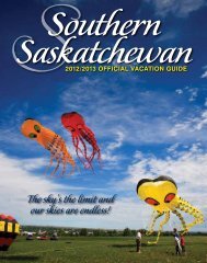
1-877-2ESCAPE | www.sasktourism.com<br />
To access online maps of <strong>Saskatchewan</strong> or to request a<br />
<strong>Saskatchewan</strong> Discovery Guide and Official Highway Map, visit:<br />
www.sasktourism.com/travel-information/travel-guides-and-maps<br />
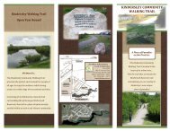
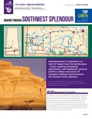
Hiking the <strong>Boreal</strong> <strong>Trail</strong><br />
Travel Itinerary | The <strong>Boreal</strong> <strong>Trail</strong><br />
Trip<br />
Length<br />
One week<br />
or less<br />
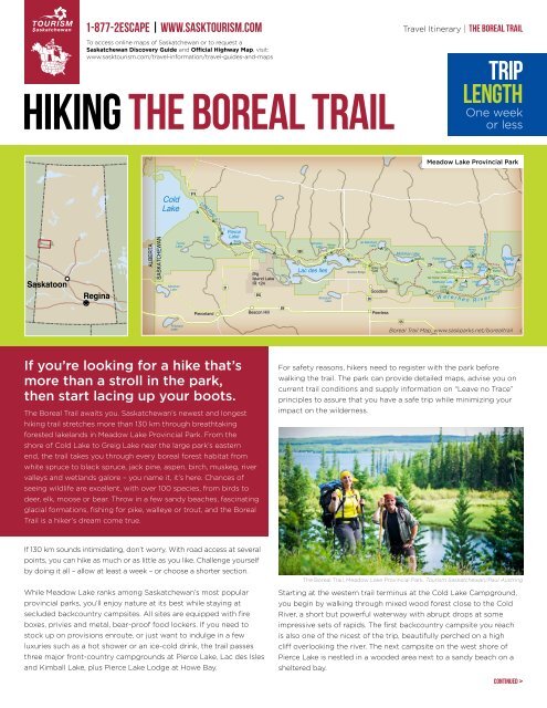
THE BOREAL TRAIL – MEADOW LAKE PROVINCIAL PARK<br />
Meadow Lake Provincial Park<br />
Cold<br />
Lake<br />
919<br />
Cold River<br />
BT 1<br />
Saskatoon<br />
Regina<br />
ALBERTA<br />
SASKATCHEWAN<br />
Pierce<br />
Lake<br />
If you’re looking for a hike that’s<br />
10 km<br />
more than a stroll in the park,<br />
then start lacing up your boots.<br />
The <strong>Boreal</strong> <strong>Trail</strong> awaits you. <strong>Saskatchewan</strong>’s newest and longest<br />
hiking trail stretches more than 130 km through breathtaking<br />
forested lakelands in Meadow Lake Provincial Park. From the<br />
shore of Cold Lake to Greig Lake near the large park’s eastern<br />
end, the trail takes you through every boreal forest habitat from<br />
white spruce to black spruce, jack pine, aspen, birch, muskeg, river<br />
valleys and wetlands galore – you name it, it’s here. Chances of<br />
seeing wildlife are excellent, with over 100 species, from birds to<br />
deer, elk, moose or bear. Throw in a few sandy beaches, fascinating<br />
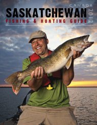
glacial formations, fishing for pike, walleye or trout, and the <strong>Boreal</strong><br />
<strong>Trail</strong> is a hiker’s dream come true.<br />
Meridian<br />
Lake<br />
Turvey<br />
Lake<br />
Pritchard<br />
Lake<br />
Hirtz<br />
Lake<br />
BT 2<br />
21<br />
Sandy<br />
Beach<br />
Lepine<br />
Lake<br />
Big<br />
Island Lake<br />
IR 124<br />
950<br />
BT 3<br />
Goodsoil<br />
26<br />
55<br />
Pierceland Beacon Hill Peerless<br />
<strong>Boreal</strong> <strong>Trail</strong> Distances<br />
<strong>Trail</strong> head (Cold River) to campsite BT 1<br />
Campsite BT 1 to campsite BT 2<br />
Campsite BT 2 to Sandy Beach campground<br />
Sandy Beach campground to Howe Bay<br />
Howe Bay to campsite BT 3<br />
Campsite BT 3 to campsite BT 4<br />
Campsite BT 4 to Murray Doell campground<br />
Murray Doell campground to campsite BT 5<br />
5.1 km<br />
4.1 km<br />
6.7 km<br />
8.2 km<br />
950<br />
Johnston<br />
Lake<br />
BT 4<br />
Lac des Iles<br />
Bousquet<br />
Lake<br />
Murray<br />
Doell<br />
BT 5<br />
Goodsoil Bridge<br />
Campsite BT 5 to De Balinard Lake<br />
Campsite BT 5 to Goodsoil Bridge<br />
Goodsoil Bridge to campsite BT 6<br />
Campsite BT 6 to Mistohay junction<br />
de Balinhard<br />
Lake<br />
Entry<br />
Gate<br />
DB<br />
Mistohay Lake<br />
Mistohay Peitahigan<br />
Lake<br />
224<br />
BT 6<br />
Matheson Lake<br />
Chalet<br />
BT 7<br />
Camp<br />
Greig<br />
Lake<br />
55<br />
<strong>Boreal</strong> <strong>Trail</strong> Map, www.saskparks.net/borealtrail<br />
9.7 km<br />
8.8 km<br />
10.4 km<br />
4.9 km<br />
For 8.7 kmsafety Mistohay reasons, junction to Mistohay hikers campground need 7.4 km to register First Mustus campground with to the trail end park before 9 km<br />
14 km Campsite BT 6 to campsite BT 7<br />
8.9 km New Branch junction to campsite BT 8<br />
3 walking 1.7 km Campsite the BT trail. 7 to Chalet The camp park can 5.6 provide km Campsite detailed BT 8 to campsite maps, BT 9 advise you 6.4 kmon<br />
9.2 km Chalet camp to Kimball (via river trail) 12.4 km Campsite BT 9 to trail end<br />
11.6 km<br />
current trail conditions and supply information on “Leave no Trace”<br />
principles to assure that you have a safe trip while minimizing your<br />
impact on the wilderness.<br />
W<br />
a t<br />
BT 8<br />
Vivian<br />
Lake<br />
e r h e n<br />
Fourth<br />
Mustus<br />
Lake<br />
BT 9<br />
Third<br />
Mustus<br />
Lake<br />
Kimball<br />
Lake<br />
R i v<br />
Dennis Creek<br />
First<br />
Mustus<br />
Lake<br />
e r<br />
North Route<br />
Chalet camp to Tall Timber <strong>Trail</strong>s<br />
Tall Timber <strong>Trail</strong>s to Third Mustus junction<br />
New Branch junction to Kimball Lake campgound<br />
Kimball Lake Campground to Fist Mustus campground<br />
First<br />
Mustus<br />
Kimball<br />
Lake<br />
Rusty<br />
Lake<br />
Little<br />
Raspberry Lake<br />
<strong>Trail</strong> end<br />
4.8 km<br />
1.6 km<br />
6.2 km<br />
2.3 km<br />
If 130 km sounds intimidating, don’t worry. With road access at several<br />
points, you can hike as much or as little as you like. Challenge yourself<br />
by doing it all – allow at least a week – or choose a shorter section.<br />
While Meadow Lake ranks among <strong>Saskatchewan</strong>’s most popular<br />
provincial parks, you’ll enjoy nature at its best while staying at<br />
secluded backcountry campsites. All sites are equipped with fire<br />
boxes, privies and metal, bear-proof food lockers. If you need to<br />
stock up on provisions enroute, or just want to indulge in a few<br />
luxuries such as a hot shower or an ice-cold drink, the trail passes<br />
three major front-country campgrounds at Pierce Lake, Lac des Isles<br />
and Kimball Lake, plus Pierce Lake Lodge at Howe Bay.<br />
The <strong>Boreal</strong> <strong>Trail</strong>, Meadow Lake Provincial Park. <strong>Tourism</strong> <strong>Saskatchewan</strong>/Paul Austring<br />
Starting at the western trail terminus at the Cold Lake Campground,<br />
you begin by walking through mixed wood forest close to the Cold<br />
River, a short but powerful waterway with abrupt drops at some<br />
impressive sets of rapids. The first backcountry campsite you reach<br />
is also one of the nicest of the trip, beautifully perched on a high<br />
cliff overlooking the river. The next campsite on the west shore of<br />
Pierce Lake is nestled in a wooded area next to a sandy beach on a<br />
sheltered bay.<br />
continued >
continued<br />
Travel Itinerary | The <strong>Boreal</strong> <strong>Trail</strong><br />
The trail follows the shore of Pierce Lake south to the large fullservice<br />
Sandy Beach Campground, then heads uphill through mostly<br />
aspen forest. For the next couple kilometres the <strong>Boreal</strong> <strong>Trail</strong> follows<br />
the same path as the Humphrey Lake <strong>Trail</strong>, a popular day hike from<br />
Sandy Beach Campground. This stretch tends to be rich in birdlife,<br />
especially near shallow Humphrey Lake which is favoured by loons,<br />
various waterfowl and occasionally tundra swans. Just a bit further<br />
up the hill, the trail comes to a height of land where you can climb<br />
a viewing tower for sweeping views of the forested lakelands.<br />
Not far past Lac des Isles, the terrain changes yet again as the trail<br />
follows the Waterhen River, the main waterway running through the<br />
park. The countryside becomes more open as the meandering river<br />
widens into wetlands rich in birds and other wildlife. Since there’s no<br />
road access for much of the way, you’ll enjoy parts of the park that<br />
few visitors ever see.<br />
Farther east the trail splits, offering three optional routes. Continue<br />
along the river and head up to Little Raspberry Lake, then Kimball<br />
Lake, site of the most popular beach in the park and the largest<br />
campground. Alternatively, turn north to Matheson and Vivian Lakes,<br />
then onto Kimball Lake. A third option is even better if you haven’t<br />
had enough of an “away from it all” experience. From Vivian Lake,<br />
turn north and circle around the four picture-perfect Mustus Lakes.<br />
First you hike along eskers near Third Mustus Lake, then to hilly terrain<br />
overlooking the creek between Third Mustus Lake and Peitahigan<br />
Lake. Watch for wildlife in the wide creek valley with adjoining<br />
wetlands – nesting grebes, terns, kingfishers, waterfowl and possibly<br />
coyote, wolf or moose. To continue on the <strong>Boreal</strong> <strong>Trail</strong> you must cross<br />
this creek, which is only feasible when water levels are not too high.<br />
The <strong>Boreal</strong> <strong>Trail</strong>, Meadow Lake Provincial Park. <strong>Tourism</strong> <strong>Saskatchewan</strong>/Paul Austring<br />
One of the prettiest sections is just north of Lac des Isles, among the<br />
park’s larger lakes. In addition to backcountry campsites, you can<br />
also overnight in the full-service Murray Doell Campground. But just<br />
before you arrive, you might run into a surprise left by busy beavers.<br />
They are fond of damming a creek here, which often means that the<br />
path gets flooded. You can cross the dam if it looks stable, but if in<br />
doubt, it’s not far to detour on the road.<br />
The stretch after Murray Doell is among the more challenging<br />
segments with several creek crossings. The trail heads inland from<br />
the lake to bypass a large wetland area formed by Sukaw Creek.<br />
Depending on water levels, you might be able to wade across the<br />
creek where the valley narrows or, if you prefer to keep your feet<br />
dry, continue a little farther to the road and cross the bridge. The<br />
east side of Sukaw Creek takes you through some of the most<br />
gorgeous landscapes of the entire trail, winding along the tops of<br />
eskers, looking over a mix of forest, meadows and wetlands with<br />
the expansive lake as a backdrop. Arriving back at Lac des Isles, you<br />
can relax on your own private beach at yet another nicely situated<br />
backcountry campsite.<br />
In the next couple kilometres you have to contend with a troublesome<br />
water crossing where a creek empties into the lake. No matter<br />
how you look at it, you’re going to get wet! Sometimes it’s a simple<br />
matter of wading across, but more often than not you’ll find deep<br />
channels excavated by beavers. If you’re looking for another way<br />
through, sometimes the best bet is to wade into the lake.<br />
On the east side of First Mustus Lake, the two branches of the <strong>Boreal</strong><br />
<strong>Trail</strong> meet for the final leg to trail’s end at Greig Lake. Now it’s time<br />
to kick off the hiking boots, relax and celebrate. You’ve accomplished<br />
the <strong>Boreal</strong> <strong>Trail</strong> – <strong>Saskatchewan</strong>’s longest hike.<br />
Contacts and resources<br />
<strong>Boreal</strong> <strong>Trail</strong> Map – <strong>Saskatchewan</strong> Parks<br />
W: http://saskparks.net/borealtrail<br />
Meadow Lake Provincial Park<br />
5 km N of Goodsoil on Hwy 26, 24 km N of Pierceland on Hwy 21,<br />
6 km N of Dorintosh on Hwy 4<br />
P: 306-236-7680 TF: 1-800-205-7070 W: www.2sk.ca/13383<br />
Meadow Lake<br />
Information on accommodations, attractions, shopping and dining<br />
P: 306-236-3622 W: www.2sk.ca/com/1000584<br />
Pierce Lake Lodge<br />
South shore of Howe Bay at Pierce Lake in Meadow Lake<br />
Provincial Park<br />
Open: year-round<br />
P: 306-839-4517 W: www.2sk.ca/14669<br />
An $11 per-tent, per-night camping fee is charged for the use of<br />
backcountry campsites. Fees can be paid at the point of registration.<br />
You’re encouraged to contact Meadow Lake Provincial Park before<br />
visiting to inquire about any trail closures and suggested places to<br />
leave a vehicle. P: 306-236-7680 or E: meadowlake@gov.sk.ca<br />
Disclaimer: <strong>Tourism</strong> <strong>Saskatchewan</strong> makes every effort to ensure the accuracy of information contained in this travel itinerary. Please note, all services, accommodations,<br />
attractions and events are subject to change without notice. For more information, please contact <strong>Tourism</strong> <strong>Saskatchewan</strong> at 1-877-2ESCAPE or www.2sk.ca.