Driving Southwest Splendour - Tourism Saskatchewan
Driving Southwest Splendour - Tourism Saskatchewan
Driving Southwest Splendour - Tourism Saskatchewan

You also want an ePaper? Increase the reach of your titles
YUMPU automatically turns print PDFs into web optimized ePapers that Google loves.
Saskatoon<br />
1-877-2ESCAPE | www.sasktourism.com<br />
To access online maps of <strong>Saskatchewan</strong> or to request a<br />
<strong>Saskatchewan</strong> Discovery Guide and Official Highway Map, visit:<br />
www.sasktourism.com/travel-information/travel-guides-and-maps<br />
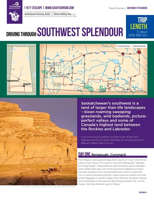
southwest splendour<br />
Regina<br />
driving through<br />
Travel Itinerary | southwest splendour<br />
Trip<br />
Length<br />
5 days<br />
838-881 km<br />
•<br />
Itinerary Route<br />
•<br />
Alternate Route<br />
Regina<br />
Swift Current<br />
1<br />
1<br />
Moose Jaw<br />
6<br />
ALBERTA<br />
1<br />
Cypress Hills<br />
Winery<br />
271<br />
21<br />
Maple Creek<br />
37<br />
4<br />
2<br />
Saskatoon<br />
Regina<br />
Fort Walsh<br />
National<br />
Historic Site<br />
SASKATCHEWAN<br />
Gap<br />
Road<br />
Davis Creek<br />
Cypress Hills<br />
Road<br />
Interprovincial<br />
Ravenscrag 13<br />
Park<br />
Road<br />
Ravenscrag<br />
Eastend<br />
Old Man on His Back<br />
Prairie & Heritage<br />
Conservation Area<br />
Claydon<br />
18<br />
37<br />
Shaunavon<br />
CANADA<br />
Val Marie<br />
Grasslands National Park<br />
(West Block)<br />
Grasslands National Park<br />
(East Block)<br />
UNITED STATES OF AMERICA<br />
Assiniboia<br />
Wood Mountain<br />
Wood Mountain<br />
Regional Park<br />
18 Rockglen<br />
2<br />
Killdeer<br />
Coronach<br />
Castle Butte<br />
18<br />
34<br />
Bengough<br />
Big<br />
Big<br />
Beaver<br />
13<br />
Big Muddy Lake<br />
Muddy<br />
Badlands<br />
<strong>Saskatchewan</strong>’s southwest is a<br />
land of larger than life landscapes<br />
– bison roaming sweeping<br />
grasslands, wild badlands, pictureperfect<br />
valleys and some of<br />
Canada’s highest land between<br />
the Rockies and Labrador.<br />
If you’re the kind of explorer who likes to get off the major Swift Current<br />
highways and into the scenic heartland, this five-day drive from<br />
Regina to Maple Creek is for you.<br />
ALBERTA<br />
Fort Walsh<br />
National<br />
Historic Site<br />
Castle Butte, Big Muddy Badlands. <strong>Tourism</strong> <strong>Saskatchewan</strong>/Paul Austring<br />
EWAN<br />
DAY ONE Bengough, Coronach<br />
1<br />
From Regina, travel approximately 85 km south on Hwy 6, then 40 km<br />
Cypress Hills west on Hwy<br />
Maple<br />
13<br />
Creek<br />
and 17 km south on Hwy 34 to Bengough, “Gateway<br />
Winery to the Big Muddy.” These badlands were formed by glacial meltwater<br />
some 15,000 years ago, with continuing erosion<br />
37<br />
deepening incised<br />
271 21<br />
channels, revealing multi-coloured sediments millions of years old.<br />
This is a land of sprawling ranches, where notorious outlaws once had<br />
Gap<br />
Road<br />
Davis Creek<br />
Cypress secret Hills hideaways in remote coulees. Most infamous was Butch Cassidy<br />
Road<br />
Shaunavon<br />
Interprovincial and the Wild Bunch who Ravenscrag used the Big 13Muddy as Station No. 1 on the<br />
Park Outlaw Trail that stretched Road south to Mexico.<br />
Ravenscrag<br />
Eastend<br />
37<br />
continued ><br />
4
Travel Itinerary | southwest splendour<br />
Grasslands National Park of Canada. <strong>Tourism</strong> <strong>Saskatchewan</strong>/Greg Huszar Photography<br />
<strong>Driving</strong> south of Bengough you suddenly drop into the wide scenic<br />
valley. Follow the road running west along the valley floor to Big<br />
Muddy’s iconic landmark – Castle Butte. The weathered slopes of this<br />
60-metre high monolith are impressive anytime, but become magical<br />
at sunrise or sunset when bathed in the sun’s brilliant reddish-orange<br />
glow. Castle Butte is located 22 km south of Bengough on Hwy 34 and<br />
5 km west on a grid road. Watch for the sign at the grid turn-off.<br />
Return to Hwy 34 and continue 13 km south, then turn west on Hwy 18<br />
for a couple of kilometres to Big Beaver, a tiny community that’s home<br />
to famous Aust’s General Store; its motto says it all – “If we don’t have<br />
it, you don’t need it.”<br />
Travel nearly 29 km west on Hwy 18 to Coronach. The nearby Poplar<br />
River Power Plant and Mine Site generates a third of <strong>Saskatchewan</strong>’s<br />
electricity. Join a tour of the power plant and coal mines where<br />
gigantic drag-lines expose the rich deposits. Tours originate from<br />
220 Centre Street in Coronach. Coronach’s highlight is a trip with<br />
Big Muddy Tours where you really get up close and personal with<br />
the badlands, from wild landscapes to outlaw caves and ancient<br />
aboriginal stone effigies. Please call ahead to pre-book your trip<br />
with Big Muddy Tours.<br />
Overnight in Coronach or continue on to Rockglen, the first stop on<br />
your itinerary tomorrow.<br />
DAY two Rockglen, Grasslands National Park, Val Marie<br />
Continue 36 km west on Hwy 18 to Rockglen. The community is<br />
nestled in the scenic Wood Mountain Uplands, which are one of<br />
only four areas in North America untouched by the last glaciations.<br />
Opportunities abound to explore the area’s ecological, geological and<br />
cultural history. Visit the Effie Mattson Nature Walk and Archaeological<br />
Centre or stretch your legs on the Yost Wildlife Hike, located just<br />
outside town along Hwy 2, a preserved natural area with spectacular<br />
views over the town and surrounding hills.<br />
Travel for 35 km west on Hwy 2 to Killdeer. From Killdeer head north<br />
on Hwy 18 for a short distance and follow signage to the East Block<br />
of Grasslands National Park, protecting one of the largest and least<br />
disturbed tracts of native prairie in North America. Off Hwy 18 you<br />
will travel on gravel roads 6.4 km west, then 6.4 km south and another<br />
2.4 km west to the main road access for the East Block and the<br />
former “McGowan Place” next to Rock Creek, now a picnic site and<br />
campground. Several suggested hikes begin here and lead you to<br />
rugged hills, badlands and picturesque valleys.<br />
Follow the road signs a few kilometres south to Poverty Ridge Warden<br />
Station. A minor road behind the house and yard runs 3 km west to<br />
the park boundary where an easy walk along the valley rim reveals<br />
spectacular views over the Killdeer Badlands. Here the plateau dips<br />
sharply into multi-coloured gullied slopes with free-standing buttes<br />
and whimsically sculpted formations. Killdeer Badlands was the site<br />
of western Canada’s first discovery of dinosaur bones in 1874 by the<br />
Boundary Commission.<br />
Follow the signage to Grassland National Park’s West Block by<br />
returning to Hwy 18 and travelling 30 km north to Wood Mountain,<br />
then 126 km west along Hwy 18 to Val Marie. A worthwhile sidetrip<br />
along Hwy 18 is the Wood Mountain Regional Park, where the Wood<br />
Mountain Rodeo Ranch Museum acts as a summer information centre<br />
for the national park. Located in Val Marie, the Grasslands National<br />
Park Visitor Centre houses displays on this special environment and<br />
provides helpful information on drives, hikes and park programs.<br />
The 80 km Ecotour drive through the West Block highlights is not-tobe-missed.<br />
The well-signed route leads east on Hwy 18, then south into<br />
the Frenchman River Valley where the landscape suddenly opens up<br />
into sweeping views of the picturesque valley floor along the narrow<br />
river, framed by weathered buttes and scenic hills. Rich in wildlife, you<br />
may see pronghorn, mule deer or perhaps the free-ranging bison that<br />
roam the park. Watch for prairie rattlesnakes along the road and look<br />
up for a glimpse of the threatened ferruginous hawk. This valley is the<br />
only place in Canada to see black-tailed prairie dogs, noisily chirping
Travel Itinerary | southwest splendour<br />
away in sprawling colonies right beside the road. The loop tour returns<br />
to Val Marie from the south, passing by the park’s highest point of land<br />
and most imposing site – 70 Mile Butte.<br />
After a full day of exploration, retire in one of Val Marie’s excellent<br />
accommodations including the Convent Country Inn, The Crossing<br />
Resort, Rosefield Church Guesthouse and Ride with Lamotte.<br />
DAY three Eastend<br />
Travel approximately 95 km west along Hwy 18 to Claydon. At the<br />
corner where Hwy 18 curves south, continue west to Old Man on<br />
His Back Prairie and Heritage Conservation Area. The former ranch<br />
of Peter and Sharon Butala, now run by the Nature Conservancy of<br />
Canada, protects this vast and rare stretch of native prairie with its<br />
abundant wildflowers, grassland birds and broad vistas. Among the<br />
wildlife are plains bison that roam freely as they did for thousands<br />
of years. The visitor centre operates on weekends from May to<br />
September. For weekday access, please call ahead (see Contacts<br />
and Resources).<br />
Return to Claydon and take the grid road that runs north, meeting<br />
Hwy 13 just southwest of Eastend, a beautifully situated valley town<br />
boasting more than its fair share of scenic spots. The drive from<br />
Claydon to Eastend is approximately 60 km. Hiking and driving tours<br />
can be downloaded from the Eastend website from a link provided<br />
at the end of this itinerary, and include picturesque sights like Jones<br />
Peak, Chimney Coulee, Brady Coulee and Pine Cree Regional Park.<br />
A highlight is Eastend’s T. rex Centre, a combination visitor centre<br />
and research facility conducting work on the area’s numerous<br />
paleontological finds including Scotty, Canada’s most complete<br />
Tyrannosaurus rex skeleton. Fixed-roof accommodations and camping<br />
are available in Eastend, so take the evening to soak in the beauty of<br />
the Frenchman River Valley.<br />
DAY four Cypress Hills Interprovincial Park<br />
Head west of Eastend on Grid 614 for 2 km, then turn left onto<br />
Ravenscrag Road. The next 22 km follows the meandering Frenchman<br />
River framed by spectacular multi-coloured badland-like slopes, many<br />
with a striking band of brilliant white sandstone.<br />
The park has plenty of amenities to keep you as busy as you would<br />
like including zipline canopy tours by Cypress Hills Eco-Adventures,<br />
an outdoor swimming pool, boat rentals on Loch Leven, Cypress Hills<br />
Golf Course, mini-golf, tennis courts, Cypress Hills Riding Academy and<br />
nature trails galore.<br />
The Centre Block will be your home for the evening. Choose from<br />
cabins, condos and hotel rooms at the Cypress Park Resort Inn or<br />
camp in one of the park’s campgrounds.<br />
DAY five Cypress Hills Interprovincial Park, Maple Creek<br />
Take the Gap Road, a 32 km shortcut across pastureland to the<br />
park’s West Block Wilderness Area. The road could be rough, even<br />
impassable after a rain, but the “see forever” views make it worthwhile.<br />
Please check with park officials for current road conditions. If road<br />
conditions are poor, you can reach the West Block by travelling 27 km<br />
north to Maple Creek on Hwy 21, then 50 km southwest on Hwy 271.<br />
Approaching the West Block Wilderness Area, you climb a series of<br />
switchbacks to the plateau. Along this road is the approach to Fort<br />
Walsh, a national historic site reliving the early days of the North West<br />
Mounted Police. Just west is the turnoff to the conglomerate cliffs,<br />
a must-visit where the edge of the escarpment consists of cliffs of<br />
water-worn cobblestones that have been naturally cemented together,<br />
with outstanding views over Adams Lake and the plains and hills<br />
below. Further into the West Block, the road descends into Battle<br />
Creek Valley and follows this picture-perfect creek as it meanders<br />
through the park.<br />
To finish your route, return to Hwy 271 for the scenic 50 km drive to<br />
Maple Creek, which is just south of Trans Canada Hwy 1 and a much<br />
quicker route back to Regina. The Cypress Hills Vineyard & Winery is<br />
located just off Hwy 271 en-route to Maple Creek (watch for signs).<br />
If time allows, cap off your visit to <strong>Saskatchewan</strong>’s southwest with a<br />
tasting of their wines made from <strong>Saskatchewan</strong>-grown fruits, a slice<br />
of saskatoon pie and a gourmet sandwich or artisan cheese platter.<br />
At Ravenscrag, head north for 7 km, then west along Davis Creek Road<br />
to Hwy 21. From this corner it’s only 12 km north to the Centre Block<br />
of Cypress Hills Interprovincial Park where the terrain changes yet<br />
again. These hills have a flavour all their own with highlands of white<br />
spruce and lodgepole pine more reminiscent of the north or mountain<br />
foothills, combining with open grasslands and wetlands. The mix of<br />
landscapes makes it especially rich in wildlife with plenty of moose, elk,<br />
pronghorn, over 200 species of birds and stunning wildflower displays.<br />
Head to the visitor centre for information on drives, hikes and other<br />
activities, then explore the Centre Block along the auto tour that takes<br />
you to Lookout Point on the edge of the escarpment to gaze over the<br />
plains far below, and Bald Butte, where you can walk the short path up<br />
this treeless hill marking the highest point in the block.<br />
Cypress Hills Interprovincial Park. <strong>Tourism</strong> <strong>Saskatchewan</strong>/Greg Huszar Photography
continued<br />
Travel Itinerary | southwest splendour<br />
Contacts and resources<br />
Coronach<br />
Information on accommodations,<br />
attractions and services<br />
P: 306-267-3312<br />
W: www.2sk.ca/com/1000184<br />
Big Muddy/Outlaw Cave Tours<br />
Depart from Coronach Golf Course, watch<br />
for signs<br />
Open: June-Sep, call ahead for availability<br />
P: 306-267-3312<br />
W: www.2sk.ca/9504<br />
Poplar River Power Plant and Mine Site<br />
Tours depart from 220 Centre St, Coronach<br />
Open: Mar-Dec, call ahead to pre-book<br />
P: 306-267-2078 / 306-267-2157<br />
W: www.2sk.ca/14566<br />
Rockglen<br />
Information on accommodations,<br />
attractions and services<br />
P: 306- 476-2144<br />
W: www.2sk.ca/com/1000768<br />
Rockglen and District Visitor Centre<br />
Junction of Hwys 2 and 18, Rockglen<br />
Open: late May-Sep, call ahead for<br />
seasonal hours<br />
P: 306-476-2002 / 306-476-2144<br />
W: www.2sk.ca/9324<br />
Wood Mountain Rodeo Ranch Museum<br />
Wood Mountain Regional Park, 8 km S of<br />
Wood Mountain<br />
Information on the East Block of<br />
Grasslands National Park<br />
Open: May – Sep, call ahead for<br />
seasonal hours<br />
P: 306-266-4953<br />
W: www.2sk.ca/10279<br />
Val Marie<br />
Information on accommodations,<br />
attractions and services<br />
P: 306-298-2022<br />
W: www.2sk.ca/com/1000926<br />
Grasslands National Park of Canada<br />
SW <strong>Saskatchewan</strong> between Val Marie<br />
and Killdeer, S of Hwy 18<br />
Park Visitor Centre located in Val Marie,<br />
call ahead for seasonal hours<br />
Open: year-round<br />
P: 306-298-2257<br />
W: www.2sk.ca/14659<br />
Eastend<br />
Town Office, 108 Maple Street<br />
Information on accommodations,<br />
attractions and services<br />
P: 306-295-3322 / 306-295-3553<br />
W: www.2sk.ca/com/1000247<br />
Eastend <strong>Driving</strong> and Hiking Tours<br />
W: www.dinocountry.com<br />
T. rex Discovery Centre<br />
1 km N of Eastend<br />
Open: year-round, call ahead for<br />
seasonal hours<br />
P: 306-295-4009 / 306-295-4734<br />
W: www.2sk.ca/13806<br />
Eastend Museum – Cultural Centre<br />
306 Red Coat Dr, Eastend<br />
Open: late-May-Sep, call ahead for<br />
seasonal hours<br />
P: 306-295-3375 / 306-295-3564<br />
W: www.2sk.ca/12880<br />
Old Man on His Back Visitor Centre<br />
60 km SW of Eastend via Hwy 13 and<br />
Claydon Grid<br />
Open: weekends, May long-weekend to<br />
mid-Sep, call ahead for weekday access<br />
P: 306-296-2077 / 306-347-0447<br />
TF: 1-866-622-7275<br />
W: www.2sk.ca/20152<br />
Cypress Hills <strong>Tourism</strong> Destination Area<br />
W: www.cypresshills.ca<br />
Cypress Hills Interprovincial Park<br />
Centre Block (full services), 27 km S of<br />
Maple Creek on Hwy 21<br />
West Block Wilderness Area (limited<br />
services), 57 km SW of Maple Creek<br />
on Hwy 271<br />
Open: year-round<br />
P: 306-662-5411 TF: 1-800-205-7070<br />
W: www.2sk.ca/11231<br />
Cypress Park Resort Inn and<br />
Ivan’s Restaurant<br />
30 km S of Maple Creek in Cypress Hills<br />
Interprovincial Park<br />
Hotel rooms, cabins and condominiums,<br />
licensed dining<br />
Open: year-round<br />
P: 306-662-12853<br />
W: www.2sk.ca/12853<br />
Cypress Hills Eco-Adventures Ltd.<br />
Cypress Hills Interprovincial Park –<br />
Centre Block<br />
Open: May-Oct<br />
P: 306-716-6541<br />
W: www.2sk.ca/23198<br />
Fort Walsh National Historic Site<br />
55 km SW of Maple Creek on Hwy 271<br />
Open: May – Sep, call ahead for<br />
seasonal hours<br />
P: 306-662-2645 / 306-662-3590<br />
W: www.2sk.ca/14548<br />
Cypress Hills Vineyard & Winery<br />
20 km SW of Maple Creek on Hwy 271<br />
Open: May – Oct, call ahead for hours<br />
and food service availability<br />
P: 306-662-4100<br />
W: www.2sk.ca/21407<br />
Maple Creek Information Centre<br />
114 Jasper St<br />
Information on accommodations,<br />
attractions, shopping and dining<br />
Open: year-round, call ahead for<br />
seasonal hours<br />
P: 306-662-4005 / 306-662-2244<br />
W: www.2sk.ca/com/1000555<br />
Jasper Cultural and Historical Centre<br />
311 Jasper St, Maple Creek<br />
Open: year-round, call ahead for<br />
seasonal hours<br />
P: 306-662-2434 / 306-662-2876<br />
W: www.2sk.ca/16719<br />
<strong>Southwest</strong> <strong>Saskatchewan</strong><br />
Old-Timer’s Museum<br />
218 Jasper St, Maple Creek<br />
Open: May-Sep, other times<br />
by appointment<br />
P: 306-662-2474<br />
W: www.2sk.ca/14499<br />
special events<br />
Bengough:<br />
The Gateway Festival, July –<br />
www.2sk.ca/21163<br />
Grasslands National Park:<br />
East Block Party, Aug -<br />
www.2sk.ca/14659<br />
Astronomy Program, Friday evenings,<br />
May-Sep -<br />
www.2sk.ca/14659<br />
Cypress Hills <strong>Tourism</strong> Destination Area:<br />
<strong>Saskatchewan</strong> Summer Star Party, Aug –<br />
www.2sk.ca/17082<br />
South West Quest for <strong>Saskatchewan</strong> Art<br />
and History, July –<br />
www.2sk.ca/18661<br />
Maple Creek:<br />
Maple Creek Cowtown Rodeo, July –<br />
www.2sk.ca/10167<br />
Cowboy Poetry Gathering and Western<br />
Art & Cowboy Gear Show, Sep –<br />
www.2sk.ca/10172<br />
Disclaimer: <strong>Tourism</strong> <strong>Saskatchewan</strong> makes every effort to ensure the accuracy of information contained in this travel itinerary. Please note, all services, accommodations,<br />
attractions and events are subject to change without notice. For more information, please contact <strong>Tourism</strong> <strong>Saskatchewan</strong> at 1-877-2ESCAPE or www.2sk.ca.