Driving Southwest Splendour - Tourism Saskatchewan
Driving Southwest Splendour - Tourism Saskatchewan
Driving Southwest Splendour - Tourism Saskatchewan

You also want an ePaper? Increase the reach of your titles
YUMPU automatically turns print PDFs into web optimized ePapers that Google loves.
Travel Itinerary | southwest splendour<br />
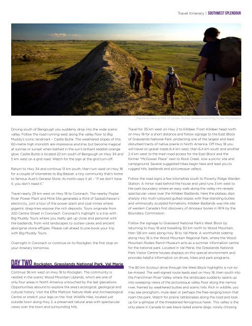
Grasslands National Park of Canada. <strong>Tourism</strong> <strong>Saskatchewan</strong>/Greg Huszar Photography<br />
<strong>Driving</strong> south of Bengough you suddenly drop into the wide scenic<br />
valley. Follow the road running west along the valley floor to Big<br />
Muddy’s iconic landmark – Castle Butte. The weathered slopes of this<br />
60-metre high monolith are impressive anytime, but become magical<br />
at sunrise or sunset when bathed in the sun’s brilliant reddish-orange<br />
glow. Castle Butte is located 22 km south of Bengough on Hwy 34 and<br />
5 km west on a grid road. Watch for the sign at the grid turn-off.<br />
Return to Hwy 34 and continue 13 km south, then turn west on Hwy 18<br />
for a couple of kilometres to Big Beaver, a tiny community that’s home<br />
to famous Aust’s General Store; its motto says it all – “If we don’t have<br />
it, you don’t need it.”<br />
Travel nearly 29 km west on Hwy 18 to Coronach. The nearby Poplar<br />
River Power Plant and Mine Site generates a third of <strong>Saskatchewan</strong>’s<br />
electricity. Join a tour of the power plant and coal mines where<br />
gigantic drag-lines expose the rich deposits. Tours originate from<br />
220 Centre Street in Coronach. Coronach’s highlight is a trip with<br />
Big Muddy Tours where you really get up close and personal with<br />
the badlands, from wild landscapes to outlaw caves and ancient<br />
aboriginal stone effigies. Please call ahead to pre-book your trip<br />
with Big Muddy Tours.<br />
Overnight in Coronach or continue on to Rockglen, the first stop on<br />
your itinerary tomorrow.<br />
DAY two Rockglen, Grasslands National Park, Val Marie<br />
Continue 36 km west on Hwy 18 to Rockglen. The community is<br />
nestled in the scenic Wood Mountain Uplands, which are one of<br />
only four areas in North America untouched by the last glaciations.<br />
Opportunities abound to explore the area’s ecological, geological and<br />
cultural history. Visit the Effie Mattson Nature Walk and Archaeological<br />
Centre or stretch your legs on the Yost Wildlife Hike, located just<br />
outside town along Hwy 2, a preserved natural area with spectacular<br />
views over the town and surrounding hills.<br />
Travel for 35 km west on Hwy 2 to Killdeer. From Killdeer head north<br />
on Hwy 18 for a short distance and follow signage to the East Block<br />
of Grasslands National Park, protecting one of the largest and least<br />
disturbed tracts of native prairie in North America. Off Hwy 18 you<br />
will travel on gravel roads 6.4 km west, then 6.4 km south and another<br />
2.4 km west to the main road access for the East Block and the<br />
former “McGowan Place” next to Rock Creek, now a picnic site and<br />
campground. Several suggested hikes begin here and lead you to<br />
rugged hills, badlands and picturesque valleys.<br />
Follow the road signs a few kilometres south to Poverty Ridge Warden<br />
Station. A minor road behind the house and yard runs 3 km west to<br />
the park boundary where an easy walk along the valley rim reveals<br />
spectacular views over the Killdeer Badlands. Here the plateau dips<br />
sharply into multi-coloured gullied slopes with free-standing buttes<br />
and whimsically sculpted formations. Killdeer Badlands was the site<br />
of western Canada’s first discovery of dinosaur bones in 1874 by the<br />
Boundary Commission.<br />
Follow the signage to Grassland National Park’s West Block by<br />
returning to Hwy 18 and travelling 30 km north to Wood Mountain,<br />
then 126 km west along Hwy 18 to Val Marie. A worthwhile sidetrip<br />
along Hwy 18 is the Wood Mountain Regional Park, where the Wood<br />
Mountain Rodeo Ranch Museum acts as a summer information centre<br />
for the national park. Located in Val Marie, the Grasslands National<br />
Park Visitor Centre houses displays on this special environment and<br />
provides helpful information on drives, hikes and park programs.<br />
The 80 km Ecotour drive through the West Block highlights is not-tobe-missed.<br />
The well-signed route leads east on Hwy 18, then south into<br />
the Frenchman River Valley where the landscape suddenly opens up<br />
into sweeping views of the picturesque valley floor along the narrow<br />
river, framed by weathered buttes and scenic hills. Rich in wildlife, you<br />
may see pronghorn, mule deer or perhaps the free-ranging bison that<br />
roam the park. Watch for prairie rattlesnakes along the road and look<br />
up for a glimpse of the threatened ferruginous hawk. This valley is the<br />
only place in Canada to see black-tailed prairie dogs, noisily chirping