SEG - Society of Economic Geologists
SEG - Society of Economic Geologists
SEG - Society of Economic Geologists

Create successful ePaper yourself
Turn your PDF publications into a flip-book with our unique Google optimized e-Paper software.
12 <strong>SEG</strong> NEWSLETTER No 91 • OCTOBER 2012<br />
... from 11<br />
Mauritania: A Greenfields Exploration Opportunity in Northwestern Africa (Continued)<br />
into production in 2007, is located in<br />
the southwestern corner <strong>of</strong> the Rgueïbat<br />
Shield and is a world-class Paleoprotero -<br />
zoic(?) orogenic gold deposit. The producing<br />
Guelb Moghrein deposit occurs<br />
along a shear zone in Middle Archean<br />
rocks at the bend in the northern<br />
Mauritanides and is most commonly<br />
classified as an IOCG type <strong>of</strong> deposit<br />
(see next section). Both major deposits<br />
are surrounded by numerous prospects<br />
that show similar mineralization styles.<br />
Most <strong>of</strong> the Mesoarchean and<br />
Paleoproterozoic rocks <strong>of</strong> the Rgueïbat<br />
Shield in northern Mauritania are highgrade<br />
gneisses (e.g., Key et al., 2008;<br />
Sch<strong>of</strong>ield et al., 2012), which are not<br />
favorable for gold resources. However,<br />
the metamorphic grade in the shield<br />
appears to decrease to more favorable<br />
greenschist facies to the east and defines<br />
an area with potential for orogenic gold<br />
deposits in Paleoproterozoic rocks. A few<br />
small gold prospects (e.g., Conchita-<br />
Florence or Nsour, El Mheissat, Oued El<br />
Ma, and Bin-652), now being explored<br />
by Drake Resources Limited (Drake<br />
Resources Limited, 2012), are recognized<br />
north <strong>of</strong> latitude 21 o N, a region<br />
that includes most outcrops <strong>of</strong> ca. 2.1<br />
Ga Birimian rocks <strong>of</strong> the shield. Drake<br />
Resources Limited reports high-grade<br />
gold samples at Conchita-Florence,<br />
adjacent to a 140-km-long shear zone<br />
system <strong>of</strong> anomalous gold termed the<br />
Hendrix shear zone. This zone also represents<br />
the only distinct belt <strong>of</strong> volcaniclastic<br />
rocks defined to date in the eastern<br />
part <strong>of</strong> the shield (e.g., Bradley et<br />
al., in press a). The high gold samples<br />
also have anomalous concentrations <strong>of</strong><br />
Ag, Au, Mo, Sb, Te, and W, and are<br />
associated with outcropping gold-bearing<br />
quartz veins in greenschist facies<br />
metapelites. Several 40 Ar/ 39 Ar dates on<br />
hydrothermal sericite from prospects to<br />
the southeast along this trend (Bradley<br />
et al., in press b) suggest that these<br />
prospects are Paleoproterozoic in age.<br />
Further assessment <strong>of</strong> the region will<br />
require detailed geochemical maps, re -<br />
gional metamorphic maps, and evaluation<br />
<strong>of</strong> existing regional structure. If<br />
permissive areas exist for important gold<br />
resources in the Rgueïbat Shield, then<br />
such areas are likely to be broadly<br />
defined as those <strong>of</strong> relatively low metamorphic<br />
grade, mainly <strong>of</strong> greenschist<br />
facies. They will likely be newly recognized<br />
metasedimentary rock belts similar<br />
to those that host the Conchita-Florence<br />
occurrences. These favorable areas would<br />
include rocks <strong>of</strong> the Lower and Upper<br />
Birimian supracrustal rocks that are<br />
located east <strong>of</strong> the Zednes fault zone. In<br />
addition, the relatively NNW-trending<br />
major faults cutting the eastern half <strong>of</strong><br />
the shield are likely to be particularly<br />
permissive hosts for gold ores where<br />
present in lower grade metamorphic<br />
domains; margins <strong>of</strong> igneous rocks<br />
shown along some <strong>of</strong> these faults in any<br />
lower grade exposures should be carefully<br />
examined (Goldfarb et al., in press).<br />
The far southwestern corner <strong>of</strong> the<br />
Rgueïbat Shield (lat. 20°–21° and long.<br />
14°–16°) is the one area in the Meso -<br />
archean part <strong>of</strong> the shield with greenschist<br />
facies greenstone belts; the seven<br />
defined belts (Bradley et al., in press a)<br />
trend N-S in the west (e.g., Chami) and<br />
NE-SW in the east (e.g., Tirijit). The<br />
greenstone belts are exposed in the<br />
southern part <strong>of</strong> the Tasiast-Tijirit terrane<br />
<strong>of</strong> Sch<strong>of</strong>ield et al. (2012). They are<br />
located within a basement <strong>of</strong> ca.<br />
3.1–3.0 Ga migmatitic gneisses that<br />
were metamorphosed at ca. 2.97 Ga;<br />
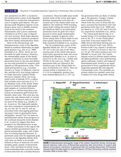
0 20000 m<br />
Mapped BIF<br />
Rusty<br />
Aoueouat<br />
Chami<br />
Tasiast<br />
C-23<br />
N’Derek<br />
the greenstone belts are likely <strong>of</strong> similar<br />
age to the gneisses. Younger, voluminous<br />
tonalities and granodiorites,<br />
which form the cores <strong>of</strong> dome-like features,<br />
surround the basement rocks and<br />
greenstone belts (Key et al., 2008) and<br />
are dated at ca. 2.95–2.87 and 2.69–2.65<br />
Ga, respectively (Sch<strong>of</strong>ield et al., 2012).<br />
The Tasiast gold deposit (Fig. 3) is<br />
located along a N-S–trending shear system<br />
in the 70 × 15 km Chami greenstone<br />
belt. It has been mined since<br />
2008, first by Red Back Mining and currently<br />
by Kinross Gold Corp. (2012).<br />
Kinross Gold Corp. reports a world-class<br />
reserve + resource <strong>of</strong> at least 21 Moz Au<br />
at 1.47 g/t. The mine produces just over<br />
200,000 oz Au per year. The Tasiast<br />
deposit occurs as sheeted quartz-carbonate-albite-pyrrhotite<br />
veins, gold-bearing<br />
quartz-carbonate veinlets, and adjacent<br />
disseminated gold, hosted in an upper<br />
greenschist to lower amphibolite facies,<br />
magnetite-quartzite BIF and adjacent<br />
volcaniclastic rocks. The orebodies are<br />
present within two parallel zones that<br />
continue for 6 km along strike (Davis,<br />
Mapped Greenstone<br />
Belt<br />
Jurassic dikes<br />
Mesoarchean (?) dike<br />
Gold prospect<br />
Tijirit<br />
FIGURE 3. Reduced-to-pole aeromagnetic image <strong>of</strong> the southern Tasiast-Tijirit terrane, showing geophysical<br />
extensions under cover <strong>of</strong> Mesoarchean greenstone belts and locations <strong>of</strong> orogenic gold<br />
deposits and prospects. Intersections <strong>of</strong> greenstone belts and possible Mesoarchean (?) lineaments<br />
represent highly favorable targets for additional deposits. All linear NE-trending moderate amplitude<br />
anomalies relate to Jurassic dikes.