A True Test of Sustainability
A True Test of Sustainability
A True Test of Sustainability

Create successful ePaper yourself
Turn your PDF publications into a flip-book with our unique Google optimized e-Paper software.
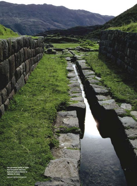
The perennial spring <strong>of</strong> Tipon<br />
was formalized with Inca<br />
hydraulic enhancements to<br />
optimize its yield.<br />
Wright Water Engineers<br />
78 W E & T • w w w. w e f. o r g / m a g a z i n e © 2008 Water Environment & Technology All rights reserved
A <strong>True</strong> <strong>Test</strong> <strong>of</strong><br />
<strong>Sustainability</strong><br />
The triumph <strong>of</strong> Incan civil engineering over<br />
scarce water resources survives today<br />
Kenneth R. Wright<br />
Inca water planning, management,<br />
and construction <strong>of</strong> water facilities<br />
were as varied as the Peruvian landscape.<br />
Decadelong field studies at the<br />
pre-Columbian archaeological sites <strong>of</strong><br />
Machu Picchu, Moray, and Tipon have<br />
revealed that the Incas possessed an<br />
uncanny ability to develop water resources on<br />
a site-specific basis. This remarkable knowledge<br />
<strong>of</strong> water resources development principles occurred<br />
without a written language, use <strong>of</strong> the<br />
wheel, or the availability <strong>of</strong> iron or steel.<br />
The author has had the privilege <strong>of</strong> studying<br />
ancient water use and handling, or paleohydrology,<br />
in Peru since 1994. What began as a modern-day<br />
engineer’s curiosity about prehistoric<br />
water resources management quickly became<br />
a fixation. The author collaborated with archaeologists<br />
and other experts, obtained access to<br />
ancient sites, and learned about the skills <strong>of</strong> the<br />
Inca engineers.<br />
Throughout their empire, the Incas used<br />
consistent building design standards that were<br />
adapted to the diverse environments <strong>of</strong> their<br />
many sites. The water resources infrastructure<br />
at Machu Picchu was planned for domestic use<br />
because the annual rainfall was adequate for<br />
agriculture without irrigation. At the drier Moray<br />
and Tipon locales, however, water resources<br />
were developed for both domestic and irrigation<br />
use by a unique means <strong>of</strong> collection and conveyance<br />
systems and canals. These civil engineering<br />
Wright Water Engineers<br />
features were designed for both sustainability<br />
and beauty.<br />
Machu Picchu: Fountains for a King<br />
Machu Picchu was the royal estate <strong>of</strong> the<br />
Inca Ruler Pachacuti, established in A.D. 1450. It<br />
is situated 450 m above the valley bottom on a<br />
mountain ridge between two prominent mountain<br />
peaks — Machu Picchu and Huayna Picchu.<br />
The site is a remarkable union <strong>of</strong> Inca ingenuity<br />
in the face <strong>of</strong> challenging natural topography and<br />
environment.<br />
With 2000-mm annual rainfall averages, wa-<br />
Sixteen fountains<br />
at Machu<br />
Picchu adjacent<br />
to a long stairway<br />
provided an<br />
easily accessible<br />
domestic<br />
water source.<br />
© 2008 Water Environment & Technology All rights reserved<br />
s e p t e m b e r 2 0 0 8<br />
79
The hydraulic<br />
engineering <strong>of</strong> the<br />
Tipon fountain<br />
represents a high<br />
standard <strong>of</strong> care<br />
to create an aesthetic<br />
amenity.<br />
Wright Water<br />
Engineers<br />
ter resources development at Machu Picchu<br />
was focused on domestic use. The three main<br />
components were the spring-water source, the<br />
fountains, and the canal. The well-preserved remains<br />
<strong>of</strong> Machu Picchu show that the Incas had<br />
an advanced understanding <strong>of</strong> such principles as<br />
hydrology and hydraulics.<br />
Importance <strong>of</strong> Spring-Water Source<br />
Machu Picchu never would have existed if it<br />
weren’t for the perennial spring that the Inca engineers<br />
found and developed on the steep north slope<br />
<strong>of</strong> Machu Picchu Mountain. Although the spring is a<br />
natural phenomenon, its reliable yield is enhanced<br />
by an innovative and well-engineered stone collection<br />
system that allowed the water to percolate<br />
through its wall and flow into the receiving channel.<br />
It is still functioning today. This ancient spring works<br />
is set into the steep hillside. Based on field measurements,<br />
the linear stone wall is approximately 14.6 m<br />
long and up to 1.4 m high. A rectangular collection<br />
trench approximately 0.8 m wide and about 0.6 m<br />
high resides at the foot <strong>of</strong> the wall.<br />
Measurements <strong>of</strong> the primary spring yield<br />
at various times showed noteworthy seasonal<br />
flow variation. The spring yield ranged from a<br />
measured low <strong>of</strong> 23 L/min to a high <strong>of</strong> 125 L/min.<br />
This variability suggests that the spring flow is<br />
derived from a relatively local hydrogeologic<br />
source influenced by seasonal variation in precipitation.<br />
Water Supply Canal Hydraulics<br />
Spring water was carried 749 m to the city<br />
center in a small domestic water canal formed<br />
with cut stones. The ancient Machu Picchu water<br />
supply canal illustrates the Incas’ ability to carry<br />
an appropriate grade over a long distance, as<br />
well as their ability to build sustainably, even on<br />
steep, unstable slopes.<br />
Canal construction constraints would have<br />
included steep terrain, variable spring yield<br />
throughout the year, and siltation and plugging<br />
<strong>of</strong> the canal with forest litter. The typical slope <strong>of</strong><br />
the canal varies from 2.5% to 4.8%, which seems<br />
reasonable, based on site conditions. The nominal<br />
design capacity <strong>of</strong> the canal — approximately<br />
300 L/min — is more than twice the maximum<br />
measured flow rate <strong>of</strong> the primary spring during<br />
the period <strong>of</strong> measurement and three times the<br />
capacity <strong>of</strong> the fountain system.<br />
The canal’s well-fitted cut-stone lining promoted<br />
hydraulic and operational efficiency and<br />
control <strong>of</strong> seepage loss. Seepage losses were<br />
likely less than about 10% because <strong>of</strong> the stone<br />
lining and the fact that the joints were sealed with<br />
80 W E & T • w w w. w e f. o r g / m a g a z i n e © 2008 Water Environment & Technology All rights reserved
While each fountain at Machu<br />
Picchu is unique, all sixteen have<br />
common hydraulic features.<br />
Wright Water Engineers<br />
© 2008 Water Environment & Technology All rights reserved<br />
s e p t e m b e r 2 0 0 8<br />
81
A stone-lined canal carries<br />
the water from the<br />
Machu Picchu spring to<br />
the center <strong>of</strong> the royal<br />
estate.<br />
Wright Water Engineers<br />
82 W E & T • w w w. w e f. o r g / m a g a z i n e © 2008 Water Environment & Technology All rights reserved
Wright Water Engineers<br />
clay. The stone lining also would have minimized<br />
maintenance requirements. The canal is supported<br />
by terraces built on the steep slopes <strong>of</strong> Machu<br />
Picchu to resist sliding and settlement.<br />
Beauty <strong>of</strong> Fountains<br />
Machu Picchu’s canal leads to one <strong>of</strong> its urban<br />
focal points, a religious center with a succession<br />
<strong>of</strong> 16 fountains. The functionality and beauty <strong>of</strong><br />
the fountains make them a notable example <strong>of</strong><br />
pre-Colombian water resources development.<br />
The fountains were laid out to provide domestic<br />
water for the population, to enhance the urban<br />
environment, and as a manifestation <strong>of</strong> the power<br />
<strong>of</strong> the Inca ruler Pachacuti.<br />
There is a 26-m vertical drop between<br />
Fountain No. 1 and Fountain No. 16.<br />
Fountain No. 1 was installed adjacent to the<br />
doorway <strong>of</strong> the Inca ruler, providing him with the<br />
first opportunity to utilize the imported water<br />
supply. Fountain No. 3 is known as the Sacred<br />
Fountain because it is adjacent to a stone <strong>of</strong> adoration,<br />
a huaca, and the enigmatic window <strong>of</strong> the<br />
Temple <strong>of</strong> the Sun. The water flows in sequence,<br />
from Fountain No. 4 through 12 more fountains<br />
to Fountain No. 16.<br />
Detailed field instrument surveys were conducted,<br />
such as hydraulic flow tests, measurements<br />
<strong>of</strong> the fountain structures, and measurements<br />
<strong>of</strong> channel and outlet sizes. A small orifice<br />
outlet 3.8 cm in diameter measured in the basin<br />
<strong>of</strong> Fountain No. 4 would have limited the maximum<br />
fountain system flow capacity to 100 L/min.<br />
However, the individual fountains, based on flow<br />
tests, were designed to operate optimally with<br />
a flow <strong>of</strong> about 25 L/min to fill the common Inca<br />
water jug, known as the aryballo. Field testing <strong>of</strong><br />
the fountain hydraulic characteristics showed<br />
that the fountains would operate satisfactorily<br />
at flows as low as 10 L/min.<br />
A common form, function, and layout are<br />
shared by all 16 fountains. Each has a carefully<br />
cut stone channel or conduit that delivers water<br />
at or near the top <strong>of</strong> the fountain enclosure that<br />
provided a degree <strong>of</strong> privacy and a sharp-edged<br />
or lipped rectangular fountain spout that created<br />
a falling jet into a cut-stone basin at the bottom <strong>of</strong><br />
the enclosure. Except for Fountain No. 16, each<br />
fountain can be reached via common stairways<br />
and walkways. The water in each fountain is<br />
channeled to the next fountain through a 3.8 to<br />
5.0-cm-diameter circular cut-stone drain outlet.<br />
Delivery <strong>of</strong> water<br />
from upper Tipon<br />
terraces to lower<br />
terraces was<br />
accomplished<br />
using vertical<br />
drop structures<br />
inset into the<br />
terrace stonework.<br />
© 2008 Water Environment & Technology All rights reserved<br />
s e p t e m b e r 2 0 0 8<br />
83
Wright Water Engineers<br />
Four natural<br />
depressions were<br />
used at Moray to<br />
create concentric<br />
circles for<br />
irrigated crops.<br />
Moray: Mystery Circles<br />
The Moray archaeological site lies on a large<br />
plain above and south <strong>of</strong> the Vilcanota River,<br />
about halfway between Machu Picchu and the<br />
Inca capital <strong>of</strong> Cusco. The site is most famous<br />
for its three large natural depressions, or muyus,<br />
that have been shaped and terraced to form<br />
concentric circles. A fourth terraced depression<br />
is shallower and smaller in diameter. The entire<br />
archaeological complex covers 37 ha.<br />
Moray has been known to the world only<br />
since 1931, and its original purpose and function<br />
are still an enigma. The site is Imperial Inca in<br />
construction, but pre-Inca people were active in<br />
the area much earlier. A series <strong>of</strong> handsome linear<br />
terraces complement the concentric circles<br />
and vertical channels that dropped water from<br />
terrace to terrace. The carefully placed hydraulic<br />
drop structures (vertical channels) in each<br />
muyu, coupled with geometrically situated “flying<br />
stairs” (stones protruding from the walls), add<br />
order and detail to each set <strong>of</strong> circles.<br />
The genius <strong>of</strong> the Incas was their ability to<br />
grow a surplus <strong>of</strong> food, making large portions <strong>of</strong><br />
their population available to construct temples<br />
and roads and develop textiles, art, and crafts<br />
while building the military and empire. While<br />
Moray was an Inca ceremonial site, the physical<br />
focus seems to have been agriculture, with crops<br />
grown on all <strong>of</strong> the site’s terraces.<br />
With Moray’s relatively dry annual average<br />
precipitation <strong>of</strong> about 500 mm, irrigation was necessary<br />
for success. Unlike Machu Picchu, where<br />
agriculture was secondary to the main purpose<br />
<strong>of</strong> the site and performed independently <strong>of</strong> irrigation,<br />
irrigation was very important at Moray.<br />
The key water resource components <strong>of</strong> Moray,<br />
therefore, are its springs, canals and reservoirs,<br />
and irrigation features.<br />
Still-Adequate Moray Springs Yield<br />
The springs <strong>of</strong> Moray and nearby Misminay<br />
were historically — and are currently — the water<br />
source for the area. Six springs were identified in<br />
the field in Misminay and three were identified at<br />
Moray, providing evidence <strong>of</strong> a reasonable water<br />
supply. Yields <strong>of</strong> the springs vary considerably<br />
during the year due to seasonal precipitation, an-<br />
84 W E & T • w w w. w e f. o r g / m a g a z i n e © 2008 Water Environment & Technology All rights reserved
nual variations in total precipitation, and lag time<br />
between rainfall and spring flow. During October<br />
2005 fieldwork, various spring flow measurements<br />
were made ranging from 0.1 to 150 L/min.<br />
Inca reservoirs on the upper slopes <strong>of</strong> Moray<br />
and modern reservoirs in Misminay provide<br />
evidence that careful water management was<br />
practiced by the Incas and is still practiced by the<br />
Quechua Indians <strong>of</strong> Misminay. Two reservoirs at<br />
Moray provided storage for modest flows from the<br />
springs, so that releases could be made periodically<br />
with a good head <strong>of</strong> water to carry the flow<br />
at cost-effective rates through outlet canals and to<br />
the point <strong>of</strong> use. The reservoirs also would have<br />
provided convenient drinking water supplies.<br />
The reservoirs are semicircular 10- and 19-m<br />
structures. The larger <strong>of</strong> the two is mostly destroyed.<br />
The reservoirs contain some good Inca<br />
stonework with tight-fitting joints.<br />
Remains <strong>of</strong> Inca canals tend to be sparse at<br />
Moray, likely because <strong>of</strong> continued agricultural<br />
activity and grazing in the area, along with erosion<br />
and sedimentation on the steep slopes.<br />
Nevertheless, several surface remains <strong>of</strong> Inca<br />
canals were identified.<br />
Irrigation Practices<br />
In October 2005, a time <strong>of</strong> modest spring-water<br />
yields, Quechua farmers irrigated maize fields<br />
east <strong>of</strong> and adjacent to Moray. They were able to<br />
use a flow in the field <strong>of</strong> about 1000 L/min and<br />
route the water efficiently to the ridge- and furrow-planted<br />
maize fields using shovels and hoes.<br />
Inca irrigation <strong>of</strong> Moray may have been similar.<br />
The hydraulic drop structures on each <strong>of</strong> the<br />
terraces show that the Incas intended to be able to<br />
irrigate each circular terrace, even though it is not<br />
entirely clear how water was adequately conveyed<br />
along the circumference <strong>of</strong> each terrace. If adverse<br />
slopes on any <strong>of</strong> the circular terraces existed in<br />
Inca times as they do today, subirrigation could<br />
have occurred on lower terraces. On the other<br />
hand, excavations by archaeologist Rosa Quirita<br />
showed an underground canal conduit that provides<br />
evidence that the Incas installed components<br />
for water distribution on the circular terraces.<br />
More study is required to understand fully how the<br />
Incas irrigated at Moray.<br />
Tipon: Hydraulic Poetry<br />
The Tipon archaeological site is a 200-ha, selfcontained,<br />
walled settlement that, like Machu<br />
Picchu, served as an estate for Inca nobility.<br />
Tipon could be called an Inca water garden because<br />
<strong>of</strong> its canal hydraulics and related features<br />
<strong>of</strong> terraces, fountains, and drop structures. Like<br />
Moray, Tipon was an agricultural center requiring<br />
irrigation. At Tipon, the Incas drew upon the<br />
technology <strong>of</strong> past empires and refined the techniques.<br />
Water resource development at Tipon<br />
harmoniously fit the site’s topography, hydrology,<br />
and water needs. Water was an important<br />
part <strong>of</strong> the whole.<br />
The main canal diverted water at a 3700-m elevation<br />
directly from the bed <strong>of</strong> the Rio Pukara to<br />
the Tipon central terraces. The canal also served<br />
extensive areas <strong>of</strong> agricultural land extending<br />
near the religious complex, or Intiwatana, and<br />
a ceremonial plaza. Beyond the Intiwatana, the<br />
main canal follows a relatively gentle and uniform<br />
slope to the valley north <strong>of</strong> the central terraces.<br />
Efficiency <strong>of</strong> Tipon Spring<br />
The Incas knew about the conjunctive use <strong>of</strong><br />
water, a strategy water engineers use today. In ad-<br />
Machu Picchu<br />
Fountains 5 and<br />
6 are situated at<br />
a stairway bifurcation.<br />
The Inca<br />
civil engineers<br />
carved special<br />
channels in the<br />
granite rock to<br />
create hydraulic<br />
variety and the<br />
sight and sound<br />
<strong>of</strong> rushing water.<br />
Wright Water<br />
Engineers<br />
© 2008 Water Environment & Technology All rights reserved<br />
s e p t e m b e r 2 0 0 8<br />
85
Wright Water Engineers<br />
The central terraces<br />
<strong>of</strong> Tipon<br />
are inspiring<br />
examples <strong>of</strong> engineering<br />
layout<br />
and conjunctive<br />
use <strong>of</strong> surface<br />
and groundwater.<br />
dition to the main canal (surface water supply),<br />
Tipon’s civil engineers utilized a high-yielding<br />
spring (groundwater supply) with a pure, reliable<br />
base flow <strong>of</strong> nearly 1100 L/min. The perennial<br />
Tipon spring issues from the base <strong>of</strong> a volcanicrock<br />
deposit enhanced by elegant Inca headworks.<br />
It is clear that the Inca engineers knew<br />
about the fundamentals <strong>of</strong> groundwater flow, because<br />
the headworks were effective and efficient<br />
in concentrating the discharge <strong>of</strong> the subsurface<br />
flow while being aesthetically pleasing.<br />
The Tipon spring’s topographic tributary<br />
drainage basin covers only 62 ha, although the<br />
geologic drainage basin is likely greater by a factor<br />
<strong>of</strong> perhaps 5 due to fracturing and jointing <strong>of</strong><br />
the volcanic bedrock and solution cavities in the<br />
underlying limestone.<br />
September 2000 hydrological surveys found<br />
that Inca-formed stone conduits <strong>of</strong> the Tipon<br />
spring extended back into the hillside. Eight<br />
separate conduits were noted that served to<br />
collect the subsurface flow so that it could be<br />
concentrated in one location for ease <strong>of</strong> handling<br />
and distribution.<br />
Flexibility <strong>of</strong> Central Terrace Canals<br />
Several longitudinal canals were built on the<br />
central terraces, some <strong>of</strong> which were designed<br />
for supercritical high-velocity flow. The Tipon<br />
spring flows 8 m to a point <strong>of</strong> bifurcation. The<br />
right canal then bifurcates again to create two<br />
separate canals. If modern water engineers were<br />
laying out the water distribution system, they<br />
might have used this same layout. The threecanal<br />
layout <strong>of</strong> the water distribution system<br />
enabled prehistoric water managers to route<br />
water to the entire central terrace system lying<br />
below the spring, as well as directly to Patallaqta<br />
and Sinkunakancha. The three canals could be<br />
operated independently or jointly, depending on<br />
the desires <strong>of</strong> the Inca canal operator.<br />
When irrigation engineers need total flexibility<br />
in routing water evenly to three branches or all the<br />
water in just one, the hydraulics must be well balanced,<br />
and the individual channels must be sized<br />
for a variety <strong>of</strong> discharges. To this challenge can be<br />
added both subcritical and supercritical flow, with<br />
provisions made for hydraulic jumps that otherwise<br />
could cause channel sides to be overtopped.<br />
Inca engineers mastered such complexities.<br />
Design <strong>of</strong> Tipon’s Hydraulic Features<br />
The hydraulic three-canal system includes<br />
numerous hydraulic structures that serve important<br />
functions while being designed and built for<br />
beauty, interest, and enhancement <strong>of</strong> an aesthetic<br />
environment. The hydraulic perfection <strong>of</strong> the<br />
central terrace water handling is one <strong>of</strong> the primary<br />
factors in making Tipon an estate suitable<br />
for Inca nobility. It would have been impressive<br />
to important visitors invited into the compound<br />
and to the workmen viewing the works from a<br />
distance.<br />
Tipon’s dramatic focal point is a set <strong>of</strong> 13<br />
large, irrigated water-garden-type central terraces<br />
that stair-step down a former ravine, the terraces<br />
being formed by handsome, carefully designed<br />
stone walls judged to be among the finest in all<br />
<strong>of</strong> Peru. Near the middle <strong>of</strong> the terrace complex,<br />
a series <strong>of</strong> elaborate drop structures provide the<br />
invigorating sight and sound <strong>of</strong> cascading water.<br />
A ceremonial fountain lies opposite Terrace<br />
No. 8 and would have been a suitable place for<br />
holding ceremonies. Inca engineers constructed<br />
another remarkable fountain, now restored, with<br />
four jet streams, on Terrace No. 11.<br />
Tipon engineers worked successfully with<br />
day-to-day technical difficulties. For instance,<br />
86 W E & T • w w w. w e f. o r g / m a g a z i n e © 2008 Water Environment & Technology All rights reserved
where an aryballo had to be filled, the fountain’s<br />
jet size and trajectory had to be suitable to enter<br />
the small opening at the top <strong>of</strong> a large-diameter<br />
ceramic vessel. The jet could not fall too close<br />
to the wall or spill out too far horizontally. While<br />
this may seem like a simple matter to a layman,<br />
it is not so easy when the rate <strong>of</strong> flow varies and<br />
when one uses building stones.<br />
The central terraces stepped down from north<br />
to south a total <strong>of</strong> about 50 m from Terrace No.<br />
13 to Terrace No. 1, with elevation differences as<br />
much as 5 m. Here, the Inca engineers were faced<br />
with challenges in hydraulic energy dissipation,<br />
because the drops had to meet design standards<br />
<strong>of</strong> controlled splash, pleasant appearance,<br />
and complete integration into the high-status<br />
stonework <strong>of</strong> the walls. Their solution was to<br />
use unique near-vertical channels inset into the<br />
walls. The resulting design is a visual highlight<br />
<strong>of</strong> the terraces and an extraordinary engineering<br />
achievement.<br />
The flow <strong>of</strong> water into and through the drop<br />
structures conveys a feeling <strong>of</strong> order and harmony;<br />
the smooth stream lines throughout the<br />
entire vertical drop were contrasted with the<br />
controlled point <strong>of</strong> impact at the bottom, where<br />
splash was limited laterally because <strong>of</strong> the inset<br />
channel. The controlled rush <strong>of</strong> flowing and falling<br />
water would have helped demonstrate the<br />
power <strong>of</strong> the Incas over land and water, as well as<br />
their capabilities in creating hydraulic poetry.<br />
<strong>Sustainability</strong> <strong>of</strong> Incan Water Systems<br />
Incan water development was not only sitespecific<br />
but also sustainable, as evidenced by the<br />
fact that so much <strong>of</strong> the Inca water resource infrastructure<br />
remains for study. One reason we know<br />
about Inca water resources is because <strong>of</strong> the<br />
great care they took in incorporating adequate<br />
foundation drainage so that after four centuries,<br />
the infrastructure still exists. Trouble also was<br />
taken by the Incas to maintain the purity <strong>of</strong> the<br />
domestic water supply by directing agricultural<br />
and urban stormwater discharges away from<br />
the open domestic water supply canals. They<br />
also designed excellent foundations that enabled<br />
many features to last indefinitely.<br />
One example <strong>of</strong> sustainability was found in<br />
1998, when the archaeological team discovered<br />
an Inca ceremonial fountain in Machu Picchu<br />
under lush vegetation and covered with thick<br />
earth. When the fountain was excavated and its<br />
channels were cleared out, water appeared as if<br />
by magic and flowed into the fountain, creating<br />
an arcing jet <strong>of</strong> water. It was inspiring to see the<br />
fountain operating after five centuries <strong>of</strong> lying<br />
dormant. It was a tribute to the talented engineers<br />
who designed the hydraulic system 450<br />
years before.<br />
At the completion <strong>of</strong> the fountain excavations<br />
and after the site had been cleaned up, one <strong>of</strong> the<br />
Quechua Indians in the excavation crew called<br />
the team together for a traditional Incan thanksgiving<br />
prayer. The prayer was made to the gods<br />
in Quechua, the ancient language <strong>of</strong> the Incas,<br />
translated here into English:<br />
Today, having finished our excavations<br />
at Machu Picchu next to this water fountain,<br />
I call to the spirits <strong>of</strong> the gods <strong>of</strong> Machu<br />
Picchu, Putucusi, Intipunka, and Mandor. Here,<br />
Pachamama–Pacha earth, beautiful mother, do<br />
not let the fountains go dry; every year, water<br />
must flow forth so that we can drink.<br />
Kenneth R. Wright is founder and chief engineer<br />
<strong>of</strong> Wright Water Engineers Inc. (Denver)<br />
and president <strong>of</strong> Wright Paleohydrological Institute<br />
(Boulder, Colo.).<br />
Hydraulic drop<br />
structures at<br />
Moray carried<br />
water from the<br />
upper circular<br />
terraces to the<br />
very bottom <strong>of</strong><br />
the depressions.<br />
The author is<br />
shown checking<br />
terrace levels.<br />
Wright Water Engineers<br />
© 2008 Water Environment & Technology All rights reserved<br />
s e p t e m b e r 2 0 0 8<br />
87