The Water Supply and Distribution System of the Nabataean City of ...
The Water Supply and Distribution System of the Nabataean City of ...
The Water Supply and Distribution System of the Nabataean City of ...

You also want an ePaper? Increase the reach of your titles
YUMPU automatically turns print PDFs into web optimized ePapers that Google loves.
<strong>Water</strong> <strong>Supply</strong> <strong>and</strong> <strong>Distribution</strong> <strong>System</strong> <strong>of</strong> Petra<br />
<strong>The</strong> <strong>Water</strong> <strong>Supply</strong> <strong>and</strong> <strong>Distribution</strong> <strong>System</strong> <strong>of</strong> <strong>the</strong><br />
<strong>Nabataean</strong> <strong>City</strong> <strong>of</strong> Petra (Jordan), 300 BC–AD 300<br />
Charles R. Ortl<strong>of</strong>f<br />
<strong>The</strong> water supply <strong>and</strong> distribution system <strong>of</strong> <strong>the</strong> <strong>Nabataean</strong> city <strong>of</strong> Petra in southwestern<br />
Jordan has been explored <strong>and</strong> mapped. Analysis <strong>of</strong> <strong>the</strong> system indicates exploitation <strong>of</strong> all<br />
possible water resources using management techniques that balance reservoir storage capacity<br />
with continuous flow pipeline systems to maintain a constant water supply throughout<br />
<strong>the</strong> year. <strong>Nabataean</strong> Petra was founded c. 300 BC; urban development progressed with later<br />
Roman administration <strong>of</strong> <strong>the</strong> city starting at AD 106; Byzantine occupation continued to<br />
<strong>the</strong> seventh century AD. Trade networks that extended throughout much <strong>of</strong> <strong>the</strong> ancient<br />
Near East <strong>and</strong> Mediterranean world intersected at Petra, <strong>and</strong> brought not only strategic<br />
<strong>and</strong> economic prominence, but also impetus to develop water resources fully to sustain<br />
dem<strong>and</strong>s <strong>of</strong> increasing population <strong>and</strong> city elaboration. <strong>City</strong> development was influenced<br />
by artistic, cultural <strong>and</strong> technological borrowings from Seleucid, Syro-Phoenician, Greek<br />
<strong>and</strong> Roman civilizations; <strong>the</strong> Petra water-distribution system included hydraulic technologies<br />
derived from <strong>the</strong>se contacts as well as original technical innovations that helped to<br />
maintain <strong>the</strong> high living st<strong>and</strong>ard <strong>of</strong> city dwellers throughout <strong>the</strong> centuries. Analysis <strong>of</strong><br />
<strong>the</strong> <strong>Nabataean</strong> water network indicates design criteria that promote stable flows <strong>and</strong> use<br />
sequential particle-settling basins to purify potable water supplies. <strong>The</strong>y also promote open<br />
channel flows within piping at critical (maximum) flow rates that avoid leakage associated<br />
with pressurized systems <strong>and</strong> have <strong>the</strong> design function to match <strong>the</strong> spring supply rate to<br />
<strong>the</strong> maximum carrying capacity <strong>of</strong> a pipeline. This demonstration <strong>of</strong> engineering capability<br />
indicates a high degree <strong>of</strong> cognitive skill in solving complex hydraulic problems to ensure<br />
a stable water supply <strong>and</strong> may be posited as a key reason behind <strong>the</strong> many centuries <strong>of</strong><br />
flourishing city life.<br />
Positioned between Egyptian, Babylonian <strong>and</strong> Assyrian<br />
empires, many influences dominated <strong>the</strong> formative<br />
<strong>Nabataean</strong> cultural l<strong>and</strong>scape over time. <strong>The</strong> sacred<br />
spring created by Moses, as described in Exodus accounts,<br />
has been equated with <strong>the</strong> Ain Mousa spring<br />
outside Petra although controversy exists as to its location<br />
(<strong>and</strong> historical accuracy) <strong>and</strong> sites in Sinai must<br />
also be considered. Biblical <strong>and</strong> Koranic references to<br />
<strong>the</strong> Petra area document use <strong>of</strong> water channels <strong>and</strong><br />
springs by <strong>the</strong> inhabitants to maintain agriculture <strong>and</strong><br />
settlements. Assyrian texts ascribed to <strong>the</strong> Sargonic era<br />
(715 BC) mention tent cities in this area. <strong>The</strong> earliest<br />
proto-<strong>Nabataean</strong> period (sixth century BC) began when<br />
Cambridge Archaeological Journal 15:1, 93–109 © 2005 McDonald Institute for Archaeological Research<br />
DOI: 10.1017/S0959774305000053 Printed in <strong>the</strong> United Kingdom. 93<br />
Edomite agriculturalists assimilated nomadic tribal<br />
groups familiar with caravan-based trade activities.<br />
Although <strong>the</strong> origins <strong>of</strong> <strong>the</strong> <strong>Nabataean</strong>s remain controversial<br />
(Taylor 2001; Guzzo & Schneider 2002; Gleuck<br />
1959; 1965), <strong>the</strong>ir final consolidation in areas around<br />
Petra in <strong>the</strong> early third century BC is evident from <strong>the</strong><br />
archaeological record. Following conquest by Alex<strong>and</strong>er<br />
<strong>and</strong> <strong>the</strong> later division <strong>of</strong> his empire, conflicts arose<br />
between <strong>the</strong> <strong>Nabataean</strong>s, Antigonus <strong>of</strong> Macedonia<br />
<strong>and</strong> Ptolemaic forces for control <strong>of</strong> <strong>the</strong> lucrative trade<br />
routes passing through Petra. With <strong>the</strong> decline <strong>of</strong><br />
Seleucid <strong>and</strong> Egyptian influences, a <strong>Nabataean</strong> state<br />
emerged in 64 BC. Roman intervention began when
Scaurus, an envoy <strong>of</strong> Pompey, sided with Nabataea’s<br />
enemies to defeat Aretas III in battle (64 BC). Rome<br />
declared <strong>the</strong> province <strong>of</strong> Syria under its control, <strong>and</strong><br />
<strong>Nabataean</strong>-controlled areas were subject to Roman<br />
invasions under Scaurus (62 BC) <strong>and</strong> Gabinius (55 BC).<br />
Despite <strong>the</strong> tumultuous political climate, <strong>Nabataean</strong><br />
political wisdom prevailed to maintain <strong>the</strong> establishment<br />
<strong>of</strong> an important trading empire with Petra as <strong>the</strong><br />
main administrative, commercial <strong>and</strong> religious centre.<br />
A series <strong>of</strong> <strong>Nabataean</strong> kings (Aretas I, c. 168 BC; Aretas<br />
II, 120/110–96 BC; Obodas I, 96–85 BC; Rabbel I, 85/84<br />
BC; Aretas III, 84–61 BC; Obodas II, 62–58 BC) presided<br />
over <strong>the</strong> expansion <strong>of</strong> commerce <strong>and</strong> urbanization<br />
at Petra, driving <strong>the</strong> city’s increasing water needs.<br />
<strong>Nabataean</strong> acquiescence in <strong>the</strong> inevitability <strong>of</strong> Roman<br />
dominance, <strong>and</strong> <strong>the</strong> commercial advantages <strong>of</strong> trade<br />
across territories consolidated under Roman rule,<br />
outweighed <strong>the</strong> advantages <strong>of</strong> autonomy. <strong>The</strong> city<br />
experienced Roman control under Tiberias, Caligua,<br />
Claudius, Vespasian <strong>and</strong> Hadrian, with administrative<br />
consolidation <strong>and</strong> territorial status change characterizing<br />
Roman dominance. Allied to Rome, <strong>Nabataean</strong>s,<br />
under King Malichus, were participants in suppressing<br />
<strong>the</strong> Jewish revolt in AD 67 (Josephus 1960). Rabbel<br />
II (AD 70) <strong>the</strong>n ushered in independence as a Roman<br />
ally that permitted Petra to continue its trade-based<br />
prosperity. Petra was formally annexed into <strong>the</strong> Roman<br />
Empire in AD 106 under Trajan. Throughout this<br />
period, caravan trade from Arabia, Africa <strong>and</strong> <strong>the</strong> East,<br />
with Petra as a key intersection node, sustained <strong>the</strong><br />
city’s wealth <strong>and</strong> supported <strong>the</strong> construction <strong>of</strong> commercial,<br />
ceremonial, administrative, manufacturing<br />
<strong>and</strong> water-supply structures commensurate with <strong>the</strong><br />
city’s wealth <strong>and</strong> status as an emporium city. Under<br />
Roman governance <strong>of</strong> Syria, <strong>the</strong> <strong>Nabataean</strong>s enjoyed<br />
relative independence, perhaps on account <strong>of</strong> tax <strong>and</strong><br />
tribute revenue to Rome. Wealth generated by trade<br />
<strong>and</strong> taxes on caravans to Cairo, Gaza, Damascus,<br />
Palmyra, Jauf, Median, Madain-Salih <strong>and</strong> Eastern<br />
locales, came finally under Roman dominance. <strong>The</strong><br />
gradual shift to sea trade (Taylor 2001) led to <strong>the</strong> decline<br />
<strong>of</strong> Petra’s status as an overl<strong>and</strong> trade centre, with<br />
Palmyra now replacing Petra for overl<strong>and</strong> caravan<br />
traffic from Silk Road destinations. Following Arab<br />
occupation after <strong>the</strong> collapse <strong>of</strong> <strong>the</strong> Byzantine Empire,<br />
<strong>the</strong> city faded from view until European rediscovery<br />
in <strong>the</strong> nineteenth century. Fur<strong>the</strong>r historical accounts<br />
(Taylor 2001; Guzzo & Schneider 2002; Gleuck 1959;<br />
1965; Hammond 1973; Levy 1999; Auge & Denzer<br />
2000; Bowersock 1983; Bourbon 1999; Browning<br />
1982) detail <strong>the</strong> many cultural <strong>and</strong> developmental<br />
influences <strong>the</strong> city experienced over many centuries<br />
<strong>of</strong> existence.<br />
Charles R. Ortl<strong>of</strong>f<br />
94<br />
Historical background <strong>of</strong> Petra’s watermanagement<br />
strategies<br />
It is clear that many exterior cultural, political <strong>and</strong><br />
technological influences colour <strong>the</strong> history <strong>of</strong> Petra.<br />
Consequently, <strong>the</strong> water-supply system may be<br />
expected to reflect borrowings from <strong>the</strong> best civil<br />
engineering practices <strong>of</strong> neighbouring civilizations<br />
<strong>and</strong> innovations derived from dem<strong>and</strong>s <strong>of</strong> <strong>the</strong> complex<br />
topography <strong>and</strong> limited water resource base <strong>of</strong><br />
<strong>the</strong> area. Innovations derived from direct experience<br />
<strong>of</strong> desert water-conservation measures are also to<br />
be expected given <strong>the</strong> nomadic background <strong>of</strong> <strong>the</strong><br />
<strong>Nabataean</strong>s. Egyptian, Mesopotamian, Minoan <strong>and</strong><br />
Greek civilizations all utilized piping systems for<br />
water supply <strong>and</strong> wastewater drainage. For example,<br />
<strong>the</strong> Temple at Knossos (Crete) at 2100 BC incorporated<br />
systems <strong>of</strong> conical, interlocking, terracotta piping<br />
elements in <strong>the</strong> main palace water system; later, <strong>the</strong><br />
Hellenic Temple <strong>of</strong> Artemis (Turkey) dating to 800 BC<br />
incorporated strings <strong>of</strong> socketed, mortared, terracotta<br />
pipes as well as lead-pipe segments joined by stone<br />
connectors to transport water from nearby springs.<br />
<strong>The</strong> Hanging Gardens <strong>of</strong> Babylon, during <strong>the</strong> reign<br />
<strong>of</strong> Nebuchadnezzar (605–562 BC), incorporated a highlevel<br />
reservoir from which water was delivered to<br />
terraces <strong>and</strong> fountains through hydrostatically pressurized<br />
terracotta pipelines. Egyptian copper <strong>and</strong> brass<br />
piping systems associated with 5th Dynasty Temples<br />
at Abusir form part <strong>of</strong> temple drainage systems to<br />
<strong>the</strong> Nile. A<strong>the</strong>ns in <strong>the</strong> 6–7th century BC <strong>and</strong> Olynthos<br />
had systems <strong>of</strong> interlocking terracotta pipes sealed<br />
by mortar, while <strong>the</strong> Ionian city <strong>of</strong> Priene (Turkey) in<br />
<strong>the</strong> third century BC had elaborate terracotta piping<br />
networks complete with filtration systems to purify<br />
water prior to distribution to city fountains (Ortl<strong>of</strong>f<br />
& Crouch 1998). In concept, many <strong>of</strong> <strong>the</strong>se systems<br />
are quite similar to those observed at Petra, indicating<br />
some use <strong>of</strong> previously-established technologies<br />
from surrounding societies. New learning gained<br />
through years <strong>of</strong> trade activity to many corners <strong>of</strong><br />
<strong>the</strong> ancient world would have provided yet fur<strong>the</strong>r<br />
sources <strong>of</strong> hydraulic knowledge. An early example<br />
<strong>of</strong> <strong>the</strong> <strong>Nabataean</strong> ability to learn from prior technologies<br />
is <strong>the</strong> 27-km-long Humeima canal from springs<br />
in <strong>the</strong> Sharma Mountains to a Wadi Rum outpost,<br />
attributed to Obadas I (96–86 BC) (Taylor 2001). This<br />
subterranean canal indicates that low-angle surveying<br />
technology was already understood — perhaps a<br />
borrowing from Greek <strong>and</strong> Roman geometric traditions<br />
(Cohen & Drabkin 1966; Lewis 2001). Combined<br />
with hydraulics knowledge from earlier sources this<br />
canal demonstrated it was possible to design a canal
that matched spring output to canal carrying capacity.<br />
<strong>The</strong>se examples indicate that while knowledge<br />
<strong>of</strong> piping systems was widespread in archaic times,<br />
initial use was mostly associated with elite civil <strong>and</strong><br />
temple structures. Canal-building technology, on <strong>the</strong><br />
o<strong>the</strong>r h<strong>and</strong>, was widespread throughout <strong>the</strong> ancient<br />
Middle East <strong>and</strong> primarily used for agricultural purposes.<br />
Gradually it was extended to city-wide piping<br />
networks — an idea reaching maximum extent in later<br />
Roman cities where branch piping fed individual living<br />
quarters. An early technology base, utilizing pipeline<br />
<strong>and</strong> canal systems, existed well before <strong>Nabataean</strong><br />
times <strong>and</strong> was surely available to aid in <strong>the</strong> planning<br />
<strong>and</strong> development <strong>of</strong> Petra’s water system. Contact<br />
with many cities benefiting from <strong>the</strong> Roman revival <strong>of</strong><br />
water-supply systems (Ortl<strong>of</strong>f & Crouch 2001; Crouch<br />
1993) undoubtedly accelerated knowledge <strong>of</strong> citywide<br />
water systems that could be used at Petra. <strong>The</strong><br />
limited water resources (springs <strong>and</strong> rainfall capture)<br />
<strong>and</strong> complex mountainous terrain <strong>of</strong> <strong>the</strong> Petra area,<br />
however, meant that old ideas required new thinking<br />
to produce a distributed water system that provided<br />
a constant, year-round water supply, given variations<br />
<strong>of</strong> seasonal rainfall <strong>and</strong> spring flow. <strong>The</strong> story<br />
to be told here relates to <strong>the</strong> archaeological record <strong>of</strong><br />
<strong>Nabataean</strong> solutions to <strong>the</strong> water-supply dem<strong>and</strong>s <strong>of</strong><br />
a large urban population. As will be demonstrated,<br />
modern computer simulation <strong>of</strong> hydraulic phenomena<br />
within ancient piping systems can reveal fur<strong>the</strong>r<br />
knowledge underlying <strong>Nabataean</strong> pipeline design <strong>and</strong><br />
water management <strong>and</strong> reveal subtle aspects <strong>of</strong> <strong>the</strong>ir<br />
contribution to <strong>the</strong> hydraulic sciences.<br />
Description <strong>of</strong> <strong>the</strong> Petra water supply <strong>and</strong><br />
distribution system<br />
Figure 1 shows details <strong>of</strong> <strong>the</strong> supply <strong>and</strong> distribution<br />
system leading water to <strong>the</strong> urban core <strong>of</strong> Petra.<br />
Numbered locations (in round brackets throughout<br />
<strong>the</strong> text) denote major buildings, temples <strong>and</strong> site<br />
features as listed in <strong>the</strong> key to Figure 1. Also shown<br />
are major dams (d), cisterns (c), water-distribution<br />
tanks (T) <strong>and</strong> springs (S). <strong>The</strong> superimposed grid<br />
system (A,B,C;1,2,3) serves to define an area coordinate<br />
system composed <strong>of</strong> 1 km 2 grid boxes to permit<br />
approximate location <strong>of</strong> various features mentioned<br />
in this discussion.<br />
<strong>The</strong> urban core <strong>of</strong> Petra lies in a valley surrounded<br />
by high mountainous terrain (Fig. 1). Seasonal rainfall<br />
run<strong>of</strong>f passes into <strong>the</strong> valley through many canyon<br />
streambeds (wadis) <strong>and</strong> drains out primarily through<br />
<strong>the</strong> Wadi Siyagh (A;2). Early phases <strong>of</strong> urban Petra<br />
relied upon open channel water delivery from <strong>the</strong><br />
<strong>Water</strong> <strong>Supply</strong> <strong>and</strong> <strong>Distribution</strong> <strong>System</strong> <strong>of</strong> Petra<br />
95<br />
Ain Mousa spring outside <strong>the</strong> city along a direct path<br />
through <strong>the</strong> Siq (Fig. 1). <strong>The</strong> water channel traversed<br />
<strong>the</strong> entire length <strong>of</strong> <strong>the</strong> city before exiting into Wadi<br />
Siyagh. Placement <strong>of</strong> this system required diversion <strong>of</strong><br />
<strong>the</strong> intermittent Wadi Mousa River, that (previously)<br />
passed through <strong>the</strong> Siq, by means <strong>of</strong> dam <strong>and</strong> tunnel<br />
construction (8). Later phases <strong>of</strong> urbanization reveal<br />
an integrated approach to water-system construction<br />
<strong>and</strong> management, demonstrated by new features such<br />
as surface cisterns to capture rainfall run<strong>of</strong>f; deep<br />
underground cisterns; multiple pipeline systems <strong>and</strong><br />
storage reservoirs; floodwater control through diversion<br />
dams <strong>and</strong> tunnels; supply system redundancy<br />
to ensure water delivery from multiple spring <strong>and</strong><br />
reservoir sources; <strong>and</strong> pipeline s<strong>and</strong> particle filtration<br />
<strong>and</strong> removal basins. <strong>The</strong>se later modifications largely<br />
reflect <strong>the</strong> need to bring potable water into <strong>the</strong> city<br />
core at higher elevations to serve hillside occupation<br />
zones above <strong>the</strong> valley floor. Since <strong>the</strong> open channel<br />
in <strong>the</strong> Siq ran along a path at about <strong>the</strong> same height as<br />
<strong>the</strong> lowest Wadi Mousa riverbed, its ability to supply<br />
water to outlying urban zones above <strong>the</strong> riverbed was<br />
limited. <strong>The</strong> later changes <strong>of</strong> <strong>the</strong> Petra water system<br />
demonstrate continual evolution <strong>of</strong> <strong>the</strong> urban watersupply<br />
system through time <strong>and</strong> reflect <strong>the</strong> application<br />
<strong>of</strong> newly-acquired technologies integrated with<br />
indigenous hydraulic innovations to provide for <strong>the</strong><br />
increasing water needs <strong>of</strong> <strong>the</strong> city.<br />
<strong>The</strong> technical means to capture <strong>and</strong> store a fraction<br />
<strong>of</strong> <strong>the</strong> rainfall run<strong>of</strong>f through dams <strong>and</strong> cisterns,<br />
to build flood-control systems, to build pipelines <strong>and</strong><br />
channels to deliver water from distant springs, <strong>and</strong><br />
to manage <strong>the</strong>se interdependent assets to provide a<br />
continuous, year-round water supply to <strong>the</strong> city is<br />
crucial to underst<strong>and</strong>ing <strong>Nabataean</strong> contributions to<br />
hydraulic science. While water storage was a partial<br />
key to <strong>the</strong> city’s survival, a number <strong>of</strong> springs internal<br />
<strong>and</strong> external to <strong>the</strong> city (Fig. 1: Ain Mousa, Ain Umm<br />
Sar’ab, Ain Braq, Ain Dibdiba, Ain Ammon, al Beidha,<br />
Ain Bebdbeh) provided water that was channelled<br />
<strong>and</strong>/or piped to <strong>the</strong> city. This constituted <strong>the</strong> main<br />
water supply <strong>of</strong> <strong>the</strong> urban centre. <strong>The</strong> complexity<br />
<strong>and</strong> ingenuity <strong>of</strong> <strong>the</strong> water-supply systems in Petra<br />
was commented upon in antiquity (Strabo 2000) as a<br />
remarkable achievement, given <strong>the</strong> apparent lack <strong>of</strong><br />
traditional water resources in <strong>the</strong> area. Strabo’s commentary<br />
‘. . . <strong>and</strong> <strong>the</strong> inside part <strong>of</strong> <strong>the</strong> city having<br />
springs in abundance, both for domestic purposes <strong>and</strong><br />
for watering gardens . . .’ reaffirms that springs were<br />
a vital part <strong>of</strong> <strong>the</strong> city’s water resources.<br />
<strong>The</strong> main Petra water supply originated from<br />
<strong>the</strong> Ain Mousa spring about 7.0 km east <strong>of</strong> <strong>the</strong> town<br />
<strong>of</strong> Wadi Mousa (D;1) combined with waters <strong>of</strong> <strong>the</strong>
Charles R. Ortl<strong>of</strong>f<br />
Figure 1. Petra site feature map <strong>and</strong> water-distribution systems.<br />
Key<br />
d = major dams; c = cisterns; T = water-distribution tanks; S = springs<br />
1. Zurraba Reservoir (al Birka) 21. Royal Tombs 41. Byzantine Tower<br />
2. Petra Forum Rest House (Modern) 22. Sextius Florentinus Tomb 42. Nymphaeum<br />
3. Park Entrance (Modern) 23. Carmine Façade 43. Paradeisos, Market, Hadrian’s Gate<br />
4. Hospital (Modern) 24. House <strong>of</strong> Doro<strong>the</strong>us 44. Wadi Mataha Dam<br />
5. Dijn Monuments 25. Colonnade Street (Cardo) 45. Bridge Abutment<br />
6. Obelisk Tomb <strong>and</strong> Bab el Siq Triclimium 26. Temple <strong>of</strong> <strong>the</strong> Winged Lions 46. Wadi Thughra Tombs<br />
7. Entrance Elevated Arch 27. Pharaoh’s Column 47. Royal Tombs<br />
8. Flood Bypass Tunnel <strong>and</strong> Dam 28. Great Temple 48. Jebel el Khubtha High Place<br />
9. Eagle Monument 29. Q’asar al Bint 49. El Hubtar Necropolis<br />
10. Siq 30. New Museum (Modern) 50. Block Tombs<br />
11. Treasury (El Khasneh) 31. Quarry 51. Royal Tombs<br />
12. High Place 32. Lion Triclinium 52. Obelisk Tomb, Snake Monument<br />
13. Dual Obelisks 33. El Dier 53. Columbarium Tomb<br />
14. Lion Monument 34. 468 Monument 54. Conway Tower<br />
15. Garden Tomb 35. North <strong>City</strong> Wall 55. Tomb Complex<br />
16. Roman Soldier Tomb 36. Turkamaniya Tomb 56. Convent Tombs, Crusader Fort<br />
17. Renaissance Tomb 37. Armor Tomb 57. Tomb Complex<br />
18. Broken Pediment Tomb 38. Little Siq 58. Pilgrim’s Spring<br />
19. <strong>The</strong>atre 39. Aqueduct 59. Jebel Ma’Aiserat High Place<br />
20. Uneishu Tomb 40. Al Wu’aira Crusader Castle 60. Snake Monument<br />
minor Ain Umm Sar’ab spring. This supply still serves<br />
<strong>the</strong> modern town <strong>and</strong> <strong>the</strong> associated tourist complex<br />
(2), (3) located outside <strong>the</strong> Siq entrance (10). <strong>The</strong> Siq<br />
96<br />
is a 2-km-long, narrow passage through <strong>the</strong> high<br />
mountain range bordering <strong>the</strong> eastern part <strong>of</strong> <strong>the</strong> city<br />
core; <strong>the</strong> steep, canyon-like walls <strong>of</strong> <strong>the</strong> Siq provide
nature’s preface to <strong>the</strong> architectural<br />
masterpieces ahead in <strong>the</strong> city centre.<br />
In early phases <strong>of</strong> <strong>Nabataean</strong><br />
urban development predating <strong>the</strong><br />
construction <strong>of</strong> pipeline systems, <strong>the</strong><br />
main potable water supply derived<br />
from an open channel (2 to 2.5 m<br />
wide <strong>and</strong> 1.0 m deep) transporting<br />
Ain Mousa spring water through<br />
<strong>the</strong> Siq (C;1). This channel (dashed<br />
line, 29 in B;2) extended through <strong>the</strong><br />
urban core <strong>of</strong> <strong>the</strong> city as far as Q’asr<br />
al Bint (29) with final drainage into<br />
<strong>the</strong> Wadi Siyagh (A;2). Dam <strong>and</strong> flood<br />
bypass tunnel construction at <strong>the</strong><br />
Siq entrance, toge<strong>the</strong>r with infilling<br />
<strong>and</strong> paving <strong>of</strong> <strong>the</strong> Siq floor to reduce<br />
flooding, has left <strong>the</strong> channel under<br />
<strong>the</strong> current pavement surface. This<br />
pavement is attributed to <strong>Nabataean</strong><br />
construction under Aretas IV <strong>and</strong> later Roman paving<br />
efforts. <strong>The</strong> accumulation <strong>of</strong> flood debris following <strong>the</strong><br />
city’s ab<strong>and</strong>onment for many centuries, in addition to<br />
modern attempts to dam <strong>and</strong> infill <strong>the</strong> front <strong>of</strong> <strong>the</strong> Siq<br />
to limit floodwater incursion from Wadi Mousa, have<br />
hidden this channel. Recent excavations in front <strong>of</strong><br />
<strong>the</strong> Treasury (11 in C;1) to 5 m depth have, however,<br />
revealed remnants <strong>of</strong> this early open channel as well as<br />
early tombs cut into mountain walls antedating later<br />
Treasury construction. Hexagonal paving slabs <strong>and</strong> a<br />
water basin existed in front <strong>of</strong> <strong>the</strong> Treasury location<br />
in this early phase (Taylor 2001). While this channel<br />
provided water to early phases <strong>of</strong> <strong>the</strong> city, <strong>the</strong> later<br />
concentration <strong>of</strong> urban settlement in areas north <strong>and</strong><br />
south <strong>of</strong> Wadi Mousa (B;2) replete with temple, administrative,<br />
commercial <strong>and</strong> civil structures, indicates a<br />
transition towards full city status <strong>and</strong> a hierarchical,<br />
stratified <strong>and</strong> cosmopolitan society involved in trade<br />
<strong>and</strong> commerce. This created dem<strong>and</strong>s to increase<br />
water supply <strong>and</strong> distribution to spreading urban<br />
settlement areas resulting from population increase.<br />
<strong>The</strong>re was also perhaps a desire to match <strong>the</strong> city’s<br />
prosperity from trade with appropriate symbols <strong>of</strong><br />
success. Extensive use <strong>of</strong> pipelines followed to bring<br />
larger amounts <strong>of</strong> water to areas not reachable by <strong>the</strong><br />
old, low elevation, open-channel system. Pipeline<br />
systems, however, introduced new design complexities<br />
that involved knowledge <strong>of</strong> ways to maintain a<br />
stable flow whose maximum (<strong>the</strong>oretical) flow rate<br />
matched (or exceeded) <strong>the</strong> supply spring flow rate.<br />
Flows in poorly-designed pipeline systems are capable<br />
<strong>of</strong> a surprising number <strong>of</strong> transient, self-destructive<br />
hydraulic instabilities (e.g. water hammer, pressure<br />
<strong>Water</strong> <strong>Supply</strong> <strong>and</strong> <strong>Distribution</strong> <strong>System</strong> <strong>of</strong> Petra<br />
Figure 2. <strong>The</strong> Zurraba (al Birka) reservoir.<br />
97<br />
surges, transient wave structure, flow intermittency,<br />
internal oscillatory hydraulic jumps, turbulent drag<br />
amplification zones, vapour-pocket formation resulting<br />
from transition between full <strong>and</strong> partial flow<br />
regions). Thus analysis <strong>of</strong> Petra’s piping systems provides<br />
insight into <strong>the</strong> available technical knowledge<br />
that was applied to problem solution <strong>and</strong> <strong>the</strong> design<br />
principles that were utilized. Additional considerations<br />
related to seasonal reservoir <strong>and</strong> cistern water<br />
storage <strong>and</strong> <strong>the</strong> routing <strong>of</strong> pipeline paths to achieve<br />
a constant year-round water supply to <strong>the</strong> city core.<br />
This required a bureaucracy to manage <strong>the</strong> evolving<br />
level <strong>of</strong> complexity. Contour paths had to be surveyed<br />
through rugged, mountainous terrain, <strong>and</strong> choices<br />
made <strong>of</strong> pipeline hydraulic technical parameters<br />
(slope, diameter, internal wall roughness, sinuosity,<br />
supply head) to match carrying capacity<strong>of</strong> <strong>the</strong> pipes<br />
to <strong>the</strong> spring flow rate. <strong>The</strong>se parameters, as extracted<br />
from <strong>the</strong> archaeological record, as well as insights into<br />
<strong>the</strong> management strategy <strong>of</strong> <strong>the</strong>se assets, help to assess<br />
<strong>the</strong> level <strong>of</strong> technical achievement <strong>of</strong> <strong>Nabataean</strong><br />
engineers.<br />
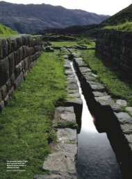
<strong>The</strong> reservoir at Zurraba is an example <strong>of</strong> <strong>the</strong> later<br />
phase technological advances (1 in D;2) (Figs. 1 & 2). It<br />
was constructed to store <strong>and</strong> transmit water along <strong>the</strong><br />
Wadi Shab Qais (D;2) around <strong>the</strong> nor<strong>the</strong>rn flank <strong>of</strong> <strong>the</strong><br />
Jebel el Khubtha mountain (C;2) in an elevated channel<br />
(40 in D;3) containing piping (Fig. 3) that continued<br />
over royal tombs (22, 23, 24 in C;2) to supply a large<br />
basin at its terminus (Fig. 4). This ‘on-dem<strong>and</strong>’ system<br />
supplemented <strong>the</strong> water supplies <strong>of</strong> <strong>the</strong> urban core <strong>of</strong><br />
<strong>the</strong> city (Bourbon 1999). Channels from this basin fed<br />
cisterns at <strong>the</strong> base <strong>of</strong> <strong>the</strong> mountain, adding water to
Charles R. Ortl<strong>of</strong>f<br />
Figure 3. Elevated water channel/piping system on west face <strong>of</strong> El Khubtha<br />
Mountain.<br />
that collected from rainfall run<strong>of</strong>f for urban housing<br />
needs <strong>and</strong> rituals at nearby tomb complexes. While<br />
run<strong>of</strong>f capture probably supplied <strong>the</strong> Zurraba reservoir,<br />
local spring sources, including Ain Mousa, were<br />
also important in <strong>the</strong> early phase <strong>of</strong> city development<br />
<strong>and</strong> may have also contributed water to <strong>the</strong> reservoir.<br />
Although reservoir water could be used to supplement<br />
<strong>the</strong> Siq channel, Ain Mousa water supplies were later<br />
switched to a piping system <strong>and</strong> <strong>the</strong> open channel<br />
was ab<strong>and</strong>oned. Rainfall run<strong>of</strong>f <strong>and</strong> spring flow still<br />
enabled <strong>the</strong> Zurraba reservoir to supplement <strong>the</strong> Siq<br />
pipeline when required. Although <strong>the</strong> modern town<br />
has obliterated ancient hydraulic connections to <strong>and</strong><br />
from <strong>the</strong> reservoir, <strong>the</strong>re is no topographical constraint<br />
to a channel path which would have directed reservoir<br />
water into <strong>the</strong> open channel (or into a later pipeline<br />
system) to provide supplementary water supply. <strong>The</strong><br />
Jebel el Khubtha pipeline, by contrast, appears to be<br />
<strong>the</strong> main outflow path for reservoir water in <strong>the</strong> area<br />
between Jebel el Khubtha <strong>and</strong> Wadi Mataha (B;2, C;2).<br />
Surplus water, after filling <strong>the</strong> cistern, was directed to<br />
<strong>the</strong> main city fountain (Nymphaeum 42, B;2) through<br />
ei<strong>the</strong>r a pipeline or subterranean channel. Although no<br />
traces <strong>of</strong> this connection have been excavated, pipeline<br />
fragments in <strong>the</strong> area suggest this connection. From<br />
a systems point <strong>of</strong> view, <strong>the</strong> Zurraba reservoir served<br />
principally to maintain cistern levels in <strong>the</strong> royal tomb<br />
area by intermittent water release. <strong>The</strong> Ain Mousa<br />
spring, on <strong>the</strong> o<strong>the</strong>r h<strong>and</strong>, provided <strong>the</strong> continuous<br />
supply for <strong>the</strong> Nymphaeum through piping supported<br />
in a carved channel through <strong>the</strong> Siq (Figs. 5a & b) that<br />
replaced <strong>the</strong> earlier open channel. <strong>The</strong> Zurraba reser-<br />
98<br />
voir thus served as a backup system<br />
for rapid delivery <strong>of</strong> large volumes<br />
<strong>of</strong> water at short notice to <strong>the</strong> Jebel el<br />
Khubtha cisterns <strong>and</strong> served to augment<br />
<strong>the</strong> continuous, but declining,<br />
water supply to <strong>the</strong> Nymphaeum<br />
from <strong>the</strong> Ain Mousa spring during<br />
dry seasons. <strong>The</strong> ability to provide<br />
an ‘on-dem<strong>and</strong>’ water supply from<br />
this backup source would have<br />
been most useful to large caravans<br />
entering <strong>the</strong> city that would place<br />
a sudden dem<strong>and</strong> on water supply<br />
<strong>and</strong> usage.<br />
Pipeline carrying capacity<br />
considerations: <strong>the</strong> Zurraba-Jebel<br />
el Khubtha system<br />
While a spring produces a given<br />
volumetric flow rate, <strong>the</strong> limitation<br />
on how much can be transported by pipeline stems<br />
from its technical characteristics (diameter, internal<br />
roughness, slope <strong>and</strong> supply head). Piping design<br />
requires <strong>the</strong> spring output flow rate to match (or<br />
be less than) <strong>the</strong> <strong>the</strong>oretical carrying capacity <strong>of</strong> <strong>the</strong><br />
pipeline. Examination <strong>of</strong> <strong>Nabataean</strong> pipeline designs<br />
yields insights into <strong>the</strong>ir ability to underst<strong>and</strong> internal<br />
pipeline flow phenomena, <strong>and</strong> to construct solutions<br />
to overcome problems limiting maximum throughput.<br />
For an upper estimate <strong>of</strong> <strong>the</strong> volumetric flow rate that<br />
<strong>the</strong> Jebel el Khubtha pipeline system could sustain,<br />
it is assumed that <strong>the</strong> angle <strong>of</strong> about 0.005 shown by<br />
<strong>the</strong> elevated channel supporting <strong>the</strong> pipeline (Figs. 1<br />
& 3) corresponds to <strong>the</strong> critical flow angle (Morris &<br />
Wiggert 1972). <strong>The</strong> maximum flow height within <strong>the</strong><br />
piping is at critical depth equal to perhaps 50 per cent<br />
or more <strong>of</strong> <strong>the</strong> pipe diameter. This condition means<br />
that water flows in open channel mode through <strong>the</strong><br />
piping, with an airspace above <strong>the</strong> water surface, <strong>and</strong><br />
that <strong>the</strong> flow rate is maximum for given diameter <strong>and</strong><br />
slope. This type <strong>of</strong> hydrostatically unpressurized flow<br />
reduces leakage between socketed pipeline elements,<br />
while providing <strong>the</strong> <strong>the</strong>oretical maximum flow rate for<br />
low angle piping functioning in ei<strong>the</strong>r open channel or<br />
full flow mode. <strong>The</strong> maximum flow rate permissible<br />
<strong>the</strong>n would be <strong>the</strong> critical velocity x piping wetted<br />
cross-sectional area. For a fall in channel height <strong>of</strong><br />
about 40 m over <strong>the</strong> 8 km pipeline path around Jebel<br />
el Khubtha, <strong>the</strong> <strong>the</strong>oretical maximum volumetric flow<br />
rate is about 90 m 3 /hr for 20 cm diameter piping. In<br />
practice, owing to <strong>the</strong> many mortared joints between<br />
<strong>the</strong> 0.3 m terracotta piping segments (perhaps <strong>of</strong>
<strong>the</strong> order <strong>of</strong> 30,000) along <strong>the</strong> 8 km<br />
length <strong>of</strong> pipeline, <strong>and</strong> assuming,<br />
for a (very) conservative estimate,<br />
a 50 per cent leakage rate, <strong>the</strong> deliverable<br />
volumetric flow rate can<br />
be readjusted to at least 45 m 3 /hr.<br />
Good hydraulic practice, however,<br />
is to run open channel flow within<br />
piping at lower, subcritical Froude<br />
numbers (Fr < 1) to avoid flow instabilities<br />
caused by joint/channel wall<br />
roughness <strong>and</strong> sinuosity resistance.<br />
Froude number is defined as Fr =<br />
V/(gD) 1/2 , where V is <strong>the</strong> flow velocity,<br />
D <strong>the</strong> hydraulic diameter <strong>and</strong> g<br />
<strong>the</strong> gravitational constant. Thus <strong>the</strong><br />
deliverable flow rate needs to be adjusted<br />
fur<strong>the</strong>r downward to produce<br />
a steady, open-channel flow within<br />
<strong>the</strong> piping. For Froude numbers <strong>of</strong><br />
<strong>the</strong> order <strong>of</strong> 0.6–0.8, <strong>and</strong> with leakage<br />
effects included, a deliverable, stable flow rate <strong>of</strong> <strong>the</strong><br />
order <strong>of</strong> 30 m 3 /hr could have been directed toward<br />
<strong>the</strong> Nymphaeum from <strong>the</strong> Jebel el Khubtha pipeline.<br />
If this long piping system were to function in full-flow<br />
mode, flow rate would be somewhat less than that<br />
derived from an open channel mode owing to internal<br />
wall friction. This generic observation was made in <strong>the</strong><br />
early centuries AD (Vitruvius 1999: ‘. . . for a supply<br />
reservoir water height, long pipe lengths (containing<br />
full flow) diminish water transport amounts due to<br />
(cumulative) internal flow resistance effects . . .’; this<br />
result has been computationally verified (Ortl<strong>of</strong>f &<br />
Crouch 2001; Fig. 2) to quantify Vitruvius’s comment.<br />
A piping slope less than that observed would have<br />
required larger diameter piping to match <strong>the</strong> spring<br />
flow rate <strong>and</strong> be subject to greater internal flow resistance.<br />
With a steeper slope, gravitational acceleration<br />
makes flows supercritical (Fr > 1). Rapid supercritical<br />
flows may be subject to intermittent zones <strong>of</strong> subcritical<br />
(Fr < 1) full flow caused by internal wall roughness<br />
<strong>and</strong> curvature resistance (causing velocity slowing)<br />
as well as transient hydraulic jumps that lead to<br />
pulsations in delivery. Such transient effects can lead<br />
to destructive tensile forces that weaken mortared<br />
piping joints. If flow-rate pulsations are transmitted<br />
to both <strong>the</strong> supplying <strong>and</strong> receiving reservoir, sloshing<br />
effects amplify unstable delivery rates. Transient<br />
changes in input head fur<strong>the</strong>r amplify transient tensile<br />
forces <strong>and</strong> leakage from piping joints. <strong>The</strong> best piping<br />
design is <strong>the</strong>refore a partially full (open channel)<br />
flow at near critical conditions that empties water<br />
gently into a terminal reservoir. Selection <strong>of</strong> this pip-<br />
<strong>Water</strong> <strong>Supply</strong> <strong>and</strong> <strong>Distribution</strong> <strong>System</strong> <strong>of</strong> Petra<br />
Figure 4. Elevated settling basin typical <strong>of</strong> <strong>the</strong> El Khubtha channel/piping<br />
system.<br />
99<br />
ing design would be a measure <strong>of</strong> <strong>the</strong> underst<strong>and</strong>ing<br />
<strong>of</strong> hydraulic principles that were required to achieve<br />
a steady flow rate to <strong>the</strong> terminal basin in C;2 <strong>and</strong><br />
would explain <strong>the</strong> high elevation <strong>of</strong> this pipeline (to<br />
maintain a low slope) around Jebel el Khubtha. <strong>The</strong><br />
<strong>Nabataean</strong> design, given slope <strong>and</strong> pipe diameter,<br />
closely matches ‘best practice’ as its maximum carrying<br />
capacity lies above <strong>the</strong> 20–40 m 3 /hr capacity <strong>of</strong> <strong>the</strong><br />
Ain Mousa supply spring assumes to be a possible<br />
(intermittant) supply source to <strong>the</strong> reservoir. It also<br />
provides for <strong>the</strong> largest possible flow rate from <strong>the</strong><br />
Zurraba reservoir to meet ‘on-dem<strong>and</strong>’ large flow<br />
requirements to <strong>the</strong> city centre. Additional benefits<br />
from <strong>the</strong> <strong>Nabataean</strong> design derive from use <strong>of</strong> partial<br />
flow in <strong>the</strong> piping which greatly reduces leakage rate<br />
as compared to a pressurized system. Since particles<br />
settle in <strong>the</strong> reservoir, no particle transport occurs to<br />
clog piping — this is particularly important as access<br />
to <strong>the</strong> high-elevation piping (25 m above ground) on<br />
<strong>the</strong> near-vertical Jebel el Khubtha mountain face (Fig.<br />
3) would prevent easy cleaning. <strong>The</strong> combination <strong>of</strong><br />
all <strong>the</strong>se features indicates that much thought <strong>and</strong><br />
experience went into <strong>the</strong> design <strong>of</strong> this system which<br />
achieved multiple goals that ensured not only system<br />
longevity but also rapid, stable, on-dem<strong>and</strong> water<br />
delivery with minimum leakage.<br />
Additional piping led to <strong>the</strong> Nymphaeum<br />
fountain to complete <strong>the</strong> Jebel el Khubtha circuit<br />
from <strong>the</strong> Zurraba reservoir. As <strong>the</strong> Nymphaeum was<br />
a major water supply to <strong>the</strong> urban core <strong>and</strong> market<br />
areas, much effort was employed to guarantee its<br />
year-round functioning. <strong>The</strong> Siq piping system was
Figure 5a. Piping elements on <strong>the</strong> north side <strong>of</strong> <strong>the</strong> Siq.<br />
supplemented, as required by occasional dem<strong>and</strong>, by<br />
<strong>the</strong> long Jebel el Khubtha pipeline from <strong>the</strong> Zurraba<br />
reservoir.<br />
Supplemental water-supply systems <strong>and</strong> watersupply<br />
redundancy<br />
Cisterns <strong>and</strong> dams on Jebel el Khubtha (Akasheh 2003)<br />
(C;2) captured <strong>and</strong> stored rainfall run<strong>of</strong>f. Some <strong>of</strong> <strong>the</strong><br />
upper-level cisterns appear to have channels leading<br />
to ground-level cisterns that fed urban housing or field<br />
areas to <strong>the</strong> west <strong>of</strong> Jebel el Khubtha, supplementing<br />
Charles R. Ortl<strong>of</strong>f<br />
Figure 5b. Channel trough on <strong>the</strong> north side <strong>of</strong> <strong>the</strong> Siq for placement <strong>of</strong><br />
piping.<br />
100<br />
<strong>the</strong> water supply from <strong>the</strong> Zurraba<br />
system. Intermittent springs located<br />
on Umm el Biyara (A; 1,2) may also<br />
have been important in ancient<br />
times; <strong>the</strong> Arabic name for this<br />
mountain translates as ‘Mo<strong>the</strong>r <strong>of</strong><br />
Springs’. As previously mentioned,<br />
<strong>the</strong> Siq open channel was ab<strong>and</strong>oned<br />
in late <strong>Nabataean</strong> phases <strong>and</strong><br />
replaced by a pipeline system (Figs.<br />
5a & b) that extended to <strong>the</strong> area opposite<br />
<strong>the</strong> <strong>the</strong>atre district (B;1) <strong>and</strong><br />
ended at <strong>the</strong> Nymphaeum. Thus at<br />
least two separate supply lines led to<br />
<strong>the</strong> Nymphaeum to ensure supply<br />
redundancy. <strong>The</strong> construction <strong>of</strong><br />
<strong>the</strong> Siq pipeline system is generally<br />
attributed to Malichus II or his<br />
predecessors, Aretas IV or Obodas<br />
III, in <strong>the</strong> first century BC or early<br />
first century AD (Guzzo & Schneider<br />
2002). <strong>Water</strong> dem<strong>and</strong>s south <strong>of</strong><br />
Wadi Mousa were high on account<br />
<strong>of</strong> <strong>the</strong> nearby marketplace, <strong>the</strong>atre,<br />
temple <strong>and</strong> housing districts <strong>and</strong><br />
significant water resources were<br />
available from <strong>the</strong> north side piping<br />
systems. A pipeline connection<br />
from <strong>the</strong> Nymphaeum to this<br />
area was <strong>the</strong>refore a logical use<br />
<strong>of</strong> surplus water for development<br />
<strong>of</strong> this area. A bridge most likely<br />
carried water from <strong>the</strong> north side<br />
<strong>of</strong> <strong>the</strong> Jebel el Khubtha system in<br />
<strong>the</strong> El Hubtar Necropolis area (20<br />
in B;2) across <strong>the</strong> Wadi Mousa in<br />
<strong>the</strong> vicinity <strong>of</strong> <strong>the</strong> <strong>the</strong>atre (19 in<br />
B;1) but all traces are lost owing to<br />
extensive erosional flood damage.<br />
In addition to water delivered by<br />
<strong>the</strong>se means, <strong>the</strong> <strong>the</strong>atre supply was<br />
supplemented from large, upper-level reservoirs in <strong>the</strong><br />
Wadi Farasa area <strong>and</strong> pipelines originating from Ain<br />
Braq <strong>and</strong> Ain Ammon sources (Fig. 1). <strong>The</strong>se again<br />
indicate built-in supply redundancy from multiple<br />
sources. Some <strong>of</strong> <strong>the</strong> larger reservoirs, <strong>the</strong>refore, appear<br />
to function in connection with a spring supply<br />
system <strong>and</strong> are situated to collect seasonal rainwater<br />
run<strong>of</strong>f. Reservoirs, <strong>the</strong>refore, were mainly to provide<br />
water for occasional peak requirements through piping<br />
or channel systems. Surface cisterns, on <strong>the</strong> o<strong>the</strong>r<br />
h<strong>and</strong>, appear to be opportunistically placed to collect<br />
rainwater run<strong>of</strong>f; o<strong>the</strong>r than seasonal rain recharge,
<strong>the</strong> numerous, widely-scattered<br />
catchments appear to serve local<br />
community needs for supplemental<br />
supplies <strong>of</strong> lower-quality water<br />
when piped water was not readily<br />
accessible.<br />
Traces <strong>of</strong> a south-side piping<br />
system (Fig. 6) are found in front <strong>of</strong><br />
<strong>the</strong> <strong>the</strong>atre. Two parallel pipelines<br />
continue past <strong>the</strong> <strong>the</strong>atre along <strong>the</strong><br />
ridge (B;2) above <strong>the</strong> commercial<br />
district along <strong>the</strong> Roman Cardo (25),<br />
past Hadrian’s Gate (43) [whose<br />
construction is attributed to Aretas<br />
IV], <strong>and</strong> <strong>the</strong> upper <strong>and</strong> lower marketplaces<br />
<strong>and</strong> <strong>the</strong> Paradeisos water<br />
garden (Bedal 2004) to locations<br />
above <strong>the</strong> Great Temple (28, Figs. 1<br />
& 7) (Joukowski 2001; 2003). <strong>The</strong>re<br />
it forms part <strong>of</strong> <strong>the</strong> water supply to<br />
structures located in B;2. <strong>The</strong> system<br />
consists <strong>of</strong> two separate pipelines<br />
that may indicate branch lines<br />
to separate destinations or a later<br />
elevation change that continues<br />
to Q’asr al Bint through <strong>the</strong> Great<br />
Temple to supply <strong>the</strong> Sacrificial<br />
Altar area. No excavations exist to<br />
connect <strong>the</strong> multiplicity <strong>of</strong> subterranean<br />
canals below <strong>the</strong> altar to a<br />
specific water source. Hadrian’s<br />
Gate (43) separates <strong>the</strong> secular commercial<br />
district from <strong>the</strong> western<br />
sacred temple district containing<br />
<strong>the</strong> Great Temple, <strong>the</strong> Temple <strong>of</strong><br />
<strong>the</strong> Winged Lions (26) <strong>and</strong> Q’asr<br />
al Bint. <strong>The</strong> gate reportedly had<br />
a gilded door to control traffic<br />
between sacred <strong>and</strong> secular parts<br />
<strong>of</strong> <strong>the</strong> city. <strong>The</strong> Paradeisos water<br />
garden west <strong>of</strong> <strong>the</strong> gate consisted<br />
<strong>of</strong> an open house situated on a plat-<br />
form isl<strong>and</strong> within a large water-filled basin. Bridge<br />
structures connected <strong>the</strong> isl<strong>and</strong> to outer precincts <strong>and</strong><br />
greenery added to <strong>the</strong> city’s elegance as indicated by<br />
reconstructions reported by Bedal (2004). Strabo (2000)<br />
mentions that <strong>the</strong> city ‘. . . contains many gardens . .<br />
.’ consistent with recent excavation results. <strong>The</strong> basin<br />
walls contain overflow channels as well as supply<br />
piping that may emanate from both <strong>the</strong> Nymphaeum<br />
via a bridge connection <strong>and</strong> from a south side spring<br />
supply system. Overflow water from <strong>the</strong> garden may<br />
<strong>the</strong>n have been directed to lower baths, chambers or<br />
<strong>Water</strong> <strong>Supply</strong> <strong>and</strong> <strong>Distribution</strong> <strong>System</strong> <strong>of</strong> Petra<br />
Figure 6. Dual pipelines continuing past <strong>the</strong> <strong>the</strong>atre to supply tanks (T)<br />
above <strong>the</strong> Cardo.<br />
Figure 7. Great Temple on <strong>the</strong> south side <strong>of</strong> Wadi Mousa.<br />
101<br />
workshops (Browning 1982) close to <strong>the</strong> containing<br />
walls <strong>of</strong> Wadi Mousa before final discharging into<br />
<strong>the</strong> Wadi Siyagh. This is indicative <strong>of</strong> measures to use<br />
water in consecutive downhill structures. Distributed<br />
along this piping system, a number <strong>of</strong> elevated basins<br />
(T in B;2) lined with hydraulic plaster (Fig. 8) served<br />
as receiving basins; earth-fill mound structures extend<br />
from <strong>the</strong> tanks to <strong>the</strong> lower Cardo area <strong>and</strong> served<br />
to support <strong>the</strong> pipeline. As <strong>the</strong> basins are elevated<br />
at a height <strong>of</strong> 20 m on a bluff above <strong>the</strong> Cardo, <strong>the</strong>re<br />
was sufficient head to provide pressurized water for
Figure 8. Fragment <strong>of</strong> one <strong>of</strong> <strong>the</strong> elevated watercollection<br />
basins (T) above <strong>the</strong> Cardo area.<br />
fountains <strong>and</strong> basins in <strong>the</strong> market area below as well<br />
as for <strong>the</strong> Great Temple (<strong>and</strong> possibly Q’asr al Bint).<br />
Since <strong>the</strong> south side <strong>of</strong> <strong>the</strong> urban core contains<br />
<strong>the</strong> marketplace area, water requirements were high;<br />
consequently, additional supplies were channelled to<br />
this area by means <strong>of</strong> an underground channel (B;1;<br />
B;2).This drew combined flows from Ain Braq <strong>and</strong><br />
Ain Ammon about 5 km sou<strong>the</strong>ast <strong>of</strong> <strong>the</strong> urban core<br />
along <strong>the</strong> sides <strong>of</strong> <strong>the</strong> Wadi Farasa to <strong>the</strong> sou<strong>the</strong>rn part<br />
<strong>of</strong> <strong>the</strong> city. Some, as yet, unexcavated branch <strong>of</strong> this<br />
system running through high-elevation channels may<br />
be part <strong>of</strong> <strong>the</strong> system that provided water to piping<br />
in front <strong>of</strong> <strong>the</strong> <strong>the</strong>atre. <strong>Water</strong> from <strong>the</strong>se springs may<br />
have been supplemented by elevated cisterns in <strong>the</strong><br />
Jebel Attuf area (B;1) in one <strong>of</strong> <strong>the</strong> many high places<br />
(12, 13 in B;1) <strong>of</strong> <strong>the</strong> city. <strong>Water</strong> for <strong>the</strong> Lion Fountain<br />
(14 in B;1) <strong>and</strong> al Hamman sacred pool area in <strong>the</strong><br />
vicinity <strong>of</strong> elite tombs (16, 17, 18 in B;1) came from<br />
this supply line, which <strong>the</strong>n continues on to <strong>the</strong> Great<br />
Temple area. It is clear that a continuous spring sup-<br />
Charles R. Ortl<strong>of</strong>f<br />
102<br />
ply was part <strong>of</strong> <strong>the</strong> system from large elevated cistern<br />
on a plateau above <strong>the</strong> Tomb <strong>of</strong> <strong>the</strong> Roman Soldier<br />
(16 in B;1) (Browning 1982) also contributes rainfall<br />
run<strong>of</strong>f water to this system. Details <strong>of</strong> <strong>the</strong> Wadi Farasa<br />
water system in this area (B;1) have been investigated<br />
(Schmid 2002) <strong>and</strong> include large reservoirs <strong>and</strong> piping<br />
systems that not only serve local areas, but also have<br />
sufficient capacity to transfer water fur<strong>the</strong>r west to<br />
<strong>the</strong> Great Temple area. Numerous channels, pipelines<br />
<strong>and</strong> multiple cisterns within, <strong>and</strong> leading from <strong>the</strong><br />
Great Temple, indicate that water supplies within <strong>the</strong><br />
temple were abundant (Joukowski 1999; 2001; 2003).<br />
Pipelines from <strong>the</strong> Great Temple to <strong>the</strong> marketplace<br />
area <strong>and</strong> <strong>the</strong> Q’asr al Bint region served as part <strong>of</strong><br />
<strong>the</strong> water system. Ain Braq, Ain Ammon, <strong>the</strong> spring<br />
in Wadi Turkamaniya, multiple cisterns as well as a<br />
pipeline that may have crossed Wadi Mousa from <strong>the</strong><br />
north side all contributed water to <strong>the</strong> Great Temple<br />
<strong>and</strong> Q’asr al Bint districts. A bridge abutment (45 in<br />
B;2) on <strong>the</strong> north side just west <strong>of</strong> <strong>the</strong> Temple <strong>of</strong> <strong>the</strong><br />
Winged Lions contains some piping elements. <strong>The</strong>se<br />
may represent just such a connection but <strong>the</strong> total<br />
configuration cannot be confirmed without fur<strong>the</strong>r<br />
excavations.<br />
Cognitive decisions: water-supply system network<br />
management operations<br />
<strong>The</strong> incorporation <strong>of</strong> piping networks transformed<br />
<strong>the</strong> water system to meet <strong>the</strong> dem<strong>and</strong>s <strong>of</strong> a large urban<br />
population (estimated to reach 30,000: Guzzo &<br />
Schneider 2002). <strong>The</strong> <strong>Nabataean</strong> water system incorporated<br />
both intermittent, on-dem<strong>and</strong> supplies piped<br />
from large reservoirs or drawn from cisterns <strong>and</strong> continuous<br />
supply systems from remote springs to provide<br />
<strong>the</strong> daily requirements <strong>of</strong> city inhabitants. <strong>The</strong>se<br />
supplies were consciously regulated to meet dem<strong>and</strong><br />
fluctuations arising from special events in different<br />
areas <strong>of</strong> <strong>the</strong> city, superimposed upon daily requirements<br />
delivered to urban fountains. <strong>Water</strong> supplies<br />
were brought close to population concentration areas<br />
so that all were only a few minutes’ walk away from<br />
fountains or supply basins. Regulation <strong>of</strong> <strong>the</strong> system<br />
required bureaucratic oversight, as decisions regarding<br />
storage or release needed not only day vs night<br />
but also seasonal adjustments. Efficiency dictated that<br />
no water could be wasted. As a consequence, transfer<br />
piping from north-side systems (Jebel el Khubtha <strong>and</strong><br />
Siq pipelines to <strong>the</strong> Nymphaeum) provided water that<br />
could be transferred to south-side downhill locations<br />
for fur<strong>the</strong>r usage or storage before final discharge<br />
into <strong>the</strong> Wadi Siyagh. In addition to spring systems<br />
mentioned thus far, water from springs in <strong>the</strong> Wadi
Kharareeb <strong>and</strong> Wadi Ma’aiserat north <strong>of</strong> <strong>the</strong> city may<br />
also have been channelled as far as <strong>the</strong> Great Temple<br />
<strong>and</strong> Q’asr al Bint areas although excavations have not<br />
yet verified <strong>the</strong> total configuration <strong>of</strong> pipelines <strong>and</strong><br />
channels. Additional water supplies were available<br />
from <strong>the</strong> spring at Wadi Siyagh (A;2) <strong>and</strong> elevated<br />
piping or channel systems above tomb facades east<br />
<strong>of</strong> <strong>the</strong> Wadi Siyagh spring may also have fed water<br />
to a large terminal cistern (A:2) in addition to piping<br />
originating in nearby wadis containing springs. An<br />
elevated channel probably supplied large cisterns in<br />
<strong>the</strong> area from ei<strong>the</strong>r rainfall run<strong>of</strong>f collected behind<br />
dam structures or through connection to <strong>the</strong> springs<br />
in this vicinity. <strong>The</strong> Wadi Siyagh spring, even today,<br />
is adequate for <strong>the</strong> local needs <strong>of</strong> scattered rural settlements<br />
in this area. <strong>The</strong> picture thus far developed<br />
is one <strong>of</strong>: a) exploitation <strong>of</strong> major springs for continuous<br />
supply <strong>of</strong> water to multiple city locations by long<br />
pipeline systems; b) reservoirs <strong>and</strong> cisterns recharged<br />
by spring input <strong>and</strong> run<strong>of</strong>f; <strong>and</strong> c) reservoir-pipeline<br />
systems designed so that supplemental reservoir<br />
water can provide on-dem<strong>and</strong> release for special<br />
events or high seasonal dem<strong>and</strong>. Such a well-planned<br />
system required equally well-planned management<br />
that involved measurement <strong>of</strong> stored water as well<br />
as flow rates. <strong>The</strong> simple rectangular geometry <strong>of</strong><br />
major reservoirs made water volume easy to calculate.<br />
Measurement <strong>of</strong> flow rates may have used techniques<br />
developed by Hero <strong>of</strong> Alex<strong>and</strong>ria (Ortl<strong>of</strong>f & Crouch<br />
1998) in previous centuries.<br />
To add to this complexity, dam-based water<br />
storage presents yet a fur<strong>the</strong>r aspect <strong>of</strong> Petra’s water<br />
system. On <strong>the</strong> north side <strong>of</strong> Wadi Mousa, numerous<br />
high-status structures in <strong>the</strong> B;2 quadrant [Temple <strong>of</strong><br />
<strong>the</strong> Winged Lions, Royal Palace (41), North Defense<br />
Wall <strong>and</strong> Fortress (35), Conway Tower (54)] are logically<br />
associated with a dam (d) at Wadi Turkamaniya (B;2)<br />
that may have trapped <strong>and</strong> stored sufficient run<strong>of</strong>f to<br />
provide water to <strong>the</strong> lower reaches <strong>of</strong> <strong>the</strong> Temple <strong>of</strong> <strong>the</strong><br />
Winged Lions, although no excavation data is available.<br />
Prior excavations, however, reveal that lower portions<br />
<strong>of</strong> both <strong>the</strong> Temple <strong>of</strong> <strong>the</strong> Winged Lions <strong>and</strong> <strong>the</strong> Great<br />
Temple spanned <strong>the</strong> Wadi Mousa stream by a bridge.<br />
A destroyed bridge abutment nearby contains pipework<br />
that may have transferred water from <strong>the</strong> south<br />
to <strong>the</strong> north side <strong>of</strong> <strong>the</strong> city (or vice versa). <strong>Supply</strong> redundancy,<br />
achieved by laying pipelines from different<br />
water sources that crossed from one to ano<strong>the</strong>r part <strong>of</strong><br />
<strong>the</strong> city, is an aspect <strong>of</strong> <strong>the</strong> <strong>Nabataean</strong> design approach.<br />
This design philosophy ensures that water supply to<br />
any area may be composed from different sources depending<br />
upon variations in individual spring flow rates <strong>and</strong><br />
reservoir or cistern supplies. Management oversight<br />
<strong>Water</strong> <strong>Supply</strong> <strong>and</strong> <strong>Distribution</strong> <strong>System</strong> <strong>of</strong> Petra<br />
103<br />
must have been in place to monitor <strong>and</strong> to control <strong>the</strong><br />
system network efficiently.<br />
While cisterns are well dispersed through <strong>the</strong><br />
urban settlement area, local sources describe a main<br />
underground channel starting from Ain Bebdbeh<br />
north <strong>of</strong> (D;3) <strong>and</strong> proceeding toward <strong>the</strong> convergence<br />
<strong>of</strong> Wadi Mataha <strong>and</strong> Wadi al Nassara (B;2), <strong>the</strong>n running<br />
into <strong>the</strong> lower north side below <strong>the</strong> temple areas.<br />
<strong>The</strong> complete channel, mentioned by Taylor (2001),<br />
has not been fully explored but certainly added additional<br />
water supply to <strong>the</strong> north side.<br />
<strong>The</strong> <strong>Nabataean</strong> mindset sought to utilize all water<br />
resources. On-site dams constituted yet fur<strong>the</strong>r complexity<br />
to water management. Local histories mention<br />
<strong>the</strong> existence <strong>of</strong> large dams — one on <strong>the</strong> Wadi Mataha<br />
(Taylor 2001), <strong>the</strong> o<strong>the</strong>r on <strong>the</strong> Wadi al Nassara (Fig.<br />
1). Remains indicate that <strong>the</strong>se dams provided water<br />
storage from rainfall run<strong>of</strong>f within urban Petra. Most<br />
likely, dams were in place in o<strong>the</strong>r wadis to store water<br />
<strong>and</strong> to limit erosion or depositional problems within<br />
<strong>the</strong> urban environment. <strong>The</strong> water stored behind dams<br />
additionally served to raise <strong>the</strong> water table, supplying<br />
wells as a backup for <strong>the</strong> cisterns. A well exists<br />
in <strong>the</strong> Byzantine church east <strong>of</strong> (45 in B;2), <strong>and</strong> <strong>the</strong>re<br />
may have been o<strong>the</strong>rs; as yet, none are reported from<br />
<strong>the</strong> limited excavation data. Judging from <strong>Nabataean</strong><br />
placement <strong>of</strong> <strong>the</strong> Wadi Mataha dam (d in B;2), it must<br />
have been an additional third backup water source to<br />
<strong>the</strong> Nymphaeum. Since <strong>the</strong> Ain Mousa spring could<br />
also serve to fill <strong>the</strong> reservoir behind <strong>the</strong> Wadi Mataha<br />
dam through <strong>the</strong> Wadi Shab Quais pipeline branch<br />
from Zurraba, <strong>the</strong> water level behind <strong>the</strong> dam could<br />
have maintained a sufficient level to provide backup<br />
water to <strong>the</strong> Nymphaeum throughout <strong>the</strong> year. <strong>The</strong><br />
Nymphaeum could <strong>the</strong>refore be fed by water from<br />
<strong>the</strong> Wadi Mataha dam, by canal or pipeline from Ain<br />
Bebdbeh, by <strong>the</strong> pipeline along <strong>the</strong> western face <strong>of</strong><br />
Jebel el Khubtha, <strong>and</strong> by <strong>the</strong> north side Siq pipeline.<br />
This degree <strong>of</strong> redundancy indicates that planning for water-supply<br />
variations was a foremost consideration. It was<br />
addressed by a complex design that could tap into various<br />
water resources depending upon relative availability. <strong>The</strong><br />
redundancy guaranteed that if one <strong>of</strong> <strong>the</strong> supplies<br />
failed, o<strong>the</strong>rs would be in place to guarantee water<br />
delivery to <strong>the</strong> urban core throughout <strong>the</strong> year. <strong>The</strong><br />
redundant supply for <strong>the</strong> Nymphaeum illustrates<br />
cognitive planning to maintain <strong>the</strong> city’s market <strong>and</strong><br />
temple areas throughout <strong>the</strong> year, despite summer<br />
heat <strong>and</strong> lack <strong>of</strong> rainfall. <strong>The</strong> ingenuity <strong>of</strong> <strong>the</strong> <strong>Nabataean</strong>s<br />
must have been apparent to visiting traders<br />
who spread fame <strong>of</strong> <strong>the</strong> city’s wealth, architectural<br />
accomplishments <strong>and</strong> water-management expertise<br />
to far corners <strong>of</strong> <strong>the</strong> known world.
Flood control, groundwater recharge <strong>and</strong> <strong>the</strong> Great<br />
Temple water subsystem<br />
Floodwater drainage during <strong>the</strong> rainy season was<br />
a major concern. Since heavy rainfall <strong>and</strong> flooding<br />
characterize <strong>the</strong> Petra area, measures to divert Wadi<br />
Mousa floodwater from <strong>the</strong> Siq by means <strong>of</strong> a bypass<br />
tunnel (8 in C;1), a low dam at <strong>the</strong> Siq entrance <strong>and</strong><br />
raising <strong>of</strong> <strong>the</strong> Siq floor near <strong>the</strong> entrance provided<br />
flood control. While this strategy had proved effective<br />
in deflecting small floods, deliberate infilling<br />
<strong>and</strong> accumulating flood deposits in <strong>the</strong> Siq continued<br />
to help protect against floodwater incursion. Large<br />
flooding events caused damage, but <strong>the</strong>re were also<br />
ingenious ways to utilize <strong>the</strong> sudden water bounty.<br />
Storage dams across <strong>the</strong> numerous wadis intersecting<br />
<strong>the</strong> urban core served to reduce floodwater entry<br />
into <strong>the</strong> city while seepage from <strong>the</strong> impoundments<br />
recharged <strong>the</strong> water table allowing for wells during<br />
protracted drought. Thus some <strong>of</strong> <strong>the</strong> seepage from<br />
dam storage, canals <strong>and</strong> pipelines could be recaptured<br />
<strong>and</strong> used as (groundwater) defence against drought<br />
on a citywide basis.<br />
<strong>The</strong> same idea could also be used on a more<br />
localized basis for elite structures. Within <strong>the</strong> Great<br />
Temple, an elaborate drainage channel system collected<br />
rainfall seepage <strong>and</strong> directed it to a nearby<br />
underground cistern with 50 m 3 capacity (Joukowski<br />
2001) located within <strong>the</strong> upper part <strong>of</strong> <strong>the</strong> temple<br />
structure. A channel from <strong>the</strong> upper part <strong>of</strong> this cistern<br />
conducted overflow water to lower level structures<br />
before exiting to Q’asr al Bint <strong>and</strong> Wadi Siyagh. Large<br />
channels in an upper room south <strong>of</strong> <strong>the</strong> <strong>The</strong>atron<br />
(Joukowski 2003) <strong>of</strong> <strong>the</strong> temple most likely indicate<br />
<strong>the</strong> terminus <strong>of</strong> a subterranean channel from <strong>the</strong> Ain<br />
Braq/Ain Ammon system (B;1, B;2). Additional water<br />
sources may have been available from springs in Wadi<br />
Kharareb <strong>and</strong> Wadi Ma’Aisert (Fig. 1) although intact<br />
piping has yet to be fully explored. Channel water,<br />
supplemented by cistern water to meet peak dem<strong>and</strong>s,<br />
was distributed to subsidiary open cisterns located on<br />
<strong>the</strong> eastern <strong>and</strong> western sides <strong>of</strong> <strong>the</strong> temple, <strong>the</strong>n via<br />
subterranean channels under <strong>the</strong> lower temenos platform<br />
to rooms near <strong>the</strong> temple entrance stairway. Thus<br />
<strong>the</strong> cistern functioned as a reservoir adding stored<br />
run<strong>of</strong>f <strong>and</strong> southmost outer wall seepage water to <strong>the</strong><br />
channel-delivered supply when required — much in<br />
<strong>the</strong> same way as previously-described reservoir-pipeline<br />
systems worked in t<strong>and</strong>em to meet occasional<br />
peak dem<strong>and</strong>s. Here <strong>the</strong> system is contained within<br />
<strong>the</strong> temple itself, <strong>and</strong> its importance as a major canal<br />
terminus <strong>and</strong> water distribution node, is made clear<br />
by <strong>the</strong> complexity <strong>of</strong> hidden channels, cisterns <strong>and</strong><br />
Charles R. Ortl<strong>of</strong>f<br />
104<br />
piping. <strong>The</strong> temple water system, capable always <strong>of</strong><br />
providing ample water supplies for rituals, may have<br />
had special significance to demonstrate <strong>the</strong> premier<br />
role <strong>of</strong> religion in <strong>the</strong> lives <strong>of</strong> <strong>the</strong> <strong>Nabataean</strong>s. Only<br />
later, under Roman rule, are <strong>the</strong>se supplies used for<br />
more utilitarian purposes, perhaps indicating a Roman<br />
predilection for practical concerns.<br />
Many <strong>of</strong> <strong>the</strong> dams (d) shown in Figure 1 are<br />
located on top <strong>of</strong> mountains <strong>and</strong> are meant to store<br />
rain water to slow <strong>and</strong> limit water entry into <strong>the</strong> site<br />
during <strong>the</strong> rainy season. <strong>The</strong>y are not cisterns per se<br />
but ra<strong>the</strong>r operate more as opportunistic water storage<br />
barriers to limit water entry onto <strong>the</strong> site below. <strong>The</strong>y<br />
provide yet ano<strong>the</strong>r source <strong>of</strong> emergency water supply<br />
as water trapped behind <strong>the</strong>m adds to <strong>the</strong> conserved<br />
water supply <strong>of</strong> <strong>the</strong> city.<br />
Technical innovations characterizing <strong>Nabataean</strong><br />
piping systems<br />
<strong>The</strong> piping systems east <strong>of</strong> <strong>the</strong> Great Temple reflect late<br />
Roman modifications to supply additional water for<br />
market <strong>and</strong> commercial structures along <strong>the</strong> Romanized<br />
Cardo. Sections <strong>of</strong> lead pipe running at <strong>the</strong> base <strong>of</strong><br />
<strong>the</strong> platform <strong>of</strong> <strong>the</strong> Great Temple continued eastward<br />
towards this area. Lead piping usually indicates Roman<br />
manufacture so that identification with Roman<br />
modifications is probable. Low-fired clay pipes with<br />
relatively thick walls <strong>and</strong> socketed ends are also characteristic<br />
Roman work. Wall thickness can range from<br />
1 to 6 cm while piping segments range from 30 to 100<br />
cm in length. Internal diameter usually ranges from 20<br />
to 25 cm for most typical urban pipes <strong>and</strong>, while <strong>the</strong><br />
internal surfaces are generally smooth, <strong>the</strong> socketed<br />
ends involve significant constriction <strong>of</strong> <strong>the</strong> bore. Roman<br />
pipe diameters (Vitruvius 1999) are usually st<strong>and</strong>ardized<br />
throughout areas under Roman occupation;<br />
observed Roman piping in Petra generally conforms<br />
to st<strong>and</strong>ard categories. In contrast, some (but not all)<br />
<strong>Nabataean</strong> piping is made from high-fired clays with<br />
thin walls usually on <strong>the</strong> order <strong>of</strong> 5 mm or less with<br />
piping lengths <strong>of</strong> 30 cm or so. Short <strong>Nabataean</strong> piping<br />
segments are <strong>of</strong>ten <strong>the</strong> preferred design as <strong>the</strong>y<br />
conform more easily to sinuous paths <strong>and</strong> allow for<br />
near flush connections that limit leakage. For applications<br />
where piping is laid in long excavated channels<br />
(e.g. Jebel el Khubtha mountainside, Siq walls), flush<br />
mortar infilling was used to reduce leakage. While<br />
<strong>the</strong> Great Temple is <strong>of</strong> <strong>Nabataean</strong> origin, elements <strong>of</strong><br />
<strong>Nabataean</strong> piping remain along with Roman piping.<br />
Excavations have revealed thick-walled Roman piping<br />
butted onto earlier <strong>Nabataean</strong> piping, most likely to<br />
shunt additional water to market areas <strong>of</strong> <strong>the</strong> Cardo
from Great Temple sources. A fur<strong>the</strong>r<br />
characteristic <strong>of</strong> <strong>Nabataean</strong> piping<br />
is that it is usually placed within<br />
channels cut into stone [including<br />
channels cut into mountain slopes<br />
(Figs. 3 & 6), Siq walls (Figs. 5a & b)<br />
<strong>and</strong> civic masonry] <strong>the</strong>n mortared<br />
over to yield a water seal <strong>and</strong> improved<br />
aes<strong>the</strong>tics for civil structures<br />
<strong>and</strong> greater security (protecting <strong>the</strong><br />
supply). Subterranean channels are<br />
found elsewhere in <strong>the</strong> <strong>Nabataean</strong><br />
domain (Levy 1999), <strong>and</strong> <strong>the</strong> concept<br />
<strong>of</strong> hiding water channels <strong>and</strong> sources<br />
served as a defensive measure to<br />
protect vulnerable water supplies<br />
— particularly spring sources distant<br />
from <strong>the</strong> city centre.<br />
<strong>Nabataean</strong> short piping elements<br />
are characterized by a relatively<br />
slight constriction at <strong>the</strong> junction<br />
<strong>and</strong>, within <strong>the</strong> piping interior, by<br />
sinusoidal ripple patterns (Fig. 10)<br />
with wavelengths <strong>of</strong> about 1.0 cm<br />
<strong>and</strong> amplitude <strong>of</strong> 3 mm. Piping in <strong>the</strong><br />
Great Temple area <strong>and</strong> <strong>the</strong>atre shows<br />
rippled interior patterns <strong>of</strong> this type.<br />
Experiments (Walsh 1980; Cary et al.<br />
1980) indicate drag reduction for ripple<br />
geometry similar to that observed<br />
in <strong>Nabataean</strong> piping elements. <strong>The</strong><br />
use <strong>of</strong> such drag-reduction methods<br />
in <strong>Nabataean</strong> piping designs permits<br />
a higher flow rate (on <strong>the</strong> order <strong>of</strong><br />
5 to 10 per cent) for <strong>the</strong> same head<br />
than for smooth interior piping. This<br />
may constitute <strong>the</strong> earliest empirical<br />
observation that minor internal roughness<br />
in piping can increase flow rate,<br />
particularly where connection joints<br />
are smooth. Questions arise as to<br />
whe<strong>the</strong>r <strong>the</strong> ripple patterns are deliberate<br />
or simply a byproduct from manufacturing<br />
processes, but <strong>the</strong>ir appearance in conjunction with<br />
smoo<strong>the</strong>r joint connections may represent a design<br />
refinement to improve flow rate — perhaps revealed<br />
just by empirical observation.<br />
<strong>The</strong> piping system on <strong>the</strong> north side <strong>of</strong> <strong>the</strong> Siq<br />
(Fig. 5b) contained four open drinking basins capable<br />
<strong>of</strong> trapping particles, with easy access for removal.<br />
Dam systems also served to settle particles to improve<br />
water quality before it was delivered to fountains. Long<br />
pipelines (such as <strong>the</strong> Wadi Shab Qais system) are es-<br />
<strong>Water</strong> <strong>Supply</strong> <strong>and</strong> <strong>Distribution</strong> <strong>System</strong> <strong>of</strong> Petra<br />
Figure 9. FLOW-3D calculations <strong>of</strong> a rectilinear model <strong>of</strong> <strong>the</strong> Siq piping for<br />
entry full flow input flow rates <strong>of</strong> 1.0 (a), 2.0 (b), 5.0 (c), 10.0 (e) ft/s (0.305,<br />
0.610, 1.52, 3.05 m/s) velocity indicating internal flow development for <strong>the</strong><br />
observed wall roughness distribution. Figure 9d shows results for smooth<br />
interior piping at 1.52 m/s initial, full flow inlet velocity (inlet at right).<br />
105<br />
sentially immune to particle clogging effects since <strong>the</strong><br />
upstream reservoir at Zurraba serves as a settling tank.<br />
This reservoir appears to have multiple sections that<br />
may represent some form <strong>of</strong> internal particle settling<br />
capability; however, no detailed excavations <strong>of</strong> silt<br />
types are available. Thus water-quality improvements<br />
went toge<strong>the</strong>r with reduction <strong>of</strong> sediments trapped<br />
in pipelines <strong>and</strong> provided substantial benefits to <strong>the</strong><br />
continuous operation <strong>of</strong> <strong>the</strong> Petra water system.<br />
If <strong>the</strong> piping lengths are very long, wall friction<br />
limits flow rate <strong>and</strong> increases in pressure head do not
Figure 10. Typical rippled wall pattern within <strong>the</strong><br />
interior <strong>of</strong> <strong>Nabataean</strong> piping.<br />
translate proportionately into flow rate increases (Ortl<strong>of</strong>f<br />
& Crouch 2001). For this reason, long pipelines,<br />
where feasible, are usually interrupted by open basins<br />
placed along <strong>the</strong>ir length, effectively to create short<br />
piping segments between (cleanable) head basins. Such<br />
a system permits higher flow rates than a continuous<br />
pipeline with no intermediate basins. Although this<br />
practice is observed in Roman piping networks (Ortl<strong>of</strong>f<br />
& Crouch 2001), it is probably an innovation <strong>of</strong><br />
pre-Roman times. <strong>The</strong> piping on <strong>the</strong> north side <strong>of</strong> <strong>the</strong><br />
Siq provided <strong>the</strong> main potable water supply. <strong>The</strong> southside<br />
channel, on <strong>the</strong> o<strong>the</strong>r h<strong>and</strong>, was probably meant for<br />
animal watering purposes <strong>and</strong> may have been supplied<br />
by a channel from Ain Braq <strong>and</strong> supplemented from a<br />
cistern atop <strong>the</strong> bluffs with a drop hole to this channel<br />
(C0, Fig. 1). This may have fed <strong>the</strong> south-side systems<br />
in <strong>the</strong> <strong>the</strong>atre district but it is not possible to verify this<br />
connection at present.<br />
<strong>The</strong> Siq piping system — flow stability<br />
considerations<br />
<strong>Nabataean</strong> pipeline design solutions can best be illustrated<br />
by a computer analysis that reproduces internal<br />
flow details. To examine flow stability in <strong>the</strong> Siq northside<br />
piping, sample computer models were made <strong>of</strong><br />
a 1220-m-long section with 14.0-cm-diameter piping<br />
inclined at a 2.5 degree angle with <strong>and</strong> without internal<br />
roughness. <strong>The</strong> Ain Mousa spring had a high flow rate<br />
which <strong>the</strong> Siq piping system must have accommodated.<br />
A number <strong>of</strong> sample FLOW-3D computer runs (Flow<br />
Science Inc. 2003) were made for velocities <strong>of</strong> 0.305 (Fig.<br />
9a), 0.610 (Fig. 9b), 1.524 (Fig. 9c), 3.05 (Fig. 9e), 6.10 <strong>and</strong><br />
Charles R. Ortl<strong>of</strong>f<br />
106<br />
9.15 m/s using <strong>the</strong> measured slope <strong>and</strong> wall roughness.<br />
One criterion for determining an acceptable flow rate<br />
relies on flow stability (i.e. is flow smoothly delivered<br />
to a destination point without pulsations?). A second<br />
criterion asks if <strong>the</strong> flow delivered to an open basin can<br />
be successively transported to <strong>the</strong> next pipeline segment<br />
without spillage <strong>and</strong> if a stable free surface flow<br />
exists in <strong>the</strong> piping that can transfer water smoothly to<br />
sequential pipelines interrupted by intermediate basins<br />
without sloshing. For this to occur, pipeline segments<br />
between basins must have <strong>the</strong> same resistance characteristics,<br />
similar internal flow patterns <strong>and</strong> <strong>the</strong> same<br />
entry conditions. A third criterion requires that <strong>the</strong> flow<br />
rate is sufficiently high to accommodate urban-core water<br />
needs for a population <strong>of</strong> 30,000. A fur<strong>the</strong>r criterion<br />
is minimization <strong>of</strong> leakage. Here partial (internal open<br />
channel) flow is preferable as hydrostatic pressure effects<br />
causing leakage are reduced.<br />
<strong>The</strong> results indicate that flow velocities up to 1.52<br />
m/s (Figs. 9 a, b, c), with prescribed wall roughness as<br />
shown in Figures 5a <strong>and</strong> 10, produce an open channel<br />
flow within <strong>the</strong> piping but with an apparent unsteady<br />
delivery rate. This is manifested by r<strong>and</strong>om water<br />
peaks that translate down <strong>the</strong> piping leading to an<br />
unsteady delivery resulting in possible sloshing <strong>and</strong><br />
spillage in open basins along <strong>the</strong> length <strong>of</strong> <strong>the</strong> piping.<br />
For piping with a smooth interior at this flow rate a<br />
smooth delivery flow rate can be achieved (Fig. 9d),<br />
but at <strong>the</strong> expense <strong>of</strong> a longer pipeline segment exposed<br />
to hydrostatic pressure <strong>and</strong> increased leakage.<br />
At a higher 3.05 m/s flow velocity (Fig. 9e), effects <strong>of</strong><br />
<strong>the</strong> roughness-induced, r<strong>and</strong>omly-distributed water<br />
height changes disappear over much <strong>of</strong> <strong>the</strong> piping<br />
length leading to smooth free surface flow. This high<br />
speed flow turns back to a full flow after nearly 1200 m<br />
owing to cumulative wall friction effects (Fig. 9e). This<br />
negative feature can, however, easily be removed by<br />
<strong>the</strong> ‘head reset’ feature so that shorter length pipe segments<br />
connect open basins with open channel flows<br />
up to 400 m in length. This would require at least four<br />
north side basins within <strong>the</strong> Siq. Without open basins,<br />
an uninterrupted pipeline would contain an unsteady<br />
flow <strong>and</strong> require a large downstream settling basin<br />
to trap particles before fur<strong>the</strong>r distribution. <strong>The</strong> Siq<br />
excavator (Bellwald 2004, pers. comm.) has recently<br />
confirmed that <strong>the</strong>re are four open basins within <strong>the</strong><br />
Siq. <strong>The</strong>se would hence not only have provided drinking<br />
water for entrants to <strong>the</strong> city but also provided an<br />
elegant yet practical solution to <strong>the</strong> problem <strong>of</strong> flow<br />
stability. <strong>Water</strong> velocity <strong>of</strong> c. 3.0 m/s is adequate to<br />
prevent major instabilities <strong>and</strong> since <strong>the</strong> supercritical<br />
flow fills about 25 per cent <strong>of</strong> <strong>the</strong> piping cross-section<br />
(at normal depth) <strong>and</strong> allow a (very conservative) 50
per cent for leakage, spillage <strong>and</strong> evaporation, <strong>the</strong>n<br />
<strong>the</strong> deliverable Siq flow rate approaches 36.0 m 3 /hr,<br />
well within <strong>the</strong> maximum Ain Mousa spring flow rate.<br />
Since <strong>the</strong> (on-dem<strong>and</strong>) Wadi Shab Qais water-supply<br />
capability can be around 30 m 3 /hr, maximum northside<br />
water supply that could be carried through <strong>the</strong>se<br />
two piping systems is estimated at about 60 m 3 /hr.<br />
Some control over entry flow rates into each piping<br />
system must have been in place, <strong>and</strong> <strong>the</strong> storage or<br />
release <strong>of</strong> <strong>the</strong> Zurraba reservoir must have been adjusted<br />
in line with seasonal spring or run<strong>of</strong>f supply.<br />
<strong>The</strong> predicted 35 m 3 /hr flow rate is consistent with<br />
current-day Ain Mousa flow rates (Markoe 2003) <strong>of</strong><br />
20–40 m 3 /hr although past rates cannot be known<br />
with certainty.<br />
<strong>The</strong> Siq <strong>and</strong> Jebel el Khubtha pipelines are <strong>of</strong><br />
different designs <strong>and</strong> demonstrate <strong>the</strong> ability <strong>of</strong> <strong>Nabataean</strong><br />
engineers to produce designs to suit different<br />
purposes. While <strong>the</strong> Jebel el Khubtha <strong>and</strong> Siq piping<br />
systems have a 7X slope difference (<strong>the</strong> former by<br />
selective design, <strong>the</strong> latter dictated by topography),<br />
<strong>the</strong> presence <strong>of</strong> head reset basins for <strong>the</strong> Siq system<br />
permits use <strong>of</strong> short piping lengths to maintain low<br />
flow resistance, <strong>and</strong> so sustains a high flow rate.<br />
Although Siq piping internal open channel flows are<br />
supercritical (Fr > 1) owing to <strong>the</strong> steep slope, <strong>the</strong>re is<br />
no possibility <strong>of</strong> achieving near-critical maximum flow<br />
rates given <strong>the</strong> slope <strong>and</strong> diameter <strong>of</strong> <strong>the</strong> pipes. <strong>The</strong><br />
net result is a design that meets criteria for a high flow<br />
rate <strong>and</strong> delivery stability. <strong>The</strong> long, uninterrupted<br />
Jebel el Khubtha pipeline maintained a high subcritical<br />
(Fr < 1), open channel flow that gave a large flow<br />
rate without instabilities. <strong>The</strong> Zurraba reservoir acted<br />
as a settling tank to remove particles, <strong>and</strong> <strong>the</strong> low<br />
velocity <strong>of</strong> 1.25 m/s provided stable delivery, a flow<br />
rate close to <strong>the</strong> maximum <strong>the</strong>oretical value, reduced<br />
leakage, elimination <strong>of</strong> clogging effects <strong>and</strong> sufficient<br />
height at <strong>the</strong> terminal basin to supply fur<strong>the</strong>r piping.<br />
<strong>The</strong> hydraulic design differences <strong>of</strong> <strong>the</strong>se two pipeline<br />
systems indicates an underst<strong>and</strong>ing <strong>of</strong> different<br />
design options for different flow problems. <strong>The</strong> fact<br />
that few, if any, Roman additions were made to <strong>the</strong><br />
water-supply situation may be an indication that <strong>the</strong><br />
<strong>Nabataean</strong>s had already exploited all available water<br />
sources <strong>and</strong> that Roman technological improvements<br />
could not significantly improve upon existing <strong>Nabataean</strong><br />
technologies.<br />
Petra per capita water availability compared to<br />
Roman st<strong>and</strong>ards<br />
For estimates <strong>of</strong> total water flow into <strong>the</strong> city, we may<br />
conservatively assume a north-side supply approxi-<br />
<strong>Water</strong> <strong>Supply</strong> <strong>and</strong> <strong>Distribution</strong> <strong>System</strong> <strong>of</strong> Petra<br />
107<br />
mately one third that <strong>of</strong> <strong>the</strong> south-side rate owing to<br />
<strong>the</strong> less robust south-side springs. Assuming a combined<br />
flow rate between <strong>the</strong> Siq <strong>and</strong> Wadi Shab Qais<br />
reservoir release lines to be about 40 m 3 /hr, <strong>the</strong>n <strong>the</strong><br />
city could receive at minimum an estimated 50 m 3 /hr<br />
from <strong>the</strong>se sources. Additional sources [Ain Braq (0.8<br />
m 3 /hr), Ain Dabdabah (2.5 m 3 /hr), Ain Ammon <strong>and</strong><br />
Ain Siyagh (
may have found use in later hydraulic planning by <strong>the</strong><br />
<strong>Nabataean</strong>s — particularly to match spring flow rates<br />
with piping flow rate capacity.<br />
<strong>Nabataean</strong> overall water-system design strategy<br />
Early use <strong>of</strong> spring-fed pipelines in Hellenistic cities<br />
<strong>of</strong> Ionia, mainl<strong>and</strong> Greece <strong>and</strong> <strong>the</strong> Greek colonies<br />
(Crouch 1993) <strong>and</strong> in contemporary Roman cities indicates<br />
that pipeline technology was well developed<br />
in many parts <strong>of</strong> <strong>the</strong> ancient world <strong>and</strong> was available<br />
for assimilation into <strong>Nabataean</strong> water system.<br />
<strong>The</strong> <strong>Nabataean</strong> systems, however, are unique in that<br />
water conservation is practiced on a much larger scale<br />
<strong>and</strong> intermittent supplies from seasonal rainfall were<br />
exploited to sustain <strong>the</strong> city through dry seasons. In essence,<br />
<strong>the</strong> <strong>Nabataean</strong>s utilized all possible above-<strong>and</strong>-below<br />
ground water supply <strong>and</strong> storage methodologies simultaneously.<br />
While water storage in contemporary Hellenistic<br />
cities also emphasized cisterns for household use, <strong>the</strong><br />
Petra systems advanced this technology to citywide<br />
systems with elaborate dams <strong>and</strong> cisterns that served<br />
both water storage <strong>and</strong> flood control purposes. <strong>Water</strong><br />
storage in aquifers was promoted through dams; this<br />
allowed for use <strong>of</strong> wells as a backup system should all<br />
o<strong>the</strong>r supplies fail. Provided a cistern could be made<br />
deep enough, it would be resupplied from groundwater,<br />
a technique well known in Bronze <strong>and</strong> Iron Age<br />
cities <strong>of</strong> <strong>the</strong> Near East.<br />
Summary <strong>and</strong> conclusions<br />
A comprehensive water-supply system <strong>of</strong> dams,<br />
cisterns, channels <strong>and</strong> pipelines exploited springs as<br />
well as rainfall run<strong>of</strong>f. While some <strong>of</strong> <strong>the</strong> technology<br />
must have been borrowed from contemporary cities,<br />
<strong>the</strong> limited water resources at Petra, combined<br />
with <strong>the</strong> complex topography led to innovations in<br />
<strong>the</strong> use <strong>of</strong> water-storage methodologies on a citywide<br />
scale where stored run<strong>of</strong>f water provided a sizeable<br />
fraction <strong>of</strong> yearly requirements <strong>and</strong> served as<br />
a backup to <strong>the</strong> many springs. Examination <strong>of</strong> two<br />
different pipeline systems with very different slopes<br />
<strong>and</strong> delivery requirements (one on-dem<strong>and</strong> <strong>and</strong> <strong>the</strong><br />
o<strong>the</strong>r continuous flow) indicates that technology (<strong>and</strong><br />
experience to employ it) was in place to provide different<br />
designs that minimized leakage, maximized <strong>the</strong><br />
flow rate, minimized particle ingestion <strong>and</strong> clogging<br />
<strong>and</strong> eliminated transient flow instabilities. <strong>The</strong> Siq<br />
pipeline incorporated water purification by means <strong>of</strong><br />
four well-placed settling basins which also solved a<br />
complex flow stability problem. <strong>The</strong> range <strong>of</strong> solutions<br />
adopted confirms that a hydraulic design methodol-<br />
Charles R. Ortl<strong>of</strong>f<br />
108<br />
ogy was in place <strong>and</strong> was applied with great cognitive<br />
skill to solve complex hydraulic problems.<br />
It is traditional to look for Roman technical advances<br />
that improved <strong>the</strong> <strong>Nabataean</strong> system, but few<br />
are found. This indicates that Roman engineers may<br />
have viewed <strong>the</strong> <strong>Nabataean</strong> system as near-optimum.<br />
In that case, it is likely that <strong>the</strong> several water-management<br />
techniques observed by <strong>the</strong> Romans may<br />
have been borrowed by <strong>the</strong>m <strong>and</strong> applied to <strong>the</strong>ir<br />
desert cities <strong>and</strong> outposts. It is clear that <strong>the</strong> success<br />
<strong>and</strong> longevity <strong>of</strong> Petra depended upon its innovative<br />
water-system design which in itself constitutes a vital<br />
chapter in <strong>the</strong> history <strong>of</strong> water management in <strong>the</strong><br />
ancient Near East.<br />
References<br />
C.R. Ortl<strong>of</strong>f<br />
CTC/United Defense<br />
Santa Clara, CA 95050<br />
USA<br />
Email: Charles.Ortl<strong>of</strong>f@udlp.com<br />
Akasheh, T., 2003. <strong>Nabataean</strong> <strong>and</strong> modern watershed management<br />
around <strong>the</strong> Siq <strong>and</strong> Wadi Mousa in Petra,<br />
in Hashemite University Report, <strong>The</strong> Hashemite University,<br />
Zarqa, Jordan. Zarqa: Hashemite University<br />
Press, 1–15.<br />
Auge, C. & J. Denzer, 2000. Petra, Lost <strong>City</strong> <strong>of</strong> <strong>the</strong> Ancient<br />
World. New York (NY): H. Abrams, Inc. Publishers.<br />
Bedal, A., 2004. <strong>The</strong> Petra Pool-Complex: a Hellenistic Paradeisos<br />
in <strong>the</strong> <strong>Nabataean</strong> Capital. Piscataway (NJ): Gorgias<br />
Press.<br />
Bourbon, F., 1999. Petra, Art, History <strong>and</strong> Itineraries in <strong>the</strong><br />
<strong>Nabataean</strong> Capital. Rome: Grafedit Publishers.<br />
Bowersock, G., 1983. Roman Arabia. Cambridge (MA): Harvard<br />
University Press.<br />
Browning, I., 1982. Petra. London: Chatto & Windus Publishers.<br />
Butterfield, R., 1964. Ancient Rome. New York (NY): Odyssey<br />
Press.<br />
Cary, A., L. Weinstein & D. Bushnell, 1980. Viscous flow<br />
drag reduction, in Drag Reduction Characteristics <strong>of</strong><br />
Small Amplitude Rigid Surface Waves. (AIAA Progress<br />
in Astronautics <strong>and</strong> Astronautics 72.) New York (NY):<br />
American Institute <strong>of</strong> Aeronautics <strong>and</strong> Astronautics,<br />
144–67.<br />
Cohen, M. & I. Drabkin, 1966. A Sourcebook in Greek Science.<br />
Cambridge (MA): Harvard University Press, 336–42.<br />
Crouch, D., 1993. <strong>Water</strong> Management in Ancient Greek Cities.<br />
Oxford: Oxford University Press.<br />
Flow Science Inc., 2003. Flow Science User’s Manual. Santa Fe<br />
(NM): Flow Science, Inc.<br />
Glueck, N., 1959. Rivers in <strong>the</strong> Desert. New York (NY): Straus<br />
<strong>and</strong> Cudahy Publishers.<br />
Glueck, N., 1965. Deities <strong>and</strong> Dolphins. New York (NY):
Strauss <strong>and</strong> Cudahy Publishers.<br />
Guzzo, M. & E.E. Schneider, 2002. Petra. Chicago (IL): University<br />
<strong>of</strong> Chicago Press.<br />
Hammond, P., 1973. <strong>The</strong> <strong>Nabataean</strong>s – <strong>The</strong>ir History, Culture<br />
<strong>and</strong> Archaeology. (Studies in Mediterranean Archaeology<br />
37.) Go<strong>the</strong>nburg: Go<strong>the</strong>nburg Publishers.<br />
Josephus, 1960. Complete Works (<strong>The</strong> Antiquities <strong>of</strong> <strong>the</strong> Jews,<br />
<strong>The</strong> Wars <strong>of</strong> <strong>the</strong> Jews). Gr<strong>and</strong> Rapids (MI): Kregal<br />
Publications.<br />
Joukowski, M.S., 1999. <strong>The</strong> Great Temple, in Brown University<br />
Excavations 1993–1999, vol. 1. Providence (RI): Brown<br />
University Publications, 2–45.<br />
Joukowski, M.S., 2001. <strong>The</strong> Great Temple <strong>of</strong> Petra, in Archaeology<br />
in Jordan, 2001 Season, eds. S. Savage, K.<br />
Zamora & D.R. Keller. American Journal <strong>of</strong> Archaeology<br />
106, 435–58.<br />
Joukowski, M.S., 2003. Petra: <strong>the</strong> Great Temple Excavation,<br />
2002 Field Campaign. Providence (RI): Brown University<br />
Report.<br />
Levy, U., 1999. <strong>The</strong> Lost Civilization <strong>of</strong> Petra. Cambridge (MA):<br />
Floris Books.<br />
Lewis, M.J.T., 2001. Surveying Instruments <strong>of</strong> Greece <strong>and</strong> Rome.<br />
Cambridge: Cambridge University Press.<br />
Markoe, G., 2003. Petra Rediscovered. New York (NY): Harry<br />
N. Abrams, Inc. Publishers.<br />
Morris, H. & J. Wiggert, 1972. Applied Hydraulics in Engineering.<br />
New York (NY): <strong>The</strong> Ronald Press.<br />
Nehme, L., 2000. <strong>The</strong> world <strong>of</strong> <strong>the</strong> <strong>Nabataean</strong>s, in <strong>The</strong> Levant,<br />
ed. O. Binst. Cologne: Konemann Verlagsgesellshaft<br />
mbH, 37–63.<br />
Ortl<strong>of</strong>f, C.R. & D. Crouch, 1998. Hydraulic analysis <strong>of</strong> a<br />
self-cleaning drainage outlet at <strong>the</strong> Hellenistic <strong>City</strong> <strong>of</strong><br />
<strong>Water</strong> <strong>Supply</strong> <strong>and</strong> <strong>Distribution</strong> <strong>System</strong> <strong>of</strong> Petra<br />
109<br />
Priene. Journal <strong>of</strong> Archaeological Science 25, 1211–20.<br />
Ortl<strong>of</strong>f, C.R. & D. Crouch, 2001. <strong>The</strong> urban water supply<br />
<strong>and</strong> distribution system <strong>of</strong> <strong>the</strong> Ionian city <strong>of</strong> Ephesos<br />
in <strong>the</strong> Roman Imperial period. Journal <strong>of</strong> Archaeological<br />
Science 28, 843–60.<br />
Schmid, S., 2002. <strong>The</strong> International Wadi Al-Farasa Project.<br />
Basel, Switzerl<strong>and</strong>: Association for <strong>the</strong> Underst<strong>and</strong>ing<br />
<strong>of</strong> Ancient Cultures Report 2002.<br />
Strabo, 2000. Geography, vol. VII: Books 15–16. (<strong>The</strong> Loeb<br />
Classical Library.) Cambridge (MA): Harvard University<br />
Press.<br />
Taylor, J., 2001. Petra <strong>and</strong> <strong>the</strong> Lost Kingdom <strong>of</strong> <strong>the</strong> <strong>Nabataean</strong>s.<br />
Cambridge (MA): Harvard University Press.<br />
Vitruvius, 1999. Ten books on architecture, Book VIII, in<br />
<strong>The</strong> Loeb Classical Library, ed. F. Grainger. Cambridge<br />
(MA): Harvard University Press, 183–5.<br />
Walsh, M., 1980. Drag characteristics <strong>of</strong> V-groove <strong>and</strong> transverse<br />
curvature riblets, in Viscous Flow Drag Reduction,<br />
ed. G. Hough. (AIAA Progress in Astronautics <strong>and</strong><br />
Astronautics 72.) New York (NY): American Institute<br />
<strong>of</strong> Aeronautics <strong>and</strong> Astronautics, 168–84.<br />
Author biography<br />
C.R. Ortl<strong>of</strong>f is Principal Engineer in <strong>the</strong> Numerical Simulation<br />
Groups at CTC/United Defence in Santa Clara,<br />
California with research interests that focus on use <strong>of</strong><br />
modern computational fluid dynamics (CFD) analysis <strong>and</strong><br />
test methodologies to advance knowledge <strong>of</strong> <strong>the</strong> hydraulic<br />
engineering accomplishments <strong>of</strong> ancient South American,<br />
Meso-American, Sou<strong>the</strong>ast Asian <strong>and</strong> classic Mediterranean<br />
civilizations.
… talking your language<br />
forthcoming textbook<br />
African Archaeology<br />
Third edition<br />
David W. Phillipson<br />
This book provides <strong>the</strong> only<br />
comprehensive <strong>and</strong> up-to-date<br />
examination <strong>of</strong> African archaeology.<br />
Publication April 2005<br />
c.£65.00 | HB | 0 521 83236 5 | 398pp<br />
c.£24.99 | PB | 0 521 54002 X<br />
Ancient Puebloan<br />
Southwest<br />
John Kantner<br />
An introduction to <strong>the</strong> history<br />
<strong>of</strong> <strong>the</strong> Puebloan Southwest<br />
from <strong>the</strong> AD 1000s to <strong>the</strong><br />
sixteenth century.<br />
Case Studies in Early Societies, 5<br />
£50.00 | HB | 0 521 78310 0 | 336pp<br />
£19.99 | PB | 0 521 78880 3<br />
graduate textbook<br />
www.cambridge.org<br />
Ancient Maya<br />
<strong>The</strong> Rise <strong>and</strong> Fall <strong>of</strong> a<br />
Rainforest Civilization<br />
Arthur Demarest<br />
Ancient Maya comes to life<br />
in this new holistic <strong>and</strong><br />
<strong>the</strong>oretical study.<br />
Case Studies in Early Societies, 3<br />
£45.00 | HB | 0 521 59224 0 | 390pp<br />
£18.99 | PB | 0 521 53390 2<br />
Ancient Jomon <strong>of</strong><br />
Japan<br />
Junko Habu<br />
An overview <strong>of</strong> <strong>the</strong> Jomon<br />
period in Japan (circa14,500–<br />
300 BC) within <strong>the</strong> context <strong>of</strong><br />
recent complex hunterga<strong>the</strong>rer<br />
studies.<br />
Case Studies in Early Societies, 4<br />
£50.00 | HB | 0 521 77213 3 | 348pp<br />
£18.99 | PB | 0 521 77670 8<br />
Ancient Cahokia <strong>and</strong><br />
<strong>the</strong> Mississippians<br />
Timothy R. Pauketat<br />
Using a wealth <strong>of</strong><br />
archaeological evidence,<br />
this book outlines <strong>the</strong><br />
development <strong>of</strong><br />
Mississippian civilization.<br />
Case Studies in Early Societies, 6<br />
£40.00 | HB | 0 521 81740 4 | 234pp<br />
£16.99 | PB | 0 521 52066 5<br />
Myths <strong>of</strong> <strong>the</strong><br />
Archaic State<br />
Evolution <strong>of</strong> <strong>the</strong><br />
Earliest Cities, States,<br />
<strong>and</strong> Civilizations<br />
Norman Y<strong>of</strong>fee<br />
This collection presents a new<br />
multi-layered model for <strong>the</strong><br />
evolution <strong>of</strong> ancient societies.<br />
£45.00 | HB | 0 521 81837 0 | 292pp<br />
£19.99 | PB | 0 521 52156 4