Appendix - Society for German Genealogy in Eastern Europe
Appendix - Society for German Genealogy in Eastern Europe
Appendix - Society for German Genealogy in Eastern Europe

You also want an ePaper? Increase the reach of your titles
YUMPU automatically turns print PDFs into web optimized ePapers that Google loves.
Standards <strong>for</strong> locations <strong>in</strong> family data 10.10.2013 Page 18<br />
<strong>Appendix</strong> A<br />
<strong>Appendix</strong> A<br />
How to f<strong>in</strong>d locations <strong>in</strong> <strong>Eastern</strong> <strong>Europe</strong>?<br />
I, Frank Stewner, would like to demonstrate with a few examples of my family how I would f<strong>in</strong>d with<br />
the present possibilities of the <strong>in</strong>ternet locations of my family.<br />
In the 18 th century, many members of the Stefner/Stewner family were liv<strong>in</strong>g <strong>in</strong> the Salzburg area,<br />
Austria and migrated several times dur<strong>in</strong>g the next 250 years: Salzburg -> East-Prussia –><br />
Poland –> Volhynia –> Russia –> Volhynia –> Poland –> <strong>German</strong>y. Many moved from<br />
Volhynia to Canada. I would like to f<strong>in</strong>d the follow<strong>in</strong>g villages:<br />
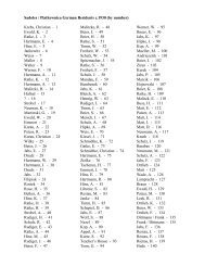
Village County State Country North East Page<br />
St. Johann-Huttegg St. Johann, Salzburg, Austria 471430 131149 18<br />
Kle<strong>in</strong> Degesen/Kle<strong>in</strong> Lucken<br />
(Vyselki), Nesterov, Kal<strong>in</strong><strong>in</strong>grad, Russia 543148 222658 20<br />
Mariampol (Marijampole), Marijampole, Marijampole, Lithuania 543300 232100 23<br />
Przasnysz, Przasnysz, Mazowieckie, Poland 530110 205248 24<br />
Lip<strong>in</strong>y, Ciechanow, Mazowieckie, Poland 524824 202446 26<br />
Makowitz (Makowice/<br />
Makovytsi),<br />
Novograd-<br />
Volynskyi, Zhytomyr, Ukra<strong>in</strong>e 503648 273300 28<br />
Samara (Kuybyshev), Samara, Samara, Russia 531400 501000 31<br />
Pawlodar (Pavlodar), Pavlodar, Pavlodar, Kazakhstan 521656 765744 31<br />
Beschlejewka (Beshleyevka), Chelyab<strong>in</strong>sk, Chelyab<strong>in</strong>sk, Russia 541733 624956 31<br />
Orenburg, Orenburg, Orenburg, Russia 514700 550600 33<br />
Toptscha (Topcza/Topcha), Korets, Rivne, Ukra<strong>in</strong>e 504337 270313 33<br />
Neusalz (Nowa Sol), Nowa Sol, Lubuskie, Poland 514800 154300 33<br />
Posen (Poznan), Poznan, Wielkopolskie, Poland 522426 165453 34<br />
1. St. Johann-Huttegg <strong>in</strong> the Archdiocese of Salzburg, Austrian Empire<br />
I discovered that 8 Stefner/Steffner-families were <strong>for</strong>ced to migrate from the Salzburg area to East-<br />
Prussia. This occurred dur<strong>in</strong>g 1731-32 and was imposed by the Pr<strong>in</strong>ce-Archbishop of Salzburg<br />
Leopold Anton E. Freiherr von Firmian. He ordered the expulsion of those Lutherans who did not<br />
convert to Catholicism. I could not determ<strong>in</strong>e which was my family, there<strong>for</strong>e I am tak<strong>in</strong>g one of the<br />
persons found <strong>in</strong> the book “Gollub’s East-Prussian Salzburger List” on page 365 as an example:<br />
“Steffner Jakob, 34, born <strong>in</strong> the jurisdiction of St. Johann-Hutegg on the Auhof settl<strong>in</strong>g Kle<strong>in</strong><br />
Degesen (=Paulischken), parish Stallupönen.”<br />
I try GOV (refer to page 17) http://gov.genealogy.net and click on the left side on “Sprache<br />
auswählen” and change to the English language. I search <strong>for</strong> Hutegg and f<strong>in</strong>d noth<strong>in</strong>g. Then I try<br />
Google and f<strong>in</strong>d out that the village is written Huttegg. I go directly to Google Earth and enter<br />
Huttegg and get three alternatives seen on the left. The first alternative is the one I am look<strong>in</strong>g <strong>for</strong>.<br />
The l<strong>in</strong>e conta<strong>in</strong>s all the <strong>in</strong>fo I need<br />
to fill <strong>in</strong> the adm<strong>in</strong>istrative units <strong>in</strong><br />
Legacy. But I still need the<br />
coord<strong>in</strong>ates.<br />
I click on 5600 Huttegg, Sankt<br />
Johann im Pongau, Salzburg<br />
Austria.<br />
<strong>Society</strong> <strong>for</strong> <strong>German</strong> <strong>Genealogy</strong> <strong>in</strong> <strong>Eastern</strong> <strong>Europe</strong>, SGGEE <br />
© 2009 Dr. Frank Stewner
Standards <strong>for</strong> locations <strong>in</strong> family data 10.10.2013 Page 19<br />
<strong>Appendix</strong> A<br />
Google Earth shows the coord<strong>in</strong>ates as 47°22’05’’ N and 13°13’30’’ E. I will have to enter <strong>in</strong> Legacy<br />
the coord<strong>in</strong>ates 472205N and 131330E.<br />
Note: In order to get English names of the county and the country you need to use the English<br />
language option. You can control/change the language by click<strong>in</strong>g on “Tools – Options – General –<br />
Language sett<strong>in</strong>gs” (<strong>in</strong> <strong>German</strong> sett<strong>in</strong>g: “Tools – Optionen – Allgeme<strong>in</strong> – Sprache<strong>in</strong>stellungen”) and<br />
choose “English (US)”. You can choose many other languages from Deutsch (<strong>German</strong>) to Русский<br />
(Russian) and Українька (Ukra<strong>in</strong>e). Exception: Google Earth shows the villages always with the<br />
same transcription to English <strong>in</strong> case they use Roman letters!<br />
Important: Google Earth shows the adm<strong>in</strong>istrative levels <strong>in</strong> different colours:<br />
The County (Bezirk): green (on the map above: Sankt Johann im Pongau)<br />
The State (Bundesland): purple-white (you need to enlarge the map to see it)<br />
The Country:<br />
yellow.<br />
Huttegg is situated Northeast of St. Johann im Pongau, the capital of the county St. Johann im<br />
Pongau.<br />
Huttegg, Sankt Johann im Pongau, Salzburg, Austria 471430 N 131149 E<br />
<strong>Society</strong> <strong>for</strong> <strong>German</strong> <strong>Genealogy</strong> <strong>in</strong> <strong>Eastern</strong> <strong>Europe</strong>, SGGEE <br />
© 2009 Dr. Frank Stewner
Standards <strong>for</strong> locations <strong>in</strong> family data 10.10.2013 Page 20<br />
<strong>Appendix</strong> A<br />
2. Kle<strong>in</strong> Degesen <strong>in</strong> parish Stallupönen, a location <strong>in</strong> the prov<strong>in</strong>ce<br />
Ostpreussen of the <strong>German</strong> Empire<br />
My possible ancestor migrated to the area of Gumb<strong>in</strong>nen (Gusev) <strong>in</strong> East-Prussia to the village<br />
Kle<strong>in</strong> Degesen. I decide to use first GOV (choose the English language on the left side by click<strong>in</strong>g<br />
on “Sprache auswählen”, do not use the translator of your browser) to f<strong>in</strong>d Kle<strong>in</strong> Degesen, refer to<br />
chapter 6 page 17: http://gov.genealogy.net/ and enter Kle<strong>in</strong> Degesen <strong>in</strong> the field “place name” and<br />
submit. There is<br />
only one village; I<br />
click on it and am<br />
gett<strong>in</strong>g:<br />
It tells me that<br />
the village was<br />
named Kle<strong>in</strong><br />
Degesen until<br />
1938 and then<br />
was renamed to<br />
Kle<strong>in</strong>lucken. The<br />
Russian name is<br />
Выселкн which is<br />
Vyselki<br />
transcribed <strong>in</strong>to<br />
English and<br />
Wysselki <strong>in</strong><br />
<strong>German</strong> (We<br />
transcribe to<br />
Wyselki!). It tells<br />
me about the<br />
population and<br />
the postal code.<br />
The red dot<br />
marks the<br />
position of that<br />
village and there<br />
are l<strong>in</strong>ks to B<strong>in</strong>g,<br />
Google Earth,<br />
Google Maps and MapQuest based on the coord<strong>in</strong>ates shown as 54.6698°N 22.6109°E, a click on<br />
Google Earth gives the necessary coord<strong>in</strong>ates: 54°40’31’’N 22°36’40’’E.<br />
<strong>Society</strong> <strong>for</strong> <strong>German</strong> <strong>Genealogy</strong> <strong>in</strong> <strong>Eastern</strong> <strong>Europe</strong>, SGGEE <br />
© 2009 Dr. Frank Stewner
Standards <strong>for</strong> locations <strong>in</strong> family data 10.10.2013 Page 21<br />
<strong>Appendix</strong> A<br />
For villages east of the Oder-Neisse l<strong>in</strong>e Kartenmeister (see page 17) is a good alternative to<br />
GOV.<br />
Both differ considerably <strong>in</strong> many aspects, I prefer Kartenmeister:<br />
- Kartenmeister uses solely<br />
the county-structure of 1908.<br />
The structure of GOV is not<br />
consistent.<br />
- Kartenmeister does not give<br />
the “Regierungsbezirke”,<br />
which are confus<strong>in</strong>g with<br />
GOV.<br />
- Kartenmeister gives the<br />
village name valid until 1730<br />
1730: Paulischken.<br />
- Kartenmeister shows the<br />
two parishes, necessary <strong>for</strong><br />
searches.<br />
- Kartenmeisten gives the<br />
coord<strong>in</strong>ates <strong>in</strong> degree and<br />
m<strong>in</strong>utes, which is <strong>in</strong> most<br />
cases precise enough <strong>for</strong><br />
f<strong>in</strong>d<strong>in</strong>g the village.<br />
- GOV is giv<strong>in</strong>g the cyrillic<br />
village name.<br />
- GOV offers more l<strong>in</strong>ks to<br />
maps, Kartenmeister only to<br />
Google maps.<br />
- Kartenmeister offers a l<strong>in</strong>k<br />
to very good “Soviet Map” of<br />
1993 (see next page).<br />
- Both are not giv<strong>in</strong>g the<br />
name of the rayon (county) of<br />
today.<br />
There<strong>for</strong>e I search <strong>in</strong> Wikipedia<br />
and f<strong>in</strong>d Nesterov.<br />
Kle<strong>in</strong> Degesen is situated<br />
north east of Nesterov, the<br />
capital of the rayon Nesterov.<br />
Kle<strong>in</strong> Degesen/Kle<strong>in</strong> Lucken<br />
(Vyselki)<br />
Nesterov, Kal<strong>in</strong><strong>in</strong>grad, Russia 544031 N 223640 E<br />
<strong>Society</strong> <strong>for</strong> <strong>German</strong> <strong>Genealogy</strong> <strong>in</strong> <strong>Eastern</strong> <strong>Europe</strong>, SGGEE <br />
© 2009 Dr. Frank Stewner
Standards <strong>for</strong> locations <strong>in</strong> family data 10.10.2013 Page 22<br />
<strong>Appendix</strong> A<br />
1923 Meßtischblatt 1:25000 with Kl. (Kle<strong>in</strong>) - and Gr. (Groß) Degesen<br />
1993 Soviet military map 1:50000. Old Kle<strong>in</strong> Degesen has disappeared completely and on the<br />
right side of the street there is now a big new build<strong>in</strong>g. Kle<strong>in</strong> Degesen is one of the many villages <strong>in</strong><br />
East-Prussia that have completely disappeared.<br />
-<br />
I could not f<strong>in</strong>d any l<strong>in</strong>k between the many Stefners liv<strong>in</strong>g <strong>in</strong> East-Prussia and my 3 rd greatgrandfather<br />
Jakob Stefner. One son of Jakob was born 1815 <strong>in</strong> Marjanki, Poland and another 1823<br />
<strong>in</strong> Mariampol, Poland. There are 11 Marjanki mentioned with www.mapa.szukacz.pl and I do not<br />
know which one is correct.<br />
<strong>Society</strong> <strong>for</strong> <strong>German</strong> <strong>Genealogy</strong> <strong>in</strong> <strong>Eastern</strong> <strong>Europe</strong>, SGGEE <br />
© 2009 Dr. Frank Stewner
3. Mariampol, a location <strong>in</strong> Lithuania<br />
Standards <strong>for</strong> locations <strong>in</strong> family data 10.10.2013 Page 23<br />
<strong>Appendix</strong> A<br />
When I enter Mariampol <strong>in</strong>to Google Earth only Marijampole <strong>in</strong> Lithuania shows despite the fact that<br />
there are 8 Mariampol <strong>in</strong> Poland accord<strong>in</strong>g to www.mapa.szukacz.pl. (Both GOV and Kartenmeister<br />
are not yet show<strong>in</strong>g villages <strong>in</strong> Congress-Poland.) The biggest <strong>in</strong> Poland has 225 <strong>in</strong>habitants<br />
whereas Marjampole has 70,700.<br />
I enter Mariampol <strong>in</strong>to the <strong>German</strong> Wikipedia and discover that Marijampole is the present-day<br />
name which is Mariampol <strong>in</strong> Polish.<br />
<strong>Society</strong> <strong>for</strong> <strong>German</strong> <strong>Genealogy</strong> <strong>in</strong> <strong>Eastern</strong> <strong>Europe</strong>, SGGEE <br />
© 2009 Dr. Frank Stewner
Standards <strong>for</strong> locations <strong>in</strong> family data 10.10.2013 Page 24<br />
<strong>Appendix</strong> A<br />
The English Wikipedia gives <strong>in</strong><strong>for</strong>mation about the town Marijampole at the beg<strong>in</strong>n<strong>in</strong>g of the 19 th<br />
century: “Follow<strong>in</strong>g the Partitions of Poland (1795) the town was briefly a part of Prussia.<br />
However, after the Napoleonic Wars (1815) it was restored to K<strong>in</strong>gdom of Poland.” Thus my<br />
possible ancestor might have left East-Prussia towards the East and would still have stayed <strong>in</strong><br />
Prussia (the area was named Neu-Ostpreussen = New East-Prussia).<br />
Mariampol must be named as, see page 13:<br />
Mariampol<br />
(Maryampol/Marijampole), Marijampole, Marijampole, Lithuania 543300 N 232100 E<br />
4. Lip<strong>in</strong>y, a location <strong>in</strong> Poland<br />
I discovered that my grandfather He<strong>in</strong>rich Stewner was born <strong>in</strong> 1877 <strong>in</strong> Lip<strong>in</strong>y and his birth was<br />
registered <strong>in</strong> the Przasnysz Lutheran church. How do I proceed to f<strong>in</strong>d Lip<strong>in</strong>y?<br />
First I must f<strong>in</strong>d out where that parish is situated. I open www.mapa.szukacz.pl and enter Przasnysz<br />
<strong>in</strong> the field Miejscowosc (1) and click on Pokaz (2). A map of Przasnysz shows, as luckily (it is very<br />
rare!) there is the only one <strong>in</strong> Poland (3). Przasnysz has 16,918 osob = <strong>in</strong>habitants (4).<br />
I then scale with Zbliż (5) to 8 and get an overview where that village is situated <strong>in</strong> Poland.<br />
<strong>Society</strong> <strong>for</strong> <strong>German</strong> <strong>Genealogy</strong> <strong>in</strong> <strong>Eastern</strong> <strong>Europe</strong>, SGGEE <br />
© 2009 Dr. Frank Stewner
Standards <strong>for</strong> locations <strong>in</strong> family data 10.10.2013 Page 25<br />
<strong>Appendix</strong> A<br />
Przasnysz is situated app. 70 km north of Warszawa, the capital of Poland and is only 30 km<br />
south of the state Warm<strong>in</strong>sko-Mazurskie which <strong>in</strong> 1877 was a part of East-Prussia. We have seen<br />
that Stefners were liv<strong>in</strong>g <strong>in</strong> East-Prussia be<strong>for</strong>e they migrated around 1800 south <strong>in</strong>to Poland. The<br />
frontier between the two prov<strong>in</strong>ces is not drawn on the map. The village Olsztyn, some 70 km north<br />
of Przasnysz, was <strong>for</strong>merly Allenste<strong>in</strong>, a county capital <strong>in</strong> East-Prussia.<br />
There is more <strong>in</strong><strong>for</strong>mation given on Przasnysz:<br />
Przasnysz is the capital of the pow.=powiat (county) przasznyski and belongs to the woj. =<br />
wojewodztwo (state) mazowieckie. (Note: we will always omit the polish special end<strong>in</strong>g <strong>for</strong> the<br />
county and write <strong>in</strong>stead the village name Przasnysz and also write the state name with capital<br />
letters as Mazowieckie.)<br />
Przasnysz has the tel. code 0-29 and the postal code 06-300 … 302.<br />
Przasnysz, Przasnysz, Mazowieckie, Poland 530110 N 205248 E<br />
<strong>Society</strong> <strong>for</strong> <strong>German</strong> <strong>Genealogy</strong> <strong>in</strong> <strong>Eastern</strong> <strong>Europe</strong>, SGGEE <br />
© 2009 Dr. Frank Stewner
Standards <strong>for</strong> locations <strong>in</strong> family data 10.10.2013 Page 26<br />
<strong>Appendix</strong> A<br />
Next I enter Lip<strong>in</strong>y <strong>in</strong> (1). The “6 map” shows 35 red circles as there are 35 villages by the name<br />
Lip<strong>in</strong>y <strong>in</strong> Poland (6). They are listed one after the other on the right side sorted accord<strong>in</strong>g to the<br />
number of <strong>in</strong>habitants (osob). There is only one near Przasnysz and when I move the mouse to that<br />
red circle a yellow w<strong>in</strong>dow opens and shows the number of <strong>in</strong>habitants <strong>for</strong> that location together<br />
with the gm<strong>in</strong>a (municipality).<br />
Next I click on the dot <strong>in</strong> the rectangle (7) which will show only the Lip<strong>in</strong>y near Przasnysz and when<br />
I click on the scale (Zblicz) 13 (8) I will see:<br />
<strong>Society</strong> <strong>for</strong> <strong>German</strong> <strong>Genealogy</strong> <strong>in</strong> <strong>Eastern</strong> <strong>Europe</strong>, SGGEE <br />
© 2009 Dr. Frank Stewner
Standards <strong>for</strong> locations <strong>in</strong> family data 10.10.2013 Page 27<br />
<strong>Appendix</strong> A<br />
The coord<strong>in</strong>ates are given <strong>in</strong> <strong>Europe</strong> as N 52,806728 E 20,412884 which is the same as the North<br />
American N 52.806728 E 20.412884. The state is Mazowieckie and the county is Ciechanow.<br />
When you double-click <strong>in</strong>side the red circle another w<strong>in</strong>dow opens:<br />
That shows the coord<strong>in</strong>ates also as 52° 48‘ 24.6‘’ N and 20° 24‘ 44.2‘’ E or <strong>for</strong> Legacy<br />
524824 N and 202444 E.<br />
Whenever I click on “Zdjecie SAT” (9) I will get the map with Google Earth and when I then click on<br />
“Mapa” the normal map will show aga<strong>in</strong>.<br />
The location is to be named:<br />
Lip<strong>in</strong>y, Ciechanow, Mazowieckie, Poland 524824 N 202446 E<br />
<strong>Society</strong> <strong>for</strong> <strong>German</strong> <strong>Genealogy</strong> <strong>in</strong> <strong>Eastern</strong> <strong>Europe</strong>, SGGEE <br />
© 2009 Dr. Frank Stewner
Standards <strong>for</strong> locations <strong>in</strong> family data 10.10.2013 Page 28<br />
<strong>Appendix</strong> A<br />
And that I saw <strong>in</strong> reality <strong>in</strong> 2006, which is very similar those areas <strong>in</strong> Volhynia where my grandfather<br />
later lived.<br />
4. Makowitz, a location <strong>in</strong> Volhynia<br />
My grandfather, his parents, his grandparents, a brother and a sister migrated around 1882 to<br />
Volhynia. As his father, he also became a teacher–cantor and <strong>in</strong> 1906 married my grandmother Ida<br />
Brokop. Ida was born <strong>in</strong> 1882 <strong>in</strong> Makowitz accord<strong>in</strong>g to my Ahnenpass (it is a Nazi <strong>in</strong>vention with a<br />
4 level pedigree to supposedly prove my be<strong>in</strong>g an Aryan and it is a good source of <strong>in</strong><strong>for</strong>mation).<br />
Another recorded name is Makowetz <strong>in</strong> the St. Petersburg birth file and it is said that the village is<br />
near Nowograd-Wolhynsk. The Brokop family was among the first settlers <strong>in</strong> Volhynia.<br />
The best source <strong>for</strong> Volhynia is GOV http://gov.genealogy.net/ . I select the English language and<br />
alternately enter<br />
both names and ..<br />
f<strong>in</strong>d noth<strong>in</strong>g! I then<br />
enter “Makowi”.<br />
One village lies <strong>in</strong><br />
Ukra<strong>in</strong>e <strong>in</strong> the<br />
Oblast Shitomir and<br />
the Rajon Nowograd-Wolynsk.<br />
That<br />
must be the right<br />
one! The Oblast<br />
and Rayon show<br />
transcriptions <strong>in</strong>to<br />
<strong>German</strong> but we<br />
need the English<br />
ones accord<strong>in</strong>g to<br />
the guidel<strong>in</strong>e.<br />
<strong>Society</strong> <strong>for</strong> <strong>German</strong> <strong>Genealogy</strong> <strong>in</strong> <strong>Eastern</strong> <strong>Europe</strong>, SGGEE <br />
© 2009 Dr. Frank Stewner
Standards <strong>for</strong> locations <strong>in</strong> family data 10.10.2013 Page 29<br />
<strong>Appendix</strong> A<br />
A click on the four names at<br />
left is giv<strong>in</strong>g nearly everyth<strong>in</strong>g<br />
I need:<br />
Village name: 1 st the <strong>German</strong><br />
Makowizy, 2 nd the Russian <strong>in</strong><br />
Cyrillic, 3 rd the Polish<br />
Makowice and 4 th the<br />
Ukra<strong>in</strong>ian name <strong>in</strong> Cyrillic.<br />
The 1 st is the <strong>German</strong><br />
transcription of the Russian<br />
name. Accord<strong>in</strong>g to the<br />
guidel<strong>in</strong>e I need the English<br />
transcription of the Ukra<strong>in</strong>ian<br />
name which I f<strong>in</strong>d with the<br />
help of <strong>Appendix</strong> B as<br />
Makovytsi. But as the<br />
<strong>German</strong>s were us<strong>in</strong>g<br />
Makowitz it will be the first<br />
part of the village name. -<br />
When I click on Google-Earth I will get that picture:<br />
Google Earth is best <strong>for</strong><br />
boundaries, coord<strong>in</strong>ates,<br />
county- and state names,<br />
especially east of Poland.<br />
The county (raion) is given <strong>in</strong> green colour as Novohrad-Volynskyi raion. The county is thus<br />
Novohrad-Volynskyi. When I click on the – sign on the right of the map the Zhytomyr oblast will<br />
<strong>Society</strong> <strong>for</strong> <strong>German</strong> <strong>Genealogy</strong> <strong>in</strong> <strong>Eastern</strong> <strong>Europe</strong>, SGGEE <br />
© 2009 Dr. Frank Stewner
Standards <strong>for</strong> locations <strong>in</strong> family data 10.10.2013 Page 30<br />
<strong>Appendix</strong> A<br />
appear. Thus Google Earth helps me to f<strong>in</strong>d adm<strong>in</strong>istrative levels. Note: it is important to opt <strong>for</strong><br />
the English (US) language <strong>in</strong> order to see all levels <strong>in</strong> English.<br />
I po<strong>in</strong>ted the mouse hand at the end of the arrow <strong>in</strong> the middle of the village and at the bottom of the<br />
map the coord<strong>in</strong>ates show as 50° 36’ 47.50” N 27° 33’ 00.39” which will give the Legacy coord<strong>in</strong>ates<br />
503648 N 273300 E.<br />
A clip of the 1930 Polish 1:100.000 map also shows the cemetery (Cm.) of Kol. Makowice.<br />
The location is to be named:<br />
Makowitz (Makowice<br />
/Makovytsi),<br />
Novohrad-Volynskyi, Zhytomyr, Ukra<strong>in</strong>e 503648 N 273300 E<br />
In 2006 I drove on the motorway M-06<br />
NW of Novohrad-Volynskyi travell<strong>in</strong>g<br />
west to Rivne and passed the rather<br />
large street-sign <strong>for</strong> that small village<br />
display<strong>in</strong>g: “Makovytsi 2 km”. The village<br />
sign at the edge of that village was much<br />
smaller.<br />
SGGEE shows a gazetteer of Volhynian<br />
villages on the homepage (refer to<br />
Chapter 7, page 16). A search there <strong>for</strong><br />
all villages start<strong>in</strong>g with “Makow” gives<br />
the follow<strong>in</strong>g result:<br />
SGGEE location accord<strong>in</strong>g to the guidel<strong>in</strong>e North East<br />
Makow (-/lost), Lokachi, Volyn, Ukra<strong>in</strong>e 505050 245320<br />
Makowitz (Makowice/Makovytsi), Novohrad-Volynskyi, Zhytomyr, Ukra<strong>in</strong>e 503648 273300<br />
Makowiece (Makowszcze/lost), Kovel, Volyn, Ukra<strong>in</strong>e 511050 245710<br />
It is now easy to copy the location and paste it <strong>in</strong>to Legacy.<br />
<strong>Society</strong> <strong>for</strong> <strong>German</strong> <strong>Genealogy</strong> <strong>in</strong> <strong>Eastern</strong> <strong>Europe</strong>, SGGEE <br />
© 2009 Dr. Frank Stewner
Standards <strong>for</strong> locations <strong>in</strong> family data 10.10.2013 Page 31<br />
<strong>Appendix</strong> A<br />
5. Beschlejewka, Russia<br />
After the marriage of my grandparents 5 children were born: my father Ernst 1907, Re<strong>in</strong>hard 1908,<br />
Erna 1910, Margarete 1912 and Robert 1913. In 1914 the family was <strong>for</strong>ced <strong>in</strong>to exile <strong>in</strong> East-<br />
Russia. My grandfather was taken hostage by the Russians and my grandmother and her 5 children<br />
moved East by horse drawn cart, tra<strong>in</strong> and boat. Robert died and was buried <strong>in</strong> Samara.<br />
Samara/Kuybyshev<br />
(Samara),<br />
Samara, Samara, Russia 531400 N 501000 E<br />
F<strong>in</strong>ally they reached Beschlejewka 60 km away from Troitzk as my father wrote later <strong>in</strong> his diary.<br />
Until recently I was unable to f<strong>in</strong>d that village. Then Ludmilla, my 3 rd cous<strong>in</strong> once removed, helped<br />
me. Ludmilla is a member of the large Biberdorf family of which a part was unlucky because they<br />
lived <strong>in</strong> East-Volhynia and were deported by the Soviets be<strong>for</strong>e WW II to the East. Her grandfather<br />
Ewald Biberdorf died 1988 <strong>in</strong><br />
Pawlodar (Pavlodar) Pavlodar, Pavlodar, Kazakhstan 521656 N 765744 E<br />
I told Ludmilla, who now also lives <strong>in</strong> Hamburg, about Beschlejewka and a day later I received an<br />
email from her: "De<strong>in</strong> Beschleevka (Бешлеевка) existiert sich immer noch! In der Nähe von Troitsk<br />
(Троицк) 54° 18' Nord, 62° 50' Ost; übrigens, me<strong>in</strong> Vater erzählte mir, dass <strong>in</strong> Troitsk die größten<br />
militärischen Übungsplätze liegen, auch für die Nuklearen Waffen ... er war da auch mal ...“<br />
She gave me the right name and told me that near Troitsk are the largest military tra<strong>in</strong><strong>in</strong>g camps,<br />
also with nuclear weapons, and her father was also there some time ago…<br />
I entered the coord<strong>in</strong>ates <strong>in</strong>to Google Earth and Beshleevka shows:<br />
<strong>Society</strong> <strong>for</strong> <strong>German</strong> <strong>Genealogy</strong> <strong>in</strong> <strong>Eastern</strong> <strong>Europe</strong>, SGGEE <br />
© 2009 Dr. Frank Stewner
Standards <strong>for</strong> locations <strong>in</strong> family data 10.10.2013 Page 32<br />
<strong>Appendix</strong> A<br />
I entered the coord<strong>in</strong>ates <strong>in</strong>to Legacy <strong>for</strong> the birthplace of the next two children of my grandparents<br />
(Erhard and Wanda) and the B<strong>in</strong>g map shows a distance of 85 km to Troitsk. The Cyrillic<br />
Бешлеевка is to be transcribed <strong>in</strong>to <strong>German</strong> as Beschlejewka, refer to <strong>Appendix</strong> B.<br />
Ludmilla found that village by speak<strong>in</strong>g the name shown <strong>in</strong> our family records aloud and then<br />
spell<strong>in</strong>g it <strong>in</strong> Russian accord<strong>in</strong>gly.<br />
I found out that this method is also a good tool <strong>for</strong> <strong>German</strong> village names found <strong>in</strong> Polish church<br />
books. But one needs a pretty good gasp of the language <strong>for</strong> that method of f<strong>in</strong>d<strong>in</strong>g location names.<br />
Google Earth did not transcribe accord<strong>in</strong>g the rules mentioned <strong>in</strong> <strong>Appendix</strong> B.<br />
Beschlejewka<br />
(Beshleyevka),<br />
, Chelyab<strong>in</strong>sk, Russia 541733 N 624956 E<br />
In 1917 my grandfather moved to Orenburg, Russia, where he worked as a teacher.<br />
Orenburg, , Orenburg, Russia 514700 N 550600 E<br />
<strong>Society</strong> <strong>for</strong> <strong>German</strong> <strong>Genealogy</strong> <strong>in</strong> <strong>Eastern</strong> <strong>Europe</strong>, SGGEE <br />
© 2009 Dr. Frank Stewner
Standards <strong>for</strong> locations <strong>in</strong> family data 10.10.2013 Page 33<br />
<strong>Appendix</strong> A<br />
6. Toptscha, Ukra<strong>in</strong>e<br />
Around 1918 the family returned to Volhynia and he got work as teacher-cantor <strong>in</strong> Toptscha.<br />
Toptscha (Topcza/Topcha), Korets, Rivne, Ukra<strong>in</strong>e 504337 N 270313 E<br />
That is the view from the East along the ma<strong>in</strong> road <strong>in</strong> that Colony Toptscha. The green bushes are<br />
<strong>for</strong>m<strong>in</strong>g a rectangle of the cemetery which I could easily locate with Google Earth. There is still a<br />
Ukra<strong>in</strong>ian village Topcha south of the little river.<br />
7. Neusalz an der Oder, <strong>German</strong> Empire<br />
Around 1922 my father crossed the<br />
frontier to the <strong>German</strong> Empire and<br />
went to the preparat<strong>in</strong>g sem<strong>in</strong>ar <strong>in</strong><br />
Neusalz an der Oder together with<br />
other boys of the village.<br />
Refer to the chronicle of Dr. Herbert<br />
Henke published <strong>in</strong> the SGGEE<br />
Journal Sep 2003 page 25.<br />
All necessary <strong>in</strong><strong>for</strong>mation I f<strong>in</strong>d with<br />
the English Wikipedia.<br />
Neusalz (Nowa Sol), Nowa Sol, Lubuskie, Poland 514800 N 154300 E<br />
And then my father went to the Gymnasium <strong>in</strong> Bielitz, today a part of Bielsko-Biala.<br />
<strong>Society</strong> <strong>for</strong> <strong>German</strong> <strong>Genealogy</strong> <strong>in</strong> <strong>Eastern</strong> <strong>Europe</strong>, SGGEE <br />
© 2009 Dr. Frank Stewner
8. Posen (Poznan) is my birthplace<br />
Standards <strong>for</strong> locations <strong>in</strong> family data 10.10.2013 Page 34<br />
<strong>Appendix</strong> A<br />
After f<strong>in</strong>ish<strong>in</strong>g the teacher sem<strong>in</strong>ar <strong>in</strong> Bielitz my father did not return to Volhynia but went to Posen<br />
(Poznan), s<strong>in</strong>ce 1921 <strong>in</strong> Poland. He married nearby and I was born there February 1939.<br />
Posen (Poznan) is a good example to show the many possible location names accord<strong>in</strong>g to<br />
the time of the event. Somebody was born <strong>in</strong> the year:<br />
1790 <strong>in</strong> Poznan, prov<strong>in</strong>ce Wielkopolskie of the K<strong>in</strong>gdom of Poland.<br />
1800 <strong>in</strong> Posen, prov<strong>in</strong>ce Suedpreussen of the K<strong>in</strong>gdom of Prussia.<br />
1810 <strong>in</strong> Poznan, départment Poznan of the Duchy of Warsaw.<br />
1850 <strong>in</strong> Posen, prov<strong>in</strong>ce Posen of the K<strong>in</strong>gdom of Prussia.<br />
1909 <strong>in</strong> near Posen, prov<strong>in</strong>ce Posen of the <strong>German</strong> Empire. My mother mearby<br />
1939 <strong>in</strong> Poznan, prov<strong>in</strong>ce Poznan of Poland. Myself<br />
1940 <strong>in</strong> Posen, prov<strong>in</strong>ce Warthegau of the “Third Reich”. My sister<br />
1960 <strong>in</strong> Poznan, prov<strong>in</strong>ce Poznan of Poland.<br />
1998 <strong>in</strong> Poznan, prov<strong>in</strong>ce Wielkopolskie of Poland. Valid until today.<br />
I wanted to demonstrate with that list that <strong>in</strong> 210 years there were 8 big changes <strong>in</strong> nam<strong>in</strong>g the<br />
location of Posen (Poznan). There were more changes at the level of the Prov<strong>in</strong>ces/Wojewodztwo<br />
and Counties/Powiats <strong>for</strong> smaller villages. I might come up with up to 20 changes <strong>for</strong> one village <strong>in</strong><br />
200 years, on average 1 <strong>in</strong> every 20 years.<br />
Accord<strong>in</strong>g to the rules of Chapter 5.1.2. and 5.5. I have to name my birthplace as:<br />
Poznan, Poznan, Wielkopolskie, Poland 522426 N 165453 E<br />
-<br />
We have produced this guidel<strong>in</strong>e <strong>for</strong> the 43.000 locations <strong>in</strong> the MPD and <strong>for</strong> those villages that<br />
will be added <strong>in</strong> the future. Some 8,400 have very poor <strong>in</strong><strong>for</strong>mation, ma<strong>in</strong>ly the village name. If only<br />
a village name is known without some general idea where it is located, as <strong>in</strong> the case of the village<br />
Marjanki (refer to page 22), where there are 11 alternatives <strong>in</strong> Poland, it will be most difficult to f<strong>in</strong>d<br />
the correct village. Poland and also Volhynia are exceptional <strong>in</strong> high numbers of alternatives,<br />
reach<strong>in</strong>g often over 50. Only <strong>in</strong> some cases have we been able to f<strong>in</strong>d what we believe is the<br />
correct village by look<strong>in</strong>g at surround<strong>in</strong>g persons and their locations plus other detective methods.<br />
Thus be aware that locations can usually only be found when you have sufficient <strong>in</strong><strong>for</strong>mation about<br />
them and there<strong>for</strong>e we ask that you to help us and others who use your data by list<strong>in</strong>g as much<br />
<strong>in</strong><strong>for</strong>mation as you know about your locations <strong>in</strong> case you were unable to f<strong>in</strong>d the village, so that we<br />
or others may f<strong>in</strong>d it.<br />
-<br />
We hope that you ga<strong>in</strong>ed a better understand<strong>in</strong>g as to why we need standardization and that the<br />
nam<strong>in</strong>g of locations <strong>in</strong> <strong>Eastern</strong> <strong>Europe</strong> is not at all easy.<br />
We hope also that you understand as a result of read<strong>in</strong>g the appendix, that although f<strong>in</strong>d<strong>in</strong>g the<br />
locations of villages can be challeng<strong>in</strong>g, once you f<strong>in</strong>d that location, the records of your ancestors<br />
will mean much more to you, s<strong>in</strong>ce you will be able to see what is now <strong>in</strong> the area where they lived,<br />
and you can also visit that place.<br />
Frank Stewner, liv<strong>in</strong>g <strong>in</strong><br />
Hamburg-St. Georg, Hamburg, Hamburg, <strong>German</strong>y 533321 N 100108 E<br />
<strong>Society</strong> <strong>for</strong> <strong>German</strong> <strong>Genealogy</strong> <strong>in</strong> <strong>Eastern</strong> <strong>Europe</strong>, SGGEE <br />
© 2009 Dr. Frank Stewner
Standards <strong>for</strong> locations <strong>in</strong> family data 07.08.2013 Page 35<br />
<strong>Appendix</strong> B<br />
<strong>Appendix</strong> B Transcription of Cyrillic<br />
There exist numerous ways of transcrib<strong>in</strong>g the Russian and Ukra<strong>in</strong>e Cyrillic <strong>in</strong>to English and <strong>German</strong>. We adopted the<br />
tables of GOV used <strong>for</strong> their transcription of present-day russian and ukra<strong>in</strong>e villages <strong>in</strong> Volhynia and East-Prussia. In the<br />
notes we remark that Google Earth is describ<strong>in</strong>g <strong>in</strong> few cases not the same way as we propose. Thus you will not be able<br />
see with Google Earth exactly the same village names as <strong>in</strong> the SGGEE Gazetteers. On next page is a 1983 transcription<br />
table which <strong>in</strong>cludes handwritten and old letters. It differs from the lists we propose and is not unambiguous.<br />
Transcription of Russian Cyrillic Transcription of Ukra<strong>in</strong>e Cyrillic<br />
Russian <strong>German</strong> transcr. English transcr. Ukra<strong>in</strong>ian English transcription<br />
А а A a A a А а A a<br />
Ь ь B b B b Б б B b<br />
В в W w V v В в V v<br />
Г г G g G g Г г H h<br />
Ґ ґ<br />
G g<br />
Д д D d D d Д д D d<br />
Е е E e, je 1 E e, ye 1 Е е E e<br />
Ё ё Jo jo, o 2 Ye e Є є Ye ie<br />
Ж ж Sh sh Zh zh Ж ж Zh zh<br />
З з S s Z z З з Z z<br />
И и I i I i И и Y y<br />
І і<br />
I i<br />
Ї ї<br />
Yi i<br />
Й й J j 3 Y y Й й Y i 1<br />
К к K k K k К к K k<br />
Л л L l L l Л л L l<br />
М м M m M m М м M m<br />
Н н N n N n Н н N n<br />
О о O o O o О о O o<br />
П п P p P p П п P p<br />
Р р R r R r Р р R r<br />
С с S s S s С с S s<br />
Т т T t T t Т т T t<br />
У у U u U u У у U u<br />
Ф ф F f F f Ф ф F f<br />
Х х Ch ch Kh kh Х х Kh kh<br />
Ц ц Z z Ts ts Ц ц Ts ts<br />
Ч ч Tsch tsch Ch ch Ч ч Ch ch<br />
Ш ш Sch sch Sh sh Ш ш Sh sh<br />
Щ щ Schtsch schtsch Shch shch Щ щ Shch shch<br />
Ъ ъ<br />
Ы ы Y y Y y<br />
Ь ь ь - , j 2<br />
Ю ю Ju ju Yu yu Ю ю Yu iu 3<br />
Я я Ja ja Ya ya Я я Ya ia 4<br />
1. After vowels Apostrophe and soft sign are omitted.<br />
2. After vowels and at the beg<strong>in</strong>n<strong>in</strong>g of a word: Jo or jo. 1. After и: noth<strong>in</strong>g.<br />
But o after ж, ч, ш, щ.<br />
2. Be<strong>for</strong>e o; Google Earth: ‘o<br />
3. After и and ы: noth<strong>in</strong>g. At the end of a word: й->i. 3. Google Earth: Yu yu<br />
Between vowels and between сonsonants: ->i. After 4. Google Earth: Ya ya<br />
и or ы and be<strong>for</strong>e сonsonant: ->j.<br />
Yellow mark differences<br />
<strong>Society</strong> <strong>for</strong> <strong>German</strong> <strong>Genealogy</strong> <strong>in</strong> <strong>Eastern</strong> <strong>Europe</strong>, SGGEE <br />
© 2009 Dr. Frank Stewner
Standards <strong>for</strong> locations <strong>in</strong> family data 07.08.2013 Page 36<br />
<strong>Appendix</strong> B<br />
<strong>Society</strong> <strong>for</strong> <strong>German</strong> <strong>Genealogy</strong> <strong>in</strong> <strong>Eastern</strong> <strong>Europe</strong>, SGGEE <br />
© 2009 Dr. Frank Stewner