Marine biological survey to establish the distribution and status of ...
Marine biological survey to establish the distribution and status of ...
Marine biological survey to establish the distribution and status of ...

You also want an ePaper? Increase the reach of your titles
YUMPU automatically turns print PDFs into web optimized ePapers that Google loves.
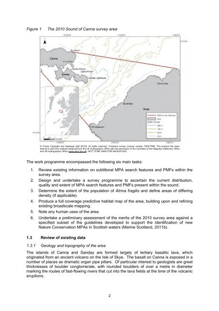
Figure 1<br />
The 2010 Sound <strong>of</strong> Canna <strong>survey</strong> area<br />
© Crown Copyright <strong>and</strong> database right [2012]. All rights reserved. Ordnance <strong>survey</strong> License number 100017908. This product has been<br />
derived in part from material obtained from <strong>the</strong> UK Hydrographic Office with <strong>the</strong> permission <strong>of</strong> <strong>the</strong> Controller <strong>of</strong> Her Majesty's Stationery Office<br />
<strong>and</strong> UK Hydrographic Office (www.ukho.gov.uk). NOT TO BE USED FOR NAVIGATION<br />
The work programme encompassed <strong>the</strong> following six main tasks:<br />
1. Review existing information on sublit<strong>to</strong>ral MPA search features <strong>and</strong> PMFs within <strong>the</strong><br />
<strong>survey</strong> area.<br />
2. Design <strong>and</strong> undertake a <strong>survey</strong> programme <strong>to</strong> ascertain <strong>the</strong> current <strong>distribution</strong>,<br />
quality <strong>and</strong> extent <strong>of</strong> MPA search features <strong>and</strong> PMFs present within <strong>the</strong> sound.<br />
3. Determine <strong>the</strong> extent <strong>of</strong> <strong>the</strong> population <strong>of</strong> Atrina fragilis <strong>and</strong> define areas <strong>of</strong> differing<br />
density (if applicable).<br />
4. Produce a full coverage predictive habitat map <strong>of</strong> <strong>the</strong> area, building upon <strong>and</strong> refining<br />
existing broadscale mapping.<br />
5. Note any human uses <strong>of</strong> <strong>the</strong> area.<br />
6. Undertake a preliminary assessment <strong>of</strong> <strong>the</strong> merits <strong>of</strong> <strong>the</strong> 2010 <strong>survey</strong> area against a<br />
specified subset <strong>of</strong> <strong>the</strong> guidelines developed <strong>to</strong> support <strong>the</strong> identification <strong>of</strong> new<br />
Nature Conservation MPAs in Scottish waters (<strong>Marine</strong> Scotl<strong>and</strong>, 2011b).<br />
1.3 Review <strong>of</strong> existing data<br />
1.3.1 Geology <strong>and</strong> <strong>to</strong>pography <strong>of</strong> <strong>the</strong> area<br />
The isl<strong>and</strong>s <strong>of</strong> Canna <strong>and</strong> S<strong>and</strong>ay are formed largely <strong>of</strong> tertiary basaltic lava, which<br />
originated from an ancient volcano on <strong>the</strong> Isle <strong>of</strong> Skye. The basalt on Canna is exposed in a<br />
number <strong>of</strong> places as dramatic organ pipe pillars. Of particular interest <strong>to</strong> geologists are great<br />
thicknesses <strong>of</strong> boulder conglomerate, with rounded boulders <strong>of</strong> over a metre in diameter<br />
marking <strong>the</strong> routes <strong>of</strong> fast-flowing rivers that cut in<strong>to</strong> <strong>the</strong> lava fields at <strong>the</strong> time <strong>of</strong> <strong>the</strong> volcanic<br />
eruptions.<br />
2