Marine biological survey to establish the distribution and status of ...
Marine biological survey to establish the distribution and status of ...
Marine biological survey to establish the distribution and status of ...

Create successful ePaper yourself
Turn your PDF publications into a flip-book with our unique Google optimized e-Paper software.
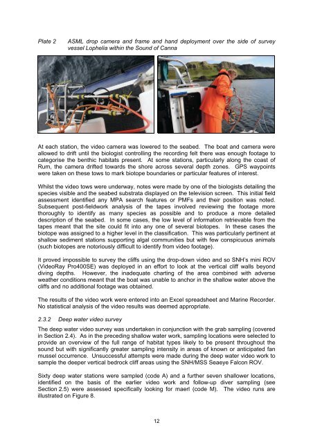
Plate 2<br />
ASML drop camera <strong>and</strong> frame <strong>and</strong> h<strong>and</strong> deployment over <strong>the</strong> side <strong>of</strong> <strong>survey</strong><br />
vessel Lophelia within <strong>the</strong> Sound <strong>of</strong> Canna<br />
At each station, <strong>the</strong> video camera was lowered <strong>to</strong> <strong>the</strong> seabed. The boat <strong>and</strong> camera were<br />
allowed <strong>to</strong> drift until <strong>the</strong> biologist controlling <strong>the</strong> recording felt <strong>the</strong>re was enough footage <strong>to</strong><br />
categorise <strong>the</strong> benthic habitats present. At some stations, particularly along <strong>the</strong> coast <strong>of</strong><br />
Rum, <strong>the</strong> camera drifted <strong>to</strong>wards <strong>the</strong> shore across several depth zones. GPS waypoints<br />
were taken on <strong>the</strong>se <strong>to</strong>ws <strong>to</strong> mark bio<strong>to</strong>pe boundaries or particular features <strong>of</strong> interest.<br />
Whilst <strong>the</strong> video <strong>to</strong>ws were underway, notes were made by one <strong>of</strong> <strong>the</strong> biologists detailing <strong>the</strong><br />
species visible <strong>and</strong> <strong>the</strong> seabed substrata displayed on <strong>the</strong> television screen. This initial field<br />
assessment identified any MPA search features or PMFs <strong>and</strong> <strong>the</strong>ir position was noted.<br />
Subsequent post-fieldwork analysis <strong>of</strong> <strong>the</strong> tapes involved reviewing <strong>the</strong> footage more<br />
thoroughly <strong>to</strong> identify as many species as possible <strong>and</strong> <strong>to</strong> produce a more detailed<br />
description <strong>of</strong> <strong>the</strong> seabed. In some cases, <strong>the</strong> low level <strong>of</strong> information retrievable from <strong>the</strong><br />
tapes meant that <strong>the</strong> site could fit in<strong>to</strong> any one <strong>of</strong> several bio<strong>to</strong>pes. In <strong>the</strong>se cases <strong>the</strong><br />
bio<strong>to</strong>pe was assigned <strong>to</strong> a higher level in <strong>the</strong> classification. This was particularly pertinent at<br />
shallow sediment stations supporting algal communities but with few conspicuous animals<br />
(such bio<strong>to</strong>pes are no<strong>to</strong>riously difficult <strong>to</strong> identify from video footage).<br />
It proved impossible <strong>to</strong> <strong>survey</strong> <strong>the</strong> cliffs using <strong>the</strong> drop-down video <strong>and</strong> so SNH’s mini ROV<br />
(VideoRay Pro400SE) was deployed in an effort <strong>to</strong> look at <strong>the</strong> vertical cliff walls beyond<br />
diving depths. However, <strong>the</strong> inadequate charting <strong>of</strong> <strong>the</strong> area combined with adverse<br />
wea<strong>the</strong>r conditions meant that <strong>the</strong> boat was unable <strong>to</strong> anchor in <strong>the</strong> shallow water above <strong>the</strong><br />
cliffs <strong>and</strong> no additional footage was obtained.<br />
The results <strong>of</strong> <strong>the</strong> video work were entered in<strong>to</strong> an Excel spreadsheet <strong>and</strong> <strong>Marine</strong> Recorder.<br />
No statistical analysis <strong>of</strong> <strong>the</strong> video results was deemed appropriate.<br />
2.3.2 Deep water video <strong>survey</strong><br />
The deep water video <strong>survey</strong> was undertaken in conjunction with <strong>the</strong> grab sampling (covered<br />
in Section 2.4). As in <strong>the</strong> preceding shallow water work, sampling locations were selected <strong>to</strong><br />
provide an overview <strong>of</strong> <strong>the</strong> full range <strong>of</strong> habitat types likely <strong>to</strong> be present throughout <strong>the</strong><br />
sound but with significantly greater sampling intensity in areas <strong>of</strong> known or anticipated fan<br />
mussel occurrence. Unsuccessful attempts were made during <strong>the</strong> deep water video work <strong>to</strong><br />
sample <strong>the</strong> deeper vertical bedrock cliff areas using <strong>the</strong> SNH/MSS Seaeye Falcon ROV.<br />
Sixty deep water stations were sampled (code A) <strong>and</strong> a fur<strong>the</strong>r seven shallower locations,<br />
identified on <strong>the</strong> basis <strong>of</strong> <strong>the</strong> earlier video work <strong>and</strong> follow-up diver sampling (see<br />
Section 2.5) were assessed specifically looking for maerl (code M). The video runs are<br />
illustrated on Figure 8.<br />
12