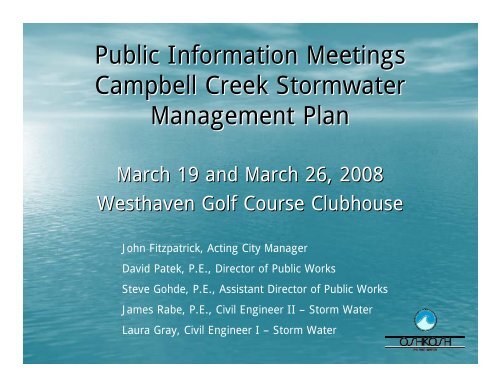
Public Information Meetings Campbell Creek ... - City of Oshkosh
Public Information Meetings Campbell Creek ... - City of Oshkosh
Public Information Meetings Campbell Creek ... - City of Oshkosh

You also want an ePaper? Increase the reach of your titles
YUMPU automatically turns print PDFs into web optimized ePapers that Google loves.
<strong>Public</strong> <strong>Information</strong> <strong>Meetings</strong><br />
<strong>Campbell</strong> <strong>Creek</strong> Stormwater<br />
Management Plan<br />
March 19 and March 26, 2008<br />
Westhaven Golf Course Clubhouse<br />
John Fitzpatrick, Acting <strong>City</strong> Manager<br />
David Patek, P.E., Director <strong>of</strong> <strong>Public</strong> Works<br />
Steve Gohde, P.E., Assistant Director <strong>of</strong> <strong>Public</strong> Works<br />
James Rabe, P.E., Civil Engineer II – Storm Water<br />
Laura Gray, Civil Engineer I – Storm Water
Overview<br />
• Purpose <strong>of</strong> Plan<br />
• Watershed Areas<br />
• Flooding History<br />
• Flooding Analysis<br />
• Water Quality Analysis<br />
• Recommendation<br />
• Other Concerns<br />
• Funding
Purpose <strong>of</strong> Plan<br />
• <strong>City</strong> <strong>of</strong> <strong>Oshkosh</strong> frequently experiences<br />
flooding during rain events.<br />
• EPA mandated DNR to administer storm<br />
water discharge regulations under Clean<br />
Water Act.<br />
• DNR mandated storm water quality<br />
improvements for storm water.
Watershed Areas<br />
• <strong>Campbell</strong> <strong>Creek</strong><br />
– Blue Area<br />
– Green Area<br />
• Sawyer <strong>Creek</strong><br />
– Orange Area<br />
– Green Area<br />
• Stringham <strong>Creek</strong><br />
– Red Area
Flooding History<br />
Flooding Incidents Since 1990<br />
• Four Presidential Disaster Declarations<br />
– 1990, 1993, 2001, 2004<br />
• Four Minor Flooding Incidents<br />
– 1996, 1999 (2), 2000<br />
Source: Winnebago County Hazard Mitigation Plan: 2004-2008
Flooding History<br />
• Reported Flooding<br />
from the June 2004<br />
and June 1993 Flood<br />
Events.<br />
• Only includes flooding<br />
incidents reported to<br />
the Department <strong>of</strong><br />
<strong>Public</strong> Works.
Flooding History<br />
9 th Avenue<br />
USH 41<br />
20 th Avenue<br />
<strong>Campbell</strong> <strong>Creek</strong> overflows banks, washing out railroad,<br />
flooding a parking lot, and flooding residential properties<br />
and structures. June, 2004
Flooding History<br />
9 th Avenue<br />
USH 41<br />
20 th Avenue<br />
Street flooding at Ardmore Trail and Cumberland Trail.<br />
June, 2004
Flooding History<br />
Witzel Avenue<br />
USH 41<br />
9 th Avenue<br />
<strong>Campbell</strong> <strong>Creek</strong> overflows banks, flooding parking lot<br />
and buildings at Landmark Plaza. Substantial damage to<br />
contents <strong>of</strong> stores. June, 2004
Flooding History<br />
Witzel Avenue<br />
USH 41<br />
9 th Avenue<br />
Flooding near Josslyn Street and Witzel Avenue backs up<br />
flood water onto the Lourdes Academy construction site.<br />
June, 2004
Flooding Analysis<br />
• <strong>City</strong> staff worked with Consultant to review<br />
undeveloped land for consideration.<br />
– 9 th and Washburn<br />
– Westhaven Golf Course<br />
– Adjacent to Bemis on Universal Street<br />
– Northwest corner <strong>of</strong> STH 44 and Universal Street<br />
– Northeast corner <strong>of</strong> STH 44 and Waukau Avenue<br />
– Agricultural Land outside <strong>of</strong> <strong>City</strong> Limits<br />
• All above alternatives include Tipler Middle<br />
School Dry Detention and Armory Wet<br />
Detention Sites.
9 th Ave<br />
Flooding Analysis<br />
9 th & Washburn<br />
Pond Analyzed<br />
Westhaven Golf Course Park/Ponds<br />
Pond Location Not Feasible<br />
W. 20 th Ave<br />
Bemis Property<br />
USH 41<br />
Northeast Corner STH 44/Waukau<br />
9 th & Washburn<br />
West Corner STH 44/Universal<br />
East Corner STH 44/Waukau<br />
STH 44<br />
Southeast <strong>of</strong> STH 44/Clay Road<br />
Agricultural Land Outside <strong>of</strong><br />
<strong>City</strong> Limits<br />
Westhaven Golf Course
Flooding Analysis<br />
Alternative Description<br />
Watershed-<br />
Wide<br />
Benefit<br />
Rank<br />
Meets<br />
Landmark Plaza<br />
Criteria<br />
<strong>City</strong> Storage<br />
Provided<br />
(Acre-Feet)<br />
Opinion <strong>of</strong><br />
Probable Cost<br />
Cost per Acre-Foot <strong>of</strong><br />
<strong>City</strong> Storage Provided<br />
9 th and Washburn and<br />
Expanded Armory<br />
4<br />
Yes<br />
101.1<br />
$18,311,700<br />
$181,100<br />
Westhaven Golf Course<br />
and Reduced Armory<br />
2<br />
Yes<br />
215.1<br />
$16,609,700<br />
$77,200<br />
Northeast Corner <strong>of</strong> STH 44<br />
and Waukau Avenue and<br />
Expanded Armory<br />
5<br />
Yes<br />
98.5<br />
$14,003,500<br />
$142,200<br />
Agricultural Land Outside <strong>of</strong><br />
<strong>City</strong> Limits and Expanded<br />
Armory<br />
6<br />
Yes<br />
110.2<br />
$11,067,900<br />
$100,400<br />
Westhaven Golf Course and<br />
Expanded Armory<br />
1<br />
Yes<br />
221.5<br />
$21,060,500<br />
$95,100<br />
Notes:<br />
1. Costs do not include the stormwater quality portion <strong>of</strong> the detention ponds (excavation<br />
below normal WSEL).<br />
2. All Alternatives include the Tipler Middle School Dry Detention Basin.<br />
3. An Acre-Foot is a unit <strong>of</strong> volume equal to one foot <strong>of</strong> depth spread over an acre <strong>of</strong> area<br />
(1Ac-ft = 43,560 ft 3 ).
Water Quality Analysis<br />
• Wisconsin DNR Storm Water Discharge Permit<br />
Coverage issued on January 2, 2007<br />
• Permit requires reduction <strong>of</strong> pollution to waters<br />
<strong>of</strong> the state<br />
• Pollutant <strong>of</strong> Interest: Total Suspended Solids<br />
(TSS)<br />
• Must reduce Base Load by 40%
Water Quality Analysis<br />
• <strong>City</strong> <strong>of</strong> <strong>Oshkosh</strong> TSS Pollution <strong>Information</strong><br />
– Base Load: 1693 tons/year<br />
– Required Reduction: 677 tons/year (40% <strong>of</strong> 1693)<br />
– Current Practices Reduction: 309 tons/year<br />
– Additional Reduction Required: 368 tons/year (677-<br />
309)
Water Quality Analysis<br />
• 9 th & Washburn: 13.8 tons/year<br />
• Westhaven Golf Course: 68.1 tons/year<br />
– Front Nine: 49.2 tons/year (<strong>Campbell</strong> <strong>Creek</strong> Side)<br />
– Back Nine: 18.9 tons/year (Sawyer <strong>Creek</strong> Side)<br />
• STH 44 & Waukau: 2.0 tons/year<br />
• Agricultural Land Outside <strong>City</strong>: 0.0 tons/year<br />
Tipler Dry Detention provides no water quality benefit.<br />
Armory Wet Detention has no water quality benefit calculated<br />
due to navigable waterway adjacent to pond location. DNR<br />
typically requires small storm events (which carry majority <strong>of</strong><br />
pollutants) to remain within waterway.
Recommendation<br />
Pond Location<br />
9 th and Washburn<br />
Westhaven Golf Course<br />
STH 44 and Waukau<br />
Agricultural Land<br />
Outside <strong>City</strong> Limits<br />
Pros<br />
–Reasonable Water<br />
Quality Benefit<br />
–Most Water Quality<br />
Benefit<br />
–Most Cost Effective<br />
–Second Lowest Total<br />
Cost<br />
–Lowest Total Cost<br />
Cons<br />
–Commercially<br />
Developable Land<br />
–Wetland on South Edge<br />
<strong>of</strong> Property<br />
–Loss <strong>of</strong> Golf Course<br />
–Minimal Water Quality<br />
Benefit<br />
–Zero Water Quality<br />
Benefit<br />
All Alternatives meet goals <strong>of</strong> study at Landmark Plaza.<br />
These pros and cons are only for purpose <strong>of</strong> evaluating the alternatives<br />
against each other. Other areas <strong>of</strong> concern are discussed later.
Recommendation<br />
• The Westhaven Golf Course Alternative has been<br />
recommended for several reasons<br />
– Most cost effective solution ($/Ac-Ft)<br />
– Provides the most water quality benefit<br />
– Provides land for flood storage for both <strong>Campbell</strong><br />
<strong>Creek</strong> and Sawyer <strong>Creek</strong> Watersheds.
Recommendation<br />
• Landmark Plaza-Conveyance<br />
Improvements<br />
• Tipler Dry Detention Basin<br />
• Armory<br />
– New Wet Detention Basin<br />
– Upstream Pipe Upsizing<br />
• Westhaven Golf Course<br />
Park/Pond<br />
• WisDOT<br />
– Upgrading Storm Sewer Along USH<br />
41 to 50-Year Design Storm
•• <br />
Recommendation<br />
•• <br />
<br />
<br />
•<br />
• •<br />
•• <br />
<br />
• <br />
••⌧ .<br />
Birds Eye View Rendering<br />
Birds Eye View Rendering
Recommendation
Other Concerns<br />
• Aesthetics<br />
• Safety<br />
• Geese<br />
• Mosquitoes<br />
• Adjacent Property Values
Other Concerns<br />
• Aesthetics<br />
– Pond side slopes will be planted with a mixture <strong>of</strong><br />
flowering and non-flowering native prairie plants.<br />
– Vegetated Landscape Buffer between recreation trail<br />
and residential properties will be planted with native<br />
prairie plants, trees and shrubs. Buffer will provide<br />
privacy to residents adjacent to facility.<br />
– Recreation Trail could be asphalt or stone chips.<br />
WIOUWASH Trail is stone chips.
Other Concerns<br />
• Safety<br />
– <strong>City</strong> <strong>of</strong> <strong>Oshkosh</strong> design standards exceed<br />
recommendations <strong>of</strong> Wisconsin DNR.<br />
Description<br />
Slopes Above Water<br />
Safety Shelf Width<br />
Safety Shelf Slope<br />
Safety Shelf Water<br />
Depth<br />
DNR<br />
Max. 3:1 (H:V)<br />
8 feet<br />
Max. 10:1 (H:V)<br />
0 – 1.5 feet<br />
<strong>City</strong> <strong>of</strong> <strong>Oshkosh</strong><br />
Max. 4:1<br />
10 feet<br />
Flat<br />
1 foot
Other Concerns<br />
• Safety<br />
– Native prairie vegetation creates a vegetative barrier<br />
to discourage use.<br />
– Emergent plantings on safety shelf create a further<br />
vegetative barrier to discourage use.<br />
– Minimum 10 foot wide area on each side <strong>of</strong><br />
recreation trail planted in “low-grow” vegetation to<br />
create open feel around trail.<br />
– Pipe ends and outlet structure grated.
Other Concerns<br />
• Geese<br />
– Geese use water bodies that allow easy access from<br />
water surface to shore lands.<br />
– Emergent plantings on safety shelf create a<br />
vegetative barrier that geese cannot walk or swim<br />
through.
Other Concerns<br />
• Mosquitoes<br />
– Mosquitoes breed in very small stagnant pools <strong>of</strong><br />
water (bird baths and old tires for example)<br />
– Water depth in wet ponds is prohibitive to mosquito<br />
breeding:<br />
• Permanent pools in ponds are typically 5-65<br />
6 feet in depth.<br />
• Safety Shelf is 1 foot in depth.<br />
– Native prairie plantings provide habitat that<br />
encourages inhabitation by predators (dragonflies and<br />
birds for example)
Other Concerns<br />
• Adjacent Property Values<br />
– Property values adjacent to a wet stormwater pond<br />
increased by 4% to 23%.<br />
– Homes within 300 feet <strong>of</strong> water sell for up to 28%<br />
more than comparable homes elsewhere.<br />
– Peoples preference for living location (most to least<br />
preferred): Next to pond, adjacent to natural area, on<br />
dead end street, next to golf course, adjacent to<br />
public park.<br />
Source: “How to Win Land Development Issues” by<br />
Community & Environmental Defense Services, January<br />
2003, updated September, 2007
Funding<br />
• Stormwater Utility<br />
• Municipal Flood Control Grant Program<br />
– State 70% / Local 30% Match<br />
– Maximum Grant is $200,000<br />
• UNPS and Stormwater Grant Program<br />
– State 50% / Local 50% Match<br />
– Maximum Grant is $150,000 (Construction) plus $50,000 for<br />
property acquisition<br />
• FEMA PDM (Pre-Disaster Mitigation) Program<br />
– Federal 75% / Local 25% Match<br />
– Maximum Grant is $3 million
Questions?<br />
Staff will be available at each display<br />
station to answer questions.<br />
Questions and comments may be left in<br />
the comment box. Staff will respond to<br />
each as quickly as possible.<br />
Thank you for your time!