UNIVERSITE TOULOUSE III - PAUL SABATIER Ecole ... - LEGOS
UNIVERSITE TOULOUSE III - PAUL SABATIER Ecole ... - LEGOS
UNIVERSITE TOULOUSE III - PAUL SABATIER Ecole ... - LEGOS

You also want an ePaper? Increase the reach of your titles
YUMPU automatically turns print PDFs into web optimized ePapers that Google loves.
)¡ *<br />
2. Hydrological context, sampling, analytical procedures<br />
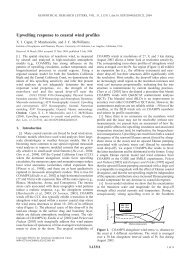
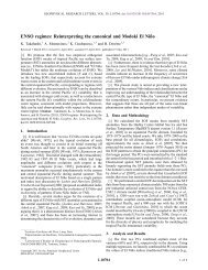
The Nordic Seas refer to the seas lying between Greenland and Norway: the Norwegian,<br />
the Greenland and the Iceland Seas (Fig. 1). Their deep openings with the oceans are the Fram<br />
Strait in the north, the Denmark Strait in the southwest and the Faroe Shetland Channel in the<br />
southeast. Their main hydrological structures are: 1) an eastern boundary current, the<br />
Norwegian Atlantic Current followed by the West Spitsbergen Current, bringing warm and<br />
saline Atlantic Water to the north, 2) a western boundary current, the East Greenland Current<br />
(EGC), carrying waters from the Fram Strait, through the Greenland and Iceland Seas,<br />
towards the Denmark Strait, 3) three cyclonic gyres in the Greenland, Iceland and Norwegian<br />
Seas (Fig. 1; Poulain and Warn-Varnas, 1996; Hansen and Østerhus, 2000).<br />
Figure 1.<br />
Studied area. The large black arrows represent the main hydrodynamic structures: the<br />
East Greenland Current, the Greenland Sea and Iceland Sea gyres. Hydrological sections are<br />
indicated by black white-edged segments. The dashed lines bordering the coasts indicate their<br />
geological type. The white black-striped lines indicate Precambrian formations (ε Nd around –<br />
35), whereas the black white-striped ones indicate basaltic ones (ε Nd around +8). Note the<br />
basaltic nature of the formations bordering the Denmark Strait.<br />
The East Greenland Current flows parallel to the isobaths. It extends from the<br />
continental shelf beyond the bottom of the slope, around 3000 m depth. Its annual mean<br />
transport is 21 ± 3 Sv (1 Sv = 10 6 m 3 .s -1 ; Woodgate et al., 1999). It carries waters of different<br />
origins, some come from the Arctic Ocean, some from the Atlantic Ocean by way of the<br />
Norwegian Atlantic Current and the West Spitsbergen Current, and some from the Greenland<br />
and Iceland gyres (Rudels et al., 1999b).<br />
Seawater samples were collected along four sections within the EGC, above the slope,<br />
between the Fram and Denmark Straits (Fig. 1). A station was also carried out at the mouth of<br />
the Nansen Fjord, in the northwest of Denmark Strait.<br />
3