Technical Note I AlphaShapes range calculation tool - JNCC
Technical Note I AlphaShapes range calculation tool - JNCC
Technical Note I AlphaShapes range calculation tool - JNCC

You also want an ePaper? Increase the reach of your titles
YUMPU automatically turns print PDFs into web optimized ePapers that Google loves.
<strong>Technical</strong> <strong>Note</strong> I<br />
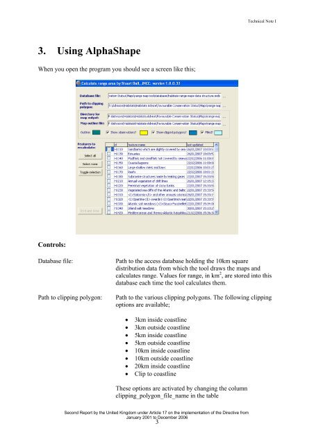
3. Using AlphaShape<br />
When you open the program you should see a screen like this;<br />
Controls:<br />
Database file:<br />
Path to clipping polygon:<br />
Path to the access database holding the 10km square<br />
distribution data from which the <strong>tool</strong> draws the maps and<br />
calculates <strong>range</strong>. Values for <strong>range</strong>, in km 2 , are stored into this<br />
database each time the <strong>tool</strong> calculates them.<br />
Path to the various clipping polygons. The following clipping<br />
options are available;<br />
• 3km inside coastline<br />
• 3km outside coastline<br />
• 5km inside coastline<br />
• 5km outside coastline<br />
• 10km inside coastline<br />
• 10km outside coastline<br />
• 20km inside coastline<br />
• Clip to coastline<br />
These options are activated by changing the column<br />
clipping_polygon_file_name in the table<br />
Second Report by the United Kingdom under Article 17 on the implementation of the Directive from<br />
January 2001 to December 2006<br />
3