Technical Note I AlphaShapes range calculation tool - JNCC
Technical Note I AlphaShapes range calculation tool - JNCC
Technical Note I AlphaShapes range calculation tool - JNCC

Create successful ePaper yourself
Turn your PDF publications into a flip-book with our unique Google optimized e-Paper software.
<strong>Technical</strong> <strong>Note</strong> I<br />
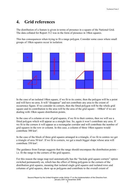
4. Grid references<br />
The distribution of a feature is given in terms of presence in a square of the National Grid.<br />
The data collated for Report 312 was in the form of presence in 10km squares.<br />
This has consequences when trying to fit a <strong>range</strong> polygon. Consider some cases where small<br />
groups of 10km squares occur in isolation:<br />
In the case of an isolated 10km square, if we fit to its centre, then the polygon will be a point<br />
and will have no area. It will “disappear” and not contribute any area to the extent of<br />
occurrence figure. If we consider its corners, then the fitted polygon will be the whole grid<br />
square and its contribution to the area will be the area of the grid square – 100km² if we are<br />
dealing with 10km square distribution points.<br />
In the case of a column or row of grid squares, if we fit to their centres, then we will see a<br />
fitted polygon which will appear as a straight line. So, again it won’t contribute any area. If<br />
we fit to the corners it will appear as a rectangular corridor and will contribute the number of<br />
grid squares in the row or column. In this case, a column of three 10km squares would<br />
contribute 300 km².<br />
In the case of the block of three grid squares ar<strong>range</strong>d in a triangle, if we fit to centres we get<br />
a triangle of area 50 km². If we fit to corners, we get a much bigger shape whose area will<br />
contribute 350 km².<br />
The guidance from Europe suggests that the <strong>range</strong> should encompass the distribution points –<br />
i.e. fit the <strong>range</strong> to the corners of the grid squares.<br />
For this reason the <strong>range</strong> map <strong>tool</strong> automatically has the “Include grid square corners” option<br />
switched permanently on, which has the effect of fitting polygons to the corners of the<br />
distribution grid squares, meaning that isolated single grid squares and isolated rows and<br />
columns of grid squares, show up as polygons and contribute to the overall extent of<br />
Second Report by the United Kingdom under Article 17 on the implementation of the Directive from<br />
January 2001 to December 2006<br />
5