Assessing Conservation Status: The UK Approach - JNCC
Assessing Conservation Status: The UK Approach - JNCC
Assessing Conservation Status: The UK Approach - JNCC

Create successful ePaper yourself
Turn your PDF publications into a flip-book with our unique Google optimized e-Paper software.
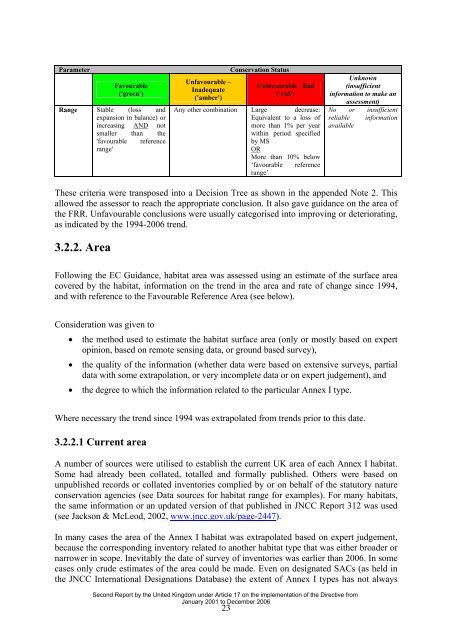
Parameter<br />
Favourable<br />
('green')<br />
Range Stable (loss and<br />
expansion in balance) or<br />
increasing AND not<br />
smaller than the<br />
'favourable reference<br />
range'<br />
Unfavourable –<br />
Inadequate<br />
('amber')<br />
<strong>Conservation</strong> <strong>Status</strong><br />
Unfavourable - Bad<br />
('red')<br />
Any other combination Large decrease:<br />
Equivalent to a loss of<br />
more than 1% per year<br />
within period specified<br />
by MS<br />
OR<br />
More than 10% below<br />
‘favourable reference<br />
range’<br />
Unknown<br />
(insufficient<br />
information to make an<br />
assessment)<br />
No or insufficient<br />
reliable information<br />
available<br />
<strong>The</strong>se criteria were transposed into a Decision Tree as shown in the appended Note 2. This<br />
allowed the assessor to reach the appropriate conclusion. It also gave guidance on the area of<br />
the FRR. Unfavourable conclusions were usually categorised into improving or deteriorating,<br />
as indicated by the 1994-2006 trend.<br />
3.2.2. Area<br />
Following the EC Guidance, habitat area was assessed using an estimate of the surface area<br />
covered by the habitat, information on the trend in the area and rate of change since 1994,<br />
and with reference to the Favourable Reference Area (see below).<br />
Consideration was given to<br />
• the method used to estimate the habitat surface area (only or mostly based on expert<br />
opinion, based on remote sensing data, or ground based survey),<br />
• the quality of the information (whether data were based on extensive surveys, partial<br />
data with some extrapolation, or very incomplete data or on expert judgement), and<br />
• the degree to which the information related to the particular Annex I type.<br />
Where necessary the trend since 1994 was extrapolated from trends prior to this date.<br />
3.2.2.1 Current area<br />
A number of sources were utilised to establish the current <strong>UK</strong> area of each Annex I habitat.<br />
Some had already been collated, totalled and formally published. Others were based on<br />
unpublished records or collated inventories complied by or on behalf of the statutory nature<br />
conservation agencies (see Data sources for habitat range for examples). For many habitats,<br />
the same information or an updated version of that published in <strong>JNCC</strong> Report 312 was used<br />
(see Jackson & McLeod, 2002, www.jncc.gov.uk/page-2447).<br />
In many cases the area of the Annex I habitat was extrapolated based on expert judgement,<br />
because the corresponding inventory related to another habitat type that was either broader or<br />
narrower in scope. Inevitably the date of survey of inventories was earlier than 2006. In some<br />
cases only crude estimates of the area could be made. Even on designated SACs (as held in<br />
the <strong>JNCC</strong> International Designations Database) the extent of Annex I types has not always<br />
Second Report by the United Kingdom under Article 17 on the implementation of the Directive from<br />
January 2001 to December 2006<br />
23