Inside pages without cover - Oklahoma Geological Survey
Inside pages without cover - Oklahoma Geological Survey
Inside pages without cover - Oklahoma Geological Survey

You also want an ePaper? Increase the reach of your titles
YUMPU automatically turns print PDFs into web optimized ePapers that Google loves.
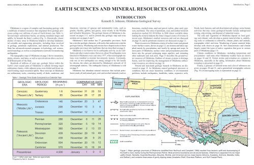
EDUCATIONAL PUBLICATION 9: 2008 Introduction, Page 1<br />
EARTH SCIENCES AND MINERAL RESOURCES OF OKLAHOMA<br />
INTRODUCTION<br />
Kenneth S. Johnson, <strong>Oklahoma</strong> <strong>Geological</strong> <strong>Survey</strong><br />
<strong>Oklahoma</strong> is a region of complex and fascinating geology with<br />
a multitude of natural resources that originated from geologic processes<br />
acting over millions of years of Earth history (see Table 1).<br />
Several major sedimentary basins, set among mountain ranges and<br />
uplifts, lie beneath the State’s surface (Fig. 1). Historically, classic<br />
studies of many areas in <strong>Oklahoma</strong> helped to develop fundamental<br />
scientific and engineering principles, including those involved<br />
in geology, petroleum exploration, and mineral production. The<br />
State has advanced-research programs in hydrology, soil science,<br />
and climatology, as well as a comprehensive network for monitoring<br />
earthquakes.<br />
The topographic map of <strong>Oklahoma</strong> on page 2 shows mountains,<br />
plains, streams, and lakes, as well as spot elevations above sea level<br />
of different parts of the State.<br />
Hundreds of millions of years ago, geologic forces within the<br />
Earth’s crust caused parts of <strong>Oklahoma</strong> to subside forming major<br />
sedimentary basins, while adjacent areas were folded and thrust upward<br />
forming major mountain uplifts. Most outcrops in <strong>Oklahoma</strong><br />
are sedimentary rocks, consisting mainly of shale, sandstone, and<br />
limestone; outcrops of igneous and metamorphic rocks, such as<br />
granite, rhyolite, gabbro, and gneiss, occur mostly in the Wichita<br />
and Arbuckle Mountains. The geologic history of <strong>Oklahoma</strong> is discussed<br />
on <strong>pages</strong> 3–5, and its present-day geologic map and cross<br />
sections are on <strong>pages</strong> 6 and 7.<br />
<strong>Oklahoma</strong>’s land surface has 27 geomorphic provinces. Each<br />
has a similar geologic character, with rocks that underwent a similar<br />
geologic history. Weathering and erosion have shaped rocks in these<br />
geomorphic provinces into landforms that are described on page 8.<br />
<strong>Oklahoma</strong> is not known for its earthquake activity, as are California<br />
and other western states. However, about 50 earthquakes were<br />
detected in <strong>Oklahoma</strong> every year since 1977, when seismograph stations<br />
were installed to monitor low-intensity tremors. Commonly,<br />
only one or two earthquakes are strong enough to be felt locally<br />
by citizens; the others are detected by <strong>Oklahoma</strong>’s network of 10<br />
seismograph stations. The earthquake history of <strong>Oklahoma</strong> is told<br />
on page 9.<br />
<strong>Oklahoma</strong> has abundant mineral resources that include petroleum<br />
(crude oil and natural gas), coal, and nonfuel minerals (such as<br />
limestone, crushed stone, sand and gravel, iodine, glass sand, gypsum,<br />
and shale). The value of petroleum, coal, and nonfuel minerals<br />
production reached $11.99 billion in 2004 (latest available data),<br />
making the mineral industry the State’s largest source of revenue in<br />
recent years. <strong>Oklahoma</strong>’s nonfuel resources and coal are discussed<br />
on page 10, and its petroleum resources are discussed on page 11.<br />
Water resources in <strong>Oklahoma</strong> consist of surface water and ground<br />
water. Surface waters, shown on page 12, are streams and lakes supplied<br />
mainly by precipitation, and locally by springs and seeps. In<br />
most parts of <strong>Oklahoma</strong>, surface water and precipitation percolate<br />
down into the ground recharging major aquifers, and saturating<br />
other sediments and rock units. Page 13 describes the ground-water<br />
resources of <strong>Oklahoma</strong>. Outlines of stream systems or drainage<br />
basins, used for improving the management of <strong>Oklahoma</strong> surfacewater<br />
resources, are shown on page 14.<br />
Natural and man-made geologic hazards in <strong>Oklahoma</strong> are discussed<br />
on page 15. In <strong>Oklahoma</strong>, natural geological processes or<br />
conditions that can cause hazardous conditions or environmental<br />
problems include earthquakes, landslides, radon, expansive soils,<br />
floods, karst features, and salt dissolution/salt springs; some human<br />
activities that may create geological hazards include underground<br />
mining, strip mining, and disposal of industrial wastes.<br />
The soils and vegetation of <strong>Oklahoma</strong> depend on local geology<br />
and climate; soils develop as parent material (that is, underlying<br />
rocks or sediments) is altered by climate, plants and animals,<br />
topographic relief, and time. Weathering of parent material helps<br />
develop soils shown on page 16. Soil characteristics and climate<br />
largely control the types of native vegetation that grow in various<br />
parts of <strong>Oklahoma</strong> (page 17).<br />
Climate conditions in <strong>Oklahoma</strong>—including temperature and<br />
precipitation—and some other <strong>Oklahoma</strong> weather facts are shown<br />
on <strong>pages</strong> 18 and 19. Violent storms and tornadoes are common in<br />
<strong>Oklahoma</strong>, especially in the spring. Information about <strong>Oklahoma</strong><br />
tornadoes is presented on page 19.<br />
Finally, a glossary of selected terms and a list of references are<br />
given on <strong>pages</strong> 20 and 21, and a generalized stratigraphic column<br />
(Fig. 35) of outcropping rocks is represented on page 21.<br />
Table 1. Geologic Time Scale Compared to a Calendar Year<br />
GEOLOGIC<br />
ERA<br />
GEOLOGIC<br />
PERIOD<br />
BEGINNING<br />
(m.y.a. 1 )<br />
COMPARATIVE DATE*<br />
DAY HR MIN<br />
Cenozoic<br />
(”Recent Life”)<br />
Quaternary<br />
Tertiary<br />
1.6<br />
65<br />
December<br />
December<br />
31<br />
26<br />
20<br />
17<br />
53<br />
28<br />
Mesozoic<br />
(”Middle Life”)<br />
Cretaceous<br />
Jurassic<br />
Triassic<br />
146<br />
208<br />
245<br />
December<br />
December<br />
December<br />
20<br />
15<br />
12<br />
3<br />
3<br />
3<br />
47<br />
6<br />
4<br />
Permian<br />
286<br />
December<br />
8<br />
11<br />
28<br />
Pennsylvanian<br />
320<br />
December<br />
5<br />
19<br />
14<br />
Paleozoic<br />
(”Ancient Life”)<br />
Mississippian<br />
Devonian<br />
Silurian<br />
360<br />
409<br />
439<br />
December<br />
November<br />
November<br />
2<br />
28<br />
26<br />
13<br />
19<br />
9<br />
22<br />
49<br />
25<br />
GULF COASTAL PLAIN<br />
Ordovician<br />
504<br />
November<br />
20<br />
15<br />
12<br />
Precambrian<br />
Cambrian<br />
m.y.a. 1 = million years ago. Dates are approximate.<br />
*Prepared by Neil H. Suneson.<br />
570 November<br />
4,500 January<br />
15<br />
1<br />
18<br />
0<br />
24<br />
0<br />
Figure 1. Major geologic provinces of <strong>Oklahoma</strong> (modified from Northcutt and Campbell, 1995) resulted from tectonic uplift and downwarping of<br />
the Earth’s crust, mainly during the Pennsylvanian Period. Most province boundaries are structural features. <strong>Oklahoma</strong> is separated into six major<br />
uplifts (Ozark, Nemaha, Ouachita Mountain, Arbuckle, Wichita, and Cimarron) and six major basins (Arkoma, Anadarko, Ardmore, Marietta, Hollis,<br />
and Dalhart), and contains three areas of gently dipping strata (Anadarko Shelf, Cherokee Platform, and Gulf Coastal Plain).
Page 2, Topographic<br />
EDUCATIONAL PUBLICATION 9: 2008<br />
Contour lines (in feet) are generalized from U.S. <strong>Geological</strong> <strong>Survey</strong> topographic maps<br />
(scale, 1:250,000). Principal meridians and base lines (dotted black lines) are references for<br />
subdividing land into sections, townships, and ranges. Spot elevations ( feet) are given for<br />
select geographic features from detailed topographic maps (scale, 1:24,000). The geographic<br />
center of <strong>Oklahoma</strong> is just north of <strong>Oklahoma</strong> City.<br />
Dimensions of <strong>Oklahoma</strong><br />
Distances: shown in miles (and<br />
kilometers), calculated by Myers<br />
and Vosburg (1964).<br />
Area: 69,919 square miles<br />
(181,090 square kilometers), or<br />
44,748,000 acres (18,109,000<br />
hectares).<br />
Geographic Center of <strong>Oklahoma</strong>:<br />
the point, just north of<br />
<strong>Oklahoma</strong> City, where you could<br />
“balance” the State, if it were<br />
completely flat (see topographic<br />
map).<br />
TOPOGRAPHIC MAP OF OKLAHOMA<br />
Kenneth S. Johnson, <strong>Oklahoma</strong> <strong>Geological</strong> <strong>Survey</strong><br />
This map shows the topographic features of <strong>Oklahoma</strong> using<br />
contour lines, or lines of equal elevation above sea level. The highest<br />
elevation (4,973 ft) in <strong>Oklahoma</strong> is on Black Mesa, in the northwest<br />
corner of the Panhandle; the lowest elevation (287 ft) is where<br />
Little River flows into Arkansas, near the southeast corner of the<br />
State. Therefore, the land surface slopes down to the east and southeast<br />
at an average of about 9 ft per mile; the slope ranges from about<br />
15 ft per mile in the Panhandle to about 4 ft per mile in central and<br />
eastern <strong>Oklahoma</strong>. Spot elevations are shown at each map corner,<br />
at the highest points of several mountain ranges, and at other key<br />
places.<br />
Mountains and streams help define the topography or landscape<br />
of <strong>Oklahoma</strong>. Mountains consist mainly of resistant rocks that were<br />
folded, faulted, and thrust upward over geologic time, whereas<br />
streams continuously erode less-resistant rocks, lowering the landscape<br />
to form hills, broad valleys, and plains. Three principal mountain<br />
ranges (Wichita, Arbuckle, and Ouachita) occur in southern<br />
<strong>Oklahoma</strong>, although mountainous and hilly areas exist in other parts<br />
of the State. The map on page 8 shows the geomorphic provinces<br />
of <strong>Oklahoma</strong> and describes many of the geographic features mentioned<br />
below.<br />
Relief in the Wichita Mountains, mainly in Comanche and Kiowa<br />
Counties, ranges from about 400–1,100 ft. The highest elevation<br />
in the Wichitas is about 2,475 ft, but the best-known peak is Mt.<br />
Scott (2,464 ft). One can easily reach Mt. Scott’s summit by car to<br />
observe spectacular views of the Wichitas and their surroundings.<br />
The Arbuckle Mountains are an area of low to moderate hills in<br />
Murray, Johnston, and Pontotoc Counties. Relief ranges from 100–<br />
600 ft; the highest elevation (about 1,419 ft) is in the West Timbered<br />
Hills in western Murray County. Relief in the Arbuckles is low, but<br />
it is six times greater than any other topographic feature between<br />
Dallas, Texas, and <strong>Oklahoma</strong> City.<br />
The Ouachita (pronounced “Wa-she-tah”) Mountains in southeastern<br />
<strong>Oklahoma</strong> and western Arkansas is a curved belt of forested<br />
ridges and subparallel valleys. Resistant sandstone, chert, and novaculite<br />
form long ridges rising 500–1,500 ft above adjacent valleys<br />
that formed in easily eroded shales. The highest elevation is 2,666<br />
ft on Rich Mountain. Major prominent ridges in the Ouachitas are<br />
the Winding Stair, Rich, Kiamichi, Blue, Jackfork, and Blackjack<br />
Mountains.<br />
Other mountains scattered across the Arkansas River Valley in<br />
eastern <strong>Oklahoma</strong> include the Sans Bois Mountain range and Cavanal,<br />
Sugar Loaf, Poteau, Beaver, Hi Early, and Rattlesnake Mountains.<br />
These mountains typically are broad features rising 300–1,000<br />
ft above wide, rolling plains. The highest summit is Sugar Loaf<br />
Mountain in northeastern Le Flore County with an elevation of<br />
2,568 ft, rising about 2,000 ft above the surrounding plains. The<br />
largest mountainous area in the region is the Sans Bois Mountains,<br />
in northern Latimer and southern Haskell Counties.<br />
The Ozark uplift in northeastern <strong>Oklahoma</strong> is a deeply dissected<br />
plateau consisting of nearly flat-lying limestones, cherts, and sandstones.<br />
The uplift includes parts of the Ozark Plateau, the Brushy<br />
Mountains, and the Boston Mountains. Relief typically is 50–400 ft,<br />
and the highest elevation (about 1,745 ft) is at Workman Mountain<br />
in southeastern Adair County.<br />
The Glass Mountains is an area of “badlands” topography in<br />
north-central Major County. Calling them “mountains” is an exaggeration,<br />
because they are really prominent mesas, buttes, and escarpments<br />
in the Cimarron Gypsum Hills. Local relief ranges from<br />
150–200 ft; the highest elevation is about 1,585 ft.
EDUCATIONAL PUBLICATION 9: 2008 Geologic History, Page 3<br />
GEOLOGIC HISTORY OF OKLAHOMA<br />
Compiled by Kenneth S. Johnson, <strong>Oklahoma</strong> <strong>Geological</strong> <strong>Survey</strong><br />
Due to forces within the Earth, parts of <strong>Oklahoma</strong> in the<br />
geologic past were alternately below or above sea level. Thick<br />
layers of sediments accumulated in shallow seas that <strong>cover</strong>ed<br />
large areas. The sediments were later buried and lithified (hardened<br />
to rock) into marine shales, limestones, and sandstones<br />
over geologic time. In areas near the ancient seas, sands and<br />
clays accumulated as alluvial and deltaic deposits that subsequently<br />
were lithified to sandstones and shales. When the<br />
areas were later elevated above the seas, rocks and sediments<br />
that had been deposited earlier were exposed and eroded. Uplift<br />
was accomplished by the gentle arching of broad areas,<br />
or by mountain building where rocks were intensely folded,<br />
faulted, and thrust upward.<br />
The principal mountain belts, the Ouachita, Arbuckle, and<br />
Wichita Mountains, are in the southern third of <strong>Oklahoma</strong><br />
(Fig. 2). These were the sites of folding, faulting, and uplifting<br />
during the Pennsylvanian Period. The mountain belts exposed<br />
a great variety of geologic structures and brought igneous<br />
rocks and thick sequences of Paleozoic sedimentary strata to<br />
the surface. The uplifts provide sites where one can observe<br />
and collect a great number of fossils, rocks, and minerals (see<br />
Table 1 and Figure 35).<br />
Figure 2. Major geologic provinces of <strong>Oklahoma</strong> (generalized from<br />
page 1, Fig. 1).<br />
The principal sites of sedimentation were elongate basins<br />
that subsided more rapidly than adjacent areas, and received<br />
10,000–40,000 ft of sediment. Major sedimentary basins were<br />
confined to the southern half of <strong>Oklahoma</strong> and include Anadarko,<br />
Arkoma, Ardmore, Marietta, Hollis, and Ouachita Basins;<br />
the Ouachita Basin is the site of today’s Ouachita Mountains,<br />
and was active from Late Cambrian to Early Pennsylvanian. A<br />
smaller basin, the Dalhart Basin, is in the western Panhandle.<br />
The following discussion is modified from Johnson (1971),<br />
Johnson and others (1989), and Johnson (1996). (Note that<br />
many geologic terms are defined in the Glossary of Selected<br />
Terms on <strong>pages</strong> 20 and 21. The stratigraphic column on page<br />
21 illustrates principal <strong>Oklahoma</strong> rock formations and their<br />
ages).<br />
Precambrian and Cambrian Igneous and Metamorphic<br />
Activity<br />
<strong>Oklahoma</strong>’s oldest rocks are Precambrian igneous and<br />
metamorphic rocks that formed about 1.4 billion years ago.<br />
Then in another episode of igneous activity, during the Early<br />
and Middle Cambrian, granites, rhyolites, gabbros, and basalts<br />
formed in southwestern and south-central <strong>Oklahoma</strong>.<br />
Heat and fluids of Cambrian magmas changed older sedimentary<br />
rocks into metamorphic rocks.<br />
Precambrian and Cambrian igneous and metamorphic<br />
rocks underlie all of <strong>Oklahoma</strong> and are the floor or basement<br />
on which younger rocks rest. The top of the basement rocks<br />
typically is ~1,000 ft below the Earth’s surface in the Ozark<br />
Uplift in northeastern <strong>Oklahoma</strong>, except where granite crops<br />
out at Spavinaw, in Mayes County. To the south and southwest,<br />
the depth to basement increases to 30,000–40,000 ft beneath<br />
deep sedimentary basins (Fig. 3). Adjacent to the basins, basement<br />
rocks were uplifted above sea level in two major fault<br />
blocks and are exposed in the Wichita and Arbuckle Mountains.<br />
Igneous rocks and hydrothermal-mineral veins crop out<br />
locally in these mountains.<br />
Figure 3. Generalized contours showing elevation (in thousands of<br />
feet below sea level) of the eroded top of Precambrian and Cambrian<br />
basement rocks in <strong>Oklahoma</strong> and parts of adjacent states.<br />
Late Cambrian and Ordovician Periods<br />
Following a brief period when newly formed Cambrian<br />
igneous rocks and ancient Precambrian rocks were partly<br />
eroded, shallow seas <strong>cover</strong>ed <strong>Oklahoma</strong> during the early Paleozoic<br />
Era. This began a long period of geologic time (515<br />
million years) when parts of <strong>Oklahoma</strong> were alternately inundated<br />
by shallow seas and then raised above sea level. Many<br />
rocks that formed in the various sedimentary environments<br />
contain fossils and diverse mineral deposits.<br />
The sea first invaded <strong>Oklahoma</strong> in the Late Cambrian and<br />
moved across the State from the east or southeast. The Reagan<br />
Sandstone, consisting of sand and gravel eroded from exposed<br />
and weathered basement, was deposited in southern and eastern<br />
parts of <strong>Oklahoma</strong>. Thick limestones and dolomites of the<br />
overlying Arbuckle Group (Late Cambrian and Early Ordovician)<br />
<strong>cover</strong>ed almost the entire State (Fig. 4). The Arbuckle<br />
X X X X X X<br />
X X<br />
X<br />
X X XXX<br />
X<br />
X<br />
X<br />
Figure 4. Principal rock types of Late Cambrian and Early Ordovician<br />
age in <strong>Oklahoma</strong> (explanation of map symbols, below, applies<br />
to Figures 4-18).<br />
EXPLANATION<br />
Group marine sediments increase in thickness southward<br />
from 1,000–2,000 ft in northern shelf areas (Anadarko Shelf<br />
and Cherokee Platform) to about 7,000 ft in the Anadarko and<br />
Ardmore Basins, and in the Arbuckle Mountains. Thick deposits<br />
of black shale, sandstone, and some limestone are present<br />
in the Ouachita province in the southeast. Shallow-marine<br />
limestones, sandstones, and shales characterize Middle and<br />
Late Ordovician rocks throughout most of <strong>Oklahoma</strong> (Fig.<br />
5). Some of the most widespread rock units include Simpson<br />
Group sandstones, Viola Group limestones, and the Sylvan<br />
Shale. These strata are up to 2,500 ft thick in the deep Anadarko<br />
and Ardmore Basins and in the Arbuckle Mountains. Thick<br />
layers of black shale, along with some chert and sandstone<br />
beds, occur in the Ouachita Mountains region to the southeast.<br />
Limestone and other Late Cambrian and Ordovician rocks<br />
exposed in the Arbuckle Mountains and on the flanks of the<br />
Wichita Mountains contain abundant fossils of early marine<br />
X<br />
X<br />
X<br />
X<br />
X<br />
X<br />
X<br />
X<br />
Figure 5. Principal rock types of Middle and Late Ordovician age in<br />
<strong>Oklahoma</strong> (see Fig. 4 for explanation of symbols).<br />
invertebrates such as trilobites, brachiopods, and bryozoans.<br />
Silurian and Devonian Periods<br />
Silurian and Devonian sedimentary rocks in <strong>Oklahoma</strong><br />
(except for deposits in the Ouachita Basin) are limestone and<br />
dolomite overlain by black shale (Fig. 6). The Hunton Group<br />
(latest Ordovician, Silurian, and Early Devonian) is commonly<br />
100–500 ft thick (maximum, 1,000 ft) and was eroded<br />
from northern shelf areas. Invertebrate marine fossils, such<br />
as brachiopods, trilobites, and crinoids, are abundant in the<br />
Hunton in the Arbuckle Mountains and in equivalent strata in<br />
the Ozark Uplift.<br />
After a period of widespread uplift and erosion, the Late<br />
Devonian to earliest Mississippian Woodford Shale was deposited<br />
in essentially the same areas as the Hunton, and northward<br />
into Kansas.<br />
The pre-Woodford erosional surface is a conspicuous unconformity:<br />
500–1,000 ft of strata were eroded over broad<br />
areas, and the Woodford or younger Mississippian units rest<br />
on Ordovician and Silurian rocks. The Woodford typically is<br />
50–200 ft thick, but it is as thick as 600 ft in the Arbuckle<br />
Mountains. The Devonian–Mississippian boundary is placed<br />
at the top of the Woodford because only the uppermost few<br />
feet of Woodford is earliest Mississippian.<br />
In the Ouachita Basin, sandstone and shale of the Blaylock<br />
and Missouri Mountain Formations are Silurian. The Arkansas<br />
Novaculite (chert) is Silurian, Devonian, and Early Mississippian.<br />
These three formations are 500–1,500 ft in total<br />
thickness.<br />
X XXXXX<br />
Figure 6. Principal rock types of Silurian and Devonian age in<br />
<strong>Oklahoma</strong> (see Fig. 4 for explanation of symbols).
Page 4, Geologic History<br />
GEOLOGIC HISTORY OF OKLAHOMA (continued)<br />
Mississippian Period<br />
Shallow seas <strong>cover</strong>ed most of <strong>Oklahoma</strong> during most of<br />
the first half of the Mississippian Period (Fig. 7). Limestone<br />
and chert are the dominant sedimentary rocks in most areas,<br />
and the Arkansas Novaculite occurs in the Ouachita Basin.<br />
Important units are Keokuk and Reeds Spring Formations in<br />
the Ozarks, Sycamore Limestone in southern <strong>Oklahoma</strong>, and<br />
“Mississippi lime” (a term for thick Mississippian limestones)<br />
in the subsurface across most of northern <strong>Oklahoma</strong>. Early<br />
Mississippian limestones, which are the youngest of the thick<br />
carbonate sequences in <strong>Oklahoma</strong>, provide evidence for early<br />
and middle Paleozoic crustal stability.<br />
X X<br />
X<br />
X<br />
X<br />
X<br />
X<br />
X<br />
X X XXX XX XX<br />
X<br />
X<br />
Figure 7. Principal rock types of Mississippian age in <strong>Oklahoma</strong><br />
(see Fig. 4 for explanation of symbols).<br />
Basins in southern <strong>Oklahoma</strong> in the last half of the Mississippian<br />
rapidly subsided, resulting in thick sedimentary<br />
deposits that consist predominantly of shale, with layers of<br />
limestone and sandstone (Fig. 7). Principal Mississippian<br />
formations in southern <strong>Oklahoma</strong> (excluding the Ouachitas)<br />
are the Caney Shale, Goddard Formation, and Springer<br />
Formation (which is partly Early Pennsylvanian): these and<br />
the underlying Sycamore Limestone are 1,500–6,000 ft thick<br />
in the Ardmore and eastern Anadarko Basins and nearby areas.<br />
The greatest thickness of Mississippian strata is 10,000<br />
ft of interbedded sandstone and shale of the Stanley Group<br />
in the Ouachita Basin. Most Mississippian strata in central<br />
and north-central <strong>Oklahoma</strong> were eroded during the Early<br />
Pennsylvanian. In the western Anadarko Basin, Mississippian<br />
strata consist of cherty limestones and shales 3,000 ft thick,<br />
thinning to 200–400 ft east of the Nemaha Uplift.<br />
Mississippian rocks host various fossils and minerals. Marine<br />
limestones and shales in the Arbuckle Mountains and<br />
Ozark Uplift contain abundant invertebrate marine fossils,<br />
such as crinoids, bryozoans, blastoids, and brachiopods. The<br />
Tri-State mining district in northeastern <strong>Oklahoma</strong> (Miami-<br />
Picher area) yielded beautiful crystals of galena, sphalerite,<br />
and calcite.<br />
Pennsylvanian Period<br />
The Pennsylvanian Period was a time of crustal unrest in<br />
<strong>Oklahoma</strong>: both orogeny and basin subsidence in the south;<br />
gentle raising and lowering of broad areas in the north. Uplifts<br />
in Colorado and New Mexico gave rise to the mountain chain<br />
referred to as the Ancestral Rockies. Sediments deposited earlier<br />
in the Wichita, Arbuckle, and Ouachita Uplifts were lithified,<br />
deformed, and uplifted to form major mountains, while<br />
nearby basins subsided rapidly and received sediments eroded<br />
from the highlands. Pennsylvanian rocks are dominantly marine<br />
shale, but beds of sandstone, limestone, conglomerate,<br />
and coal also occur. Pennsylvanian strata, commonly 2,000–<br />
5,000 ft thick in shelf areas in the north, are up to 16,000 ft in<br />
the Anadarko Basin, 15,000 ft in the Ardmore Basin, 13,000 ft<br />
in the Marietta Basin, and 18,000 ft in the Arkoma Basin.<br />
Pennsylvanian rocks contain petroleum reservoirs that<br />
yield more oil and gas than any other rocks in <strong>Oklahoma</strong>, and<br />
they also have large coal reserves in eastern <strong>Oklahoma</strong>. The<br />
Pennsylvanian interests collectors for two reasons. (1) Pennsylvanian<br />
sediments contain abundant invertebrate and plant<br />
fossils in eastern and south-central <strong>Oklahoma</strong>. Invertebrates<br />
include various brachiopods, crinoids, bryozoans, gastropods,<br />
X X X X<br />
X<br />
X<br />
X<br />
X<br />
X<br />
X<br />
X<br />
X X X X X X<br />
X<br />
Figure 8. Principal rock types of Early Pennsylvanian (Morrowan<br />
and Atokan) age in <strong>Oklahoma</strong> (see Fig. 4 for explanation of symbols).<br />
X<br />
X<br />
and bivalves. Plant remains include petrified wood, fossil<br />
leaves, and extensive coal strata. The primary vertebrate fossils<br />
are shark teeth. (2) Pennsylvanian mountain-building caused<br />
the uplift of deeply buried Precambrian through Mississippian<br />
rocks in the Wichita, Arbuckle, Ouachita, and Ozark Uplifts.<br />
The older, fossiliferous and mineral-bearing rocks now are<br />
exposed after the erosion of younger, overlying strata.<br />
The Pennsylvanian Period, subdivided into five epochs of<br />
time, includes (from oldest to youngest): Morrowan (Early),<br />
Atokan, Desmoinesian (Middle), Missourian, and Virgilian<br />
(Late). Orogenies occurred in all five epochs, but each pulse<br />
of mountain building affected different areas by varying degrees.<br />
Folding and uplift of pre-Morrowan rocks characterize<br />
a major Pennsylvanian orogeny, the Wichita orogeny (Morrowan<br />
and early Atokan), resulting in 10,000–15,000 ft of uplift<br />
in the Wichita Mountains and in the Criner Hills south of<br />
Ardmore (Fig. 8). Conglomerate and eroded granite fragments<br />
(locally called granite wash) commonly are present near major<br />
uplifts, and the coarse-grained rocks grade into sandstone<br />
and shale toward the basin centers.<br />
A broad, north-trending arch rose above sea level across<br />
central <strong>Oklahoma</strong> during this time; along its axis, a narrow<br />
belt of fault-block mountains, the Nemaha Uplift, extended<br />
north from <strong>Oklahoma</strong> City into Kansas. A broad uplift also<br />
X X X X X X X<br />
X<br />
X X<br />
X<br />
X<br />
X X X X X X<br />
X<br />
Figure 9. Principal rock types of Middle Pennsylvanian (Desmoinesian)<br />
age in <strong>Oklahoma</strong> (see Fig. 4 for explanation of symbols).<br />
occurred at this time in the Ozark region of northeastern <strong>Oklahoma</strong>.<br />
The Morrowan and Atokan uplift resulted in erosion<br />
that removed all or part of the pre-Pennsylvanian rocks from<br />
the Wichita Mountains, Criner Hills, and central <strong>Oklahoma</strong><br />
Arch. Less erosion occurred in other areas. The most profound<br />
Paleozoic unconformity in <strong>Oklahoma</strong> occurs at the base<br />
of Pennsylvanian rocks, and is recognized everywhere but in<br />
the deeper parts of major basins.<br />
Principal pulses of deformation in the Ouachita Mountains<br />
X X X<br />
X<br />
X<br />
X<br />
X<br />
X<br />
X<br />
Figure 10. Principal rock types of Late Pennsylvanian (Missourian<br />
and Virgilian) age in <strong>Oklahoma</strong> (see Fig. 4 for explanation of<br />
symbols).<br />
area probably started in the Mississippian, and the fold and<br />
thrust belt progressed northward. The pulses, known as the<br />
Ouachita orogeny, stopped by the end of the Desmoinesian<br />
(Fig. 9); the pulses included the northward thrusting of rocks<br />
(perhaps up to 50 mi of thrusting). Uplifting the Ouachita Mountains<br />
above sea level probably occurred during the Desmoinesian;<br />
the Ouachitas remained high into the Permian Period.<br />
Downwarping of the Ouachita Basin shifted northward into<br />
the Arkoma Basin during Atokan and Desmoinesian times, and<br />
deformation ceased after folding and faulting of the Arkoma Basin.<br />
Of special importance in the Arkoma Basin and northeastern<br />
<strong>Oklahoma</strong> are Desmoinesian coal beds formed from plant<br />
matter that had accumulated in swamps. At widely scattered<br />
locations throughout eastern <strong>Oklahoma</strong>, Desmoinesian strata<br />
are well known for fossil trees, wood, and leaves.<br />
The last major Pennsylvanian orogeny, the Arbuckle orogeny,<br />
was a strong compression and uplift during the Virgilian.<br />
The orogeny affected many mountain areas in southern <strong>Oklahoma</strong><br />
and caused prominent folding in the Ardmore, Marietta,<br />
and Anadarko Basins (Fig. 10). Much of the folding, faulting,<br />
and uplift in the Arbuckle Mountains likely occurred in the<br />
late Virgilian. By the end of the Pennsylvanian, <strong>Oklahoma</strong>’s<br />
mountain systems were essentially as they are today, although<br />
subsequent gentle uplift and associated erosion cut deeper<br />
into underlying rocks and greatly reduced the original height<br />
of the mountains.<br />
Permian Period<br />
Following Pennsylvanian mountain building, an Early<br />
Permian (Wolfcampian) shallow inland sea <strong>cover</strong>ed most of<br />
X XX<br />
X X X<br />
EDUCATIONAL PUBLICATION 9: 2008<br />
Figure 11. Principal rock types of Early Permian (Wolfcampian) age<br />
in <strong>Oklahoma</strong> (see Fig. 4 for explanation of symbols).<br />
western <strong>Oklahoma</strong> and the Panhandle, extending north from<br />
west Texas to Nebraska and the Dakotas. Shallow-marine<br />
limestones and gray shales are found in the center of the ancient<br />
seaway (Fig. 11), grading laterally to the east and west<br />
X X X X X X<br />
Figure 12. Principal rock types of Early Permian (Leonardian) age<br />
in <strong>Oklahoma</strong> (see Fig. 4 for explanation of symbols).<br />
into limestones, red shales, and red sandstones (Permian red<br />
beds). During the later Leonardian (Early Permian; Fig. 12),<br />
evaporating sea water deposited thick beds of salt and gypsum<br />
(or anhydrite), such as the Wellington and Cimarron evaporites.<br />
Throughout the Early Permian, the Wichita, Arbuckle,<br />
Ouachita, and Ozark Mountains were still high, supplying
EDUCATIONAL PUBLICATION 9: 2008 Geologic History, Page 5<br />
eroded sand and mud to central and western <strong>Oklahoma</strong>. Alluvial,<br />
deltaic, and nearshore-marine red sandstone and shale<br />
characterize the Early Permian sea margin, interfingering<br />
with gray marine shale, anhydrite, limestone, dolomite, and<br />
salt that typically were deposited toward the center of the sea.<br />
Most Early Permian outcrops are red shales, although thin<br />
limestones and dolomites occur in north-central <strong>Oklahoma</strong>,<br />
X X X X<br />
X X X<br />
Figure 13. Principal rock types of Late Permian (Guadalupian) age<br />
in <strong>Oklahoma</strong> (see Fig. 4 for explanation of symbols).<br />
and crossbedded sandstones are common in central and southcentral<br />
areas. The red color, common in Permian rocks, results<br />
from iron oxides (chiefly hematite) that coat the grains in the<br />
sandstones and shales.<br />
By the Late Permian, the Wichitas were mostly buried by<br />
sediment and the mountains to the east were largely eroded<br />
(Figs. 13-14). Red shale and sandstone typify Guadalupian<br />
rocks, although thick, white gypsum and thin dolomite<br />
beds of the Blaine and Cloud Chief Formations also occur.<br />
Thick salt units occur in the subsurface (Fig. 13). The Rush<br />
Springs Sandstone forms canyons in much of western <strong>Oklahoma</strong>.<br />
Latest Permian (Ochoan) rocks are mostly red-bed<br />
sandstones and shales, but they contain some gypsum and<br />
X<br />
X<br />
X<br />
Figure 14. Principal rock types of Late Permian (Ochoan) age in<br />
<strong>Oklahoma</strong> (see Fig. 4 for explanation of symbols).<br />
dolomite in the west (Fig. 14). The entire Permian sequence is<br />
commonly 1,000–5,000 ft thick, but can be 6,000–6,500 ft in<br />
deeper parts of the Anadarko Basin.<br />
Permian sedimentary rocks in central and western <strong>Oklahoma</strong><br />
contain various fossils and minerals. Fossils, though<br />
rare, include vertebrates (e.g., fish, amphibians, and reptiles),<br />
insects, and a few marine invertebrates. Minerals are more<br />
common and include gypsum (selenite and satin spar), halite<br />
(in subsurface and on salt plains), and rose rocks (barite rose,<br />
the official state rock of <strong>Oklahoma</strong>).<br />
Triassic and Jurassic Periods<br />
Triassic and Jurassic rocks are restricted to the Panhandle<br />
(Fig. 15); most of <strong>Oklahoma</strong> probably was above sea level<br />
at this time. Sandstones, shales, and conglomerates formed<br />
in central and western <strong>Oklahoma</strong> from sediments deposited<br />
mainly in rivers and lakes that drained hills and lowlands of<br />
Permian sedimentary strata. Hills in central Colorado and<br />
X<br />
X<br />
X<br />
X<br />
XX<br />
Figure 15. Principal rock types of Triassic and Jurassic age in<br />
<strong>Oklahoma</strong> (see Fig. 4 for explanation of symbols).<br />
northern New Mexico also supplied some sediments. Triassic<br />
and Jurassic strata in the Panhandle are mostly red and gray,<br />
and are typically 200–700 ft thick.<br />
Southeastern <strong>Oklahoma</strong> probably was an area of low<br />
mountains and hills and was the source of sediment eroded<br />
from the Ouachita Mountains. The Gulf of Mexico almost extended<br />
into <strong>Oklahoma</strong> during the Jurassic. Triassic and Jurassic<br />
fossils in <strong>Oklahoma</strong> include some invertebrates, petrified<br />
wood, and vertebrates such as dinosaurs, crocodiles, turtles,<br />
and fish. In the Panhandle, the Jurassic Morrison Formation is<br />
noteworthy because of its abundant dinosaur bones.<br />
Cretaceous Period<br />
Cretaceous seas <strong>cover</strong>ed all but northeastern and eastcentral<br />
<strong>Oklahoma</strong> (Fig. 16). The ancestral Gulf of Mexico<br />
extended across southeastern <strong>Oklahoma</strong> in the Early Cretaceous,<br />
and shallow seas extended north in the last great inundation<br />
of the western interior of the United States (including<br />
<strong>Oklahoma</strong>) during the Late Cretaceous. Shale, sandstone, and<br />
limestone are about 200 ft thick in the Panhandle and as thick<br />
as 2,000–3,000 ft in the Gulf Coastal Plain (Fig. 16). A major<br />
unconformity is exposed throughout the southeast, where<br />
Figure 16. Principal rock types of Cretaceous age in <strong>Oklahoma</strong><br />
(see Fig. 4 for explanation of symbols).<br />
Cretaceous strata rest on rocks from the Precambrian through<br />
the Permian. Uplift of the Rocky Mountains in the Late Cretaceous<br />
and Early Tertiary caused a broad uplift of <strong>Oklahoma</strong>,<br />
imparting an eastward tilt that resulted in the final withdrawal<br />
of the sea.<br />
Cretaceous marine rocks in southeastern and western<br />
<strong>Oklahoma</strong> contain shark teeth and various invertebrate fossils,<br />
such as oysters, echinoids, and giant ammonites. Nonmarine<br />
Cretaceous strata contain dinosaur bones.<br />
Cretaceous strata have been eroded from almost all parts<br />
of western <strong>Oklahoma</strong> (Fig. 16), except where blocks of Cretaceous<br />
rock (several acres to several square miles wide) have<br />
dropped down several hundred feet into sinkholes formed by<br />
dissolution of underlying Permian salts.<br />
Tertiary Period<br />
The ancestral Gulf of Mexico extended almost to the southeast<br />
corner of <strong>Oklahoma</strong> in the Early Tertiary, and the shoreline<br />
gradually retreated southward through the remainder of<br />
the period. <strong>Oklahoma</strong> supplied some sediments deposited to<br />
the southeast, including gravels, sands, and clays (Fig. 17).<br />
Figure 17. Principal rock types of Tertiary age in <strong>Oklahoma</strong> (see<br />
Fig. 4 for explanation of symbols).<br />
In the Late Tertiary, a thick blanket of sand, silt, clay,<br />
and gravel eroded from the Rocky Mountains was deposited<br />
across the High Plains and farther east by a system of coalescing<br />
rivers and lakes. Some middle and upper parts of<br />
the Tertiary deposits consist of eolian sediment, and some<br />
fresh-water lakes had limestone deposits. Deposits in western<br />
<strong>Oklahoma</strong>, the Ogallala Formation, are 200–600 ft thick; they<br />
may have extended across central <strong>Oklahoma</strong>, thinning eastward.<br />
The nonmarine Ogallala contains fossil wood, snails,<br />
clams, and vertebrates such as horses, camels, rhinoceroses,<br />
and mastodons.<br />
In the northwest corner of the Panhandle, a prominent<br />
layer of Tertiary basaltic lava that flowed from a volcano in<br />
southeastern Colorado caps Black Mesa.<br />
Quaternary Period<br />
The Quaternary Period, the last 1.6 million years of Earth<br />
history, is divided into the Pleistocene Epoch (the “Great Ice<br />
Age”) and the Holocene or Recent Epoch that we live in today.<br />
The boundary between the epochs is about 11,500 years<br />
ago, at the end of the last continental glaciation. During that<br />
time the glaciers extended south only as far as northeastern<br />
Kansas. Major rivers fed by meltwater from Rocky Mountain<br />
glaciers and the increased precipitation associated with<br />
glaciation sculpted <strong>Oklahoma</strong>’s land (Fig. 18). Today’s major<br />
drainage systems originated during the Pleistocene. The rivers’<br />
shifting positions are marked by alluvial deposits left as<br />
terraces, now tens to hundreds of feet above present-day flood<br />
plains.<br />
The Quaternary is characterized as a time when rocks and<br />
loose sediment at the surface are being weathered to soil, and<br />
the soil particles then are carried away to streams and rivers.<br />
In this manner, hills and mountains are eroded, and sediments<br />
are transported to the sea, or are temporarily deposited<br />
in river beds and banks and in lake bottoms. Clay, silt, sand,<br />
Figure 18. Major rivers of <strong>Oklahoma</strong> and principal deposits of Quaternary<br />
age (see Fig. 4 for explanation of symbols)<br />
and gravel from Pleistocene and Holocene rivers and lakes are<br />
typically unconsolidated and 25–100 ft thick. Finding Pleistocene<br />
terraces more than 100–300 ft above modern flood plains<br />
attests to the great amount of erosion and down cutting performed<br />
by major rivers in the last 1.6 million years. Modern<br />
flood plains consist mainly of alluvium deposited during the<br />
Holocene.<br />
Quaternary river-borne sediments decrease in grain size<br />
from west to east across <strong>Oklahoma</strong>; gravel, commonly mixed<br />
with river sands in the west, is abraded so much during transport<br />
that it is almost absent in the east. Eolian sediments characterize<br />
Quaternary deposits in parts of western <strong>Oklahoma</strong>:<br />
sand dunes, mainly on the north sides of major rivers, and<br />
some of the Ogallala (Tertiary) sands and silts, were reworked<br />
by Quaternary winds.<br />
Quaternary sediments locally contain fossil wood, snail<br />
shells, and bones and teeth of land vertebrates (e.g., horses,<br />
camels, bison, mastodons, mammoths). Some fossils were<br />
eroded from the Ogallala and redeposited in the Quaternary.<br />
Horses, camels, mastodons, mammoths and other large animals<br />
lived in <strong>Oklahoma</strong> during the Pleistocene, but they died<br />
out at the end of the Pleistocene and the beginning of the Holocene.
Page 6, Geologic Map<br />
EDUCATIONAL PUBLICATION 9: 2008<br />
EXPLANATION<br />
Sediments and Sedimentary Rocks<br />
Quaternary—Sand, silt, clay, and<br />
gravel in flood plain and terrace deposits<br />
of major rivers. Includes sand<br />
dunes in some terraces and local windblown<br />
sands on Tertiary rocks; generally<br />
25–100 ft thick.<br />
Mississippian—Mostly cherty marine<br />
limestone, 200–3,000 ft thick in the north.<br />
Rocks are mostly marine shale and sandstone<br />
elsewhere; commonly 1,000–6,000<br />
ft thick, but up to 10,000 ft thick in the Ouachita<br />
Mountains.<br />
Tertiary—River and windblown deposits<br />
of sand, clay, gravel, and caliche are<br />
deposited from ancient rivers draining<br />
the Rocky Mountains; generally 200–<br />
600 ft thick.<br />
Cretaceous—Nonmarine sand and clay,<br />
and marine limestone and clay are up<br />
to 3,000 ft thick in the southeast. Marine<br />
sandstone, limestone, and shale are about<br />
200 ft thick in the Panhandle. Scattered<br />
collapsed blocks of marine limestone,<br />
sandstone, and shale are in the Anadarko<br />
basin. Cretaceous is divided into Lower<br />
(K 1<br />
) and Upper (K 2<br />
) units.<br />
Jurassic—Nonmarine, red and gray<br />
shale, sandstone, and conglomerate are<br />
in the Panhandle; generally 100–300 ft<br />
thick.<br />
Silurian–Devonian—Marine limestone<br />
and dolomite, 100–1,000 ft thick, are overlain<br />
by black shale, 50–600 ft thick. In the<br />
Ouachita Mountains, the units, 500–1,500<br />
ft thick, are chert, shale, and sandstone.<br />
Ordovician—Marine limestone and dolomite,<br />
with some sandstone and shale,<br />
thicken from 500–1,500 ft in the north to<br />
about 8,000 ft in the south. In the Ouachita<br />
Mountains, the units are shale, sandstone,<br />
and cherty limestone.<br />
Cambrian—Rocks are marine limestone<br />
and dolomite, with a basal sandstone;<br />
generally 500–2,000 ft thick.<br />
Igneous and Metamorphic Rocks<br />
Triassic—Nonmarine, red and gray<br />
shale and sandstone in the Panhandle<br />
are commonly 200–500 ft thick.<br />
Tertiary—Basaltic lava flow, 50–85<br />
ft thick, in the northwest corner of the<br />
Panhandle; caps Black Mesa.<br />
Permian—Shallow-marine, deltaic, and<br />
alluvial deposits of red sandstone and<br />
shale predominate. Outcrops of white<br />
gypsum are conspicuous, and thick salt<br />
deposits are widespread in the subsurface<br />
in the west; generally 1,000–6,500 ft thick.<br />
Permian is divided into Lower (P 1<br />
) and Upper<br />
(P 2<br />
, P 3<br />
, and P 4<br />
) units; lower part of P 1<br />
is marine red sandstone and shale, with<br />
some thin beds of limestone.<br />
Pennsylvanian—Mostly marine shale,<br />
with interbedded sandstone, limestone,<br />
and coal. Thickness is commonly 2,000–<br />
5,000 ft, but much greater in the Anadarko<br />
Basin (16,000 ft thick), Ardmore Basin<br />
(15,000 ft), Marietta Basin (13,000 ft),<br />
Ouachita Mountains (15,000 ft), and Arkoma<br />
Basin (18,000 ft). Thick conglomerates<br />
occur near the Wichita and Arbuckle<br />
Mountains. Units are divided into Lower<br />
(<br />
1 ), Middle ( 2 ,), and Upper ( 3 ) Pennsylvanian.<br />
Cambrian—Outcrops of granite, rhyolite,<br />
and gabbro occur in the Wichita Mountains;<br />
rhyolite occurs in the Arbuckle<br />
Mountains. Igneous rocks formed from<br />
magma about 525 million years ago;<br />
nearly 20,000 ft thick.<br />
Precambrian—Granite and gneiss (a<br />
metamorphosed igneous rock) crop out<br />
in the Arbuckle Mountains, and granite<br />
crops out in a small area in Mayes<br />
County. Formed about 1.4 billion years<br />
ago, these are the oldest rock outcrops<br />
in <strong>Oklahoma</strong>.<br />
Symbols<br />
Geologic contact<br />
Fault; dotted where concealed by Quaternary<br />
sediments<br />
Line of cross section (see p. 7)<br />
GEOLOGIC MAP OF OKLAHOMA<br />
Kenneth S. Johnson, <strong>Oklahoma</strong> <strong>Geological</strong> <strong>Survey</strong><br />
The geologic map of <strong>Oklahoma</strong> shows rock units<br />
that crop out or are mantled by a thin soil veneer. Quaternary<br />
sediments laid down by streams and rivers locally<br />
overly Precambrian through Tertiary bedrock.<br />
The geologic map helps one understand the age and<br />
character of <strong>Oklahoma</strong>’s rocks in assessing petroleum<br />
reservoirs, mineral deposits, construction sites, engineering<br />
properties, ground-water-aquifer characteristics,<br />
and to remedy environmental problems.<br />
About 99% of all outcrops in <strong>Oklahoma</strong> are sedimentary<br />
rocks. Remaining outcrops are (1) igneous<br />
rocks, mainly in the Wichita and Arbuckle Mountains,<br />
(2) metamorphic rocks in the eastern Arbuckles, and<br />
(3) mildly metamorphosed rocks in the core of the<br />
Ouachita Mountains.<br />
Rocks formed during every geologic period crop<br />
out in <strong>Oklahoma</strong>. About 46% of <strong>Oklahoma</strong> has Permian<br />
rocks exposed at the surface. Other extensive outcrops<br />
are Pennsylvanian (about 25%), Tertiary (11%),<br />
Cretaceous (7%), Mississippian (6%), Ordovician<br />
(1%), and Cambrian (1%); Precambrian, Silurian,<br />
Devonian, Triassic, and Jurassic rocks each are exposed<br />
in less than 1% of <strong>Oklahoma</strong>. These outcrops<br />
do not include the Quaternary river, terrace, and lake<br />
deposits overlying older rocks in <strong>Oklahoma</strong>.<br />
Bedrock geology on this map is derived from Miser<br />
(1954). Quaternary alluvium and terrace deposits<br />
are derived from nine hydrologic atlases of <strong>Oklahoma</strong><br />
prepared jointly by the <strong>Oklahoma</strong> <strong>Geological</strong> <strong>Survey</strong><br />
and the U.S. <strong>Geological</strong> <strong>Survey</strong> (Marcher, 1969;<br />
Marcher and Bingham, 1971; Hart, 1974; Bingham<br />
and Moore, 1975; Carr and Bergman, 1976; Havens,<br />
1977; Bingham and Bergman, 1980; Morton, 1981;<br />
Marcher and Bergman, 1983).
EDUCATIONAL PUBLICATION 9: 2008 Geologic Cross Sections, Page 7<br />
Tertiary<br />
Cretaceous<br />
Cretaceous, Jurassic,<br />
and Triassic<br />
EXPLANATION<br />
Mississippian, Devonian,<br />
and Silurian<br />
Ordovician and Cambrian<br />
(sedimentary rocks)<br />
Cambrian (igneous and<br />
metamorphic rocks)<br />
Vertical exaggeration 10x<br />
Permian<br />
Pennsylvanian<br />
Precambrian<br />
Fault; arrow shows<br />
relative movement<br />
GEOLOGIC CROSS SECTIONS OF OKLAHOMA<br />
Kenneth S. Johnson, <strong>Oklahoma</strong> <strong>Geological</strong> <strong>Survey</strong><br />
Figure 19. Geologic cross sections across the major geologic province map of<br />
<strong>Oklahoma</strong> (generalized from fig.1) : A-A’, B-B’, C-C’, D-D’ and E-E’.<br />
These cross sections show the subsurface configuration<br />
of rock units in <strong>Oklahoma</strong>, depicting the roots<br />
of mountain systems and the great depths of major<br />
sedimentary basins (Fig. 19). Data from the many<br />
petroleum wells drilled deep below the land surface<br />
(<strong>Oklahoma</strong> has more than 460,000 petroleum test<br />
holes) helped to create the cross sections.<br />
By collecting and studying the drill cuttings, cores,<br />
and logs from petroleum tests, water wells, and mineral-exploration<br />
tests, and then integrating all these<br />
data with geologic mapping and geophysical studies,<br />
geologists can determine thickness, depth, and character<br />
of subsurface rock formations in most of <strong>Oklahoma</strong>.<br />
With these data, geologists then can do the<br />
following: (1) more precisely unravel the complex<br />
and exciting geologic history of <strong>Oklahoma</strong>; (2) more<br />
accurately assess location, quality, and quantity of<br />
<strong>Oklahoma</strong>’s petroleum, mineral, and water resources;<br />
and (3) more effectively identify and attempt to remedy<br />
natural geohazards, such as earthquakes, flood-<br />
prone areas, sinkholes, landslides, and expanding<br />
soils, and man-induced conditions such as groundwater<br />
contamination, waste disposal, and mine-land<br />
subsidence.<br />
Figure 19 (to the left) and the Geologic map of<br />
<strong>Oklahoma</strong> on page 6 show the lines of cross section.<br />
The horizontal scales of the cross sections are the<br />
same as for the Geologic Map on page 6: vertical exaggeration<br />
is 10x.
Page 8, Geomorphic Provinces<br />
EDUCATIONAL PUBLICATION 9: 2008<br />
EXPLANATION<br />
Arbuckle Mountains Province<br />
Arbuckle Hills—Low to moderate hills are<br />
chiefly Cambrian to Mississippian limestones.<br />
Steeply dipping strata are complexly<br />
folded and faulted. Scattered sinkholes and<br />
caves occur.<br />
Arbuckle Plains—Gently rolling hills and<br />
plains developed mainly on Precambrian<br />
granites and gently dipping Ordovician limestones.<br />
Scattered sinkholes and caves occur.<br />
Ouachita Mountains Province<br />
Beavers Bend Hills—Moderate to high hills<br />
and ridges are formed by tightly folded Ordovician<br />
through Mississippian sedimentary<br />
rocks.<br />
Ridge and Valley Belt—Long, sinuous<br />
mountain ridges of broadly folded Mississippian<br />
and Pennsylvanian sandstones rise<br />
400–1,200 ft above sub-parallel shale valleys.<br />
Hogback Frontal Belt—Thrust blocks of<br />
steeply dipping Pennsylvanian sandstones<br />
and limestones in hogback ridges rise 500–<br />
1,500 ft above adjacent shale valleys.<br />
Wichita Mountains Province<br />
Granite Mountains Region—Peaks of<br />
Cambrian granite and related igneous rocks<br />
rise 400–1,100 ft above surrounding redbed<br />
plains.<br />
Limestone Hills—Also called Slick Hills,<br />
low to moderate hills of steeply dipping<br />
Cambrian and Ordovician limestones rise<br />
above red-bed plains. Scattered sinkholes<br />
and caves occur.<br />
Other Provinces (alphabetically)<br />
Ardmore Basin—Lowland of folded Mississippian<br />
and Pennsylvanian shales and<br />
sandstones.<br />
Arkansas Hill and Valley Belt—Broad,<br />
gently rolling plains and valleys with scattered<br />
hills, 100–300 ft high, are capped by<br />
Pennsylvanian sandstones.<br />
Black Mesa—Flat-topped erosional remnant<br />
of Tertiary basaltic lava flow that was<br />
extruded from a volcano in Colorado; the<br />
highest point in <strong>Oklahoma</strong> (elevation, 4,973<br />
ft).<br />
Boston Mountains—Deeply dissected plateau<br />
is capped by gently dipping Pennsylvanian<br />
sandstones.<br />
Central Red-Bed Plains—Permian red<br />
shales and sandstones form gently rolling<br />
hills and broad, flat plains.<br />
Cimarron Gypsum Hills—Escarpments<br />
and badlands developed on Permian gypsums<br />
and shales. Locally abundant sinkholes<br />
and caves occur.<br />
Cimarron River Valley—Deeply dissected<br />
valleys in Cimarron County expose flat-lying,<br />
multicolored Mesozoic sandstones and<br />
shales.<br />
Claremore Cuesta Plains—Resistant<br />
Pennsylvanian sandstones and limestones<br />
dip gently westward to form cuestas between<br />
broad shale plains.<br />
Dissected Coastal Plain—Mostly unlithified,<br />
south-dipping Cretaceous sands,<br />
gravels, clays and some limestones form<br />
the Gulf Coastal Plain; slightly dissected by<br />
streams.<br />
Eastern Sandstone-Cuesta Plains—Westdipping<br />
Pennsylvanian sandstones form<br />
cuestas that overlook broad shale plains.<br />
High Plains—Mostly a flat upland surface<br />
on Tertiary and Pleistocene alluvial and<br />
windblown sands. Contains some sand<br />
dunes and playas; deeply dissected along<br />
rivers and major streams.<br />
Mangum Gypsum Hills—Gently rolling<br />
hills, steep bluffs, and badlands developed<br />
on Permian gypsums and shales. Locally<br />
abundant sinkholes and caves occur.<br />
McAlester Marginal Hills Belt—Resistant<br />
Pennsylvanian sandstones cap broad hills<br />
and mountains rising 300–2,000 ft above<br />
wide, hilly plains consisting mostly of shale.<br />
Neosho Lowland—Gently rolling shale lowlands,<br />
with few low escarpments and buttes<br />
capped by Pennsylvanian sandstones and Mississippian<br />
limestones.<br />
Northern Limestone-Cuesta Plains—Thin<br />
Permian limestones cap west-dipping cuestas<br />
rising above broad shale plains.<br />
Ozark Plateau—Deeply dissected plateau<br />
formed in gently dipping Mississippian limestones<br />
and cherts. Locally abundant sinkholes<br />
and caves occur.<br />
Weatherford Gypsum Hills—Gently rolling<br />
hills occur in massive Permian gypsum<br />
beds, 100 ft thick. Locally abundant sinkholes<br />
and caves occur.<br />
Western Red-Bed Plains—Gently rolling<br />
hills of nearly flat-lying Permian red sandstones<br />
and shales.<br />
Western Sand-Dune Belts—Hummocky<br />
fields of grass-<strong>cover</strong>ed, stabilized sand<br />
dunes and some active dunes, occur mainly<br />
on north sides of major rivers. Sand is from<br />
Quaternary alluvium and terrace deposits.<br />
Western Sandstone Hills—Slightly lithified,<br />
nearly flat-lying Permian red sandstones<br />
form gently rolling hills cut by steep-walled<br />
canyons.<br />
GEOMORPHIC PROVINCES<br />
OF OKLAHOMA<br />
Neville M. Curtis, Jr., William E. Ham, and<br />
Kenneth S. Johnson, <strong>Oklahoma</strong> <strong>Geological</strong> <strong>Survey</strong><br />
A geomorphic province is part of the Earth’s<br />
surface where a suite of rocks with similar geologic<br />
character and structure underwent a similar geologic<br />
history, and where the present-day character and<br />
landforms differ significantly from adjacent provinces.<br />
The term used here is the same as “physiographic<br />
province.”<br />
Most outcrops in <strong>Oklahoma</strong> consist of horizontal<br />
or gently dipping sandstones, sands, and shales<br />
of Pennsylvanian, Permian, Cretaceous, and Tertiary<br />
ages (see Geologic Map of <strong>Oklahoma</strong> on page 6).<br />
Some sandstones (mainly in eastern <strong>Oklahoma</strong>) are<br />
well indurated (cemented), but in most other parts of<br />
<strong>Oklahoma</strong> they are not so well indurated and erode<br />
easily; therefore, much of <strong>Oklahoma</strong> is gently rolling<br />
hills and broad, flat plains. Elsewhere, erosion-resistant<br />
layers of sandstone, limestone, or gypsum form<br />
protective caps on buttes, cuestas, escarpments, and<br />
high hills.<br />
Among the more impressive geomorphic provinces<br />
are several mountain belts and uplifts in southern<br />
and northeastern <strong>Oklahoma</strong>. In the southern third of<br />
<strong>Oklahoma</strong>, well-indurated rocks were folded, faulted,<br />
and uplifted forming the Wichita, Arbuckle, and Ouachita<br />
Mountains. The mountains and high hills, the<br />
resistant rock units, and the complex geology of these<br />
three provinces contrast sharply with <strong>Oklahoma</strong>’s<br />
typical rolling hills and broad plains. In hilly, wooded<br />
areas of the Ozark Plateau and Boston Mountains in<br />
northeastern <strong>Oklahoma</strong>, streams and rivers created<br />
sharp relief locally by cutting down into resistant<br />
limestones and sandstones.
EDUCATIONAL PUBLICATION 9: 2008 Earthquakes, Page 9<br />
Table 2. Modified Mercalli (MM) Earthquake-Intensity<br />
Scale Table (modified 2. Modified from Wood Mercalli and (MM) Neumann, Earthquake-Intensity<br />
1931)<br />
Scale (modified from Wood and Neumann, 1931)<br />
EXPLANATION<br />
Semipermanent field station:<br />
Semipermanent field station:<br />
includes station abbreviation<br />
includes station abbreviation<br />
(1897-2002)<br />
Date<br />
Table Table 3. <strong>Oklahoma</strong> 3. <strong>Oklahoma</strong> Earthquakes Earthquakes with with Magnitudes >4.0<br />
Origin time Origin time<br />
Nearest Nearest<br />
Intensity Intensity Magnitudes c<br />
Date<br />
(UTC) a (UTC) a<br />
County County town town<br />
MM MM b b<br />
3Hz 3Hz bLg bLg DUR<br />
VII<br />
VII<br />
IV<br />
IV<br />
VII<br />
VII<br />
V<br />
V<br />
VI<br />
VI<br />
VI<br />
VI<br />
VI<br />
VI<br />
VII<br />
VII<br />
V<br />
V<br />
VI<br />
VI<br />
V<br />
V<br />
VI<br />
VI<br />
Lat. Lat.<br />
°N °N<br />
Long. Long.<br />
°W °W<br />
EARTHQUAKES OF OKLAHOMA<br />
Kenneth V. Luza, <strong>Oklahoma</strong> <strong>Geological</strong> <strong>Survey</strong><br />
In <strong>Oklahoma</strong>, ground motion due to earthquakes is recorded at 10 widely<br />
separated locations. The main recording and research facility, station TUL, is<br />
near Leonard, <strong>Oklahoma</strong>, in Tulsa County. About 50 minor earthquakes are<br />
located in <strong>Oklahoma</strong> each year, but only one or two typically are felt. Before<br />
1962, only 59 <strong>Oklahoma</strong> earthquakes were known either from historical accounts<br />
or from seismograph stations in other states. The first seismographs<br />
were installed in 1961. From 1962 through 1976, 70 earthquakes were added<br />
to the earthquake data base. By 1977, 9 seismograph stations throughout <strong>Oklahoma</strong><br />
were detecting and locating earthquakes. Over 1,550 earthquakes were<br />
located in <strong>Oklahoma</strong> from 1977 through 2002.<br />
Earthquake Size<br />
The most common ways to express the size of earthquakes are by their intensity<br />
and magnitude. The intensity, reported on the Modified Mercalli (MM)<br />
Scale, is a subjective measure based on eyewitness accounts (Table 2). Intensities<br />
are rated on a 12-level scale ranging from barely perceptible (I) to total destruction<br />
(XII). The scale is used to evaluate the size of historical earthquakes.<br />
Earthquake magnitude is related to the seismic energy released at the hypocenter,<br />
and based on the amplitude of earthquake waves recorded on instruments<br />
that have a common calibration. To determine the size of earthquakes, the<br />
<strong>Oklahoma</strong> <strong>Geological</strong> <strong>Survey</strong> uses three magnitude types: mbLg (similar to<br />
Richter magnitude), m3Hz, and mDUR (Lawson and Luza, 1995).<br />
Historical Earthquakes<br />
The New Madrid, Missouri, earthquakes of 1811 and 1812 probably are the<br />
earliest historical earthquake tremors felt in present-day southeast <strong>Oklahoma</strong>.<br />
Prior to statehood, the earliest documented earthquake epicenter in <strong>Oklahoma</strong><br />
was on October 22, 1882. The earthquake, although it cannot be located precisely,<br />
produced MM VIII intensity effects near Fort Gibson, Indian Territory.<br />
The earliest documented locatable earthquake occurred near Jefferson in Grant<br />
County on December 2, 1897 (Stover and others, 1981).<br />
On April 9, 1952, the largest known <strong>Oklahoma</strong> earthquake (with the possible<br />
exception of the 1882 Fort Gibson earthquake) occurred near El Reno in<br />
Canadian County (Table 3). The magnitude-5.5 earthquake caused a 50-ft-long<br />
crack in the State Capitol Office Building in <strong>Oklahoma</strong> City, and was also felt<br />
in Austin, Texas, and Des Moines, Iowa. The earthquake was felt in an area<br />
of 140,000 square miles, and produced MM VII–IX intensity effects near the<br />
epicenter.<br />
Earthquake Distribution<br />
Typical <strong>Oklahoma</strong> earthquake magnitudes range from 1.8 to 2.5, with shallow<br />
focal depths (less than 3 miles). Earthquakes have occurred in 72 <strong>Oklahoma</strong><br />
counties; Washington, Nowata, Craig, Adair, and Jackson Counties have had no<br />
known earthquakes. Over 880 earthquake events have occurred in the Anadarko<br />
Basin since 1897. The majority are concentrated in a 25- by 37-mile area nearly<br />
parallel to a deep, subsurface fault zone in west McClain and Garvin Counties<br />
and southeast Grady County. Over 90% of the earthquakes in this zone have<br />
occurred since 1977. The apparent increase in seismic activity is due, in part, to<br />
improved earthquake detection. Only a few earthquakes have occurred in the<br />
shelf and deeper portions of the basin.<br />
Before 1976, over half of <strong>Oklahoma</strong> earthquakes were located in Canadian<br />
County; most occurred in the El Reno vicinity, which also is the site of<br />
numerous earthquakes since 1908. Canadian County still experiences smallmagnitude<br />
earthquakes each year. Another principal area of seismic activity<br />
is in Love, Carter, and Jefferson Counties. The first reported earthquake there<br />
occurred in 1974; several small earthquakes have been felt in the region since<br />
then. The Arkoma Basin in southeast <strong>Oklahoma</strong> is also seismically active.<br />
About 90% of all earthquakes there were located with seismometers. Typical<br />
magnitudes are less than 2.5.
Page 10, Mineral Deposits and Resources<br />
EDUCATIONAL PUBLICATION 9: 2008<br />
EXPLANATION<br />
Area underlain by bituminous<br />
coal or lignite<br />
Mine (10)<br />
Principal outcrop area<br />
Pit (4)<br />
Principal outcrop area<br />
Quarry (9)<br />
Principal outcrop area<br />
Quarry (22)<br />
Area of many abandoned mines<br />
Principal outcrop area<br />
Quarry/Mine (79) Lime plant (1)<br />
Area underlain by salt<br />
Plant (2)<br />
Salt plain<br />
MINERAL DEPOSITS AND RESOURCES OF OKLAHOMA<br />
(Exclusive of Oil and Gas) Kenneth S. Johnson, <strong>Oklahoma</strong> <strong>Geological</strong> <strong>Survey</strong><br />
<strong>Oklahoma</strong>’s mineral resources, produced in all 77 counties, include:<br />
nonfuel minerals such as limestone, gypsum, salt, clays, iodine,<br />
and sand and gravel; coal; and petroleum (crude oil and natural<br />
gas). In recent years, the mineral industry has been the State’s greatest<br />
source of revenue. In 2004, the combined value of petroleum,<br />
coal, and nonfuel minerals produced in <strong>Oklahoma</strong> was about $12<br />
billion; it reached a high of nearly $13 billion in 1982 and 1984.<br />
Total production of all minerals since statehood (1907) is valued at<br />
$231 billion.<br />
Although <strong>Oklahoma</strong> petroleum production accounts for about<br />
95% of <strong>Oklahoma</strong>’s annual mineral output, nonfuel minerals and<br />
coal represent a significant part of the State’s current economy and<br />
an important source of future wealth. The total estimated value of<br />
nonfuel-mineral and coal production in <strong>Oklahoma</strong> during 2004 was<br />
$558 million. Leading commodities produced during 2004 were<br />
crushed stone (valued at $195 million), portland cement (production<br />
data withheld), construction sand and gravel ($54 million), coal ($51<br />
million), industrial sand and gravel ($32 million), gypsum ($21 million),<br />
and iodine ($16 million). Other commodities now produced<br />
in <strong>Oklahoma</strong>, or for which there are current mining permits, include<br />
clays and shale, salt, lime, granite, rhyolite, dolomite, sandstone,<br />
volcanic ash, and tripoli. Deposits and resources that are not mined<br />
now, or with no current mining permits, include asphalt, lead, zinc,<br />
copper, iron, manganese, titanium, and uranium. <strong>Oklahoma</strong> ranked<br />
first in U.S. production of gypsum and iodine (<strong>Oklahoma</strong> is the only<br />
producer of iodine in the U.S.); second in tripoli production; fourth<br />
in feldspar; seventh in common clays produced; and eighth in industrial<br />
sand and gravel.<br />
Important reserves of certain high-purity minerals suitable as raw<br />
materials for manufacture of various chemicals include high-calcium<br />
limestone, high-purity dolomite, and glass sand in south-central<br />
and eastern parts of <strong>Oklahoma</strong>; gypsum and salt are widespread in<br />
western <strong>Oklahoma</strong>. Under proper economic conditions, the abundance<br />
and purity of these minerals would enable the manufacture of<br />
caustic soda, soda ash, chlorine, sulfur, sulfuric acid, lime, sodium<br />
silicate, and other chemicals. Oil, natural gas, and water, which are<br />
needed to manufacture these products, are plentiful in most of <strong>Oklahoma</strong>,<br />
and bituminous coal is abundant in eastern <strong>Oklahoma</strong>.<br />
Historically, lead, zinc, and copper were very important to the<br />
economy of <strong>Oklahoma</strong>, although metals are no longer produced.<br />
The Miami-Picher area of Ottawa County was a center for lead-zinc<br />
production in the world-famous Tri-State Mining District of northeastern<br />
<strong>Oklahoma</strong>, southeastern Kansas, and southwestern Missouri.<br />
Ottawa County’s underground mines produced approximately<br />
1.3 million tons of lead and 5.2 million tons of zinc between 1891<br />
and 1970, when the last mine was closed. <strong>Oklahoma</strong> led the nation<br />
in zinc production almost every year from 1918 through 1945. In the<br />
southwest corner of the State, near Altus (Jackson County), a surface<br />
copper mine produced approximately 1.88 million tons of ore<br />
between 1964 and 1975. A decline in copper prices and an increase<br />
in production costs caused the mine to close.
EDUCATIONAL PUBLICATION 9: 2008 Oil and Gas, Page 11<br />
EXPLANATION<br />
*<br />
*<br />
*<br />
At the end of 2000, <strong>Oklahoma</strong> had 70 gasprocessing<br />
plants concentrated in the gasproducing<br />
western half of the State. These<br />
have a capacity of 4,197 million cubic feet<br />
per day and handle 2,676 million cubic feet<br />
per day of natural gas. They produce an<br />
average of 7.85 million gallons of liquid<br />
products per day, which on an annualized<br />
basis is about 68 million barrels.<br />
*Outlines of oil and gas fields and areas of oil and gas<br />
production based on Boyd (2002).<br />
There were five major petroleum refineries<br />
operating in <strong>Oklahoma</strong> at the end of<br />
2000, each with a daily capacity of over<br />
over 45,000 barrels. An additional five,<br />
much smaller facilities, are present that<br />
employ as few as 8 workers. These refineries<br />
produce a wide range of products<br />
including propane, gasoline, diesel, jet<br />
fuel, fuel oil, lubricants, petroleum coke,<br />
sulfur, and asphalt. They have a<br />
combined crude-oil capacity of about<br />
450,000 barrels (18,900,000 gallons) per<br />
day.<br />
There are many facilities in <strong>Oklahoma</strong><br />
that produce chemicals derived from<br />
petroleum, and these are commonly<br />
associated with refineries. The 17<br />
plants in the State that employed at<br />
least 10 workers at the end of 2000 are<br />
shown on the map. These produce a<br />
variety of products, including lubricants,<br />
fertilizer, plastics, petroleum coke, and<br />
carbon black.<br />
OIL AND GAS PRODUCTION<br />
AND FACILITIES OF OKLAHOMA<br />
Dan T. Boyd, <strong>Oklahoma</strong> <strong>Geological</strong> <strong>Survey</strong><br />
Oil and gas are organic compounds dominantly composed of<br />
hydrogen and carbon, hence the name “hydrocarbons.” They form<br />
from microscopic organisms, deposited with sediments that later<br />
become sedimentary rocks after deep burial in a geologic basin.<br />
Temperature and pressure increase with depth of burial, and over<br />
geologic time the organic remains convert to oil and gas through<br />
thermal alteration. The oil and gas migrate from fine-grained source<br />
rocks into coarser, more permeable rocks. Because oil and gas are<br />
buoyant, they migrate upward until impermeable rocks block the<br />
path of movement. Such a barrier (seal) blocks further migration;<br />
the geometry of the seal is a factor that determines the size of the hydrocarbon<br />
trap in which oil and gas accumulate. Most <strong>Oklahoma</strong> oil<br />
and gas production comes from sedimentary basins of Pennsylvanian<br />
age (287–320 million years ago). Reservoirs across <strong>Oklahoma</strong>,<br />
however, range from Precambrian (more than 570 million years ago)<br />
to Cretaceous (65–146 million years ago).<br />
Native Americans in <strong>Oklahoma</strong> dis<strong>cover</strong>ed and used oil from<br />
seeps before European settlers arrived. The first commercial (profitable)<br />
oil well was drilled in 1896 near Bartlesville, in present-day<br />
Washington County. Oil production increased rapidly after 1900,<br />
providing the impetus for statehood in 1907. Annual production<br />
peaked at 278 million barrels in 1927 with many intermediate highs<br />
and lows since then. Statewide production declined continuously<br />
since 1984, near the end of the last major drilling boom. Cumulative<br />
oil production in <strong>Oklahoma</strong> is about 14.7 billion barrels, with a<br />
2005 production rate of 167,000 barrels per day. In 2005 the average<br />
production rate per oil well in <strong>Oklahoma</strong> was just more than 2 barrels<br />
per day, highlighting the maturity of the industry. Consumption<br />
of petroleum products in <strong>Oklahoma</strong> is about 50% greater than its<br />
production of crude oil.<br />
<strong>Oklahoma</strong>’s 2005 annual crude-oil production of about 61 million<br />
barrels represents slightly more than 3% of the national output<br />
and makes the State the fifth largest crude-oil producer in the country.<br />
This production rate represents one-quarter of the 1927 peak. At<br />
an average price of $50 per barrel, annual production has a value of<br />
more than $3.0 billion. At the end of 2005, the U.S. Department of<br />
Energy placed <strong>Oklahoma</strong>’s proved oil reserves at 588 million barrels.<br />
Natural gas, almost always associated with oil, was considered<br />
a nuisance or drilling hazard in the early days. Exploration did not<br />
target natural gas widely in <strong>Oklahoma</strong> until the second half of the<br />
twentieth century. Cumulative gas production through 2005 is 95.6<br />
trillion cubic feet; annual production peaked in 1990 at about 6.2<br />
billion cubic feet per day. In 2005, production averaged about 4.4<br />
billion cubic feet per day. <strong>Oklahoma</strong>’s natural-gas industry is relatively<br />
young. Drilling in <strong>Oklahoma</strong>, especially for exploration, is<br />
dominated now by wells with gas objectives. Gas production is<br />
likely to remain strong well into the 21st century. In 2005, annual<br />
natural-gas production was about 1.6 trillion cubic feet, about 8%<br />
of U.S. production, making <strong>Oklahoma</strong> the third largest U.S. gas<br />
producer. The 2005 production rate is about two-thirds the peak<br />
reached in 1990. At a market price of about $5 per thousand cubic<br />
feet, the 2005 volume has a value of nearly $8 billion. At the end of<br />
2005, the U.S. Department of Energy reported proved gas reserves<br />
in <strong>Oklahoma</strong> at 17.1 trillion cubic feet. Statewide gas production is<br />
about three times consumption.<br />
Data cited here are from records compiled and maintained by the<br />
<strong>Oklahoma</strong> Corporation Commission, the <strong>Oklahoma</strong> Department of<br />
Commerce, and the Energy Information Administration of the U.S.<br />
Department of Energy.
Page 12, Rivers, Streams, and Lakes<br />
EDUCATIONAL PUBLICATION 9: 2008<br />
EXPLANATION<br />
Scenic River; number corresponds to name in text<br />
Salt Plain; number corresponds to name in text<br />
Table 4. Major lakes and reservoirs in <strong>Oklahoma</strong><br />
Lake Area Drainage Area a Capacity Location<br />
Normal Pool<br />
Normal Pool<br />
(acres) (square miles) (acre-feet) County/Counties<br />
Eufaula 105,500 47,522 2,314,600 McIntosh; Pittsburg; Haskell<br />
Texoma 88,000 39,719 2,643,300 Love; Marshall; Bryan; Johnston<br />
Grand Lake O’ the 46,500 10,298 1,672,000 Delaware; Ottawa; Mayes<br />
Cherokees<br />
Robert S. Kerr 43,800 147,756 525,700 Haskell; Sequoyah; Le Flore<br />
Oologah 29,460 4,339 553,400 Rogers; Nowata<br />
Keystone 23,610 74,506 557,600 Osage; Pawnee; Creek; Tulsa<br />
Fort Gibson 19,900 12,492 365,200 Wagoner; Cherokee; Mayes<br />
Kaw 17,040 46,530 428,600 Kay; Osage<br />
Broken Bow 14,200 754 918,070 McCurtain<br />
Sardis 13,610 275 274,330 Pushmataha; Latimer<br />
Hugo 13,250 1,709 157,600 Choctaw<br />
Tenkiller 12,900 1,610 654,100 Cherokee; Sequoyah<br />
Webbers Falls 11,600 97,033 170,100 Muskogee<br />
Hudson 10,900 11,533 220,300 Mayes<br />
Skiatook 10,190 354 322,700 Osage<br />
Waurika 10,100 562 203,100 Jefferson; Stephens; Cotton<br />
Foss 8,880 1,496 256,220 Custer<br />
Great Salt Plains 8,690 3,200 31,420 Alfalfa<br />
Canton 7,910 12,483 111,310 Blaine; Dewey<br />
Wister 7,333 993 62,360 Le Flore<br />
a<br />
Data from the <strong>Oklahoma</strong> Water Resources Board (1990).<br />
RIVERS, STREAMS, AND LAKES OF OKLAHOMA<br />
Kenneth S. Johnson and Kenneth V. Luza, <strong>Oklahoma</strong> <strong>Geological</strong> <strong>Survey</strong><br />
A stream is any body of running water, large or small, that flows under<br />
the influence of gravity toward lower elevations in a relatively narrow,<br />
clearly defined channel. Each major drainage system in <strong>Oklahoma</strong> consists<br />
of a principal river, with many smaller tributary rivers, streams, and<br />
creeks funneling water to the main course.<br />
The condition and flow rates of <strong>Oklahoma</strong> streams are temporary in<br />
terms of geologic time. Stream positions shift as they cut deeper channels<br />
into their banks, while their tributaries erode nearby uplands. Major<br />
drainage systems of today were established during the Pleistocene (the<br />
last 1.6 million years). Streams flowed across <strong>Oklahoma</strong> for millions of<br />
years before finally carving out today’s major drainage basins. The positions<br />
of earlier streams are marked now by alluvial deposits remaining as<br />
stream terraces, high above the flood plains of today’s streams that are<br />
eroding deeper into underlying rocks.<br />
All major streams in <strong>Oklahoma</strong> have broad, sand-filled channels with<br />
active water courses occupying a small portion of the river bed or flood<br />
plain. These broad, sand-filled channels reflect large changes in discharge<br />
(floods) that occur from time to time. Many man-made dams on major<br />
streams and tributaries, however, have decreased flooding frequency and<br />
magnitude. As a result, active water courses gradually are stabilizing<br />
within their broad stream beds.<br />
All <strong>Oklahoma</strong> streams are within two major drainage basins: the Red<br />
River basin, and the Arkansas River basin (see page 14). The two rivers<br />
and their many tributaries flow into <strong>Oklahoma</strong> from neighboring states,<br />
while all surface water from <strong>Oklahoma</strong> flows into Arkansas, via the Red,<br />
Arkansas, and Little Rivers, and Lee Creek. Major rivers and tributaries<br />
flow mainly east and southeast across <strong>Oklahoma</strong>.<br />
Six scenic rivers flow in eastern <strong>Oklahoma</strong> and several natural salt<br />
plains and saline rivers are present in the west. Five scenic rivers in the<br />
Arkansas River drainage are in Adair, Cherokee, Delaware, and Sequoyah<br />
Counties in the Ozark Plateau. They include parts of the Illinois River<br />
(1, see map), and Flint (2), Baron Fork (3), Little Lee (4), and Lee (5)<br />
Creeks. The upper part of Mountain Fork (6), which flows into Broken<br />
Bow Lake in the Ouachita Mountains in McCurtain County, is in the Red<br />
River drainage.<br />
Natural salt plains occur along some rivers where natural brines seep<br />
to the surface. In the Arkansas River drainage, Great Salt Plains (1) on<br />
Salt Fork is the largest salt flat <strong>cover</strong>ing about 25 square miles. Others in<br />
northwestern <strong>Oklahoma</strong> are Big Salt Plain (2) and Little Salt Plain (3) on<br />
the Cimarron River, and Ferguson Salt Plain (4) in Blaine County. Salt<br />
plains in the Red River drainage are Boggy Creek Salt Plain (5) on North<br />
Fork Red River; Kiser (6), Robinson (7), and Chaney (Salton) (8) Salt<br />
Plains on Elm Fork in north Harmon County; and Jackson County Salt<br />
Plain (9). Downstream in both drainage basins, fresh-water inflow dilutes<br />
saline river waters, making the water usable for municipalities, livestock,<br />
and industrial purposes before reaching Keystone Lake or Lake Texoma.<br />
There are many lakes and reservoirs in <strong>Oklahoma</strong>; most are manmade,<br />
created by damming streams for flood control, water supply, recreation,<br />
fish, wildlife, and hydroelectric power. Lakes on the Arkansas<br />
and Verdigris Rivers aid in navigation along the McClellan-Kerr Navigation<br />
System. Major lakes are formed behind dams built by the U.S.<br />
Army Corps of Engineers, U.S. Bureau of Reclamation, and the Grand<br />
River Dam Authority. Various state and federal agencies, cities, and other<br />
entities own and operate large lakes. Farmers and landowners have built<br />
many smaller lakes and ponds. Table 4 lists the 20 <strong>Oklahoma</strong> lakes with<br />
the largest surface areas.<br />
A series of oxbow and playa lakes are the only natural lakes in <strong>Oklahoma</strong><br />
(<strong>Oklahoma</strong> Water Resources Board, 1990). Typically crescentshaped,<br />
oxbow lakes occupy abandoned channels of meandering streams<br />
and occur mainly in flood plains of the Red, Arkansas, Washita, North<br />
Canadian, and Verdigris Rivers in central and eastern <strong>Oklahoma</strong>. <strong>Oklahoma</strong><br />
has 62 oxbow lakes <strong>cover</strong>ing at least 10 acres each; the largest,<br />
near Red River in McCurtain County, <strong>cover</strong>s 272 acres (<strong>Oklahoma</strong> Water<br />
Resources Board, 1990).<br />
Playa lakes form in shallow, saucer-like depressions scattered across<br />
the semiarid High Plains in northwestern <strong>Oklahoma</strong> and the Panhandle.<br />
Playa lakes have no outflow, holding water during and after rainy seasons<br />
before evaporating, or losing water by infiltrating into the ground. <strong>Oklahoma</strong><br />
has about 600 of these intermittent or ephemeral playa lakes, but<br />
only a few persist year-round (<strong>Oklahoma</strong> Water Resources Board, 1990).
EDUCATIONAL PUBLICATION 9: 2008 Principal Ground-Water Resources, Page 13<br />
EXPLANATION<br />
MAP<br />
SYMBOL<br />
AQUIFER<br />
PRINCIPAL<br />
LITHOLOGY<br />
COMMON YIELD<br />
(gallons per minute)<br />
GENERAL MINERAL<br />
CONTENT OF WATER<br />
Quaternary alluvium and<br />
terrace deposits (Q) 1<br />
Sand, silt, and gravel<br />
10–500<br />
(up to 2,000)<br />
Low to high (alluvium);<br />
low (terraces)<br />
Ogallala Formation (T)<br />
Sand, silt, and gravel<br />
25–1,500<br />
Low<br />
Antlers Sandstone<br />
(Trinity Group) (K 1<br />
)<br />
Sandstone and sand<br />
10–50<br />
Low to moderate<br />
Elk City Sandstone (P 4<br />
)<br />
Sandstone<br />
25–300<br />
Low<br />
Rush Springs Sandstone<br />
and Marlow Formation (P 3<br />
)<br />
Sandstone<br />
25–300<br />
Low to moderate; moderate<br />
to high in north<br />
Blaine Formation and<br />
Dog Creek Shale (P 2<br />
)<br />
Gypsum and dolomite<br />
300–2,500<br />
Moderate to high<br />
Cedar Hills Sandstone (P 2<br />
)<br />
Sandstone<br />
150–300<br />
Low to high<br />
Garber Sandstone and<br />
Wellington Formation (P 1<br />
)<br />
Sandstone<br />
25–400<br />
Low to moderate<br />
Oscar Group, area a (P 1<br />
)<br />
Sandstone<br />
25–50<br />
Low to moderate<br />
Oscar Group, area b (P 1<br />
)<br />
Sandstone<br />
50–180<br />
Low to moderate<br />
Vamoosa Formation and<br />
Ada Group (P 3<br />
)<br />
Sandstone<br />
25–150<br />
Low to moderate<br />
Noxie Sandstone (P 3<br />
)<br />
Sandstone<br />
10–50<br />
Low to moderate<br />
Keokuk and Reeds Spring<br />
Formations (“Boone”) (M)<br />
Limestone and cherty<br />
limestone<br />
5–50<br />
Low<br />
Arkansas Novaculite and<br />
Bigfork Chert (M, D, S, O)<br />
Fractured chert and<br />
novaculite<br />
10–50<br />
Low<br />
Roubidoux, Gasconade, and<br />
Eminence Formations (O, )<br />
Cherty dolomite and<br />
sandstone<br />
50–250<br />
Low to moderate<br />
Simpson and Arbuckle<br />
Groups (O, )<br />
Limestone, dolomite,<br />
and sandstone<br />
25–600<br />
Low<br />
Arbuckle and Timbered<br />
Hills Groups (O, )<br />
Limestone, dolomite,<br />
and some sandstone<br />
25–600<br />
Low to moderate<br />
1<br />
Symbols in parentheses indicate geologic age, as shown on the Geologic Map of <strong>Oklahoma</strong> on page 6.<br />
PRINCIPAL GROUND-WATER RESOURCES OF OKLAHOMA<br />
Kenneth S. Johnson, <strong>Oklahoma</strong> <strong>Geological</strong> <strong>Survey</strong><br />
An “aquifer” consists of rocks and sediments saturated with good- to<br />
fair-quality water, and that is sufficiently permeable to yield water from<br />
wells at rates greater than 25 gal/min (gallons per minute). This map shows<br />
the distribution of the principal aquifers in <strong>Oklahoma</strong> and was modified<br />
from Marcher (1969), Marcher and Bingham (1971), Hart (1974), Bingham<br />
and Moore (1975), Carr and Bergman (1976), Havens (1977), Bingham and<br />
Bergman (1980), Morton (1981), Marcher and Bergman (1983), and Johnson<br />
(1983).<br />
Bedrock aquifers in <strong>Oklahoma</strong> consist of sandstone, sand, limestone,<br />
dolomite, gypsum, or fractured novaculite and chert. Aquifer thicknesses<br />
range from 100 ft to several thousand feet. Depth to fresh water ranges from<br />
a few feet to more than 1,000 ft; most wells are 100–400 ft deep. Wells in<br />
these aquifers yield 25–300 gal/min, although some wells yield as much as<br />
600–2,500 gal/min. Water in most bedrock aquifers has low to moderate<br />
mineral content, about 300–1,500 milligrams per liter dissolved solids.<br />
Ground water is also present in Quaternary alluvium and terrace deposits<br />
that consist mainly of unconsolidated sand, silt, clay, and gravel. “Alluvium”<br />
refers to sediments in present-day stream channels or flood plains,<br />
whereas “terrace deposits” refer to older alluvium that remains (usually at<br />
an elevation above the present-day flood plain) after a stream shifts its position<br />
or cuts a deeper channel. Alluvium and terrace deposits are among<br />
the most recent geologic deposits; therefore, they overlie bedrock aquifers<br />
where the two are mapped together. The thickness of Quaternary deposits<br />
ranges from 10 to 50 ft (locally up to 100 ft). Wells in alluvium and terrace<br />
deposits yield 10–500 gal/min of water (locally several thousand gal/min);<br />
most of this ground water has less than 1,000 milligrams per liter dissolved<br />
solids.<br />
Fresh water stored in <strong>Oklahoma</strong> aquifers results from the downward<br />
movement of meteoric (precipitation) and surface waters that enter each<br />
aquifer at its recharge area. Fresh water may displace saline water that originally<br />
may have occupied parts of the aquifer. The system is dynamic; water<br />
percolating downward to the water table recharges the aquifer continuously.<br />
The vertical or horizontal rate of ground-water flow in the aquifers probably<br />
ranges from 5 to 100 ft per year; under certain geologic and hydrologic conditions,<br />
such as in cavernous or highly fractured rocks, flow can range up to<br />
more than 1,000 ft per year.<br />
Large areas of <strong>Oklahoma</strong>, shown uncolored on the map, are underlain<br />
mostly by shale or other low-permeability rocks that typically yield only<br />
enough water for household use (about 1–5 gal/min). Highly mineralized<br />
(saline) water, unfit for most uses, is present beneath fresh-water zones in<br />
these rocks, and beneath fresh-water aquifers. The depth to the top of this<br />
saline water ranges from less than 100 ft in some places, up to 3,000 ft in<br />
the Arbuckle Mountains.<br />
The <strong>Oklahoma</strong> Water Resources Board (1990) estimated that <strong>Oklahoma</strong>’s<br />
principal aquifers contain 320 million acre-feet of fresh water, perhaps<br />
half of which is re<strong>cover</strong>able for beneficial use. Wells and springs tapping<br />
these aquifers currently supply more than 60% of the water used in <strong>Oklahoma</strong>,<br />
chiefly in the west where surface-water is less abundant.
Page 14, Stream Systems<br />
EDUCATIONAL PUBLICATION 9: 2008<br />
Table 5. Total estimated available water for each stream system or subsystem in the Red River and Arkansas<br />
River drainage basins within <strong>Oklahoma</strong>.<br />
Stream<br />
System<br />
1-14<br />
Creek to North Fork of Red River)<br />
1-15-1 Lower North Fork of Red River<br />
1-15-2 Upper North Fork of Red River<br />
1-16<br />
1-17<br />
1-18<br />
Red River<br />
and<br />
Tributaries a<br />
1-1 Main stem of Red River (Kiamichi<br />
River to Arkansas state line)<br />
1-2 Little River<br />
1-3 Kiamichi River<br />
1-4 Muddy Boggy Creek<br />
1-5 Main stem of Red River (Blue River<br />
to Kiamichi River)<br />
1-6 Blue River<br />
1-7 Main stem of Red River (Lake<br />
Texoma Dam to Blue River)<br />
1-8-1 Lower Washita River<br />
1-8-2 Middle Washita River<br />
1-8-3 Upper Washita River<br />
1-8-4 Washita River headwaters<br />
1-9 Main stem of Red River (Walnut<br />
Bayou to Lake Texoma Dam)<br />
1-10 Walnut Bayou<br />
1-11 Mud Creek<br />
1-12 Beaver Creek<br />
1-13-1 East Cache Creek<br />
1-13-2 Deep Red Creek and West Cache<br />
Creek<br />
Main stem of Red River (Cache<br />
Salt Fork of Red River<br />
Main stem of Red River (Salt Fork of<br />
Red River to Texas state line)<br />
Elm Fork of Red River<br />
Drainage<br />
Area<br />
(sq mi)<br />
410<br />
2,204<br />
1,821<br />
2,551<br />
111<br />
678<br />
332<br />
2,642<br />
1,660<br />
2,264<br />
1,027<br />
650<br />
337<br />
938<br />
862<br />
931<br />
1,101<br />
380<br />
1,396<br />
860<br />
714<br />
492<br />
567<br />
24,928 b Total<br />
Estimated<br />
Available<br />
Water<br />
(acre-ft)<br />
415,467<br />
2,814,296<br />
2,048,652<br />
1,957,143<br />
88,800<br />
349,130<br />
194,773<br />
422,488<br />
299,240<br />
329,389<br />
34,420<br />
208,000<br />
71,893<br />
248,044<br />
227,144<br />
246,003<br />
231,467<br />
44,587<br />
156,995<br />
90,636<br />
192,887<br />
19,680<br />
69,332<br />
10,760,466<br />
Stream<br />
System<br />
2-1 Poteau<br />
2-2 Main<br />
dian<br />
2-3 Canadian<br />
River)<br />
2-4 Main<br />
stone<br />
2-5-1 Lower<br />
2-5-2 Middle<br />
2-5-3 Upper<br />
2-5-4 North<br />
headwaters<br />
2-6-1 Lower<br />
2-6-2 Middle<br />
2-6-3 Upper<br />
2-7 Deep<br />
2-8 Little<br />
2-9-1 Lower<br />
2-9-2 Middle<br />
2-9-3 Upper<br />
2-9-4 Cimarron<br />
2-10 Salt<br />
2-11 Chikaskia<br />
2-12 Main<br />
sas<br />
2-13 Bird<br />
2-14 Caney<br />
2-15-1 Verdigris<br />
2-15-2 Verdigris<br />
2-16 Grand<br />
2-17 Illinois<br />
Arkansas River<br />
and<br />
Tributaries a<br />
River<br />
of Arkansas River<br />
to Arkansas state<br />
River (to North Canadian<br />
of Arkansas River<br />
Dam to CanadianRiver)<br />
North Canadian River<br />
North Canadian River<br />
North Canadian River<br />
Canadian River<br />
Canadian River<br />
Canadian River<br />
Canadian River<br />
Fork River<br />
River<br />
Cimarron River<br />
Cimarron River<br />
Cimarron River<br />
River headwaters<br />
Arkansas River<br />
River<br />
of Arkansas River<br />
line to Keystone Dam)<br />
Creek<br />
Creek<br />
River (to Oologah<br />
River (to Kansas state<br />
(Neosho) River<br />
River<br />
Drainage<br />
Area<br />
(sq mi)<br />
1,345<br />
(Cana-<br />
1,448<br />
410<br />
2,161<br />
1,865<br />
758<br />
3,080<br />
3,660<br />
2,456<br />
948<br />
1,994<br />
2,537<br />
980<br />
2,021<br />
3,837<br />
1,795<br />
697<br />
2,413<br />
375<br />
2,588<br />
1,136<br />
1,177<br />
716<br />
line) 823<br />
53<br />
895<br />
42,168 b Total<br />
Estimated<br />
Available<br />
Water<br />
(acre-ft)<br />
2,412,968<br />
1,028,272<br />
2,174,741<br />
1,485,317<br />
537,546<br />
55,529<br />
114,257<br />
8,839<br />
516,610<br />
367,792<br />
214,851<br />
862,965<br />
321,192<br />
1,053,665<br />
566,065<br />
195,508<br />
27,298<br />
648,260<br />
429,335<br />
3,310,370<br />
894,284<br />
947,012<br />
378,532<br />
2,391,316<br />
25,324<br />
1,173,017<br />
22,140,865<br />
stem<br />
River line)<br />
stem (Key-<br />
Fork<br />
stem (Kan-<br />
state<br />
Dam)<br />
a<br />
Tributaries not shown on the map of stream systems are shown on page 12 (Rivers, Streams, and Lakes of <strong>Oklahoma</strong>).<br />
b<br />
Where watersheds extend into nearby states, the drainage area for <strong>Oklahoma</strong> was estimated. Therefore, the combined<br />
total drainage area for the Arkansas and Red Rivers is slightly less than the total area for <strong>Oklahoma</strong>.<br />
Arkansas River drainage basin<br />
Red River drainage basin<br />
Figure 20. Arkansas River and Red River<br />
drainage basins as defined by the U.S.<br />
<strong>Geological</strong> <strong>Survey</strong> (Seaber and other,<br />
1987).<br />
STREAM SYSTEMS OF OKLAHOMA<br />
Kenneth V. Luza,<br />
<strong>Oklahoma</strong> <strong>Geological</strong> <strong>Survey</strong><br />
<strong>Oklahoma</strong> is within the Red River and Arkansas River<br />
basins (Fig. 20); about one-third is within the Red River<br />
drainage basin. Two small tributaries in eastern New Mexico<br />
join to form the Red River. The Red River flows east<br />
through the Texas Panhandle, along the <strong>Oklahoma</strong>-Texas<br />
border, and through Arkansas and Louisiana to its confluence<br />
with the Atchafalaya River near the Mississippi River.<br />
The Arkansas River originates near Leadville, Colorado,<br />
flows east to Great Bend, Kansas, then southeast entering<br />
<strong>Oklahoma</strong> in Kay County, and then flows into Arkansas<br />
near Fort Smith before eventually entering the Mississippi<br />
River in southeastern Arkansas. The <strong>Oklahoma</strong> Water<br />
Resources Board (OWRB) divides <strong>Oklahoma</strong> into stream<br />
systems and subsystems to manage surface water resources<br />
better (Table 5). OWRB matches stream-system boundaries<br />
and drainage areas to the hydrologic boundaries developed<br />
by the U.S. <strong>Geological</strong> <strong>Survey</strong> (U.S. <strong>Geological</strong> <strong>Survey</strong>,<br />
1976; Seaber and others, 1987; and Rea and Becker, 1997).<br />
The Red River drainage basin in <strong>Oklahoma</strong> is subdivided<br />
into 18 stream systems; three (1-8, 1-13, and 1-15) are<br />
divided further into stream subsystems (Varghese, 1998).<br />
The Arkansas River basin in <strong>Oklahoma</strong> is subdivided into<br />
17 stream systems; four (2-5, 2-6, 2-9, and 2-15) are divided<br />
further into stream subsystems (Fabian and Kennedy,<br />
1998).<br />
Table 5 summarizes the total estimated available water<br />
for each stream system or subsystem. The Red River basin<br />
contains about 10,750,000 acre-feet of available water; the<br />
Arkansas River basin contains about 22,150,000 acre-feet<br />
of available water. The totals must be adjusted by subtracting<br />
the sediment pool storage (the portion of a lake<br />
or reservoir reserved for sediment accumulation during<br />
the lifetime of the impoundment) and the volume of water<br />
necessary to accommodate dependable yields in other reservoirs<br />
and lakes. Since 1997, the adjusted total estimated<br />
available water was 9,450,000 acre-feet for the Red River<br />
basin, and 21,350,000 acre-feet for the Arkansas River<br />
basin (Fabian and Kennedy, 1998; Varghese, 1998). The<br />
adjusted total estimated available water is used to allocate<br />
water for municipal, industrial, and agricultural uses.
EDUCATIONAL PUBLICATION 9: 2008 Geologic Hazards, Page 15<br />
MM-Intensity IV or less<br />
MM-Intensity V-VI<br />
MM-Intensity VII<br />
1. Canadian County<br />
2. Garvin and nearby<br />
counties<br />
3. Carter, Jefferson, and<br />
Love counties<br />
Figure 21. Map of <strong>Oklahoma</strong> shows felt-earthquake locations (<strong>Oklahoma</strong> <strong>Geological</strong> <strong>Survey</strong><br />
data), seismic areas (numbers and dashed red lines; also see page 9), and landslide potential<br />
(modified from Radbruch-Hall and others, 1982).<br />
Natural Geologic Hazards<br />
Natural geologic hazards are events or processes that have caused, or may cause, hazardous<br />
conditions. Some examples in <strong>Oklahoma</strong> are earthquakes, landslides, expansive soils, radon, floods,<br />
and karst/salt dissolution.<br />
Earthquakes—Geologists’ ability to detect and accurately locate earthquakes in <strong>Oklahoma</strong> was<br />
greatly improved after a statewide network of seismograph stations was installed (see page 9). The<br />
frequency of earthquakes and their possible correlation to specific fault zones are being studied.<br />
This information hopefully will provide a data base to use in developing numerical estimates of<br />
earthquake risk, including earthquake magnitude, for various parts of <strong>Oklahoma</strong>. Numerical-risk<br />
estimates could lead to better-designed, large-scale structures such as dams, high-rise buildings, and<br />
power plants, and to provide information necessary to establish insurance rates.<br />
Earthquakes frequently occur in three principal areas in <strong>Oklahoma</strong> (Fig. 21), including: Canadian<br />
County (1); Garvin and nearby counties (2); and Love, Jefferson, and Carter Counties (3). The<br />
southeast part of <strong>Oklahoma</strong> is another area of low-level earthquake activity.<br />
Landslides—Landslides and slumps are a common highway-construction problem in parts of<br />
<strong>Oklahoma</strong>. Most landslides occur in the eastern one-third of <strong>Oklahoma</strong> (Hayes, 1971), due to wetter<br />
climate (39–59 inches of precipitation per year) and steep slopes associated with mountainous<br />
terrain (Fig. 21). In eastern <strong>Oklahoma</strong>, thick shales weather quickly and produce large quantities<br />
of clay-rich colluvium. The colluvium occurs on slopes as a veneer about three feet thick, masking<br />
underlying bedrock. The landslide threat is higher where natural slopes exceed a 2:1gradient.<br />
Expansive Soils—Clay-rich shales, or soils from the weathering of shales, may contain smectite<br />
clay minerals, such as montmorillonite, that swell up to 1.5 to 2.0 times their original dry volume<br />
after adding water. Over 75% of <strong>Oklahoma</strong> bedrock units are possible sources for expansive soils<br />
(Fig. 22). Soil saturation from rainfall, lawn watering, or sewer leakage may cause major damage<br />
by soils expanding under sidewalks, highways, utility lines, and foundations. If construction takes<br />
place on wet expanded soils, then shrinkage may occur after drying, resulting in severe cracking in<br />
structures.<br />
Principal geologic units in <strong>Oklahoma</strong> having high shrink-swell potential are Cretaceous shales<br />
that crop out in southern <strong>Oklahoma</strong>. Other shales that locally have moderately high shrink-swell potential<br />
are several Pennsylvanian units in the east and several Permian units in central <strong>Oklahoma</strong>.<br />
Radon—Radon is a naturally occurring radioactive gas formed by the radioactive decay of<br />
uranium. The generation of indoor-radon concentrations in excess of the U.S. Environmental Protection<br />
Agency standard (more than 4 picocuries per liter of air) does not require ore-grade uranium<br />
(more than 500 parts per million). Rocks and residual soils with much lower amounts of uranium<br />
under favorable conditions can generate above-normal radon levels (Fig. 23).<br />
Uranium is associated with various rock types and geologic environments in <strong>Oklahoma</strong>. Seven<br />
types of uranium occurrences are based on the mode of uranium enrichment and the size, distribution,<br />
and geologic continuity of that occurrence: (1) granitic rocks and associated late-stage intrusions<br />
(dikes and sills); (2) arkosic sediments (weathered granite detritus); (3) dark, organic-rich<br />
shales; (4) phosphatic black shales; (5) lignite and bituminous coal; (6) local point sources; and<br />
(7) stratiform deposits (confined to certain Permian stratigraphic units in western and southwestern<br />
<strong>Oklahoma</strong>).<br />
Flood-Prone Areas—Flood plains are areas adjacent to rivers and streams that occasionally<br />
flood but are normally dry, sometimes for many years. When storms produce more runoff than a<br />
Figure 22. Map shows relative abundance of expansive soils in <strong>Oklahoma</strong> (modified from Schuster,<br />
1981).<br />
GEOLOGIC HAZARDS IN OKLAHOMA<br />
Kenneth V. Luza and Kenneth S. Johnson,<br />
<strong>Oklahoma</strong> <strong>Geological</strong> <strong>Survey</strong><br />
Figure 24. Map shows general distribution of karst terrains in <strong>Oklahoma</strong> (modified from Johnson<br />
and Quinlan, 1995).<br />
Figure 25. Map shows general locations of principal underground mines and strip mines in <strong>Oklahoma</strong><br />
(from Johnson, 1974; Friedman, 1979); only coal and copper strip mines are shown.<br />
stream can carry in its channel, waters rise and flood adjacent lowlands. Floods can<br />
occur at any time in <strong>Oklahoma</strong>, but major floods are frequent in spring and fall (Tortorelli<br />
and others, 1991). Flood-prone areas are identified and mapped by the U.S.<br />
<strong>Geological</strong> <strong>Survey</strong> (Water Resources Division), the U.S. Army Corps of Engineers,<br />
and private contractors for the National Flood Insurance Program administered by the<br />
Federal Emergency Management Agency (FEMA). The FEMA program intends to delineate<br />
areas that have about 1 chance in 100 on average of being inundated in any<br />
particular year (a 100-year-flood frequency). The program uses available information<br />
on past floods and, in some places, detailed field surveys and inspections to determine<br />
Figure 23. Map shows relative abundance of uranium minerals in <strong>Oklahoma</strong> capable of generating<br />
indoor-radon concentrations in excess of the U.S. Environmental Protection Agency standard<br />
(more than 4 picocuries per liter of air) (modified from Flood and others, 1990).<br />
flood frequency. Many early maps of flood-prone areas are being revised, especially where urban<br />
development has occurred.<br />
As of June 2002, FEMA identified over 350 <strong>Oklahoma</strong> communities and/or counties for participation<br />
in the national flood-insurance program. A map-panel index is available for every participating<br />
community. One may examine flood-insurance-rate maps at county-clerk offices, city halls,<br />
county courthouses, city-engineer offices, or city-planning departments.<br />
Areas of Karst and Salt Dissolution—Where water-soluble rocks (e.g., limestone, dolomite,<br />
gypsum, anhydrite, salt) are at or near the surface, karst and dissolution features are prone to develop<br />
by the dissolving action of circulating ground water. Resulting sinkholes and caverns are potential<br />
hazards if the land surface subsides or collapses into the underground voids. The Ozark Mountains<br />
in northeastern <strong>Oklahoma</strong>, the Arbuckle Mountains in south-central <strong>Oklahoma</strong>, and the Limestone<br />
Hills in southwestern <strong>Oklahoma</strong> (Fig. 24) are the principal areas where karst features develop in<br />
limestone and dolomite. Gypsum and shallow salt deposits can cause karst and dissolution problems<br />
in many areas in western <strong>Oklahoma</strong>.<br />
Limestone, dolomite, gypsum, and anhydrite beds that crop out, or are within 20 ft of the surface,<br />
represent the greatest potential for karst development and its associated environmental and<br />
engineering problems. Where soluble rocks are 20–100 ft deep there exists less (yet real) potential<br />
for karst development and associated problems.<br />
Man-Made Geologic Hazards<br />
Some human activities that may create present or future geologic hazards in <strong>Oklahoma</strong> include<br />
underground mining, strip mining, and disposal of industrial wastes.<br />
Underground Mines—Since the early 1800s, <strong>Oklahoma</strong>ns have intermittently conducted underground<br />
mining. Major underground mining occurred from 1872 through the 1940s in eastern<br />
<strong>Oklahoma</strong> coal fields, and from 1904 through 1970 in the Tri-State lead-zinc district in northeastern<br />
<strong>Oklahoma</strong> and parts of Kansas and Missouri (Fig. 25). Underground mines extracting gypsum,<br />
limestone, base metals, and asphalt in other districts also created potential hazards such as: (1) roofrock<br />
collapse, causing surface subsidence or collapse; (2) acidic or toxic mine waters; and (3) mine<br />
flooding.<br />
Strip Mines and Open-Pit Mines— <strong>Oklahoma</strong>ns have operated strip mines and open-pit mines<br />
since pioneer days in the early 1800s (Fig. 25). Large-scale quarrying and open-pit mining for stone,<br />
sand and gravel, asphalt, and other nonfuel resources began in the late 1800s. Significant strip-mining<br />
in eastern <strong>Oklahoma</strong> coal fields began about 1915 with the development of large earth-moving<br />
equipment. Land disturbed by surface mining is a potential problem because: (1) spoil piles and fill<br />
material may not be fully compacted, leading to subsiding or settling; (2) ponds and ground water in<br />
the area may be acidic or toxic; and (3) highwalls and quarry benches may be unstable.<br />
Industrial-Waste Disposal in Geologic Formations—Solid- and liquid-industrial-waste disposal<br />
in <strong>Oklahoma</strong> includes surface burial in soils or rock units, and subsurface injection for liquid-industrial<br />
waste (Johnson and others, 1980). The primary concern in selecting a suitable wastedisposal<br />
site is the assurance that waste will remain isolated from ground water aquifers and the<br />
biosphere for as long as the waste is hazardous to humans and the environment.<br />
Rock units in <strong>Oklahoma</strong> favored for surface disposal are impermeable sedimentary rocks, such<br />
as shale and clay; porous and permeable sedimentary rocks, such as sandstone, limestone, and dolomite,<br />
are most desirable for subsurface waste disposal (Johnson and others, 1980). The porous and<br />
permeable rock units should be surrounded by impermeable strata to assure waste containment.
Page 16, Soil<br />
EDUCATIONAL PUBLICATION 9: 2008<br />
EXPLANATION<br />
2<br />
3.<br />
.<br />
.<br />
.<br />
.<br />
.<br />
.<br />
.<br />
.<br />
.<br />
.<br />
.<br />
.<br />
.<br />
.<br />
.<br />
.<br />
.<br />
.<br />
.<br />
.<br />
.<br />
.<br />
.<br />
.<br />
.<br />
.<br />
.<br />
.<br />
.<br />
.<br />
.<br />
.<br />
.<br />
.<br />
.<br />
.<br />
.<br />
.<br />
.<br />
.<br />
SOIL MAP OF OKLAHOMA<br />
Brian J. Carter and Mark S. Gregory<br />
Department of Plant and Soil Sciences, <strong>Oklahoma</strong> State University<br />
Soil-survey staff of the Natural Resources Conservation Service (NRCS),<br />
U.S. Department of Agriculture, have identified and mapped over 20,000 different<br />
kinds of soil in the United States. Most soils are given a name that typically<br />
comes from the place where the soil was first mapped. Named soils are referred<br />
to as a soil series.<br />
Geology, topography, climate, plants and animals, and time are major factors<br />
in soil formation. Color, texture, size and shape of soil aggregates, kind and<br />
amount of rock fragments, distribution of plant roots, pH, and other features are<br />
used to characterize soils. After a soil is described and its properties are determined,<br />
soil scientists assign the soil to one of 12 taxonomic orders and/or one of<br />
many suborders. Seven of 12 orders (shown in brackets in the explanation) are<br />
represented on this map. The taxonomic classification used in the United States<br />
is based mainly on the kind and character of soil properties and the arrangement<br />
of horizons within the soil profile (NRCS, 1999). Carter and Gregory (1996) and<br />
Gray and Galloway (1959) group <strong>Oklahoma</strong>’s major soil associations by Major<br />
Land Resource Areas (MLRA) and/or geographic regions.<br />
Western <strong>Oklahoma</strong>—The Canadian Plains and Valleys MLRA contains<br />
brown, loamy soils developed on sandstone escarpments, basalt, and associated<br />
foot slopes (breaks) under mid and short grasses. Soils in the High Plains and<br />
Breaks consist of dark-colored loams and clay loams with moderately clayey<br />
subsoil on limey unconsolidated loams, silts, and caliche developed under mid<br />
and short grasses. In the Central Rolling Red Plains, dark to various shades of<br />
red soils with clay to loam subsoils are developed on Permian shales, mudstones,<br />
and siltstones under mid and short grasses. This MLRA contains brown<br />
to light-brown loams and sands with clay-loam to sand under mid grasses, scrub<br />
oaks, cedars, and shrubs.<br />
Central <strong>Oklahoma</strong>—Soils in the Central Rolling Red Prairies are dark and<br />
loamy with clayey to loamy subsoils developed on Permian shales, mudstones,<br />
sandstones and/or alluvial deposits under tall grasses. Soils of the Cross Timbers<br />
are light colored, sandy with reddish subsoils on various sandy materials developed<br />
under mostly post oak, blackjack oak, and some hickory forests with prairie<br />
openings (savannah). The Bluestem Hills–Cherokee Prairies contain deep,<br />
dark-colored soils mostly with clay subsoils developed on shales, sandstones,<br />
and limestones under tall grasses. Soils in the Grand Prairie–Arbuckle Mountains<br />
MLRAs are dark and loamy to clayey with subsoils developed in shales<br />
and limestones under tall grasses near the Arbuckle Mountains and southeastern<br />
<strong>Oklahoma</strong>. Thin and stony soils develop on Precambrian granites in the Arbuckle<br />
Mountains beneath mid grasses, scrub oaks, cedars, and shrubs.<br />
Eastern <strong>Oklahoma</strong>—The Ozark Highlands–Boston Mountains have<br />
brown to light-brown, silty soils with reddish clay subsoils on cherty limestones<br />
(Ozarks) and sandstones and shales (Boston Mountains). These soils develop<br />
under oak-hickory-pine forests and tall grasses. Soils in the Ouachita Mountains<br />
are light colored, acid, sandy, and loamy with clayey subsoils developed<br />
on sandstones and shales under oak-hickory-pine forests. Arkansas Ridge and<br />
Valley soils are loamy, rocky, and well drained where developed on steep slopes<br />
and ridges or are very deep and loamy on gentle slopes and shales in valleys.<br />
Coastal Plain soils are light colored, acid, and sandy with clay-loam to clay<br />
subsoils developed mostly on sandstones under pine-oak (east) and oak-hickory<br />
(west) forests.<br />
Detailed information for each major soil type is published by the NRCS in<br />
its soil surveys of nearly all 77 <strong>Oklahoma</strong> counties. The surveys can be examined<br />
at local NRCS offices, typically located in county seats.
EDUCATIONAL PUBLICATION 9: 2008 Vegetation, Page 17<br />
EXPLANATION OF VEGETATION TYPES*<br />
VEGETATION OF OKLAHOMA<br />
Bruce W. Hoagland, <strong>Oklahoma</strong> Biological <strong>Survey</strong><br />
The best reference for the study of <strong>Oklahoma</strong> vegetation is A Game<br />
Type Map of <strong>Oklahoma</strong> (Duck and Fletcher, 1943) published by the State<br />
of <strong>Oklahoma</strong> Game and Fish Commission (now the <strong>Oklahoma</strong> Department<br />
of Wildlife Conservation). Duck and Fletcher and a team of researchers<br />
used aerial photography, soils maps, and extensive field surveys to map the<br />
distribution of major vegetation types. Their map is considered a potential<br />
vegetation map; it shows the distribution of vegetation in the absence of<br />
human intervention. The map is still widely used to study <strong>Oklahoma</strong> vegetation,<br />
ecology, and geography and is a testament to their thorough and<br />
conscientious work.<br />
Duck and Fletcher’s map clearly reveals the influence of climate, particularly<br />
the precipitation gradient, on the distribution of vegetation in <strong>Oklahoma</strong>.<br />
As rainfall decreases from 55 inches in the southeast to 13 inches in<br />
the northwest, forests give way to grasslands. However, the boundary between<br />
grassland and forest vegetation is dynamic; prolonged droughts can<br />
change the boundary between the two vegetation types. Length of growing<br />
season is another climatic variable that affects cultivated crops and natural<br />
vegetation. Counties in the Red River valley have a longer growing season<br />
than those along the Kansas border. Some plants, such as buffalo currant,<br />
therefore, bloom a week earlier in Love County than in Grant County.<br />
Geology and soils also play integral roles in determining the distribution<br />
of vegetation. For example, sugar maple trees can be found in the deeply<br />
eroded Permian sandstone canyons of Canadian and Caddo Counties, about<br />
150 miles west of the Ozark Plateau and Ouachita Mountains where they<br />
are common. Limestone produces soils with high clay content that tend<br />
to be somewhat alkaline. Black dalea, Engelmann’s pricklypear, shortlobe<br />
oak, and Ashe juniper are species that occur in regions where limestone<br />
and dolomite predominate, such as the Arbuckle Mountains and Slick Hills.<br />
Gypsum deposits in western <strong>Oklahoma</strong> support salt-tolerant plants, such as<br />
redberry juniper, gypsum phacelia, and woolly paperflower.<br />
Distribution of vegetation is also influenced by such disturbances as fire<br />
and grazing by large animals. In the absence of fire, grasslands are often<br />
replaced by forests and shrublands. Woodlands, which are characterized by<br />
scattered trees that are not in direct contact with one another, transform into<br />
closed-canopy forests in the absence of fire. Eastern red cedar is one species<br />
that is very sensitive to fire and has proliferated in the absence of fire.<br />
The vegetation types mapped by Duck and Fletcher (1943) can be segregated<br />
into three categories: grasslands, woodlands, and forests. Grasslands<br />
are areas where various grass species predominate on the landscape. Trees<br />
and shrubs may be present at particular sites, but they are not abundant and<br />
often are restricted to bottomlands or other favorable habitats. Woodlands<br />
are areas where trees and shrubs are more abundant, but their crowns are<br />
not in contact with one another. Because of the open nature of woodlands,<br />
grass species predominate in the understory. Forests are areas where trees<br />
predominate and their crowns interlock, resulting in significant shade that<br />
favors the growth of shrubs and herbaceous species adapted to such conditions.
Page 18, Climate<br />
EDUCATIONAL PUBLICATION 9: 2008<br />
Table 6. <strong>Oklahoma</strong> Weather Facts ab<br />
Figure 26. Mean temperatures<br />
(°F) in <strong>Oklahoma</strong> (1971–2000):<br />
(A) Mean annual temperatures.<br />
Figure 27. Mean precipitation<br />
(in inches) in <strong>Oklahoma</strong><br />
(1971–2000): (A) Mean annual<br />
precipitation.<br />
Winter<br />
(December, January, February)<br />
Spring<br />
(March, April, May)<br />
Winter<br />
(December, January, February)<br />
Spring<br />
(March, April, May)<br />
Summer<br />
(June, July, August)<br />
Autumn<br />
(September, October, November)<br />
Summer<br />
(June, July, August)<br />
Autumn<br />
(September, October, November)<br />
(B) Mean seasonal temperatures.<br />
(B) Mean seasonal precipitation.<br />
a<br />
For the period of 1892-2000 unless otherwise noted.<br />
b<br />
Compiled by the <strong>Oklahoma</strong> Climatological <strong>Survey</strong> from U.S.<br />
National Weather Service data.<br />
CLIMATE OF OKLAHOMA<br />
Howard L. Johnson, <strong>Oklahoma</strong> Climatological <strong>Survey</strong><br />
Temperature<br />
<strong>Oklahoma</strong> is far enough north to experience weather systems that can<br />
bring rapid changes in temperature; but also far enough south so that episodes<br />
of Arctic air during the cold months are short-lived. <strong>Oklahoma</strong> is<br />
in the continental interior, which leads to hot summers. But its climate is<br />
modified sufficiently by warm, moist air from the Gulf of Mexico to produce<br />
relatively mild winters. (Table 6 gives statewide-averaged annual temperature.)<br />
Mean annual temperatures increase from north to south (Fig. 26A).<br />
<strong>Oklahoma</strong> weather is dictated by four seasons, which are common to temperate<br />
latitudes (Fig. 26B). <strong>Oklahoma</strong> experiences distinctive cold (winter)<br />
and hot (summer) seasons. Transitional periods of spring and autumn separate<br />
the two extremes.<br />
Winter weather is controlled by the polar jet stream, a continuous band<br />
of strong winds found 5 to 8 miles above the Earth. Outbreaks of cold surface<br />
air from the Arctic normally are associated with southerly migrations<br />
of the jet stream. Periods of mild winter weather occur when the jet stream<br />
stays well to the north. The jet stream plays an important role in developing<br />
new storm systems along fronts that mark the transition between cold and<br />
warm air masses.<br />
Winter ends as cold fronts decrease in frequency, and encounter progressively<br />
warmer and more humid air masses in the spring. Approaching<br />
springtime cold fronts are frequently preceded by intense thunderstorms<br />
accompanied by a rapid drop in temperature.<br />
In summer the jet stream normally flows far north of <strong>Oklahoma</strong>, and<br />
high pressure (an extension of the Bermuda High) builds over the southeastern<br />
United States. The air around the Bermuda High circulates clockwise<br />
with its center over the Atlantic Ocean, resulting in persistent southerly<br />
winds across <strong>Oklahoma</strong>. The size, location, and strength of circulating air<br />
determine if southerly winds deliver either warm, moist air from the Gulf of<br />
Mexico, or hot, dry air from the desert Southwest.<br />
Autumn is usually gentle, with successive air masses becoming progressively<br />
cooler until winter is established. Cool spells in autumn are often<br />
separated by mild, dry periods known as Indian Summer that can last for<br />
several days or longer, providing <strong>Oklahoma</strong> with some of the year’s most<br />
pleasant weather.<br />
Precipitation<br />
Proximity to the Rocky Mountains and Gulf of Mexico affects <strong>Oklahoma</strong><br />
weather and climate. The Rocky Mountains form a barrier to prevailing<br />
westerly winds in the upper atmosphere, inducing a semi-permanent trough<br />
of low-pressure air at lower elevations to the east. This “lee trough” normally<br />
is located in eastern Colorado and western Kansas, extending south<br />
into the <strong>Oklahoma</strong> and Texas Panhandles. This trough intensifies the southerly<br />
surface winds that prevail across <strong>Oklahoma</strong> most of the year. Across<br />
Texas and <strong>Oklahoma</strong>, interaction between warm, moist air from the Gulf<br />
and outbreaks of cold air from the Arctic frequently forms new weather<br />
systems along the lee trough.<br />
The weather systems grow in size and strength spawning violent thunderstorms<br />
over the southern plains, especially in the spring, providing much<br />
of <strong>Oklahoma</strong>’s rainfall. Occasionally, the storms produce high winds, hail,<br />
and tornadoes.<br />
Moisture arrives from the Gulf of Mexico, borne on southerly winds<br />
prevalent most of the year. The distance from the Gulf often is measured<br />
by the dryness of the air. The east and southeast are relatively moist, but<br />
western regions with higher elevations are dry, with warm days and cool<br />
nights.<br />
<strong>Oklahoma</strong>’s geographic diversity and size commonly create situations<br />
where one area experiences drought while another has surplus water. Annual<br />
and seasonal variations in precipitation are quite large. Mean annual<br />
precipitation across <strong>Oklahoma</strong> ranges from 55.71 inches at Smithville (Mc-<br />
Curtain County) in the Ouachita Mountains to 16.86 inches at Regnier (Cimarron<br />
County) in the Panhandle (Fig. 27A). Much rainfall is associated<br />
with thunderstorms lasting a few hours, although extended periods of rain<br />
do occur. Water from snow represents a very small portion of annual precipitation<br />
(Fig. 27 A-B).<br />
The wettest period is springtime, the season with the heaviest thunderstorm<br />
activity (Fig. 27B). Spring rain associated with thunderstorm systems<br />
often accompanies severe weather or tornadoes; locally rains may be heavy.<br />
The highest statewide precipitation is in May, followed by June and September.<br />
In September and October, <strong>Oklahoma</strong> experiences sporadic heavy<br />
rains associated with remnants of hurricanes that strike the Texas coast or<br />
the west coast of Mexico. Many one-day record rainfalls occur in autumn.<br />
Locally heavy rainfall occurs anytime in association with a “thunderstorm<br />
train,” which happens when successive thunderstorms traverse the<br />
same path. Such rainfalls can measure more than 12 inches.
EDUCATIONAL PUBLICATION 9: 2008 Climate , Page 19<br />
Mean annual<br />
snowfall<br />
A. B.<br />
C. D.<br />
Figure 31. Average number of tornadoes in the United States recorded per year<br />
per 10,000 square miles (map courtesy National Oceanic and Atmospheric<br />
Administration).<br />
20<br />
Figure 32. Number of tornadoes reported in each county in <strong>Oklahoma</strong>, 1950–2000 (data<br />
provided by Doug Speheger, National Weather Service, Norman, <strong>Oklahoma</strong>, 2001).<br />
18<br />
Figure 28. Mean snowfall (in inches) recorded in <strong>Oklahoma</strong> (1971–2000): (A) Mean annual snowfall; (B) Mean<br />
monthly snowfall for December; (C) Mean monthly snowfall for January; (D) Mean monthly snowfall for February.<br />
Winter Storms/Snowfall<br />
Occasionally bitterly cold, <strong>Oklahoma</strong>’s winter weather is not as consistent<br />
as the summer heat. Winter storms move through the State fairly quickly,<br />
leaving time for temperatures to moderate before the next storm arrives.<br />
Figure 28A shows mean annual snowfalls. December and March snowfall<br />
patterns and amounts (Fig. 28B) are similar. January and February<br />
(Figs. 28C–D) are the snowiest months, in the mean. The greatest snowfall<br />
is in the Panhandle; the least is in the southeast (Fig. 28).<br />
Growing Season<br />
The dates between the last freeze (temperature less than 32°F) in spring<br />
and the first freeze in fall (Figs. 29–30) define the growing season for fruits<br />
and vegetables. Home gardeners are sensitive to these dates. The average<br />
frost-free period ranges from 24 weeks in the western Panhandle to 33<br />
weeks along the Red River in south-central <strong>Oklahoma</strong>. The two-month difference<br />
in the growing season affects the variation in cultivated and natural<br />
vegetation across <strong>Oklahoma</strong>. The average date of the last freeze is in the<br />
south in late March. The last frost in the western Panhandle is about a month<br />
later. Average dates for the first freezes range from mid-October in the western<br />
Panhandle to early November in the south.<br />
Number of Tornadoes<br />
16<br />
14<br />
12<br />
10<br />
8<br />
6<br />
4<br />
2<br />
0<br />
Jan Feb Mar Apr May Jun Jul Aug Sep Oct Nov Dec<br />
Figure 33. Average number of tornadoes reported in <strong>Oklahoma</strong> by<br />
month, 1950–1991 (modified from Johnson and Duchon, 1994, fig.<br />
4-14).<br />
Number of Tornadoes<br />
450<br />
400<br />
350<br />
300<br />
250<br />
200<br />
150<br />
100<br />
50<br />
0<br />
Number of Tornadoes<br />
450<br />
400<br />
350<br />
300<br />
250<br />
200<br />
150<br />
100<br />
50<br />
0<br />
0-4 0-4 4-8 4-8 8-12 8-12 12-16 12-16 16-20 20-24<br />
Local Time of Day (24 hour clock)<br />
Local Time of Day (24 hour clock)<br />
Figure 34. Number of F2 or greater tornadoes reported in <strong>Oklahoma</strong><br />
by time of day, 1950–1991 (modified from Johnson and Duchon, 1994,<br />
fig. 4-15).<br />
Tornadoes<br />
Tornadoes are violent columns of rotating air associated with very<br />
strong thunderstorms. Disastrous tornadic events—such as the tri-state<br />
(Texas/<strong>Oklahoma</strong>/Kansas) tornado outbreak of April 9, 1947 that killed<br />
181 people (107 in Woodward); the Snyder tornado of May 10, 1905 that<br />
killed 97 people; and the May 3, 1999 tornadoes that affected <strong>Oklahoma</strong><br />
and Kansas killing 49 people—have led to an enduring association between<br />
<strong>Oklahoma</strong> weather and tornadoes.<br />
The highest frequency of tornadoes occurs in an area extending from<br />
Iowa to north-central Texas (Fig. 31) in a region (especially <strong>Oklahoma</strong>,<br />
Kansas, and north Texas) known as Tornado Alley. Most tornadoes, moving<br />
from southwest to northeast (but movement in any direction is possible) are<br />
small, leaving only a short path of destruction. Figure 32 shows tornado reports<br />
in each county from 1950 to 2000. <strong>Oklahoma</strong>, Kay, and Caddo Counties<br />
produced the most reports; Adair and Coal Counties have the fewest<br />
reports. An axis of maximum activity extends from Jackson County in the<br />
extreme southwest to Tulsa County in the northeast.<br />
April through June is the most active period (Fig. 33), but tornadoes<br />
can occur in any month. May is the most active month, when 36% of <strong>Oklahoma</strong>’s<br />
tornadoes occur; 22% occur in April; and 16% occur in June. Torr<br />
25<br />
Mar 25<br />
Mar 25<br />
Mar 25<br />
Figure 29. Mean annual date of the last freeze is in the<br />
spring in <strong>Oklahoma</strong> (1971–2000).<br />
Figure 30. Mean annual date of the first freeze is in<br />
autumn in <strong>Oklahoma</strong> (1971–2000).<br />
nadoes can occur any hour of the day, but they are most frequent in late<br />
afternoon and evening (Fig. 34).<br />
The F-scale (Table 7), designated for its creator, Professor Tetsuya Fujita,<br />
is used to classify tornadoes. The F-scale is based on tornado strength<br />
as determined from an analysis of the damage path. Damage from F0 and<br />
F1 events is not major, but F2 and F3 events cause extensive damage. Categories<br />
F4 and F5 denote violent tornadoes that leave wide paths of total<br />
destruction.<br />
One of the most significant tornado outbreaks happened on May 3,<br />
1999 in <strong>Oklahoma</strong> and Kansas, when more than 70 tornadoes occurred. The<br />
tornado causing the greatest damage (the greatest effect was on residential<br />
areas) was an F5 tornado that struck south <strong>Oklahoma</strong> City and nearby<br />
communities. That tornado produced a 38-mile-long path of destruction<br />
from near Chickasha to Midwest City. It destroyed over 2,750 homes and<br />
apartments and 8,000 other homes were damaged. There were 41 fatalities<br />
and about 800 injuries (FEMA, 1999). Advance warnings by the National<br />
Weather Service and continuous live <strong>cover</strong>age by <strong>Oklahoma</strong> City radio and<br />
television stations saved many lives.<br />
Table 7. Fujita F-scale of Tornado Intensity<br />
F-Scale a Severity Estimated Wind<br />
Speed<br />
F0 Weak Tornado 40–72 mph<br />
F1 Moderate Tornado 73–112 mph<br />
F2 Significant Tornado 113–157 mph<br />
F3 Severe Tornado 158–206 mph<br />
F4 Devastating Tornado 207–260 mph<br />
F5 Incredible Tornado 261–318 mph<br />
a<br />
The F-scale, designated for its inventor (Tetsuya Fujita), classifies tornadoes<br />
according to an analysis of the path of destruction. For example, F0<br />
and F1 tornadoes do not cause major damage, while F4 and F5 tornadoes<br />
commonly leave wide paths of total destruction.
Page 20, References<br />
EDUCATIONAL PUBLICATION 9: 2008<br />
REFERENCES<br />
Arbenz, J. K., 1989, The Ouachita system, in Balley, A. W.; and Palmer, A.<br />
R. (eds.), The geology of North America—an overview: <strong>Geological</strong> Society<br />
of America, Boulder, Colorado, The geology of North America, v. A, p.<br />
371–396.<br />
Bingham, R. H.; and Bergman, D. L., 1980, Reconnaissance of the water resources<br />
of the Enid quadrangle, north-central <strong>Oklahoma</strong>: <strong>Oklahoma</strong> <strong>Geological</strong><br />
<strong>Survey</strong> Hydrologic Atlas 7, 4 sheets, scale 1:250,000.<br />
Bingham, R. H.; and Moore, R. L., 1975, Reconnaissance of the water resources<br />
of the <strong>Oklahoma</strong> City quadrangle, central <strong>Oklahoma</strong>: <strong>Oklahoma</strong><br />
<strong>Geological</strong> <strong>Survey</strong> Hydrologic Atlas 4, 4 sheets, scale 1:250,000.<br />
Boyd, D. T., 2002, Map of <strong>Oklahoma</strong> oil and gas fields, distinguished by G.O.R.<br />
and conventional gas vs. coalbed methane, <strong>Oklahoma</strong> <strong>Geological</strong> <strong>Survey</strong><br />
Map GM-36, 1 sheet, scale 1:500,000.<br />
Carr, J. E.; and Bergman, D. L., 1976, Reconnaissance of the water resources<br />
of the Clinton quadrangle, west-central <strong>Oklahoma</strong>: <strong>Oklahoma</strong> <strong>Geological</strong><br />
<strong>Survey</strong> Hydrologic Atlas 5, 4 sheets, scale 1:250,000.<br />
Carter, B. J.; and Gregory, M. S., 1996, General soil map of <strong>Oklahoma</strong>: <strong>Oklahoma</strong><br />
Agricultural Experiment Station, Division of Agricultural Sciences and<br />
Natural Resources, Stillwater, <strong>Oklahoma</strong>, 1 sheet, scale 1:1,000,000.<br />
Duck, L. G.; and Fletcher, J. B., 1943, A game type map of <strong>Oklahoma</strong>: <strong>Oklahoma</strong><br />
Game and Fish Commission, Division of Wildlife Restoration and<br />
Research (<strong>Oklahoma</strong> Department of Wildlife Conservation), 1 sheet, scale<br />
1:500,000 and smaller.<br />
Duck, L. G.; and Fletcher, J. B., 1945?, A survey of the game and furbearing<br />
animals of <strong>Oklahoma</strong>: <strong>Oklahoma</strong> Game and Fish Commission, Division of<br />
Wildlife Restoration and Research (<strong>Oklahoma</strong> Department of Wildlife Conservation),<br />
State Bulletin No. 3, 144 p.<br />
Fabian, R. S.; and Kennedy, N. L., 1998, Hydrologic investigation of the Arkansas<br />
River: <strong>Oklahoma</strong> Water Resources Board Technical Report 98-2, 248 p.<br />
Federal Emergency Management Agency (FEMA), 1999, <strong>Oklahoma</strong> and<br />
Kansas Midwest tornadoes of May 3, 1999, final report: FEMA-342, item<br />
9-1035, 195 p.<br />
Flood, J. R.; Thomas, T. B.; Suneson, N. H.; and Luza, K. V., 1990, Radonpotential<br />
map of <strong>Oklahoma</strong>: <strong>Oklahoma</strong> <strong>Geological</strong> <strong>Survey</strong> Map GM-32, 1<br />
sheet, scale 1:750,000, 28 p.<br />
Friedman, S. A., 1979, Map showing locations of underground coal mines in<br />
eastern <strong>Oklahoma</strong>: <strong>Oklahoma</strong> <strong>Geological</strong> <strong>Survey</strong> Open-File Report 52-<br />
2004, 1 sheet, scale 1:500,000.<br />
Gray, Fenton; and Galloway, H. M., 1959, Soils of <strong>Oklahoma</strong>: <strong>Oklahoma</strong><br />
State University Miscellaneous Publication MP-56, 65 p.<br />
Hart, D. L., Jr., 1974, Reconnaissance of the water resources of the Ardmore<br />
and Sherman quadrangles, southern <strong>Oklahoma</strong>: <strong>Oklahoma</strong> <strong>Geological</strong><br />
<strong>Survey</strong> Hydrologic Atlas 3, 4 sheets, scale 1:250,000.<br />
Havens, J. S., 1977, Reconnaissance of the water resources of the Lawton<br />
quadrangle, southwestern <strong>Oklahoma</strong>: <strong>Oklahoma</strong> <strong>Geological</strong> <strong>Survey</strong> Hydrologic<br />
Atlas 6, 4 sheets, scale 1:250,000.<br />
Hayes, C. J., 1971, Landslides and related phenomena pertaining to highway<br />
construction in <strong>Oklahoma</strong>, in Environmental aspects of geology and<br />
engineering in <strong>Oklahoma</strong>. Proceedings of a symposium held December<br />
4, 1970, at <strong>Oklahoma</strong> State University, Stillwater: <strong>Oklahoma</strong> <strong>Geological</strong><br />
<strong>Survey</strong> in cooperation with the <strong>Oklahoma</strong> Academy of Science, <strong>Oklahoma</strong><br />
Academy of Science Annals No. 2, p. 47–57.<br />
Hays, W. W. (ed.), 1981, Facing geologic and hydrologic hazards, earth-science<br />
considerations: U.S. <strong>Geological</strong> <strong>Survey</strong> Professional Paper 1240-B, 108 p.<br />
Hills, J. M.; and Kottlowski, F. E., 1983, Southwest/southwest mid-continent<br />
region, in Childs, O. E.; Steele, Grant; and Salvador, Amos (Project Directors),<br />
Correlation of stratigraphic units of North America (COSUNA) project:<br />
American Association of Petroleum Geologists, Tulsa, <strong>Oklahoma</strong>, 1 sheet.<br />
Huffman, G. G., 1958, Geology of the flanks of the Ozark uplift, northeastern<br />
<strong>Oklahoma</strong>: <strong>Oklahoma</strong> <strong>Geological</strong> <strong>Survey</strong> Bulletin 77, 281 p.<br />
Jackson, J. A. (ed.), 1997, Glossary of geology [4th edition]: American <strong>Geological</strong><br />
Institute, Alexandria, Virginia, 769 p.<br />
Johnson, H. L.; and Duchon, C. E., 1994, Atlas of <strong>Oklahoma</strong> climate: University<br />
of <strong>Oklahoma</strong> Press, Norman, <strong>Oklahoma</strong>, 32 p., 52 leaves or plates.<br />
Johnson, K. S., 1971, Introduction, guidelines, and geologic history of <strong>Oklahoma</strong>,<br />
Book 1 of Guidebook for geologic field trips in <strong>Oklahoma</strong>: <strong>Oklahoma</strong><br />
<strong>Geological</strong> <strong>Survey</strong> Educational Publication 2, 15 p.<br />
Johnson, K. S., 1974, Maps and description of disturbed and reclaimed surface-mined<br />
coal lands in eastern <strong>Oklahoma</strong>: <strong>Oklahoma</strong> <strong>Geological</strong> <strong>Survey</strong><br />
Map GM-17, 3 sheets, scale 1:125,000, 12 p.<br />
Johnson, K. S. (compiler), 1983, Maps showing principal ground-water resources<br />
and recharge areas in <strong>Oklahoma</strong>: <strong>Oklahoma</strong> State Department<br />
of Health in cooperation with the <strong>Oklahoma</strong> <strong>Geological</strong> <strong>Survey</strong>, 2 sheets,<br />
scale 1:500,000.<br />
Johnson, K. S., 1990, Geologic and hydrologic siting criteria for near-surface<br />
hazardous-waste disposal facilities, in Johnson, K. S. (ed.), Hazardouswaste<br />
disposal in <strong>Oklahoma</strong>—a symposium: <strong>Oklahoma</strong> <strong>Geological</strong> <strong>Survey</strong><br />
Special Publication 90-3, p. 17–23.<br />
Johnson, K. S., 1996, Geology of <strong>Oklahoma</strong>, in Johnson, K. S.; and Suneson,<br />
N. H. (eds.), Rockhounding and earth-science activities in <strong>Oklahoma</strong>, 1995<br />
workshop: <strong>Oklahoma</strong> <strong>Geological</strong> <strong>Survey</strong> Special Publication 96-5, p. 1–9.<br />
Johnson, K. S.; and Quinlan, J. F., 1995, Regional mapping of karst terrains<br />
in order to avoid potential environmental problems: Cave and Karst Science,<br />
Transactions of the British Cave Research Association, v. 21, no.2, p.<br />
37–39. (Reprinted in Swindler, D. L.; and Williams, C. P. [compilers], 1996,<br />
Transactions of the 1995 AAPG Mid-Continent Section meeting, Tulsa,<br />
<strong>Oklahoma</strong>: Tulsa <strong>Geological</strong> Society, p. 295–298).<br />
Johnson, K. S.; Luza, K. V.; and Roberts, J. F., 1980, Disposal of industrial<br />
wastes in <strong>Oklahoma</strong>: <strong>Oklahoma</strong> <strong>Geological</strong> <strong>Survey</strong> Circular 80, 82 p.<br />
Johnson, K. S.; Amsden, T. W.; Denison, R. E.; Dutton, S. P.; Goldstein, A.<br />
G.; Rascoe, Bailey, Jr.; Sutherland, P. K.; and Thompson, D. M., 1989,<br />
Geology of the southern Midcontinent: <strong>Oklahoma</strong> <strong>Geological</strong> <strong>Survey</strong> Special<br />
Publication 89-2, 53 p.<br />
Lawson, J. E., Jr.; and Luza, K. V., 1995, Earthquake map of <strong>Oklahoma</strong><br />
(earthquakes shown through 1993): <strong>Oklahoma</strong> <strong>Geological</strong> <strong>Survey</strong> Map<br />
GM-35, 1 sheet, scale 1:500,000, with text.<br />
Lucas, S. G.; Hunt, A. P.; and Kues, B. S., 1987, Stratigraphic nomenclature<br />
and correlation chart for northeastern New Mexico, in Lucas, S. G.; and Hunt,<br />
A. P. (eds.), Northeastern New Mexico: New Mexico <strong>Geological</strong> Society Thirty-eighth<br />
Annual Field Conference, September 24–26, 1987, p. 351–354.<br />
Luza, K. V., 1986, Stability problems associated with abandoned underground<br />
mines in the Picher Field, northeastern <strong>Oklahoma</strong>: <strong>Oklahoma</strong> <strong>Geological</strong><br />
<strong>Survey</strong> Circular 88, 114 p.<br />
Luza, K. V.; and Johnson, K. S., 2003, Geologic hazards in <strong>Oklahoma</strong>: <strong>Oklahoma</strong><br />
Geology Notes, v. 63, p. 52–70.<br />
Mankin, C. J., 1987, Texas-<strong>Oklahoma</strong> tectonic region, in Childs, O. E.; Steele,<br />
Grant; and Salvador, Amos (Project Directors), Correlation of stratigraphic<br />
units of North America (COSUNA) project: American Association of Petroleum<br />
Geologists, Tulsa, <strong>Oklahoma</strong>, 1 sheet.<br />
Marcher, M. V., 1969, Reconnaissance of the water resources of the Fort<br />
Smith quadrangle, east-central <strong>Oklahoma</strong>: <strong>Oklahoma</strong> <strong>Geological</strong> <strong>Survey</strong><br />
Hydrologic Atlas 1, 4 sheets, scale 1:250,000.<br />
Marcher, M. V.; and Bergman, D. L., 1983, Reconnaissance of the water resources<br />
of the McAlester and Texarkana quadrangles, southeastern <strong>Oklahoma</strong>:<br />
<strong>Oklahoma</strong> <strong>Geological</strong> <strong>Survey</strong> Hydrologic Atlas 9, 4 sheets, scale<br />
1:250,000.<br />
Marcher, M. V.; and Bingham, R. H., 1971, Reconnaissance of the water resources<br />
of the Tulsa quadrangle, northeastern <strong>Oklahoma</strong>: <strong>Oklahoma</strong> <strong>Geological</strong><br />
<strong>Survey</strong> Hydrologic Atlas 2, 4 sheets, scale 1:250,000.<br />
Miser, H. D., 1954, Geologic map of <strong>Oklahoma</strong>: <strong>Oklahoma</strong> <strong>Geological</strong> <strong>Survey</strong><br />
and U.S. <strong>Geological</strong> <strong>Survey</strong>, 2 sheets, scale 1:500,000.<br />
Morton, R. B., 1980, Reconnaissance of the water resources of the Woodward<br />
quadrangle, northwestern <strong>Oklahoma</strong>: <strong>Oklahoma</strong> <strong>Geological</strong> <strong>Survey</strong> Hydrologic<br />
Atlas 8, 4 sheets, scale 1:250,000.<br />
Myers, A. J.; and Vosburg, D. L., 1964, Distances within the State of <strong>Oklahoma</strong>:<br />
<strong>Oklahoma</strong> Geology Notes, v. 24, p. 247–260.<br />
Natural Resources Conservation Service (NRCS), 1999, Soil taxonomy: a basic<br />
system of soil classification for making and interpreting soil surveys: Natural<br />
Resources Conservation Service, U.S. Department of Agriculture, 869 p.<br />
Northcutt, R. A.; and Campbell, J. A., 1995, Geologic provinces of <strong>Oklahoma</strong>:<br />
<strong>Oklahoma</strong> <strong>Geological</strong> <strong>Survey</strong> Open-File Report 5-95, 1 sheet, scale<br />
1:750,000, 6-page explanation and bibliography.<br />
<strong>Oklahoma</strong> Water Resources Board, 1990, <strong>Oklahoma</strong> water atlas: <strong>Oklahoma</strong><br />
Water Resources Board Publication No. 135, 360 p.<br />
Radbruch-Hall, D. H.; Colton, R. B.; Davies, W. E.; Lucchitta, Ivo; Skipp, B.<br />
A.; and Varnes, D. J., 1982, Landslide overview map of the conterminous<br />
United States: U. S. <strong>Geological</strong> <strong>Survey</strong> Professional Paper 1183, scale<br />
1:7,500,000, 25 p.<br />
Rea, Alan; and Becker, C. J., 1997, Digital atlas of <strong>Oklahoma</strong>: U.S. <strong>Geological</strong><br />
<strong>Survey</strong> Open File Report 97-23, 25 digital maps, scale 1:100,000.<br />
Schuster, R. L., 1981, Expansive soils, in Hays, W. W. (ed.), Facing geologic<br />
and hydrologic hazards, earth-science considerations: U.S. <strong>Geological</strong><br />
<strong>Survey</strong> Professional Paper 1240-B, p. B69–B72.<br />
Seaber, P. R.; Kapinos, F. P; and Knapp, G. L., 1987, Hydrologic unit maps:<br />
U. S. <strong>Geological</strong> <strong>Survey</strong> Water Supply Paper 2294, 63 p.<br />
Stover, C. W.; Reagor, B. G.; Algermissen, S. T.; and Lawson, J. E., Jr.,<br />
1981, Seismicity map of the State of <strong>Oklahoma</strong>: U.S. <strong>Geological</strong> <strong>Survey</strong><br />
Miscellaneous Field Studies, Map MF-1352, 1 sheet, scale 1:1,000,000.<br />
Sutherland, P. K.; and Manger W. L. (eds.), 1979, Mississippian-Pennsylvanian<br />
shelf-to-basin transition, Ozark and Ouachita regions, <strong>Oklahoma</strong> and<br />
Arkansas: <strong>Oklahoma</strong> <strong>Geological</strong> <strong>Survey</strong> Guidebook 19, 81 p.<br />
Tortorelli, R. L.; Cooter, E. J.; and Schuelein, J. W., 1991, Floods and<br />
droughts, <strong>Oklahoma</strong>, in Paulson, R. W.; Chase, E. B.; Roberts, R. S.; and<br />
Woody, D. W. (compilers), National water summary, 1988–1989; hydrologic<br />
events and floods and droughts: U.S. <strong>Geological</strong> <strong>Survey</strong> Water-Supply Paper<br />
2375, p. 451–458.<br />
U.S. Environmental Protection Agency, 2000, Home buyer’s and seller’s<br />
guide to radon: EPA 402-K-00-08, 42 p.<br />
U.S. Environmental Protection Agency, 2001, Building out radon—a step-bystep<br />
guide to how to build a radon resistant home: EPA 402-K-01-002, 81 p.<br />
U.S. <strong>Geological</strong> <strong>Survey</strong>, 1976, Hydrologic unit map–1974 State of <strong>Oklahoma</strong>:<br />
U.S. <strong>Geological</strong> <strong>Survey</strong> prepared in cooperation with the U.S. Water Resources<br />
Council, 1 sheet, scale 1:500,000.<br />
Wood, H. O.; and Neumann, Frank, 1931, Modified Mercalli intensity scale of<br />
1931: Seismological Society of America Bulletin, v. 21, p. 227–283.<br />
Varghese, Saji, 1998, Hydrologic investigation of the Red River basin: <strong>Oklahoma</strong><br />
Water Resources Board Technical Report 98-4, 122 p.<br />
Zeller, D. E. (ed.), 1968, The stratigraphic succession in Kansas: Kansas <strong>Geological</strong><br />
<strong>Survey</strong> Bulletin 189, 81 p.<br />
Glossary of Selected Terms<br />
(mostly from Jackson, 1997)<br />
Acre-foot—The volume of liquid and/or solid required to <strong>cover</strong> 1 acre to a<br />
depth of 1 foot.<br />
Alluvium—Flat-surfaced deposits of sand, silt, clay, and gravel in stream beds<br />
and on flood plains of present-day rivers and streams.<br />
Alfisols—Soil order identified by increasing clay content with increasing soil<br />
depth. Subsoil contains significant amounts of calcium (Ca+2), magnesium<br />
(Mg+2), and potassium (K+1) in soil-water solution. Surface is acidic (pH less<br />
than 7).<br />
Anhydrite—A mineral or sedimentary rock composed of calcium sulfate,<br />
CaSO 4<br />
; it alters readily to gypsum.<br />
Aridisols—Soil order identified by lack of plant-available water for many<br />
months. Soils support only desert plants. Soils can also be very shallow or<br />
salty.<br />
Aquifer—A permeable rock or deposit that is water bearing.<br />
Asphalt—A solid or semisolid oil residue remaining in rocks after escape of the<br />
gaseous and more liquid components.<br />
Barrel—42 U.S. gallons.<br />
Basalt—A dark-colored fine-grained igneous rock (magma) formed from lava<br />
that flowed onto the surface of the earth. <strong>Oklahoma</strong> basalts are dark gray or<br />
black.<br />
Basin—A large area that sank faster than surrounding areas during much of<br />
geologic time and in which a great thickness of sediments was deposited.<br />
Bentonite—An absorbent clay formed by decomposition of volcanic ash.<br />
Calcite—A mineral, calcium carbonate, CaCO 3<br />
; the principal component of<br />
limestone and a common cement of sandstones.<br />
Caliche—A porous sedimentary rock consisting of sand or gravel cemented<br />
by calcium carbonate.<br />
Chat—The crushed chert, limestone, and dolomite that is left as a by-product<br />
of mining and milling lead-zinc ores.<br />
Chert—A dense sedimentary rock or mineral consisting of microscopic particles<br />
of silica (quartz). Occurs in layers and as isolated masses. Flint and novaculite<br />
are varieties of chert.<br />
Climatology—The science that deals with climates and their phenomena.<br />
Coal—A combustible black sedimentary rock consisting mostly of partly decomposed<br />
and carbonized plant matter.<br />
Colluvium—Loose and incoherent mass of soil material and/or rock fragments<br />
usually deposited at the base of a slope.<br />
Conglomerate—A sedimentary rock consisting largely of rounded gravel or<br />
pebbles cemented together in a finer matrix.<br />
Crude oil—Unrefined hydrocarbons that exist as a liquid in a subsurface reservoir.<br />
Cubic foot (gas)—Amount of gas that will occupy a cubic foot at atmospheric<br />
pressure (14.73 pounds per square inch at sea level) and 60° Fahrenheit.<br />
Cuesta—A ridge with a long, gentle slope capped by a hard layer of rock and<br />
terminated by a steep slope.<br />
Cumulonimbus—Exceptionally dense and vertically developed cloud type,<br />
occurring both as isolated clouds and as a line or wall of clouds; generally accompanied<br />
by heavy rain, lightning, and thunder.<br />
Dimension stone—Any stone suitable for cutting and shaping into blocks and<br />
slabs for building or ornamental purposes.<br />
Dolomite—A sedimentary rock consisting mostly of the mineral dolomite,<br />
CaMg(CO 3<br />
) 2<br />
, formed from dolomite muds and fossil fragments or, more commonly,<br />
by alteration of limestone.<br />
Earthquake—A sudden motion or trembling in the earth caused by the abrupt<br />
release of slowly accumulated strain.<br />
Earthquake intensity—A measure of the effects of an earthquake at a particular<br />
place. Intensity depends not only on the earthquake magnitude, but also on<br />
the distance from the origin of the earthquake and on local geology.<br />
Earthquake magnitude—A measure of the strength of an earthquake determined<br />
by seismographic observations; determined by taking the common<br />
logarithm (base 10) of the largest ground motion recorded during the arrival<br />
of a seismic wave type and applying a standard correction for distance to the<br />
epicenter. Three magnitude scales, mbLg, m3Hz, MDUR, are used to report<br />
magnitude for <strong>Oklahoma</strong> earthquakes. Each magnitude scale was<br />
established to accommodate specific criteria, such as the distance from the<br />
epicenter as well as the availability of certain seismic data (see Lawson and<br />
Luza, 1995, for detailed explanation).<br />
Entisols—Soil order identified by the properties of the parent material (rock