Inside pages without cover - Oklahoma Geological Survey
Inside pages without cover - Oklahoma Geological Survey
Inside pages without cover - Oklahoma Geological Survey

Create successful ePaper yourself
Turn your PDF publications into a flip-book with our unique Google optimized e-Paper software.
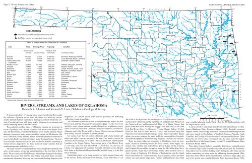
Page 12, Rivers, Streams, and Lakes<br />
EDUCATIONAL PUBLICATION 9: 2008<br />
EXPLANATION<br />
Scenic River; number corresponds to name in text<br />
Salt Plain; number corresponds to name in text<br />
Table 4. Major lakes and reservoirs in <strong>Oklahoma</strong><br />
Lake Area Drainage Area a Capacity Location<br />
Normal Pool<br />
Normal Pool<br />
(acres) (square miles) (acre-feet) County/Counties<br />
Eufaula 105,500 47,522 2,314,600 McIntosh; Pittsburg; Haskell<br />
Texoma 88,000 39,719 2,643,300 Love; Marshall; Bryan; Johnston<br />
Grand Lake O’ the 46,500 10,298 1,672,000 Delaware; Ottawa; Mayes<br />
Cherokees<br />
Robert S. Kerr 43,800 147,756 525,700 Haskell; Sequoyah; Le Flore<br />
Oologah 29,460 4,339 553,400 Rogers; Nowata<br />
Keystone 23,610 74,506 557,600 Osage; Pawnee; Creek; Tulsa<br />
Fort Gibson 19,900 12,492 365,200 Wagoner; Cherokee; Mayes<br />
Kaw 17,040 46,530 428,600 Kay; Osage<br />
Broken Bow 14,200 754 918,070 McCurtain<br />
Sardis 13,610 275 274,330 Pushmataha; Latimer<br />
Hugo 13,250 1,709 157,600 Choctaw<br />
Tenkiller 12,900 1,610 654,100 Cherokee; Sequoyah<br />
Webbers Falls 11,600 97,033 170,100 Muskogee<br />
Hudson 10,900 11,533 220,300 Mayes<br />
Skiatook 10,190 354 322,700 Osage<br />
Waurika 10,100 562 203,100 Jefferson; Stephens; Cotton<br />
Foss 8,880 1,496 256,220 Custer<br />
Great Salt Plains 8,690 3,200 31,420 Alfalfa<br />
Canton 7,910 12,483 111,310 Blaine; Dewey<br />
Wister 7,333 993 62,360 Le Flore<br />
a<br />
Data from the <strong>Oklahoma</strong> Water Resources Board (1990).<br />
RIVERS, STREAMS, AND LAKES OF OKLAHOMA<br />
Kenneth S. Johnson and Kenneth V. Luza, <strong>Oklahoma</strong> <strong>Geological</strong> <strong>Survey</strong><br />
A stream is any body of running water, large or small, that flows under<br />
the influence of gravity toward lower elevations in a relatively narrow,<br />
clearly defined channel. Each major drainage system in <strong>Oklahoma</strong> consists<br />
of a principal river, with many smaller tributary rivers, streams, and<br />
creeks funneling water to the main course.<br />
The condition and flow rates of <strong>Oklahoma</strong> streams are temporary in<br />
terms of geologic time. Stream positions shift as they cut deeper channels<br />
into their banks, while their tributaries erode nearby uplands. Major<br />
drainage systems of today were established during the Pleistocene (the<br />
last 1.6 million years). Streams flowed across <strong>Oklahoma</strong> for millions of<br />
years before finally carving out today’s major drainage basins. The positions<br />
of earlier streams are marked now by alluvial deposits remaining as<br />
stream terraces, high above the flood plains of today’s streams that are<br />
eroding deeper into underlying rocks.<br />
All major streams in <strong>Oklahoma</strong> have broad, sand-filled channels with<br />
active water courses occupying a small portion of the river bed or flood<br />
plain. These broad, sand-filled channels reflect large changes in discharge<br />
(floods) that occur from time to time. Many man-made dams on major<br />
streams and tributaries, however, have decreased flooding frequency and<br />
magnitude. As a result, active water courses gradually are stabilizing<br />
within their broad stream beds.<br />
All <strong>Oklahoma</strong> streams are within two major drainage basins: the Red<br />
River basin, and the Arkansas River basin (see page 14). The two rivers<br />
and their many tributaries flow into <strong>Oklahoma</strong> from neighboring states,<br />
while all surface water from <strong>Oklahoma</strong> flows into Arkansas, via the Red,<br />
Arkansas, and Little Rivers, and Lee Creek. Major rivers and tributaries<br />
flow mainly east and southeast across <strong>Oklahoma</strong>.<br />
Six scenic rivers flow in eastern <strong>Oklahoma</strong> and several natural salt<br />
plains and saline rivers are present in the west. Five scenic rivers in the<br />
Arkansas River drainage are in Adair, Cherokee, Delaware, and Sequoyah<br />
Counties in the Ozark Plateau. They include parts of the Illinois River<br />
(1, see map), and Flint (2), Baron Fork (3), Little Lee (4), and Lee (5)<br />
Creeks. The upper part of Mountain Fork (6), which flows into Broken<br />
Bow Lake in the Ouachita Mountains in McCurtain County, is in the Red<br />
River drainage.<br />
Natural salt plains occur along some rivers where natural brines seep<br />
to the surface. In the Arkansas River drainage, Great Salt Plains (1) on<br />
Salt Fork is the largest salt flat <strong>cover</strong>ing about 25 square miles. Others in<br />
northwestern <strong>Oklahoma</strong> are Big Salt Plain (2) and Little Salt Plain (3) on<br />
the Cimarron River, and Ferguson Salt Plain (4) in Blaine County. Salt<br />
plains in the Red River drainage are Boggy Creek Salt Plain (5) on North<br />
Fork Red River; Kiser (6), Robinson (7), and Chaney (Salton) (8) Salt<br />
Plains on Elm Fork in north Harmon County; and Jackson County Salt<br />
Plain (9). Downstream in both drainage basins, fresh-water inflow dilutes<br />
saline river waters, making the water usable for municipalities, livestock,<br />
and industrial purposes before reaching Keystone Lake or Lake Texoma.<br />
There are many lakes and reservoirs in <strong>Oklahoma</strong>; most are manmade,<br />
created by damming streams for flood control, water supply, recreation,<br />
fish, wildlife, and hydroelectric power. Lakes on the Arkansas<br />
and Verdigris Rivers aid in navigation along the McClellan-Kerr Navigation<br />
System. Major lakes are formed behind dams built by the U.S.<br />
Army Corps of Engineers, U.S. Bureau of Reclamation, and the Grand<br />
River Dam Authority. Various state and federal agencies, cities, and other<br />
entities own and operate large lakes. Farmers and landowners have built<br />
many smaller lakes and ponds. Table 4 lists the 20 <strong>Oklahoma</strong> lakes with<br />
the largest surface areas.<br />
A series of oxbow and playa lakes are the only natural lakes in <strong>Oklahoma</strong><br />
(<strong>Oklahoma</strong> Water Resources Board, 1990). Typically crescentshaped,<br />
oxbow lakes occupy abandoned channels of meandering streams<br />
and occur mainly in flood plains of the Red, Arkansas, Washita, North<br />
Canadian, and Verdigris Rivers in central and eastern <strong>Oklahoma</strong>. <strong>Oklahoma</strong><br />
has 62 oxbow lakes <strong>cover</strong>ing at least 10 acres each; the largest,<br />
near Red River in McCurtain County, <strong>cover</strong>s 272 acres (<strong>Oklahoma</strong> Water<br />
Resources Board, 1990).<br />
Playa lakes form in shallow, saucer-like depressions scattered across<br />
the semiarid High Plains in northwestern <strong>Oklahoma</strong> and the Panhandle.<br />
Playa lakes have no outflow, holding water during and after rainy seasons<br />
before evaporating, or losing water by infiltrating into the ground. <strong>Oklahoma</strong><br />
has about 600 of these intermittent or ephemeral playa lakes, but<br />
only a few persist year-round (<strong>Oklahoma</strong> Water Resources Board, 1990).