Inside pages without cover - Oklahoma Geological Survey
Inside pages without cover - Oklahoma Geological Survey
Inside pages without cover - Oklahoma Geological Survey

You also want an ePaper? Increase the reach of your titles
YUMPU automatically turns print PDFs into web optimized ePapers that Google loves.
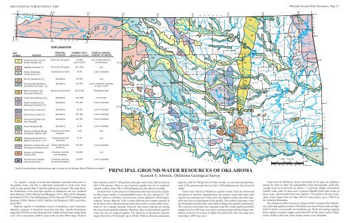
EDUCATIONAL PUBLICATION 9: 2008 Principal Ground-Water Resources, Page 13<br />
EXPLANATION<br />
MAP<br />
SYMBOL<br />
AQUIFER<br />
PRINCIPAL<br />
LITHOLOGY<br />
COMMON YIELD<br />
(gallons per minute)<br />
GENERAL MINERAL<br />
CONTENT OF WATER<br />
Quaternary alluvium and<br />
terrace deposits (Q) 1<br />
Sand, silt, and gravel<br />
10–500<br />
(up to 2,000)<br />
Low to high (alluvium);<br />
low (terraces)<br />
Ogallala Formation (T)<br />
Sand, silt, and gravel<br />
25–1,500<br />
Low<br />
Antlers Sandstone<br />
(Trinity Group) (K 1<br />
)<br />
Sandstone and sand<br />
10–50<br />
Low to moderate<br />
Elk City Sandstone (P 4<br />
)<br />
Sandstone<br />
25–300<br />
Low<br />
Rush Springs Sandstone<br />
and Marlow Formation (P 3<br />
)<br />
Sandstone<br />
25–300<br />
Low to moderate; moderate<br />
to high in north<br />
Blaine Formation and<br />
Dog Creek Shale (P 2<br />
)<br />
Gypsum and dolomite<br />
300–2,500<br />
Moderate to high<br />
Cedar Hills Sandstone (P 2<br />
)<br />
Sandstone<br />
150–300<br />
Low to high<br />
Garber Sandstone and<br />
Wellington Formation (P 1<br />
)<br />
Sandstone<br />
25–400<br />
Low to moderate<br />
Oscar Group, area a (P 1<br />
)<br />
Sandstone<br />
25–50<br />
Low to moderate<br />
Oscar Group, area b (P 1<br />
)<br />
Sandstone<br />
50–180<br />
Low to moderate<br />
Vamoosa Formation and<br />
Ada Group (P 3<br />
)<br />
Sandstone<br />
25–150<br />
Low to moderate<br />
Noxie Sandstone (P 3<br />
)<br />
Sandstone<br />
10–50<br />
Low to moderate<br />
Keokuk and Reeds Spring<br />
Formations (“Boone”) (M)<br />
Limestone and cherty<br />
limestone<br />
5–50<br />
Low<br />
Arkansas Novaculite and<br />
Bigfork Chert (M, D, S, O)<br />
Fractured chert and<br />
novaculite<br />
10–50<br />
Low<br />
Roubidoux, Gasconade, and<br />
Eminence Formations (O, )<br />
Cherty dolomite and<br />
sandstone<br />
50–250<br />
Low to moderate<br />
Simpson and Arbuckle<br />
Groups (O, )<br />
Limestone, dolomite,<br />
and sandstone<br />
25–600<br />
Low<br />
Arbuckle and Timbered<br />
Hills Groups (O, )<br />
Limestone, dolomite,<br />
and some sandstone<br />
25–600<br />
Low to moderate<br />
1<br />
Symbols in parentheses indicate geologic age, as shown on the Geologic Map of <strong>Oklahoma</strong> on page 6.<br />
PRINCIPAL GROUND-WATER RESOURCES OF OKLAHOMA<br />
Kenneth S. Johnson, <strong>Oklahoma</strong> <strong>Geological</strong> <strong>Survey</strong><br />
An “aquifer” consists of rocks and sediments saturated with good- to<br />
fair-quality water, and that is sufficiently permeable to yield water from<br />
wells at rates greater than 25 gal/min (gallons per minute). This map shows<br />
the distribution of the principal aquifers in <strong>Oklahoma</strong> and was modified<br />
from Marcher (1969), Marcher and Bingham (1971), Hart (1974), Bingham<br />
and Moore (1975), Carr and Bergman (1976), Havens (1977), Bingham and<br />
Bergman (1980), Morton (1981), Marcher and Bergman (1983), and Johnson<br />
(1983).<br />
Bedrock aquifers in <strong>Oklahoma</strong> consist of sandstone, sand, limestone,<br />
dolomite, gypsum, or fractured novaculite and chert. Aquifer thicknesses<br />
range from 100 ft to several thousand feet. Depth to fresh water ranges from<br />
a few feet to more than 1,000 ft; most wells are 100–400 ft deep. Wells in<br />
these aquifers yield 25–300 gal/min, although some wells yield as much as<br />
600–2,500 gal/min. Water in most bedrock aquifers has low to moderate<br />
mineral content, about 300–1,500 milligrams per liter dissolved solids.<br />
Ground water is also present in Quaternary alluvium and terrace deposits<br />
that consist mainly of unconsolidated sand, silt, clay, and gravel. “Alluvium”<br />
refers to sediments in present-day stream channels or flood plains,<br />
whereas “terrace deposits” refer to older alluvium that remains (usually at<br />
an elevation above the present-day flood plain) after a stream shifts its position<br />
or cuts a deeper channel. Alluvium and terrace deposits are among<br />
the most recent geologic deposits; therefore, they overlie bedrock aquifers<br />
where the two are mapped together. The thickness of Quaternary deposits<br />
ranges from 10 to 50 ft (locally up to 100 ft). Wells in alluvium and terrace<br />
deposits yield 10–500 gal/min of water (locally several thousand gal/min);<br />
most of this ground water has less than 1,000 milligrams per liter dissolved<br />
solids.<br />
Fresh water stored in <strong>Oklahoma</strong> aquifers results from the downward<br />
movement of meteoric (precipitation) and surface waters that enter each<br />
aquifer at its recharge area. Fresh water may displace saline water that originally<br />
may have occupied parts of the aquifer. The system is dynamic; water<br />
percolating downward to the water table recharges the aquifer continuously.<br />
The vertical or horizontal rate of ground-water flow in the aquifers probably<br />
ranges from 5 to 100 ft per year; under certain geologic and hydrologic conditions,<br />
such as in cavernous or highly fractured rocks, flow can range up to<br />
more than 1,000 ft per year.<br />
Large areas of <strong>Oklahoma</strong>, shown uncolored on the map, are underlain<br />
mostly by shale or other low-permeability rocks that typically yield only<br />
enough water for household use (about 1–5 gal/min). Highly mineralized<br />
(saline) water, unfit for most uses, is present beneath fresh-water zones in<br />
these rocks, and beneath fresh-water aquifers. The depth to the top of this<br />
saline water ranges from less than 100 ft in some places, up to 3,000 ft in<br />
the Arbuckle Mountains.<br />
The <strong>Oklahoma</strong> Water Resources Board (1990) estimated that <strong>Oklahoma</strong>’s<br />
principal aquifers contain 320 million acre-feet of fresh water, perhaps<br />
half of which is re<strong>cover</strong>able for beneficial use. Wells and springs tapping<br />
these aquifers currently supply more than 60% of the water used in <strong>Oklahoma</strong>,<br />
chiefly in the west where surface-water is less abundant.