The Aire Valley Towpath Route - Sustrans
The Aire Valley Towpath Route - Sustrans
The Aire Valley Towpath Route - Sustrans

Create successful ePaper yourself
Turn your PDF publications into a flip-book with our unique Google optimized e-Paper software.
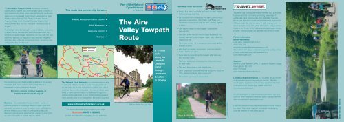
<strong>The</strong> <strong>Aire</strong> <strong>Valley</strong> <strong>Towpath</strong> <strong>Route</strong> provides a wonderful<br />
opportunity to explore part of the longest canal in Britain. It<br />
encompasses both vibrant urban areas and beautiful countryside,<br />
taking you on a peaceful route through Leeds and out past<br />
Kirkstall Abbey, Bramley Fall, Rodley, Calverley Woods,<br />
Apperley Bridge, Buck Wood at Thackley, Shipley, Hirst<br />
Wood, Dowley Gap and the Three and Five Rise Locks at<br />
Bingley.<br />
<strong>The</strong> highlight attraction along the route is Saltaire, declared a<br />
UNESCO World Heritage Site due to its preservation as a<br />
Victorian Industrial Village. Named for Sir Titus Salt, the area<br />
has many features, so be sure to stop and visit the gallery<br />
and many fine boutiques and antique shops, as well as marvelling<br />
at the fine architecture.<br />
Near Kirkstall Marina<br />
<strong>The</strong> route forms part of National <strong>Route</strong>s 66 and 69, serving<br />
commuter and leisure walkers and cyclists alike. It is<br />
maintained in part by Volunteer Rangers.<br />
For more details visit our website at<br />
www.airevalleytowpath.org.uk<br />
<strong>Sustrans</strong> - the sustainable transport charity - works on<br />
practical projects to encourage people to walk, cycle and<br />
use public transport in order to reduce motor traffic and its<br />
adverse effects. 5,000 miles of our flagship project, the<br />
National Cycle Network, were officially opened in June 2000,<br />
we will increase this to 10,000 miles by 2005.<br />
Andy Syme<br />
6<br />
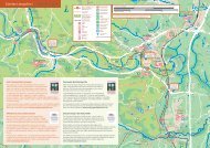
Burnley<br />
This route is a partnership between<br />
•<br />
•<br />
•<br />
Bradford Metropolitan District Council •<br />
68<br />
Skipton<br />
Keighley<br />
Halifax<br />
BINGLEY<br />
69<br />
66<br />
British Waterways<br />
Leeds City Council<br />
open routes<br />
proposed<br />
66<br />
Bradford<br />
<strong>Sustrans</strong><br />
map area<br />
Dewsbury<br />
63<br />
LEEDS<br />
Harrogate<br />
66<br />
Wakefield<br />
<strong>The</strong> National Cycle Network is a comprehensive network<br />
of safe and attractive routes to cycle throughout the UK.<br />
10,000 miles are due for completion by 2005, one third of<br />
which will be on traffic-free paths - the rest will follow quiet<br />
lanes or traffic-calmed roads. It is delivered through the<br />
policies and programmes of over 450 local authorities and<br />
other partners, and is co-ordinated by the charity <strong>Sustrans</strong>.<br />
www.nationalcyclenetwork.org.uk<br />
For more information on routes in your area:<br />
<strong>Sustrans</strong> 0845 113 0065<br />
or visit the interactive mapping on our web site.<br />
•<br />
•<br />
•<br />
Wetherby<br />
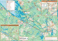
Part of the National<br />
Cycle Network<br />
in Yorkshire<br />
66 69<br />
<strong>The</strong> <strong>Aire</strong><br />
<strong>Valley</strong> <strong>Towpath</strong><br />
<strong>Route</strong><br />
British Waterways<br />
Saltaire World Heritage Site<br />
A 17 mile<br />
route<br />
along the<br />
Leeds &<br />
Liverpool<br />
Canal<br />
through<br />
Leeds and<br />
Bradford<br />
to Bingley<br />
Waterways Code for Cyclists<br />
• Always fit a bell to your bike and use it to warn people<br />
that you are approaching.<br />
• Be courteous and considerate and warn others of your<br />
approach in good time. Say “hello” and “thank you”.<br />
Remember some people may be deaf, partially sighted<br />
or blind.<br />
• Give way to others on the towpath - pedestrians<br />
have priority.<br />
• Dismount under low and blind bridges and where the<br />
towpath narrows under bridges. Again warn others by<br />
ringing your bell.<br />
• Never race or skid - it is dangerous and breaks up the<br />
towpath surface.<br />
•Watch out for anglers’ equipment - give them time to<br />
move it before you pass.<br />
• If you have to cycle along the towpath after dark use<br />
front and rear lights.<br />
•Take care at all road crossing points. Stop and check<br />
for road traffic.<br />
•Take your litter home or use rubbish bins.<br />
• Don’t forget your puncture repair kit and pump, food and<br />
drink, waterproof jacket and a cycle lock.<br />
• Remember - give way to pedestrians.<br />
Near Rodley Nature Reserve<br />
Leeds City Council<br />
TravelWise is a working partnership between local authorities,<br />
business and the community promoting awareness of<br />
sustainable travel opportunities. <strong>The</strong> <strong>Aire</strong> <strong>Valley</strong> <strong>Towpath</strong><br />
<strong>Route</strong> runs adjacent to both the <strong>Aire</strong>dale railway line and the<br />
760 bus route. So, why not cycle or walk one way and<br />
return by train or bus. For further information, please contact<br />
Metro on 0113 245 7676. Most trains have provision to carry<br />
bicycles. Folding bicycles can generally be carried on buses.<br />
Further Information<br />
British Waterways<br />
Lock Lane, Castleford WF10 2LH<br />
01977 554 351<br />
enquiries.yorkshire@britishwaterways.co.uk<br />
Other information about waterside areas and cycling on the<br />
national waterway network is available from<br />
www.waterscape.com<br />
<strong>Sustrans</strong><br />
National Cycle Network Centre, 2 Cathedral Square, College<br />
Green, Bristol BS1 5DD<br />
0845 113 0065<br />
www.nationalcyclenetwork.org.uk<br />
Leeds Cycling Action Group is a voluntary group involved<br />
in all aspects of promoting cycling in the city. Monthly<br />
meetings and regular newsletters keep members informed.<br />
2 Norwood Croft, Stanningley, Leeds LS28 6NH<br />
www.leedscyclists.org.uk<br />
An online resource to help you get out and about with your<br />
cycle on West Yorkshire’s extensive public transport system.<br />
www.cycletransport-westyorks.co.uk<br />
Leeds and Bradford Councils have produced cycle maps of<br />
the cities. <strong>The</strong> Leeds map can be viewed online via the<br />
council’s website at www.leeds.gov.uk<br />
Near Newlay Marina
<strong>Aire</strong> <strong>Valley</strong> <strong>Towpath</strong> <strong>Route</strong><br />
Leeds to Bingley<br />
British Waterways<br />
Apperley Bridge<br />
Five Rise Locks, Bingley<br />
<strong>Route</strong> partners<br />
Andy Syme<br />
© Crown copyright.<br />
All rights reserved<br />
<strong>Sustrans</strong>.<br />
Licence No:<br />
GD03181G0001<br />
October 2004<br />
Britannia cycle and footbridge, Bingley<br />
Canalside family ride