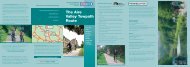
Jubilee River Cycle Route leaflet - Sustrans
Jubilee River Cycle Route leaflet - Sustrans
Jubilee River Cycle Route leaflet - Sustrans

Create successful ePaper yourself
Turn your PDF publications into a flip-book with our unique Google optimized e-Paper software.
Maidenhead<br />
Maidenhead<br />
Station<br />
To Reading<br />
BRAY ROAD<br />
B3028<br />
<strong>River</strong> Thames<br />
A4<br />
1<br />
2<br />
MARSH LA<br />
Taplow Station<br />
BATH ROAD<br />
8<br />
LAKE<br />
END RD<br />
Burnham Station<br />
Cippenham<br />
MERCIAN WAY<br />
A4 BATH ROAD<br />
CIPPENHAM LANE<br />
A355<br />
Slough Station<br />
Upton<br />
Lea<br />
A412<br />
To Uxbridge<br />
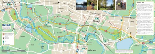
Points to note<br />
1 There is no easy cycle route between<br />
Maidenhead Bridge and the start of the <strong>Jubilee</strong><br />
<strong>River</strong> path at the Berry Hill traffic lights. If you are<br />
not confident cycling along the A4, push Iver your<br />
bike along the footway.<br />
2 Amerden Lane has a very poor surface with<br />
many potholes, but is great fun on a mountain<br />
bike!<br />
3 The path around Bray Lake has special<br />
barriers, which some may find difficult to<br />
negotiate.<br />
Iver Station<br />
A308<br />
Bray<br />
Dorney<br />
Wetlands<br />
5<br />
<strong>Jubilee</strong> <strong>River</strong><br />
M4 MOTORWAY<br />
Slough<br />
Langley Station<br />
Langley<br />
4 Sections of the route through Dorney Lake<br />
Park are grass only. They are usually quite<br />
rideable, but can be slippery when wet.<br />
Richings<br />
Park<br />
5 Some parts of the new bridleway between<br />
Mercian Way and Manor Farm Bridge are<br />
awaiting surface improvements. Take care in the<br />
meantime.<br />
A4 LONDON RD<br />
When you are on the<br />
National <strong>Cycle</strong> Network<br />
you will see these signs.<br />
A330<br />
National <strong>Cycle</strong> Network traffic-free<br />
National <strong>Cycle</strong> Network on-road<br />
Link and other route, mostly<br />
traffic free<br />
Railway (station)<br />
M4 MOTORWAY<br />
Holyport<br />
3<br />
A308 WINDSOR ROAD<br />
<strong>River</strong> Thames<br />
Dorney Court<br />
(Historic Houses<br />
Association)<br />
Dorney<br />
4<br />
Dorney Lake Park<br />
BOVENEY RD<br />
B3026 COMMON RD<br />
Eton Wick<br />
Linear Park<br />
A332<br />
Eton<br />
Eton<br />
College<br />
B3026<br />
Linear Park<br />
Due to open<br />
in 2008<br />
Ditton Park<br />
6<br />
B470<br />
7<br />
6 The routes through Ditton Park are available<br />
during daylight hours only. At other times use<br />
the alternative route via the A4 London Road<br />
between Upton Court Park and Brand’s Hill.<br />
7 Take care when using the spiral ramps and<br />
bridge/underpass to cross the motorway junction<br />
at Brand’s Hill.<br />
8 The path under the M4 may be closed at times<br />
of high flow on the <strong>Jubilee</strong> <strong>River</strong>.<br />
Take care point<br />
A4<br />
Tourist attraction<br />
B376 DATCHET RD<br />
Pub<br />
Cafe<br />
Information centre<br />
B3024<br />
0 Miles<br />
0.5 1 1.5<br />
0 Kilometres 0.5 1 1.5 2 2.5<br />
Fifield<br />
Oakley<br />
Green<br />
A308 MAIDENHEAD RD<br />
B3204<br />
To Windsor<br />
Great Park<br />
Windsor &<br />
Eton Central Station<br />
Windsor & Eton<br />
<strong>River</strong>side Station<br />
Windsor Castle<br />
Windsor<br />
<strong>River</strong> Thames<br />
Datchet Station<br />
Datchet<br />
Based on the Ordnance Survey map with the permission of the<br />
Controller of Her Majesty’s Stationery Office. Crown Copyright<br />
2008. Slough Borough Council. Licence No. 100019446<br />
Colnbrook<br />
Poyle<br />
To Heathrow
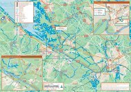
The main routes on this map are based on the <strong>Jubilee</strong><br />
<strong>River</strong> <strong>Cycle</strong>way, its eastward extension into Slough<br />
Linear Park and the section of the Thames Valley<br />
<strong>Cycle</strong> <strong>Route</strong> that passes through the area. These<br />
routes are all part of the National <strong>Cycle</strong> Network,<br />
National <strong>Route</strong>s 61 and 4. This <strong>leaflet</strong> shows where<br />
these routes are and how they can be easily accessed<br />
via links from the built-up areas around Slough,<br />
Windsor, Maidenhead and the surrounding villages.<br />
Being mainly within the flood plain of the <strong>River</strong> Thames,<br />
the routes are flat and make for easy cycling and<br />
walking. Most of the paths are well surfaced and are<br />
also suitable and accessible for pushchairs and disabled<br />
users, particularly the <strong>Jubilee</strong> <strong>River</strong> path, Slough Linear<br />
Park and the Thames Valley <strong>Cycle</strong> <strong>Route</strong>. The surfaces<br />
of small sections of the main paths and some parts of<br />
the link routes are in need of some improvement and<br />
wherever possible this has been noted in this <strong>leaflet</strong>.<br />
Where these have been identified, they should be<br />
regarded as less suitable for disabled users, novice<br />
cyclists and road bicycles with narrow tyres.<br />
The traffic-free routes shown are a combination of<br />
public rights of way, shared-use paths alongside some<br />
main roads and other paths over which rights to cycle<br />
have been permitted by the landowner. The <strong>leaflet</strong> does<br />
not attempt to distinguish between these, although<br />
permitted paths are usually identified by signs erected<br />
at entry points. Also indicated on the map are some onroad<br />
sections where these form part of National <strong>Cycle</strong><br />
Network <strong>Route</strong>s or where they provide essential links<br />
between traffic-free paths.<br />
Despite its proximity to the busy M4 and A4 transport<br />
corridor, these are in the main surprisingly quiet and<br />
peaceful routes surrounded mainly by farmland,<br />
woodland and open pasture.<br />
This map has been produced by <strong>Sustrans</strong> in partnership<br />
with Slough Borough Council and the Royal Borough of<br />
Windsor and Maidenhead<br />
Over the past decade a network of new traffic-free cycle routes<br />
have been constructed and made available within the mainly rural<br />
area between the towns of Slough, Maidenhead and Windsor.<br />
These routes, which can be easily accessed from many<br />
locations, aim to connect people and local communities with<br />
places of work, leisure and other centres. As such they provide<br />
ideal opportunities for family leisure cycling and to facilitate cycle<br />
journeys to work or school.<br />
The routes are a partnership between Slough Borough Council,<br />
the Environment Agency, the Royal Borough of Windsor and<br />
Maidenhead, Buckinghamshire County Council, the Millennium<br />
Commission and <strong>Sustrans</strong>, together with major landowners<br />
including Eton College, Dorney Lake Trust, CA, Summerleaze Ltd<br />
and Grundon Waste Management Ltd.<br />
<strong>Sustrans</strong> and the National <strong>Cycle</strong> Network<br />
<strong>Sustrans</strong> is the UK’s leading sustainable transport charity,<br />
working on practical projects so people choose to travel in<br />
ways that benefit their health and the environment. The charity<br />
is behind many groundbreaking projects including the National<br />
<strong>Cycle</strong> Network, over twelve thousand miles of traffic-free, quiet<br />
lanes and on-road walking and cycling routes around the UK.<br />
We are the charity making a difference today so everyone can<br />
live a better tomorrow.<br />
Support <strong>Sustrans</strong>. Join the movement.<br />
For more information on the National <strong>Cycle</strong> Network, to buy<br />
maps and guides or to become a <strong>Sustrans</strong> Supporter<br />
visit or call:<br />
www.sustrans.org.uk<br />
0845 113 00 65<br />
© <strong>Sustrans</strong> June 2008. Registered Charity No 326550 (England and Wales), SC039263 (Scotland)<br />
The <strong>Jubilee</strong> <strong>River</strong> &<br />
Slough Linear Park<br />
Traffic-free cycling opportunities between<br />
Slough, Maidenhead and Windsor<br />
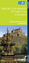
BERKSHIRE & BUCKINGHAMSHIRE CYCLE MAP<br />
Attractions along the routes<br />
The <strong>Jubilee</strong> <strong>River</strong> www.environment–agency.co.uk<br />
The seven-mile-long man-made flood channel was<br />
constructed by the Environment Agency and opened<br />
in 2002. Running between Maidenhead and Windsor,<br />
it provides a haven for fish, birds, animals and people.<br />
Highlights include the ‘Dorney Wetlands’, an area specially<br />
created to provide a superb breeding and feeding habitat<br />
for many bird species. A well surfaced 3-metre-wide path<br />
follows its entire length, with most of this being available<br />
to cyclists. National <strong>Route</strong> 61 starts at the A4 bridge at<br />
Taplow and follows the <strong>Jubilee</strong> <strong>River</strong> before branching<br />
off at The Myrke continue eastwards through the Slough<br />
Linear Park.<br />
Slough Linear Park<br />
As the name implies, this is a narrow green corridor,<br />
developed by Slough Borough Council and other partners,<br />
with a footpath/cyclepath provided along its length. It<br />
starts at the borough boundary at Manor Farm Bridge<br />
and extends along <strong>Jubilee</strong> <strong>River</strong>, then through Upton<br />
Court Park and Ditton Park to the edge of the Queen<br />
Mother Reservoir. The land to connect Upton Court Park<br />
and Ditton Park and thus complete the Linear Park has<br />
now been acquired by the Council and path construction<br />
should be completed during 2008. Much of the funding<br />
for new paths within the Linear Park has been provided<br />
by Grundon Waste Management Ltd via the Landfill Tax<br />
Credit Scheme.<br />
Ditton Park www.ca.com<br />
Ditton Manor and estate, formerly the home of Lord<br />
Montagu, was purchased by the Admiralty in 1917 for<br />
research purposes and subsequently acquired in 1997<br />
by Computer Associates Ltd. CA (as it is now known)<br />
constructed its European HQ at Ditton Park and as part of<br />
a planning agreement has opened up a footpath/cyclepath<br />
through the park. Thus, with the opening of the northsouth<br />
route in 2006, public access to this magnificent<br />
parkland became available for the first time. The east-west<br />
route will also be opened once the Linear Park link to<br />
Upton Court Park is constructed later in 2008.<br />
Dorney Lake Park www.dorneylake.com<br />
Splendid park and arboretum set around the 2,000-metre<br />
Eton College Rowing Lake, a venue for the 2012<br />
Olympics, and open to the public throughout the year.<br />
National <strong>Route</strong> 4 runs through the park from the Thames<br />
at Summerleaze Bridge through to Boveney.<br />
Windsor and Eton www.windsor.gov.uk<br />
The historic town centres of Windsor and Eton together<br />
with the adjacent riverside areas need little introduction<br />
and are certainly worth a visit. They are easy to access by<br />
bike from the various cycle routes shown. Elsewhere along<br />
the river, cycling is permitted on part of the Thames Path<br />
between Eton Wick and Windsor as shown on the route<br />
map overleaf.<br />
Additional cycling opportunities<br />
Thames Valley <strong>Cycle</strong> <strong>Route</strong> (TVCR)<br />
www.sustrans.org.uk<br />
Part of National <strong>Route</strong> 4 of the National <strong>Cycle</strong> Network which<br />
is a continuous route going all the way from the Thames<br />
Barrage in London to St Davids in Pembrokeshire! Running<br />
locally between Windsor and Maidenhead, it continues<br />
eastwards through Windsor Great Park to Runnymede,<br />
Staines and then on to London. Westwards from<br />
Maidenhead, it runs via Knowl Hill and Wargrave to Reading.<br />
From there the TVCR takes National <strong>Route</strong> 5 to Oxford, while<br />
National <strong>Route</strong> 4 follows the Kennet and Avon <strong>Cycle</strong> <strong>Route</strong><br />
all the way to Bristol and beyond. Locally there is an excellent<br />
traffic-free section between Cox Green and Knowl Hill. Just<br />
follow the National <strong>Route</strong> 4 signs from Maidenhead Station!<br />
A full route map of the TVCR is available from <strong>Sustrans</strong>.<br />
Windsor Great Park www.theroyallandscape.co.uk<br />
Easily accessed by following the National <strong>Route</strong> 4 signs<br />
from Windsor Leisure Centre, Windsor Great Park is an<br />
excellent area for both novice and experienced cyclists<br />
alike. Cyclists can use most of the very quiet tarmac<br />
roads, but please note that cycling is not permitted on the<br />
Long Walk or anywhere off road.<br />
Other cycle routes within Slough,<br />
Windsor and Maidenhead<br />
www.slough.gov.uk www.rbwm.gov.uk<br />
Both Slough Borough Council and the Royal Borough<br />
of Windsor and Maidenhead produce separate maps<br />
showing all recommended cycle routes within the towns.<br />
Copies are available from their respective offices, visitor<br />
information centres and some bike shops. Alternatively<br />
see their websites for details.<br />
Opportunities for new or inexperienced cyclists<br />
A small local group<br />
formed in association<br />
with Slough Borough<br />
Council and <strong>Sustrans</strong>,<br />
and known as Slough<br />
Freewheelers, will<br />
provide guided rides<br />
for new or inexperienced cyclists or those that would<br />
simply prefer to ride with a group. The rides are generally<br />
around six miles long and normally on traffic-free routes<br />
depicted on this <strong>leaflet</strong>. The rides take place once a<br />
month on a Saturday, either from Upton Court Park or<br />
Dorney Court. If you are interested, call Gerald Pleace at<br />
Slough Borough Council on 01753 875566 or e-mail him<br />
at gerald.pleace@slough.gov.uk for details.<br />
<strong>Cycle</strong> hire<br />
If you don’t have your own bicycle, but would like to<br />
cycle some of the routes shown on this <strong>leaflet</strong>, cycles<br />
can be hired from Windsor <strong>Cycle</strong> Hire at Alexandra<br />
Gardens in Windsor (01753 830220), Stows <strong>Cycle</strong>s in<br />
Dedworth Road, Windsor (01753 520529) or from DNA<br />
<strong>Cycle</strong>s, High St, Maidenhead (01628 780026).<br />
Remember<br />
All the traffic-free routes shown on this <strong>leaflet</strong> are<br />
also used by walkers, disabled users and in some<br />
cases horse riders. Cyclists must slow down when<br />
approaching other users and give them priority at<br />
all times.