RESPONSE TO PUBLIC COMMENTS - CBP.gov
RESPONSE TO PUBLIC COMMENTS - CBP.gov
RESPONSE TO PUBLIC COMMENTS - CBP.gov

Create successful ePaper yourself
Turn your PDF publications into a flip-book with our unique Google optimized e-Paper software.
1-29<br />
Response to Public Comments August 2008<br />
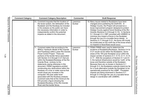
Comment Category Comment Category Description Commenter Draft Response<br />
10. Comment requests that the location of<br />
the levee system, the delineation of the<br />
floodplain and the floodway be included<br />
in the analysis so the public can have<br />
the necessary information in order to<br />
independently confirm the potential<br />
impacts as stated in the document<br />
11. Comment states that according to the<br />
IBWCs ‘Hydraulic Model of Rio Grande<br />
and Floodways within Lower Rio Grande<br />
Flood Control Project.’ There are<br />
portions of the border fence associated<br />
with Section O-4 through O-21 that are<br />
within the floodplain/floodway of the Rio<br />
Grande River, contrary to the<br />
statements saying otherwise in this<br />
document. FEMA regulations prohibit<br />
constructing any obstructions within the<br />
floodway of a river or water source that<br />
would cause any increase in the<br />
computed 100-year water level<br />
associated with the floodway analysis.<br />
Comment asks that at the minimum the<br />
EIS provide a figure showing the<br />
floodplain/floodway of the Rio Grande<br />
River and the border fence.<br />
Lawrence<br />
Dunbar<br />
Lawrence<br />
Dunbar<br />
10. Many issues related to floodplains have been<br />
changed since publishing the Draft EIS. In<br />
Hidalgo County, the Project will proceed as a<br />
levee improvement program designed to protect<br />
Hidalgo County against future flooding of the Rio<br />
Grande (Sections O-4 through O-10). In Sections<br />
O-1 through O-3, <strong>CBP</strong> consulted with USIBWC to<br />
minimize any impact of fence in the floodplain<br />
through the use of a movable fence design. In<br />
Sections O-11 through O-21, the fence will mostly<br />
be constructed on the north toe of the levee where<br />
no impacts to flood flows would occur.<br />
11. FEMA FIRMS were used to determine the<br />
locations of floodplains/floodways. Sections 0-4 to<br />
O-21 would not be within the floodplains. Some<br />
areas of the 100-year floodplain occur within the<br />
impact corridor of sections O-7, O-10, O-11, O-15,<br />
O-17. With the exceptions of Section O-1 and O-<br />
3, the tactical infrastructure would be ‘north’ of the<br />
levee and therefore outside of the floodplain.<br />
Because there are no levees in Sections O-1<br />
through O-3, the floodplains extends inland too far<br />
for a route alternative outside the floodplain to be<br />
operationally practical for the USBP. Floodplain<br />
impacts are being minimized in Sections O-1<br />
through O-3 through the use of a movable fence<br />
design in coordination with USIBWC.<br />
Rio Grande Valley Sector Tactical Infrastructure