Delta Fish and Amphibian Study 2000-2003_ DATA ...
Delta Fish and Amphibian Study 2000-2003_ DATA ...
Delta Fish and Amphibian Study 2000-2003_ DATA ...

You also want an ePaper? Increase the reach of your titles
YUMPU automatically turns print PDFs into web optimized ePapers that Google loves.
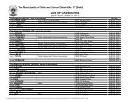
Watershed Site Coordinates Location<br />
Code NAD 83 : Zone 10<br />
BBA-2<br />
BBA-3<br />
BBA-4<br />
31 507036E. 5439340N East-West farm ditch at Highway 91, west side (~ 200 meters north of Lorne<br />
Ditch)<br />
32 506983E. 5438517N Ladner Trunk Road (Highway 10) north ditch, opposite the entrance to<br />
Oliver Park<br />
33 [not sampled] Ladner Trunk Road (Highway 10) south ditch, between 96th <strong>and</strong> 104th<br />
Streets<br />
34 [not sampled] Ladner Trunk Road (Highway 10) south ditch, between 104th <strong>and</strong> 112th<br />
Streets<br />
35 505378E. 5436278N Boundary Bay Dyke ditch, half way between the foot of 104th <strong>and</strong> 112th<br />
Streets<br />
51 507095E. 5439113N Lorne Ditch, 30 meters west of Highway 91<br />
52 501512E. 5437888N 88th Street east ditch, ~ 200 meters north of Burns Drive<br />
130 506600E. 5440059N Watershed Creek, in Watershed Park, in <strong>and</strong> around the step ponds<br />
131 507575E. 5438894N Lower Goldfish Creek at pool, east of Ladner Trunk Road (Highway 10) <strong>and</strong><br />
south of GVRD force main<br />
132 507534E. 5439199N Goldfish Creek, north of <strong>Delta</strong> Golf Course, along the east side of Ladner<br />
Trunk Road (Highway 10)<br />
133 507871E. 5439550N Goldfish Creek, in the canyon, north of Ladner Trunk Road (Highway 10)<br />
134 507578E. 5438523N North drainage watercourse (ditch) along the north side of the <strong>Delta</strong> Golf<br />
Course works yard, access road<br />
135 507534E. 5438444N Large Slough immediately west of the <strong>Delta</strong> Golf Course works yard<br />
(between BNSF rail line <strong>and</strong> Highway 91)<br />
142 507200E. 5439171N Briarwood Creek just north of the Ladner Trunk Road (Highway 10) onramp<br />
to Highway 91<br />
36 500958E. 5437464N Ladner Trunk Road (Highway 10) south ditch, ~ 500 - 600 meters west of<br />
88th Street<br />
53 501497E. 5437865N 88th Street west ditch, ~ 200 meters north of Burns Drive<br />
54 501476E. 5436032N 88th Street west ditch, at confluence of the east-west ditch at 4120 (opposite<br />
DeBoer farm buildings)<br />
55 502333E. 5435256N Beharrell pumpstation, ~ 5 meters upstream (north) of Boundary Bay Dyke<br />
56 501484E. 5437066N 88th Street west ditch, at 4626 (~ halfway between Highway 10 <strong>and</strong> the<br />
railway tracks)<br />
1 499878E. 5436664N Centre Slough at 80th Street, pool downstream (east) of 80th Street culvert<br />
2 500685E. 5436652N Centre Slough at confluence with east section of Boundary Bay Airport<br />
perimeter ditch<br />
37 498256E. 5436605N 72nd Street east ditch, 5 meters south of Churchill Street<br />
38 498257E. 5435904N Boundary Bay Airport ditch, immediately east of 72nd Street, north of<br />
airport control tower<br />
39 498224E. 5434344N 72nd Street ditch west side, ~ 100 meters north of Boundary Bay Dyke<br />
(fronting Daryl Goodwin's house)<br />
57 499857E. 5436957N 80th Street west ditch at entrance to <strong>Delta</strong> Pacific Greenhouses (4431 - 80th<br />
Street)<br />
Tuesday, August 19, <strong>2003</strong> Page 2 of 6