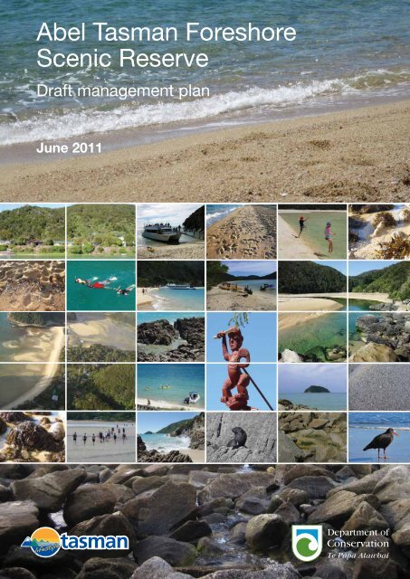
Abel Tasman Foreshore Scenic Reserve Draft Management Plan
Abel Tasman Foreshore Scenic Reserve Draft Management Plan
Abel Tasman Foreshore Scenic Reserve Draft Management Plan

You also want an ePaper? Increase the reach of your titles
YUMPU automatically turns print PDFs into web optimized ePapers that Google loves.
<strong>Abel</strong> <strong>Tasman</strong> <strong>Foreshore</strong><br />
<strong>Scenic</strong> <strong>Reserve</strong><br />
<strong>Draft</strong> management plan<br />
June 2011
<strong>Draft</strong> <strong>Abel</strong> <strong>Tasman</strong><br />
<strong>Foreshore</strong> <strong>Scenic</strong> <strong>Reserve</strong><br />
<strong>Management</strong> <strong>Plan</strong><br />
June 2011<br />
Published by:<br />
<strong>Tasman</strong> District Council and Department of Conservation<br />
Private Bag 4<br />
Nelson/Marlborough Conservancy<br />
Richmond Private Bag 5<br />
New Zealand<br />
Nelson, New Zealand
© Copyright 2011, <strong>Tasman</strong> District Council and New Zealand Department of Conservation<br />
Department of Conservation <strong>Management</strong> <strong>Plan</strong> Series no. 19<br />
ISSN 1170-9626 (print)<br />
ISSN 1179-4429 (online)<br />
ISBN 978-0-478-14844-2 (print)<br />
ISBN 978-0-478-14845-9 (online)<br />
Cover - all photos by Diana Parr except as follows:<br />
Awaroa baches – Jen Andrews; <strong>Abel</strong> <strong>Tasman</strong> Wilson’s Experience Vista – Martin Rodd; children leaping – Rob<br />
Greenaway; snorkelers – Elizabeth Bean; kayakers and Marahau Beach Camp water taxi - Grant Reburn;<br />
Torrent Bay – Eric Verstappen; Hui Te Rangiora (carved tekoteko on the gable of the meeting house,<br />
Turangapeke, at Te Awhina Marae, Motueka) – Rudy Tetteroo.
CONTENTS<br />
Preface 8<br />
The <strong>Abel</strong> <strong>Tasman</strong> <strong>Foreshore</strong> <strong>Scenic</strong> <strong>Reserve</strong> 10<br />
Vision 11<br />
Primary Objectives 11<br />
Outcomes at places 11<br />
How to use this plan 12<br />
Part A – Matters relating to <strong>Abel</strong> <strong>Tasman</strong> <strong>Foreshore</strong> <strong>Scenic</strong> <strong>Reserve</strong> as a whole 13<br />
1. Introduction 13<br />
1.1 <strong>Management</strong> planning and legislative context 13<br />
1.1.1 <strong>Abel</strong> <strong>Tasman</strong> <strong>Foreshore</strong> <strong>Scenic</strong> <strong>Reserve</strong>, adjacent lands and coastal 13<br />
waters<br />
1.1.2 Legislative context 13<br />
1.2 Administration 14<br />
1.2.1 Administration Committee 14<br />
1.2.2 <strong>Management</strong> <strong>Plan</strong> Approval Committee 14<br />
1.2.3 Nelson/Marlborough Conservation Board 14<br />
2. Treaty of Waitangi 15<br />
2.1 Giving effect to the Treaty 15<br />
2.2 Customary use 16<br />
2.2.1 Legislation 17<br />
2.2.2 Fishing (including shellfish) and seaweed harvesting 17<br />
2.2.3 Dead animals and plants 17<br />
3. Conservation of natural resources 19<br />
3.1 Terrestrial, freshwater and marine species, habitats and ecosystems 19<br />
3.1.1 Protection, restoration and preservation 22<br />
3.1.2 Fishing and the taking of seaweed and driftwood 23<br />
3.1.3 Survey, monitoring and research 24<br />
3.2 Biosecurity and management of threats to indigenous species, habitats and 24<br />
ecosystems<br />
3.2.1 Animal pests 25<br />
3.2.2 <strong>Plan</strong>t pests 25<br />
3.2.3 Biosecurity 26<br />
3.2.4 Other threats 26<br />
3.3 Fire management 27<br />
3.4 Geological features, landforms, and landscape 28<br />
3.4.1 Development and preservation 29<br />
3.5 Ecosystem services 31<br />
4. Historical and cultural heritage 32<br />
4.1 History 32<br />
4.1.1 Māori history 32<br />
4.1.2 European history 33<br />
4.1.3 Recent history 33<br />
Contents
4.2 <strong>Management</strong> of historical and cultural heritage 33<br />
4.2.1 Protection of historic places 33<br />
4.2.2 Protected objects 34<br />
4.2.3 Māori sites 35<br />
4.2.4 European sites, relics, and protected New Zealand objects 35<br />
4.2.5 Threats 35<br />
4.2.6 Interpretation 35<br />
4.2.7 Memorials 36<br />
5. Natural hazards 38<br />
6. People’s benefit and enjoyment 39<br />
6.1 <strong>Plan</strong>ning and management for people’s benefit and enjoyment 39<br />
6.1.1 Access and use 41<br />
6.1.2 Visitor experiences 42<br />
6.1.3 Recreational Zones 43<br />
6.1.4 Monitoring 58<br />
6.1.5 Noise 58<br />
6.1.6 Camping and overnight stays in vessels 58<br />
6.1.7 Educational and other large groups 58<br />
6.1.8 Human waste and litter 59<br />
6.1.9 Information including interpretation 59<br />
6.1.10 Advocacy 60<br />
6.2 Sports fishing and game bird hunting 61<br />
6.3 The use of vehicles and other forms of transport 62<br />
6.3.1 Land vehicles 62<br />
6.3.2 Vessels 63<br />
6.3.3 Aircraft 64<br />
6.4 Animals 64<br />
6.4.1 Horses 64<br />
6.4.2 Dogs 64<br />
6.4.3 Other domestic animals 65<br />
7. Accommodation and related facilities 66<br />
7.1 Accommodation 66<br />
7.2 Other facilities and structures 66<br />
7.2.1 Monitoring 67<br />
8. Activities requiring specific authorisation 68<br />
8.1 Concessions - general 68<br />
8.1.1 Processing concession applications 68<br />
8.1.2 Concession management 68<br />
8.1.3 Māori cultural values 69<br />
8.1.4 Concession monitoring 69<br />
8.2 Recreation concessions 70<br />
8.2.1 Recreation concession management 70<br />
8.2.2 Water-based commercially guided activity 73<br />
8.2.3 Water taxi activity 75<br />
8.2.4 Charter boat activity 77<br />
8.2.5 Support vessel activity 77<br />
Contents
8.2.6 Servicing floating accommodation activity 78<br />
8.2.7 Commercially guided walking activity 78<br />
8.2.8 Freedom water-based commercial activity 78<br />
8.2.9 Cruise ships 79<br />
8.2.10 Organised sporting events 80<br />
8.2.11 Sale or hire of goods and equipment 80<br />
8.2.12 Personal watercraft, hovercraft, amphibious vessels, other<br />
80<br />
unconventional vessels and parasailing<br />
8.2.13 Land vehicles 80<br />
8.2.14 Aircraft 80<br />
8.2.15 Noise 81<br />
8.2.16 Advertising 81<br />
8.2.17 Other concession activities 81<br />
8.2.18 Monitoring 82<br />
8.3 Non-recreation concessions 87<br />
8.3.1 Utilities 87<br />
8.3.2 Easements 87<br />
8.3.3 Aircraft 87<br />
8.3.4 Coastal fishing 87<br />
8.3.5 Removal of sand, shingle or other natural mineral material 88<br />
8.3.6 Commercial filming and photography 88<br />
8.3.7 Monitoring 88<br />
8.4 Other authorisations for non-commercial activities 89<br />
8.4.1 Processing applications for an authorisation 90<br />
8.4.2 Scientific research 90<br />
8.4.3 Monitoring 91<br />
9. Community relations 92<br />
9.1 Public participation in management of the reserve 92<br />
9.1.1 Local economies 92<br />
9.1.2 Consultation 93<br />
9.1.3 <strong>Abel</strong> <strong>Tasman</strong> <strong>Foreshore</strong> Advisory Forum 93<br />
9.1.4 Neighbouring lands 93<br />
9.1.5 Unformed legal roads, accreted land and other additions 94<br />
9.1.6 Aircraft 94<br />
9.1.7 Coastal waters 94<br />
9.1.8 Discharges from vessels 99<br />
9.1.9 Water and land-based commercial activity 100<br />
9.1.10 Moorings and other structures 100<br />
10. Implementation, monitoring, reporting and review 102<br />
10.1 <strong>Plan</strong> implementation, monitoring, reporting and review 102<br />
10.1.1 Implementation 102<br />
10.1.2 Monitoring 102<br />
10.1.3 Reporting 102<br />
10.1.4 Review 102<br />
10.2 Compliance and law enforcement 103<br />
10.3 Helicopter, vehicle and vessel use 103<br />
Contents
Part B – The Places within <strong>Abel</strong> <strong>Tasman</strong> <strong>Foreshore</strong> <strong>Scenic</strong> <strong>Reserve</strong> 105<br />
11. <strong>Foreshore</strong> Adjacent to Private Land 109<br />
11.1 Spatial definition of <strong>Foreshore</strong> Adjacent to Private Land 109<br />
11.2 Outcome for <strong>Foreshore</strong> Adjacent to Private Land 109<br />
11.3 Long-term objectives for <strong>Foreshore</strong> Adjacent to Private Land 110<br />
11.4 Conservation of natural resources 110<br />
11.4.1 Protection 110<br />
11.4.2 Pest management 110<br />
11.5 People’s benefit and enjoyment 111<br />
11.5.1 Visitor experiences 111<br />
11.5.2 Recreational Zones 112<br />
11.5.3 Land vehicles 113<br />
11.5.4 Vessels 113<br />
11.5.5 Dogs 116<br />
11.5.6 Educational and other large groups 116<br />
11.5.7 Advocacy 116<br />
11.6 Facilities and structures 117<br />
11.7 Activities requiring specific authorisation 118<br />
11.7.1 Recreation concessions 118<br />
11.7.2 Non-recreation concessions 120<br />
12. <strong>Foreshore</strong> Adjacent to National Park 123<br />
12.1 Spatial definition of <strong>Foreshore</strong> Adjacent to National Park 123<br />
12.2 Outcome for <strong>Foreshore</strong> Adjacent to National Park 123<br />
12.3 Long-term objective for <strong>Foreshore</strong> Adjacent to National Park 123<br />
12.4 Conservation of natural resources 124<br />
12.4.1 Protection, restoration and preservation 124<br />
12.4.2 Seals 124<br />
12.4.3 Island biosecurity and threat management 125<br />
12.5 People’s benefit and enjoyment 125<br />
12.5.1 Access 125<br />
12.5.2 Visitor experiences 125<br />
12.5.3 Recreational Zones 126<br />
12.5.4 Land vehicles 127<br />
12.5.5 Vessels 127<br />
12.5.6 Dogs 127<br />
12.6 Facilities and structures 128<br />
12.7 Activities requiring specific authorisation 129<br />
12.7.1 Recreation concessions 129<br />
Glossary 133<br />
Bibliography 145<br />
Appendices<br />
Appendix 1: <strong>Management</strong> planning 146<br />
Appendix 2: Legislation and statutory documents 148<br />
Appendix 3: <strong>Abel</strong> <strong>Tasman</strong> <strong>Foreshore</strong> <strong>Scenic</strong> <strong>Reserve</strong> creation, management and<br />
delegations<br />
154<br />
Contents
Appendix 4: Indigenous animal and plant species likely to be found within, or in<br />
the vicinity of, the reserve<br />
157<br />
Appendix 5: <strong>Abel</strong> <strong>Tasman</strong> <strong>Foreshore</strong> <strong>Scenic</strong> <strong>Reserve</strong> Bylaws 2008 161<br />
Appendix 6: General authorisation for <strong>Abel</strong> <strong>Tasman</strong> <strong>Foreshore</strong> <strong>Scenic</strong> <strong>Reserve</strong> 166<br />
Appendix 7: ‘Threatened’ and ‘at risk’ indigenous plants and animals of <strong>Abel</strong><br />
<strong>Tasman</strong> <strong>Foreshore</strong> <strong>Scenic</strong> <strong>Reserve</strong><br />
Appendix 8: Schedule 25.1F, <strong>Tasman</strong> Resource <strong>Management</strong> <strong>Plan</strong>: Areas with<br />
nationally or internationally important natural ecosystem values<br />
(within the coastal marine area)<br />
Appendix 9: Processes and principles for setting maximum activity levels for water<br />
taxi and charter boat activity<br />
167<br />
170<br />
171<br />
Appendix 10: Conservation General Policies (2005) referred to in this plan 173<br />
Maps<br />
Map 1: Location of <strong>Abel</strong> <strong>Tasman</strong> <strong>Foreshore</strong> <strong>Scenic</strong> <strong>Reserve</strong> 9<br />
Map 2: Recreational Zones 44<br />
Map 2A: Anchorage Coastal Access Points 46<br />
Map 2B: Torrent Bay/Rakauroa Coastal Access Points 47<br />
Map 2C: Bark Bay/Wairinga Coastal Access Point 48<br />
Map 2D: Onetahuti Coastal Access Point 49<br />
Map 2E: Awaroa Coastal Access Points 50<br />
Map 2F: Totaranui Coastal Access Point 51<br />
Map 2G: Awaroa Vehicle Access Corridor 55<br />
Map 3: Unformed legal roads and unalienated Crown land, Tinline Bay and 95<br />
Coquille Bay<br />
Map 4: Unformed legal roads and unalienated Crown land, Apple Tree Bay/ 96<br />
Whenuakura and Stilwell Bay<br />
Map 5: Unformed legal roads and unalienated Crown land, Torrent Bay/<br />
97<br />
Rakauroa, Boundary Bay, Frenchman Bay/Potikitawa and Sandfly Bay<br />
Map 6: <strong>Foreshore</strong> adjacent to <strong>Abel</strong> <strong>Tasman</strong> Memorial 98<br />
Map 7: Places 106<br />
Maps 7A, 7B & 7C: <strong>Foreshore</strong> Adjacent to Private Land detail 107<br />
Map 8: Awaroa Spit bird nesting/roosting area 114<br />
Map 9: Venture Creek swimming area 115<br />
Map 10: One nautical mile from the <strong>Abel</strong> <strong>Tasman</strong> <strong>Foreshore</strong> <strong>Scenic</strong> <strong>Reserve</strong> 135<br />
Tables<br />
Table 1: Maximum levels of water-based commercially guided activity 74<br />
Table 2: Maximum levels of water taxi activity 76<br />
Table 3: Maximum number of trips for charter boat activity 77<br />
Table 4: Maximum number of visits for cruise ship activity 79<br />
Table 5: Conditions for recreation concession activities on the <strong>Foreshore</strong> Adjacent 118<br />
to Private Land<br />
Table 6: Conditions for recreation concession activities on the <strong>Foreshore</strong> Adjacent 129<br />
to National Park<br />
Contents
Preface<br />
The <strong>Abel</strong> <strong>Tasman</strong> <strong>Foreshore</strong> <strong>Scenic</strong> <strong>Reserve</strong> was gazetted as a scenic reserve in<br />
January 2007. It is managed under delegated authority from the Minister of<br />
Conservation and the Director-General of Conservation by an Administration<br />
Committee, which consists of the Chief Executive Officer of <strong>Tasman</strong> District Council<br />
and the Conservator of the Nelson/Marlborough Conservancy of the Department of<br />
Conservation.<br />
This <strong>Draft</strong> <strong>Management</strong> <strong>Plan</strong> for the <strong>Abel</strong> <strong>Tasman</strong> <strong>Foreshore</strong> <strong>Scenic</strong> <strong>Reserve</strong> has been<br />
prepared by the Administration Committee in accordance with section 40B of the<br />
<strong>Reserve</strong>s Act 1977. This plan is a statutory document that implements the<br />
Nelson/Marlborough Conservation <strong>Management</strong> Strategy and provides for the<br />
management of the <strong>Abel</strong> <strong>Tasman</strong> <strong>Foreshore</strong> <strong>Scenic</strong> <strong>Reserve</strong> in accordance with the<br />
<strong>Reserve</strong>s Act 1977, the Conservation Act 1987 and Conservation General Policy 2005.<br />
This plan has been developed in consultation with the <strong>Abel</strong> <strong>Tasman</strong> <strong>Foreshore</strong><br />
Advisory Forum and representatives from tangata whenua, the Nelson/Marlborough<br />
Conservation Board, the local community and other interested groups and<br />
individuals.<br />
Once approved by the <strong>Management</strong> <strong>Plan</strong> Approval Committee, this plan will be<br />
effective until 2018 (to coincide with the review of the <strong>Abel</strong> <strong>Tasman</strong> National Park<br />
<strong>Management</strong> <strong>Plan</strong>, which was approved in October 2008), but a review (either in<br />
part or in full) may occur at any time due to increased knowledge or changes in<br />
circumstance.<br />
The Administration Committee<br />
Paul Wylie<br />
Chief Executive Officer<br />
<strong>Tasman</strong> District Council<br />
Neil Clifton<br />
Conservator<br />
Nelson/Marlborough Conservancy<br />
Department of Conservation<br />
16 May 2011<br />
By appointment and under delegated authority from the Minister of Conservation<br />
and the Director-General of Conservation<br />
Preface 8
MAP 1<br />
Location of <strong>Abel</strong> <strong>Tasman</strong> <strong>Foreshore</strong> <strong>Scenic</strong> <strong>Reserve</strong><br />
9
The <strong>Abel</strong> <strong>Tasman</strong> <strong>Foreshore</strong> <strong>Scenic</strong><br />
<strong>Reserve</strong><br />
The <strong>Abel</strong> <strong>Tasman</strong> coast is significant in terms of its scenic values. It has a diverse<br />
range of coastal landforms, including estuaries, sandy beaches, rocky headlands, rock<br />
stacks, islets and islands. Indigenous vegetation within <strong>Abel</strong> <strong>Tasman</strong> National Park<br />
forms the backdrop for most of the foreshore. The coastal scenery, golden-sand<br />
beaches, relatively sheltered coastal waters and bays attract thousands of visitors to<br />
the foreshore each year, via the tracks within the national park or from the coastal<br />
waters by a variety of vessels. The foreshore is also used and enjoyed by residents<br />
and visitors to the numerous private landholdings adjoining the reserve.<br />
After much discussion about the most appropriate way of managing the <strong>Abel</strong> <strong>Tasman</strong><br />
coast, the <strong>Abel</strong> <strong>Tasman</strong> <strong>Foreshore</strong> <strong>Scenic</strong> <strong>Reserve</strong> (‘the reserve) was gazetted as<br />
scenic reserve on 25 January 2007, under section 19(1)(a) of the <strong>Reserve</strong>s Act 1977<br />
(by the Minister for Land Information). At the time the reserve was created the<br />
<strong>Foreshore</strong> and Seabed Act 2004 was in force. This vested the ownership of the public<br />
foreshore and seabed in the Crown, and the Gazette notice (reserving the land under<br />
the Public Works Act 1981) specifically stated that the land would remain vested in<br />
the Crown. As a result of foreshore coming under the jurisdiction of the <strong>Reserve</strong>s Act<br />
1977, the Minister of Conservation became responsible for it.<br />
The reserve comprises 774 ha of foreshore, predominantly a narrow strip of land<br />
(other than in the estuaries) that lies between the Mean High Water Mark and Mean<br />
Low Water Springs, along the <strong>Abel</strong> <strong>Tasman</strong> coastline in the northwest of the South<br />
Island. It straddles <strong>Tasman</strong> Bay and Golden Bay, as shown on Map 1 (page 9). A large<br />
portion of the reserve adjoins land protected within <strong>Abel</strong> <strong>Tasman</strong> National Park,<br />
including the foreshore of all the islands in the park. Other parts of the reserve<br />
adjoin privately-owned land and reserves administered by <strong>Tasman</strong> District Council,<br />
including areas of road reserve. The central part of the reserve, between Awaroa Bay<br />
and Bark Bay/Wairinga, is overlain by the Tonga Island Marine <strong>Reserve</strong>.<br />
The reserve is managed by an Administration Committee (see section 1.2.1<br />
‘Administration Committee’ and Appendix 3), which arose from recommendations of<br />
the <strong>Abel</strong> <strong>Tasman</strong> <strong>Foreshore</strong> Advisory Forum (see section 9.1.3 ‘<strong>Abel</strong> <strong>Tasman</strong><br />
<strong>Foreshore</strong> Advisory Forum’). This makes the reserve unique. No other area of<br />
foreshore in the country is a scenic reserve under the administration of a committee<br />
made up of representatives from a territorial authority and the Department of<br />
Conservation.<br />
The primary purpose of designating the foreshore as scenic reserve was to maintain<br />
the quality of the visitor experience while protecting the natural features that make<br />
the <strong>Abel</strong> <strong>Tasman</strong> foreshore so special, including the scenic character of the coastline.<br />
The focus of this management plan is three-fold:<br />
(i)<br />
(ii)<br />
(iii)<br />
Continuing to allow the public and adjoining landholders to use and enjoy the<br />
area as they have for many years, with few constraints<br />
Maintaining and enhancing the experiences of visitors and adjoining<br />
landholders<br />
Reducing and mitigating the effects of visitor use, particularly through<br />
management of commercial activities.<br />
<strong>Abel</strong> <strong>Tasman</strong> <strong>Foreshore</strong> <strong>Scenic</strong> <strong>Reserve</strong> 10
Vision<br />
The <strong>Abel</strong> <strong>Tasman</strong> <strong>Foreshore</strong> <strong>Scenic</strong> <strong>Reserve</strong> is revered and safeguarded for all those<br />
who come after us.<br />
Primary Objectives<br />
Section 40B(1) of the <strong>Reserve</strong>s Act 1977 states that the purpose of a management<br />
plan includes the establishment of objectives for the management of the reserve<br />
according to the purpose for which the reserve is classified. Conservation General<br />
Policy 13(a)ii and vii (see Appendix 10) also states that this plan should identify<br />
planned outcomes, objectives and policies, consistent with the purpose for which the<br />
scenic reserve is held; and have regard to integrated management to achieve national<br />
conservation outcomes, and to coordinate planning between places covered by other<br />
strategies and plans.<br />
The Primary Objectives for the <strong>Abel</strong> <strong>Tasman</strong> <strong>Foreshore</strong> <strong>Scenic</strong> <strong>Reserve</strong> are:<br />
1. Effect given to achieving the Vision, and the outcomes for the <strong>Foreshore</strong><br />
Adjacent to Private Land and the <strong>Foreshore</strong> Adjacent to National Park places<br />
2. Preservation of the natural ecosystems and landscapes, the indigenous species<br />
of flora and fauna in their natural communities and habitats, and the natural<br />
character of the coastal environment, of the reserve<br />
3. Preservation of public access to and along the <strong>Abel</strong> <strong>Tasman</strong> coast, and its bays<br />
and inlets and offshore islands (except Tonga and Pinnacle Islands)<br />
4. Protection and preservation or enhancement, for the benefit, enjoyment and<br />
use of the public, of the intrinsic values of the reserve as an area possessing<br />
great beauty, natural features and landscapes<br />
5. <strong>Management</strong> and protection of the historical, archaeological, biological and<br />
other scientific features of the reserve, to the extent compatible with the other<br />
Primary Objectives<br />
6. Regard given to the collective multi-cultural values of the reserve<br />
7. Effect given to the principles of the Treaty of Waitangi, to the extent that they<br />
are consistent with the provisions of the <strong>Reserve</strong>s Act 1977<br />
8. Integrated management and use compatible with that of adjacent lands and<br />
waters (including <strong>Abel</strong> <strong>Tasman</strong> National Park, Tonga Island Marine <strong>Reserve</strong>,<br />
the adjacent coastal marine area and privately owned land), to the extent that<br />
it is consistent with the provisions of the <strong>Reserve</strong>s Act 1977<br />
Outcomes at places<br />
This plan applies the concept of ‘outcomes at places’ for the management of the<br />
reserve. The reserve is dealt with as a whole and as two places: <strong>Foreshore</strong> Adjacent to<br />
Private Land; and <strong>Foreshore</strong> Adjacent to National Park (see Maps 7, 7A, 7B and 7C,<br />
pages 106 and 107). The Outcomes are descriptions of what the two places will be like<br />
in 10 years time, which in large part reflect what they are like now (see sections 11.2<br />
Outcome for <strong>Foreshore</strong> Adjacent to Private Land and 12.2 Outcome for <strong>Foreshore</strong><br />
Adjacent to National Park).<br />
Vision / Primary Objectives / Outcomes at places 11
How to use this plan<br />
The plan is divided into two parts:<br />
1. Part A covers matters relating to the reserve as a whole -<br />
Chapter 1 addresses the management planning and legislative context for the<br />
reserve. This is followed, in Chapter 2, by an explanation of the significance of<br />
the Treaty of Waitangi and customary use in the reserve.<br />
Chapters 3 - 8 identify the values of the reserve, address issues associated with<br />
these values, and set out policies and methods for the reserve as a whole.<br />
Chapter 9 deals with issues that the Administration Committee does not have<br />
direct control over.<br />
Chapter 10 outlines the requirements in relation to the implementation,<br />
monitoring, reporting and review of this plan.<br />
2. Part B covers the detailed management of the two places in the reserve -<br />
Chapter 11 deals with the <strong>Foreshore</strong> Adjacent to Private Land and Chapter 12<br />
deals with the <strong>Foreshore</strong> Adjacent to National Park. Specific long term<br />
outcomes and objectives are identified for each place. Policies and methods are<br />
provided where there are specific issues that need addressing in each place,<br />
which are in addition to the provisions in Chapters 3 – 8.<br />
To help identify these provisions further, the pages of Chapter 11 (<strong>Foreshore</strong><br />
Adjacent to Private Land) are golden coloured and the pages of Chapter 12<br />
(<strong>Foreshore</strong> Adjacent to National Park) are green coloured.<br />
There is also a footnote at the bottom of each page to help identify what part of the<br />
plan you are in.<br />
Please note that, when viewing the contents of this plan, it is important to read and<br />
consider the plan provisions as a whole. Various objectives, policies and methods<br />
may influence the interpretation of other parts of the plan.<br />
Additional information boxes<br />
This draft plan includes explanatory text boxes (in grey) containing additional<br />
information relating to issues affecting management of the reserve. They are<br />
included to specifically seek feedback from the public and/or help the public better<br />
understand these issues and will not form part of the final plan.<br />
How to use this plan 12
Part A<br />
Matters relating to <strong>Abel</strong> <strong>Tasman</strong><br />
<strong>Foreshore</strong> <strong>Scenic</strong> <strong>Reserve</strong> as a<br />
whole<br />
1. Introduction<br />
1.1 <strong>Management</strong> planning and legislative context<br />
The provisions in this plan set out the expectations and guidance as to the overall<br />
management of the reserve by the Administration Committee, subject to availability<br />
of resources and community support. The process for preparing this plan is set out in<br />
Appendix 1.<br />
An explanation of the objectives, policies, methods and outcomes in this plan is<br />
provided in Appendix 1, as is an explanation on animal and plant classification.<br />
1.1.1 <strong>Abel</strong> <strong>Tasman</strong> <strong>Foreshore</strong> <strong>Scenic</strong> <strong>Reserve</strong>, adjacent lands and coastal waters<br />
Appendix 1 identifies the physical extent of the reserve, and its relationship to the<br />
adjacent lands and coastal waters.<br />
<strong>Reserve</strong> name<br />
The reserve was not officially named when it was created in 2007. However, the New<br />
Zealand Geographic Board/Ngā Pou Taunaha o Aotearoa subsequently gave notice<br />
that the official reserve name was ‘<strong>Abel</strong> <strong>Tasman</strong> <strong>Scenic</strong> <strong>Reserve</strong>’ (NZ Gazette 2009<br />
No. 73, pg 1700). The Administration Committee intends to submit a proposal to the<br />
Geographic Board to alter the English name to ‘<strong>Abel</strong> <strong>Tasman</strong> <strong>Foreshore</strong> <strong>Scenic</strong><br />
<strong>Reserve</strong>’ along with an appropriate te reo Mäori name.<br />
1.1.2 Legislative context<br />
This management plan gives effect to the <strong>Reserve</strong>s Act 1977, the Conservation Act<br />
1987, Conservation General Policy 2005, and the Nelson/Marlborough Conservation<br />
<strong>Management</strong> Strategy. The relevant legislation and other statutory documents that<br />
affect the management and administration of the reserve are provided in Appendix 2.<br />
Where any inconsistencies arise then the legislation shall prevail in the first instance,<br />
followed by the Conservation General Policy 2005 and the Conservation <strong>Management</strong><br />
Strategy.<br />
Bylaws and general authorisation<br />
Under section 106(3) of the <strong>Reserve</strong>s Act 1977, the Minister of Conservation may<br />
make bylaws for the reserve for a number of matters (such as controlling access and<br />
other activities). Such bylaws should be necessary for the proper administration and<br />
control of the reserve. There are bylaws for the reserve (see Appendix 5) that regulate<br />
some activities and allow others that would otherwise be an offence under the<br />
<strong>Reserve</strong>s Act 1977, such as walking a dog. This management plan proposes a number<br />
of amendments and additions to the bylaws. The Minister is responsible for<br />
1. Introduction 13
approving any amendment to the bylaws in accordance with section 108 of the<br />
<strong>Reserve</strong>s Act 1977.<br />
There is also a general authorisation (see Appendix 6), issued by the Administration<br />
Committee, that provides for other activities that would otherwise be an offence<br />
under the <strong>Reserve</strong>s Act 1977. The activities are: the use of traps, nets or fishing lines;<br />
the taking of fish and shellfish; the taking of seaweed; and the taking of driftwood.<br />
This management plan proposes some amendments to the general authorisation.<br />
1.2 Administration<br />
1.2.1 Administration Committee<br />
An Administration Committee is responsible for the administration and management<br />
of <strong>Abel</strong> <strong>Tasman</strong> <strong>Foreshore</strong> <strong>Scenic</strong> <strong>Reserve</strong> in accordance with this management plan.<br />
The Administration Committee comprises the Chief Executive Officer of <strong>Tasman</strong><br />
District Council and the Conservator of the Nelson/ Marlborough Conservancy of the<br />
Department of Conservation. This statutory body was appointed by the Minister of<br />
Conservation under Section 9 of the <strong>Reserve</strong>s Act 1977, with delegated powers and<br />
functions to administer and manage the reserve. The Director-General of<br />
Conservation has also delegated the powers of a Commissioner (under the <strong>Reserve</strong>s<br />
Act 1977) to the committee (see Appendix 3).<br />
The Administration Committee manages the reserve through <strong>Tasman</strong> District<br />
Council’s Main Office in Richmond and the Department of Conservation’s<br />
Nelson/Marlborough Conservancy Office in Nelson. Staff from these offices and the<br />
Area Offices of the Council and the, in Motueka and Takaka, are responsible for dayto-day<br />
operational management. Where appropriate, some of the Administration<br />
Committee’s powers and functions may be carried out by these staff.<br />
1.2.2 <strong>Management</strong> <strong>Plan</strong> Approval Committee<br />
The <strong>Management</strong> <strong>Plan</strong> Approval Committee is a subcommittee of the Nelson/<br />
Marlborough Conservation Board, formed in accordance with section 6N(2)(b) of the<br />
Conservation Act 1987. It comprises the Conservation Board chairperson, the Chief<br />
Executive Officer of <strong>Tasman</strong> District Council, the Conservator of the Nelson/<br />
Marlborough Conservancy of the Department of Conservation, one <strong>Tasman</strong> District<br />
Council nominee and two nominees from tangata whenua.<br />
The <strong>Management</strong> <strong>Plan</strong> Approval Committee is responsible for hearing submissions<br />
on this draft management plan, requesting revisions to the plan (if necessary), and<br />
approving the plan (see Appendix 3). Once the plan is approved, the <strong>Management</strong><br />
<strong>Plan</strong> Approval Committee’s role ceases, unless an amendment to the plan is proposed<br />
or until such time as the plan is reviewed (see section 10.1.4 ‘Review’).<br />
1.2.3 Nelson/Marlborough Conservation Board<br />
When this plan is approved the Nelson/Marlborough Conservation Board is<br />
responsible for advising the New Zealand Conservation Authority and the Director-<br />
General of Conservation on the implementation of this plan, which includes the<br />
issuing of concessions for the reserve, in accordance with section 6M(1)(c) of the<br />
Conservation Act 1987 and Conservation General Policy 13(e) and (f) (see Appendix<br />
10).<br />
1. Introduction 14
2. Treaty of Waitangi<br />
2.1 Giving effect to the Treaty<br />
Under section 4 of the Conservation Act 1987, the Administration Committee is<br />
required to interpret and administer the <strong>Reserve</strong>s Act 1977 to give effect to the<br />
principles of the Treaty of Waitangi. However, where there is clearly an inconsistency<br />
between the provisions of the <strong>Reserve</strong>s Act 1977 and the principles of the Treaty, the<br />
provisions of the <strong>Reserve</strong>s Act 1977 will prevail. This is reflected in the Primary<br />
Objectives for the reserve.<br />
This plan is subject to the developing jurisprudence of the courts on the<br />
interpretation of the principles of the Treaty of Waitangi and to the outcome of<br />
Treaty Settlement negotiations, and should be read together with the Conservation<br />
General Policy 2005, particularly Chapter 2; and policies 4.1(e), 4.4(h), 5(c) and<br />
12(d) (see Appendix 10).<br />
In this plan, the tangata whenua whose rohe (tribal boundaries) cover the <strong>Abel</strong><br />
<strong>Tasman</strong> <strong>Foreshore</strong> <strong>Scenic</strong> <strong>Reserve</strong> include Ngāti Tama Ki Te Tau Ihu (Ngāti Tama),<br />
Te Ātiawa Ki Te Tau Ihu (Te Ātiawa) and Ngāti Rārua.<br />
The Administration Committee needs to work co-operatively with Ngāti Tama, Te<br />
Ātiawa and Ngāti Rārua, and any other iwi who may be recognised by the Crown as<br />
being tangata whenua of the reserve, in a spirit of partnership (based on mutual good<br />
faith, co-operation and respect) to achieve the objectives of this plan. A partnership<br />
approach recognises the mana of tangata whenua and the desire to work together to<br />
maintain and support the reserve.<br />
Tangata whenua need to be given the opportunity to be actively involved in the<br />
preservation of the reserve’s values, including wāhi tapu and other taonga. The<br />
Administration Committee recognises and respects the desire of tangata whenua to<br />
exercise kaitiakitanga/customary practices of guardianship, in relation to places or<br />
resources that have spiritual or historical and cultural significance for them. Active<br />
involvement by tangata whenua can be supported and achieved in a number of<br />
different ways. Some of these ways are:<br />
(i)<br />
(ii)<br />
(iii)<br />
(iv)<br />
(v)<br />
(vi)<br />
Providing tangata whenua with information and technical advice<br />
Communicating with tangata whenua about proposed work associated with the<br />
reserve<br />
Consulting tangata whenua regarding the protection of wāhi tapu and other<br />
taonga (see section 4.2 ‘<strong>Management</strong> of historical and cultural heritage’)<br />
Establishing partnerships with tangata whenua on restoration and pest<br />
management projects, where appropriate (see section 3.2 ‘Biosecurity and<br />
management of threats to indigenous species, habitats and ecosystems’)<br />
Enabling customary use by tangata whenua on a case-by-case basis (see section<br />
2.2 ‘Customary use’)<br />
Consulting with tangata whenua on concession applications that affect their<br />
interests (see section 8.1.3 ‘Māori cultural values’)<br />
(vii) Developing public information and interpretation which refers to places or<br />
resources of spiritual or historical and cultural significance to Māori, in<br />
2. Treaty of Waitangi 15
consultation with tangata whenua (see section 4.2 ‘<strong>Management</strong> of historical<br />
and cultural heritage’).<br />
There are two iwi representatives (one nominated by Tiakina te Taiao Ltd 1 and one<br />
nominated by Manawhenua ki Mohua 2 ) on the <strong>Management</strong> <strong>Plan</strong> Approval<br />
Committee (see section 1.2.2 ‘<strong>Management</strong> <strong>Plan</strong> Approval Committee’); and three iwi<br />
representatives on the <strong>Abel</strong> <strong>Tasman</strong> <strong>Foreshore</strong> Advisory Forum (see section 9.1.3<br />
‘<strong>Abel</strong> <strong>Tasman</strong> <strong>Foreshore</strong> Advisory Forum’).<br />
Consultation from the early stages of any proposed undertaking that may affect the<br />
interests of tangata whenua and full consideration of their views is essential.<br />
At the time of notifying this draft plan there were claims registered with the Waitangi<br />
Tribunal that affect some areas of the reserve, including Adele Island/ Motuareronui,<br />
Fisherman Island/Motuarero-iti and some land at Anchorage. In the event that<br />
the settlement of any Treaty claim affects the management of the reserve, this should<br />
be addressed through the Treaty settlement legislation. The Administration<br />
Committee seeks to avoid any actions which would be a breach of the principles of<br />
the Treaty of Waitangi.<br />
2.1 Policy<br />
1. To give effect to the principles of the Treaty of Waitangi, to the extent that they<br />
are consistent with the provisions of the <strong>Reserve</strong>s Act 1977.<br />
2.1 Methods<br />
1. Encourage and support tangata whenua involvement and participation in the<br />
protection and preservation of the reserve, including the provision of<br />
information and cultural advice.<br />
2. Regularly communicate with tangata whenua about management work<br />
proposed for the reserve.<br />
3. Actively consult with tangata whenua throughout the term of this plan<br />
regarding its implementation.<br />
2.2 Customary use<br />
Māori have traditionally gathered plants and animals from the land and water for<br />
customary use (the gathering and use of natural resources by tangata whenua<br />
according to tikanga). There has been a revival of former traditions and the use of<br />
customary materials including, but not limited to: indigenous plants used in weaving<br />
and for rongoā/medicine; and indigenous birds and animals for their feathers and for<br />
food. Many of the traditional materials and indigenous species remaining today are<br />
found on lands administered by <strong>Tasman</strong> District Council and the Department of<br />
Conservation, and may be requested by tangata whenua. When tangata whenua wish<br />
to undertake customary use in the reserve they should contact the Department of<br />
Conservation’s Pou Kura Taiao/Iwi Manager in the first instance.<br />
1 Represents the iwi of Nelson and <strong>Tasman</strong> Bay – Ngāti Rārua, Te Ātiawa, Ngāti Tama and Ngāti<br />
Koata<br />
2 Represents the iwi of Golden Bay - Ngāti Rārua, Te Ātiawa and Ngāti Tama<br />
2. Treaty of Waitangi 16
2.2.1 Legislation<br />
The classification of <strong>Abel</strong> <strong>Tasman</strong> <strong>Foreshore</strong> <strong>Scenic</strong> <strong>Reserve</strong> as a scenic reserve under<br />
section 19(1)(a) of the <strong>Reserve</strong>s Act 1977 provides a high degree of protection to its<br />
indigenous plants and animals. The <strong>Reserve</strong>s Act 1977 states that:<br />
3(1)(b) ‘Ensuring, as far as possible, the survival of all indigenous species of flora<br />
and fauna, both rare and commonplace, in their natural communities and<br />
habitats…<br />
19(2)(a) ‘… the indigenous flora and fauna, ecological associations … shall as far as<br />
possible be preserved …’<br />
An authorisation (see section 8.4 ‘Other authorisations for non-commercial<br />
activities’) is required for customary use, except for fishing and seaweed harvesting<br />
(see section 2.2.2 ‘Fishing (including shellfish) and seaweed harvesting’).<br />
Conservation General Policies 2(g) and 4.1(e) (see Appendix 10) set out the criteria<br />
by which the customary use of traditional materials and indigenous species may be<br />
authorised.<br />
In addition, Conservation General Policy 4.4(h) (see Appendix 10) identifies that<br />
tangata whenua will be provided with access to the remains of dead marine protected<br />
species for customary use consistent with relevant legislation and agreed protocols.<br />
Given the reserve context, both the Administration Committee and tangata whenua,<br />
as kaitiaki/guardians, have a responsibility to ensure that indigenous plants and<br />
animals are preserved for future generations.<br />
2.2.2 Fishing (including shellfish) and seaweed harvesting<br />
Customary use of fish (including shellfish) and seaweed is permitted within the<br />
reserve under Conservation General Policy 2(g), 4.1(e), 4.1(f) and 4.4(h) (see<br />
Appendix 10), provided it is in accordance with the general authorisation (see<br />
Appendix 6) and relevant fisheries legislation. (See section 3.1.2 ‘Fishing and the<br />
taking of seaweed and driftwood’ for non-customary fishing and harvesting.)<br />
When the foreshore was classified as a scenic reserve, the right to take or kill<br />
indigenous fauna for commercial fishing purposes was retained as a condition of<br />
establishment of the reserve. A concession is required for commercial fishing or<br />
taking of seaweed. Any applications to undertake commercial customary takes of fish<br />
or seaweed should be declined, in accordance with section 8.3.4 ‘Coastal fishing’.<br />
2.2.3 Dead animals and plants<br />
If an animal of cultural significance to tangata whenua dies, or washes up dead, on<br />
the reserve; or a tree of cultural significance to tangata whenua falls onto the reserve,<br />
then the materials should be offered to tangata whenua for customary use. Regard<br />
needs to be given to Conservation General Policy 4.4(h) (see Appendix 10) as well as<br />
protocols developed with tangata whenua, particularly in relation to dead marine<br />
mammals.<br />
2. Treaty of Waitangi 17
2.2 Policy<br />
1. To provide for the customary use of traditional materials and indigenous<br />
species in the reserve by tangata whenua in accordance with Conservation<br />
General Policy 2005, and the provisions of this plan.<br />
2.2 Methods<br />
1. Advise tangata whenua wishing to access traditional materials and<br />
indigenous species to contact the Department of Conservation’s,<br />
Nelson/Marlborough Conservancy, Pou Kura Taiao/Iwi Manager in the first<br />
instance.<br />
2. Applications 3 for the customary use of traditional materials and indigenous<br />
species should be approved where they:<br />
(i) Comply with relevant legislation, Conservation General Policy 2005<br />
and the provisions of this plan; and<br />
(ii)<br />
Meet the following conditions:<br />
(a)<br />
(b)<br />
(c)<br />
the species to be taken is not a protected species under the Wildlife<br />
Act 1953, unless it is already dead;<br />
the take is minimal and the protection and preservation of the<br />
species is ensured; and<br />
as kaitiaki, tangata whenua avoid any adverse effects of<br />
customary use.<br />
3. Applications for the customary use of traditional materials and indigenous<br />
species should be declined where it could adversely affect the viability of a<br />
species.<br />
4. Encourage tangata whenua to carry out any proposed customary use outside<br />
of the reserve.<br />
5. Applications to undertake commercial customary fishing or taking of seaweed<br />
should be declined.<br />
6. Offer to tangata whenua, for customary use:<br />
(i)<br />
(ii)<br />
Animals of cultural significance that die, or wash up dead, on the<br />
reserve;<br />
<strong>Plan</strong>ts of cultural significance that fall onto, or wash up on, the reserve.<br />
3 Applications are not required for customary fishing and seaweed harvesting as provided for by the<br />
general authorisation.<br />
2. Treaty of Waitangi 18
3. Conservation of natural resources<br />
Natural resources include unique species and special places that are appreciated and<br />
enjoyed for their intrinsic values, for what they offer to future generations, and for<br />
their contribution towards our identity as New Zealanders. Many of the natural<br />
features of the <strong>Abel</strong> <strong>Tasman</strong> coastline contribute to New Zealand’s international<br />
reputation as a country with outstanding natural values.<br />
The coastal area is characterised by a mild climate with sea breezes, summer<br />
droughts and some winter frosts. Average annual rainfall is between 1400 and 1800<br />
mm, and rain falls on average 125 days per year. The coastline is one of the sunniest<br />
in the country, with approximately 2200 hours of sunshine per year. The average<br />
maximum summer temperature is 24 o C, with overnight minimums of approximately<br />
13 o C. Winter temperatures range from an average maximum of 12.5 o C to a minimum<br />
of 4 o C. During late spring and throughout summer the coast can be subjected to<br />
strong westerly winds, particularly in the afternoon. The autumn and winter months<br />
are generally calmer, but the occasional storm does occur.<br />
3.1 Terrestrial, freshwater and marine species, habitats and<br />
ecosystems<br />
The <strong>Abel</strong> <strong>Tasman</strong> coastal marine environment is relatively free of the modifications<br />
and impacts more commonly found around the coastal margins of New Zealand. The<br />
estuaries are largely intact and are protected from sedimentation and pollution<br />
normally associated with human activities, as the streams and rivers flow from<br />
untouched and regenerating forested catchments. The rocky shores are, in most parts<br />
of the reserve, backed by a continuous cover of indigenous forest or scrub that is<br />
protected within <strong>Abel</strong> <strong>Tasman</strong> National Park. This intact ecological continuity<br />
between the sea, estuaries, rivers and the land is relatively rare in many parts of New<br />
Zealand.<br />
The dominant granite bedrock and a marine environment free of oceanic swells<br />
provide habitats and ecological associations of national and international scientific<br />
interest. The <strong>Abel</strong> <strong>Tasman</strong> coast is a discrete area where the full range of the<br />
relatively diverse <strong>Tasman</strong> Bay and Golden Bay shore types is represented. The nine<br />
broad intertidal habitats and substrates that are present in or associated with the<br />
reserve are described below. These ecosystems are all connected and inter-related.<br />
(i)<br />
Soft shores<br />
Two types of soft shore habitats are present within the reserve: estuaries; and the<br />
open coast beaches and spits. Estuaries are partially enclosed by land, sand spits, or<br />
bars, and receive freshwater from streams and salt water from the sea. Within<br />
estuarine areas, there are four substrate categories (coarse sand, sand, fine sand and<br />
mud) and two plant assemblage types (eelgrass beds and salt marsh/herbfields).<br />
Fifteen estuaries are present in the reserve, ranging in size from 290 ha (Awaroa<br />
Inlet) to less than one hectare. Open coast beaches and spits are soft shores exposed<br />
to the open sea. They are dominated by sand or coarse sand, depending on the degree<br />
of exposure or wave action. Soft shore habitats comprise 87% of the reserve<br />
(estuaries 67% and open coast 20%).<br />
3. Conservation of natural resources 19
The estuaries of the reserve are unusual in New Zealand as they are dominated by<br />
coarse sediments derived from infertile granite catchments. As a result, these<br />
estuaries tend to dry out quickly, with high temperatures and salinity in their<br />
sediments, high oxygen levels, a deep anaerobic layer and a low ability to trap<br />
organic matter in the form of detritus. Compared with the more common muddominated<br />
estuaries in most other parts of the New Zealand, the estuaries of the <strong>Abel</strong><br />
<strong>Tasman</strong> coast are less fertile and support lower densities of invertebrates.<br />
(ii)<br />
Hard shores<br />
The granite of the <strong>Abel</strong> <strong>Tasman</strong> coast forms boulder, bedrock and cliff habitats, and<br />
comprises 13% of the reserve. Limestone substrates are restricted to small areas at<br />
Taupo Point and the Tata Islands, comprising less than 1% of the reserve.<br />
(iii)<br />
Marine fish habitats<br />
Estuarine channels provide habitat for juvenile fish, including commercial and<br />
recreational species which are caught as adults offshore. Species most likely to utilise<br />
this habitat in the reserve as juveniles are flatfish, yellow-eyed mullet, anchovy,<br />
sprat, pilchard, snapper, eagle rays, piper, jack mackerel, kawahai, stargazer and<br />
migrating whitebait species. Estuarine channels of varying sizes are located<br />
throughout the reserve. The locations of the largest and most extensive estuaries are:<br />
Torrent Bay/Rakauroa; Bark Bay/Wairinga; Awaroa Inlet; Totaranui; and Wainui<br />
Inlet/Takapou Bay.<br />
Rock pools are patchily distributed along the <strong>Abel</strong> <strong>Tasman</strong> coast and are relatively<br />
uncommon in <strong>Tasman</strong> and Golden bays. In the reserve, rock pools are located mainly<br />
between Watering Cove and Adolphe Point; at Pinnacle Island and Bark Bay/<br />
Wairinga Reef; from Mosquito Bay to Arch Point; between Ratakura and Skinner<br />
Points; from Totaranui northward; and north and south of Taupo Point. Rock pools<br />
within the reserve appear to support a relatively low diversity and biomass of fish<br />
fauna, and are notable for the absence of species typically present on other sheltered<br />
coasts.<br />
(iv)<br />
Indigenous freshwater fish migratory routes and habitats<br />
Freshwater and brackish waterways and pools are present in, or are associated with,<br />
the reserve. These habitats are important to migratory freshwater fish, especially as<br />
refuges for fish while they change from a marine to freshwater way of life. The high<br />
tide margins of the channels and pools may also provide important spawning habitat<br />
for inanga, the most common species in whitebait runs.<br />
All the estuaries/inlets of the reserve have streams or rivers, which provide<br />
considerable areas of habitat for whitebait. Good habitat is present in Totaranui,<br />
Bark Bay/Wairinga, Torrent Bay/Rakauroa and Marahau estuaries, and Wainui and<br />
Awaroa inlets. Unimpeded access through estuaries/inlets and into freshwaters<br />
upstream is an important feature of the <strong>Abel</strong> <strong>Tasman</strong> coast when compared to many<br />
other parts of the country. Freshwater fish species recorded from the area are diverse<br />
and include giant kōkopu, banded kōkopu, shortjaw kōkopu, red fin bully, inanga,<br />
koaro and eels. Most of these species are declining nationwide. The <strong>Abel</strong> <strong>Tasman</strong><br />
area is an important habitat for these species, with few brown trout present to<br />
compromise the native fish assemblage.<br />
3. Conservation of natural resources 20
(v)<br />
Indigenous bird habitats<br />
(see Appendix 7 for the New Zealand threat classification system)<br />
The islands along the <strong>Abel</strong> <strong>Tasman</strong> coast are being managed as mammalian pest free<br />
areas. Islands with no predators, and generally lower human disturbance than<br />
mainland habitats, provide important habitats for birds which use or cross the<br />
intertidal zone within the reserve. Reef herons (‘threatened’ –‘nationally vulnerable’)<br />
are regularly observed on the islands and the more isolated parts of the mainland<br />
shore, and may breed at Taupo Point and on Pinnacle and Fisherman/Motuarero-iti<br />
islands. Blue penguins (‘at risk’ – declining’) breed on Adele/Motuarero-nui, Tonga<br />
and Fisherman/Motuarero-iti islands, and along the mainland shore. Spotted shags<br />
(not threatened) breed on the Tata Islands and roost elsewhere, including parts of<br />
Adele/Motuarero-nui and Fisherman/ Motuarero-iti islands. The granite reefs and<br />
rocky shores throughout the reserve also provide important habitat for banded<br />
dotterel (‘threatened’ – ‘nationally vulnerable’) and variable oystercatcher (‘at risk’ –<br />
‘recovering’).<br />
Sand spits within the reserve provide important roosting or breeding sites for birds.<br />
The largest sand spits are at Awaroa and Wainui inlets. Smaller sand spits are<br />
located at Totaranui, Torrent Bay/Rakauroa, Falls River, Bark Bay/Wairinga and<br />
Marahau. White-fronted terns (‘at risk’ – ‘declining’) breed at the Awaroa sand spit,<br />
and variable oystercatchers use most of the sand spits in the reserve, including those<br />
at Torrent Bay/Rakauroa, Awaroa and Falls River.<br />
The estuaries within the reserve seldom attract the large numbers of waders that<br />
utilise the extensive fine-sediment estuaries in the region such as Farewell Spit and<br />
Waimea Inlet. However, they do provide important unmodified habitats which may<br />
be used as stopover points for migrating waders. They also support approximately<br />
2000 South Island pied oystercatchers (‘at risk’ – ‘declining’) and 200 banded<br />
dotterels at various times through the year.<br />
Salt marsh and herbfield habitats comprise 23% of the estuarine areas within the<br />
reserve. This habitat, spread over 15 estuaries, provides critical habitat for<br />
approximately ten pairs of banded rail (‘at risk’ – ‘naturally uncommon’). Other<br />
‘threatened’ or ‘at risk’ bird species utilising estuarine habitats are the grey duck<br />
(‘threatened’ – ‘nationally critical’), Australasian bittern (‘threatened’ – ‘nationally<br />
endangered’), fernbird (‘at risk’ – ‘declining’), and marsh crake (‘at risk’ –<br />
‘recovering’).<br />
Table 1, Appendix 7 lists the ‘threatened’ and ‘at risk’ bird species that may be found<br />
in the reserve.<br />
(vi)<br />
Indigenous invertebrate habitats<br />
Invertebrate habitats within the reserve include granite shores, limestone shores,<br />
estuarine flats and sandy beaches. Fifty-three species of invertebrate have been<br />
recorded from granite shores within the reserve, compared with 27 species on<br />
limestone shores. Granite zonation patterns comprise a high tide zone dominated by<br />
two species of periwinkle, an upper tidal zone dominated by barnacles, a mid-tide<br />
zone dominated by barnacles and little black mussels, and a low tide zone dominated<br />
by tube worms. The zonation pattern on limestone is quite different, including the<br />
replacement of the granite barnacle species with another barnacle species, tube<br />
worms not confined to the one zone, the more common presence of a bryozoan<br />
species. A wide variety of invertebrate species are present on rocky habitats in the<br />
3. Conservation of natural resources 21
eserve, due to the diversity of habitats and environmental variables such as<br />
exposure to wave action.<br />
Estuaries within the reserve support large numbers of invertebrate species, including<br />
pipi in densities of up to 3000 per m 2 and cockles in densities between 350 and 2700<br />
per m 2 . Large numbers of such animals provide a substantial food source for birds<br />
and fish. The greatest numbers of invertebrates have been recorded from the large<br />
estuaries, particularly at Awaroa, Wainui and Torrent Bay/Rakauroa.<br />
(vii)<br />
Intertidal indigenous plant communities<br />
The exposed foreshore within the reserve supports few vascular plants. The beaches<br />
are too unstable and the rocky shores too exposed to support a complete plant cover.<br />
Forty-four species of intertidal algae have been recorded from rocky and soft shores<br />
along the <strong>Abel</strong> <strong>Tasman</strong> coast, with red algae and large brown algae forming an almost<br />
complete cover near low water in some locations. The red alga Catenellopsis<br />
oligarthra, recorded from the foreshore at Arch Point (near Tonga Quarry),<br />
represents the first South Island record of this species. The ‘threatened’ (‘nationally<br />
critical’) coastal peppercress occurs in the splash zone adjacent to the reserve, at one<br />
of only four locations in <strong>Tasman</strong> Bay. The sand binder plants pingao (‘at risk’ –<br />
‘relict’) and Spinifex (not threatened nationally, but threatened along the <strong>Abel</strong><br />
<strong>Tasman</strong> coastline) are present on a few dunes found adjacent to the reserve.<br />
The sheltered estuaries have extensive eelgrass beds and salt marsh/herbfields, and<br />
support populations of three ‘at risk’ species: estuary sedge (declining), coastal musk<br />
(naturally uncommon) and native spinach (naturally uncommon). Table 2, Appendix<br />
7 lists the ‘threatened’ and ‘at risk’ plants found in the reserve.<br />
(viii)<br />
Marine mammal habitat<br />
New Zealand fur seals are present along the <strong>Abel</strong> <strong>Tasman</strong> coast. Breeding colonies<br />
are located at Tonga Island and Pinnacle Island, but seals are regularly recorded on<br />
the reserve at <strong>Abel</strong> Head, Separation Point/Te Matau, Adele Island/ Motuarero-nui<br />
and at a number of other locations. Seal numbers range between 300 and 400. The<br />
only other seal breeding colonies in the region are in the Marlborough Sounds and on<br />
the west coast south of Farewell Spit. The reserve is very important for the local seal<br />
population for breeding and as a haul-out area for adults and juveniles.<br />
Whale or dolphin strandings, typically single dead animals, may also occur<br />
infrequently on the reserve.<br />
(ix)<br />
Game bird habitat<br />
Game birds, such as black swan, mallard, paradise shelduck and pūkeko, may<br />
occasionally be found on the <strong>Abel</strong> <strong>Tasman</strong> foreshore, generally in association with<br />
estuarine areas.<br />
3.1.1 Protection, restoration and preservation<br />
The purpose of the <strong>Reserve</strong>s Act 1977 (s3(1)(b)) is: ‘Ensuring, as far as possible, the<br />
survival of all indigenous species of flora and fauna, both rare and commonplace…’.<br />
In addition, section 19(2)(a) states that: ‘… the indigenous flora and fauna,<br />
ecological associations, and natural environment … shall as far as possible be<br />
preserved …’.<br />
Large parts of the foreshore ecosystems within the reserve are subjected to the<br />
effects of the open sea, including regular exposure and inundation by the tides. On<br />
exposed soft shores, the physical effects of most activities are temporary or minor,<br />
3. Conservation of natural resources 22
and foreshore habitats are restored with each tide or storm. On exposed rocky<br />
shores, the effects of wave action and tides limit the habitat to hardy species which<br />
are resilient to disturbance. On sheltered soft shores, within estuaries, species and<br />
habitats are vulnerable to disturbance and depletion, despite the effects of regular<br />
exposure and inundation by the tides and the dynamic nature of the estuarine<br />
ecosystem. The connections between all these ecosystems need to be recognised.<br />
Restoration is largely restricted to those species with national recovery plans, such as<br />
coastal cresses and some bird species. For the great majority of species it is not<br />
practical to address their needs directly within individual management programmes.<br />
Consequently the maintenance and restoration of the full range of indigenous<br />
habitats and ecosystems within the reserve will be the primary means of preserving<br />
indigenous species. Priorities should be based on the information provided by the<br />
Natural Heritage <strong>Management</strong> System (developed by the Department of<br />
Conservation). Other indigenous species may also require special management<br />
regimes from time to time, including the re-introduction into the reserve of<br />
indigenous species that inhabited the area previously. Protection of bird nesting<br />
sites, such as the use of temporary fencing and signage, may be used as needed<br />
within the reserve (for example, at the end of Awaroa spit).<br />
The most important management actions for conservation of indigenous plants and<br />
animals in the reserve are the control of browsers and predators (see section 3.2<br />
‘Biosecurity and management of threats to indigenous species, habitats and<br />
ecosystems’), and appropriate restrictions on disturbance and harvest (see below).<br />
Estuaries are particularly vulnerable to all these threats. Exposed shores are less<br />
vulnerable, though still affected by activities such as harvest of driftwood, shellfish<br />
and seaweed, and predation of shore birds.<br />
3.1.2 Fishing and the taking of seaweed and driftwood<br />
Recreational fishing, which includes the gathering of shellfish, whitebaiting and<br />
eeling, is a popular activity on the <strong>Abel</strong> <strong>Tasman</strong> coast. Gathering of seaweed and<br />
driftwood from the reserve is also carried out. These activities have historically been<br />
carried out along this coastline since Māori first settled here. However, excessive<br />
gathering of driftwood or unattached seaweed may deplete the habitat available for<br />
invertebrates, which are a food source for birds, and it may alter the stability and<br />
natural characteristics of soft shores. Gathering of seaweed that is attached to rocky<br />
substrates can have a significant adverse effect on rock pool and rocky shore<br />
communities.<br />
The general authorisation (see Appendix 6) issued by the Administration Committee<br />
in 2008 allows for the above non-commercial activities (except where the reserve<br />
overlaps with the Tonga Island Marine <strong>Reserve</strong>, where the taking of any marine life is<br />
prohibited), provided they were in accordance with the Fisheries Acts (1983 and<br />
1996), associated legislation (such as the Whitebait Fishing Regulations 1994), and a<br />
few conditions associated with the taking of seaweed or driftwood.<br />
The Administration Committee does not propose any change to the general<br />
authorisation. It will continue to allow visitors (including people associated with<br />
adjacent private land) to fish and gather shellfish, seaweed and driftwood, without<br />
the need for individual authorisation 4 .<br />
4 Section 50 of the <strong>Reserve</strong>s Act 1977 requires a person to have the authorisation of the<br />
Administration Committee to take and kill fish, and to use traps, nets and lines in the reserve.<br />
3. Conservation of natural resources 23
3.1.3 Survey, monitoring and research<br />
The top priorities are to survey, monitor, and/or undertake research, particularly on<br />
indigenous species that are ‘threatened’ and ‘at risk’ (see Appendix 7). This will<br />
include ascertaining species distributions, numbers and ecology, identifying threats,<br />
determining whether active management is required, and if so, establishing<br />
management programmes and recovery plans to ensure their preservation.<br />
Monitoring of the implementation and effectiveness of these management<br />
programmes and recovery plans is also required to ensure that resources are being<br />
used efficiently.<br />
3.1 Policies<br />
1. To preserve the intrinsic natural values of the reserve.<br />
2. To preserve ‘threatened’ and ‘at risk’ species and maintain or restore the<br />
integrity and functioning of natural ecosystems throughout the reserve<br />
wherever possible.<br />
3.1 Methods<br />
1. Establish, implement and monitor the effectiveness of management<br />
programmes for ‘threatened’ and ‘at risk’ species, habitats and ecosystems in<br />
accordance with:<br />
(a)<br />
(b)<br />
(c)<br />
This plan<br />
The Natural Heritage <strong>Management</strong> System (developed by the<br />
Department of Conservation)<br />
Any applicable Species Recovery <strong>Plan</strong>s (developed by the Department of<br />
Conservation).<br />
2. Allow for the re-introduction of indigenous species that previously existed<br />
naturally in the reserve.<br />
3. Protect bird nesting sites from disturbance and/or damage, as necessary.<br />
3.2 Biosecurity and management of threats to indigenous species,<br />
habitats and ecosystems<br />
Many species of introduced flora and fauna are pests that pose serious threats to the<br />
survival of indigenous species and the functioning of indigenous ecosystems, both in<br />
the reserve and on a national scale. Section 19(2)(a) of the <strong>Reserve</strong>s Act 1977 seeks<br />
that ‘… the indigenous flora and fauna, ecological associations, and natural<br />
environment and beauty shall as far as possible be preserved, and for this purpose<br />
… exotic flora and fauna shall as far as possible be exterminated’.<br />
The Conservation General Policy 4.2(b) (see Appendix 10) sets out the priorities for<br />
pest management programmes: prevention, eradication (where practicable) and<br />
control. While the aim is to remove all introduced plants and animals in the reserve,<br />
in most cases this is impractical or impossible. Sustained control or localised<br />
extermination of high priority pests at key locations, such as islands, is the best use<br />
of resources.<br />
3. Conservation of natural resources 24
The Regional Pest <strong>Management</strong> Strategy determines priorities for pest control, and<br />
funding is addressed through <strong>Tasman</strong> District Council’s Annual <strong>Plan</strong>. National<br />
conservation priorities for pest control developed by the Department of<br />
Conservation’s will be reflected in pest control plans for the reserve.<br />
Where practicable, pest control in the reserve should be co-ordinated with<br />
programmes in the adjoining national park and privately-owned land. The<br />
Administration Committee intends to work with local communities and tangata<br />
whenua on pest control and restoration projects, where opportunities arise. This<br />
includes the <strong>Abel</strong> <strong>Tasman</strong> Birdsong Trust/Te Poari Koro Tui o te Tai Tapu, which is a<br />
partnership between concessionaires, the community and the Department of<br />
Conservation to protect and enhance biodiversity and improve the visitor experience<br />
in <strong>Abel</strong> <strong>Tasman</strong> National Park and its environs.<br />
The Minister of Conservation also has the ability to authorise the use of biological<br />
control organisms to control animal or plant pests (under section 51A of the <strong>Reserve</strong>s<br />
Act 1977). Such introduced organisms may be utilised in the reserve where they will<br />
not become a problem themselves or adversely affect any other indigenous<br />
organisms, or have a negative impact on any ecosystem.<br />
3.2.1 Animal pests<br />
Terrestrial animal pests (such as stoats, rats and possums) are not permanently<br />
resident in the reserve, but they undoubtedly enter the reserve at low water to hunt<br />
and feed (or to cross between the mainland and the islands). The major effects of<br />
these pests are probably on indigenous plant communities and indigenous animals at<br />
or above the reserve boundary (the Mean High Water Mark), especially nesting birds.<br />
However, terrestrial animal pests are also likely to browse, scavenge and hunt in the<br />
tidal zone, especially in the estuaries.<br />
The low water margin of the reserve is potentially threatened by introduced marine<br />
species, such as invasive sea squirts, which have been found (and destroyed) on<br />
vessels in Port Nelson and on structures at Port Tarakohe.<br />
Resources should be targeted to control priority animal pests that threaten the<br />
highest value areas of the reserve using the most effective available methods. Animal<br />
pest control programmes should, for practical reasons, be undertaken as part of or in<br />
conjunction with programmes on the adjoining national park or privately-owned<br />
lands.<br />
3.2.2 <strong>Plan</strong>t pests<br />
The tidal nature of the reserve prevents the establishment of many of the plant pests<br />
that affect the adjoining national park and privately-owned lands. The most<br />
vulnerable parts of the reserve are the estuary margins. These are threatened by<br />
plant pests such as gorse, pampas, tall fescue and introduced species of rush.<br />
Deliberate introduction of the mangrove (an indigenous species endemic to the<br />
northern parts of the North Island) would threaten the ecological integrity of<br />
estuaries within the reserve and should be prevented. The reserve may also be<br />
threatened by invasive seaweeds like Undaria, estuarine weeds like Spartina, and<br />
freshwater weeds like Lagarosiphon, Egeria and Didymosphenia.<br />
Eradication of priority plant pests should be sought where possible and practical,<br />
otherwise containment and control methods should be used to prevent their spread<br />
or establishment in the reserve and less modified areas of the adjoining national<br />
3. Conservation of natural resources 25
park. Monitoring and surveillance should also be carried out to ensure that new plant<br />
pest species do not invade the reserve. The help of the public in plant pest<br />
surveillance, monitoring and control is encouraged in areas adjoining the reserve,<br />
especially on privately-owned land. This includes informing visitors about the risks<br />
involved and encouraging them to clean vessel hulls and equipment before mooring<br />
in the reserve.<br />
3.2.3 Biosecurity<br />
Due to the numbers of visitors that cross the foreshore, there is a significant risk<br />
from the introduction of plant seeds, diseases, fungi, algae (e.g. Didymosphenia),<br />
invertebrates (e.g. the Argentine ant) or marine organisms (e.g. Undaria or sea<br />
squirt) into the reserve, which may then spread into the adjacent national park. This<br />
may occur via vessels, fishing gear and other recreational equipment, particularly<br />
where the reserve is the first stop for international visitors.<br />
A Top of the South Marine Biosecurity Partnership has been formed, with<br />
representation from <strong>Tasman</strong> District Council, Nelson City Council, Marlborough<br />
District Council, Ministry of Fisheries, Department of Conservation, the aquaculture<br />
industry, port companies, tangata whenua and other stakeholders. Biosecurity NZ<br />
(Ministry of Agriculture and Forestry) has worked with this partnership and<br />
prepared a Marine Biosecurity Strategic <strong>Plan</strong> for the top of the South Island.<br />
Collaboration between the Administration Committee and the Top of the South<br />
Marine Biosecurity Partnership should help prevent the introduction, and minimise<br />
the spread, of damaging marine species in the <strong>Abel</strong> <strong>Tasman</strong> area.<br />
Monitoring and surveillance should also be undertaken to detect any other accidental<br />
pest introduction, and immediate action taken to eradicate the pest.<br />
3.2.4 Other threats<br />
Human impacts such as trampling, littering and pollution can also threaten reserve<br />
values (see section 3.3 ‘Fire management’ regarding the threat of fire). This includes<br />
sand dune erosion caused by visitors hauling vessels through the reserve onto<br />
adjoining land, damage to estuaries and dunes caused by trampling and vehicles,<br />
harvesting of shellfish, and the discharge of sewage or deposition of rubbish.<br />
<strong>Management</strong> of these threats is discussed in section 6.1 ‘<strong>Plan</strong>ning and management<br />
for people’s benefit and enjoyment’.<br />
3.2 Policies<br />
1. To control, and where possible and practical eradicate, animal and plant pests<br />
throughout the reserve.<br />
2. To provide information to visitors and local landowners about pests and how to<br />
prevent new introductions of pests.<br />
3.2 Methods<br />
1. Where practical, and where they meet the objectives of this plan, co-ordinate<br />
pest control programmes with those on the adjoining national park and<br />
privately-owned land.<br />
3. Conservation of natural resources 26
2. Seek approval from the Minister of Conservation for the use of biological<br />
control organisms to control pests, where it is in accordance with the<br />
<strong>Reserve</strong>s Act 1977, Conservation General Policy 2005 and this plan.<br />
3. Carry out animal and plant pest control or eradication operations consistent<br />
with priorities identified in <strong>Tasman</strong> District Council’s regional pest<br />
management strategy and the Department of Conservation’s priorities for<br />
pest control.<br />
4. Use whatever method or combination of methods necessary for animal and<br />
plant pest control to maintain ecosystem health.<br />
5. Prevent the establishment of new populations of plant and animal pests<br />
through continued surveillance and the timely removal of any individuals or<br />
groups that are found outside their established range.<br />
6. Encourage the public to assist in pest surveillance and control, and provide<br />
information to the public about preventing the introduction of new pests.<br />
7. Work with the Top of the South Marine Biosecurity Partnership to prevent the<br />
introduction, and minimise the spread, of damaging marine species.<br />
8. Monitor the reserve and adjoining coastal waters for risks to biosecurity and<br />
take immediate action to remove any new foreign organism.<br />
3.3 Fire management<br />
Fire is a major threat to estuary margins within and adjoining the reserve, causing<br />
the destruction of indigenous plants and animals and the creation of habitats<br />
vulnerable to invasion by plant pests. Fire can also pose a significant threat to areas<br />
adjacent to the reserve, both the <strong>Abel</strong> <strong>Tasman</strong> National Park and the private land. As<br />
the <strong>Abel</strong> <strong>Tasman</strong> coast can become very dry and carry a very high fire risk at certain<br />
times, fire bans are often imposed.<br />
Lighting fires on the foreshore, such as driftwood fires, does occur. Fires are<br />
currently allowed on the foreshore under the existing bylaws (see Appendix 5),<br />
subject to a number of conditions including a requirement for a permit from the<br />
Waimea Rural Fire Authority 5 . Such permits should not be issued except where the<br />
Administration Committee considers that a fire is necessary for the management of<br />
the reserve or the adjoining national park. The Administration Committee proposes<br />
that the bylaws be amended to give effect to this restriction.<br />
The Administration Committee intends to do all it can to minimise any risks from<br />
fires on the reserve through enforcement of the bylaws, education, advocacy, facility<br />
and visitor management and fire bans. The Waimea Rural Fire Authority sets general<br />
management policies for dealing with fires when they occur through the preparation<br />
of an annual Fire <strong>Plan</strong>.<br />
3.3 Policies<br />
1. To protect the values of the reserve from fire.<br />
2. To minimise risks from fires on the reserve.<br />
5 In the case of the foreshore reserve a permit application should be made to the Department of<br />
Conservation’s Golden Bay (Takaka) or Motueka Area Offices.<br />
3. Conservation of natural resources 27
3.3 Methods<br />
1. Take all necessary steps to minimise risks from fires on the reserve.<br />
2. Advocate to the Waimea Rural Fire Authority that fire permits are only<br />
granted for fires that the Administration Committee considers are necessary<br />
for the management of the reserve or the adjoining national park.<br />
3. Seek an amendment to the bylaws to prohibit fires on the reserve, except those<br />
necessary for the management of the reserve or the adjoining national park.<br />
4. Actively enforce the bylaws in relation to fires on the reserve.<br />
5. Provide information to visitors about the threat of fire to the reserve, the<br />
adjacent national park and adjoining private land.<br />
3.4 Geological features, landforms, and landscape<br />
The <strong>Abel</strong> <strong>Tasman</strong> foreshore is part of an internationally significant scenic landscape.<br />
It is deeply indented with drowned river valleys, forming estuaries, and rocky<br />
headlands that separate beaches of coarse golden sand, while offshore there are<br />
islands and reefs. The foreshore of the headlands and islands is mostly steep and<br />
rocky, with little adjacent flat land. Areas of foreshore in the bays and inlets are<br />
gently sloping, with sandy beaches and estuaries. Adjoining underwater topography<br />
is mostly gently sloping, with sea depths of less than 20 m for a considerable distance<br />
from the shore.<br />
The rock underlying most of the <strong>Abel</strong> <strong>Tasman</strong> foreshore is equigranular biotite<br />
granite, known as the Separation Point Batholith. A layer of limestone formerly<br />
overlaid the granite bedrock. This limestone formation has been almost completely<br />
eroded away except for isolated outcrops at the northern end of the reserve at Taupo<br />
Point and the Tata Islands. Tilting of the whole granite mass to the east in the past,<br />
followed by inundation of the valleys and basins by rising sea levels, have created the<br />
inlets and bays that dominate the existing coastal landforms.<br />
The relatively extensive beach and estuary deposits derived from erosion of the<br />
granite bedrock have a characteristic golden colour, due to the high levels of quartz<br />
and feldspars in the parent rock. Beach and estuary deposits of gravel, sand and mud<br />
are present in the larger bays, notably at Totaranui, Awaroa and Torrent Bay/<br />
Rakauroa. Well developed sandy beach ridges and dunes occur at Wainui Bay and<br />
Whariwharangi Bay, and smaller sand spits and dunes occur at other bays.<br />
The beds of the estuaries are relatively firm due to the coarseness of the granite sand<br />
deposited by the rivers and streams, compared with the more usual soft mudbottomed<br />
estuaries elsewhere in the country. Alluvial deposits occur adjacent to the<br />
reserve at the heads of the larger bays, such as Totaranui, Awaroa, Onetahuti and<br />
Tinline Bay.<br />
Granite shores are uncommon in New Zealand. They are restricted to the <strong>Abel</strong><br />
<strong>Tasman</strong> coast, the northwest Nelson coast between Kahurangi Point and the Heaphy<br />
River mouth, and Stewart Island. The northwest Nelson and Stewart Island shores<br />
are exposed, high-energy shores dominated by species uncommon or absent from the<br />
<strong>Abel</strong> <strong>Tasman</strong> coast. The granite shores of <strong>Abel</strong> <strong>Tasman</strong> <strong>Foreshore</strong> <strong>Scenic</strong> <strong>Reserve</strong> are<br />
low-energy to very sheltered shores.<br />
3. Conservation of natural resources 28
The large block of Separation Point granite that comprises most of the reserve and<br />
the adjoining <strong>Abel</strong> <strong>Tasman</strong> National Park separates the landscapes of <strong>Tasman</strong> Bay<br />
and Golden Bay. The interaction between the sea and this mass of granite dictate the<br />
landforms of the reserve, creating a dynamic and visually distinctive landscape that<br />
is one of the major attractions for visitors. The low fertility of the granite soils also<br />
influences the vegetation type and rates of plant succession on the coastal slopes that<br />
adjoin the reserve. The deep mantle of sandy, gravelly, weathered material which<br />
overlies the granite basement rock of the foreshore is highly susceptible to erosion.<br />
This top layer is prone to slipping during storms, particularly where animal pests or<br />
fire have damaged the forest cover in the adjoining national park.<br />
Different rates of weathering of the granite along the length of its coastal exposure<br />
and different rates of deposition of granite-derived sediments have created a range of<br />
low cliff and reef complexes interspersed with beaches and estuaries. In their various<br />
locations, extents and arrangements, the rocky and sandy shores are distinctive,<br />
often dramatic and visually appealing. Dazzling white, golden and reddish-brown<br />
sand is shaped by tides, waves, streams and wind, forming crescent-shaped beaches,<br />
sand spits and extensive estuaries.<br />
On rocky shores angular blocks of granite are being sculptured by the sea and wind,<br />
creating a diverse range of forms including the well-known Cottage Loaf Rock (near<br />
<strong>Abel</strong> Head) and the great angular slabs of Wharf Rock (near Boulder Point). The<br />
localised limestone headlands and islands at Taupo Point and the Tata Islands<br />
contrast with the granite landforms, though they are much less extensive. Separation<br />
Point/Te Matau headland is the only listed geo-preservation site in the reserve. It has<br />
regional importance as a large and prominent headland of visual and landform<br />
significance.<br />
The big (3-4m) tide differences of the <strong>Abel</strong> <strong>Tasman</strong> coast means the foreshore<br />
landscape is constantly changing with the ebb and flow of the tides. The rocks, the<br />
sands and the muds appear and disappear; corrugated ripples of sand emerge at low<br />
tide; rock pools provide refuges for plant and animal life; colours and patterns vary<br />
with the seasons, weather and time of day.<br />
Over the length of the diverse <strong>Abel</strong> <strong>Tasman</strong> coastline, the foreshore view both<br />
seawards and landwards, and the rich detail of the foreshore itself, provides a<br />
premium landscape of exceptional beauty. Together, the uncluttered, highly natural,<br />
very beautiful and highly dramatic features encompass the essence of the <strong>Abel</strong><br />
<strong>Tasman</strong> environment.<br />
3.4.1 Development and preservation<br />
Section 19(1)(a) of the <strong>Reserve</strong>s Act 1977 recognises the landscape values of scenic<br />
reserves as ‘… areas possessing such qualities of scenic interest, beauty, or natural<br />
features or landscape that their protection and preservation are desirable in the<br />
public interest’.<br />
Section 19(2)(d) identifies that ‘Where … geological … features are present in the<br />
reserve, those features shall be managed and protected to the extent compatible<br />
with the … purpose of the reserve’.<br />
The natural features that contribute to the landscape values of the <strong>Abel</strong> <strong>Tasman</strong> coast<br />
and the accessible yet undeveloped beaches along most of the coastline are important<br />
qualities widely appreciated by visitors.<br />
3. Conservation of natural resources 29
The development and maintenance of visitor facilities, such as wharves, jetties, boat<br />
ramps, boat cradles and mooring sites, or the construction of coastal protection<br />
structures, can adversely affect beach dynamics and landscape and ecological values.<br />
Some facilities and structures are necessary for the safety and convenience of visitors<br />
to the reserve. In developing or maintaining these facilities or structures, specific<br />
attempts should be made to reduce visual effects (see section 7.2 ‘Other facilities and<br />
structures’).<br />
Development on private lands adjoining the reserve, and within the coastal marine<br />
area, is subject to controls set out in the <strong>Tasman</strong> Resource <strong>Management</strong> <strong>Plan</strong>,<br />
administered by the <strong>Tasman</strong> District Council. This includes the following objectives:<br />
‘8.2.2 Maintenance and enhancement of the natural character of the margins of …<br />
the coast, and the protection of that character from adverse effects of the<br />
subdivision, use, development or maintenance of land or other resources, including<br />
effects on landform, vegetation, habitats, ecosystems and natural processes.’<br />
‘9.1.2 Protection of the District’s outstanding landscapes and features from the<br />
adverse effects of subdivision, use or development of land and management of other<br />
land, especially … along the coast to mitigate adverse visual effects’<br />
‘21.1.0 Preservation of the natural character of the coastal marine area,<br />
particularly its margins, and including the maintenance of all values that<br />
contribute to natural character, and its protection from the adverse effects of use or<br />
development.’<br />
‘21.3.0 Maintenance of the natural character and landscape of the coastal marine<br />
area.’<br />
Due to the proximity of private land adjacent to the reserve, and the potential for<br />
development to affect the landscape values of the reserve and the national park,<br />
sensitive development within these areas should be advocated for, as well as<br />
appropriate activities within the coastal marine area (see also sections 9.1.4<br />
‘Neighbouring lands’, 9.1.7 ‘Coastal waters’, and 9.1.9 ‘Water and land-based<br />
commercial activity’). Development within the adjoining national park is managed<br />
through the <strong>Abel</strong> <strong>Tasman</strong> National Park <strong>Management</strong> <strong>Plan</strong>. Integrated management<br />
across all the land and marine areas of the coast is a desired outcome.<br />
3.4 Policies<br />
1. To protect and preserve the landscape, geological and scenic values of the<br />
reserve.<br />
2. To ensure that any new structure or facility development does not adversely<br />
affect beach dynamics, geological values or landscape features of the reserve.<br />
3.4 Methods<br />
1. Protect and preserve the geological and landform values of Separation<br />
Point/Te Matau, as a geo-preservation site of regional importance.<br />
2. Manage the visual, geological and landscape impacts of new structures or<br />
facility development in the reserve in accordance with section 7.2 ‘Other<br />
facilities and structures’.<br />
3. Conservation of natural resources 30
3. Advocate for sensitive development and appropriate controls on activities in<br />
the adjacent privately-owned lands and coastal marine area to protect the<br />
coastal landscape of the reserve.<br />
3.5 Ecosystem services<br />
Ecosystem services cover a wide range of conditions and processes through which<br />
natural ecosystems, and the species that are part of them, help sustain and fulfil life.<br />
On many public conservation lands, such as the adjacent <strong>Abel</strong> <strong>Tasman</strong> National Park,<br />
ecosystem services can include water and soil conservation, maintenance and<br />
provision of genetic resources, and maintenance and regeneration of habitat.<br />
In the case of the reserve, the key ecosystem services relate to:<br />
(a)<br />
(b)<br />
(c)<br />
(d)<br />
(e)<br />
The preservation and protection of the natural coastal environment<br />
The filtering of discharges from the adjacent lands before they enter the coastal<br />
waters<br />
The protection of adjacent private land from erosion<br />
The buffering of the ecosystem services within the national park<br />
Providing potential sources of medicines and other useful substances.<br />
Information is to be provided to the public and adjoining landowners about the<br />
benefits that these ecosystem services provide.<br />
3.5 Policy<br />
1. To recognise and protect the ecosystem services of the reserve.<br />
3.5 Methods<br />
1. Recognise the value of ecosystem services when making decisions about the<br />
management of the reserve.<br />
2. Ensure that the natural functioning of coastal processes is maintained.<br />
3. Provide information about the benefits of ecosystem services.<br />
3. Conservation of natural resources 31
4. Historical and cultural heritage<br />
4.1 History<br />
4.1.1 Māori history<br />
For over 700 years people have been visiting the <strong>Abel</strong> <strong>Tasman</strong> coast, with Māori<br />
occupation and traditions extending back to the early iwi Rapuai, Waitaha, Ngāti<br />
Wairangi and Ngai Tara, who occupied the coast before 1600. They were displaced by<br />
Ngāti Tūmatakōkiri until they were in turn defeated by Ngāti Apa and Ngāti Kuia in<br />
the late 1790’s.<br />
The earliest recorded contact between Māori and European in New Zealand occurred<br />
on 18 December 1642, when the Dutch explorer <strong>Abel</strong> <strong>Tasman</strong> anchored his two ships<br />
near Wainui in Golden Bay/Mohua. He subsequently lost four crew members in a<br />
skirmish with the local Māori at that time, Ngāti Tūmatakōkiri. When Dumont<br />
D'Urville visited in 1827, Māori habitations were observed and visited in several bays<br />
along the <strong>Abel</strong> <strong>Tasman</strong> coastline and inland, but only a few people appeared to be in<br />
residence. However, at that time the local tribes (Ngāti Apa and Ngāti Kuia) had<br />
recently been involved in a disastrous attack on Kapiti Island (1825-26) where many<br />
had been killed or captured. The survivors who had managed to escape back to<br />
<strong>Tasman</strong> Bay were living under serious threat of retributive raids from the north.<br />
These came two years later (about 1828-29) with the raupatu/conquest by Ngāti<br />
Rārua, Ngāti Tama and Te Ātiawa, who then settled the area along and adjacent to<br />
the <strong>Abel</strong> <strong>Tasman</strong> coast.<br />
Records and sketches from <strong>Tasman</strong>'s and D’Urville’s visits, later journeys by other<br />
explorers, particularly Heaphy and Barnicoat (1842), and the first settlers, provide<br />
many details of the daily life of Māori in the area.<br />
The foreshore and adjacent land contain over 120 known sites of Māori occupation,<br />
including coastal villages, seasonal camps, garden areas and food storage pits.<br />
Natural and human disturbances occasionally reveal new sites. The coast has<br />
extensive wāhi tapu and urupā areas, most of which are recorded in the New Zealand<br />
Archaeological Association files, but none are registered by the Historic Places Trust.<br />
There are six, relatively small, formerly fortified pa sites known on the <strong>Abel</strong> <strong>Tasman</strong><br />
coast, and several historically recorded, defined villages at Taupo Point and on the<br />
southern coast. Areas of general occupation, associated with shell middens, cooking<br />
areas and house floors, are present on soft-shore areas around estuaries, stream<br />
mouths and behind beaches. The most substantial of the sites and the largest<br />
concentrations of recorded sites are in and around the major bays of Torrent<br />
Bay/Rakauroa, Bark Bay/Wairinga, Awaroa and Totaranaui.<br />
Archaeological excavations at some sites show a dependence on estuarine shellfish<br />
species with surprisingly little evidence of fish remains, even though the coastal<br />
waters were rich in seafood. Certainly, in early colonial times, traditional Māori<br />
practices of drying fish were taking place at Marahau, Riwaka and near Motueka.<br />
On the northern coastline, on the stony beach to the west of Taupo Point, there are<br />
intertidal areas that have been cleared of rocks. It is likely that this was done by the<br />
local Maori to provide for easier landing of waka.<br />
4. Historical and cultural heritage 32
4.1.2 European history<br />
In 1841, the Astrolabe Roadstead/Whenuakura/Te Karetu was the initial anchorage<br />
of the three New Zealand Company ships seeking a suitable site for the Nelson<br />
settlement. However, it was the early to mid 1850s before land was purchased by<br />
European settlers on the <strong>Abel</strong> <strong>Tasman</strong> coast.<br />
The early European settlers felled the lowland forests for timber and cleared the land<br />
for farming in several bays, particularly along the northern parts of the coast around<br />
Totaranui, Awaroa, Whariwharangi and Wainui. They relied on coastal shipping for<br />
communication and supplies, with goods, stock and passengers being ferried ashore<br />
in small boats and lighters. Wharves weren’t usually built due to the exposed nature<br />
of the shorelines.<br />
Other industries included shipbuilding (at Awaroa and Torrent Bay/Rakauroa), barkstripping<br />
for tanning (at Bark Bay/Wairinga) and quarrying at Tonga Bay. The<br />
Cawthron steps in front of Nelson Cathedral and the Wellington Post Office were<br />
built using granite blocks from Tonga Quarry. Several small settlements were<br />
established, including Torrent Bay/Rakauroa and Awaroa. These settlements remain<br />
today as privately-owned land adjoined by <strong>Abel</strong> <strong>Tasman</strong> National Park and the<br />
reserve.<br />
There are also the remains of the historic ship, the Venture, in the eastern arm of the<br />
Awaroa Inlet, near the mouth of Venture Creek. This wooden ketch was the last of the<br />
vessels built by William Hadfield at Awaroa from local kahikatea, rata and beech. She<br />
was launched in 1906 and used for local shipping for many years before being left to<br />
rot in the inlet. Parts of the hull can still be seen at low tide. Piles of rock ballast that<br />
was discharged from loading scows are also visible at low tide in Awaroa Inlet.<br />
4.1.3 Recent history<br />
From the 1920s the <strong>Abel</strong> <strong>Tasman</strong> coast became popular with holidaymakers who<br />
gradually established baches in many of the sandy bays. Later, some of these<br />
occupied areas became part of the national park. From as early as the 1890s people<br />
considered protecting the <strong>Abel</strong> <strong>Tasman</strong> coast. The first firm proposals were made in<br />
the 1930’s. In 1936, Perrine Moncrieff set aside her property near the Astrolabe<br />
Roadstead/Whenuakura/Te Karetu as a private reserve and began a concerted<br />
campaign to set aside the whole area as a national park. The tercentenary of <strong>Abel</strong><br />
<strong>Tasman</strong>'s 1642 visit provided the final impetus to her efforts and the <strong>Abel</strong> <strong>Tasman</strong><br />
National Park was created in 1942, as a permanent memorial to his visit. Sixty-five<br />
years later, the adjacent foreshore became a scenic reserve in 2007.<br />
4.2 <strong>Management</strong> of historical and cultural heritage<br />
4.2.1 Protection of historic places<br />
Sections 3(1)(a)(v) and 19(2)(d) of the <strong>Reserve</strong>s Act 1977 seek to preserve and<br />
manage historic, cultural and archaeological features or values on the reserve.<br />
Section 94(1)(m) makes it an offence to damage the historic features in the reserve,<br />
without written authorisation from the Administration Committee.<br />
In accordance with the Historic Places Act 1993, the Administration Committee<br />
wishes to prevent the accidental destruction of any historic place, including<br />
archaeological sites, and will obtain an authority from the New Zealand Historic<br />
4. Historical and cultural heritage 33
Places Trust for any site restoration or modification that is proposed. It is also<br />
important to identify and record previously unknown sites so that they can be<br />
protected from inadvertent damage.<br />
The historic places and archaeological sites within or adjacent to the reserve are<br />
significant because they occur on a continuous piece of coast in public ownership,<br />
managed by <strong>Tasman</strong> District Council and the Department of Conservation. All these<br />
sites have legal protection under the above legislation (or, within the adjoining<br />
national park, under section 4(2)(c) of the National Parks Act 1980).<br />
Regular monitoring of known historical and archaeological sites in the reserve should<br />
be carried out, along with active management of those sites where appropriate.<br />
Wherever possible, works that might threaten a site should be re-evaluated to avoid<br />
or at least minimise any disturbance.<br />
To promote long-term site protection, and where protection is practicable,<br />
Conservation <strong>Plan</strong>s should be prepared for the historical and archaeological sites.<br />
These Conservation <strong>Plan</strong>s should be consistent with those developed by the<br />
Department of Conservation for the national park, but specific to the values and<br />
nature of the historical, cultural and archaeological resources of the reserve.<br />
Identification and protection of archaeological sites and historic places on the<br />
reserve needs to continue, using as a guide the priorities and procedures set out in<br />
the Department of Conservation’s Historic Resource Strategies, and including<br />
consultation with tangata whenua.<br />
The protection of historic places and archaeological sites presents a particular<br />
challenge because increased public use of the reserve (and adjoining national park)<br />
and natural processes (particularly coastal erosion) are significant threats to these<br />
sites (see section 4.2.5 ‘Threats’). Long-term protection of these sites is consistent<br />
with that carried out in the adjacent national park, as the historic and archaeological<br />
values of these places may be significantly diminished or lost. The Administration<br />
Committee will need to decide, on a case-by-case basis, whether to allow natural<br />
processes to occur or whether to protect sites that have become exposed through<br />
natural processes. They need to have regard to section 19(2)(d) of the <strong>Reserve</strong>s Act<br />
1977, which states that historic and archaeological features shall be protected to the<br />
extent compatible with the primary purpose of the reserve. Protection may include<br />
closing access to sites and by placing special conditions on concessions granted<br />
within an area with historic or archaeological values.<br />
4.2.2 Protected objects<br />
The Protected Objects Act 1975 provides for the protection of certain objects,<br />
including regulating the export of protected New Zealand objects, and establishing<br />
and recording the ownership of ngā taonga tūturu. Any taonga tūturu found<br />
anywhere in New Zealand is initially regarded as being the property of the Crown.<br />
However, any person may subsequently make a claim to the Māori Land Court for<br />
ownership, possession or custody of any taonga tūturu. Māori have protocols for<br />
action following the discovery of any taonga tūturu. This could include reburial in the<br />
place they were found, removal to a marae, or placement in a museum, or urupā.<br />
Protected New Zealand objects are important to our understanding of archaeological<br />
and historical sites. Under section 94(1)(f) of the <strong>Reserve</strong>s Act 1977, it is an offence<br />
to remove any protected New Zealand object or relic from the reserve, without<br />
written authorisation from the Administration Committee.<br />
4. Historical and cultural heritage 34
4.2.3 Māori sites<br />
Tangata whenua need to be invited to participate in the identification, preservation<br />
and management of any historical, cultural or archaeological sites of significance to<br />
them, in accordance with Conservation General Policy 5(c) (see Appendix 10).<br />
Tangata whenua need to be given the opportunity to care for these sites in traditional<br />
ways, which in some cases means keeping the location of sites confidential. The<br />
Administration Committee intends to ensure that there is an opportunity for a<br />
representative to be present at archaeological excavations or surveys.<br />
Ngā taonga tūturu and other archaeological evidence of Māori settlements have been<br />
found in almost every bay and on many significant headlands in or adjacent to the<br />
reserve. Protection of some of these sites can present a challenge to the<br />
Administration Committee because of the dynamic nature of the coastal<br />
environment. Natural processes, particularly coastal erosion, are a threat to retaining<br />
sites such as urupā/burial ground. If kōiwi/human bones are exposed tangata<br />
whenua should be consulted over the management of the exposed kōiwi. This usually<br />
results in the area being temporarily protected from the public and further erosion,<br />
until the bones can be removed for reburial. If tangata whenua wish to allow the<br />
natural erosion to continue, access to the area may be restricted until that process is<br />
complete and the kōiwi have been removed naturally.<br />
4.2.4 European sites, relics, and protected New Zealand objects<br />
4.2.5 Threats<br />
European relics, archaeological sites, and protected New Zealand objects, which are<br />
mostly found within the adjacent national park, are important to our understanding<br />
of more recent history from the period of European settlement and farming on the<br />
<strong>Abel</strong> <strong>Tasman</strong> coast. They include: buildings; sheep dips; pack tracks; bush tramways<br />
from logging; quarry workings at Tonga Bay, the Tata Islands and Ngaio Island; and<br />
a steam engine used to mill beech bark at Awaroa for the tanning industry. Evidence<br />
of this early European settlement and use, such as old bottles and crockery, may be<br />
exposed in the reserve by coastal erosion.<br />
Both natural processes and human impacts can easily damage archaeological sites<br />
and historical places. These include erosion, earthquakes, fire, decay, neglect, and<br />
increasing pressures of visitor use and facilities. These effects need to be avoided<br />
where possible. In such circumstances, the Administration Committee must have<br />
regard to sections 3(1)(a)(v) and 19(2)(d) of the <strong>Reserve</strong>s Act 1977 and ensure sites<br />
and objects of archaeological and historic interest are preserved as far as possible.<br />
Any new structure or facility development should avoid or minimise impacts on<br />
archaeological sites and historic places (see section 7.2 ‘Other facilities and<br />
structures’).<br />
4.2.6 Interpretation<br />
Interpretation and information can enhance visitor understanding of Māori and<br />
European historical sites and can help the visitors gain an appreciation for the<br />
historical and cultural values preserved in the reserve. Where such information and<br />
interpretation refers to places or stories of spiritual, historical or cultural<br />
significance to Māori it should be developed in consultation with tangata whenua.<br />
4. Historical and cultural heritage 35
Māori place and species names and te reo Māori should be used, where appropriate<br />
and attention drawn to Māori values.<br />
Information should be made available to visitors about the requirement not to<br />
interfere with or damage the historic features of the reserve, or to damage or remove<br />
protected New Zealand objects or relics in the reserve; the need to inform the<br />
Administration Committee of any items found; and about the cultural importance of<br />
protected New Zealand objects. Any on-site interpretation is likely to be located<br />
outside the reserve, on land above the Mean High Water Mark.<br />
4.2.7 Memorials<br />
Conservation General Policy 5(g) (see Appendix 10) allows for monuments, pou<br />
whenua, plaques or other memorials to be sited in the reserve where they are<br />
associated with people, traditions or events of exceptional importance in New<br />
Zealand or conservation history. They should be consistent with the character of the<br />
place and should not be attached to or engraved into natural features. There are<br />
three existing plaques that are located on rocks near the boundary between the<br />
reserve and <strong>Abel</strong> <strong>Tasman</strong> National Park:<br />
(i)<br />
(ii)<br />
(iii)<br />
The Astrolabe Plaque near Observation Beach, a New Zealand Historic Places<br />
plaque that recognises the anchoring of Dumont D’Urville in the Astrolabe<br />
Roadstead/Whenuakura/Te Karetu in January 1827<br />
The Medland/Wratt Memorial at Medlands Beach, which is in memory of<br />
Vernon Medland and Gerald Wratt<br />
The Brereton Memorial at Brereton Cove, which is in memory of William and<br />
Jack Brereton who drowned off the coast in April 1890.<br />
It is likely that any new memorials would be located outside the reserve, on land or<br />
structures above the Mean High Water Mark.<br />
4.2 Policies<br />
1. To actively work with tangata whenua to manage and protect wāhi tapu and<br />
Māori cultural, historical and archaeological sites, relics and ngā taonga tūturu<br />
in the reserve.<br />
2. To actively manage and protect cultural, historical and archaeological values in<br />
the reserve, where appropriate, and to minimise the impacts of visitors on<br />
cultural, historical and archaeological sites.<br />
3. To improve the awareness of visitors to the reserve of the cultural, historical<br />
and archaeological values.<br />
4.2 Methods<br />
1. Prior to any restoration or modification of a historic place, or any proposed<br />
activities involving significant earthworks or ground disturbance, carry out<br />
an archaeological assessment and avoid damage to sites where practicable,<br />
or obtain an authority to modify the site where necessary, and provide for<br />
tangata whenua input and involvement where archaeological impacts to<br />
Māori sites are likely.<br />
4. Historical and cultural heritage 36
2. Carry out archaeological and historical surveys within the reserve and,<br />
where appropriate, actively protect, restore and interpret historic sites and<br />
ngā taonga tūturu in line with the <strong>Reserve</strong>s Act 1977, Historic Places Act 1993,<br />
the Protected Objects Act 1975, and the Department of Conservation’s national<br />
and Conservancy Historic Resources Strategies.<br />
3. Develop Conservation <strong>Plan</strong>s, where appropriate, for historical, cultural and<br />
archaeological resources in the reserve, consistent with any Conservation<br />
<strong>Plan</strong>s for the national park, to promote long-term site protection.<br />
4. Where preservation of historical or cultural values conflicts with the primary<br />
purpose of the reserve, evaluate each case carefully on its own merits but<br />
ensure sites and objects of archaeological interest are protected as far as<br />
possible, and mitigation measures are implemented where damage cannot be<br />
avoided.<br />
5. Inform tangata whenua of the discovery of any taonga tūturu in the reserve<br />
and, subject to the requirements of the Protected Objects Act 1975, seek their<br />
advice on the appropriate protocols for its care.<br />
6. Invite tangata whenua to participate in the identification, preservation and<br />
management of historical and cultural sites of significance to them.<br />
7. Provide for a representative of tangata whenua to be present at<br />
archaeological excavations or surveys of Māori sites.<br />
8. Consult with tangata whenua regarding the management of Māori<br />
archaeological, cultural and historical values on the foreshore of Fisherman<br />
Island/Motuarero-iti and Adele Island/Motuarero-nui.<br />
9. Consult with tangata whenua where kōiwi/human bones are exposed by<br />
coastal erosion and provide for the appropriate management and protection<br />
of those areas and the remains.<br />
10. The impacts of visitor use or new structures or facility development on<br />
archaeological sites should be avoided or minimised, including the use of<br />
temporary closures to public access.<br />
11. Provide information to visitors about the historical and cultural values of the<br />
reserve, and the prohibition on removing any protected New Zealand object<br />
or relic from the reserve.<br />
12. Consult with tangata whenua where interpretation of a Māori site or<br />
tradition is proposed to ensure that references to Māori values and the use of<br />
te reo Māori are appropriate.<br />
13. Memorials that commemorate the historical association of a site, an<br />
individual, and/or events, of exceptional importance in the history of the<br />
reserve may be placed in the reserve, provided the memorial is not attached<br />
to or engraved into a natural feature.<br />
4. Historical and cultural heritage 37
5. Natural hazards<br />
The reserve is subject to a number of natural hazards that are outside the control of<br />
the Administration Committee. These are predominantly due to the constantly<br />
changing tides and weather of this coastal environment. Such hazards include: rock<br />
falls from cliffs above the reserve; high tides preventing access across estuaries; and<br />
large waves preventing access to and from the reserve by sea.<br />
Conservation General Policy 8 addresses natural hazards. Policy 8(b) (see Appendix<br />
10) states that when a high level of risk to people, places or property from a natural<br />
hazard on the reserve has been identified, a hazard and risk management plan should<br />
be prepared. A Hazard <strong>Management</strong> <strong>Plan</strong> for the Totaranui Campground (adjacent to<br />
the reserve) is to be prepared by the Department of Conservation in accordance with<br />
the management plan for <strong>Abel</strong> <strong>Tasman</strong> National Park. The reserve in front of the<br />
campground should be included in this Hazard <strong>Management</strong> <strong>Plan</strong>, as in an<br />
emergency access may only be available via across the reserve.<br />
<strong>Tasman</strong> District Council has a joint Civil Defence and Emergency <strong>Management</strong> <strong>Plan</strong><br />
with the Nelson City Council. This plan covers all aspects of emergency management<br />
in Nelson/<strong>Tasman</strong>, including the coastal marine area (e.g. storm surge, tsunami) to<br />
ensure the effective delivery of civil defence actions.<br />
Information should be provided to visitors to ensure that they are aware of the<br />
potential natural hazards they may encounter in the reserve, particularly the tide and<br />
sea conditions that can prevent them from crossing estuaries on foot. In addition,<br />
under section 19(2)(b) of the <strong>Reserve</strong>s Act 1977, the Administration Committee has<br />
the power to restrict entry of the public to the reserve for their protection and<br />
control. Restrictions may be put in place where a hazard cannot be removed or<br />
minimised, such as eroding cliffs with the potential for rock falls onto the reserve.<br />
Wherever possible, the Administration Committee will endeavour to maintain access<br />
across the reserve to adjoining private land.<br />
Nevertheless, visitors to the reserve are responsible for their own decisions on the<br />
risks they are prepared to take arising from natural hazards. This is reflected in<br />
Conservation General Policy 8(d) (see Appendix 10). Visitors are also responsible for<br />
ensuring that they have the level of skill and competence and the equipment required<br />
to cope with those risks. Similarly, concessionaires are responsible for the health and<br />
safety of their clients when visiting the reserve.<br />
5 Policy<br />
1. To identify and be prepared for natural hazards in the reserve.<br />
5 Methods<br />
1. Ensure that Totaranui Beach is included as part of the Hazard <strong>Management</strong><br />
<strong>Plan</strong> developed for Totaranui Campground by the Department of<br />
Conservation.<br />
2. Consider closing parts of the reserve, on a temporary basis, to public access<br />
(excluding access for adjoining private landowners) where a natural hazard<br />
cannot be removed or minimised.<br />
3. Provide information to visitors regarding natural hazards in the reserve and<br />
the need for them to be responsible for their own decisions and actions.<br />
5. Natural hazards 38
6. People’s benefit and enjoyment<br />
ABEL TASMAN FORESHORE SCENIC RESERVE<br />
It is important to understand that the landward boundary of <strong>Abel</strong> <strong>Tasman</strong> <strong>Foreshore</strong><br />
<strong>Scenic</strong> <strong>Reserve</strong> is the Mean High Water Mark (approximately the high tide mark).<br />
This means that all of the formed tracks, huts, campgrounds, picnic areas and other<br />
land-based developments and facilities lie outside the reserve, within the <strong>Abel</strong><br />
<strong>Tasman</strong> National Park, on private land, or on public land administered by <strong>Tasman</strong><br />
District Council.<br />
The seaward boundary of the reserve is Mean Low Water Springs (extreme low tide<br />
mark). This means that, other than the foreshore itself, the coastal marine area is<br />
also outside the reserve.<br />
Activities in the national park, on other areas of adjoining land, and in the coastal<br />
marine area have impacts on the reserve’s values and visitor use and experiences.<br />
This management plan provides policies for the direct management of activities and<br />
effects within the reserve boundary, and also indicates where the Administration<br />
Committee can advocate for the protection and preservation of the reserve in relation<br />
to other planning and legislative mechanisms.<br />
<strong>Management</strong> of activities and effects within <strong>Abel</strong> <strong>Tasman</strong> National Park are guided<br />
by the <strong>Abel</strong> <strong>Tasman</strong> National Park <strong>Management</strong> <strong>Plan</strong>. Activities on other adjoining<br />
lands and the coastal waters are controlled by <strong>Tasman</strong> District Council through the<br />
Resource <strong>Management</strong> Act 1991, the <strong>Tasman</strong> Resource <strong>Management</strong> <strong>Plan</strong> and<br />
Navigation Safety Bylaws. Integrated management of the national park, the foreshore<br />
reserve, adjoining lands and coastal waters is vital to the effective management of the<br />
whole of the <strong>Abel</strong> <strong>Tasman</strong> coast.<br />
6.1 <strong>Plan</strong>ning and management for people’s benefit and<br />
enjoyment<br />
<strong>Scenic</strong> reserves are areas possessing scenic interest, beauty, natural features or<br />
landscapes that are protected and preserved in perpetuity for their intrinsic worth<br />
and for the benefit, enjoyment and use of the public. People of all ages and<br />
backgrounds visit <strong>Abel</strong> <strong>Tasman</strong> <strong>Foreshore</strong> <strong>Scenic</strong> <strong>Reserve</strong> for a variety of reasons: to<br />
be inspired by the scenery, unique features, sights and sounds of wild nature; to<br />
enjoy relatively undeveloped beach environments; to undertake activities such as<br />
swimming, sunbathing, boating and picnicking; to experience solitude, remoteness,<br />
peace and natural quiet; to experience nature on nature’s terms; to experience the<br />
challenge of being self-reliant and adventurous; to explore, enjoy and learn about<br />
nature; to share experiences; to gain access to areas on adjoining lands, such as <strong>Abel</strong><br />
<strong>Tasman</strong> National Park and privately-owned land; to maintain active, healthy<br />
lifestyles; and to ‘get away from it all’.<br />
However, visitors can have an adverse impact on the very qualities that attract them<br />
to the reserve in the first place and the enjoyment of some can be at the expense of<br />
others. A range of activities, behaviours, facilities, services, and large groups, can<br />
erode enjoyment of the reserve in its natural state and as a place of refuge from<br />
commercialism and urbanisation.<br />
6. People’s benefit and enjoyment 39
The <strong>Abel</strong> <strong>Tasman</strong> coast has attracted visitors for over a century and businesses have<br />
been established to cater to their needs and enhance their experiences. This<br />
commercial activity has become part of the experience of visitors to the foreshore<br />
(see section 8.2 ‘Recreation concessions’).<br />
This plan recognises that visitors wishing to enjoy the reserve can have different<br />
expectations, which may be incompatible with each other. The plan seeks to protect<br />
and preserve the reserve in its natural state for future generations and to maintain<br />
what is distinctive about recreation in this reserve, as well as facilitating visitor<br />
benefit, use and enjoyment while respecting the rights of other visitors to do the<br />
same.<br />
National context<br />
The <strong>Abel</strong> <strong>Tasman</strong> coast, characterised by its magnificent coastal scenery and the <strong>Abel</strong><br />
<strong>Tasman</strong> Coast Track (in the adjacent national park), features prominently in New<br />
Zealand tourism promotions, to the extent that it has become a national and<br />
international icon. It has a high level of importance for New Zealanders as a coastal<br />
holiday destination. It also makes a significant contribution to the marketing of the<br />
country as a worldwide tourism destination. For these reasons, the <strong>Abel</strong> <strong>Tasman</strong><br />
Coast Track (and its association with the reserve) has been identified as a national<br />
priority site for providing visitors with opportunities that match what they want,<br />
gives them memorable experiences, and is affordable.<br />
To visitors, the key qualities of the reserve are good weather, easy access, clean and<br />
undeveloped golden beaches, blue sea, a backdrop of forested coastal slopes and<br />
islands, and an adjacent marine reserve. The combination of these features within<br />
publicly administered lands is unique in the region and rare in the country. It is<br />
therefore of utmost importance to preserve these values, and the reserve’s intrinsic<br />
values, as far as possible whilst allowing for appropriate visitor use and continued<br />
access to private lands adjacent to the reserve.<br />
<strong>Abel</strong> <strong>Tasman</strong> <strong>Foreshore</strong> <strong>Scenic</strong> <strong>Reserve</strong> provides part of a range of visitor experiences<br />
available both regionally and nationally. At both a national and international level<br />
the reserve is strongly associated with enjoyment of the beach environments, waterbased<br />
activities, such as kayaking, and easy walking in the adjoining national park.<br />
This international profile, along with its ease of accessibility and closeness to the well<br />
developed tourist destinations of Nelson, Motueka and Golden Bay, results in an<br />
expectation that the reserve is managed to cater for a relatively high number of<br />
visitors. Such visitor use is in keeping with the Department of Conservation’s<br />
Statement of Intent 6 , and in particular, two of the intermediate outcomes 7 , which<br />
state: ‘More people participate in recreation’ and ‘More people engage with<br />
conservation and value its benefits’.<br />
The foreshore is also an integral part of the character of the adjacent private land,<br />
and is important for the provision of easy access to those landholdings with no road<br />
access.<br />
The reserve, adjacent national park and coastal marine area need to be managed in<br />
an integrated manner, with consideration for the adjacent private land, for a level of<br />
6 The Statement of Intent sets out the longer term directions for the Department.<br />
7 The intermediate outcomes express the impacts that the Department seeks to make through its<br />
interventions in working towards its overall outcome: ‘New Zealanders gain environmental, social<br />
and economic benefits from healthy functioning ecosystems, from recreation opportunities, and<br />
from living our history.’<br />
6. People’s benefit and enjoyment 40
ecreational use and access that is relatively high. But there is a clear intention to<br />
provide a predominantly natural visitor experience while still providing for easy<br />
motorised and non-motorised vessel access to the <strong>Abel</strong> <strong>Tasman</strong> coast. Other<br />
important qualities and visitor experiences also need to be protected, such as:<br />
naturalness, including natural quiet; a sense of history; and an ability to appreciate<br />
the natural environment. The balance between use and protection of the reserve<br />
permeates this management plan and guides the visitor management approach,<br />
Recreational Zones and concession management regimes described below and in the<br />
following sections.<br />
Local context<br />
<strong>Tasman</strong> District Council seeks to provide recreation opportunities which meet the<br />
expressed needs and aspirations of present and future communities. <strong>Tasman</strong> District<br />
Council manages a number of reserves, such as esplanade, recreation and local<br />
purpose reserves, including several reserves adjacent to <strong>Abel</strong> <strong>Tasman</strong> <strong>Foreshore</strong><br />
<strong>Scenic</strong> <strong>Reserve</strong> (see Appendix 2). <strong>Tasman</strong> District Council’s objectives for the<br />
provision and management of reserves are contained in the <strong>Tasman</strong> District<br />
Recreation Strategy (1996) and in reserve management plans.<br />
6.1.1 Access and use<br />
The reserve is used for access and for recreational activities by visitors to the<br />
national park, and by residents of and visitors to private landholdings. The reserve is<br />
also a destination for picnics, or a base for boating activities. The Coast Track within<br />
the adjoining national park is the busiest Department of Conservation multi-day<br />
track in the country, receiving approximately 150,000 visitors a year. More visitors<br />
visit the reserve from the sea (by boat, kayak or other vessels) than from the land (by<br />
walking), and over 90% of visitors to the national park use the coastal environment.<br />
The beaches, and the Coast Track within the adjoining national park, are the main<br />
attractions for visitors. During the busiest part of the summer holiday season there<br />
are about 2000 people entering the southern part of the adjacent national park per<br />
day, most of whom are likely to visit the reserve. There are approximately 1200<br />
visitors to Totaranui per day at the height of summer, most also using the reserve.<br />
From late December to early February Totaranui is full to capacity: 850 visitors per<br />
night in the campground; 40 in the Great Walk campsite; and 40 in Ngarata<br />
Homestead. Data for visitor use of the foreshore associated with the adjacent private<br />
land (e.g. Torrent Bay/Rakauroa and Awaroa) are not available.<br />
Most areas in the reserve, including some that are not readily accessible on foot from<br />
the Coast Track, are accessible from the sea by commercial vessels, freedom kayak<br />
rentals, canoes, private vessels and bareboat charters. The reserve is also accessible<br />
by vehicles from road-ends at Wainui Inlet, Totaranui, Awaroa Inlet and Marahau,<br />
and by foot from the adjacent national park or private land. Commercial vessel and<br />
road transport services link with other regional transport services to places such as<br />
Nelson and Takaka. Marahau and Kaiteriteri are the major departure points for<br />
commercial vessels providing transport services into the reserve. Kaiteriteri,<br />
Marahau, Totaranui and Nelson are also launching points for private vessels.<br />
Use is highly seasonal with January, the busiest month, accounting for more than<br />
20% of annual use. Overall, about 80% of use occurs in the six summer months<br />
(November to April). The vast majority of visitors use the reserve as part of a day<br />
trip. Most visitor activity occurs along the coast between Marahau and Totaranui as<br />
6. People’s benefit and enjoyment 41
this is where the commercial vessels mainly operate. Visitors can reach almost any<br />
part of the reserve within two hours by sea from either Totaranui or Marahau.<br />
Commercial and recreational water-based activity has grown considerably over the<br />
last ten years, with nearly 400 vessels entering the <strong>Abel</strong> <strong>Tasman</strong> coast on a peak day.<br />
For visitors to the <strong>Abel</strong> <strong>Tasman</strong> coast during summer, most of their activities are<br />
associated with use of the beaches for: relaxing, walking, swimming, sightseeing,<br />
sunbathing, picnicking and water taxi trips. Other popular activities associated with<br />
use of the foreshore are boating, kayaking, sailing, water-skiing, wind surfing,<br />
fishing, shellfish collecting, dog-exercising and enjoying bonfires. As the landward<br />
boundary of the reserve is essentially the high tide mark, staying overnight does not<br />
occur in the reserve, other than on vessels anchored in the reserve. Most overnight<br />
stays occur in the adjoining national park or private landholdings.<br />
The public has a general freedom of entry and access to the reserve, but the<br />
Administration Committee also has the ability to limit access, if necessary:<br />
(a)<br />
(b)<br />
To protect the natural values of the reserve<br />
For the protection and control of the public using the reserve.<br />
Closures may be on a permanent basis (see section 12.4.2 ‘Seals’), or on a temporary<br />
basis, such as for the protection of an archaeological site (see section 4.2.3 ‘Māori<br />
sites’) or a bird nesting area (see section 11.4.1 ‘Protection’). Wherever possible, the<br />
Administration Committee will endeavour to maintain access across the reserve to<br />
adjoining private land. The Administration Committee may impose charges to use<br />
public facilities, such as boat ramps and moorings.<br />
6.1.2 Visitor experiences<br />
The sheltered bays and beaches are by far the busiest parts of the reserve, with up to<br />
700 visitors per day at Anchorage and 1200 visitors at Totaranui on an average<br />
January day. Many families and young people, including international travellers,<br />
visit the <strong>Abel</strong> <strong>Tasman</strong> coast and many New Zealand families go to campgrounds such<br />
as Totaranui and dwellings on private land adjoining the reserve for their annual<br />
Christmas holidays year after year. School groups also use the reserve and national<br />
park regularly. People live in or visit houses or private accommodation on private<br />
land adjacent to the reserve, using the reserve for access, enjoyment and recreation.<br />
The range and type of visitors engender a friendly sociable atmosphere in the<br />
reserve.<br />
The intent of this management plan is that the reserve provides visitors with an<br />
experience where they:<br />
(a)<br />
(b)<br />
(c)<br />
(d)<br />
Can choose from a variety of opportunities to enjoy a coastal environment that<br />
ranges from areas that are free from commercial use, quiet, completely natural<br />
and unmodified, to areas where commercial use is evident, and there is a high<br />
level of visitation and social interactions, with associated noise, modifications<br />
and structures<br />
Can enjoy recreational activities in a safe environment<br />
Can safely access the adjacent national park, private land and coastal marine<br />
area (with some restrictions)<br />
Can enjoy an area without the intrusion of commercial vending of food, drink,<br />
or other services, such as the hiring of recreational equipment from the reserve<br />
itself.<br />
6. People’s benefit and enjoyment 42
6.1.3 Recreational Zones<br />
The Administration Committee seeks to reconcile the potentially conflicting demands<br />
of protecting and preserving the values of the reserve while continuing to allow<br />
visitors to enjoy those values and allow private landowners access to their properties.<br />
For example, there can be so many visitors engaged in a particular activity in a<br />
certain place that the quality of the experience for each participant, or for other<br />
visitors, is adversely affected. The provision of access and servicing for visitors, and<br />
private land owners, should be balanced against the need to ensure that visitor<br />
experiences and natural values are not adversely affected. Otherwise visitor<br />
expectations, which have been raised by iconic images of the <strong>Abel</strong> <strong>Tasman</strong> coastline -<br />
of beaches possessing outstanding scenic beauty and few people - will not be met.<br />
Provisions in this management plan attempt to deal with these conflicts by<br />
controlling visitor access and use, and commercial activities in the reserve, which are<br />
consistent with the controls that have already been put in place by the <strong>Abel</strong> <strong>Tasman</strong><br />
National Park management plan. This provides for integrated management across<br />
public conservation lands that is complementary to and does not detract from the<br />
values of the national park, in accordance with Conservation General Policy 13(c)<br />
(see Appendix 10). Four Recreational Zones have been developed for the reserve (see<br />
Map 2, page 44):<br />
(i)<br />
(ii)<br />
(iii)<br />
(iv)<br />
Coastal Access Points<br />
Awaroa Vehicle Access Corridor<br />
South Coast<br />
North Coast.<br />
These Recreational Zones are for visitor management purposes and overlay the two<br />
places (<strong>Foreshore</strong> Adjacent to Private Land and <strong>Foreshore</strong> Adjacent to National<br />
Park). They provide for a range of visitor experiences and means of access along the<br />
length of the reserve, within the two places, while protecting the reserve’s values and<br />
achieving the outcomes identified in this plan for the two places.<br />
The Recreational Zones are based on access, facilities, activities, characteristics and<br />
the visitor experiences sought, combined with user types, group sizes and current<br />
and expected patterns of use. They are described below, with further detail in the<br />
place sections (section 11.5.2 ‘Recreational Zones’ for <strong>Foreshore</strong> Adjacent to Private<br />
Land and section 12.5.3 ‘Recreational Zones’ for <strong>Foreshore</strong> Adjacent to National<br />
Park).<br />
Concessions need to be managed in a way that is consistent with the characteristics<br />
of the Recreational Zones, and the outcomes sought for the two places. The<br />
maximum levels of recreation concession activity set out in this plan are intended to<br />
protect reserve values and visitor experiences, particularly naturalness (see section<br />
8.2 ‘Recreation concessions’).<br />
However, it should be noted that, given the current legislative directive to allow the<br />
public to have freedom of entry and access to the reserve, there are constraints to<br />
what the Administration Committee can do to control visitor numbers in the reserve.<br />
There is the possibility that visitor numbers may continue to increase, eroding the<br />
very values of the reserve that the visitors are there to experience. In this regard the<br />
Administration Committee proposes to work with <strong>Tasman</strong> District Council to manage<br />
the use of vessels within the coastal marine area to ensure that the values of the<br />
reserve are protected and preserved in perpetuity. For example, while the<br />
6. People’s benefit and enjoyment 43
MAP 2<br />
Recreational Zones<br />
44
commercial use of vessels is controlled for navigation and safety reasons, there are<br />
no limits on the noise levels that can be emitted by both commercial and recreational<br />
vessels.<br />
If it becomes necessary to restrict the public’s use of parts of the reserve this can be<br />
done, in accordance with the following sections of the <strong>Reserve</strong>s Act 1977:<br />
(i)<br />
(ii)<br />
(iii)<br />
(iv)<br />
Section 19(2)(b) – public entry and access can be subject to such conditions<br />
and restrictions that are considered necessary for the protection and well-being<br />
of the reserve and for the protection and control of the public using it<br />
Section 55(1)(b) – the public can be prohibited from entering or encroaching<br />
on any part of the reserve being improved or allowed to regenerate<br />
Section 55(1)(f) – the Administration Committee can do whatever is desirable<br />
or necessary for the proper and beneficial management, administration, and<br />
control of the reserve<br />
Section 106(1)(c), (d) and (e) – bylaws can be made to give effect to the above<br />
restrictions and controls.<br />
The above restrictions on public access could occur by way of:<br />
(a)<br />
(b)<br />
(c)<br />
Amendments to this management plan, which may or may not involve public<br />
consultation, depending on whether the amendment materially affects the<br />
objectives or policies in this plan or the public interest in the area concerned<br />
Additions or amendments to the bylaws, which may involve public consultation<br />
An official notice from the Administration Committee, which may involve<br />
public consultation.<br />
6.1.3.1 Coastal Access Points<br />
The Coastal Access Points are designated landing areas at Anchorage, Torrent Bay/<br />
Rakauroa, Bark Bay/Wairinga, Onetahuti, Awaroa and Totaranui (see Maps 2A, 2B,<br />
2C, 2D, 2E, & 2F, pages 46 - 51), for use by commercial vessels to pick up and/or<br />
drop off people, kayaks and their luggage and/or equipment. These people may be<br />
owners of adjacent private land and their guests, visitors to the nearby national park,<br />
kayakers, or they may just wish to enjoy the foreshore reserve near that point. Based<br />
on information gathered to date, the majority of people are day visitors, usually<br />
going into the adjacent national park for a short walk. Some will be independent<br />
visitors, others will be staying in overnight accommodation on private land, and<br />
some will be part of a commercially guided group (see section 8.2 ‘Recreation<br />
concessions’), who may also undertake training and briefings on the reserve.<br />
Most of the Coastal Access Points are at beaches where infrastructure on the adjacent<br />
national park land is suitable for the large number of people that cross the reserve at<br />
these sites, except Torrent Bay/Rakauroa and Awaroa, which are adjacent to private<br />
land. However, in some locations there are physical limits, such as water supply,<br />
sewage disposal areas and power supply, that constrain how much infrastructure can<br />
be provided on the adjacent land. Total visitor numbers at each site are therefore<br />
managed to a maximum level (see general characteristics below).<br />
The use of Coastal Access Points by commercial operators should also be subject to<br />
specific conditions, such as maximum limits on activity. These criteria are set out in<br />
section 11.7.1 ‘Recreation concessions’ (for <strong>Foreshore</strong> Adjacent to Private Land) and<br />
section 12.7.1 ‘Recreation concessions’ (for <strong>Foreshore</strong> Adjacent to National Park).<br />
6. People’s benefit and enjoyment 45
MAP 2A<br />
Anchorage Coastal Access Points<br />
46
MAP 2B<br />
Torrent Bay/Rakauroa Coastal Access Points<br />
47
MAP 2C<br />
Bark Bay/Wairinga Coastal Access Point<br />
48
MAP 2D<br />
Onetahuti Coastal Access Point<br />
49
MAP 2E<br />
Awaroa Coastal Access Points<br />
50
MAP 2F<br />
Totaranui Coastal Access Point<br />
51
The reasons for requiring that most commercial vessel activities occur at these six<br />
Coastal Access Points are to ensure that:<br />
(i)<br />
(ii)<br />
the potential adverse effects, such as noise and groups of congregating people,<br />
are confined to known locations; and<br />
larger concentrations of visitors are able to be managed within the physical<br />
constraints of the sites.<br />
Visitors will be concentrated at the Coastal Access Points, mainly in the early<br />
morning and late afternoon (except Torrent Bay/Rakauroa). Outside of these times<br />
visitors to the reserve should be able to experience a less busy beach environment,<br />
apart from during the height of the summer season (late December to early<br />
February).<br />
Anchorage Coastal Access Points<br />
The eastern coastal access point is centred on the main beach access to the<br />
Anchorage hut/campsite toilets. From the sea, it is accessible through the 3 knot ‘Go<br />
Slow’ Zone (to protect the vessels in the designated anchorage area) administered by<br />
<strong>Tasman</strong> District Council in accordance with their Navigation Safety Bylaw. The<br />
western coastal access point is in front of the point where the Coast Track enters the<br />
bay and extends westwards to allow for the possibility of new visitor facilities being<br />
provided at this end of the bay. This coastal access point is accessible from the sea<br />
via a 5 knot corridor between the 3 knot ‘Go Slow’ Zone to the east and the water<br />
skiing area to the west. Use of the western coastal access point by commercial vessels<br />
will be limited to those that have on-board toilets until such time as toilets are built<br />
on the adjacent national park land.<br />
Torrent Bay/Rakauroa Coastal Access Points<br />
The southern coastal access point provides high tide access to the bay, centred on the<br />
access-way to the public toilets, and is bordered by the south-western edge of the<br />
water skiing area. The northern coastal access point provides all tide access to the<br />
bay, in the vicinity of Ballon Rock, and is bordered by the north-eastern edge of the<br />
water skiing area.<br />
Bark Bay/Wairinga Coastal Access Point<br />
This coastal access point provides access to Bark Bay/Wairinga.<br />
Onetahuti Coastal Access Point<br />
This coastal access point provides access to Onetahuti in the vicinity of the toilet<br />
facilities.<br />
Awaroa Coastal Access Points<br />
The eastern coastal access point is in front of the access track to Awaroa Lodge and<br />
can be used in most conditions. The western coastal access point provides access<br />
when the sea/seabed conditions preclude the use of the eastern coastal access point.<br />
It is in front of private land and adjacent to a sensitive bird nesting/roosting area<br />
(see Map 9, page 115), so landings should occur within the eastern coastal access<br />
point wherever possible.<br />
Totaranui Coastal Access Point<br />
This coastal access point is in front of the Totaranui Campground office and store.<br />
6. People’s benefit and enjoyment 52
Other general characteristics of the Coastal Access Points are:<br />
(i)<br />
(ii)<br />
(iii)<br />
Private vessels anchored in, or hauled up onto, the reserve<br />
Commercial vessels coming and going<br />
Some noise from adjacent coastal waters (under the control of <strong>Tasman</strong> District<br />
Council), due to commercial and private vessels, from generators on the<br />
adjacent land, from aircraft over-flight, and from commercial operators using<br />
communication devices for operational or safety purposes<br />
(iv) Frequent visitor interactions with others during the summer season (1<br />
November to 30 April)<br />
(v) Commercially guided walking or water-based groups of up to 16 clients with 1<br />
or 2 guides<br />
(vi)<br />
Large groups of up to 40 people being dropped off to undertake a group<br />
activity on the foreshore at that location<br />
(vii) Visitor numbers managed to a maximum of: 700 per day at Anchorage, Bark<br />
Bay/Wairinga, Onetahuti and Awaroa; 1200 per day at Totaranui; and 500 per<br />
day at Torrent Bay/Rakauroa.<br />
Medlands Bay and Tonga Quarry Beach<br />
The Administration Committee considered whether Medlands Bay and/or Tonga<br />
Quarry Beach should also become Coastal Access Points. There is a mix of different<br />
commercial vessels operating along the <strong>Abel</strong> <strong>Tasman</strong> coastline, with different<br />
characteristics, which provide opportunities for a range of clients. For instance, less<br />
adventurous and older visitors may have an improved experience if they can safely<br />
walk off a boat along a ramp onto the beach without having to jump off the back of a<br />
boat and wade through the water. Larger vessels with deeper draughts find the<br />
shallower beaches of Bark Bay/Wairinga and Onetahuti Beach problematic to access<br />
at mid to low tide. Bark Bay/Wairinga has a changeable offshore sand bar which<br />
presents particular difficulties for operators with larger vessels. Due to this demand,<br />
the Administration Committee has considered the possibility of providing for<br />
Medlands Bay as an alternative or additional Coastal Access Point to Bark<br />
Bay/Wairinga. Similarly, Tonga Quarry Beach could be an alternative or additional<br />
Coastal Access Point to Onetahuti Beach.<br />
Both Bark Bay/Wairinga and Onetahuti Beach are gently sloping beaches with little<br />
water depth available to deeper draft vessels at mid to low tides. This means that<br />
these vessels have to anchor further off-shore at low tide and passengers have to<br />
wade through shallow water to disembark/embark. Medlands Bay and Tonga Quarry<br />
Beach have steeper profiles that allow a deep draught vessel to land at all tides (but<br />
not in all weather conditions). Commercial vessel operators have raised concerns<br />
about the safety of their clients when using Bark Bay/Wairinga and Onetahuti Beach,<br />
and prefer to use the smaller, deep water bays.<br />
The Administration Committee has proposed that Medlands Bay and Tonga Quarry<br />
Beach do not become Coastal Access Points based on the adverse effects this would<br />
have on the adjacent national park. The reasons are:<br />
1. Both beaches are in front of existing campsites in the adjacent national park.<br />
Medlands Bay campsite provides for up to 10 campers (5 tents) with one<br />
containment toilet (8500 litres) and one water tap (direct from the local<br />
6. People’s benefit and enjoyment 53
stream). Tonga Quarry Beach campsite provides for up to 20 campers (10<br />
tents) with one containment toilet (8500 litres) and two water taps (direct<br />
from the local stream). Neither of these campsites currently has the facilities<br />
to cope with large numbers of people passing through on a regular basis. The<br />
adjacent Coastal Access Points at Bark Bay/Wairinga and Onetahuti Beach<br />
have suitable toilet facilities, signage and tracks.<br />
2. Both of these campsites are small in size to match the physical environment of<br />
their locations, and are designed to provide a largely natural, intimate setting<br />
for the benefit of the campers who are staying there e.g. the tent sites are<br />
arranged along the coastal edge to provide campers with views of the beach.<br />
The Coast Track does not pass through the Medlands Bay campsite (which is<br />
reached from a side track, while walkers on the Coast Track pass through the<br />
rear of the Tonga Quarry Beach campsite and walk through the camp to the<br />
toilet or beach; and kayak groups may visit from the sea. The visitor<br />
experience is of “a relatively un-crowded place managed primarily for natural<br />
values, with minimal intrusions from mechanical or electronic noise, but with<br />
facilities appropriate to this [South Coast] Zone” (<strong>Abel</strong> <strong>Tasman</strong> National Park<br />
<strong>Management</strong> <strong>Plan</strong> 2008). If Medlands Bay and Tonga Quarry Beach became<br />
Coastal Access Points large numbers of people would disembark from vessels<br />
onto the reserve and congregate on the beach or in the camping area while<br />
waiting to be picked up.<br />
3. If either Medlands Bay or Tonga Quarry Beach (or both) were to become<br />
Coastal Access Points the character of the site would change. It would need to<br />
be “hardened” with improved beach access, signs and tracks, and it is likely<br />
that the campsites would need to be removed. More toilets with larger capacity<br />
holding tanks would be required, although the sites have physical constraints<br />
which would restrict the number of toilets. Containment toilets at these<br />
locations would require regular waste removal by barge and there would be a<br />
cost associated with this.<br />
4. Turning Medlands Bay and/or Tonga Quarry into Coastal Access Points would<br />
change their current character significantly, and would require a change to the<br />
<strong>Abel</strong> <strong>Tasman</strong> National Park <strong>Management</strong> <strong>Plan</strong> (2008).<br />
The Administration Committee would like to hear views on whether either Medlands<br />
Beach or Tonga Quarry (or both) should be retained as small campsites or turned<br />
into Coastal Access Points.<br />
6.1.3.2 Awaroa Vehicle Access Corridor<br />
(see also sections 6.3.1 ‘Land vehicles’ and 6.4.2 ‘Dogs’)<br />
The Awaroa Vehicle Access Corridor (see Map 2G, page 55) provides for vehicles (and<br />
dogs on a leash) to be taken across the Awaroa Inlet, from the Awaroa Road end<br />
carpark to Sawpit Point and the Awaroa settlement, within the <strong>Foreshore</strong> Adjacent to<br />
National Park (where vehicles and dogs are generally not permitted). From the<br />
eastern end of the Awaroa Vehicle Access Corridor, within the <strong>Foreshore</strong> Adjacent to<br />
Private Land, vehicles and dogs are generally permitted.<br />
Generally light, low tyre-pressure, all-terrain vehicles (e.g. quad bikes) are used to<br />
transport goods, people and luggage across the inlet at low tide. The Administration<br />
Committee proposes to allow for the continued use of this long standing vehicle<br />
access, but with controls in place to ensure that any damage to the natural, historical<br />
6. People’s benefit and enjoyment 54
MAP 2G<br />
Awaroa Vehicle Access Corridor<br />
55
and cultural values of the reserve are avoided or minimised. The Administration<br />
Committee proposes a new bylaw which would require any vehicle crossing the<br />
Awaroa Inlet to:<br />
(a)<br />
(b)<br />
Stay within the designated boundaries of the Awaroa Vehicle Access Corridor;<br />
and<br />
Be limited to a gross laden weight of less than 1,000 kg.<br />
A sign is required at the Awaroa Road end carpark showing the extent of the Awaroa<br />
Vehicle Access Corridor, stating the above weight requirement, and requiring all<br />
dogs to be on a leash.<br />
Owners of vehicles that exceed the weight restriction will be required to apply for an<br />
authorisation. In assessing such applications regard needs to be given to a number of<br />
factors including the visual effects of passage of the vehicle on the bed of the estuary<br />
as well as the potential damage to the natural, historical and cultural values.<br />
Other general characteristics of this zone are:<br />
(i)<br />
(ii)<br />
(iii)<br />
(iv)<br />
(v)<br />
(vi)<br />
Private vessels anchored in, or hauled up onto, the reserve (particularly near<br />
the Awaroa Road end carpark)<br />
Open access to all visitors but with controls on the use of commercial vessels<br />
Commercially guided walking and water-based groups, with up to 16 clients<br />
and 1 or 2 guides, visiting for short periods of time, but no training or active<br />
team sports by these groups<br />
No commercially guided walking or water-based groups, such as kayakers,<br />
being dropped off or picked up<br />
Visitor numbers managed to a maximum of 500 per day<br />
Frequent visitor interactions with others during the low tide crossing times<br />
(vii) Noise and visible tracks on the bed of the estuary from the all-terrain vehicles<br />
using the Awaroa Vehicle Access Corridor<br />
(viii) Dogs in vehicles or being taken across on a leash.<br />
6.1.3.3 South Coast<br />
The South Coast covers the reserve, from Totaranui south to Marahau, including the<br />
islands along this part of the coastline (Tonga, Pinnacle, Adele/ Motuarero-nui,<br />
Fisherman/Motuarero-iti and Ngaio); but excludes the Coastal Access Points, the<br />
Awaroa Vehicle Access Corridor, and the <strong>Abel</strong> Head promontory (Reef Point to<br />
Awaroa) (see Map 2, page 44; and Maps 2E & 2F, pages 50 & 51 for the boundary<br />
between the North Coast and the South Coast at Totaranui and Awaroa). The South<br />
Coast provides visitors with a quieter, more natural experience than the Coastal<br />
Access Points and the Awaroa Vehicle Access Corridor, but with the expectation of<br />
still encountering other visitors. Commercial vessel operations are strictly controlled.<br />
Commercially guided walking or water-based groups may visit these areas, as can<br />
private individuals who walk in or come in from the sea on private vessels.<br />
Other general characteristics of the South Coast are:<br />
(i)<br />
(ii)<br />
Private vessels anchored in, or hauled up onto, the reserve<br />
Private aircraft landing on, or taking off from, the reserve adjacent to private<br />
land<br />
6. People’s benefit and enjoyment 56
(iii)<br />
(iv)<br />
(v)<br />
(vi)<br />
Open access for visitors to the mainland with some controls on access to the<br />
islands<br />
Commercial vessels in some locations, subject to controls<br />
Commercially guided walking and water-based groups, with up to 16 clients<br />
and 1 or 2 guides, visiting for short periods of time, but no training or active<br />
team sports by these groups<br />
No commercially guided walking or water-based groups, such as kayakers,<br />
being dropped off or picked up (with the exception of Watering Cove, Stilwell<br />
Bay and Coquille Bay)<br />
(vii) Visitor numbers managed to a maximum of 500 per site per day on the<br />
mainland, and 200 per site per day on the accessible islands<br />
(viii) Regular visitor interactions with others during the height of the summer<br />
season (early December to mid-February)<br />
(ix)<br />
Some noise from vessels on the water, particularly water skiers at Stilwell Bay<br />
and Adele Island/Motuarero-nui, and the occasional commercial vessel<br />
accessing the reserve. Noise from aircraft landings/take-offs, where the reserve<br />
adjoins private land, as well as over-flights. Some noise from the adjacent<br />
private land, including generators. Occasional noise from communication<br />
devices used for operational or safety purposes.<br />
6.1.3.4 North Coast<br />
The North Coast covers the reserve from Totaranui north to Wainui Bay, and<br />
includes the Tata Islands and the <strong>Abel</strong> Head promontory (from Reef Point to<br />
Awaroa) (see Map 2, page 44; and Maps 2E & 2F, pages 50 & 51, for the boundary<br />
between the North Coast and the South Coast at Totaranui and Awaroa). This part of<br />
the reserve is managed as a more remote and natural experience than the other<br />
Recreational Zones, where visitors can experience peace and solitude with minimal<br />
human intrusion. This is primarily due to the exclusion of any water-based<br />
commercial activities. Groups of commercially guided walkers, from the national<br />
park, may enter the reserve, but otherwise all other visitors will have reached the<br />
North Coast by their own means. This could be by private vessel, bareboat charter,<br />
freedom hire kayak, by walking in, or by independently landing on the reserve from a<br />
charter boat.<br />
Other general characteristics of this zone are:<br />
(i)<br />
(ii)<br />
(iii)<br />
(iv)<br />
(v)<br />
(vi)<br />
Private vessels anchored in, or hauled up onto, the reserve<br />
No direct water-based commercial activity<br />
Very limited noise from motorised private vessels on the water and visiting the<br />
reserve. No noise from generators or other devices<br />
Visitor numbers managed to a maximum of 200 per site per day<br />
Fewer visitor interactions with others than in the South Coast<br />
Commercially guided walking groups of up to 8 clients and 1 guide could be<br />
encountered, as well as occasional larger school groups on trips from<br />
Totaranui.<br />
6. People’s benefit and enjoyment 57
6.1.4 Monitoring<br />
6.1.5 Noise<br />
The experiences of visitors and their satisfaction, as well as the effects of visitor use,<br />
should be monitored in each Recreational Zone. This is required to ensure that the<br />
provisions of this plan that apply to visitor access and use are successfully retaining<br />
the desired characteristics of the Recreational Zones and achieving the desired<br />
outcomes at places, for people’s benefit and enjoyment.<br />
This information will contribute to any future review of the visitor and concession<br />
management provisions in this plan (see section 8.2 ‘Recreation concessions’).<br />
Natural quiet is an important part of the reserve experience and needs to be<br />
protected and preserved. There are bylaws that prohibit the use of generators and<br />
public address systems in the adjacent national park. Similar bylaws also apply in the<br />
reserve (see Appendix 5). Also, the permission of the Administration Committee is<br />
required to produce or cause any excessive noise that unreasonably disturbs or<br />
annoys any other person or indigenous fauna in the reserve. An exception is made for<br />
communication devices used for operational or safety purposes. The Administration<br />
Committee intends to retain these bylaws.<br />
Noise from activities on adjacent coastal waters, adjacent private land and aircraft<br />
over-flight can also impact on reserve values and controls should be advocated for<br />
(see section 6.1.10 ‘Advocacy’).<br />
Noise from the use of private and commercial vehicles, vessels and aircraft on the<br />
reserve also needs to be managed (see sections 6.3 ‘The use of vehicles and other<br />
forms of transport’ and 8.2.15 ‘Noise’).<br />
6.1.6 Camping and overnight stays in vessels<br />
The reserve provides few practical sites for camping, as it is covered by tidal waters<br />
twice daily. However, people occasionally camp (with or without tents) within the<br />
national park at the edge of the reserve at or about the Mean High Water Mark.<br />
Camping sites are provided in the adjacent national park, and the numbers of<br />
campers are regulated through a booking system and bylaws. Informal camping on<br />
the foreshore can create waste disposal problems, disturb flora and fauna, and alter<br />
the experience of other users.<br />
People also stay overnight in vessels anchored to the foreshore within the reserve.<br />
Except for visual and navigation safety issues, overnight stays in vessels have little<br />
effect on the reserve, provided the vessels have their own facilities and full waste<br />
containment. Problems can arise though when visitors from vessels in the reserve use<br />
the facilities in the adjacent national park.<br />
Bylaws (see Appendix 5) prohibit camping in the reserve, except for overnight stays<br />
on vessels, and prohibit the discharge of any human waste in the reserve. The<br />
Administration Committee intends to retain these bylaws and proposes new bylaws<br />
which would require such vessels to be fully self-sufficient and self-contained.<br />
6.1.7 Educational and other large groups<br />
School groups and other large groups, such as for iwi gatherings or family<br />
celebrations, often use visitor facilities in the adjacent national park and make use of<br />
the reserve for group activities. These ‘not-for-profit’ groups do not require a<br />
6. People’s benefit and enjoyment 58
concession, provided there is no commercial component to their activities, such as<br />
the provision of equipment or food brought into the reserve by a commercial<br />
operator (see section 8.2 ‘Recreation concessions’).<br />
<strong>Management</strong> of large groups within the reserve is required to ensure that the values<br />
of the reserve and the experiences of other visitors are not adversely affected. This<br />
plan identifies that large groups (up to 40) should be confined to the Coastal Access<br />
Points.<br />
6.1.8 Human waste and litter<br />
People toileting on the foreshore reserve can be a significant issue, particularly in<br />
areas where toilet facilities are not provided in the adjacent national park (such as on<br />
the islands) or on <strong>Tasman</strong> District Council managed reserves. There have also been<br />
problems associated with large numbers of visitors waiting to be picked up from<br />
Torrent Bay/Rakauroa, where the nearest toilets are not directly adjacent to the<br />
Coastal Access Point and fouling has occurred on private land.<br />
The provision of toilet facilities by the Department of Conservation within the<br />
national park is in accordance with current visitor asset planning and the<br />
management plan for the park. As such, a toilet may be installed on Adele Island/<br />
Motuarero-nui if fouling remains a problem.<br />
Given the above, the Administration Committee intends to ensure that visitors are<br />
well informed regarding the location of toilets adjacent to the reserve, the<br />
requirement to use the toilets (where they are provided - in accordance with the<br />
bylaws for the <strong>Abel</strong> <strong>Tasman</strong> National Park) and provide education material regarding<br />
the Environmental Care Code. Where there are no toilets visitors should be<br />
encouraged to use the closest facilities rather than ‘freedom toileting’, to prevent ongoing<br />
issues with fouling.<br />
Commercial vessels should be required to provide on-board or portable toilets (see<br />
section 8.2 ‘Recreation concessions’), and private vessels with on-board toilets that<br />
anchor in the reserve should have waste holding tanks that avoid the discharge of any<br />
human waste within the reserve.<br />
There are no facilities for the disposal of rubbish in the reserve or on adjacent lands,<br />
and rubbish cannot be buried in the reserve. This means that visitors must take all<br />
their rubbish with them when they leave the reserve and dispose of it appropriately.<br />
Bylaws (see Appendix 5) prohibit the discharge of any human waste or other<br />
polluting substances in the reserve, and the leaving or burying of any litter in the<br />
reserve. The Administration Committee intends to retain these bylaws.<br />
6.1.9 Information including interpretation<br />
Interpretation and information about the reserve can be found in various forms<br />
(such as signs, pamphlets, and the Department of Conservation’s website) and<br />
locations (such as on the adjacent national park or at local visitor information<br />
centres), but not on the reserve itself. This is because of the tidal nature of the<br />
reserve and the need to minimise any unnecessary structures. Any signs on national<br />
park land regarding the reserve will need to comply with the management plan<br />
provisions for the park. The information provided should also be integrated with that<br />
for the park, including: the Environmental Care Code and toileting requirements,<br />
visitor safety, Māori and European history, coastal ecology, and the Tonga Island<br />
6. People’s benefit and enjoyment 59
6.1.10 Advocacy<br />
Marine <strong>Reserve</strong>; as well as highlighting the unique nature of this reserve and its<br />
relationship with private land, public lands and the coastal waters.<br />
The Administration Committee intends to keep information about the reserve up to<br />
date and relevant for visitor safety and enjoyment, including information about the<br />
types of experiences visitors can expect at different times and locations in the<br />
reserve.<br />
Whilst this plan can only directly manage activities within the reserve, the experience<br />
of visitors to the reserve is closely linked to activities occurring on the adjacent<br />
national park, private lands and coastal waters. Integrated conservation management<br />
of the reserve, the park, the private lands and the coastal waters is vital to ensure the<br />
reserve values and visitor experiences are protected and preserved (in accordance<br />
with Conservation General Policy 13(c), see Appendix 10).<br />
Advocacy should be undertaken with the appropriate stakeholders and authorities to<br />
ensure that controls on activities are consistent with the characteristics of the<br />
Recreational Zones and the outcomes sought in this plan (see section 9.1 ‘Public<br />
participation in management of the reserve’).<br />
6.1 Policies<br />
1. To reconcile the conflicting demands of preserving reserve values while<br />
allowing visitors to enjoy those values, by managing the pattern and frequency<br />
of visitor use and activities in the reserve in a way that meets the Primary<br />
Objectives for the reserve, and the objectives and outcomes for the places in<br />
the reserve.<br />
2. To provide a range of appropriate visitor experiences in the reserve, through<br />
the implementation and management of Recreational Zones.<br />
3. To monitor visitor experiences with reference to the Recreational Zones and<br />
the outcomes sought for the places in the reserve.<br />
4. To provide information to visitors to improve their experiences in the reserve<br />
and their understanding of the reserve’s values.<br />
6.1 Methods<br />
1. Consider permanently or temporarily closing parts of the reserve to public<br />
access (while maintaining access for adjoining private landowners), to<br />
protect the natural values of the reserve or to protect and control the public.<br />
2. Protect and preserve the intrinsic values of the reserve by managing visitor<br />
numbers and use of the reserve in accordance with the following criteria<br />
identified for each of the Recreational Zones:<br />
(a) Coastal Access Points –<br />
(i)<br />
Large groups of up to 40 people may be dropped off to undertake<br />
a group activity on the reserve within this zone;<br />
6. People’s benefit and enjoyment 60
(ii)<br />
Visitor numbers managed to a maximum of: 700 per day at<br />
Anchorage, Bark Bay/Wairinga, Onetahuti and Awaroa; 1200<br />
per day at Totaranui; and 500 per day at Torrent Bay/Rakauroa.<br />
(b)<br />
(c)<br />
(d)<br />
Awaroa Vehicle Access Corridor – maximum of 500 visitors per day.<br />
South Coast – maximum of 500 visitors per site per day on the<br />
mainland, and 200 visitors per site per day on the accessible islands.<br />
North Coast – maximum of 200 visitors per site per day.<br />
3. Seek a new bylaw which would require that vehicles stay within the<br />
designated boundaries of the Awaroa Vehicle Access Corridor when crossing<br />
the Awaroa Inlet.<br />
4. Seek a new bylaw which would require vehicles using the Awaroa Vehicle<br />
Access Corridor to be less than 1,000 kg gross laden weight.<br />
5. Ask the Department of Conservation to erect a sign at the Awaroa Road end<br />
carpark to provide information about the Awaroa Vehicle Access Corridor<br />
and its use.<br />
6. Monitor the visitor experiences and satisfaction, and effects in each<br />
Recreational Zone to determine whether the Objectives and Outcomes of this<br />
plan are being met.<br />
7. Retain the bylaws controlling noise, camping and the discharge of human<br />
waste and litter in the reserve.<br />
8. Provide up-to-date information and interpretation to visitors about:<br />
(a)<br />
(b)<br />
the reserve. This should be integrated with information on the adjacent<br />
national park, and identify the types of experiences that visitors can<br />
expect at different times and locations in the reserve.<br />
the location of toilets on adjacent lands, the requirement to use the<br />
toilets (where provided) and the Environmental Care Code.<br />
9. Work with relevant stakeholders and authorities to seek to control activities<br />
outside the reserve that:<br />
(a)<br />
(b)<br />
are inconsistent with the characteristics of the Recreational Zones<br />
adversely affect the values of the reserve and visitor experiences, such<br />
as noise from activities on adjacent coastal waters, adjacent private<br />
land and aircraft over-flight.<br />
6.2 Sports fishing and game bird hunting<br />
There are no sports fish found within the reserve, but occasionally game birds may be<br />
found on the reserve. Conservation General Policy 9.4(b) (which requires that<br />
populations of indigenous species are not adversely affected, see Appendix 10)<br />
recognises that the hunting of game birds could be provided for. However, this<br />
activity could result in issues relating to visitor safety, as well as potential adverse<br />
effects on indigenous fauna, which would be inconsistent with section 19(1)(a) and<br />
(2) of the <strong>Reserve</strong>s Act 1977. Therefore, the Administration Committee proposes a<br />
new bylaw which would prohibit recreational game bird hunting on the reserve.<br />
6. People’s benefit and enjoyment 61
If game bird numbers increase to a level where they need to be controlled then there<br />
should be liaison with the Nelson/Marlborough Fish and Game Council to carry out a<br />
cull for reserve management purposes.<br />
6.2 Policy<br />
1. To prohibit recreational game bird hunting in the reserve.<br />
6.2 Methods<br />
1. Seek a new bylaw which would prohibit the recreational hunting of game<br />
birds in the reserve.<br />
2. Liaise with the Nelson/Marlborough Fish and Game Council regarding any<br />
culls of game birds in the reserve.<br />
6.3 The use of vehicles and other forms of transport<br />
Conservation General Policy 9.5(a) (see Appendix 10) provides for the use of vehicles<br />
and any other forms of transport in the reserve, where such use is compatible with<br />
the statutory purposes for which the place is held. In this plan vehicles that travel on<br />
land are considered separately to vehicles that travel on water (i.e. vessels) and<br />
aircraft.<br />
6.3.1 Land vehicles<br />
Bylaws (see Appendix 5) allow the use of a land vehicle in the reserve unless it is<br />
likely to cause a nuisance, disturbance, danger or damage to any person, indigenous<br />
flora or fauna, or natural landforms. The bylaws define “vehicle” in accordance with<br />
the <strong>Reserve</strong>s Act 1977 8 , which includes a seaplane with wheels while it is on the<br />
surface of the land, but not a hovercraft. For the purposes of this management plan, a<br />
land vehicle includes a hovercraft and a seaplane (whether on floats or wheels) while<br />
it is on the surface of the land (see the Glossary).<br />
Most of the reserve is unsuitable for land vehicles, including mountain bikes, as it is<br />
comprised of soft sand/mud or rocky inter-tidal substrates. Land vehicle use can<br />
cause unreasonable noise, damage estuarine areas, disturb wildlife and affect the<br />
experience of other visitors. Bylaws for the adjacent national park prohibit the use of<br />
(land) vehicles in the national park, where it adjoins the reserve, except on formed<br />
roads, formed carparks, or at Totaranui. Vehicles are permitted on public roads and<br />
private land adjacent to the reserve. Generally, land vehicle use on the reserve is<br />
limited to all-terrain vehicles and tractors, which cross the Awaroa Inlet, tow vessels,<br />
or move equipment across the reserve to and from adjacent private land; and<br />
vehicles using the boat ramps at Totaranui.<br />
The use of float planes on the land of the reserve is: generally not considered to be in<br />
keeping with the other types of vehicles allowed in the reserve; incompatible with the<br />
values of the reserve; and inconsistent with the provisions in this plan on aircraft. As<br />
such, the Administration Committee proposes amendments to the bylaws which<br />
would prohibit float planes, as vehicles, in the reserve.<br />
8 ‘A contrivance equipped with wheels or revolving runners upon which it moves or is moved; and<br />
includes a contrivance from which the road wheels or revolving runners have been removed’<br />
6. People’s benefit and enjoyment 62
6.3.2 Vessels<br />
This plan identifies where the use of land vehicles (excluding float planes) may or<br />
may not occur, subject to restrictions and conditions for their use in the two places<br />
(see sections 6.1.3.2 ‘Awaroa Vehicle Access Corridor’, 11.5.3 ‘Land vehicles’ for<br />
<strong>Foreshore</strong> Adjacent to Private Land and 12.5.4 ‘Land vehicles’ for <strong>Foreshore</strong> Adjacent<br />
to National Park). The Administration Committee proposes amendments to the<br />
bylaws which would give effect to these changes.<br />
Motorised and non-motorised vessels (see Glossary definition of ‘vessel’) provide the<br />
most popular form of access to the reserve. Commercial vessels transport thousands<br />
of visitors to and from the reserve. Many other visitors gain access to the reserve by<br />
commercially guided or freedom rental kayaks, bareboat charters, and private<br />
vessels. Owners of, and visitors to, private land adjacent to the reserve also make use<br />
of commercial vessels to gain access and transport supplies to their properties. In<br />
addition to the more common private vessel types (such as sailboats and small boats<br />
with outboard motors) there is the possibility that personal watercraft (e.g. jet skis),<br />
hovercraft, amphibious vehicles and other novel vessels (such as hydrofoils, semisubmersibles,<br />
airboats and motorised kayaks) may also be used to access the reserve.<br />
The main effects of vessel use are noise, disturbance to birds, the creation of<br />
crowding at landing points, and the visual and navigational effects of vessels<br />
anchored to and/or hauled up on the reserve.<br />
Bylaws allow the use of a vessel in the reserve unless it is likely to cause a nuisance,<br />
disturbance, danger or damage to any person, indigenous flora or fauna, or natural<br />
landforms. There are also controls regarding the obstruction of access ways and how<br />
long a vessel can remain anchored in the reserve. Rule 25.4.2 in the <strong>Tasman</strong><br />
Resource <strong>Management</strong> <strong>Plan</strong> permits the use of any craft for navigation purposes,<br />
provided it complies with several conditions, including:<br />
(i)<br />
(ii)<br />
The activity does not damage or destroy coastal marine habitat or species<br />
within the estuarine or intertidal areas identified in Schedule 25.1F (see<br />
Appendix 8).<br />
The activity does not disturb coastal marine species in a manner that prevents<br />
animals or plants from occupying their usual habitat within the estuarine or<br />
intertidal areas identified in Schedule 25.1F (see Appendix 8).<br />
A float plane is considered to be a vessel while it is on the surface of the water.<br />
However, the effects of a float plane taxiing into the reserve are not the same as a<br />
conventional vessel, and include noise, spray, blown sand, and potential navigation<br />
and safety conflicts with other vessels and swimmers. In this respect, use of a float<br />
plane in the reserve is not in keeping with the other types of vessels allowed in the<br />
reserve, incompatible with the values of the reserve and inconsistent with the<br />
provisions in this plan on aircraft. As such, the Administration Committee proposes<br />
an amendment to the bylaws which would prohibit float planes, as vessels, in the<br />
reserve.<br />
This plan identifies where the use of different types of vessels (excluding float<br />
planes) may be restricted and sets conditions for their use in the two places (see<br />
sections 11.5.4 ‘Vessels’ for <strong>Foreshore</strong> Adjacent to Private Land and 12.5.5 ‘Vessels’<br />
for <strong>Foreshore</strong> Adjacent to National Park). The Administration Committee proposes<br />
amendments to the bylaws which would give effect to these changes.<br />
6. People’s benefit and enjoyment 63
6.3.3 Aircraft<br />
Commercial vessel use on the reserve is controlled through concessions (see section<br />
8.2 ‘Recreation concessions’).<br />
Any private or commercial aircraft landing 9 on, or taking off from, the reserve<br />
requires a concession (see sections 8.2.14 ‘Aircraft’ and 8.3.3 ‘Aircraft’).<br />
Aircraft landings/take-offs in the adjoining national park are restricted to essential<br />
management purposes or emergencies, but aircraft can land/take-off in adjacent<br />
areas of private land, including a private airstrip at Awaroa (outside the reserve).<br />
Aircraft landings/take-offs in the coastal marine area are controlled by the <strong>Tasman</strong><br />
Resource <strong>Management</strong> <strong>Plan</strong>; a resource consent is required for an aircraft landing or<br />
take-off within 500 metres seaward of the Mean High Water Springs along the <strong>Abel</strong><br />
<strong>Tasman</strong> coast (between <strong>Abel</strong> <strong>Tasman</strong> Point and the Marahau River).<br />
6.3 Policy<br />
1. To prevent adverse effects on reserve values by managing the use of vehicles<br />
and other forms of transport.<br />
6.3 Methods<br />
1. Provide for some use of vehicles and other forms of transport on the reserve,<br />
subject to bylaws and other criteria in accordance with the Recreational<br />
Zones in the two places.<br />
2. Promote amendments to the bylaws which would prohibit float planes from<br />
entering the reserve (as a vessel).<br />
6.4 Animals<br />
6.4.1 Horses<br />
6.4.2 Dogs<br />
Under section 94(1) of the <strong>Reserve</strong>s Act 1977 it is an offence to allow any animal to be<br />
on the reserve unless authorised. Conservation General Policy 9.6(a) (see Appendix<br />
10) does not permit animals (including pets) to be taken onto the reserve unless this<br />
is consistent with legislation and specifically provided for in this management plan.<br />
Horses are sometimes taken onto the foreshore, such as those areas adjacent to the<br />
road-ends at Marahau and Wainui. Horses can adversely affect sensitive sites, spread<br />
weed seeds, foul areas with droppings, disturb indigenous birds and other animals,<br />
destroy indigenous flora and inconvenience visitors. Given the potential adverse<br />
effects of horses on the reserve, the use of horses is considered inappropriate and<br />
authorisations should not be granted to take a horse into the reserve.<br />
Dogs are not usually permitted within scenic reserves as they can adversely affect<br />
sensitive sites, kill or disturb indigenous animals (especially birds), foul areas with<br />
droppings, and inconvenience visitors. Dogs are not allowed in the adjacent national<br />
9 In accordance with section 17ZF(5) of the Conservation Act 1987 landing includes the hovering of<br />
any aircraft and the setting down or taking on of goods or persons from an aircraft.<br />
6. People’s benefit and enjoyment 64
park, unless they are guide dogs or police dogs, or an authorisation has been granted<br />
(e.g. for hunting purposes).<br />
Historically, dogs have been taken onto the foreshore, especially on those areas<br />
adjacent to private land, and the road-ends at Marahau and Wainui. Dogs can also be<br />
found in other parts of the reserve from visiting vessels. Bylaws (see Appendix 5)<br />
currently allow dogs in all parts of the reserve, provided they are under control.<br />
<strong>Tasman</strong> District Council also has a responsibility to control dogs within the district,<br />
which includes the reserve, in accordance with the Dog Control Act 1996. The<br />
Council has prepared a Dog Control Bylaw under this act and the following<br />
provisions apply:<br />
(i)<br />
(ii)<br />
Dogs are prohibited from that part of the reserve around Tonga, Adele/<br />
Motuarero-nui and Fisherman/Motuarero-iti islands.<br />
In all other parts of the reserve a dog can be off a leash but it must be kept on a<br />
leash if it is likely to injure, endanger, or cause distress to any protected<br />
wildlife.<br />
Given the potential adverse effects of dogs on the values of the reserve and visitor<br />
experiences, the Administration Committee proposes amendments to the bylaws<br />
which would further restrict where dogs are allowed in the reserve. Essentially, this<br />
is to prohibit dogs on the <strong>Foreshore</strong> Adjacent to National Park (see section 12.5.6<br />
‘Dogs’) and allow dogs on the <strong>Foreshore</strong> Adjacent to Private Land (see sections 11.5.5<br />
‘Dogs’). Note that certain dogs will still be allowed on the reserve: those that don’t<br />
require an authorisation (police, Department of Conservation, customs, search and<br />
rescue, guide, and companion dogs); and those that do require an authorisation<br />
(hunting dogs).<br />
6.4.3 Other domestic animals<br />
Other domestic animals such as cats and other pets may occasionally enter the<br />
reserve from adjacent private land. Many of these animals have the potential to cause<br />
serious harm to indigenous flora and fauna, and should not be allowed on the<br />
reserve. The Administration Committee intends to advocate to the private land<br />
owners that they do not keep domestic animals (other than dogs) on their property.<br />
6.4 Policy<br />
1. To prevent adverse effects on reserve values by managing the taking of animals<br />
onto the reserve.<br />
6.4 Methods<br />
1. Authorisations should not be granted to take horses or other animals (other<br />
than dogs) into the reserve.<br />
2. Provide for dogs to be allowed on some parts of the reserve without an<br />
authorisation, subject to bylaws and other criteria set out for the two places.<br />
3. Work with adjacent private landowners to prevent the keeping of any<br />
domestic animals, other than dogs, on their property.<br />
6. People’s benefit and enjoyment 65
7. Accommodation and related facilities<br />
7.1 Accommodation<br />
Accommodation facilities within the reserve are not provided by the Administration<br />
Committee owing to the dynamic nature of the foreshore. The provision of<br />
commercial accommodation in the reserve is impractical and inappropriate. No<br />
concessions should be issued for the provision of commercial accommodation in the<br />
reserve. Personal accommodation in the reserve requires authorisation under section<br />
44 of the <strong>Reserve</strong>s Act 1977. This is provided for by bylaws (see Appendix 5), which<br />
allow people to stay overnight in the reserve as long as they are in a vessel that has<br />
on-board waste retention facilities (see sections 6.1.6 ‘Camping and overnight stays<br />
in vessels’). Any other form of private accommodation should not be allowed, in<br />
accordance with Conservation General Policy 10(g) (see Appendix 10).<br />
7.1 Policy<br />
1. To prevent the development of permanent accommodation in the reserve.<br />
7.1 Methods<br />
1. Public accommodation should not be provided.<br />
2. Concessions or other authorisations for private accommodation should not be<br />
allowed (except as provided for in Method 3 below), as it is impractical,<br />
inappropriate and inconsistent with the values of the reserve.<br />
3. Allow temporary accommodation in vessels with on-board waste retention<br />
facilities in accordance with the bylaws.<br />
7.2 Other facilities and structures<br />
Conservation General Policy 10(a) (see Appendix 10) provides for facilities in the<br />
reserve for public recreation, educational and community services subject to them<br />
being consistent with the outcomes for the two places. Most public facilities along the<br />
<strong>Abel</strong> <strong>Tasman</strong> coast are located outside the reserve, within the adjacent <strong>Abel</strong> <strong>Tasman</strong><br />
National Park (administered by the Department of Conservation) and reserves<br />
administered by <strong>Tasman</strong> District Council.<br />
Given the tidal nature of the foreshore, there are a limited number of facilities in the<br />
reserve. These are generally there to help provide access to the coastal marine area,<br />
such as access steps, boat ramps, jetties and moorings. There are two boat ramps at<br />
Totaranui, a jetty at Torrent Bay/Rakauroa and several mooring posts and boat<br />
cradles in the estuary at Torrent Bay/Rakauroa. Pipes also cross the estuary at Bark<br />
Bay/Wairinga for water supply and sewage removal purposes associated with the<br />
campsite. Other facilities, such as signs, toilets, and kayak storage racks are generally<br />
positioned on land adjacent to the reserve.<br />
Facilities owned by people and organisations other than the Department of<br />
Conservation, will require a concession, and any new facilities should meet the<br />
requirements of Conservation General Policy 10(c) and 10(d) (see Appendix 10), and<br />
should not be for exclusive private use (Conservation General Policy 10(g), see<br />
7. Accommodation and related facilities 66
Appendix 10). An example of facilities that would be consistent with these provisions<br />
is navigation markers.<br />
This plan identifies where new structures (such as for beach protection) or facilities<br />
that require a concession may be allowed and sets conditions for their use (see<br />
sections 11.6 ‘Facilities and structures’ for <strong>Foreshore</strong> Adjacent to Private Land). In<br />
addition to maintaining the existing public facilities, the Administration Committee<br />
may wish to build new public facilities in the reserve. This should only occur where<br />
the facility is essential in providing for, or enhancing, public access to the reserve.<br />
All facilities and structures, including replacements, additions and extensions also<br />
need to meet the criteria set out in Conservation General Policy 10(e) (see Appendix<br />
10). This does not preclude the ability of the Administration Committee to charge a<br />
fee to use any facility provided in the reserve.<br />
The <strong>Tasman</strong> Resource <strong>Management</strong> <strong>Plan</strong> also contains provisions regulating<br />
structures along the <strong>Abel</strong> <strong>Tasman</strong> coastline. The number, location, and scale of<br />
structures are limited to the following:<br />
(a) One public mooring at each of Tata Islands, Mutton Cove, and Taupo Point<br />
(b) Two boat ramps at Totaranui<br />
(c) A water pipe at Bark Bay/Wairinga<br />
(d) A jetty for public use at Torrent Bay/Rakauroa<br />
(e) Swing moorings in association with an interest in a land title at Boundary Bay,<br />
Torrent Bay/Rakauroa, and Astrolabe Roadstead/Whenuakura/Te Karetu, and<br />
only to the extent that the cumulative effect of moorings at each location is not<br />
adverse<br />
(f) Swing moorings at The Anchorage limited to one for each private property at<br />
The Anchorage (as at 25 May 1996), plus one other existing mooring<br />
(g) Structures or moorings are not allowed adjacent to Adele/Motuarero-nui or<br />
Fisherman/Motuarero-iti islands.<br />
7.2.1 Monitoring<br />
Monitoring of the effects of all the facilities and structures in the reserve on the<br />
natural resources and historical and cultural heritage, and on the benefit and<br />
enjoyment of the public, including public access, should be carried out. Concessions<br />
may include conditions requiring the holder to monitor the effects of any facility or<br />
structure they are accountable for. This monitoring will help inform the<br />
Administration Committee when making future management decisions regarding any<br />
proposed new facilities or structures in the reserve.<br />
7.2 Policy<br />
1. To minimise the provision of visitor facilities and other structures within the<br />
reserve.<br />
7.2 Methods<br />
1. Any new facility or structure requiring a concession should not be for<br />
exclusive private use, and should be in accordance with Methods 1-3 (section<br />
11.6, page 117) and Methods 1-2 (section 12.6, page 129).<br />
2. Monitor the effects of facilities and structures on the values of the reserve.<br />
7. Accommodation and related facilities 67
8. Activities requiring specific<br />
authorisation<br />
8.1 Concessions - general<br />
A concession is a lease, licence, permit, or easement granted under section 59A of the<br />
<strong>Reserve</strong>s Act 1977 to carry out an activity on the reserve that often involves a<br />
commercial component or occupation of the reserve. These activities include, but are<br />
not limited to: transport services; commercial education or instruction services;<br />
commercial guiding; commercial attractions and services; commercial hunting;<br />
trading or operating a business; building or occupying a structure; easements; or<br />
occupation of land.<br />
The Administration Committee can only manage concession activities that take place<br />
within the boundaries of the reserve, such as commercial vessels dropping off or<br />
picking up clients. Some activities may also require a concession from the<br />
Department of Conservation under the National Parks Act 1980 and the provisions of<br />
the <strong>Abel</strong> <strong>Tasman</strong> National Park management plan where they cross the Mean High<br />
Water Mark boundary into the national park. Activities below Mean Low Water<br />
Springs or on private land are managed by <strong>Tasman</strong> District Council.<br />
In this plan, concessions have been divided into two types:<br />
(i)<br />
(ii)<br />
Recreation concessions - commercial activities that provide services to visitors,<br />
such as transportation and guiding (see section 8.2 ‘Recreation concessions’)<br />
Non-recreation concessions - other activities that do not directly benefit<br />
visitors to the reserve, such as commercial filming and private water easements<br />
(see section 8.3 ‘Non-recreation concessions’).<br />
8.1.1 Processing concession applications<br />
Recreation concession activities need to provide visitor experiences that are<br />
consistent with the Recreational Zones (see sections 6.1.2 ‘Visitor experiences’ and<br />
6.1.3 ‘Recreational Zones’). Conditions should be placed on concessions to ensure<br />
this is achieved. Concessions can be granted for an activity over a set number of<br />
years, or for ‘one-off’ activities.<br />
The Department of Conservation, with delegated authority from the Administration<br />
Committee, is responsible for receiving, processing and deciding on concession<br />
applications in accordance with the provisions of this management plan. The<br />
Department also issues and monitors any concessions granted.<br />
8.1.2 Concession management<br />
Concession activities have the potential to cause adverse effects on natural, historical<br />
and cultural values, and visitor experiences. However, they may also provide a<br />
benefit to the reserve, and enable people to enjoy and use the reserve, thereby<br />
assisting in achieving the objectives and outcomes for the reserve.<br />
<strong>Scenic</strong> reserve status reflects the high natural values of the <strong>Abel</strong> <strong>Tasman</strong> coast. The<br />
reserve has significant intrinsic natural, historical, cultural and recreational values.<br />
It is the Administration Committee’s role to protect and preserve the scenic and<br />
natural values of the reserve in perpetuity for the benefit, enjoyment and use of the<br />
8. Activities requiring specific authorisation 68
public. It is appropriate that the Administration Committee takes a precautionary<br />
approach, and where little is known about the effects of an activity or use on the<br />
reserve then that activity or use should not be permitted. Where there is a conflict,<br />
the primary purpose of the <strong>Reserve</strong>s Act 1977 prevails.<br />
Carrying out a commercial operation in the reserve is a privilege and concessionaires<br />
have a responsibility to ensure that the values of the reserve are preserved as far as<br />
possible. Concessions are of limited duration and do not confer rights beyond those<br />
contained in the concession, nor an expectation that similar rights will be granted in<br />
the future.<br />
8.1.3 Māori cultural values<br />
Where a proposed concession is likely to affect Māori cultural values, or where the<br />
interpretation proposed by a concessionaire includes Māori history and/or values,<br />
tangata whenua should be consulted by the concessionaire; and the views of tangata<br />
whenua will be considered by the Administration Committee.<br />
8.1.4 Concession monitoring<br />
Concessions should be monitored to assess the effects of the concession activities on<br />
natural resources, historical and cultural heritage, and the benefit and enjoyment of<br />
the public, including public access. This monitoring can then inform future<br />
management decisions (see section 8.2.18 ‘Monitoring’).<br />
8.1 Policy<br />
1. To provide for concession activities in the reserve, in a manner consistent with:<br />
(a)<br />
(b)<br />
(c)<br />
the Primary Objectives of this plan;<br />
the objectives and outcomes for the places in the reserve; and<br />
the protection and preservation of the reserve’s intrinsic natural,<br />
historical, cultural and recreational values.<br />
8.1 Methods<br />
1. A concession activity should not be allowed where it:<br />
(a)<br />
(b)<br />
(c)<br />
(d)<br />
(e)<br />
(f)<br />
Is inconsistent with the Primary Objectives, policies or methods in this<br />
plan, and the objectives and outcomes for the places in the reserve;<br />
Threatens the protection and preservation of the reserve’s intrinsic<br />
values;<br />
Is inconsistent with the characteristics for the Recreational Zones;<br />
Threatens to cause unacceptable adverse effects, including cumulative<br />
effects, on reserve values;<br />
Cannot use existing access; or<br />
Threatens to adversely affect the benefit, use and enjoyment of the<br />
public, including public access and visitor experiences.<br />
8. Activities requiring specific authorisation 69
2. Conditions should be included in any approved concession to ensure that any<br />
actual or potential adverse environmental and/or social effects are avoided,<br />
remedied or mitigated.<br />
3. Encourage concession applicants and existing concessionaires providing, or<br />
intending to provide, interpretation or information regarding Māori sites,<br />
history or values, to consult with and obtain the support of tangata whenua<br />
for their interpretation information.<br />
4. The views of tangata whenua regarding concession applications that are<br />
likely to affect Māori cultural values will be considered.<br />
5. Monitor the effects of concession activities on the values of the reserve.<br />
8.2 Recreation concessions<br />
8.2.1 Recreation concession management<br />
Recreation concessionaires have an important role in contributing to the regional<br />
economy and providing visitors with transport options to the reserve and the<br />
national park, as well as for residents of, or visitors to, the privately-owned lands<br />
along the <strong>Abel</strong> <strong>Tasman</strong> coast. The concessionaires also offer visitors an enhanced<br />
recreational and/or educational experience of the reserve, through quality<br />
interpretation, and implementing responsible group conduct and safe practices.<br />
There is a high level of commercial use of the coast and foreshore, dominated by<br />
water taxis, water-based commercially guided activity, charter boats and freedom<br />
kayak rentals, as well as the occasional cruise ship. These concession activities on the<br />
reserve should be managed in a way that is consistent with the characteristics for<br />
each of the Recreational Zones (see section 6.1.3 ‘Recreational Zones’) and the<br />
outcomes for the two places. Other commercial activities, such as floating hotels and<br />
shops, have been proposed in the past for the adjacent marine area (see section 9.1.9<br />
‘Water and land-based commercial activity’).<br />
Maximum levels of recreation concession activity<br />
To ensure all visitors have a quality, safe, scenic reserve experience, maximum levels<br />
of recreation concession activity (with conditions) in the reserve have been<br />
established. These maximum levels mainly apply to the peak six month period of 1<br />
November to 30 April. They were established following consultation with the<br />
concessionaires who were operating along the <strong>Abel</strong> <strong>Tasman</strong> coastline prior to the<br />
foreshore becoming a reserve. They are based on the levels of activity undertaken<br />
during the 2007/08 and 2008/09 seasons. The effects of these levels of activity need<br />
to be monitored to ensure they are appropriate and effective in achieving the<br />
characteristics for the Recreational Zones (see section 8.2.18 ‘Monitoring’).<br />
All recreation concession activities (various water-based and/or guided activities)<br />
have been divided into units that identify the characteristics of that activity and<br />
establish maximum numbers for trips, passengers/clients/guests, guides, and/or<br />
vessels (such as kayaks). Once the units have been identified then it is possible to set<br />
limits for activities in each Recreational Zone, including site specific limits for some<br />
activities. The setting of limits for each activity has been developed as a tool to<br />
manage the maximum level of concession activity on the reserve and the maximum<br />
8. Activities requiring specific authorisation 70
number of people undertaking recreation concession activities in the reserve. The<br />
units and limits are set out in the sections below.<br />
Where the maximum levels for the activities identified in this plan have been<br />
allocated, any new concession applications for these activities should be declined and<br />
applicants advised to use existing concessionaires to undertake the activity on their<br />
behalf. It should be noted that some or all of the levels of activities may already be<br />
allocated to existing concessionaires.<br />
Recreation concession activity types<br />
A distinction has been made between water taxis, charter boats and other<br />
commercial activities based on the nature and effects of their operation within and<br />
adjacent to the reserve. In general, water taxis tend to transport passengers into or<br />
out of the reserve, as quickly as possible, according to a scheduled timetable;<br />
whereas charter boats tend to focus more on the journey itself, as well as the<br />
destination, and are not so intent on meeting a scheduled timetable.<br />
The activity types (such as water taxi, charter boat, support vessel, and servicing<br />
floating accommodation) are clearly described and defined in the following sections.<br />
All activity types require specific authorisation by way of a concession. This means,<br />
for example, that a concession may allow water taxi activity (the drop off/pick up of<br />
water taxi passengers and/or kayaks on the reserve using a water taxi) in accordance<br />
with conditions relating to that activity. The same concession may also allow charter<br />
boat activity (the drop off/pick up of charter clients on the reserve using a charter<br />
boat) subject to conditions specific to that activity.<br />
In carrying out an assessment of effects of a recreation concession activity within the<br />
reserve, the adverse effects of that activity on the reserve and the adjoining national<br />
park can be taken into account when making a decision as to conditions and limits.<br />
This provides for integrated management of activities across the two areas of land<br />
and ensures that the values of the reserve and national park are protected, in<br />
accordance with Conservation General Policy 13(c) (see Appendix 10). The<br />
Administration Committee may also be mindful of the effects of a recreation<br />
concession activity on adjacent privately owned land.<br />
In addition, any commercial recreation activity carried out in the adjacent national<br />
park requires a separate concession to any that may be granted for activities on the<br />
reserve.<br />
The specific activities that have been identified in this plan are not exhaustive and<br />
applications for other activities should be:<br />
(a) Assessed in accordance with the criteria outlined in sections 8.1 ‘Concessions –<br />
general’ and 8.2 ‘Recreation concessions’; and<br />
(b)<br />
Considered on their merits, on a case-by-case basis, with reference to the<br />
effects of the activity on the values of the reserve and the relevant Recreational<br />
Zone characteristics and visitor experiences.<br />
Appropriate maximum levels for new activities may also be applied. As a guide, the<br />
following activities are considered inappropriate and any applications should be<br />
declined: guided groups of clients on powered personal watercraft, except at the<br />
Coastal Access Points where motorised commercial vessels already regularly operate;<br />
hovercraft or other unconventional motorised vessels that exceed the noise levels<br />
emitted by commercial vessels currently entering the reserve (see section 8.2.15<br />
‘Noise’); and the hiring of equipment from the reserve.<br />
8. Activities requiring specific authorisation 71
Term and allocation of recreation concessions<br />
All recreation concessions for the reserve should be managed in a way that is<br />
consistent with the recreation concessions for the adjacent national park. This means<br />
that all recreation concessions for the <strong>Abel</strong> <strong>Tasman</strong> coast (park and reserve) should:<br />
(i)<br />
(ii)<br />
Have a common expiry date; and<br />
Be allocated using an allocation mechanism that is complementary to any<br />
allocation systems used for recreation concessions within the national park.<br />
Individual concession applications should not be considered outside this process. All<br />
the recreation concession activities for the <strong>Abel</strong> <strong>Tasman</strong> can then be managed in an<br />
integrated way.<br />
Liaison group<br />
The Administration Committee intends to form a liaison group with recreation<br />
concession holders so that information regarding the use and management of the<br />
reserve (and the adjacent national park) can be regularly discussed. It is envisaged<br />
that this would include:<br />
(a)<br />
(b)<br />
(c)<br />
The development of operational protocols, which would identify key<br />
operational issues and mechanisms to address these issues, prior to each<br />
season<br />
The notification of ‘early warning signs’, which would identify operational<br />
issues that may arise during a season and the response required from the<br />
concessionaires<br />
Strategic matters relating to the implementation and monitoring of the<br />
provisions of this management plan.<br />
Examples of the types of operational issues that this may cover include:<br />
(i)<br />
(ii)<br />
(iii)<br />
A particular toilet facility within the adjacent national park is becoming<br />
overloaded and concessionaires need to avoid landing on the adjoining beach<br />
until the problem has been rectified<br />
A beach may have been subject to erosion and there is no room to land vessels<br />
at high tide, so commercial vessels need to avoid landing around this time<br />
A Coastal Access Point needs to be temporarily shifted along a beach due to<br />
natural sand movement.<br />
For example, feedback from the Administration Committee on the results of visitor<br />
monitoring and whether there are any concerning trends, are strategic matters that<br />
may be referred to the liaison group for consideration.<br />
If necessary, the Administration Committee can implement sections 19(2)(b) and<br />
55(1)(b) and (f) of the <strong>Reserve</strong>s Act 1977 to officially close parts of the reserve until<br />
circumstances improve. In addition, the levels and/or conditions of concessionaire<br />
activity may be amended through a review of this management plan if a significant<br />
change occurs. These actions will protect reserve values and visitor experiences,<br />
while providing for sustainable recreational concessionaire activities over the longterm.<br />
<strong>Tasman</strong> District Council Navigation Safety Bylaw<br />
In addition, <strong>Tasman</strong> District Council licenses commercial vessels in accordance with<br />
its Navigation Safety Bylaw. This bylaw defines a commercial vessel as a vessel that is<br />
8. Activities requiring specific authorisation 72
not: a pleasure craft 10 ; or solely powered manually; or solely powered by sail. <strong>Tasman</strong><br />
District Council may impose various terms and conditions on any licence, including:<br />
(i)<br />
(ii)<br />
(iii)<br />
(iv)<br />
(v)<br />
(vi)<br />
Defining the points of embarkation/disembarkation<br />
Defining the area or route of operations<br />
Limiting the number of passengers or quantity of freight<br />
Whether the operation is limited to daylight hours, or by weather conditions<br />
In the case of rental vessels, whether a rescue craft must be in attendance or<br />
not<br />
Specifying safety equipment<br />
(vii) In the case of rental vessels, specifying what level of instruction must be<br />
given to hirers<br />
(viii) Requiring a number or name or other distinctive marking to be displayed on<br />
the vessel<br />
(ix)<br />
(x)<br />
In the case of small paddle-powered vessels such as kayaks or waka,<br />
requiring the vessel to show a brightly coloured flag or paddle blades to<br />
enhance visibility when underway<br />
In the case of small paddle-powered vessels such as kayaks or waka,<br />
requiring the hull of the vessel to be of a colour that contrasts with the marine<br />
environment to enhance visibility when underway.<br />
The licence and concession conditions should be consistent.<br />
Operational tracking devices<br />
The Administration Committee may require that some or all of the commercial<br />
vessels that enter the reserve are equipped with an operational tracking device. This<br />
tracking device will be linked to a centrally managed database, under the control of<br />
the Administration Committee. The information provided by this system will be used<br />
to:<br />
(a)<br />
(b)<br />
Ensure compliance with concession conditions; and<br />
Help inform the Administration Committee as to whether or not the provisions<br />
set out in this section of the plan are contributing to the Vision for the reserve<br />
as a whole and the Outcomes for the places.<br />
8.2.2 Water-based commercially guided activity<br />
Recreation concessions are required for those water-based commercially guided<br />
activities (such as guided kayaks, canoes, rowboats or waka) where clients enter the<br />
reserve under their own power in a guided kayak, canoe, rowboat or waka and:<br />
(a)<br />
(b)<br />
Make direct use of the reserve, such as for picnics or training; and/or<br />
Use the reserve to access the adjacent national park and other public lands, or<br />
private land.<br />
Water-based commercially guided activities should only take place in the Coastal<br />
Access Points, the Awaroa Vehicle Access Corridor and the South Coast, subject to a<br />
number of conditions. The amount of activity that can occur in the reserve should be<br />
consistent with the related concessions for the adjacent national park. Therefore, the<br />
water-based commercially guided activity has been divided into ‘trips’; where a ‘trip’<br />
10 A pleasure craft is a craft that is not offered or used for hire or reward.<br />
8. Activities requiring specific authorisation 73
is a basic unit of activity that establishes the maximum number of clients, guides and<br />
vessels in a group, and how often the trip can be used in one day. The following<br />
criteria should apply:<br />
(i)<br />
(ii)<br />
With respect to numbers of clients, guides and vessels – a trip may be divided<br />
into smaller groups, provided a guide accompanies each group, and the<br />
maximum numbers allowed are not exceeded. For example, a trip of 8 clients<br />
and 2 guides may be divided into two groups of 4 clients and 1 guide.<br />
With respect to timing – a trip may be utilised two times a day. Using the<br />
scenario in (i) above, 8 clients and 2 guides, totalling 10 people, may enter and<br />
leave the reserve in the morning; while in the afternoon, another group of 10<br />
people may utilise that trip.<br />
Combinations of the two criteria above may occur, but at no time should there ever<br />
be more than the maximum number of clients, guides and vessels allowed for by that<br />
trip in the reserve; nor should the numbers exceed what is available based on the trip<br />
being utilised two times a day. Also, no more than two trip groups associated with<br />
the same concessionaire should come together at the same location on the reserve for<br />
an activity, such a lunch breaks. During a trip clients may enter and leave the reserve<br />
several times a day.<br />
The maximum number of water-based commercially guided trips and the associated<br />
clients, guides and vessels that should be allowed on the reserve is set out in Table 1.<br />
TABLE 1: MAXIMUM LEVELS OF WATER-BASED COMMERCIALLY GUIDED<br />
ACTIVITY<br />
WATER-BASED<br />
COMMERCIALLY<br />
GUIDED ACTIVITY<br />
MAXIMUM<br />
NUMBER OF<br />
CLIENTS PER TRIP<br />
MAXIMUM<br />
NUMBER OF<br />
GUIDES PER TRIP<br />
MAXIMUM<br />
NUMBER OF<br />
VESSELS PER TRIP<br />
MAXIMUM<br />
NUMBER OF<br />
TRIPS*<br />
Kayaking 8 2 6<br />
Rowboat 16 4 4<br />
56 per day (in<br />
total)<br />
Canoe 6 1 1 1 per day<br />
Waka (10 - 18 person) 16 2 1<br />
Waka (6 - 9 person) 16 2 2<br />
Waka (up to 5 person) 16 4 4<br />
5 per day (in<br />
total)<br />
* May be utilised two times a day.<br />
If monitoring shows that adverse effects are resulting from the above activities then<br />
the maximum number of trips may need to be reduced, or further controls<br />
introduced, such as weekly or monthly limits (see section 8.2.18 ‘Monitoring’).<br />
Existing concessionaires who hold a concession for water-based commercially guided<br />
activity for the adjacent national park should be granted an equivalent concession to<br />
operate on the reserve. This will ensure consistency between the reserve and the<br />
national park, and maintain the integrity of the <strong>Abel</strong> <strong>Tasman</strong> National Park<br />
<strong>Management</strong> <strong>Plan</strong> (2008).<br />
Other specific concession conditions that apply to water-based commercially guided<br />
activity are set out in the place sections (see Table 5, pages 118 & 119 and Table 6,<br />
pages 129, 130 & 132).<br />
8. Activities requiring specific authorisation 74
8.2.3 Water taxi activity<br />
(refer to the Glossary for the definition of a ‘water taxi’)<br />
Water taxi activity covers the following being dropped off onto, or picked up from,<br />
the reserve:<br />
(i)<br />
(ii)<br />
(iii)<br />
People (water taxi passengers);<br />
Kayaks; and/or<br />
Goods and materials (such as back-packs and other luggage, food and other<br />
supplies, camping equipment, building equipment and other items).<br />
This activity does not include charter clients that enter the reserve under charter<br />
boat activity or guests associated with vessels servicing floating accommodation<br />
activity.<br />
Each ‘unit’ for water taxi activity consists of the following person-movements and/or<br />
kayak-movements:<br />
Person-movement<br />
(a)<br />
(b)<br />
A water taxi passenger being dropped off onto the reserve; or<br />
A water taxi passenger being picked up from the reserve.<br />
Kayak-movement<br />
(a)<br />
(b)<br />
A kayak being dropped off onto the reserve; or<br />
A kayak being picked up from the reserve.<br />
For water taxi activity there are two types of water taxi passengers and two types of<br />
kayaks:<br />
Water taxi passenger types<br />
(i)<br />
(ii)<br />
Public Visitors – these water taxi passengers make up the majority of<br />
person-movements on the reserve. They may be visitors travelling by<br />
themselves or as part of a commercially guided group (including the guides<br />
who accompany their clients onto the reserve) who may visit or stay overnight<br />
in the adjacent national park; and they may be day visitors to commercial<br />
businesses on private land (for example, visitors going to Awaroa Lodge for<br />
lunch).<br />
Private Landowners (and their guests) – these water taxi passengers are<br />
people accessing private property adjacent to the reserve (this includes: the<br />
trustees of the Moncrieff Private <strong>Scenic</strong> <strong>Reserve</strong>; the holders of the lifetime<br />
occupancy agreements for the baches on national park land at Tinline, Bark<br />
Bay/Wairinga and Uarau Point; and the occupier of the bach on unformed legal<br />
road at Stilwell Bay).<br />
Kayak types<br />
(i)<br />
(ii)<br />
Guided Kayaks - kayaks associated with water-based commercially guided<br />
activity.<br />
Freedom/Private Kayaks – freedom-hired (see section 8.2.8 ‘Freedom<br />
water-based commercial activity’) and privately owned kayaks.<br />
The maximum levels of person-movements and kayak-movements for water taxi<br />
activity that should be allowed on the reserve are set out in Table 2 (see Appendix 9<br />
for an explanation of the processes and principles in setting these levels of activity):<br />
8. Activities requiring specific authorisation 75
TABLE 2: MAXIMUM LEVELS OF WATER TAXI ACTIVITY<br />
MOVEMENT<br />
TYPE<br />
WATER TAXI<br />
PASSENGER /KAYAK<br />
TYPE<br />
PEAK PERIOD (1 Nov – 30 April)<br />
Total<br />
Maximum<br />
Monthly<br />
Maximum<br />
Daily<br />
Maximum<br />
OFF-PEAK<br />
PERIOD (1 May –<br />
31 Oct)<br />
Total maximum<br />
Personmovements<br />
Kayakmovements<br />
Public Visitors 222,440 55,610 2,929 50,000<br />
Private Landowners No limit No limit No limit No limit<br />
Guided Kayaks N/A N/A 560 560 per day<br />
Freedom/Private Kayaks N/A N/A 140 140 per day<br />
Because the ‘Public Visitors’ contribute to the bulk of water taxi activity, monthly<br />
maximum levels have been set for these person-movements during the peak period to<br />
ensure that the water taxi activity is spread out over the those six months. There are<br />
no limits on the amount of goods transportation undertaken (e.g. back-packs, food<br />
supplies, camping equipment).<br />
Concessionaires should be required to record the number of ‘Private Landowners’<br />
transported by water taxi, as well as the locations they are being transported to. This<br />
information is required to monitor the total person- movements by concessionaires,<br />
and to prevent abuse of the provisions in this management plan that allow unlimited<br />
numbers of private landowners and their guests to be transported into or out of the<br />
reserve.<br />
The locations where water taxi activity may occur, and more detailed conditions of<br />
use, are set out in the place sections (see Table 5, pages 118 & 119 and Table 6, pages<br />
129, 131 & 132). This includes limits on the number of person movements (‘Public<br />
Visitors’) that may occur at each Coastal Access Point and at some other sites. At<br />
Torrent Bay/Rakauroa the allocation of water taxi activity should occur when this<br />
plan is approved. At the other locations the Administration Committee will<br />
determine how and when water taxi activity should be allocated based on monitoring<br />
at each of the sites. A decision to allocate will depend on: when, where and how the<br />
operators choose to distribute their clients; the effects of these visitors on the reserve<br />
and on the experiences of other visitors; and the effects on and the capacity of the<br />
infrastructure on the adjacent land. As a result, the allocation of water taxi activity<br />
may be required at all, some or maybe none of the sites.<br />
The overall limits on water taxi activity, as set out in Table 2 above, are considered to<br />
be acceptable in terms of potential adverse effects on: the values of the reserve, the<br />
adjacent national park, and private land; and the experiences of all visitors and<br />
private landowners. Factors that can influence the ability of water taxi operators to<br />
utilise their limits fully include weather and sea conditions. If future monitoring<br />
shows adverse effects are occurring then the maximum level of activity may need to<br />
be reduced, or further controls introduced, such as when water taxi activity may<br />
occur (see section 8.2.18 ‘Monitoring’).<br />
8. Activities requiring specific authorisation 76
8.2.4 Charter boat activity<br />
(refer to the Glossary for the definition of a ‘charter boat’)<br />
Charter boat activity covers commercial vessels that transport clients into and from<br />
the reserve on an unscheduled basis, subject to conditions of use, and usually do not<br />
transport kayaks or goods and materials. The clients are usually public visitors, but<br />
may be private landowners. Charter boat activity can take place in all the<br />
Recreational Zones, except the North Coast.<br />
The limits for charter boat activity relate to the maximum number of trips<br />
undertaken, rather than the number of times a charter client enters or leaves the<br />
reserve within that trip. For charter boat activity a trip may be utilised twice in one<br />
day (generally by the same vessel). This means that, provided all other criteria<br />
relating to charter boat activity are complied with, a group of people on one charter<br />
may enter and leave the reserve in the morning; while in the afternoon, another<br />
group of people on a second charter may enter and leave the reserve. At no time<br />
should there ever be more than the one vessel allowed for by that trip on the reserve.<br />
The maximum levels of charter boat activity that should be allowed on the reserve are<br />
set out in Table 3 (see Appendix 9 for an explanation of the processes and principles<br />
in setting these levels of activity):<br />
TABLE 3: MAXIMUM NUMBER OF TRIPS FOR CHARTER BOAT ACTIVITY*<br />
PEAK PERIOD (1 Nov – 30 April)<br />
Total Maximum Monthly Maximum Daily Maximum<br />
OFF-PEAK PERIOD (1 May – 31 Oct)<br />
2310 385 50 No limit<br />
* May be utilised two times a day.<br />
As part of a concession for charter boat activity, there is provision to allow for group<br />
functions on the reserve that are appropriate to the relevant place and Recreational<br />
Zone. Further conditions of use are set out in the place sections (see Table 5, pages<br />
118-120 and Table 6, pages 130-132).<br />
Combined water taxi and charter boat activity<br />
There are a couple of circumstances where a particular vessel may operate as both a<br />
water taxi and a charter boat at the same time. These circumstances and the<br />
conditions of operation are set out in Method 8 (page 83).<br />
8.2.5 Support vessel activity<br />
(refer to the Glossary for the definition of a ‘support vessel’)<br />
A support vessel should be associated with an existing concession for water-based<br />
commercially guided activity (kayaks, rowboats, canoes and/or waka) and cannot<br />
transport people or other vessels (such as freedom kayaks). The vessel may enter the<br />
reserve to drop off or pick up a kayak associated with the same concession holder.<br />
There are no maximum levels set for this type of activity as it is constrained by the<br />
concession limits for water-based commercially guided activity.<br />
The locations where support vessel activity may occur and more detailed conditions<br />
of use are set out in the place sections (see Table 5, pages 118-120 and Table 6, pages<br />
130 & 132).<br />
8. Activities requiring specific authorisation 77
8.2.6 Servicing floating accommodation activity<br />
(refer to Glossary definition for a ‘vessel servicing floating accommodation’)<br />
Servicing floating accommodation activity relates to commercial vessels that move<br />
guests and their luggage from floating accommodation to the reserve, and vice versa.<br />
This is a very limited activity, which provides for two existing floating<br />
accommodation operations (see section 9.1.9 ‘Water and land-based commercial<br />
activity’). The maximum year-round levels of activity on the reserve should be: 1680<br />
person-movements per month; and, 118 person-movements per day.<br />
Further conditions of use are set out in Method 10 (page 84) and the place sections<br />
(see Table 5, pages 118-120 and Table 6, pages 130 & 132).<br />
8.2.7 Commercially guided walking activity<br />
Concessions for clients taking part in a commercially guided walking activity that<br />
make use of the reserve are covered by existing concessions for the adjacent national<br />
park and within the concessions for the activities described above. There is no need<br />
to apply any additional limits or conditions of use to guided walking activity in the<br />
reserve.<br />
8.2.8 Freedom water-based commercial activity<br />
Freedom water-based commercial activity involves clients using bareboat charters or<br />
hired kayaks, canoes, rowboats or waka who are not accompanied by a guide and/or<br />
skipper and:<br />
(a)<br />
(b)<br />
Make direct use of the reserve, such as for picnics; and/or<br />
Use the reserve to access the adjacent national park, other public lands or<br />
private land.<br />
This plan sets maximum levels that should be allowed for water-based commercially<br />
guided activity (section 8.2.2 ‘Water-based commercially guided activity’), but there<br />
remains a need to consider the impact of freedom water-based commercial activity<br />
on the reserve, as well as commercially guided activity. An increase in the number of<br />
unguided visitors using unaccompanied hired vessels could lead to an increase in<br />
adverse effects on the reserve from activities associated with usage, despite the<br />
controls on commercially guided trips. In the absence of guides (who are managed<br />
through concession conditions) there is also the added risk of greater cumulative<br />
adverse effects on the reserve.<br />
Most unguided visitors who currently enter the reserve using an unaccompanied<br />
hired vessel will be covered by one of the following existing mechanisms, which<br />
cumulatively manage the majority of visitors entering the reserve:<br />
(i)<br />
(ii)<br />
(iii)<br />
Those wishing to stay overnight in the adjacent national park are required to<br />
book and pay for a space in a hut or campsite. There is a limited amount of<br />
overnight accommodation available in the park.<br />
Those wishing to stay overnight in private accommodation adjacent to the<br />
national park need to book and pay, and there is limited availability of this<br />
type of accommodation.<br />
Those who wish to make use of a water taxi to transport a kayak and/or<br />
luggage along the coastline will be part of the maximum levels placed on water<br />
8. Activities requiring specific authorisation 78
taxis as to the number of passengers, kayaks or goods they can transport per<br />
day (see section 8.2.3 ‘Water taxi activity’).<br />
The only freedom water-based visitors (excluding private landowners) using hired<br />
vessels not covered by the above mechanisms are:<br />
(a)<br />
(b)<br />
(c)<br />
Kayakers who leave from Marahau or Kaiteriteri (generally), travel north along<br />
the coastline, visit a few beaches and then travel back again, all in one day.<br />
Given that these visitors usually have limited skills it is unlikely that many of<br />
them would be able to get further north than Watering Cove. This means that<br />
the southern portion of the South Coast is likely to be most affected by these<br />
visitors.<br />
Visitors who drive to Totaranui or the Awaroa Road end and use their kayak<br />
during the day, without staying overnight. (There is also the possibility of<br />
unguided kayakers accessing the reserve from Wainui in the north, but their<br />
numbers are not high at the moment).<br />
Visitors on bareboat charters, who do not use any of the support services<br />
outlined above (e.g. accommodation). The number of visitors accessing the<br />
reserve by this means is currently low compared to other means of access, but<br />
could increase over the life of this plan.<br />
If monitoring shows that the numbers of visitors accessing the reserve by freedom<br />
water-based commercial activity are causing an adverse effect, a new bylaw should be<br />
proposed which would control access to and limit the use of the reserve by these<br />
visitors, in order to protect and preserve the reserve.<br />
8.2.9 Cruise ships<br />
(refer to the Glossary for the definition of a ‘cruise ship’)<br />
Recreation concessions are required for cruise ships that occasionally visit the <strong>Abel</strong><br />
<strong>Tasman</strong> coastline where guests enter the reserve and:<br />
(i)<br />
(ii)<br />
Make direct use of the reserve, such as for picnics; and/or<br />
Use the reserve to access the adjacent national park and other public lands, or<br />
private land.<br />
Guests may be transported onto/off the reserve by the cruise ship’s own tenders or by<br />
another concessionaire.<br />
The overall limits for cruise ship activity relate to the maximum number of ship<br />
visits, rather than the number of times a guest enters or leaves the reserve within<br />
that visit. The maximum levels for cruise ship activity that should be allowed on the<br />
reserve are set out in Table 4.<br />
TABLE 4: MAXIMUM NUMBER OF VISITS FOR CRUISE SHIP ACTIVITY<br />
PEAK PERIOD (1 Nov – 30 April)<br />
Total Maximum Monthly Maximum Daily Maximum<br />
OFF-PEAK PERIOD (1 May – 31 Oct)<br />
20 N/A 1 10<br />
As part of a concession for cruise ship activity, there is provision to allow for group<br />
functions on the reserve that are appropriate to the relevant place.<br />
Further conditions of use are set out in Method 13 (page 84) and the place sections<br />
(see Table 5, pages 118-120 and Table 6, pages 130 & 132).<br />
8. Activities requiring specific authorisation 79
8.2.10 Organised sporting events<br />
There are two existing organised sporting events, both of which take place<br />
predominantly within the adjacent national park:<br />
(i)<br />
(ii)<br />
The Coastal Classic running race, which crosses the reserve at Onetahuti Beach<br />
The Gibbs Hill Challenge running race, which crosses the reserve at Anapai Bay<br />
and Anatakapau Bay.<br />
The use of the reserve for other organised sporting events (in addition to the two<br />
above) is considered to be appropriate, and the conditions of use are set out in<br />
Method 14 (page 85).<br />
8.2.11 Sale or hire of goods and equipment<br />
The sale or hire of goods and equipment from the reserve is not consistent with the<br />
Primary Objectives or outcomes of this plan, nor the characteristics of the<br />
Recreational Zones. Therefore, concessions should not be granted for these activities.<br />
8.2.12 Personal watercraft, hovercraft, amphibious vessels, other unconventional<br />
vessels and parasailing<br />
In addition to the commercial vessels that have traditionally accessed the reserve,<br />
such as water taxis (e.g. single hull with outboard motors; twin hull, inboard motors)<br />
and charter boats (e.g. yachts), there is the potential for a number of other<br />
unconventional and/or novel vessel types to be used in the reserve for recreation<br />
concession purposes. This includes personal watercraft, hovercraft, amphibious<br />
vessels and other unconventional or novel vessels, such as hydrofoils, semisubmersibles,<br />
airboats and motorised kayaks. There is also the potential for<br />
commercial parasailing to take place from the reserve, within the designated water<br />
ski lanes (see section 9.1.7 ‘Coastal waters’), provided the lane is not being used for<br />
water skiing at the time.<br />
The conditions of use for these types of vessels are set out in Method 15 (page 85).<br />
8.2.13 Land vehicles<br />
8.2.14 Aircraft<br />
There are only three locations on the reserve where the use of vehicles (with the<br />
exceptions identified above) for commercial recreational purposes may be<br />
appropriate. These locations are set out in Method 16 (page 86).<br />
All aircraft landing on the reserve (which includes the hovering of any aircraft and<br />
the setting down or taking on of goods or persons from an aircraft), and taking-off<br />
from the reserve require a concession (see section 8.3.3 ‘Aircraft’ for commercial<br />
non-recreational use). Aircraft landings/take-offs are considered inappropriate due<br />
to: the adverse effects on the natural and scenic values of the reserve, particularly<br />
noise; public safety issues; and because visitors can easily access the reserve from the<br />
land and the sea.<br />
Applications to land an aircraft on the reserve, or take-off from the reserve, for<br />
commercial recreational purposes should be declined. In addition, applications to<br />
taxi a float plane onto the reserve (as a vehicle) should also be declined for the same<br />
reasons.<br />
8. Activities requiring specific authorisation 80
8.2.15 Noise<br />
Recreation concession activities may produce various types and levels of noise, such<br />
as engine noise from motorised vessels or vehicles, and radios and other<br />
communication devices used for operational or safety purposes. The latter are<br />
considered appropriate in the reserve, but engine noise should be a matter that is<br />
taken into account when determining whether or not an activity will adversely affect<br />
reserve values. Concessionaires should be encouraged to use quiet technology,<br />
particularly when purchasing new motorised vessels. Other equipment, such as<br />
public address systems and generators, are likely to produce an excessive noise that<br />
adversely affects natural quiet and the experience of other visitors. Such use is not<br />
considered to be appropriate and should not be approved.<br />
In addition, there may be applications for new recreation concession activities that<br />
are not currently operating on the reserve. In these cases, the noise effects should be<br />
carefully considered. Any activity that may increase the noise environment on the<br />
reserve should not be approved.<br />
The Administration Committee recognises the practical difficulties of setting and<br />
enforcing noise limits on coastal activities and in remote locations. However, the<br />
Administration Committee does have an obligation to protect and preserve the<br />
intrinsic values of the reserve, and needs to work with the noise control authority,<br />
<strong>Tasman</strong> District Council, on appropriate control measures for activities on the<br />
adjacent coastal waters and private land that result in noise (see section 9.1.4<br />
‘Neighbouring lands’ and section 9.1.7 ‘Coastal waters’).<br />
8.2.16 Advertising<br />
Advertising is an intrusion that many visitors to the reserve do not expect or wish to<br />
see, so it is not generally appropriate. The conditions for advertising are set out in<br />
Method 17 (page 86).<br />
8.2.17 Other concession activities<br />
In addition to the specific activities covered above, there are likely to be a number of<br />
situations where a concession application is made for additional or other types of<br />
commercial recreation activity on the reserve. This could be for:<br />
(a)<br />
(b)<br />
(c)<br />
A one-off concession for an activity covered by sections 8.2.2 to 8.2.6 above,<br />
where an applicant wishes to use the reserve on a one-off occasion, or where an<br />
existing concessionaire with a low number of allocated units needs additional<br />
units to cater for an occasional large group. Large groups such as tertiary<br />
educational institutions (from New Zealand and overseas), cruise ship groups<br />
and charity treks may visit the reserve from time to time.<br />
Tertiary educational institutions that regularly visit the reserve, such as the<br />
Nelson/Marlborough Institute of Technology, Whenua Iti Outdoors Trust and<br />
Tai Poutini Polytechnic.<br />
Businesses offering their services for organising and supporting weddings,<br />
birthday parties, corporate team building and other similar events or activities.<br />
While access to the reserve may be provided by an existing concessionaire, the<br />
actual event requires an additional concession.<br />
Applicants seeking a one-off concession should first be encouraged to use existing<br />
concessionaires to carry out the necessary activity. If there is no spare capacity<br />
8. Activities requiring specific authorisation 81
amongst the units of activity already allocated the relevant criteria as set out in<br />
method 18 (page 86) should be applied. Method 18 also identifies the relevant<br />
criteria for tertiary educational institutions and events or activities organised by a<br />
service business.<br />
8.2.18 Monitoring<br />
Each recreation concession is monitored to assess:<br />
(i)<br />
(ii)<br />
(iii)<br />
Any adverse environmental effects of the recreation concession activities.<br />
The visitor experience in each Recreational Zone and the extent to which the<br />
provisions in this plan and the maximum levels set for recreation concession<br />
activities have been successful in achieving the objectives and outcomes. This<br />
monitoring needs to include visitor surveys and observations at particular<br />
points.<br />
Compliance with recreation concession conditions.<br />
This information will contribute to any future review or amendment of the recreation<br />
concession management provisions in this plan, including the maximum levels for<br />
the different activities.<br />
8.2 Policy<br />
1. To protect and preserve the intrinsic values of the reserve by managing<br />
recreation concessions on the reserve to ensure they are consistent with the<br />
Primary Objectives of this plan, the objectives and outcomes for the places, and<br />
the characteristics of the Recreational Zones.<br />
8.2 Methods<br />
General<br />
1. Recreation concessions may be allowed, with appropriate conditions, where<br />
the activity is consistent with the visitor experiences and characteristics<br />
sought for the relevant Recreational Zone(s), and the outcome for the place.<br />
2. Recreation concessions should not be allowed where the activity may have<br />
potential adverse effects on the reserve or adjacent national park, and/or the<br />
activity involves:<br />
(a)<br />
(b)<br />
(c)<br />
(d)<br />
Guided groups of clients on powered personal watercraft (except at<br />
Coastal Access Points)<br />
The selling or hiring of goods or equipment from the reserve<br />
An aircraft landing on, or taking off from, the reserve, or taxiing a float<br />
plane onto or from the reserve<br />
Using powered vessels or equipment (other than the commercial vessels<br />
provided for by this plan, or communication devices used for<br />
operational or safety purposes) that produces excessive noise.<br />
3. Recreation concessions issued for the reserve should:<br />
(a)<br />
Be consistent with those granted for the adjacent national park with<br />
respect to the expiry date and any allocation mechanism used<br />
8. Activities requiring specific authorisation 82
(b)<br />
Provide for further limits to be placed on the activity if monitoring<br />
shows that adverse effects are occurring.<br />
4. Form a liaison group with recreation concessionaires to regularly discuss<br />
information regarding the use and management of the reserve.<br />
5. Commercial vessels should be required to install an operational tracking<br />
device as a condition of their concession activity.<br />
Water-based commercially guided activity<br />
6. Water-based commercially guided activity should be allowed in accordance<br />
with the following criteria:<br />
(a)<br />
(b)<br />
(c)<br />
The activity is restricted to Coastal Access Points, the Awaroa Vehicle<br />
Access Corridor and the South Coast<br />
No more than two trip groups associated with the same concessionaire<br />
come together on the reserve at the same location<br />
Conditions are consistent with the relevant concession for this activity<br />
in the adjacent national park with respect to the maximum number of<br />
trips, clients, guides and vessels (as set out in Table 1)<br />
(d) The relevant conditions of use in Tables 5 (page 118) and 6 (page 129).<br />
Water taxi activity<br />
7. Water taxi activity should be allowed in accordance with the following<br />
criteria:<br />
(a)<br />
(b)<br />
The maximum levels of person-movements and kayak-movements, as<br />
set out in Table 2, are not exceeded<br />
The concessionaire records the number of person-movements and<br />
kayak-movements undertaken, and the locations where this occurs<br />
(c) The relevant conditions of use in Tables 5 (page 118) and 6 (page 129).<br />
Charter boat activity<br />
8. Charter boat activity should be allowed in accordance with the following<br />
criteria:<br />
(a)<br />
(b)<br />
(c)<br />
The maximum number of trips, as set out in Table 3, is not exceeded<br />
At no time is there ever more than one vessel per trip on the reserve<br />
Large vessels (that can carry 50 people or more), or vessels that<br />
operate predominantly under sail, can pick up/drop off water taxi<br />
passengers at Coastal Access Points while transporting charter boat<br />
clients at the same time, provided:<br />
(i)<br />
(ii)<br />
(iii)<br />
All relevant plan provisions for both types of activity and<br />
passenger/client movements are complied with<br />
Each time a vessel is operating as both a water taxi and a charter<br />
boat, the Administration Committee is advised, at least one day<br />
prior to the trip, of the number of people being transported as<br />
charter clients and the locations that they will be visiting<br />
An individual person on the vessel is not both a water taxi<br />
passenger and a charter boat client on the same trip.<br />
(d) The relevant conditions of use in Tables 5 (page 118) and 6 (page 129).<br />
8. Activities requiring specific authorisation 83
Support vessel activity<br />
9. Support vessel activity should be allowed in accordance with the following<br />
criteria:<br />
(a) The support vessel is associated with an existing (as at May 2011)<br />
concession for water-based commercially guided activity<br />
(b)<br />
No vessels (other than those associated with the water-based<br />
commercially guided activity) and no people are transported<br />
(c) The relevant conditions of use in Tables 5 (page 118) and 6 (page 129).<br />
Servicing floating accommodation activity<br />
10. Servicing floating accommodation activity should be allowed in accordance<br />
with the following criteria:<br />
(a)<br />
(b)<br />
(c)<br />
The activity is restricted to Coastal Access Points<br />
The maximum year-round levels do not exceed 1680 person-movements<br />
per month and 118 person-movements per day<br />
There is no change to the nature of the two existing operations that<br />
would result in increased person-movements or cause adverse effects on<br />
the values of the reserve or visitor experiences<br />
(d) The relevant conditions of use in Tables 5 (page 118) and 6 (page 129).<br />
Commercially guided walking activity<br />
11. Commercially guided walking activity should be allowed in accordance with<br />
the relevant concession for this activity in the adjacent national park.<br />
Freedom water-based commercial activity<br />
12. Monitor the effects of freedom water-based commercial activity on the<br />
reserve, and consider seeking a new bylaw which would control access to and<br />
limit use of the reserve by visitors undertaking this activity.<br />
Cruise ship activity<br />
13. Cruise ship activity should be allowed in accordance with the following<br />
criteria:<br />
(a)<br />
(b)<br />
(c)<br />
The disembarkation of guests is restricted to Coastal Access Points<br />
The maximum number of visits, as set out in Table 4, is not exceeded<br />
The Administration Committee is advised at least 10 working days prior<br />
to any visit The ship does not anchor within the Tonga Island Marine<br />
<strong>Reserve</strong> or any marine area of biological importance 11<br />
(d)<br />
(e)<br />
(f)<br />
No more than 40 guests are within the reserve at the point of<br />
disembarkation at any time<br />
No more than 7 tenders, water taxis or other commercial vessels are<br />
used to transport guests between the ship and the reserve<br />
No more than 200 guests in total enter the reserve per visit<br />
(g) The relevant conditions of use in Tables 5 (page 118) and 6 (page 129).<br />
11 Figure 12 - A Report on the Intertidal and Shallow Subtidal Ecology of the <strong>Abel</strong> <strong>Tasman</strong> National<br />
Park, Nelson. RJ Davidson, Department of Conservation, Occasional Publication No. 4, 1992.<br />
8. Activities requiring specific authorisation 84
Organised sporting events<br />
14. Organised sporting events may be allowed in accordance with the following<br />
criteria:<br />
(a) For existing events -<br />
(i)<br />
(ii)<br />
The Coastal Classic running race occurs in September with up<br />
to 350 participants and support staff<br />
The Gibbs Hill Challenge running race occurs in August with up<br />
to 70 participants and support staff<br />
(b) For new events –<br />
(i)<br />
(ii)<br />
(iii)<br />
(iv)<br />
(v)<br />
(vi)<br />
(vii)<br />
Competitors do not enter the adjacent national park during the<br />
competitive phase of the sporting event (in accordance with the<br />
provisions of the <strong>Abel</strong> <strong>Tasman</strong> National Park management<br />
plan)<br />
It can be demonstrated that the event provides the competitors<br />
with an opportunity to appreciate the values of the reserve and<br />
the adjacent national park<br />
No events occur in the North Coast<br />
There are no more than 2 regular and 1 one-off event(s) per<br />
year<br />
Competitors are limited to activities on foot, involving<br />
swimming and/or the use of non-motorised vessels<br />
Any event occurring between 1 November and 31 March, and<br />
during the Easter and Labour weekends, can only use Coastal<br />
Access Points and is limited to 40 people (competitors and<br />
support crew)<br />
Any event occurring between 1 April and 31 October (excluding<br />
Easter and Labour weekends) is limited to 300 competitors.<br />
Personal watercraft, hovercraft, amphibious vessels or other<br />
unconventional or novel vessels<br />
15. The commercial use of personal watercraft, hovercraft, amphibious vessels or<br />
other unconventional or novel vessels may be allowed in accordance with the<br />
following criteria:<br />
(a)<br />
(b)<br />
(c)<br />
The activity can comply with all conditions of use set out in this plan for<br />
the operation of commercial vessels<br />
There are no adverse effect on the values of the reserve, such as noise or<br />
damage, over and above what currently occurs from the use of<br />
conventional commercial vessels<br />
There is no increased risk to visitors, including from air and/or sand<br />
movement.<br />
8. Activities requiring specific authorisation 85
Other vehicles<br />
16. Except as provided for above, the use of vehicles for commercial recreational<br />
purposes may be allowed in the following locations:<br />
(a)<br />
(b)<br />
(c)<br />
Within the <strong>Foreshore</strong> Adjacent to Private Land, where paying guests<br />
and their luggage are being transported to private accommodation<br />
Within the Awaroa Vehicle Access Corridor<br />
On the two boat ramps at Totaranui.<br />
Advertising<br />
17. Advertising may be allowed in accordance with the following criteria:<br />
(a)<br />
(b)<br />
(c)<br />
The advertising directly relates to the reserve or adjoining national<br />
park, and is of a size and scale that does not detract from reserve or<br />
park values<br />
Trade sign writing normally carried on vehicles or vessels<br />
Brand names normally carried on equipment and supplies.<br />
Other recreation concession activities<br />
18. Recreation concession activities not covered above should be allowed in<br />
accordance with the following criteria:<br />
(a)<br />
(b)<br />
(c)<br />
(d)<br />
(e)<br />
One-off water-based commercially guided activity - 10 trips per year<br />
and 2 per day in the peak period (1 Nov – 30 April), and 20 trips per<br />
year and 4 per day in the off-peak period (1 May – 31 Oct), consistent<br />
with that for the adjacent national park<br />
Other one-off activities – assess the application on a case-by-case basis<br />
and have regard to all the provisions of this plan that relate to the<br />
specific activity being applied for, in particular the potential effect of<br />
the proposed activity on the experience of other visitors to the reserve at<br />
that time and location<br />
Tertiary educational institutions - 150 kayak trips per year, with a<br />
maximum of 2 per day, consistent with that for the adjacent national<br />
park<br />
Events or activities organised by a service business – assess the<br />
application on a case-by-case basis, and have regard to the potential<br />
effect of the proposed event or activity on the experience of other<br />
visitors to the reserve at that time and location. Conditions may be<br />
imposed that limit where the event or activity can occur, the numbers of<br />
people allowed onto the reserve consistent with the Recreational Zone,<br />
and the time of day that the activity can take place.<br />
Concession conditions are the same as for other concession activities<br />
appropriate to the place and Recreational Zone where the activity is to<br />
take place.<br />
Monitoring<br />
19. All recreation concessions should be monitored to assess effects on visitor<br />
experiences and the values of the reserve, to ensure that the characteristics<br />
for the Recreational Zones are being maintained, and to ensure compliance<br />
with concession conditions.<br />
8. Activities requiring specific authorisation 86
8.3 Non-recreation concessions<br />
8.3.1 Utilities<br />
Utilities that are visible, such as pylons or poles for electricity transmission or<br />
telecommunication, are considered to be inappropriate in the reserve and approval<br />
should not be given. However, any underground utilities, such as water pipelines,<br />
that are not visible and do not adversely affect reserve values may be appropriate.<br />
Consideration should be given to potential effects on foreshore habitats and coastal<br />
processes (during and after installation), including the cumulative effects of the<br />
activity, as well as effects on historical and cultural values.<br />
8.3.2 Easements<br />
8.3.3 Aircraft<br />
The presence of private land adjacent to the reserve may result in requests for<br />
easements across the reserve for water-supply or stormwater discharge pipes,<br />
electricity or telecommunication purposes. These should be allowed in association<br />
with the utilities identified above.<br />
(see section 8.2.14 ‘Aircraft’ for recreational aircraft landings/take-offs)<br />
A concession is required for aircraft landings/take-offs in the reserve for nonrecreation<br />
purposes (except for management purposes, emergencies, search and<br />
rescue, and in accordance with the Defence Training Agreement), regardless of<br />
whether it is a private or commercial aircraft. Concessions may be granted for<br />
adjoining private landowners to access their property (see section 11.7.2.3 ‘Aircraft’<br />
for <strong>Foreshore</strong> Adjacent to Private Land). Aircraft landings (which includes the<br />
hovering of any aircraft and the setting down or taking on of goods or persons from<br />
an aircraft) and take-offs for non-recreation commercial purposes are considered<br />
inappropriate given the natural and scenic values of the reserve, associated safety<br />
issues, and the ability of visitors to access the reserve by land and sea. Applications<br />
for these aircraft landings/take-offs should be declined.<br />
Use of aircraft by the Defence Force is discouraged unless there is a net conservation<br />
benefit to the reserve, such as providing air support for the building of facilities in<br />
the adjoining national park.<br />
8.3.4 Coastal fishing<br />
Recreational fishing is provided for by the general authorisation (see section 3.1.2<br />
‘Fishing and the taking of seaweed and driftwood’ for recreational fishing).<br />
When the foreshore was made a scenic reserve, the right to take or kill indigenous<br />
fauna for commercial fishing purposes was retained as a condition of establishment<br />
of the reserve. This action was specifically taken to allow any existing commercial<br />
fishing, including eeling, whitebaiting and the commercial taking of shellfish, within<br />
the reserve to continue (as it would otherwise have become prohibited under section<br />
50(1) of the <strong>Reserve</strong>s Act 1977) until the effects of the activity could be addressed<br />
through this management plan.<br />
Commercial eel fishing could potentially occur in the reserve, such as where the<br />
Awaroa River enters the Awaroa Inlet, but there is no record of any past commercial<br />
eel fishing along the <strong>Abel</strong> <strong>Tasman</strong> coast (or in the adjacent national park). This<br />
commercial activity is considered to be inappropriate due to the vulnerability of the<br />
8. Activities requiring specific authorisation 87
species (particularly the ‘at risk’ long-fin eel) and the status of the reserve<br />
(indigenous fauna should be preserved, as far as possible). Any applications for<br />
commercial eeling should be declined.<br />
Given the high visitor use and significant natural values of the reserve, and its<br />
connection to the adjacent national park, other commercial fishing (including<br />
whitebaiting and the taking of shellfish) is also considered to be inappropriate in this<br />
reserve and any applications should be declined.<br />
8.3.5 Removal of sand, shingle or other natural mineral material<br />
Historically, sand, shingle or other natural mineral materials may have been<br />
removed from the reserve in minor quantities. A concession is now required for such<br />
activities. Removal of sand, shingle or other natural mineral material from the<br />
reserve is not considered to be appropriate due to the potential for adverse effects on<br />
natural values, including natural coastal processes, and being inconsistent with the<br />
Primary Objectives of this plan 12 . Concessions for these activities should not be<br />
granted, except where it is carried out in accordance with section 11.7.2.1 ‘Coastal<br />
protection works’ (for <strong>Foreshore</strong> Adjacent to Private Land) and any adverse effects<br />
are avoided.<br />
The reserve is unlikely to come under pressure for mining activities. However, in<br />
assessing any application for an access arrangement in the part of the reserve that<br />
does not overlay the Tonga Island Marine <strong>Reserve</strong>, the scenic reserve status of the<br />
land and the objectives of this management plan, as well as the actual and potential<br />
adverse effects of any such activity on the natural, recreational, historical and<br />
cultural values of the reserve should be taken into account and such applications<br />
should be declined. The <strong>Foreshore</strong> Adjacent to National Park part of the reserve<br />
should be added to Schedule 4 of the Crown Minerals Act 1991 to prevent any access<br />
arrangement being allowed.<br />
8.3.6 Commercial filming and photography<br />
Filming and photography generally focuses on the scenic coastline of the reserve and<br />
the adjacent national park. Applications for commercial filming and photography<br />
concessions should be assessed in accordance with Conservation General Policy<br />
11.5(a) and (b) (see Appendix 10). The conditions of use are set out in Method 10<br />
(page 89).<br />
Filming should also be carried out in line with the ‘Filming on Public Conservation<br />
Lands’ Code of Practice, developed jointly by the Department of Conservation and<br />
Film New Zealand (available on the Department of Conservation’s website).<br />
8.3.7 Monitoring<br />
Non-recreation concessions may be monitored to assess:<br />
(i)<br />
(ii)<br />
Any adverse environmental effects of the concession activities.<br />
Compliance with concession conditions.<br />
This information will contribute to any future review or amendment of the<br />
concession management provisions in this plan.<br />
12 The de minimis approach (‘too small to be concerned with’) will apply to very small amounts.<br />
8. Activities requiring specific authorisation 88
8.3 Policy<br />
1. To protect and preserve the intrinsic values of the reserve by managing nonrecreation<br />
concession activities on the reserve to ensure that they are<br />
consistent with the Primary Objectives of this plan, the objectives and<br />
outcomes for the places, and the characteristics of the Recreational Zones.<br />
8.3 Methods<br />
1. Utility structures that are visible on the surface of the reserve should not be<br />
allowed.<br />
2. Utility structures that are not visible on the surface of the reserve and do not<br />
adversely affect reserve values may be allowed.<br />
3. Easements for approved utility structures in the reserve should be allowed.<br />
4. Aircraft landings on, or taking off from, the reserve for non-recreation<br />
commercial purposes should not be allowed, due to associated safety issues<br />
and the ability of visitors to access the reserve by land and sea, and in order<br />
to protect and preserve the natural and scenic values of the reserve.<br />
5. Proposals by the Defence Force to use the airspace above the reserve for<br />
training flights should be discouraged, and any Defence Force land activities<br />
should comply with the Defence Training Agreement.<br />
6. Commercial eeling or fishing should not be allowed, as these activities are<br />
inconsistent with the status and values of the reserve.<br />
7. The removal of sand, shingle or other natural mineral material from the<br />
reserve should not be allowed, except where the activity is in accordance with<br />
Method 2 (section 11.7, page 121) and any adverse effects are avoided.<br />
8. Access arrangements for mining should not be allowed, as this activity is<br />
inconsistent with the status and values of the reserve.<br />
9. Seek to add the reserve to Schedule 4 of the Crown Minerals Act 1991.<br />
10. Commercial filming and photography may be allowed in accordance with the<br />
following criteria:<br />
(a)<br />
(b)<br />
(c)<br />
(d)<br />
The activity is consistent with the characteristics of the Recreational<br />
Zone in which it takes place<br />
No aircraft landings/take-offs occur on the reserve<br />
The provisions of this plan regarding the use of vehicles and animals,<br />
and the construction of facilities, are complied with<br />
The activity uses existing means of access.<br />
11. Non-recreation concessions should be monitored to assess any adverse effects<br />
of an activity and compliance with conditions.<br />
8.4 Other authorisations for non-commercial activities<br />
Under the <strong>Reserve</strong>s Act 1977 (the Act) there are a number of non-commercial<br />
activities that may be carried out in the reserve provided a permit or other<br />
8. Activities requiring specific authorisation 89
authorisation has been granted by the Administration Committee. These activities<br />
include:<br />
(i) the cutting or taking of plant material (section 42 of the Act);<br />
(ii) permanent or temporary personal accommodation, including use of a boat<br />
(section 44 of the Act);<br />
(iii) the erection of shelters by voluntary organisations or educational institutions<br />
(section 45 of the Act);<br />
(iv) the taking of specimens (flora or fauna or rock mineral or soil) for scientific or<br />
educational purposes (section 49 of the Act);<br />
(v) the taking or killing of fauna (section 50 of the Act); and<br />
(vi) those identified as offences (section 94 of the Act), for example, planting a tree<br />
or carrying a firearm, for which no bylaw or general authorisation has been<br />
issued (see Appendices 5 and 6).<br />
An authorisation is also required under section 53 of the Wildlife Act 1953 where an<br />
application is made to take living or dead indigenous animals or birds. In addition, a<br />
licence or authorisation may be required under the Freshwater Fisheries Regulations<br />
1983 for the taking of freshwater fish. Such authorisations are also required for<br />
customary use (see section 2.2 ‘Customary use’). Other authorisations may also be<br />
required under other Acts or Regulations.<br />
8.4.1 Processing applications for an authorisation<br />
Any application for an authorisation must comply with, or be consistent with, the<br />
provisions of the <strong>Reserve</strong>s Act 1977; any other relevant Acts; the Conservation<br />
General Policy 2005; the Nelson/Marlborough Conservation <strong>Management</strong> Strategy;<br />
and this reserve management plan.<br />
All activities requiring an authorisation should avoid, remedy or mitigate any adverse<br />
effects (including cumulative effects) and maximise any positive effects on natural<br />
resources and historical and cultural heritage, and on the benefit and enjoyment of<br />
the public, including public access.<br />
While each application will be dealt with on a case-by-case basis, an authorisation<br />
should not be granted for:<br />
(a) the cutting or taking of plant material, or the taking or killing of fauna, where<br />
it is for private use. Such taking for customary use is covered in section 2.2<br />
‘Customary use’; or<br />
(b) the erection of shelters by voluntary organisations or educational institutions,<br />
as it is not considered appropriate for the reserve (see section 7.2 ‘Other<br />
facilities and structures’).<br />
The use of boats for temporary personal accommodation is covered by bylaws (see<br />
section 6.1.6 ‘Camping and overnight stays in vessels’).<br />
Further requirements for applications for authorisations relating to scientific<br />
research are set out below.<br />
8.4.2 Scientific research<br />
Successful management of the reserve requires a sound understanding of the<br />
patterns and processes of the natural world, of the impacts of use, and of the broader<br />
contribution that this reserve makes to the region and New Zealand.<br />
Scientists and organisations who are not working for, or on behalf of, the<br />
Administration Committee require a concession to undertake scientific research in<br />
8. Activities requiring specific authorisation 90
the reserve, and they require an authorisation under the <strong>Reserve</strong>s Act 1977 if they<br />
wish to take plant or animal samples, or trap animals. In addition, they will need an<br />
authorisation under section 53 of the Wildlife Act 1953 if they wish to move, take, or<br />
capture animal species protected under that Act.<br />
Scientific research can provide useful information to the Administration Committee<br />
regarding the management of: visitors; indigenous fauna and flora, and habitats;<br />
pests; historical, cultural, archaeological, geological, biological or other scientific<br />
features; and the landscapes in the reserve.<br />
Although the primary mandate of the Administration Committee is to protect and<br />
preserve the intrinsic values of the reserve, which makes the taking of indigenous<br />
plants or animals generally inappropriate, improving the management of indigenous<br />
species, habitats, ecosystems and natural features in the reserve is important.<br />
Conservation General Policy 12(a) (see Appendix 10) sets out the criteria where<br />
research and monitoring, which includes surveys by external providers, should be<br />
allowed.<br />
Applications to take samples for scientific purposes should be allowed, where it is in<br />
accordance with the provisions of the legislation and Conservation General Policy<br />
12(d) (see Appendix 10). A precautionary approach is appropriate in a scenic reserve,<br />
such that where little is known about a species or the effects of an activity or use,<br />
then that use should not be permitted.<br />
8.4.3 Monitoring<br />
The effects of authorised activities undertaken in the reserve on the natural<br />
resources, historical and cultural heritage, and on the benefit and enjoyment of the<br />
public, including public access, should be monitored. Concessions may include<br />
conditions requiring the holder to monitor the effects of any activity carried out. This<br />
monitoring will help to inform the Administration Committee when making future<br />
management decisions about new applications for those authorisations identified<br />
above.<br />
8.4 Policy<br />
1. To provide for authorisations in the reserve that are consistent with the<br />
Primary Objectives of this plan and protect and preserve the intrinsic natural,<br />
historical, recreational and cultural values of the reserve.<br />
8.4 Methods<br />
1. Authorisations for the cutting or taking of plant material, or the taking or<br />
killing of fauna for private use (other than that provided for by the bylaws or<br />
general authorisation, or for customary use) should not be granted, as these<br />
activities are inconsistent with the status and values of the reserve.<br />
2. Authorisations for the erection of shelters by voluntary organisations or<br />
educational institutions should not be granted, as they are inappropriate in<br />
the reserve.<br />
3. Authorisations for scientific research should be granted where it is in<br />
accordance with Conservation General Policy 12(a) and a precautionary<br />
approach is taken.<br />
4. Monitor the effects of authorised activities on the values of the reserve.<br />
8. Activities requiring specific authorisation 91
9. Community relations<br />
Activities carried out on the reserve are also within the jurisdiction of the <strong>Tasman</strong><br />
District Council under the Resource <strong>Management</strong> Act 1991 (RMA), as the reserve is<br />
within the Coastal Marine Area. In terms of the RMA, the Administration Committee<br />
can advocate, through the planning processes carried out by <strong>Tasman</strong> District Council,<br />
for the protection of the reserve’s intrinsic values and the control of activities outside<br />
the reserve that could potentially have adverse effects on the reserve.<br />
9.1 Public participation in management of the reserve<br />
The Administration Committee manages the <strong>Abel</strong> <strong>Tasman</strong> <strong>Foreshore</strong> <strong>Scenic</strong> <strong>Reserve</strong><br />
and the values therein on behalf of the people of New Zealand. The Committee’s role<br />
is dependent on the support and understanding of all the people associated with this<br />
reserve i.e. tangata whenua, visitors, local landowners, commercial operators,<br />
scientists, other public agencies, non-government organisations and interest groups.<br />
Effective relationships between the Administration Committee and these people and<br />
organisations can enhance the achievement of the outcomes for this reserve. An<br />
example of this is the <strong>Abel</strong> <strong>Tasman</strong> Birdsong Trust, a partnership between<br />
commercial operators, the community and the Department of Conservation that aims<br />
to protect and enhance biodiversity and improve the visitor experience in <strong>Abel</strong><br />
<strong>Tasman</strong> National Park.<br />
One way that people and organisations can be involved is to make a submission on<br />
this draft plan, which will help to decide how the reserve is managed until this plan is<br />
reviewed (in 2018). Another way is to offer their services, in a voluntary capacity, to<br />
work with the Administration Committee in protecting and preserving the values of<br />
the reserve. The Administration Committee intends to provide information on<br />
general conservation awareness and educational activities, as well as specific projects<br />
so that the support and understanding of these people is increased.<br />
9.1.1 Local economies<br />
The presence of the reserve and adjacent national park provides significant benefits<br />
to the surrounding communities, particularly by bringing tourism and its associated<br />
income to the area. A study in 2005 13 showed that the <strong>Abel</strong> <strong>Tasman</strong> coast, including<br />
the reserve and the adjacent national park, contributed 45 million dollars a year to<br />
the Nelson/<strong>Tasman</strong> region. Use of the reserve and the adjacent national park also<br />
provided 370 full time job equivalents, which in turn contributed 11 million dollars<br />
per year in extra household income to the region.<br />
The management of the reserve can therefore have a significant effect on the<br />
economy of communities, both local and regional. The Administration Committee<br />
seeks a constructive relationship with these communities and commercial operators<br />
and, where possible, to allow them to use the reserve for activities that do not<br />
adversely affect the intrinsic values of the reserve. It is important for the<br />
communities located adjacent to the reserve, and tangata whenua, to feel a sense of<br />
being involved in the management and protection of the reserve.<br />
13 ‘Regional Economic Impacts of <strong>Abel</strong> <strong>Tasman</strong> National Park and Queen Charlotte Track’, Butcher<br />
Partners Ltd, July 2005.<br />
9. Community relations 92
9.1.2 Consultation<br />
Consultation is an ongoing and evolving process which calls for regular meetings and<br />
liaison with affected and interested parties and key stakeholders, such as the local<br />
community, tangata whenua, neighbouring landowners, farming, conservation and<br />
recreation groups, tourism organisations and commercial operators. Such<br />
consultation is required in order to achieve effective management of the reserve and<br />
public support for that management regime.<br />
9.1.3 <strong>Abel</strong> <strong>Tasman</strong> <strong>Foreshore</strong> Advisory Forum<br />
In 1998, following a request from the New Zealand Conservation Authority, the<br />
Department of Conservation released a discussion document seeking the views of the<br />
public on a proposal to add the foreshore adjoining the <strong>Abel</strong> <strong>Tasman</strong> National Park<br />
to the national park. As a result of concerns raised about this proposal an<br />
independent advisory committee (the <strong>Abel</strong> <strong>Tasman</strong> <strong>Foreshore</strong> Advisory Forum) was<br />
set up to allow representatives of various stakeholders to assess other options for<br />
management of the foreshore, in order to address concerns associated with rising<br />
visitor numbers and their impacts on the adjoining national park. The <strong>Abel</strong> <strong>Tasman</strong><br />
<strong>Foreshore</strong> Advisory Forum recommended that the foreshore be made a reserve and<br />
that the reserve be managed by both the <strong>Tasman</strong> District Council and the<br />
Department of Conservation according to conservation values and adjoining land<br />
status. Subsequently, the <strong>Abel</strong> <strong>Tasman</strong> <strong>Foreshore</strong> <strong>Scenic</strong> <strong>Reserve</strong> was created, with<br />
the entire reserve under the management of the Administration Committee.<br />
The <strong>Abel</strong> <strong>Tasman</strong> <strong>Foreshore</strong> Advisory Forum has continued as an advisory body to<br />
both <strong>Tasman</strong> District Council and the Department of Conservation. The <strong>Abel</strong> <strong>Tasman</strong><br />
<strong>Foreshore</strong> Advisory Forum was involved in the development of the <strong>Abel</strong> <strong>Tasman</strong><br />
National Park management plan and has contributed to this draft management plan<br />
for the <strong>Abel</strong> <strong>Tasman</strong> <strong>Foreshore</strong> <strong>Scenic</strong> <strong>Reserve</strong>.<br />
Stakeholders represented on the <strong>Abel</strong> <strong>Tasman</strong> <strong>Foreshore</strong> Advisory Forum were: the<br />
Torrent Bay/Rakauroa and Awaroa residents groups; the Nelson/Marlborough<br />
Conservation Board; <strong>Tasman</strong> District Council; Nelson-<strong>Tasman</strong> Tourism; iwi; the<br />
Department of Conservation; the Royal Forest & Bird Protection Society of New<br />
Zealand Inc; commercial operators; and boating groups.<br />
9.1.4 Neighbouring lands<br />
There are private lands and small settlements bounded by the reserve and national<br />
park. The people who live in these areas value the reserve and park environment and<br />
their lifestyle choice, so their interests and experiences need to be recognised, along<br />
with those of other visitors.<br />
The reserve provides benefits to neighbouring lands including food supplies and<br />
amenity values. Communities and adjacent land managers provide benefits to the<br />
reserve through assistance with pest control (e.g. at Torrent Bay/Rakauroa) and<br />
ecological restoration. However, neighbouring lands can also have adverse effects on<br />
the reserve from increased visitor numbers, commercial use, vehicles, wandering<br />
animals, pollutants, weed spread and other associated effects.<br />
Private lodges and other commercial accommodation for visitors to the area are<br />
located in the adjacent private lands and settlements. Future development within<br />
adjoining lands and the settlements at Awaroa, Anchorage and Torrent Bay/<br />
Rakauroa and in several other small bays will have a marked effect on the nature and<br />
9. Community relations 93
level of use of the reserve. The most important issues are the type and scale of<br />
business development permitted in these areas, restrictions on subdivision, and<br />
environmental constraints on any building or site modifications.<br />
Any development on the adjacent private lands and settlements should be sensitively<br />
located, scaled, designed and landscaped; and any commercial activities should be<br />
sustainable, complementary, visitor-based businesses. Tall or visually intrusive<br />
buildings on adjacent private lands and settlements would be considered<br />
inappropriate, as would activities that are noisy, industrial, or polluting.<br />
9.1.5 Unformed legal roads, accreted land and other additions<br />
9.1.6 Aircraft<br />
The <strong>Abel</strong> <strong>Tasman</strong> National Park management plan identifies several unformed legal<br />
roads adjoining the reserve (the Marahau causeway to Tinline Bay, and the western<br />
edges of Torrent Bay/Rakauroa inlet, Frenchman Bay/Potikitawa inlet and Awaroa<br />
Inlet) that should be stopped and added to the park. In addition, there are a number<br />
of other unformed legal roads and areas of accreted land that adjoin the reserve<br />
and/or the national park, as shown on Maps 3, 4 and 5, pages 95, 96 and 97. The<br />
Administration Committee considers that these roads should be resumed or stopped<br />
(the most suitable process depends on the location), and along with the areas of<br />
accreted land, should be re-classified as national park or scenic reserve, whichever is<br />
the most appropriate 14 . This would allow for improved integrated management across<br />
the <strong>Abel</strong> <strong>Tasman</strong> National Park and scenic reserve land. Existing structures can be<br />
authorised by granting leases for occupation of reserve or national park land.<br />
Also, the foreshore in front of the <strong>Abel</strong> <strong>Tasman</strong> memorial (part of <strong>Abel</strong> <strong>Tasman</strong><br />
National Park) should be added to the reserve (see Map 6, page 98).<br />
The Administration Committee cannot control over-flight of the reserve by aircraft,<br />
as this is under the jurisdiction of the Civil Aviation Authority (CAA). CAA rules state<br />
that aircraft cannot fly below 500 feet unless they have filed a flight plan, or are<br />
landing or taking off. The CAA should be asked to raise this minimum flight level<br />
over the reserve. The Administration Committee also intends to work with aircraft<br />
operators to develop operational guidelines, for over-flying the reserve, to minimise<br />
disturbance to indigenous birds and marine mammals, to protect natural quiet and<br />
other reserve values, and to avoid the effects of engine emissions. These guidelines<br />
should be consistent with those that are to be developed for the adjacent national<br />
park.<br />
9.1.7 Coastal waters<br />
The <strong>Abel</strong> <strong>Tasman</strong> coast is an important focus for activities within and adjacent to the<br />
reserve, with activities on the water forming an important part of the visitor<br />
experience. <strong>Tasman</strong> District Council and Maritime New Zealand have responsibilities<br />
for water-based activities under the Maritime Transport Act 1994 and the Resource<br />
<strong>Management</strong> Act 1991 (see Appendix 2). <strong>Tasman</strong> District Council manages these<br />
activities through their Navigation Safety Bylaws and the provisions of the <strong>Tasman</strong><br />
Resource <strong>Management</strong> <strong>Plan</strong>.<br />
14 The relevant provisions of the Local Government Act 1974, Public Works Act 1981, Land Act 1948<br />
and/or the Marine and Coastal Area (Takutai Moana) Act 2011 will apply.<br />
9. Community relations 94
MAP 3<br />
Unformed legal roads and unalienated Crown land, Tinline Bay and Coquille<br />
Bay<br />
95
MAP 4<br />
Unformed legal roads and unalienated Crown land, Apple Tree Bay/<br />
Whenuakura and Stilwell Bay<br />
96
MAP 5<br />
Unformed legal roads and unalienated Crown land, Torrent Bay/Rakauroa,<br />
Boundary Bay, Frenchman Bay/Potikitawa and Sandfly Bay<br />
97
MAP 6<br />
<strong>Foreshore</strong> adjacent to <strong>Abel</strong> <strong>Tasman</strong> Memorial<br />
98
There are existing water ski lanes (where water skiing can take place between sunrise<br />
and sunset), which are all managed by <strong>Tasman</strong> District Council and subject to<br />
different operating restrictions, at the following locations:<br />
(a)<br />
(b)<br />
(c)<br />
(d)<br />
(e)<br />
Stilwell Bay – northern end of beach, 150 m wide, from Labour weekend (late<br />
October) to the end of daylight saving the following year (early April)<br />
Adele Island/Motuarero-nui – off the sandspit (exposed at low tide) on the<br />
western-most point of the island, 220 m wide, from Labour weekend (late<br />
October) to the end of daylight saving the following year (early April)<br />
Anchorage – western end of beach, 200 m wide, from Labour weekend (late<br />
October) to the end of daylight saving the following year (early April)<br />
Torrent Bay/Rakauroa – northern end of beach, 140 m wide, one hour either<br />
side of high water from Labour weekend (late October) to the end of daylight<br />
saving the following year (early April)<br />
Totaranui – northern end of beach (south of boat ramp), 200 m wide, year<br />
round.<br />
There should be no new water ski lanes in the reserve, unless it relates to moving an<br />
existing water ski lane to a more appropriate location.<br />
The water ski lanes should be actively managed during the summer to ensure the<br />
relevant Navigation Safety Bylaws are being complied with, particularly vessel speeds<br />
close to the shore outside of the water ski access lanes.<br />
The main water-based issues relate to:<br />
(i)<br />
(ii)<br />
(iii)<br />
(iv)<br />
The expansion of commercial activities carried out on the water<br />
Potential conflicts between motorised vessels, non-motorised vessels, water<br />
skiers, swimmers, fishers and other coastal water users<br />
The noise, wash and pollution resulting from some water-based activities<br />
Water safety and biosecurity, resulting from the large number and variety of<br />
vessels using the area.<br />
Integration of the administration of the coastal waters with that of the reserve and<br />
adjacent national park will improve management along the coast. This includes the<br />
control and management of activities on the coastal waters that may adversely affect<br />
the values of the reserve, particularly commercial activities (see section 9.1.9 ‘Water<br />
and land-based commercial activity’) and water skiing (see section 6.1.10 ‘Advocacy’).<br />
9.1.8 Discharges from vessels<br />
The discharge of sewage and the dropping of litter from private and commercial<br />
vessels on or adjacent to the reserve are of concern. The Resource <strong>Management</strong><br />
(Marine Pollution) Regulations 1998 require vessels to go more than 500m off shore,<br />
and more than 200m from Tonga Island Marine <strong>Reserve</strong>, before discharging sewage.<br />
In addition, the <strong>Tasman</strong> Resource <strong>Management</strong> <strong>Plan</strong> requires resource consent for<br />
vessels discharging sewage into the coastal marine area. These regulations, rules and<br />
resource consent conditions should be actively enforced to prevent any discharge of<br />
sewage or litter within 500m of the reserve.<br />
Bylaws prohibit the discharge of any human waste, litter or similar materials within<br />
the reserve (see Appendix 5). These bylaws should be actively enforced by the<br />
Administration Committee.<br />
9. Community relations 99
9.1.9 Water and land-based commercial activity<br />
The possible operation of commercial enterprises on the water (outside of the<br />
reserve) is of concern, due to adverse impacts on the reserve and adjacent national<br />
park. For example, floating shops, bars, equipment rental operations and<br />
accommodation have the potential to increase visitor use and crowding of the reserve<br />
and adjacent park facilities, to intrude visually, to create noise, to pollute the<br />
adjoining waters, and to diminish the experience of visitors to the reserve by<br />
reducing their enjoyment of the reserve in its natural state.<br />
There are two existing floating accommodation operations. Specific controls should<br />
be sought to ensure that there are no further, and no increase in the number or scale<br />
of, commercial enterprises permitted on the coastal waters adjacent to the reserve.<br />
Operators offering freedom water-based commercial activity (see section 8.2.8<br />
‘Freedom water-based commercial activity’) should be asked to provide all vessels<br />
with portable toileting facilities that enable the collection and removal of human<br />
waste from sites where there are no toilets provided. This will help their clients to<br />
comply with the bylaws (see Appendix 5) regarding pollution and the disposal of<br />
human waste.<br />
There are already several places on adjacent private land offering accommodation<br />
and/or food to visitors to the reserve and adjoining national park. There is the<br />
possibility that new, similar commercial enterprises may wish to open up or that<br />
existing businesses may wish to expand. These activities also have the potential to<br />
adversely affect the values of the reserve, such as from increased visitor use,<br />
increased landings of commercial vessels, and noise. There should be no new, and no<br />
increase in the number or scale of, such commercial enterprises permitted on<br />
adjacent private land where the values of the reserve may be adversely affected.<br />
9.1.10 Moorings and other structures<br />
(see section 7.2 ‘Other facilities and structures’ regarding moorings and other<br />
structures that are within the reserve)<br />
Moorings outside the reserve boundary are administered solely by <strong>Tasman</strong> District<br />
Council under the Resource <strong>Management</strong> Act 1991. They exist at several points along<br />
the <strong>Abel</strong> <strong>Tasman</strong> coast, mostly adjoining private lands and settlements, which is<br />
appropriate. Elsewhere, they can detract from the scenic values of the reserve. There<br />
should be no new moorings or other structures adjacent to the reserve, particularly<br />
in front of the national park.<br />
Jetties and boat ramps would inevitably need to cross the reserve and therefore the<br />
Administration Committee can address any applications for these types of structures<br />
through the concession process.<br />
9.1 Policies<br />
1. To establish and maintain a constructive relationship with commercial<br />
operators, local communities, tangata whenua, neighbours and associates, and<br />
the <strong>Abel</strong> <strong>Tasman</strong> <strong>Foreshore</strong> Advisory Forum, in order to protect and preserve<br />
the intrinsic values of the reserve and enhance opportunities for these groups<br />
to be involved in the management of the reserve.<br />
9. Community relations 100
2. To work with adjacent communities, tangata whenua and other stakeholders,<br />
including the <strong>Abel</strong> <strong>Tasman</strong> <strong>Foreshore</strong> Advisory Forum, to manage the reserve,<br />
the adjacent national park and coastal waters adjacent to the reserve in an<br />
integrated manner.<br />
9.1 Methods<br />
1. Meet with tangata whenua, local communities, associates and key<br />
stakeholders, including the <strong>Abel</strong> <strong>Tasman</strong> <strong>Foreshore</strong> Advisory Forum, on a<br />
regular basis with regard to the implementation of this management plan<br />
and issues of common concern.<br />
2. Maintain liaison and good working relationships with adjacent landowners<br />
regarding issues of common concern.<br />
3. Work with neighbouring communities, tangata whenua and other associates<br />
on pest control and ecological restoration projects where practicable.<br />
4. Development on private lands and settlements adjacent to the reserve should<br />
be of a type and scale that complements the outcomes and objectives of this<br />
management plan.<br />
5. Seek to have the unformed legal roads adjoining the reserve, as shown on<br />
Maps 3, 4 and 5 (pages 95, 96 and 97), resumed or stopped and have them reclassified<br />
as scenic reserve or national park.<br />
6. Seek to have the foreshore in front of the <strong>Abel</strong> <strong>Tasman</strong> memorial added to the<br />
reserve, as shown on Map 6 (page 98).<br />
7. Advocate to the Civil Aviation Authority for the minimum flight level above<br />
the reserve to be raised.<br />
8. Work with aircraft operators to develop operational guidelines for overflying<br />
the reserve, consistent with those developed for the adjacent national<br />
park.<br />
9. Any new water ski lanes in the reserve should only be for the purpose of<br />
moving an existing water ski lane to a more appropriate location.<br />
10. The water ski lanes in the reserve should be actively managed.<br />
11. Activities on coastal waters should be managed to avoid any adverse effects<br />
on the values of the reserve or land-based activities.<br />
12. All maritime regulations relating to the coastal waters adjacent to the<br />
reserve, as well as the prohibitions on the discharge of sewage and other<br />
waste from vessels within the reserve, should be actively enforced.<br />
13. Seek to achieve integrated management of activities on the coastal waters<br />
adjacent to the reserve.<br />
14. Support provisions in the <strong>Tasman</strong> Resource <strong>Management</strong> <strong>Plan</strong> that protect<br />
the intrinsic values of the reserve and adjacent coastal area.<br />
15. New water-based commercial operations on coastal waters adjacent to the<br />
reserve that are likely to adversely affect the intrinsic values of the reserve<br />
should not be allowed.<br />
16. New moorings adjacent to the reserve should not be allowed.<br />
9. Community relations 101
10. Implementation, monitoring,<br />
reporting, and review<br />
10.1 <strong>Plan</strong> implementation, monitoring, reporting and review<br />
10.1.1 Implementation<br />
One of the main purposes of this management plan is to provide guidance to the<br />
Administration Committee as to the management priorities in the <strong>Abel</strong> <strong>Tasman</strong><br />
<strong>Foreshore</strong> <strong>Scenic</strong> <strong>Reserve</strong>. The methods set out what actions should be undertaken<br />
by the Administration Committee to give effect to the objectives and policies, and to<br />
achieve the outcomes sought in this management plan. The Nelson/Marlborough<br />
Conservation Board will also need to be consulted on matters relevant to the<br />
implementation of this management plan (see section 1.2.3 ‘Nelson/Marlborough<br />
Conservation Board’).<br />
10.1.2 Monitoring<br />
Monitoring is an essential component of this management plan. Without monitoring<br />
the Administration Committee cannot assess whether the provisions of this<br />
management plan are being implemented and whether the objectives and outcomes<br />
are being achieved. Therefore, the Administration Committee intends to monitor the<br />
following:<br />
(i)<br />
(ii)<br />
(iii)<br />
(iv)<br />
(v)<br />
Natural resources (see section 3.1.3 ‘Survey, monitoring and research’)<br />
Visitor experiences (see section 6.1.4 ‘Monitoring’)<br />
Accommodation and related facilities (see section 7.2.1 ‘Monitoring’)<br />
Concessions (see sections 8.1.4 ‘Concession monitoring’, 8.2.18 ‘Monitoring’,<br />
and 8.3.7 ‘ Monitoring’)<br />
Other authorisations (see section 8.4.3 ‘Monitoring’).<br />
10.1.3 Reporting<br />
10.1.4 Review<br />
This management plan establishes outcomes for places that the Administration<br />
Committee aims to achieve, depending on resources available and the priorities at<br />
the national and local government levels. The Administration Committee will provide<br />
annual reports to the Nelson/Marlborough Conservation Board on the<br />
implementation of this management plan, and any monitoring undertaken, in<br />
accordance with Conservation General Policy 13(f) (see Appendix 10).<br />
Section 17H(4)(b) of the Conservation Act 1987 (through section 40B(8) of the<br />
<strong>Reserve</strong>s Act 1977) states that this management plan should be reviewed as a whole<br />
not later than ten years after the date of its approval by the <strong>Management</strong> <strong>Plan</strong><br />
Approval Committee. To provide for improved integrated management of the <strong>Abel</strong><br />
<strong>Tasman</strong>’s public conservation lands, in accordance with Conservation General Policy<br />
13(c) (see Appendix 10), this plan will be reviewed as a whole in 2018 (or earlier if<br />
necessary) when the <strong>Abel</strong> <strong>Tasman</strong> National Park management plan is reviewed as a<br />
10. Implementation, monitoring, reporting and review 102
whole. A <strong>Management</strong> <strong>Plan</strong> Approval Committee would be re-established to hear<br />
submissions and approve the reviewed plan.<br />
To keep up with increased knowledge and changing circumstances this management<br />
plan may be reviewed or amended in part. This may occur due to the significant<br />
issues associated with the management of the <strong>Abel</strong> <strong>Tasman</strong> coast. Major<br />
amendments will require a full public consultation process, in accordance with<br />
section 40B(8) of the <strong>Reserve</strong>s Act 1977, section 17I(3) of the Conservation Act 1987,<br />
and Conservation General Policy 13(g) (see Appendix 10). A <strong>Management</strong> <strong>Plan</strong><br />
Approval Committee would need to be re-established to hear submissions and<br />
approve the amended plan.<br />
‘Minor’ amendments do not need to go through a full public consultation process and<br />
only require the approval of the Nelson/Marlborough Conservation Board (under<br />
section 40B(8) of the <strong>Reserve</strong>s Act 1977 and section 17I(4) of the Conservation Act<br />
1987). A ‘minor’ amendment is where it:<br />
(i)<br />
(ii)<br />
(iii)<br />
(iv)<br />
(v)<br />
(vi)<br />
Does not materially affect the objectives or policies in this management plan or<br />
the public interest in the reserve;<br />
Corrects a factual error;<br />
Updates information on the reserve;<br />
Changes the names or classification of places following reclassification in<br />
accordance with the relevant legislation;<br />
Reflects changes in legislation;<br />
Provides clarification of an objective or policy; or<br />
(vii) Deletes reference to a management plan that has been revoked.<br />
10.2 Compliance and law enforcement<br />
In order for the reserve to receive the level of protection accorded to it under the<br />
<strong>Reserve</strong>s Act 1977, the Administration Committee seeks to discourage offences<br />
through information and education. Should an offence occur it can be pursued<br />
though law enforcement. Warranted officers of <strong>Tasman</strong> District Council and the<br />
Department of Conservation are responsible for dealing with offences in the reserve.<br />
10.3 Helicopter, vehicle and vessel use<br />
<strong>Tasman</strong> District Council and the Department of Conservation use helicopters,<br />
vehicles and motorised vessels (including barges) for management purposes in the<br />
reserve, in the adjacent national park and on the adjacent coastal waters. The noise<br />
and visual appearance from helicopter over-flight, vehicles and vessels can have<br />
adverse effects on the experiences of some visitors. In order to minimise effects<br />
management activities requiring vehicles, large vessels or helicopter support should,<br />
where practicable, be carried out at times of the day or year when visitors are least<br />
likely to be disturbed by the noise and visual effects. However, motorised vessel use<br />
is needed at all times of the year, particularly in the summer months, to carry out<br />
visitor support, facility maintenance, and safety and enforcement activities.<br />
10. Implementation, monitoring, reporting and review 103
10 Policies<br />
1. To administer the reserve in accordance with the <strong>Reserve</strong>s Act 1977, any other<br />
relevant legislation, the Conservation General Policy 2005, the Conservation<br />
<strong>Management</strong> Strategy, and this management plan.<br />
2. To implement this management plan through the annual business planning for<br />
the Administration Committee, <strong>Tasman</strong> District Council and the Department of<br />
Conservation, and maintain the integrity of the plan through implementation<br />
reporting, review and amendment where necessary.<br />
10 Methods<br />
1. Manage the reserve in accordance with relevant legislation, General Policies,<br />
and this management plan.<br />
2. Ensure that the Administration Committee’s annual business planning for the<br />
reserve reflects the priorities set out in this management plan.<br />
3. Monitor the effectiveness of the implementation of this plan in achieving the<br />
objectives and outcomes sought.<br />
4. Report to the Nelson/Marlborough Conservation Board on the<br />
implementation of this plan on an annual basis.<br />
5. Review or amend this management plan where changes in circumstance or<br />
legislation, or new knowledge cause the provisions in the plan to become<br />
contrary to legislation, outdated, irrelevant, or inconsistent with provisions<br />
in the <strong>Abel</strong> <strong>Tasman</strong> National Park <strong>Management</strong> <strong>Plan</strong>.<br />
6. Undertake a full review of this management plan within ten years of the date<br />
of approval.<br />
7. Carry out compliance and law enforcement activities in the reserve in<br />
accordance with the <strong>Reserve</strong>s Act 1977, other relevant legislation, and any<br />
bylaws or general authorisations.<br />
8. Seek to minimise the effects of helicopter, vehicle and vessel use associated<br />
with management activities in the reserve, on visitors, where practicable.<br />
10. Implementation, monitoring, reporting and review 104
Part B<br />
The Places within <strong>Abel</strong> <strong>Tasman</strong><br />
<strong>Foreshore</strong> <strong>Scenic</strong> <strong>Reserve</strong><br />
The status of the land adjoining the reserve directly affects a number of matters that<br />
require different management approaches. This is the primary basis on which the<br />
reserve has been divided into two places (see Maps 7, 7A, 7B and 7C, pages 106 and<br />
107):<br />
(i)<br />
(ii)<br />
<strong>Foreshore</strong> Adjacent to Private Land<br />
<strong>Foreshore</strong> Adjacent to National Park.<br />
These two places, which are described in Chapters 11 and 12, have many<br />
characteristics that are common to both (as covered in Chapters 3 - 10), but there are<br />
also some distinctive differences, mainly in terms of accessibility and usage, that<br />
require different management approaches. Where there are management issues<br />
specific to one of these places, they are addressed below (otherwise, refer to Chapters<br />
3 - 10).<br />
For most visitors to the reserve there is no obvious ‘line in the sand’ between these<br />
two places, other than some uses occurring on the <strong>Foreshore</strong> Adjacent to Private<br />
Land that don’t occur on the <strong>Foreshore</strong> Adjacent to National Park. The<br />
Administration Committee should strive to provide integrated management across<br />
the two places.<br />
Note: the Recreational Zones (as set out in section 6.1.3 ‘Recreational Zones’) overlay<br />
the two places, and are a separate management tool specifically for the control of<br />
visitors and concession activities.<br />
The Places 105
MAP 7<br />
Places<br />
106
MAPS 7A, 7B and 7C<br />
<strong>Foreshore</strong> Adjacent to Private Land detail<br />
107
108
11. <strong>Foreshore</strong> Adjacent to Private Land<br />
That part of the reserve that comprises <strong>Foreshore</strong> Adjacent to Private Land reflects<br />
the human modified environment on the adjacent land; of private dwellings,<br />
commercial accommodation and other buildings that are the result of historical uses,<br />
and more recent changes in use. The values of this place incorporate the adjacent<br />
built environment, with associated human activities, including commercial activities;<br />
but it still possesses the qualities of beauty, memorability and attachment,<br />
particularly for the generations of families who have owned and visited the land<br />
along the <strong>Abel</strong> <strong>Tasman</strong> coastline, sometimes for over 100 years.<br />
11.1 Spatial definition of <strong>Foreshore</strong> Adjacent to Private Land<br />
For the purposes of this management plan, <strong>Foreshore</strong> Adjacent to Private Land is<br />
defined as those areas of the reserve adjacent to privately owned land (and other<br />
areas of varying land status) as identified below (see Maps 7, 7A, 7B and 7C, pages<br />
106 and 107):<br />
(i)<br />
(ii)<br />
(iii)<br />
(iv)<br />
(v)<br />
Southern end of Apple Tree Bay/Whenuakura (Note: there is accreted land and<br />
a thin strip of national park land between the private land and the reserve).<br />
Southern end of Stilwell Bay (Note: there is accreted land and a thin strip of<br />
national park land between the private land and the reserve).<br />
Eastern end of Anchorage (Note: there is an esplanade reserve (administered<br />
by the <strong>Tasman</strong> District Council) between the private land and the reserve).<br />
Torrent Bay/Rakauroa settlement to Frenchman Bay/Potikitawa - from the<br />
western most private property at Torrent Bay/Rakauroa to the northwestern<br />
most private property at Frenchman Bay/Potikitawa. This includes parts of the<br />
reserve that are adjacent to the local purpose reserve–landing (administered<br />
by the Department of Conservation) and the public reserve land (administered<br />
by the <strong>Tasman</strong> District Council) in the middle of Torrent Bay/Rakauroa<br />
settlement, and the area of the waterworks reserve at the northern end of<br />
Torrent Bay/Rakauroa (administered by <strong>Tasman</strong> District Council); it does not<br />
include the recreation reserve and waterworks reserve (both administered by<br />
the <strong>Tasman</strong> District Council) on the western side of Torrent Bay/Rakauroa<br />
settlement or the small area of national park to the west of North Head. (Note:<br />
there is accreted land and legal road in several places between the private land<br />
and the reserve)<br />
Awaroa Bay and Inlet settlement – from the eastern end of Awaroa Bay around<br />
the spit and the northeastern part of the inlet (including the esplanade reserves<br />
administered by the <strong>Tasman</strong> District Council).<br />
11.2 Outcome for <strong>Foreshore</strong> Adjacent to Private Land<br />
Settlement patterns and human activity within the adjacent landscape reflect the rich<br />
history of human occupation and use along the coastline. Residents have a strong<br />
affinity for this place and treasure it as a source of relaxation, enjoyment, recreation,<br />
inspiration and sustenance. Many locals have long standing personal attachments to<br />
the foreshore and the experiences they enjoyed as a child are passed on to their<br />
11. <strong>Foreshore</strong> Adjacent to Private Land 109
children and grandchildren. The reserve is a social gathering place for the local<br />
communities. There is safe access across the foreshore without degrading the<br />
dynamic, natural landscape features or ecosystems or compromising the reasonable<br />
opportunity for everyone to use and enjoy the reserve. Residents take pride in<br />
sharing the natural and cultural heritage values of the coastline with those who wish<br />
to visit and experience this place. Natural processes causing changes to the reserve<br />
are well understood and community-led responses seek to protect and restore natural<br />
defences. Projects to conserve, understand and enjoy the reserve foster community<br />
spirit and enhance a sense of connection between people and nature. Good<br />
communication, consultation and partnerships occur. Recreational boating,<br />
swimming and fishing activities are evident. New developments on adjacent private<br />
land are sensitively located, scaled, designed and landscaped, and complement the<br />
scenic values of the reserve. There is ongoing investment in sustainable land-based<br />
visitor service businesses.<br />
11.3 Long-term objectives for <strong>Foreshore</strong> Adjacent to Private Land<br />
In addition to the Primary Objectives for the reserve as a whole, the long-term<br />
objectives for the <strong>Foreshore</strong> Adjacent to Private Land are:<br />
1. Provision for private land owners to continue to use the reserve to access their<br />
properties.<br />
2. Provision of a range of recreational experiences for visitors to the reserve, that<br />
has regard to the use of the adjoining private land, while allowing for<br />
appreciation of the natural scenery, the enjoyment of nature and natural quiet,<br />
and a sense of history.<br />
11.4 Conservation of natural resources<br />
11.4.1 Protection<br />
The end of Awaroa spit is an important bird nesting and roosting site. Therefore, use<br />
of the reserve adjacent to this site should be managed to ensure that the birds are not<br />
disturbed. This includes prohibiting dogs (see section 11.5.5 ‘Dogs’) and vehicles (see<br />
section 11.5.3 ‘Land vehicles’) from the area, and the use of information and<br />
temporary fencing if necessary (see sections 6.1.1 ‘Access and use’).<br />
11.4.2 Pest management<br />
The Torrent Bay/Rakauroa community, <strong>Tasman</strong> District Council and the Department<br />
of Conservation are currently working together, carrying out integrated pest control<br />
for possums, stoats and weeds on private land in Torrent Bay/Rakauroa and in the<br />
adjoining national park from Stilwell Bay through to Frenchman Bay/Potikitawa.<br />
This pest control will have a flow on effect for the reserve and the partnership should<br />
continue to be supported and encouraged. A similar pest control operation involving<br />
the community at Awaroa should be set up, particularly for the end of Awaroa spit<br />
where birds roost and nest.<br />
In addition, information should be provided to private land owners advising them of<br />
the plants and animals that could become pests in the reserve, and how to avoid any<br />
new pests being introduced. This could occur from the private land directly, or from<br />
vehicles or vessels that travel across the reserve to the private land.<br />
11. <strong>Foreshore</strong> Adjacent to Private Land 110
11.4 Policies<br />
1. To protect areas with significant natural values from disturbance.<br />
2. To encourage and support private land owners to carry out pest control.<br />
11.4 Methods<br />
1. Protect the bird nesting and roosting area at the end of Awaroa spit.<br />
2. Provide information to, and work with, private landowners to control<br />
existing pests and avoid the introduction of new pests.<br />
11.5 People’s benefit and enjoyment<br />
Owners of private land adjacent to the reserve, and their visitors, need to be able to<br />
access the properties at all times. This means that freedom of entry and access for<br />
people across the reserve from the sea, by commercial or private vessels, for the<br />
specific purpose of getting to private land, should be preserved. In exceptional<br />
circumstances, the Administration Committee may apply some restrictions (in<br />
accordance with section 19(2)(b) of the <strong>Reserve</strong>s Act 1977). For example, the<br />
Administration Committee may need to close a particular area on a temporary basis<br />
to protect a natural or historic feature. Where possible some alternative form of<br />
access to private land should be provided for in these circumstances.<br />
Other visitors to the <strong>Foreshore</strong> Adjacent to Private Land, who are not associated with<br />
the adjacent private land, may access this part of the reserve by coming in from the<br />
sea on a private vessel, or they may be able to walk in from the <strong>Abel</strong> <strong>Tasman</strong> National<br />
Park. Some portions of this place will be accessible using commercial vessels (see<br />
sections 11.5.2 ‘Recreational Zones’ and 11.7.1 ‘Recreation concessions’).<br />
11.5.1 Visitor experiences<br />
Visitors to the <strong>Foreshore</strong> Adjacent to Private Land include the owners of adjacent<br />
private land, and their guests, as well as other people who are on the reserve because<br />
they are travelling to or from the <strong>Abel</strong> <strong>Tasman</strong> National Park or they are just<br />
enjoying the beach environment at these locations. They can be locals, New<br />
Zealanders from other parts of the country, or international visitors. Some visitors,<br />
such as extended family groups, may be staying overnight on the adjacent private<br />
land for long periods of time, while others may just be there for a day or shorter<br />
periods of time.<br />
Regardless of the visitors’ characteristics they should be able to experience the<br />
natural and scenic beauty of the reserve in a safe and relatively quiet environment,<br />
with minimal visitor facilities, and free from intrusive commercial activities like<br />
vending or hawking. However, visitors can expect to meet other people staying or<br />
passing through, particularly in the summer months, and see commercial and private<br />
vessels landing on the reserve.<br />
11. <strong>Foreshore</strong> Adjacent to Private Land 111
11.5.2 Recreational Zones<br />
(see also section 6.1.3 ‘Recreational Zones’ and Map 2, page 44)<br />
The <strong>Foreshore</strong> Adjacent to Private Land has two Recreational Zones within it:<br />
Coastal Access Points and South Coast. <strong>Management</strong> within these Recreational Zones<br />
is linked to accessibility, commercial activities and location on the <strong>Abel</strong> <strong>Tasman</strong><br />
coastline. Historically, access to this part of the foreshore has not been subject to<br />
controls other than rules and bylaws administered by the <strong>Tasman</strong> District Council<br />
(see Appendix 2). This plan sets out some conditions of access while still providing<br />
for the needs of private landowners and their guests.<br />
11.5.2.1 Coastal Access Points<br />
There are Coastal Access Points on the <strong>Foreshore</strong> Adjacent to Private Land, at<br />
Torrent Bay/Rakauroa and at Awaroa (see Maps 2B & 2E, pages 47 & 50). Torrent<br />
Bay/ Rakauroa has historically been a location where commercial vessels have picked<br />
up and dropped off people walking in the <strong>Abel</strong> <strong>Tasman</strong> National Park. However,<br />
there have been issues associated with people waiting to be picked up, such as<br />
littering, inappropriate toileting, crowding, and general disruption to the local land<br />
owners. <strong>Tasman</strong> District Council has built a toilet and shelter at the southern end of<br />
the beach, on land administered by the Department of Conservation, to help alleviate<br />
the toileting issue.<br />
The positions of the Torrent Bay/Rakauroa Coastal Access Points are constrained by<br />
the existing water skiing area (administered by <strong>Tasman</strong> District Council). The<br />
southern Coastal Access Point provides high tide access to the beach near the toilet<br />
referred to above, while the northern Coastal Access Point provides all tide access.<br />
The Administration Committee considered a number of options to minimise visitor<br />
impacts due to commercial use at Torrent Bay/Rakauroa. The resulting restrictions<br />
are set out in section 11.7.1 ‘Recreation concessions’.<br />
The eastern Awaroa Coastal Access Point provides access to Awaroa Lodge, and, with<br />
the permission of the owners of the Lodge, access across this private land to the<br />
Coast Track in the national park. Visitors picked up from this point have often come<br />
from the Lodge, plus there is a public toilet on the adjacent land near the access<br />
point, so toileting is not an issue. Therefore, commercial vessels can continue to pick<br />
up and drop off people at this Coastal Access Point.<br />
The western Awaroa Coastal Access Point provides alternative access when the sea or<br />
sea bed conditions mean that the eastern Awaroa Coastal Access Point cannot be<br />
used (see section 11.7.1 ‘Recreation concessions’). While the adjacent private land is<br />
less intensively developed than Torrent Bay/Rakauroa and the longer stretch of<br />
beach is capable of absorbing more visitors, there is a need to ensure that visitors do<br />
not enter other private land and are directed to the access point to Awaroa Lodge.<br />
Signs should be erected to provide the necessary information.<br />
Other specific characteristics of the Torrent Bay/Rakauroa and Awaroa Coastal<br />
Access Points are:<br />
(i)<br />
(ii)<br />
Vehicles (e.g. all-terrain vehicles) being used to transport goods and<br />
equipment from vessels to the adjacent private land, or vehicles (e.g. tractors)<br />
being used to haul up private vessels<br />
Dogs being exercised.<br />
11. <strong>Foreshore</strong> Adjacent to Private Land 112
11.5.2.2 South Coast<br />
Other than the Coastal Access Points all other areas of <strong>Foreshore</strong> Adjacent to Private<br />
Land are in the South Coast. These are at: Apple Tree Bay/Whenuakura (south);<br />
Stilwell Bay; The Anchorage; the remainder of Torrent Bay/Rakauroa settlement, and<br />
northwards along the coast through Boundary Bay to Frenchman Bay/Potikitawa;<br />
and, the remainder of Awaroa Bay settlement.<br />
Commercial vessels can drop off and pick up the owners of adjacent private land, and<br />
their guests, but other commercial vessel operations are strictly controlled (see<br />
section 11.7.1 ‘Recreation concessions’).<br />
Other specific characteristics of the South Coast in this place are:<br />
(i)<br />
(ii)<br />
Vehicles (e.g. all-terrain vehicles) being used to transport goods and<br />
equipment from vessels to the adjacent private land, or vehicles (e.g. tractors)<br />
being used to haul up private vessels<br />
Dogs being exercised.<br />
11.5.3 Land vehicles<br />
11.5.4 Vessels<br />
Vehicles facilitate the transportation of people, their luggage and goods from vessels<br />
to the adjoining private land (and vice versa). However, such use is subject to the<br />
bylaws (see Appendix 5) that do not permit any nuisance, disturbance, danger or<br />
damage to other people, indigenous flora and fauna, and natural landforms. The use<br />
of vehicles, such as all-terrain vehicles, tractors and boat trailers, should continue to<br />
be allowed within the <strong>Foreshore</strong> Adjacent to Private Land, except for the western end<br />
of Awaroa spit (beyond the vegetated area), as it is a bird roosting and nesting site<br />
(see Map 8, page 114). The Administration Committee proposes a new bylaw which<br />
would prohibit vehicles on the western end of Awaroa spit.<br />
The use of amphibious craft on the land, including hovercraft, should be monitored<br />
and if adverse effects (such as noise or damage to the reserve) are found to be<br />
occurring then their use may be restricted to the two Coastal Access Points within<br />
this place.<br />
Vessels are often the only means of access to the adjoining private land. Therefore,<br />
the use of private vessels, both motorised and non-motorised, should continue to be<br />
allowed within the <strong>Foreshore</strong> Adjacent to Private Land. This includes the anchoring<br />
of a vessel to the foreshore or hauling a vessel up onto the foreshore. Use of private<br />
vessels on the reserve may be subject restrictions that the Administration Committee<br />
may need to apply for exceptional reasons (in accordance with section 19(2)(b) of the<br />
<strong>Reserve</strong>s Act 1977).<br />
The landing of commercial vessels should be limited to the Coastal Access Points,<br />
except when providing access for private land owners (see section 11.7.1 ‘Recreation<br />
concessions’). There is one restriction for a small area in Awaroa Inlet, at the mouth<br />
of Venture Creek, as shown in Map 9 (page 115). This is a popular swimming area for<br />
Awaroa residents, particularly from the first weekend prior to Christmas Day until<br />
the first Monday after Waitangi Day. Concession conditions should be put in place to<br />
prevent commercial vessels from entering the area for this period of time.<br />
11. <strong>Foreshore</strong> Adjacent to Private Land 113
MAP 8<br />
Awaroa Spit bird nesting/roosting area<br />
114
MAP 9<br />
Venture Creek swimming area<br />
115
11.5.5 Dogs<br />
Any vessel use will still be subject to the bylaws (see Appendix 5) that do not permit<br />
any nuisance, disturbance, danger or damage to other people, indigenous flora and<br />
fauna, and natural landforms.<br />
Dogs should continue to be allowed on the reserve within the <strong>Foreshore</strong> Adjacent to<br />
Private Land, except for the western end of Awaroa spit (beyond the vegetated area),<br />
as it is a bird roosting and nesting site (see Map 8, page 114). However, taking dogs<br />
onto the <strong>Foreshore</strong> Adjacent to Private Land will still be subject to the bylaws (see<br />
Appendix 5) that do not permit any nuisance or danger to other people or indigenous<br />
fauna. This means visiting boat owners as well as local landowners will be able to<br />
exercise their dogs on this part of the foreshore. The Administration Committee<br />
proposes an amendment to the bylaws which would prohibit dogs on the western end<br />
of Awaroa spit.<br />
11.5.6 Educational and other large groups<br />
11.5.7 Advocacy<br />
Large groups of people undertaking organised group activities on the foreshore are<br />
appropriate, provided they do not cause a disturbance to other visitors to the reserve<br />
or adjacent landowners. Where local landowners are the organisers of group<br />
activities, they should be encouraged to restrict the size of the groups to no more<br />
than 40 people.<br />
Liaison with the local landowner associations should be maintained to manage the<br />
effects of their activities and other visitors’ use of the foreshore on the values of the<br />
reserve, in accordance with the provisions of this plan. Regular meetings would aid<br />
the process, and would also be a means of identifying new issues as they arise and<br />
addressing them in a timely manner.<br />
11.5 Policies<br />
1. To continue to provide for access across the reserve to adjacent private land,<br />
subject to any necessary restrictions.<br />
2. To provide a range of visitor experiences by managing activities within the two<br />
Recreational Zones consistent with the outcomes sought for <strong>Foreshore</strong><br />
Adjacent to Private Land.<br />
11.5 Methods<br />
1. Where there is no other means of access to adjacent private land provide for<br />
some form of access across the reserve, subject to any necessary restrictions.<br />
2. Manage visitor use of the <strong>Foreshore</strong> Adjacent to Private Land consistent with<br />
the characteristics of the two Recreational Zones as set out in Method 2<br />
(section 6.2, page 60), and allow dogs and the use of vehicles.<br />
3. Seek a new bylaw which would prohibit vehicles from the western end of<br />
Awaroa spit (as shown on Map 8, page 114).<br />
11. <strong>Foreshore</strong> Adjacent to Private Land 116
4. Seek a new bylaw which would prohibit dogs from the western end of Awaroa<br />
spit (as shown on Map 8, page 114).<br />
5. Encourage landowners to restrict group sizes to no more than 40 people for<br />
any activities that they organise.<br />
6. Work with local land owner associations to manage the <strong>Foreshore</strong> Adjacent to<br />
Private Land in accordance with the provisions of this plan.<br />
11.6 Facilities and structures<br />
Private facilities and structures within the reserve include a jetty, mooring posts and<br />
boat cradles in the estuary at Torrent Bay/Rakauroa, and mooring lines and buoys at<br />
other locations (some of which may not be in the reserve). These all appear to be<br />
unauthorised structures. Therefore, in conjunction with <strong>Tasman</strong> District Council,<br />
those structures that comply with the relevant provisions of the <strong>Tasman</strong> Resource<br />
<strong>Management</strong> <strong>Plan</strong> should be legalised, including the granting of concessions (see<br />
section 7.2 ‘Other facilities and structures’). Any remaining unauthorised structures<br />
on the reserve should be removed.<br />
Although road access for the launching of vessels is limited to Totaranui and Awaroa,<br />
pressure exists to allow boat ramps and jetties at other sites adjacent to private land<br />
so that vessels can be hauled out from the water, at least overnight. Such structures<br />
can interfere with natural coastal processes and can be a major intrusion on the<br />
natural character of the reserve. Also, Conservation General Policy 10(g) (see<br />
Appendix 10) states that new facilities for exclusive private use should not be<br />
permitted. For these reasons, any concession application for a new boat ramp or jetty<br />
on the <strong>Foreshore</strong> Adjacent to Private Land should not be granted (see section 7.2<br />
‘Other facilities and structures’).<br />
Any concession application for a new mooring within the reserve should only be<br />
approved where it is not for exclusive private use. Each application should be<br />
assessed on a case by case basis, taking into account the potential adverse effects of<br />
the structures on the coastal environment and the natural character of the reserve<br />
(see section 9.1.10 ‘Moorings and other structures’).<br />
Section 11.7.2.1 ‘Coastal protection works’ covers the situation where a structure<br />
within the reserve is associated with a coastal protection activity.<br />
11.6 Policy<br />
1. To limit the number of private facilities and structures in the reserve to those<br />
provided for by the <strong>Tasman</strong> Resource <strong>Management</strong> <strong>Plan</strong>.<br />
11.6 Methods<br />
1. Ensure that the existing jetty, mooring posts and boat cradles at Torrent<br />
Bay/Rakauroa, and any other mooring lines and buoys within the reserve,<br />
are legalised, and remove those that do not comply.<br />
2. New boat ramps or jetties in the reserve should not be allowed.<br />
3. The exclusive private use of a new mooring should not be allowed.<br />
11. <strong>Foreshore</strong> Adjacent to Private Land 117
11.7 Activities requiring specific authorisation<br />
11.7.1 Recreation concessions<br />
In addition to the general conditions set out in section 8.2 ‘Recreation concessions’<br />
for different recreation concession activities, Table 5 identifies more specific<br />
conditions that should be attached to any concession that may be granted for these<br />
activities on the <strong>Foreshore</strong> Adjacent to Private Land within the two Recreational<br />
Zones.<br />
TABLE 5: CONDITIONS FOR RECREATION CONCESSION ACTIVITIES ON THE<br />
FORESHORE ADJACENT TO PRIVATE LAND<br />
RECREATIONAL<br />
ZONE<br />
Coastal Access<br />
Points<br />
LOCATION ACTIVITY TYPE CONDITIONS<br />
Torrent Bay/<br />
Rakauroa<br />
Water-based<br />
commercially<br />
guided trips<br />
(i)<br />
(ii)<br />
Landing between 9am and 12pm (midday).<br />
Passive activities such as interpretation<br />
and meal breaks.<br />
(iii) No starting or finishing a trip.<br />
(iv) No briefings, games, training or induction<br />
of groups.<br />
Awaroa<br />
Water taxi # (i) Drop off/pick up ‘Private Landowners’ and<br />
goods at any time.<br />
• Charter boat<br />
• Support vessel<br />
• Servicing<br />
floating<br />
accommodation<br />
• Cruise ships<br />
Water-based<br />
commercially<br />
guided trips<br />
(ii) Drop off ‘Public Visitors’ and goods<br />
between 9am and 12pm (midday).<br />
(iii) Maximum of 300 person movements<br />
(‘Public Visitors’) per day (combined total<br />
for all concessionaires).<br />
(iv) Landing within one of the two designated<br />
Coastal Access Points (as shown on Map<br />
2B, page 47).<br />
(i)<br />
(i)<br />
(ii)<br />
No landings.<br />
Starting or finishing a trip.<br />
Briefings, games, training and induction of<br />
groups.<br />
(iii) Passive activities such as interpretation<br />
and meal breaks.<br />
Water taxi # (i) Drop off/pick up ‘Private Landowners’ and<br />
goods at any time.<br />
(ii) Drop off/pick up ‘Public Visitors’, ‘Guided<br />
Kayaks’, ‘Freedom/Private Kayaks’ and<br />
goods between 7am and 6pm.<br />
(iii) Maximum of 500 person movements<br />
(‘Public Visitors’) per day (combined total<br />
for all concessionaires).<br />
(iv) Landings within one of the two designated<br />
Coastal Access Points (as shown on Map<br />
2E, page 50).<br />
(v)<br />
Eastern Coastal Access Point to be used<br />
whenever possible.<br />
# refer to section 8.2.3 ‘Water taxi activity’ for information on water taxi passenger and kayak types<br />
11. <strong>Foreshore</strong> Adjacent to Private Land 118
RECREATIONAL<br />
ZONE<br />
Coastal Access<br />
Points<br />
LOCATION ACTIVITY TYPE CONDITIONS<br />
Awaroa<br />
Charter boat (i) Drop off/pick up of up to 40 charter<br />
clients between 7am and 6pm.<br />
(ii) Landings within one of the two<br />
designated Coastal Access Points (as<br />
shown on Map 2E, page 50).<br />
(iii) Eastern Coastal Access Point to be<br />
used whenever possible.<br />
Support vessel (i) Drop off/pick up kayaks associated<br />
with the support vessel between 7am<br />
and 6pm.<br />
Servicing<br />
floating<br />
accommodation<br />
(ii) Landings within one of the two<br />
designated Coastal Access Points (as<br />
shown on Map 2E, page 50).<br />
(iii) Eastern Coastal Access Point to be<br />
used whenever possible.<br />
(i)<br />
Drop off/pick up guests between<br />
7am and 6pm.<br />
(ii) Landings within one of the two<br />
designated Coastal Access Points (as<br />
shown on Map 2E, page 50).<br />
(iii) Eastern Coastal Access Point to be<br />
used whenever possible.<br />
South Coast<br />
Cruise ship (i) Drop off/pick up passengers<br />
between 7am and 6pm.<br />
Water-based<br />
commercially<br />
guided trips<br />
(ii) Landings within one of the two<br />
designated Coastal Access Points (as<br />
shown on Map 2E, page 50).<br />
(iii) Eastern Coastal Access Point to be<br />
used whenever possible.<br />
(i) Passive activities such as<br />
interpretation and meal breaks.<br />
(ii) No starting or finishing a trip.<br />
(iii) No briefings, games, training or<br />
induction of groups.<br />
(iv) No entry into vessel exclusion zone<br />
at Venture Creek, Awaroa, from the<br />
first weekend prior to Christmas<br />
until the first Monday after Waitangi<br />
Day (see section 11.5.4 ‘Vessels’).<br />
Water taxi # (i) Drop off/pick up ‘Private<br />
Landowners’ and goods at any time.<br />
(ii) Landings as close as possible to the<br />
landowner’s property.<br />
(iii) No entry into vessel exclusion zone<br />
at Venture Creek, Awaroa, from the<br />
first weekend prior to Christmas<br />
until the first Monday after Waitangi<br />
Day (see section 11.5.4 ‘Vessels’).<br />
(iv) No drop off/pick up of ‘Public<br />
Visitors’, ‘Guided Kayaks’,<br />
‘Freedom/Private Kayaks’ or goods.<br />
(Table 5 continues over page)<br />
# refer to section 8.2.3 ‘Water taxi activity’ for information on water taxi passenger and kayak types<br />
11. <strong>Foreshore</strong> Adjacent to Private Land 119
RECREATIONAL<br />
ZONE<br />
South Coast<br />
LOCATION ACTIVITY TYPE CONDITIONS<br />
Charter boat (i) Vessels with on-board toilets and<br />
sewage holding tanks - drop off/pick<br />
up of up to 16 charter clients<br />
between 7am and 6pm at any<br />
location.<br />
• Support vessel<br />
• Servicing<br />
floating<br />
accommodation<br />
• Cruise ships<br />
(ii) Vessel without on-board toilets and<br />
sewage holding tanks - drop off/pick<br />
up of up to 16 charter clients<br />
between 7am and 6pm at locations<br />
where: the client is the adjacent<br />
landowner (or guest); or the prior<br />
approval of the Administration<br />
Committee has been given.<br />
(iii) No entry into vessel exclusion zone<br />
at Venture Creek, Awaroa, from the<br />
first weekend prior to Christmas<br />
until the first Monday after Waitangi<br />
Day (see section 11.5.4 ‘Vessels’).<br />
(i)<br />
No landings.<br />
11.7.2 Non-recreation concessions<br />
11.7.2.1 Coastal protection works<br />
Coastal protection works (such as beach re-nourishment), that are within the reserve,<br />
require authorisation where the activity:<br />
(a) Is not being carried out by (or on behalf of) the Administration Committee for<br />
the purposes of managing the reserve, in accordance with section 55 of the<br />
<strong>Reserve</strong>s Act 1977; and/or<br />
(b) Involves the erection of a structure or associated facility.<br />
This authorisation is in addition to any coastal permit, resource consent or building<br />
consent required from the <strong>Tasman</strong> District Council. The criteria set out in Method 2<br />
(page 121) should be taken into account when considering an application to carry out<br />
coastal protection works.<br />
In circumstances where, to reduce the risk of coastal erosion on the adjacent land,<br />
<strong>Tasman</strong> District Council makes an application to carry out such an activity on behalf<br />
of private landowners, the delegated authority from the Minister of Conservation to<br />
the Administration Committee to grant concessions under Part 3B of the<br />
Conservation Act 1987 should be withdrawn. The Conservator of the Nelson/<br />
Marlborough Conservancy of the Department of Conservation will be responsible for<br />
making a decision as the Minister’s delegate.<br />
Where any beach re-nourishment is carried out by the Administration Committee for<br />
management purposes, such as protecting and preserving the reserve for the benefit<br />
and enjoyment of the public, the authority to do so has been delegated by the<br />
Minister of Conservation.<br />
11. <strong>Foreshore</strong> Adjacent to Private Land 120
11.7.2.2 Barging<br />
Due to the coastal location and other physical constraints, many private landowners<br />
adjacent to the reserve can only access their properties from the sea. This means that<br />
many activities associated with building or maintaining structures or facilities on<br />
their property has to occur by bringing materials in or removing waste on<br />
commercial vessels, including barges. Applications for this type of activity may be<br />
granted except where the barge itself or the movement of large, heavy vehicles across<br />
the reserve is likely to cause significant adverse effects. Further conditions of use are<br />
set out in Method 4 (below).<br />
11.7.2.3 Aircraft<br />
The Administration Committee may grant concessions to adjacent private<br />
landowners to land aircraft on, or take off from, the reserve subject to the criteria set<br />
out in Method 5 (page 122).<br />
11.7 Policies<br />
1. To provide for recreation concessions on the <strong>Foreshore</strong> Adjacent to Private<br />
Land that do not adversely affect the values of the reserve.<br />
2. To manage coastal protection works in a manner that is consistent with the<br />
relevant legislation and delegations from the Minister of Conservation.<br />
11.7 Methods<br />
1. All recreation concessions on <strong>Foreshore</strong> Adjacent to Private Land should be in<br />
accordance with the conditions set out in Table 5.<br />
2. Coastal protection works may be allowed in accordance with the following<br />
criteria:<br />
(a)<br />
(b)<br />
The potential adverse effects on the natural values of the reserve,<br />
including natural coastal processes, natural landforms and visual<br />
effects can be minimised<br />
There is no need for on-going maintenance of a physical structure.<br />
3. Where the applicant for coastal protection works is the <strong>Tasman</strong> District<br />
Council, the Department of Conservation will be solely responsible for making<br />
a decision on the concession.<br />
4. The commercial delivery and/or removal of materials, equipment, vehicles or<br />
waste across the reserve may be allowed in accordance with the following<br />
criteria:<br />
(a)<br />
(b)<br />
The activity is carried out by a water taxi in accordance with the<br />
relevant conditions of use set out in this plan (see sections 8.2<br />
‘Recreation concessions’, and 11.7.1 ‘Recreation concessions’)<br />
Adverse effects on the values of the reserve can be minimised<br />
11. <strong>Foreshore</strong> Adjacent to Private Land 121
(c)<br />
Conditions may be imposed as to the time of the year that a barge can<br />
enter the reserve; the period of a tidal cycle that a barge can be in the<br />
reserve; how long a barge may remain in the reserve; and/or other<br />
conditions necessary to avoid or minimise adverse effects on the<br />
reserve, including potential discharges from a barge or its cargo.<br />
5. Aircraft landings on, or take-offs from, the reserve by adjacent private<br />
landowners may be allowed in accordance with the following criteria:<br />
(a)<br />
(b)<br />
(c)<br />
The landing/take-off is for private access purposes and occurs adjacent<br />
to their property<br />
No landing/take-off occurs at the western end of Awaroa spit (see Map<br />
8, page 114)<br />
Conditions may be imposed to minimise adverse effects on visitors,<br />
other private landowners and the values of the reserve, such as<br />
restrictions on the timing and frequency of landings/take-offs.<br />
11. <strong>Foreshore</strong> Adjacent to Private Land 122
12. <strong>Foreshore</strong> Adjacent to National Park<br />
The coastline of the <strong>Foreshore</strong> Adjacent to National Park is the essence of the <strong>Abel</strong><br />
<strong>Tasman</strong> attraction: uncluttered, natural, very beautiful and dramatic. The values of<br />
this place include outstanding qualities of memorability, coherence, beauty,<br />
inspiration and attachment.<br />
12.1 Spatial definition of <strong>Foreshore</strong> Adjacent to National Park<br />
For the purposes of this management plan, <strong>Foreshore</strong> Adjacent to National Park is<br />
defined as those areas of the reserve (see Maps 7, 7A, 7B and 7C, pages 106 and 107):<br />
(i)<br />
(ii)<br />
(iii)<br />
Immediately adjacent to the <strong>Abel</strong> <strong>Tasman</strong> National Park (including the islands<br />
and accreted land) and other public land (e.g. some of the <strong>Tasman</strong> District<br />
Council administered reserves at Torrent Bay/Rakauroa); and<br />
Adjacent to legal road (and accreted land) that directly adjoins the <strong>Abel</strong><br />
<strong>Tasman</strong> National Park 15 and other public conservation land (e.g. the scenic<br />
reserve at Frenchman Bay/Potikitawa); and<br />
Excluding the areas identified as <strong>Foreshore</strong> Adjacent to Private Land.<br />
12.2 Outcome for <strong>Foreshore</strong> Adjacent to National Park<br />
A sense of seclusion is maintained within a naturally functioning, unspoiled<br />
coastline, where the landscape is a product of the underlying geology and natural<br />
processes. The peace, tranquillity and intimacy of small bays and estuaries backed by<br />
bush clad land dominate. A diversity of wildlife and habitats is flourishing and the<br />
interconnections are better understood. The coast is host to populations of nationally<br />
and internationally important bird species. ‘Threatened’ and ‘at risk’ species and<br />
habitats are well managed and their range is increasing. Tangata whenua are<br />
involved in the protection of their historical and cultural taonga and ongoing<br />
relationships are maintained. Information about the natural and cultural heritage of<br />
the coast is widely and readily available. There are minimal built structures and no<br />
visible evidence of commercial facilities. A variety of activities, respectful of the<br />
environment, take place without disturbance to wildlife and other people. The quality<br />
of the natural environment is a fundamental part of each visitor’s experience,<br />
ranging from relatively busy to quiet areas. Independent access and a range of<br />
commercially provided modes of access at defined points, from both the sea and the<br />
land, allow visitors from all over the world to safely enjoy the reserve. Visitor<br />
numbers and the activities they undertake are positively managed in accordance with<br />
Recreational Zones. This is integrated with management of the adjacent national<br />
park and ensures that there are few detrimental impacts on natural values. The seal<br />
colonies on Tonga and Pinnacle islands are thriving.<br />
12.3 Long-term objective for <strong>Foreshore</strong> Adjacent to National Park<br />
In addition to the Primary Objectives for the reserve as a whole, the long-term<br />
objective for the <strong>Foreshore</strong> Adjacent to National Park is:<br />
15 This includes the reserve in front of a private bach located on unformed legal road at Stilwell Bay.<br />
12. <strong>Foreshore</strong> Adjacent to National Park 123
1. Provision of a range of recreational experiences for visitors to the reserve,<br />
primarily involving the appreciation of the natural scenery, the enjoyment of<br />
nature and natural quiet, and a sense of history.<br />
12.4 Conservation of natural resources<br />
12.4.1 Protection, restoration and preservation<br />
12.4.2 Seals<br />
The Department of Conservation is actively managing populations of the ‘threatened’<br />
(‘nationally critical’) coastal peppercress (Lepidium banksii), found between<br />
Totaranui headland and Anapai, through fertilising and spraying for aphids and<br />
white cabbage butterfly infestations. The Department of Conservation is also<br />
transplanting coastal peppercress to supplement existing populations, as well as<br />
creating new ones, such as on the islands.<br />
The low sand dunes on the landward edges of the reserve are subject to natural<br />
erosion and accretion and are threatened by introduced plant species like gorse,<br />
marram and ice plant. The Department of Conservation is restoring the dunes in<br />
specific areas (such as Mutton Cove) using weed control and active planting of<br />
indigenous sand-binding plants such as pingao and spinifex. Large scale dune<br />
restoration is impractical, given the dynamic nature of coastal processes and the<br />
aggressiveness of gorse as a pioneer species. Some estuarine areas, such as<br />
Totaranui, may also benefit from restoration projects.<br />
Tonga Island Marine <strong>Reserve</strong>, which surrounds Tonga Island and overlaps the<br />
foreshore reserve on the island and mainland, is home to the second largest of the<br />
three New Zealand fur seal breeding colonies in the top of the South Island. Seals are<br />
also beginning to breed on Pinnacle Island. Seal rookeries are highly sensitive to<br />
human intrusion and the delicate mother-pup bond can be broken when animals are<br />
disturbed, causing the mother to abandon her young. If the colony is disturbed,<br />
stampedes may kill pups.<br />
There are also serious safety issues for people, as bulls are very aggressive during the<br />
mating season and will chase and attack those who venture too close. There have<br />
been problems with people landing on Tonga Island and entering the breeding<br />
colony, causing disturbance. Because of this, the Department of Conservation has<br />
commenced the process to designate Tonga Island and Pinnacle Island (national park<br />
land) as Specially Protected Areas (under section 12 of the National Parks Act 1980).<br />
This will result in the islands being closed to public access, to protect the breeding<br />
colonies. To ensure consistency of management across the reserve and the national<br />
park the Administration Committee intends to close the equivalent areas of the<br />
foreshore to public access, and proposes appropriate new bylaws, in accordance with<br />
sections 19(2)(b), 106(1)(a) and 106(1)(c) of the <strong>Reserve</strong>s Act 1977.<br />
Because seal numbers are increasing along the <strong>Abel</strong> <strong>Tasman</strong> coastline, further haulout<br />
sites and rookeries are likely to establish on the reserve in the next decade. Some<br />
of these sites may also require protection in the future. This may be achieved by<br />
information, including signage, advising visitors of appropriate behaviour around<br />
seals, such as separation distances, or by the restriction of public access by the<br />
mechanisms identified above.<br />
Existing marine mammal watching permits (issued under the Marine Mammals<br />
Protection Regulations 1992), issued for seal swimming and guided viewing, should<br />
12. <strong>Foreshore</strong> Adjacent to National Park 124
e unaffected by the reserve closure, as they are for activities on the coastal waters<br />
(outside the reserve).<br />
12.4.3 Island biosecurity and threat management<br />
Tonga, Pinnacle, Adele/Motuarero-nui and Fisherman/Motuarero-iti islands are free<br />
of mammalian pests and are managed to maintain this status. The Administration<br />
Committee wishes to prevent pests, such as mice, rats and stoats, being reintroduced<br />
to these islands by visitors to the reserve. Therefore, visitors need to be<br />
well-informed regarding the risks pests pose to indigenous flora and fauna on the<br />
islands and the steps that they can take to prevent pests being re-introduced. This<br />
can be addressed in part by closure of the reserve to public access on Tonga and<br />
Pinnacle islands, as covered in section 12.4.2 ‘Seals’ above.<br />
12.4 Policies<br />
1. To ensure no ‘threatened’ species are lost from the <strong>Foreshore</strong> Adjacent to<br />
National Park.<br />
2. To protect seal breeding colonies from disturbance.<br />
3. To prevent mammalian pests reinvading Tonga, Pinnacle, Adele/Motuareronui<br />
and Fisherman/Motuarero-iti islands.<br />
12.4 Methods<br />
1. Actively manage the ‘threatened’ (‘nationally critical’) coastal peppercress<br />
populations.<br />
2. Carry out ecological restoration in specific dune and estuary areas, in<br />
conjunction with pest control.<br />
3. Close the reserve to public access on Tonga and Pinnacle islands to protect the<br />
seal breeding colonies and seek appropriate new bylaws which would<br />
prohibit general public access.<br />
4. Provide information to visitors on the need to prevent mammalian pests from<br />
reinvading Tonga, Pinnacle, Adele/ Motuarero-nui and Fisherman/<br />
Motuarero-iti islands.<br />
12.5 People’s benefit and enjoyment<br />
12.5.1 Access<br />
The <strong>Foreshore</strong> Adjacent to National Park is easily accessible from the sea and the<br />
land. Visitors may arrive on a private vessel, a freedom kayak rental, bareboat<br />
charter, or commercial vessel, or they may walk in from the <strong>Abel</strong> <strong>Tasman</strong> National<br />
Park, and in a few locations the reserve can be accessed from a road.<br />
12.5.2 Visitor experiences<br />
A wide variety of people visit the <strong>Foreshore</strong> Adjacent to National Park. These visitors<br />
include international travellers and New Zealanders. They may be the owners of<br />
nearby private land and their guests, or other individuals or groups who are on the<br />
reserve because they are travelling to or from the <strong>Abel</strong> <strong>Tasman</strong> National Park or they<br />
are just enjoying the beach environment of this reserve. Some visitors may arrive on<br />
12. <strong>Foreshore</strong> Adjacent to National Park 125
foot, others may arrive by sea, they may be staying overnight in huts and campsites<br />
in the national park or in private accommodation on nearby private land, while<br />
others may just be there for all or part of a day.<br />
Regardless of the visitors’ characteristics they should be able to experience the<br />
natural and scenic beauty of the reserve in a safe and relatively quiet environment,<br />
particularly north of Totaranui, with minimal visitor facilities, and free from<br />
intrusive commercial activities like vending or hawking. However, visitors can expect<br />
to meet other people staying or passing through, particularly in the summer months,<br />
and see commercial vessels picking up or dropping off people from Totaranui south<br />
to Marahau.<br />
12.5.3 Recreational Zones<br />
The <strong>Foreshore</strong> Adjacent to National Park has four Recreational Zones: Coastal Access<br />
Points; Awaroa Vehicle Access Corridor; South Coast; and North Coast (see Map 2,<br />
page 44). In addition to the information in section 6.1.3 ‘Recreational Zones’, further<br />
details are provided below for the Coastal Access Points and the South Coast.<br />
<strong>Management</strong> within these zones is linked to accessibility, commercial activities and<br />
location on the <strong>Abel</strong> <strong>Tasman</strong> coastline. Historically, access to the <strong>Foreshore</strong> Adjacent<br />
to National Park has not been subject to controls other than rules and bylaws<br />
administered by <strong>Tasman</strong> District Council (see Appendix 2). This plan introduces<br />
conditions on access to provide for integrated conservation management with the<br />
adjacent national park, in accordance with Conservation General Policy 13(c) (see<br />
Appendix 10).<br />
12.5.3.1 Coastal Access Points<br />
There are four Coastal Access Points on the <strong>Foreshore</strong> Adjacent to National Park at:<br />
Totaranui (on the beachfront and in the estuary), Onetahuti, Bark Bay/ Wairinga and<br />
Anchorage. The Totaranui Coastal Access Point is adjacent to the Totaranui<br />
Campground, which caters for up to 1200 people per day (850 overnighters), with a<br />
range of basic facilities. There is also reasonable road access to the campground,<br />
which the Administration Committee and the Department of Conservation has no<br />
control over. As a result, at Totaranui, it is likely that there will be relatively high<br />
numbers of visitors on the reserve throughout the day during the summer season,<br />
particularly when the adjacent campground is full.<br />
The Onetahuti and Bark Bay/Wairinga Coastal Access Points are in front of visitor<br />
facilities, including toilets, huts and campsites, on the adjacent national park land.<br />
The Anchorage Coastal Access Points are subject to the existing ‘Go Slow’ 3 knot zone<br />
(anchorage area), the 5 knot zone (‘access lane’) and the water skiing area (all<br />
administered by <strong>Tasman</strong> District Council). The eastern coastal access point allows<br />
visitors to be dropped off/picked up at all tides in the vicinity of the toilets and other<br />
facilities associated with the Anchorage Hut and campsite. The western coastal<br />
access point allows visitors to be dropped off/picked up near to where the Coast<br />
Track accesses the beach (and where new visitor facilities, such as toilets, a shelter<br />
and signage, may be provided in the future).<br />
Other characteristics of these Coastal Access Points are:<br />
(i)<br />
(ii)<br />
No dogs<br />
No vehicles, except at the Totaranui boat ramps (or as provided for in<br />
accordance with section 12.5.4 ‘Land vehicles’).<br />
12. <strong>Foreshore</strong> Adjacent to National Park 126
12.5.3.2 South Coast<br />
The South Coast for the <strong>Foreshore</strong> Adjacent to National Park extends from Marahau<br />
in the south to Totaranui in the north, including the islands along this part of the<br />
coastline, but excludes:<br />
(a) All parts of the <strong>Foreshore</strong> Adjacent to Private Land place<br />
(b) The Awaroa Vehicle Access Corridor and the Coastal Access Points.<br />
Other characteristics of the South Coast in this place include:<br />
(i) Commercial vessels dropping off/picking up people subject to strict criteria on<br />
their operation and group numbers (see section 12.7.1 ‘Recreation<br />
concessions’)<br />
(ii) No public access on Tonga and Pinnacle islands<br />
(iii) No dogs (with one exception at Stilwell Bay, see section 12.5.6 ‘Dogs’).<br />
12.5.4 Land vehicles<br />
12.5.5 Vessels<br />
12.5.6 Dogs<br />
General vehicle use is only appropriate in this place within the Awaroa Vehicle<br />
Access Corridor, and on the boat ramps at Totaranui. However, the use of<br />
amphibious craft on the land, including hovercraft, may be appropriate within the<br />
Coastal Access Points, provided there is no damage to the reserve and the noise levels<br />
do not exceed those of other vehicles and vessels permitted in this Recreational Zone.<br />
All other vehicle use within the <strong>Foreshore</strong> Adjacent to National Park should be<br />
prohibited. The Administration Committee proposes amendments to the bylaws<br />
which would regulate vehicle use on the reserve in line with this approach, and to<br />
ensure vehicles do not obstruct the two boat ramps.<br />
Private vessels will continue to be allowed to enter all Recreational Zones within the<br />
<strong>Foreshore</strong> Adjacent to National Park, with the exception of: Tonga and Pinnacle<br />
islands (see section 12.4.2 ‘Seals’); and motorised vessels within Awaroa Inlet to the<br />
south of the Awaroa Vehicle Access Corridor. This latter restriction is to protect the<br />
natural values of this significant estuary, while still allowing for kayakers to enjoy<br />
this area. The Administration Committee proposes amendments to the bylaws which<br />
would give effect to this exclusion, and to prevent vessels from obstructing the two<br />
boat ramps at Totaranui.<br />
Restrictions on the use of commercial vessels within the <strong>Foreshore</strong> Adjacent to<br />
National Park are set out in section 12.7.1 ‘Recreation concessions’.<br />
Dogs should be prohibited on the <strong>Foreshore</strong> Adjacent to National Park as the taking<br />
of dogs into these parts of the reserve is inconsistent with the values of both the<br />
reserve and the adjacent national park (see section 6.4.2 ‘Dogs’). There are two<br />
exceptions:<br />
(i)<br />
(ii)<br />
Dogs on a leash being taken across the Awaroa Inlet within the Awaroa Vehicle<br />
Access Corridor (see section 6.1.3.2 ‘Awaroa Vehicle Access Corridor’); and<br />
Authorisation may be granted to the owner of the bach located on unformed<br />
legal road at Stilwell Bay to allow their dog(s) to be on the reserve at this<br />
location.<br />
12. <strong>Foreshore</strong> Adjacent to National Park 127
The Administration Committee proposes an amendment to the bylaws which would<br />
prohibit dogs on the <strong>Foreshore</strong> Adjacent to National Park (with the above<br />
exceptions).<br />
12.5 Policies<br />
1. To allow land and sea access to the <strong>Foreshore</strong> Adjacent to National Park, with<br />
some restrictions.<br />
2. To provide a range of visitor experiences by managing activities within the four<br />
Recreational Zones consistent with the outcomes sought for <strong>Foreshore</strong><br />
Adjacent to National Park.<br />
12.5 Methods<br />
1. Manage visitor use of the <strong>Foreshore</strong> Adjacent to National Park consistent<br />
with the characteristics of the four Recreational Zones as set out in Method 2<br />
(section 6.1, page 60), and generally prohibit dogs and the use of vehicles.<br />
2. Seek an amendment to the bylaws which would prohibit vehicles on the<br />
<strong>Foreshore</strong> Adjacent to National Park, except within the Awaroa Vehicle<br />
Access Corridor and on the boat ramps at Totaranui.<br />
3. Seek amendments to the bylaws which would prevent vehicles and vessels<br />
from obstructing the boat ramps at Totaranui.<br />
4. Seek an amendment to the bylaws which would prohibit motorised vessels<br />
within the Awaroa Inlet to the south of the Awaroa Vehicle Access Corridor.<br />
5. Seek an amendment to the bylaws which would prohibit dogs on the<br />
<strong>Foreshore</strong> Adjacent to National Park (except when on a leash within the<br />
Awaroa Vehicle Access Corridor or in front of the bach on unformed legal<br />
road at Stilwell Bay).<br />
12.6 Facilities and structures<br />
The public facilities and structures in this part of the reserve comprise: two boat<br />
ramps at Totaranui (one on the main beach and the other in the estuary); access<br />
steps/ramps from the Coast Track to the reserve at a number of locations (Mutton<br />
Cove, Anapai Bay, Totaranui, Goat Bay, Waiharakeke Bay, Awaroa, Mosquito Bay,<br />
Bark Bay/Wairinga, Akersten Bay); a small retaining wall at Anchorage; and marker<br />
posts in the Awaroa Inlet for the walkers that cross the estuary. These should be<br />
maintained to a safe and serviceable standard. The only additional public facilities or<br />
structures that may be necessary in the reserve are: signs and posts to mark the<br />
Awaroa Vehicle Access Corridor (see section 6.1.3 ‘Recreational Zones’); new access<br />
steps/ramps; or replacements for existing structures that need to be moved.<br />
To preserve and protect the natural and scenic values of the reserve there should be<br />
no new boat ramps, jetties or other similar structures within the <strong>Foreshore</strong> Adjacent<br />
to National Park. Access to the reserve from the water should be on nature’s terms.<br />
12.6 Policy<br />
1. To limit the number of public facilities and structures to preserve the natural,<br />
historical and cultural values of the reserve.<br />
12. <strong>Foreshore</strong> Adjacent to National Park 128
12.6 Methods<br />
1. Maintain the public facilities and structures in the reserve to a safe and<br />
serviceable standard.<br />
2. Only erect new facilities or structures (excluding boat ramps, jetties or other<br />
similar structures) in the reserve for public use where they are essential for<br />
access to or across the reserve from the national park and they do not<br />
adversely affect the preservation, protection and management of the reserve.<br />
12.7 Activities requiring specific authorisation<br />
12.7.1 Recreation concessions<br />
In addition to the general conditions set out in section 8.2 ‘Recreation concessions’<br />
for different recreation concession activities, Table 6 identifies more specific<br />
conditions that should be attached to any concession that may be granted for these<br />
activities on the <strong>Foreshore</strong> Adjacent to National Park within the four Recreational<br />
Zones.<br />
TABLE 6: CONDITIONS FOR RECREATION CONCESSION ACTIVITIES ON THE<br />
FORESHORE ADJACENT TO NATIONAL PARK<br />
RECREATIONAL ACTIVITY<br />
CONDITIONS<br />
ZONE<br />
TYPE<br />
Coastal Access Water-based (i) Starting or finishing a trip, except at the western<br />
Points<br />
commercially Anchorage Coastal Access Point (unless toilet facilities<br />
guided trips<br />
are built on the adjacent national park at this location).<br />
(ii) Briefings, games, training and induction of groups.<br />
(iii) Passive activities such as interpretation and meal<br />
breaks.<br />
(Table 6 continues over page)<br />
Water taxi # (i) Drop off/pick up ‘Public Visitors’, ‘Private Landowners’,<br />
‘Guided Kayaks’, ‘Freedom/Private Kayaks’ and goods<br />
between 7am and 6pm.<br />
(ii) Maximum of 500 person movements (‘Public Visitors’)<br />
per day at Totaranui and Onetahuti (combined total for<br />
all concessionaires).<br />
(iii) Maximum of 450 person movements (‘Public Visitors’)<br />
per day at Bark Bay/Wairinga and Anchorage<br />
(combined total for all concessionaires).<br />
(iv) Landing within the designated Coastal Access Points,<br />
except the western Anchorage Coastal Access Point (as<br />
shown on Maps 2A, 2C, 2D & 2F, pages 46, 48, 49 & 51).<br />
Vessels may land at an alternative location within that<br />
particular bay where there is the need to protect the<br />
safety of clients in extreme sea conditions.<br />
(v) Landing at the western Anchorage Coastal Access Point<br />
by vessels with on-board toilets and sewage holding<br />
tanks.<br />
(vi) No drop off/pick up of people at the western Anchorage<br />
Coastal Access Point by vessels without on-board toilets<br />
and sewage holding tanks (unless toilet facilities are<br />
built on the adjacent national park at this location).<br />
# refer to section 8.2.3 ‘Water taxi activity’ for information on water taxi passenger and kayak types<br />
12. <strong>Foreshore</strong> Adjacent to National Park 129
RECREATIONAL<br />
ZONE<br />
Coastal Access<br />
Points<br />
Coastal Access<br />
Points<br />
ACTIVITY TYPE<br />
CONDITIONS<br />
Charter boat (i) Drop off/pick up of up to 40 charter clients between<br />
7am and 6pm<br />
(ii) Landing within the designated Coastal Access Points,<br />
except the western Anchorage Coastal Access Point (as<br />
shown on Maps 2A, 2C, 2D & 2F, pages 46, 48, 49 & 51)<br />
(iii) Landing at the western Anchorage Coastal Access Point<br />
by vessels with on-board toilets and sewage holding<br />
tanks<br />
(iv) No drop off/pick up of charter clients at the western<br />
Anchorage Coastal Access Point by vessels without onboard<br />
toilets and sewage holding tanks (unless toilet<br />
facilities are built on the adjacent national park at this<br />
location)<br />
Support vessel (i) Drop off/pick up kayaks associated with the support<br />
vessel between 7am and 6pm<br />
Servicing<br />
floating<br />
accommodation<br />
(ii)<br />
(i)<br />
(ii)<br />
Landings within the designated Coastal Access Points<br />
(as shown on Maps 2A, 2C, 2D & 2F, pages 46, 48, 49 &<br />
51)<br />
Drop off/pick up guests between 7am and 6pm.<br />
Landings within the designated Coastal Access Points<br />
(as shown on Maps 2A, 2C, 2D & 2F, pages 46, 48, 49 &<br />
51).<br />
Cruise ships (i) Drop off/pick up guests between 7am and 6pm.<br />
South Coast<br />
and<br />
Awaroa Vehicle<br />
Access Corridor<br />
Water-based<br />
commercially<br />
guided trips<br />
(ii) Maximum of 40 guests per day at Bark Bay/Wairinga.<br />
(iii) Landings within the designated Coastal Access Points,<br />
except the western Anchorage Coastal Access Point (as<br />
shown on Maps 2A, 2C, 2D & 2F, pages 46, 48, 49 & 51).<br />
(iv) Landing at the western Anchorage Coastal Access Point<br />
by vessels with on-board toilets and sewage holding<br />
tanks.<br />
(v) No drop off/pick up of guests at the western Anchorage<br />
Coastal Access Point by vessels without on-board toilets<br />
and sewage holding tanks (unless toilet facilities are<br />
built on the adjacent national park at this location).<br />
(i)<br />
Passive activities such as interpretation and meal<br />
breaks.<br />
(ii) Starting or finishing a trip at Watering Cove where this<br />
activity is associated with the change over of<br />
commercially guided walking and kayaking clients<br />
travelling to/from Marahau.<br />
(iii) Vessels remaining or landing on the reserve at Watering<br />
Cove, except: when less than 50% of the exposed beach<br />
is occupied by other vessels; or within an hour either<br />
side of a high tide equal to or in excess of 4.3m (Nelson<br />
Port Datum).<br />
(iv) No starting or finishing a trip, except at Watering Cove.<br />
(v) No briefings, games, training or induction of groups.<br />
(vi) No landing on any island, except Adele Island/<br />
Motuarero-nui.<br />
(vii) No landing at locations where there are no public toilets<br />
available on the adjacent national park land unless the<br />
operator has portable toilet facilities for all clients.<br />
12. <strong>Foreshore</strong> Adjacent to National Park 130
RECREATIONAL<br />
ZONE<br />
South Coast<br />
and<br />
Awaroa Vehicle<br />
Access Corridor<br />
ACTIVITY<br />
CONDITIONS<br />
TYPE<br />
Water taxi # (i) No landing within the South Coast except as<br />
provided for below.<br />
(ii) Drop off/pick up ‘Private Landowners’ and goods at<br />
any time, provided the vessel lands as close to the<br />
bach or property as possible.<br />
(iii) Drop off/pick up ‘Public Visitors’ (walkers only) at<br />
Bark Bay/Wairinga between 7am and 6pm up to a<br />
maximum of 200 person movements per day,<br />
provided the vessel lands as close to the toilet as<br />
possible.<br />
(iv) Drop off/pick up at Stilwell Bay and drop off only at<br />
Coquille Bay, between 7am and 6pm, of commercially<br />
guided walkers associated with one existing operator<br />
up to a maximum of 40 times per year.<br />
(v) Drop off/pick up ‘Guided Kayaks’ at Watering Cove,<br />
where this activity is associated with the change over<br />
of commercially guided walking and kayaking clients<br />
travelling to/from Marahau, between 10am and 4pm,<br />
provided: no landing occurs within an hour either<br />
side of a high tide equal to or in excess of 4.3m<br />
(Nelson Port Datum), and drop off of ‘Guided<br />
Kayaks’ occurs when less than 50% of the exposed<br />
beach is occupied by other vessels.<br />
(vi) Pick up ‘Guided Kayaks’ from Watering Cove for<br />
safety reasons (where clients who are part of a<br />
commercially guided group are unable to travel any<br />
further along the coastline due to weather and sea<br />
conditions).<br />
(vii) No landing within the Awaroa Vehicle Access<br />
Corridor.<br />
(Table 6 continues over page)<br />
Charter boat (i) Vessels with on-board toilets and sewage holding<br />
tanks - drop off/pick up of up to 16 charter clients<br />
between 7am and 6pm at any location.<br />
(ii) Vessel without on-board toilets and sewage holding<br />
tanks - drop off/pick up of up to 16 charter clients<br />
between 7am and 6pm at locations where there is a<br />
public toilet on the adjacent national park land.<br />
(iii) No drop off/pick up of charter clients by a vessel<br />
without on-board toilets and sewage holding tanks at<br />
locations where there is not a public toilet on the<br />
adjacent national park land, unless the<br />
Administration Committee has given their prior<br />
approval.<br />
# refer to section 8.2.3 ‘Water taxi activity’ for information on water taxi passenger and kayak types<br />
12. <strong>Foreshore</strong> Adjacent to National Park 131
RECREATIONAL<br />
ZONE<br />
South Coast<br />
And Awaroa<br />
Vehicle Access<br />
Corridor<br />
North Coast<br />
ACTIVITY TYPE<br />
CONDITIONS<br />
Support vessel (i) No landing within the South Coast except as<br />
provided for below.<br />
(ii) Drop off/pick up ‘Guided Kayaks’ associated with<br />
the support vessel at Watering Cove, where this<br />
activity is associated with the change over of<br />
commercially guided walking and kayaking<br />
clients travelling to/from Marahau, between<br />
10am and 4pm, provided no landing occurs<br />
within an hour either side of a high tide equal to<br />
or in excess of 4.3m (Nelson Port Datum), and<br />
drop off of ‘Guided Kayaks’ occurs when less than<br />
50% of the exposed beach is occupied by other<br />
vessels.<br />
(iii) Pick up ‘Guided Kayaks’ associated with the<br />
support vessel from Watering Cove for safety<br />
reasons (where clients who are part of a<br />
commercially guided group are unable to travel<br />
any further along the coastline due to weather<br />
and sea conditions).<br />
(iv) No landing within the Awaroa Vehicle Access<br />
Corridor.<br />
• Servicing<br />
floating<br />
accommodation<br />
• Cruise ships<br />
• Water-based<br />
commercially<br />
guided trips<br />
• Water taxi<br />
• Charter boat<br />
• Support vessel<br />
• Servicing<br />
floating<br />
accommodation<br />
• Cruise ships<br />
(i)<br />
(i)<br />
No landings.<br />
No landings.<br />
12.7 Policy<br />
1. To provide for recreation concessions on the <strong>Foreshore</strong> Adjacent to National<br />
Park that do not adversely affect the values of the reserve and complement the<br />
values and vision for the adjacent national park.<br />
12.7 Method<br />
1. All recreation concessions on <strong>Foreshore</strong> Adjacent to National Park should be<br />
in accordance with the conditions set out in Table 6.<br />
12. <strong>Foreshore</strong> Adjacent to National Park 132
Glossary<br />
activity: Includes a trade, business, or occupation. (<strong>Reserve</strong>s Act 1977)<br />
Administration Committee: The committee, comprising the Chief Executive<br />
Officer of the <strong>Tasman</strong> District Council and the Conservator of the Nelson/<br />
Marlborough Conservancy of the Department of Conservation, as appointed by the<br />
Minister of Conservation under section 9 of the <strong>Reserve</strong>s Act 1977 to administer the<br />
<strong>Abel</strong> <strong>Tasman</strong> <strong>Foreshore</strong> <strong>Scenic</strong> <strong>Reserve</strong>.<br />
advocacy: The actions taken by the Administration Committee to protect and<br />
preserve the values of the reserve in relation to activities undertaken on adjacent<br />
private land, the coastal marine area and in the air, using resource management and<br />
local government planning mechanisms, and other processes. It also includes a range<br />
of other methods to inform and educate the public and visitors on conservation<br />
issues.<br />
aircraft: Any machine that can derive support in the atmosphere from the reactions<br />
of the air otherwise than by the reactions of the air against the surface of the earth.<br />
(Civil Aviation Act 1990)<br />
all-terrain vehicle: A special-purpose vehicle (with or without motorcycle controls<br />
and equipment) that – (a) is principally designed for off-road use; and (b) has 3 or<br />
more wheels; and (c) has an engine capacity exceeding 50 ml; and (d) has a gross<br />
weight of less than 1000 kg. (Land Transport (Driver Licensing) Rule 1999)<br />
anchoring: The securing of a vessel to the bed of the reserve by means of an anchor,<br />
cable or other device, that is normally removed with the vessel when it leaves the site<br />
or anchorage. ‘Anchor’ and ‘anchored’ have a similar meaning. (based on <strong>Tasman</strong><br />
District Council Navigation Safety Bylaw, December 2005)<br />
animal: Any mammal, bird, reptile, amphibian, fish (including shellfish) or related<br />
organism, insect, crustacean, or organism of every kind; but does not include a<br />
human being. (<strong>Reserve</strong>s Act 1977)<br />
archaeological site: Any place in New Zealand that (a) Either (i) Was associated<br />
with human activity that occurred before 1900; or (ii) Is the site of a wreck of any<br />
vessel where that wreck occurred before 1900; and (b) Is or may be able through<br />
investigation by archaeological means to provide evidence relating to the history of<br />
New Zealand. (Historic Places Act 1993)<br />
Astrolabe Roadstead: (Whenuakura/Te Karetu) The coastal area between Adele<br />
Island/Motuarero-nui and the mainland.<br />
at risk (species): Taxa that, although declining, have small populations or have<br />
small areas of occupancy, but are not facing imminent extinction. There are four<br />
categories for ‘at risk’ species: Declining; Recovering; Relict; and Naturally<br />
Uncommon.<br />
bareboat charter: A vessel that is offered for hire or reward where clients are not<br />
accompanied by a guide and/or skipper. It does not include freedom kayaks or other<br />
similar self-propelled vessels.<br />
biodiversity: The variability among living organisms from all sources including<br />
terrestrial, marine and other aquatic ecosystems and ecological complexes of which<br />
they are part. This includes diversity within species, between species and of<br />
ecosystems. (Conservation General Policy 2005)<br />
Glossary 133
oat: Every description of vessel (including barges, rafts, lighters, and like vessels)<br />
used in navigation, however propelled. (<strong>Reserve</strong>s Act 1977)<br />
charter boat: A commercial vessel (excluding hovercraft, amphibious vessels and<br />
other similar vessels), with an engine that provides the primary or secondary means<br />
of propulsion, that conveys one or more charter clients, where:<br />
(a)<br />
(b)<br />
(c)<br />
(d)<br />
(e)<br />
(f)<br />
The vessel is under the control of a skipper, and a guide may also accompany<br />
the client(s);<br />
The charter is a minimum of three hours duration on the waters adjacent to,<br />
and within 1 nautical mile (1852 m) of, the reserve (see Map 10, page 135);<br />
No new charter client(s) are picked up during a charter;<br />
The vessel remains with the charter client(s) at all times, which may include<br />
dropping the charter client(s) off at one location on the reserve and travelling<br />
along the coast to pick those same client(s) up who have walked to another<br />
location on the reserve;<br />
The vessel displays the appropriate concession identification tag for charter<br />
boat activity; and<br />
The vessel has a fully operational tracking device, if required.<br />
Note 1: Provided the charter boat and any associated motorised servicing vessel does not enter the<br />
reserve, clients may go ashore at any location if they enter the reserve by their own means (by<br />
swimming or self-propelling and/or piloting a kayak, dinghy or other similar non-motorised vessel).<br />
Note 2: Further conditions of operation are set out in the body of this management plan (see<br />
sections 8.2.4 ‘Charter boat activity’, 11.7.1 ‘Recreation concessions’, 12.7.1 ‘Recreation<br />
concessions’).<br />
charter client: A person who has purchased or hired a place on a charter boat trip.<br />
commercial vessel: A vessel that is offered for hire or reward, where clients/<br />
passengers are accompanied by a guide and/or skipper, and the activity is licensed by<br />
<strong>Tasman</strong> District Council in accordance with the <strong>Tasman</strong> District Council Navigation<br />
Safety Bylaw (December 2005, including amendments and any subsequent review). A<br />
commercial vessel may be motorised (e.g. water taxi or charter boat) or nonmotorised<br />
(e.g. kayak).<br />
concession: A lease, licence, permit or an easement granted under Part IIIB of the<br />
Conservation Act 1987 with reference to section 59A of the <strong>Reserve</strong>s Act 1977, to<br />
enable the carrying out of a trade, occupation or business, and includes any activity<br />
authorised by the concession document.<br />
concessionaire: A person who is: a lessee; or a licensee; or a permit holder; or the<br />
grantee of an easement, under Part IIIB of the Conservation Act pursuant to section<br />
59A of the <strong>Reserve</strong>s Act 1977.<br />
conservation: The preservation and protection of natural and historic resources for<br />
the purpose of maintaining their intrinsic values, providing for their appreciation<br />
and recreational enjoyment by the public, and safeguarding the options of future<br />
generations. (Conservation Act 1987)<br />
conservation board: Conservation boards are established under section 6L of the<br />
Conservation Act 1987. The primary functions and powers of conservation boards are<br />
set out in the Conservation Act 1987 and the National Parks Act 1980 (sections 6M<br />
and 6N, Conservation Act 1987 and section 30, National Parks Act 1980).<br />
(Conservation General Policy 2005)<br />
Glossary 134
MAP 10<br />
One nautical mile from the <strong>Abel</strong> <strong>Tasman</strong> <strong>Foreshore</strong> <strong>Scenic</strong> <strong>Reserve</strong><br />
135
Conservation General Policy 2005: General Policy prepared under section 17C<br />
of the Conservation Act 1987 to provide unified policy for the implementation of the<br />
following Acts listed in the First Schedule of the Conservation Act 1987: the<br />
Conservation Act 1987; the Wildlife Act 1953; the Marine <strong>Reserve</strong>s Act 1971; the<br />
<strong>Reserve</strong>s Act 1977; the Wild Animal Control Act 1977; and the Marine Mammals<br />
Protection Act 1978. Conservation General Policy provides guidance for the<br />
administration and management of all lands and waters and all natural and historic<br />
resources managed for the purposes of the above Acts.<br />
conservation management plan: A plan for the management of natural and<br />
historic resources and for recreation, tourism and other conservation purposes which<br />
implements a conservation management strategy and establishes detailed objectives<br />
for integrated management within a place or places specified in a conservation<br />
management strategy (section 17E, Conservation Act 1987). (Conservation General<br />
Policy 2005)<br />
conservation management strategy: A strategy which implements general<br />
policies and establishes objectives for the integrated management of natural and<br />
historic resources and for recreation, tourism and other conservation purposes. A<br />
conservation management strategy is reviewed every ten years (section 17D,<br />
Conservation Act 1987). (Conservation General Policy 2005)<br />
consultation: An invitation to give advice, and the consideration of that advice. To<br />
achieve consultation, sufficient information must be supplied and sufficient time<br />
allowed by the consulting party to those consulted to enable them to tender helpful<br />
advice. It involves an ongoing dialogue. It does not necessarily mean acceptance of<br />
the other party's view, but enables informed decision-making by having regard to<br />
those views. (Conservation General Policy 2005)<br />
crowd(ing): Large number of persons gathered together without orderly<br />
arrangement. (Concise Oxford Dictionary, 6 th ed)<br />
cruise ship: A ship of 500 gross tons or more used to carry passengers, who are<br />
accommodated on-board, on pleasure voyages, where:<br />
(a) The voyage itself and the ship’s amenities are part of the experience;<br />
(b) The ship is under the control of a captain, and a guide or guides may also<br />
accompany the passengers;<br />
(c) The ship remains within the waters adjacent to the reserve while passengers<br />
are visiting the reserve; and<br />
(d) All passengers who disembark onto the reserve return to the ship.<br />
Note: Further conditions of operation are set out in the body of this management plan (see sections<br />
8.2.9 ‘Cruise ships’, 11.7.1 ’Recreation concessions’, 12.7.1 ‘Recreation concessions’).<br />
cultural: Societal values with an emphasis on New Zealand/European history and<br />
Māori tikanga that are handed down through the generations. (General Policy for<br />
National Parks, 2005)<br />
cumulative effects: An effect which arises over time or in combination with other<br />
effects (section 3, Resource <strong>Management</strong> Act 1991). (Conservation General Policy<br />
2005)<br />
customary use: Gathering and use of natural resources by tangata whenua<br />
according to tikanga. (Conservation General Policy 2005)<br />
Glossary 136
declining: A population of 5000-20,000 mature individuals with 10-30% ongoing<br />
or predicted decline; or a population of 20,000-100,000 mature individuals with 10-<br />
50% ongoing or predicted decline; or a population of >100,000 mature individuals<br />
with 10-70% ongoing or predicted decline. (New Zealand Threat Classification<br />
System manual)<br />
Department: Department of Conservation.<br />
Director-General: Director-General of Conservation.<br />
ecology: Branch of biology dealing with organisms’ relations to one another and to<br />
their surroundings. (Concise Oxford Dictionary, 6 th ed)<br />
ecosystem: A biological system comprising a community of living organisms and its<br />
associated non-living environment, interacting as an ecological unit. (Conservation<br />
General Policy 2005)<br />
effect: Any positive or adverse effect; and any temporary or permanent effect; any<br />
past, present, or future effect; and any cumulative effect which arises over time or in<br />
combination with other effects regardless of the scale, intensity, duration, or<br />
frequency of the effect and also includes any potential effect of high probability; and<br />
any potential effect of low probability which has a high potential impact (section 3,<br />
Resource <strong>Management</strong> Act 1991). (Conservation General Policy 2005)<br />
endemic: Refers to species of plants and animals which are unique to an area or<br />
animals which may migrate but breed only in the area. (Red Data Book of New<br />
Zealand 1981)<br />
Environmental Care Code: Guidelines published by the Department of<br />
Conservation (and available on the website www.doc.govt.nz) to help visitors protect<br />
the natural environment.<br />
eradicate: To remove completely. (Conservation General Policy 2005)<br />
excessive noise: Any noise that unreasonably disturbs or annoys, or is likely to<br />
unreasonably disturb or annoy, any other person or indigenous fauna in the reserve,<br />
and includes sound or noise produced or caused by any (a) portable generator; (b)<br />
instrument (whether musical or not); (c) public address system; or (d) amplified<br />
sound system. (<strong>Abel</strong> <strong>Tasman</strong> <strong>Foreshore</strong> <strong>Scenic</strong> <strong>Reserve</strong> Bylaws 2008)<br />
exotic: Introduced species, including indigenous species that are not native to the<br />
<strong>Abel</strong> <strong>Tasman</strong> <strong>Foreshore</strong> <strong>Scenic</strong> <strong>Reserve</strong>.<br />
fauna: Animals of any kind. (<strong>Reserve</strong>s Act 1977)<br />
fish: Includes all species of finfish and shellfish, at any stage of their life history,<br />
whether living or dead. (Fisheries Act 1996)<br />
fishing: The catching, taking, or harvesting of fish (including shellfish) or aquatic<br />
life; and includes any activity that may reasonably be expected to result in the<br />
catching, taking, or harvesting of fish (including shellfish) or aquatic life. (based on<br />
Fisheries Act 1996)<br />
floating accommodation: A commercial vessel, which tends to remain anchored<br />
in one location within the coastal marine area (outside the reserve), that provides<br />
overnight accommodation for visitors to the reserve and adjacent national park.<br />
flora: <strong>Plan</strong>ts of any kind. (<strong>Reserve</strong>s Act 1977)<br />
foreshore: For the purpose of this plan, all land lying between the High Water Mark<br />
and Mean Low Water Springs, which forms the <strong>Abel</strong> <strong>Tasman</strong> <strong>Foreshore</strong> <strong>Scenic</strong><br />
<strong>Reserve</strong>.<br />
Glossary 137
freedom: Non-guided activity, which may involve the rental of equipment (e.g.<br />
kayaks) for use in, or for access to, the reserve.<br />
game birds: The wildlife declared to be game specified in the First Schedule to the<br />
Wildlife Act 1953: black swan, Canada goose, chukar, grey duck, mallard duck,<br />
paradise duck, spoonbill duck, partridge, red-legged partridge, pheasant, pukeko,<br />
Australian quail, Californian quail and Virginian quail.<br />
habitat: The environment within which a particular species or group of species lives.<br />
It includes the physical and biotic characteristics that are relevant to the species<br />
concerned. (Conservation General Policy 2005)<br />
hapū: Kinship group, clan, tribe, subtribe – section of a large kinship group. (Te Aka<br />
Māori-English, English-Māori Dictionary)<br />
historic area: An area of land that (a) Contains an inter-related group of historic<br />
places; and (b) Forms part of the historical and cultural heritage of New Zealand;<br />
and (c) Lies within the territorial limits of New Zealand. (Historic Places Act 1993)<br />
historic place: (a) Means: (i) Any land (including an archaeological site); or (ii)<br />
Any building or structure (including part of a building or structure); or (iii) Any<br />
combination of land and a building or structure; or (iv) any combination of land,<br />
buildings or structures, and associated buildings or structures (including any part of<br />
those buildings or structures, or associated buildings or structures) - that forms a<br />
place that is part of the historical and cultural heritage of New Zealand and lies<br />
within the territorial limits of New Zealand; and (b) Includes anything that is in or<br />
fixed to such land. (Historic Places Act 1993)<br />
historic resource: An historic place within the meaning of the Historic Places Act<br />
1993. Includes any interest in an historic resource. (Conservation Act 1987)<br />
historical and cultural heritage: Any building or other structure, archaeological<br />
site, natural feature, wāhi tapu, or object, associated with people, traditions, events<br />
or ideas, which contribute to an understanding of New Zealand’s history and<br />
cultures. (Conservation General Policy 2005)<br />
indigenous species: Refers to plants and animals that have established in New<br />
Zealand without the assistance of human beings and without the assistance of<br />
vehicles or aircraft. This includes species that are unique to New Zealand as well as<br />
those that may be found elsewhere in the world. (Conservation General Policy 2005)<br />
integrate: Bring together.<br />
integrated conservation management: The management of natural resources,<br />
and historical and cultural heritage, and existing or potential activities in a manner<br />
which ensures that priorities are clear and that the effects of each activity on others<br />
are considered and managed accordingly. (Conservation General Policy 2005)<br />
interpretation: Conveying information about the origin, meaning or values of<br />
national or cultural heritage via live, interactive or static media. It occurs in the<br />
vicinity of the subject and is designed to stimulate visitor interest, increase<br />
understanding and promote support for conservation.<br />
intrinsic value: A concept which regards the subject under consideration as having<br />
value or worth in its own right independent of any value placed on it by humans.<br />
(Conservation General Policy 2005)<br />
introduced (species): An organism (including indigenous species) that is not<br />
endemic to a given location but has been accidentally or deliberately introduced to a<br />
new location by human activity or by natural means.<br />
Glossary 138
invertebrates: Animals without backbones - including snails, insects, worms, etc.<br />
iwi: Extended kinship group, tribe, nation, people, race – often refers to a large<br />
group of people descended from a common ancestor. (Te Aka Māori-English,<br />
English-Māori Dictionary)<br />
kaitiaki: Guardian. (Conservation General Policy, 2005)<br />
kaitiakitanga: The exercise of guardianship by the tangata whenua of an area in<br />
accordance with tikanga. In relation to a resource this includes the ethic of<br />
stewardship based upon the nature of the resource itself. (Conservation General<br />
Policy 2005)<br />
land vehicle: Means any device that is powered by any propulsion system and<br />
moves on rollers, skids, tracks, wheels, revolving runners or other means on land;<br />
and includes any device referred to previously from which the propulsion system has<br />
been removed; or the rollers, skids, tracks, wheels, revolving runners or other means<br />
of movement have been removed; and includes a hovercraft or a seaplane while it is<br />
on the surface of the land; and does not include: (a) a pushchair or pram; (b) a<br />
child’s toy; or (c) a personal mobility device not propelled by mechanical power.<br />
(adapted from Conservation General Policy 2005 and Land Transport Act 1998)<br />
lease: A grant of an interest in land that gives exclusive possession of the land, and<br />
makes provision for any activity on the land that the lessee is permitted to carry out.<br />
(derived from <strong>Reserve</strong>s Act 1977)<br />
licence: A profit à prendre or any other grant that gives a non-exclusive interest in<br />
land, or a grant that makes provision for any activity on the land that the licensee is<br />
permitted to carry out. (derived from <strong>Reserve</strong>s Act 1977)<br />
mana: Prestige; authority. (Conservation General Policy 2005)<br />
<strong>Management</strong> <strong>Plan</strong> Approval Committee: A subcommittee of the Nelson/<br />
Marlborough Conservation Board appointed in accordance with section 6N(2)(b) of<br />
the Conservation Act 1987 to approve the management plan for the <strong>Abel</strong> <strong>Tasman</strong><br />
<strong>Foreshore</strong> <strong>Scenic</strong> <strong>Reserve</strong>. This Committee comprises: the Conservation Board<br />
chairperson; the Chief Executive Officer of <strong>Tasman</strong> District Council; the Conservator<br />
of the Nelson/Marlborough Conservancy of the Department of Conservation; one<br />
<strong>Tasman</strong> District Council nominee; and two nominees from tangata whenua.<br />
management planning: The process of setting and confirming objectives for the<br />
management of natural and historic resources, and recreation, tourism and other<br />
conservation purposes, and specifying the actions and resources necessary to achieve<br />
those objectives. (<strong>Management</strong> <strong>Plan</strong>ning Guidelines, Department of Conservation)<br />
manawhenua: Customary authority exercised by an iwi or hapū or individual in an<br />
identified area. (<strong>Reserve</strong>s Act 1977)<br />
marine reserve: A marine area constituted as a marine reserve under the Marine<br />
<strong>Reserve</strong>s Act 1971. (<strong>Reserve</strong>s Act 1977)<br />
Mean High Water Mark: The average height of all high water levels. (NZ Institute<br />
of Surveyors, 1991)<br />
mining: Means to take, win or extract, by whatever means, a mineral existing in its<br />
natural state in land, or a chemical substance from that mineral, for the purpose of<br />
obtaining the mineral or chemical substance; but does not include prospecting or<br />
exploration; and to ‘mine’ has a corresponding meaning (Crown Minerals Act 1991).<br />
(Conservation General Policy 2005)<br />
Minister: The Minister of Conservation.<br />
Glossary 139
mooring: Any weight or article placed in or on the foreshore for the purpose of<br />
securing a vessel, raft, aircraft, or floating structure; and includes any chain, wire,<br />
rope, buoy, or other device attached or connected to the weight; but does not include<br />
an anchor that is normally removed with the vessel, raft, aircraft, or floating<br />
structure when it leaves the site or anchorage. (based on <strong>Tasman</strong> District Council<br />
Navigation Safety Bylaw, December 2005)<br />
motorised vessel: Any boat, vessel or craft used in navigation, not primarily<br />
powered by sail or solely powered manually, and includes a hovercraft and a seaplane<br />
while it is on the surface of the water. (adapted from Maritime Rules: Part 91 –<br />
Navigation Safety Rules)<br />
nationally critical: population of 70%). (New Zealand Threat Classification<br />
System manual)<br />
nationally endangered: population of 250–1000 mature individuals (natural or<br />
unnatural) with a 10 to 50% ongoing or predicted decline; or a stable population of<br />
250-1000 mature individuals (unnatural); or a population of 1000-5000 mature<br />
individuals with a 50-70% ongoing or predicted decline. (New Zealand Threat<br />
Classification System manual)<br />
nationally vulnerable: population of 250-1000 mature individuals (unnatural)<br />
increasing at >10%; or a stable population of 1000-5000 mature individuals<br />
(unnatural); or a population of 1000-5000 mature individuals that is declining at 10-<br />
50%; or a population of 5000-20,000 mature individuals that has a 30-70% ongoing<br />
or predicted decline; or a population of 20,000-100,000 mature individuals that has<br />
a 50-70% ongoing or predicted decline. (New Zealand Threat Classification System<br />
manual)<br />
natural: Existing in or produced by nature. (Conservation General Policy 2005)<br />
natural character: The qualities of an area which are the result of natural<br />
processes and taken together give it a particular recognisable character. These<br />
qualities may be ecological, physical, spiritual or aesthetic in nature. (Conservation<br />
General Policy 2005)<br />
Natural Heritage <strong>Management</strong> System (NHMS): A national system for<br />
managing biodiversity, developed by the Department of Conservation, that provides<br />
an integrated and scientifically sound suite of tools for supporting New Zealand’s<br />
natural heritage managers to make more consistent decisions and monitor their<br />
progress to national outcomes.<br />
natural quiet: Natural ambient conditions in a natural area; the sounds of nature.<br />
(Conservation General Policy 2005)<br />
natural state: Unmodified by human activity or introduced plants or animals.<br />
(Conservation General Policy 2005)<br />
New Zealand Conservation Authority, (NZCA): A national body of 13<br />
appointed members established under section 6A of the Conservation Act 1987.<br />
Amongst other functions, it has the statutory responsibility for approving General<br />
Policy for national parks, conservation management strategies and plans and<br />
national park management plans (section 6B, Conservation Act 1987 and section 18,<br />
National Parks Act 1980). (Conservation General Policy 2005)<br />
Glossary 140
ngā taonga tūturu: Means 2 or more taonga tūturu. (Protected Objects Act 1975)<br />
objectives: Long term goals with a 20-50 year timeframe.<br />
outcome: A goal or end result of a conservation action or series of actions.<br />
(Conservation General Policy 2005)<br />
permit: A grant of rights to carry out an activity that does not require an interest in<br />
land. (<strong>Reserve</strong>s Act 1977)<br />
personal watercraft (including, but not limited to, jet skis): Power-driven vessel<br />
that has a fully enclosed hull, does not retain water on board if it capsizes, and is<br />
designed to be operated by a person standing, sitting or kneeling on the vessel, but<br />
not seated within the vessel; and may include space for one or more passengers.<br />
(General Policy for National Parks, 2005)<br />
pest: Any organism, including an animal, plant, pathogen or disease, capable or<br />
potentially capable of causing unwanted harm or posing significant risks to<br />
indigenous species, habitats and ecosystems or freshwater fisheries. (Conservation<br />
General Policy 2005)<br />
place: An area identified in a conservation management strategy or plan for the<br />
purposes of integrated management. It may include any combination of terrestrial,<br />
freshwater and marine areas and may be determined by a range of criteria including<br />
but not limited to: ecological districts, geological features, catchments, internal<br />
departmental, regional or district council or rohe/takiwā boundaries, land status,<br />
major recreation or tourism destinations, commonality of management<br />
considerations and unique management needs. (Conservation General Policy 2005)<br />
pou whenua: Marker pole or post. (Conservation General Policy 2005)<br />
preservation: In relation to a resource, means the maintenance, so far as is<br />
practicable, of its intrinsic values (section 2, Conservation Act 1987). (Conservation<br />
General Policy 2005)<br />
private accommodation: Place to live or lodge that is not available to the general<br />
public on an open basis. (Conservation General Policy 2005)<br />
private land: Any land that is any Māori land within the meaning of Te Ture<br />
Whenua Māori (Māori Land) Act 1993 or has been alienated from the Crown, or is<br />
land held in fee simple (freehold title).<br />
profit à prendre: A right to enter upon land to take some part of the land that is<br />
capable of being owned e.g., soil, mineral, vegetation.<br />
protected New Zealand object: An object forming part of the movable cultural<br />
heritage of New Zealand that – (a) is of importance to New Zealand, or part of New<br />
Zealand, for aesthetic, archaeological, architectural, artistic, cultural, historical,<br />
literary, scientific, social, spiritual, technological, or traditional reasons; and (b) falls<br />
within 1 or more of the categories of protected objects set out in Schedule 4.<br />
(Protected Objects Act 1975) This includes any taonga tūturu.<br />
protection: In relation to a resource, means its maintenance, so far as is<br />
practicable, in its current state; but includes: (a) its restoration to some former state;<br />
and (b) its augmentation, enhancement, or expansion (section 2, Conservation Act<br />
1987). (Conservation General Policy 2005)<br />
Glossary 141
public conservation land: Crown land administered (directly or indirectly) by the<br />
Department of Conservation for conservation purposes and is covered by the<br />
Conservation General Policy 2005. The <strong>Abel</strong> <strong>Tasman</strong> <strong>Foreshore</strong> <strong>Scenic</strong> <strong>Reserve</strong> is<br />
public conservation land administered, under delegated authority, by the<br />
Administration Committee.<br />
recovering: A population with 1000–5000 mature individuals or that occupies an<br />
area of ≤ 100 ha; or a population with 5000 – 20,000 mature individuals or that<br />
occupies an area of ≤ 1000 ha; both with ongoing or predicted increase of >10% in<br />
the total population or area of occupancy. (New Zealand Threat Classification<br />
System manual)<br />
regional policy statements: These set out the objectives for managing resources<br />
and are prepared by regional councils and unitary authorities in accordance with the<br />
Resource <strong>Management</strong> Act 1991. They provide the overall framework for achieving<br />
sustainable management in the region and are binding on regional and district plans.<br />
(Resource <strong>Management</strong> Act 1991, Regional Policy Statements and <strong>Plan</strong>s, Ministry<br />
for the Environment.)<br />
relic: An object that is interesting because of its age or historical association.<br />
relict: Taxa that have undergone a documented decline and now occupy 20,000 mature individuals and are stable or increasing at >10%. (New<br />
Zealand Threat Classification System manual)<br />
resource management plan: The <strong>Tasman</strong> Resource <strong>Management</strong> <strong>Plan</strong>, prepared<br />
by the <strong>Tasman</strong> District Council in accordance with sections 63 and 72 of the<br />
Resource <strong>Management</strong> Act 1991 for the purpose of sustainable management of<br />
natural and physical resources.<br />
restoration: The active intervention and management of modified or degraded<br />
habitats, ecosystems, landforms and landscapes in order to restore indigenous<br />
natural character, ecological and physical processes and their cultural and visual<br />
qualities; or for historic heritage, to return a place as nearly as possible to a known<br />
earlier state. (Conservation General Policy 2005)<br />
review: In relation to any conservation management strategy or management plan<br />
means to consider all objectives and policies of those provisions under review and to<br />
approve a new strategy or plan, having regard to increased knowledge or changed<br />
circumstances. (Conservation Act 1987)<br />
rohe: Geographical territory of an iwi or hapū. (Conservation General Policy 2005)<br />
site: For the purposes of managing and monitoring visitor numbers in the<br />
Recreational Zones, a site can be any point in the Zone, which may be the busiest<br />
point.<br />
skipper: The person in command or in charge of a commercial vessel.<br />
species recovery plan: A plan of action intended to halt the decline of a<br />
‘threatened’ or ‘at risk’ species and increase its population.<br />
Glossary 142
support vessel: A commercial vessel used to accompany water-based commercially<br />
guided activity, and/or transport guided kayaks associated with that activity, to or<br />
from the reserve, where:<br />
(a)<br />
(b)<br />
(c)<br />
The vessel is under the control of a skipper;<br />
The vessel displays the appropriate concession identification tag for support<br />
vessel activity; and<br />
The vessel has a fully operational tracking device, if required.<br />
Note: Further conditions of operation are set out in the body of this management plan (see sections<br />
8.2.5 ‘Support vessel activity’, 11.7.1 ‘Recreation concessions’, 12.7.1 ‘Recreation concessions’).<br />
taking: In relation to plants and seaweed this includes breaking, cutting, destroying,<br />
digging up, gathering, plucking, pulling up and removing the plant or seaweed. In<br />
relation to fish it means fishing.<br />
tangata whenua: Iwi or hapū that has customary authority in a place.<br />
(Conservation General Policy 2005). For <strong>Abel</strong> <strong>Tasman</strong> <strong>Foreshore</strong> <strong>Scenic</strong> <strong>Reserve</strong><br />
tangata whenua includes Ngāti Tama Ki Te Tau Ihu (Ngāti Tama), Te Ātiawa Ki Te<br />
Tau Ihu (Te Ātiawa) and Ngāti Rārua Ki Te Tau Ihu (Ngāti Rārua).<br />
taonga: Valued resources or prized possessions held by Māori, both material and<br />
non-material. It is a broad concept that includes tangible and intangible aspects of<br />
natural and historic resources of significance to Māori, including wāhi tapu and<br />
intellectual property. (Conservation General Policy 2005)<br />
taonga tūturu: An object that - (a) relates to Māori culture, history, or society; and<br />
(b) was, or appears to have been, - (i) manufactured or modified in New Zealand by<br />
Māori; or (ii) brought into New Zealand by Māori; or (iii) used by Māori; and (c) is<br />
more than 50 years old. (Protected Objects Act 1975)<br />
taxa: Genera, species, subspecies, varieties and forma.<br />
tender (in relation to cruise ships): A boat used to service the cruise ship, generally<br />
by transporting people and/or supplies to and from the cruise ship and the reserve.<br />
threatened (species): Taxa that are facing imminent extinction. There are three<br />
main categories for ‘threatened’ species: Nationally Critical; Nationally Endangered;<br />
and Nationally Vulnerable.<br />
tikanga: Māori custom, obligations and conditions. (Conservation General Policy<br />
2005)<br />
vessel: Every description of boat or craft used in navigation, whether or not it has<br />
any means of propulsion; and includes: (a) a barge, lighter, or other like vessel; (b) a<br />
hovercraft or other thing deriving full or partial support in the atmosphere from the<br />
reaction of air against the surface of the water over which it operates; (c) a<br />
submarine or other submersible; (d) a seaplane while it is on the surface of the water.<br />
(<strong>Tasman</strong> District Council Navigation Safety Bylaw, December 2005)<br />
Glossary 143
vessel servicing floating accommodation: A commercial vessel used to<br />
transport guests between the reserve and floating accommodation (or vice versa),<br />
where:<br />
(a)<br />
(b)<br />
(c)<br />
The vessel is under the control of a skipper, and a guide may also accompany<br />
the guests;<br />
The vessel displays the appropriate concession identification tag for servicing<br />
floating accommodation activity; and<br />
The vessel has a fully operational tracking device, if required.<br />
Note: further conditions of operation are set out in the body of this management plan (see sections<br />
8.2.6 ‘Servicing floating accommodation activity’, 11.7.1 ‘Recreation concessions’, 12.7.1 ‘Recreation<br />
concessions’).<br />
wāhi tapu: Place sacred to Māori in the traditional, spiritual, religious, ritual, or<br />
mythological sense (Historic Places Act 1993). (Conservation General Policy 2005)<br />
water taxi: A commercial vessel that provides transportation for water taxi<br />
passengers, goods and kayaks, between pre-set embarkation and disembarkation<br />
points on the reserve, where:<br />
(a)<br />
(b)<br />
(c)<br />
The vessel is under the control of a skipper, and a guide may also accompany<br />
the passengers;<br />
The vessel displays the appropriate concession identification tag for water<br />
taxi activity; and<br />
The vessel has a fully operational tracking device, if required.<br />
Note 1: Provided the water taxi does not enter the reserve, passengers may go ashore at any<br />
location if they enter the reserve by their own means (by swimming or self-propelling and/or<br />
piloting a kayak, dinghy or other similar non-motorised vessel).<br />
Note 2: further conditions of operation are set out in the body of this management plan (see<br />
sections 8.2.3 ‘Water taxi activity’, 11.7.1 ‘Recreation concessions’, 12.7.1 ‘Recreation concessions’).<br />
water taxi passenger: A person who has purchased a fare to be transported by a<br />
water taxi.<br />
Glossary 144
Bibliography<br />
Department of Conservation publications<br />
Department of Conservation, 1995: Historic Heritage Strategy.<br />
Department of Conservation, 1996: Nelson/Marlborough Conservation <strong>Management</strong><br />
Strategy. Nelson/Marlborough Conservancy <strong>Management</strong> <strong>Plan</strong> Series No. 10.<br />
Department of Conservation, 1996: Visitor Strategy.<br />
Department of Conservation, 1997: Nelson/Marlborough Island Strategy.<br />
Department of Conservation, 1997: Historic Resources Strategy: Nelson/<br />
Marlborough<br />
Department of Conservation, 1998: <strong>Foreshore</strong> Investigation – <strong>Abel</strong> <strong>Tasman</strong> National<br />
Park.<br />
Department of Conservation, 2003: <strong>Abel</strong> <strong>Tasman</strong> National Park Coast Visitor<br />
Research.<br />
Department of Conservation, 2005: Conservation General Policy.<br />
Department of Conservation, 2008: New Zealand Threat Classification System<br />
manual.<br />
Department of Conservation, 2008: <strong>Abel</strong> <strong>Tasman</strong> National Park <strong>Management</strong> <strong>Plan</strong>.<br />
<strong>Tasman</strong> District Council<br />
<strong>Tasman</strong> District Council: <strong>Tasman</strong> Resource <strong>Management</strong> <strong>Plan</strong>.<br />
<strong>Tasman</strong> District Council, 2006: Consolidated Bylaw, Chapter 5 – Navigation Safety.<br />
Other publications<br />
de Lange, P.J., Norton, D.A., Courtney, S.P., Heenan, P.B., Barkla, J.W., Cameron,<br />
E.K., Hitchmough, R., and Townsend, A.J.: Threatened and uncommon plants of<br />
New Zealand (2008 revision). New Zealand Journal of Botany vol. 47 no.1 (2009),<br />
61-96.<br />
Bibliography 145
Appendix 1<br />
<strong>Management</strong> planning<br />
<strong>Management</strong> plan process<br />
This management plan is prepared according to section 40B of the <strong>Reserve</strong>s Act 1977,<br />
and the process set out in the relevant parts of sections 17E to 17G of the<br />
Conservation Act 1987. The steps are:<br />
(i)<br />
(ii)<br />
(iii)<br />
(iv)<br />
(v)<br />
(vi)<br />
The Administration Committee (on behalf of the Director-General) prepares<br />
the draft management plan in consultation with key stakeholders<br />
The Administration Committee notifies the draft management plan for formal<br />
public submissions<br />
The <strong>Management</strong> <strong>Plan</strong> Approval Committee hears the public submissions<br />
The Administration Committee amends the draft for consideration by the<br />
<strong>Management</strong> <strong>Plan</strong> Approval Committee<br />
The <strong>Management</strong> <strong>Plan</strong> Approval Committee considers the amended plan, and<br />
may request further revision<br />
When satisfied, the <strong>Management</strong> <strong>Plan</strong> Approval Committee approves the plan<br />
At any time before the last step, the New Zealand Conservation Authority (NZCA) or<br />
the Minister of Conservation may require the plan to be sent to the NZCA for<br />
approval (in accordance with section 17G(3) of the Conservation Act 1987). If this<br />
occurs, the NZCA may make further amendments to the plan before they approve it<br />
(instead of the <strong>Management</strong> <strong>Plan</strong> Approval Committee).<br />
Objectives, policies, methods and outcomes<br />
Within this plan the ‘Objectives’ (both primary and place specific) are long term<br />
goals, with a 20 to 50 year timeframe; the ‘Policies’ set out the overall intentions to<br />
meet the Objectives; the ‘Methods’ explain what the Administration Committee needs<br />
to do to implement the Policies; and the Outcomes illustrate what results will be<br />
achieved. The Policies, Methods and Outcomes relate to a timeframe within the life<br />
of this plan, provided sufficient funding is available.<br />
Conservation General Policy 2005 is a statutory document which sets policies that<br />
give direction and guidance on the exercise of discretions provided under the<br />
<strong>Reserve</strong>s Act 1977. Conservation General Policy 1(d) must be used to interpret the<br />
use of the words ‘will’, ‘should’ and ‘may’ in the Methods contained in this plan, as<br />
set out below:<br />
“1(d) The words ‘will’, ‘should’ and ‘may’ have the following meanings:<br />
i. Policies where legislation provides no discretion for decision-making, or a<br />
deliberate decision has been made by the Minister to direct decision-makers,<br />
state that a particular action or actions ‘will’ be undertaken.<br />
ii.<br />
iii.<br />
Policies that carry with them a strong expectation of outcome, without<br />
diminishing the constitutional role of the Minister and other decision-makers,<br />
state that a particular action or actions ‘should’ be undertaken.<br />
Policies intended to allow flexibility in decision-making, state that a<br />
particular action or actions ‘may’ be undertaken.”<br />
Appendix 1 146
Note that when the term ‘should’ is used it is anticipated that there will only be very<br />
exceptional circumstances where the result, or decision of the Administration<br />
Committee, will differ to that expressed in the Method. While it is essential to<br />
acknowledge the discretionary nature of decision making, this plan and its Methods<br />
are designed to give as much certainty as possible regarding the Administration<br />
Committee’s management of the reserve.<br />
If an exceptional circumstance arises during the life of this plan, where there is no<br />
clear guidance for the Administration Committee, then:<br />
(a) The plan may be amended in accordance with section 40B(8) of the <strong>Reserve</strong>s<br />
Act 1977 and 17I of the Conservation Act 1987; or<br />
(b) Decisions will be guided by the primary objectives for the reserve and the<br />
objectives and outcome statements for the relevant place. Such decisions may<br />
be referred to the Director-General of Conservation or the Minister of<br />
Conservation.<br />
Animal and plant classification<br />
There are references to animals and plants throughout the plan. In general, the main<br />
text uses the common name. Appendix 4 lists species likely to be found in the reserve<br />
by their common, scientific and Māori names.<br />
<strong>Abel</strong> <strong>Tasman</strong> <strong>Foreshore</strong> <strong>Scenic</strong> <strong>Reserve</strong><br />
The <strong>Abel</strong> <strong>Tasman</strong> <strong>Foreshore</strong> <strong>Scenic</strong> <strong>Reserve</strong> comprises all that area of land<br />
(foreshore) and water between the Mean High Water Mark (MHWM) and Mean Low<br />
Water Springs (MLWS) adjacent to the <strong>Abel</strong> <strong>Tasman</strong> National Park, other publicly<br />
administered lands, and private land, from the northern end of the Marahau<br />
causeway in the south to Wainui estuary in the north and around the islands of the<br />
national park (Ngaio, Fisherman/Motuarero-iti, Adele/ Motuarero-nui, Pinnacle,<br />
Tonga and Tata islands) (see Map 1, page 9). The reserve includes all the estuaries<br />
that are exposed at low tide, such as at Torrent Bay/Rakauroa, Bark Bay/Wairinga,<br />
Awaroa, Totaranui, and Wainui. The reserve also overlays the foreshore areas of the<br />
Tonga Island Marine <strong>Reserve</strong>.<br />
The boundaries of the reserve are ambulatory, which means that they move as the<br />
foreshore naturally erodes and accretes. Consequently, the cadastral (surveyed)<br />
boundaries can be misleading when overlain on aerial photographs as they do not<br />
necessarily equate to the physical position of MHWM and MLWS at the time.<br />
Adjacent lands and coastal waters<br />
The seabed and coastal waters below MLWS and the land above the MHWM are<br />
outside the reserve. This management plan can only directly manage activities within<br />
the reserve. However, this plan can provide direction for advocacy on issues related<br />
to the management of the adjacent lands and sea, particularly the national park 16 , as<br />
directed by Conservation General Policy 13(c) (see Appendix 10). Integrated<br />
management can be achieved by <strong>Tasman</strong> District Council and the Department of<br />
Conservation working together to develop common outcomes for the <strong>Abel</strong> <strong>Tasman</strong><br />
coastal environment as a whole.<br />
16 The <strong>Abel</strong> <strong>Tasman</strong> National Park <strong>Management</strong> <strong>Plan</strong> was approved in October 2008 and provides<br />
management guidance for the adjacent national park.<br />
Appendix 1 147
Appendix 2<br />
Legislation and statutory documents<br />
<strong>Reserve</strong>s Act 1977<br />
Section 3(1) of the <strong>Reserve</strong>s Act 1977 states that the general purpose of the Act is:<br />
(a)<br />
(b)<br />
(c)<br />
Providing, for the preservation and management for the benefit and<br />
enjoyment of the public, areas of New Zealand possessing -<br />
(i) Recreational use or potential, whether active or passive; or<br />
(ii) Wildlife; or<br />
(iii) Indigenous flora or fauna; or<br />
(iv) Environmental and landscape amenity or interest; or<br />
(v) Natural, scenic, historic, cultural, archaeological, biological, geological,<br />
scientific, educational, community, or other special features or value:<br />
Ensuring, as far as possible, the survival of all indigenous species of flora and<br />
fauna, both rare and commonplace, in their natural communities and<br />
habitats, and the preservation of representative samples of all classes of<br />
natural ecosystems and landscape which in the aggregate originally gave<br />
New Zealand its own recognisable character:<br />
Ensuring, as far as possible, the preservation of access for the public to and<br />
along the sea coast, its bays and inlets and offshore islands, lakeshores, and<br />
riverbanks, and fostering and promoting the preservation of the natural<br />
character of the coastal environment and of the margins of lakes and rivers<br />
and the protection of them from unnecessary subdivision and development.<br />
Section 19(1)(a) of the <strong>Reserve</strong>s Act 1977 declares that the provisions of the Act shall<br />
have effect, in relation to reserves classified as scenic reserves:<br />
For the purpose of protecting and preserving in perpetuity for their intrinsic worth<br />
and for the benefit, enjoyment, and use of the public, suitable areas possessing such<br />
qualities of scenic interest, beauty or natural features or landscape that their<br />
protection and preservation are desirable in the public interest.<br />
This draft management plan has been prepared under section 40B of the <strong>Reserve</strong>s<br />
Act 1977 and provides for the management of the reserve in accordance with the Act.<br />
Conservation Act 1987<br />
The Conservation Act 1987 established the Department of Conservation. It directs<br />
the administration and management of all land and resources under the Department<br />
of Conservation’s control. The Conservation Act 1987 also contains provisions<br />
regarding concessions (leases, licences, permits and easements) on land<br />
administered by the Department of Conservation.<br />
Conservation General Policy 2005<br />
The Director-General prepared, and the Minister of Conservation approved, the<br />
Conservation General Policy 2005, under sections 17B and 17C of the Conservation<br />
Act 1987, to provide unified policy for the interpretation and exercise of discretions<br />
contained in the Conservation Act 1987, and the Wildlife Act 1953, the Marine<br />
Appendix 2 148
<strong>Reserve</strong>s Act 1971, the <strong>Reserve</strong>s Act 1977, the Wild Animal Control Act 1977, and the<br />
Marine Mammals Protection Act 1978.<br />
This management plan must be consistent with the Conservation General Policy<br />
2005. Those policies that are specifically referred to in this plan are set out in full in<br />
Appendix 10, but it should be noted that there are a number of other policies that<br />
this plan must give effect to.<br />
Conservation <strong>Management</strong> Strategy<br />
There is a Conservation <strong>Management</strong> Strategy for the area covered by the<br />
Nelson/Marlborough Conservancy. It is an overarching document that sets the<br />
general direction for the management of all land administered by the Department of<br />
Conservation in the conservancy.<br />
Section 17D(1) of the Conservation Act 1987 states that the purpose of a CMS is: ‘to<br />
implement general policies and establish objectives for the integrated management<br />
of natural and historic resources, including any species, managed by the<br />
Department under the Wildlife Act 1953, the Marine <strong>Reserve</strong>s Act 1971, the <strong>Reserve</strong>s<br />
Act 1977, the Wild Animal Control Act 1977, the Marine Mammals Protection Act<br />
1978, the National Parks Act 1980, the New Zealand Walkways Act 1990, Hauraki<br />
Gulf Marine Park Act 2000 or this Act, or any of them, and for recreation, tourism,<br />
and other conservation purposes.’<br />
Resource <strong>Management</strong> Act 1991<br />
Section 5 of the Resource <strong>Management</strong> Act 1991 (RMA) states:<br />
(1) The purpose of this Act is to promote the sustainable management of natural<br />
and physical resources.<br />
(2) In this Act, “sustainable management” means managing the use, development,<br />
and protection of natural and physical resources in a way, or at a rate, which<br />
enables people and communities to provide for their social, economic, and<br />
cultural wellbeing and for their health and safety while -<br />
(a) Sustaining the potential of natural and physical resources (excluding<br />
minerals) to meet the reasonably foreseeable needs of future<br />
generations; and<br />
(b) Safeguarding the life-supporting capacity of air, water, soil, and<br />
ecosystems; and<br />
(c) Avoiding, remedying, or mitigating any adverse effects of activities on<br />
the environment.<br />
The RMA is administered by <strong>Tasman</strong> District Council and implemented through the<br />
<strong>Tasman</strong> Regional Policy Statement (RPS) and the <strong>Tasman</strong> Resource <strong>Management</strong><br />
<strong>Plan</strong> (TRMP). The activities of the Administration Committee are bound by the<br />
provisions of the RMA, the RPS and the TRMP. The Administration Committee must<br />
apply for resource consents for activities as required under the RMA or the TRMP.<br />
Sections 61(2)(a)(i), 66(2)(c)(i) and 74(2)(b)(i) of the RMA require <strong>Tasman</strong> District<br />
Council to have regard to any management plans and strategies prepared under other<br />
Acts when preparing a regional policy statement, a regional plan or a district plan.<br />
<strong>Tasman</strong> District Council therefore needs to have regard to the CMS for the Nelson/<br />
Marlborough Conservancy, the <strong>Abel</strong> <strong>Tasman</strong> National Park <strong>Management</strong> <strong>Plan</strong> and<br />
this management plan when preparing or reviewing their plans and strategies.<br />
Appendix 2 149
New Zealand Coastal Policy Statement<br />
The New Zealand Coastal Policy Statement 2010 (NZCPS) is required by section 57 of<br />
the RMA. Its purpose is to state policies in order to achieve the purpose of the RMA<br />
in relation to the coastal environment of New Zealand. The NZCPS is prepared by the<br />
Minister of Conservation.<br />
Maintaining and managing the protected areas of the reserve (and the <strong>Abel</strong> <strong>Tasman</strong><br />
National Park) gives effect to a number of NZCPS policies, including:<br />
Policy 4 Integration: ‘Provide for the integrated management of natural and<br />
physical resources in the coastal environment, and activities that affect the coastal<br />
environment…’<br />
Policy 5 Land or waters managed or held under other Acts: ‘(1) Consider effects on<br />
land or waters in the coastal environment held or managed under: (a) the<br />
Conservation Act 1987 and any Act listed in the 1st Schedule to that Act …’<br />
Policy 11 Indigenous biological diversity (biodiversity): ‘To protect indigenous<br />
biological diversity in the coastal environment…’<br />
Policy 13 Preservation of natural character: ‘(1) To preserve the natural character of<br />
the coastal environment and to protect it from inappropriate subdivision, use, and<br />
development: (a) avoid adverse effects of activities on natural character in areas of<br />
the coastal environment with outstanding natural character …’<br />
Policy 15 Natural features and natural landscapes: ‘To protect the natural features<br />
and natural landscapes (including seascapes) of the coastal environment from<br />
inappropriate subdivision, use, and development…’<br />
Policy 18 Public open space: ‘Recognise the need for public open space within and<br />
adjacent to the coastal marine area, for public use and appreciation including<br />
active and passive recreation, and provide for such public open space, including by:<br />
(a) ensuring that the location and treatment of public open space is compatible with<br />
the natural character, natural features and landscapes, and amenity values of the<br />
coastal environment…’<br />
<strong>Tasman</strong> Resource <strong>Management</strong> <strong>Plan</strong><br />
Three objectives of the <strong>Tasman</strong> Resource <strong>Management</strong> <strong>Plan</strong> are particularly relevant<br />
to the management of the <strong>Abel</strong> <strong>Tasman</strong> <strong>Foreshore</strong> <strong>Scenic</strong> <strong>Reserve</strong>. These are within<br />
Chapter 20 - Effects of Craft Using the Surface of Coastal Waters and Chapter 21 -<br />
Effects of Disturbance, Structures and Occupation on Coastal Marine Conservation,<br />
Heritage, Access and Amenity Values. The three relevant objectives are:<br />
Objective 20.1.0<br />
Safe navigation, amenity values and natural values that are not compromised by<br />
the passage of craft, or by other activities on the surface of the water.<br />
Objective 21.1.0<br />
Preservation of the natural character of the coastal marine area, particularly its<br />
margins, and including the maintenance of all values that contribute to natural<br />
character, and its protection from the adverse effects of use or development.<br />
Objective 21.2.0<br />
Avoidance, remedying, or mitigation of adverse effects on marine habitats and<br />
ecosystems caused by:<br />
a. access by vehicles, people, or animals;<br />
Appendix 2 150
. the introduction of species non-indigenous to the District;<br />
c. disturbance of the foreshore or seabed;<br />
d. the placement and use of structures for port, berthage, aquaculture, network<br />
utilities, roads, mineral extraction or any other purpose;<br />
e. the disposal of contaminants or waste, or accidental spillage of substances;<br />
especially in those areas having nationally or internationally important natural<br />
ecosystem values.<br />
<strong>Tasman</strong> Regional Coastal <strong>Plan</strong><br />
The <strong>Tasman</strong> Regional Coastal <strong>Plan</strong> identifies the <strong>Abel</strong> <strong>Tasman</strong> coastline as<br />
internationally important for its ‘natural ecosystem values’, in particular its<br />
importance as a refuge for banded rail, reef heron and fernbird, its spectacular<br />
seascapes, its unique granite coast communities, and the presence of the endangered<br />
coastal peppercress.<br />
Maritime Transport Act 1994<br />
The Maritime Transport Act 1994 and its associated marine protection rules also<br />
provide for the protection of New Zealand’s marine environment. The Act and the<br />
rules are administered by Maritime New Zealand. The marine protection rules set out<br />
the detailed technical requirements for ships’ construction, pollution prevention<br />
equipment and operation, and restriction on the deliberate disposal of waste into the<br />
sea.<br />
<strong>Tasman</strong> District Council, in conjunction with Nelson City Council, has a Joint<br />
Regional Oil Spill Contingency <strong>Plan</strong>, which addresses the response to most oil spills<br />
within the jurisdiction of these two councils.<br />
Marine <strong>Reserve</strong>s Act 1971<br />
The Marine <strong>Reserve</strong>s Act 1971 is administered by the Department of Conservation,<br />
and provides for the setting up and management of areas of the sea and foreshore as<br />
marine reserves for the purpose of preserving them in their natural state as a habitat<br />
of marine life for scientific study. Section 3(3) of the Act prohibits fishing in a marine<br />
reserve, unless otherwise authorised.<br />
Tonga Island Marine <strong>Reserve</strong> covers areas of foreshore and coastal waters on the<br />
<strong>Abel</strong> <strong>Tasman</strong> coast between Awaroa Head and Bark Bay/Wairinga, including Tonga<br />
Island and other smaller islands (see Map 1, page 9). The <strong>Abel</strong> <strong>Tasman</strong> <strong>Foreshore</strong><br />
<strong>Scenic</strong> <strong>Reserve</strong> overlays the Tonga Island Marine <strong>Reserve</strong>, such that the provisions of<br />
the Marine <strong>Reserve</strong>s Act 1971 and the <strong>Reserve</strong>s Act 1977 both apply to the foreshore<br />
of the marine reserve. Any activities in these areas must comply with both these Acts.<br />
Marine and Coastal Area (Takutai Moana) Act 2011<br />
The purpose of the Marine and Coastal Area (Takutai Moana) Act 2011 is set out in<br />
section 4:<br />
‘(1) The purpose of this Act is to—<br />
(a) establish a durable scheme to ensure the protection of the legitimate<br />
interests of all New Zealanders in the marine and coastal area of New<br />
Zealand; and<br />
(b) recognise the mana tuku iho exercised in the marine and coastal area<br />
by iwi, hapū, and whānau as tangata whenua; and<br />
Appendix 2 151
(c)<br />
provide for the exercise of customary interests in the common marine<br />
and coastal area; and acknowledge the Treaty of Waitangi (te Tiriti o<br />
Waitangi).<br />
(2) To that end, this Act—<br />
(a) repeals the <strong>Foreshore</strong> and Seabed Act 2004 and restores customary<br />
interests extinguished by that Act; and<br />
(b) contributes to the continuing exercise of mana tuku iho in the marine<br />
and coastal area; and<br />
(c) gives legal expression to customary interests; and<br />
(d) recognises and protects the exercise of existing lawful rights and uses in<br />
the marine and coastal area; and<br />
(e) recognises, through the protection of public rights of access, navigation,<br />
and fishing, the importance of the common marine and coastal area—<br />
(i) for its intrinsic worth; and<br />
(ii) for the benefit, use, and enjoyment of the public of New Zealand.’<br />
Crown Minerals Act 1991<br />
The purpose of the Crown Minerals Act 1991, which is administered by the Ministry<br />
of Commerce, is to ‘restate and reform the law relating to the management of<br />
Crown-owned minerals’. Section 61(1A) of the Crown Minerals Act 1991 restricts<br />
access for mining Crown-owned minerals in that part of the reserve that overlays<br />
Tonga Island Marine <strong>Reserve</strong>.<br />
Historic Places Act 1993<br />
The Historic Places Act 1993 seeks to promote the identification, protection,<br />
preservation, and conservation of the historical and cultural heritage of New<br />
Zealand. This includes historic places, such as archaeological sites and wähi tapu.<br />
Under this Act it is an offence to destroy, damage, or modify any archaeological site<br />
without an authority from the New Zealand Historic Places Trust. The Act also<br />
requires an authority if there is a reasonable cause to suspect that an archaeological<br />
site (recorded or unrecorded) may be damaged, modified, or destroyed by any<br />
activity (other than by natural processes).<br />
Other strategies and plans<br />
<strong>Tasman</strong> District Council strategies and plans<br />
<strong>Tasman</strong> District Council administers several reserves that are adjacent to the <strong>Abel</strong><br />
<strong>Tasman</strong> <strong>Foreshore</strong> <strong>Reserve</strong> and private land at Anchorage, Torrent Bay/Rakauroa<br />
and Awaroa:<br />
(i) Anchorage Esplanade <strong>Reserve</strong> (Lot 2 DP 7797)<br />
(ii) Torrent Bay Recreation <strong>Reserve</strong> (Lot 33 DP1612)<br />
(iii) Torrent Bay Public <strong>Reserve</strong> (Lots 10 & 11 DP1612)<br />
(iv) Torrent Bay Waterworks <strong>Reserve</strong> (Pt Sec 1 Blk III Kaiteriteri SD)<br />
(v) Awaroa Esplanade <strong>Reserve</strong>s (Lots 5 and 6 DP11313, Lots 9 and 10 DP8100, Lot<br />
1 DP11411)<br />
The Anchorage Esplanade <strong>Reserve</strong> is a narrow strip of land on the coastal edge of<br />
four private properties on the eastern side of Anchorage. Torrent Bay Recreation<br />
<strong>Reserve</strong> and Torrent Bay <strong>Reserve</strong> are relatively small reserves adjoining privatelyowned<br />
land in the Torrent Bay/Rakauroa settlement. Torrent Bay Waterworks<br />
Appendix 2 152
<strong>Reserve</strong> covers 22 ha of land between the settlement and the adjoining national park.<br />
On their coastal boundaries, all three Torrent Bay/Rakauroa reserves are adjacent to<br />
legal road, which then adjoins the foreshore reserve. The Awaroa Esplanade <strong>Reserve</strong>s<br />
comprise (for the most part) narrow strips of land separating private landholdings<br />
from the foreshore reserve.<br />
<strong>Management</strong> of the reserves at Torrent Bay/Rakauroa is guided by the Motueka<br />
Ward <strong>Reserve</strong>s <strong>Management</strong> <strong>Plan</strong> (2001) while the reserves at Awaroa come under<br />
the Golden Bay Ward <strong>Reserve</strong>s <strong>Management</strong> <strong>Plan</strong> (2003). The Anchorage Esplanade<br />
<strong>Reserve</strong> is not specifically identified in a management plan.<br />
Department of Conservation strategies and plans<br />
The Department of Conservation produces plans, strategies and reviews of particular<br />
issues on a local and national basis. Relevant documents include the Statement of<br />
Intent (which sets out the long term directions for the Department); the <strong>Abel</strong> <strong>Tasman</strong><br />
National Park <strong>Management</strong> <strong>Plan</strong> (2008); recovery plans for ‘threatened’ and ‘at risk’<br />
indigenous species; and local animal/plant pest control plans.<br />
The Department of Conservation and the Ministry for the Environment also<br />
produced the New Zealand Biodiversity Strategy (2000), in response to the state of<br />
decline of New Zealand’s indigenous biodiversity. The strategy reflects New Zealand’s<br />
commitment, through ratification of the international Convention on Biological<br />
Diversity, to help stem the loss of biodiversity worldwide. The purpose of the strategy<br />
is to establish a strategic framework for action, to conserve and sustainably use and<br />
manage New Zealand’s biodiversity.<br />
Other bodies with administrative responsibilities<br />
New Zealand Police - responsible for law and order and search and rescue.<br />
New Zealand Fire Service - responsible for determining standards of fire prevention,<br />
safety and control.<br />
Ministry of Transport: (a) Civil Aviation Authority - responsible for aviation safety<br />
and regulation; and (b) Maritime New Zealand - responsible for promoting maritime<br />
safety and security, and protection of the marine environment in New Zealand, and<br />
ensuring New Zealand’s preparedness for, and ability to respond to, marine oil<br />
pollution spills.<br />
Nelson/Marlborough Fish and Game Council - responsible for the issue of sports fish<br />
and game bird licences and for the sustainable management of sports fisheries and<br />
game birds.<br />
New Zealand Historic Places Trust – responsible for providing the identification,<br />
protection, preservation and conservation of the historical and cultural heritage of<br />
New Zealand and, in particular, the protection of archaeological sites and the<br />
registration of historic places.<br />
Ministry of Fisheries – responsible for managing fishing (other than sports fish)<br />
within the freshwaters of the reserve and in the coastal waters adjoining the reserve.<br />
Appendix 2 153
Appendix 3<br />
ABEL TASMAN FORESHORE SCENIC RESERVE CREATION, MANAGEMENT AND<br />
DELEGATIONS<br />
Body Statutory Basis Powers/Role<br />
Minister for<br />
Land<br />
Information<br />
Minister of<br />
Conservation<br />
Director-<br />
General of<br />
Conservation<br />
Nelson/<br />
Marlborough<br />
Conservation<br />
Board<br />
Administration<br />
Committee<br />
Section 52(1)(b)<br />
Public Works Act<br />
1981<br />
<strong>Reserve</strong>s Act 1977<br />
Sections 9 & 10<br />
<strong>Reserve</strong>s Act 1977<br />
Section 62(4)<br />
<strong>Reserve</strong>s Act 1977<br />
Section 6N(2)(b)<br />
Conservation Act<br />
1987<br />
Section 6M(1)(c)<br />
Conservation Act<br />
1987<br />
Declared the <strong>Abel</strong> <strong>Tasman</strong> foreshore to be scenic reserve (section<br />
19(1)(a) <strong>Reserve</strong>s Act 1977), vested in the Crown.<br />
Overall responsibility for the reserve.<br />
Appointed a committee (the Administration Committee) to exercise<br />
delegated powers and functions of the Minister under the <strong>Reserve</strong>s<br />
Act 1977. (These are listed on page 155). The committee is under the<br />
control of the Minister.<br />
Directed the Administration Committee to exercise and perform the<br />
rights, duties, powers and functions of the Commissioner for the<br />
reserve (these are all the powers, functions and duties in the<br />
<strong>Reserve</strong>s Act of an administering body).<br />
Delegated to the Administration Committee the Director-General’s<br />
powers in respect of the preparation of this management plan for<br />
the reserve.<br />
Appoint a committee (the <strong>Management</strong> <strong>Plan</strong> Approval Committee)<br />
to carry out the Conservation Board’s role with respect to the<br />
approval of this management plan under section 17G(2)<br />
Conservation Act 1987 (and section 40B <strong>Reserve</strong>s Act 1977).<br />
Approve minor amendments to this plan in accordance with section<br />
17I(4)(b) Conservation Act 1987 (and section 40B <strong>Reserve</strong>s Act<br />
1977).<br />
Receive annual reports from the Administration Committee on the<br />
implementation of this plan<br />
Consult with key stakeholders, prepare and publicly notify this draft<br />
management plan.<br />
Receive submissions from the public, hold hearings (with<br />
representatives from the <strong>Management</strong> <strong>Plan</strong> Approval Committee),<br />
amend the draft management plan and present the plan to the<br />
<strong>Management</strong> <strong>Plan</strong> Approval Committee for approval.<br />
Responsible for the day-to-day management and administration of<br />
the reserve in accordance with the <strong>Reserve</strong>s Act 1977 and the<br />
management plan (when approved).<br />
Appendix 3 154
Body Statutory Basis Powers/Role<br />
<strong>Management</strong><br />
<strong>Plan</strong> Approval<br />
Committee<br />
Hear public submissions on the draft management plan, receive the<br />
revised plan from the Administration Committee, and approve the<br />
plan.<br />
If the plan is amended, or when the plan is reviewed, hear public<br />
submissions on the plan, receive and approve the plan.<br />
<strong>Abel</strong> <strong>Tasman</strong><br />
<strong>Foreshore</strong><br />
Advisory Forum<br />
Non-statutory consultative body that provided advice to the<br />
Administration Committee in the development of this management<br />
plan.<br />
MINISTER OF CONSERVATION’S DELEGATED POWERS TO THE ADMINISTRATION<br />
COMMITTEE UNDER THE RESERVES ACT 1977<br />
Section<br />
Summary of Powers<br />
6(3) Correct error of description - revoke gazette and issue new amending notice.<br />
8(2) Appoint any suitable person to be a ranger or honorary ranger for the reserve.<br />
8(6) Appoint any ranger for a specified term.<br />
8(7) Remove any ranger for incapacity, neglect of duty or misconduct.<br />
8(9) Appoint any officer or servant to be a ranger for the reserve.<br />
8(10) Sign warrants for rangers.<br />
16(1) Classification of reserve.<br />
16(4) Give public notice specifying the classification proposed.<br />
16(10) Declare that a reserve shall be known by such name as is specified in gazette notice or change<br />
the name of any reserve.<br />
19(2)(a) Determine when exceptions can be made to the preservation of indigenous flora and fauna,<br />
ecological associations and the natural environment or the extermination of exotic flora and<br />
fauna of the reserve.<br />
24(1) Approve change of classification by gazette notice (not revocation).<br />
24(2) Publicly notify the change of classification.<br />
40 Duty to administer, manage and control the reserve in accordance with the appropriate<br />
provisions of the Act.<br />
40B Prepare a management plan in accordance with relevant provisions of the Conservation Act.<br />
42(1) Consent to the cutting or destruction of trees and bush.<br />
43(1) Take steps to fence and maintain the reserve.<br />
44(1) Consent to permanent or temporary personal accommodation on the reserve.<br />
44(2) Permit any vehicle, caravan, tent or removable structure to remain on the reserve for more<br />
than 4 weeks during the period 1 November - 31 March.<br />
45 Approve the erection of shelters to encourage public appreciation and enjoyment of outdoors<br />
and nature.<br />
49 Grant the right to take specimens (subject to Wildlife Act provisions).<br />
Appendix 3 155
Section<br />
Summary of Powers<br />
50(1) Authorise the taking or killing of non-protected exotic fauna, or native fauna where<br />
Fisheries legislation applies (if such take is sustainable and ecological values indicate no<br />
adverse effects) and the use of firearms, traps, nets or other like objects for that purpose.<br />
51(1) Authorise introduction of indigenous flora/fauna for restoration of ecological communities,<br />
promoting survival of flora/fauna.<br />
55(1)(a) Approve planting in enclosed parts of the reserve.<br />
55(2)(a) Approve the enclosure of any open parts of the reserve.<br />
55(2)(d) Approve the setting apart of areas for camping grounds or mooring places for boats.<br />
55(2)(e) Approve the erection of buildings and other structures.<br />
55(2)(f)<br />
Approve all such things as is considered necessary to enable the public to obtain the benefit<br />
and enjoyment of the sea or stream bounding the reserve.<br />
55(2)(g) Approve the setting apart of areas for buildings and structures necessary for the proper and<br />
beneficial management, administration and control of the reserve.<br />
59A(1) Grant concessions under Part IIIB of the Conservation Act, and impose charges.<br />
59A(2) Impose reasonable charges for the use of facilities on the reserve.<br />
74(1) Consent to the grant of licences over the reserve for the purposes envisaged by the section.<br />
74(3B) Grant licences as a concession under Part IIIB of the Conservation Act.<br />
78(1)(b) & (3)<br />
Direct that all money received by way of rent, royalty or otherwise, including as envisaged<br />
by s78(3), to be applied to managing/administering the reserve.<br />
Appendix 3 156
Appendix 4<br />
Indigenous animal and plant species likely to be found within,<br />
or in the vicinity of, the reserve<br />
TABLE 1: INDIGENOUS ANIMAL SPECIES<br />
COMMON NAME SCIENTIFIC NAME MĀORI NAME<br />
Anemones<br />
Actinea tenebrosa<br />
Anthopleura aureoradiata<br />
Kōtore<br />
Australasian harrier Circus approximans Kāhu<br />
Australasian bittern Botaurus poiciloptilus Matuku-hūrepo<br />
Banded dotterel Charadrius bicinctus Tūturiwhatu<br />
Banded kōkopu Galaxias fasciatus Kōkopu<br />
Banded rail Rallus philippensis Moho-pererū<br />
Barnacles<br />
Chaemosipho columna<br />
Elminius modestus<br />
Epopella plicata<br />
Tetraclita purpurascens<br />
Tiotio<br />
Bar-tailed godwit Limosa lapponica Kuaka<br />
Bat (long-tailed) Chalinolobus tuberculatus Pekapeka<br />
Black-backed gull Larus dominicanus Karoro<br />
Black shag Phalacrocorax carbo Kawau pū<br />
Blue mussel Mytilus edulis Toretore<br />
Blue penguin Eudyptula minor Kororā<br />
Bluegill bully Gobiomorphus hubbsi Hawai<br />
Bryozoan<br />
Watersipora culculata<br />
Caddisfly spp<br />
Caspian tern Sterna caspia Taranui<br />
Catseye<br />
Turbo smaragdus<br />
Chitons<br />
Acanthochiton zelanica<br />
Chiton pelliserpentis<br />
Cryptoconchus porosus<br />
Eudoxochiton nobilis<br />
Notoplax cuneata<br />
Papatua<br />
Cicada Melampsalta subalpina Tātarakihi<br />
Cockle Austrovenus stutchburyi Tuangi<br />
Common bully Gobiomorphus cotidianus Hawai<br />
Common smelt<br />
Cushion star<br />
Retropinna retropinna<br />
Patiriella regularis<br />
Damselfly spp Austrolestes colensonis, Kēkēwai/Kihitara<br />
Xanthocnemis zealandica<br />
Dragonfly spp Uropetala sp Kapowai<br />
Dwarf galaxias<br />
Galaxias divergens<br />
Fernbird Bowdleria punctata Mātātāa<br />
Fluttering shearwater Puffinus gavia Pakaha<br />
Freshwater crayfish Parenephrops planifrons Kōura<br />
Gannet Morus serrator Tākapu<br />
Giant bully Gobiomorphus gobioides Toitoi<br />
Giant kōkopu Galaxias argenteus Kōkopu<br />
Appendix 4 157
COMMON NAME SCIENTIFIC NAME MĀORI NAME<br />
Green-lipped mussel Perna canaliculus Kuku<br />
Grey duck Anas superciliosa Pārera<br />
Ground beetle spp<br />
Half crab Petrolisthes elongatus Pāpaka<br />
Hairy-handed crab Hemigrapsus crenulatus Pāpaka<br />
Hermit crabs<br />
Pagurus spinulimanus<br />
Astraleremus sp<br />
Waerau<br />
Inanga Galaxias maculatus Inanga<br />
Kingfisher Halcyon sancta Kōtare<br />
Koaro Galaxias brevipinnis Koaro<br />
Lamprey Geotria australis Piharau<br />
Limpets<br />
Cellana ornate<br />
Cellana radians<br />
Notoacmea helmsi<br />
Siphonaria zelandica<br />
Ngākihi<br />
Little black mussel Xenostrobus pulex Kuku-para<br />
Little shag Phalacrocorax melanoleucos Kawau paka<br />
Long-fin eel Anguilla dieffenbachii Ōrea<br />
Long-tailed cuckoo Eudynamis taitensis Koekoeā<br />
Marsh crake Porzana pusilla Koitareke<br />
Mud crab Helice crassa Pāpaka<br />
New Zealand fur seal Arctocephalus forsteri Kekeno<br />
New Zealand pigeon Hemiphaga novaeseelandiae Kererū<br />
New Zealand pipit Anthus novaeseelandiae Pīhoihoi<br />
Ostrich foot Struthiolaria papulosa Totorere<br />
Oyster borer<br />
Lepsiella scobina<br />
Paddle crab Ovalipes catharus Pāpaka<br />
Paradise shelduck Tadorna variegata Pūtangitangi<br />
Paua Haliotis iris Paua<br />
Pebble crab Heterozius rotundifrons Pāpaka<br />
Periwinkles<br />
Littorina cincta<br />
Littorina unifasciata<br />
Ngaeti<br />
Pied oystercatcher Haematopus finschi Tōrea<br />
Pied shag Phalacrocorax varius Kāruhiruhi<br />
Pied stilt Himantopus himantopus Poaka<br />
Pipi Pahies australis Pipi<br />
Polychaete worms<br />
Orbina papillosa<br />
Armandia australis<br />
Pomatoceros caeruleus<br />
Spionidae sp<br />
Syllidae sp<br />
Lumbrineridae sp<br />
Pūkeko Porphyrio melanotus Pukaki/Pūkeko<br />
Purple crab Hemigrapsus edwardsii Pāpaka<br />
Razor shell<br />
Solemya parkinsoni<br />
Red-billed gull Larus novaehollandiae Tarapunga<br />
Red fin bully Gobiomorphus huttoni Hawai<br />
Reef crab Plagusia chabrus Pāpaka<br />
Reef heron Egretta sacra Matukutuku<br />
Reef starfish Stichaster australis Pātangaroa<br />
Ribbed mussel Aulacomya ater maoriana Kūtai<br />
Sandfly Austrosimulium sp Namu<br />
Shore crab Leptograpsus variegatus Pāpaka<br />
Appendix 4 158
COMMON NAME SCIENTIFIC NAME MĀORI NAME<br />
Short-fin eel Anguilla australis Matamoe<br />
Shortjaw kōkopu Galaxias postuectis Kōkopu<br />
Snails<br />
Amphibola crenata<br />
Onchidella nigricans<br />
Tïtiko<br />
Potamopyrgus estuarinus<br />
Sooty shearwater Puffinus griseus Titi<br />
Spider crab Halicarcinus whitei Pāpaka<br />
Spotted shag Stictocarbo punctatus Parakareka<br />
Top shells<br />
Diloma nigerrima<br />
Diloma subrostrata<br />
Diloma zelandica<br />
Whētiko<br />
Meglagraphia aethiops<br />
Risellopsis varia<br />
Torrent fish<br />
Cheimarrichthys fosteri<br />
Variable oystercatcher Haematopus unicolor Tōrea pango<br />
Wedge shell<br />
Telina liliana<br />
Weka Gallirallus australis Weka<br />
Welcome swallow Hirundo tahitica Warou<br />
Buccinulum vittatum<br />
Cominella glandiformis<br />
Whelks<br />
Cominella maculosa<br />
Huamutu/Kākara<br />
Cominella virigata<br />
Haustrum haustorium<br />
White-faced heron Ardea novaehollandiae Matuku-moana<br />
White-fronted tern Sterna striata Tara<br />
White rock shell<br />
Thias orbita<br />
TABLE 2: INDIGENOUS PLANT SPECIES<br />
COMMON NAME SCIENTIFIC NAME MĀORI NAME<br />
blueberry Dianella nigra turutu<br />
bog pine<br />
Halocarpus bidwillii<br />
brown algae<br />
Carpophyllum maschalocarpum<br />
Carpophyllum flexuosum<br />
Ecklonia radiata<br />
bucks-horn plantain<br />
<strong>Plan</strong>tago coronopus<br />
buttonweed<br />
Cotula coronopifolia<br />
bush clematis Clematis paniculata pua wānanga<br />
bush lawyer Rubus cissoides tātaramoa<br />
cabbage tree Cordyline australis tī kōuka<br />
coastal peppercress<br />
Lepidium banksii<br />
coprosma spp. Coprosma lucida, taupata<br />
C. robusta, karamū<br />
Coprosma repens<br />
cutty grass Carex secta, Gahnia xanthocarpa pūkio<br />
eelgrass Zostera novaezelandica karepō<br />
fivefinger Pseudopanax arboreus puahou<br />
flax<br />
fungi<br />
Phormium tenax<br />
Phormium cookianum<br />
harakeke<br />
wharariki<br />
glasswort Sarcocornia quinqueflora ureure<br />
hebe species Hebe sp. koromiko<br />
hīnau Elaeocarpus dentatus hīnau<br />
hūtū Ascarina lucida hūtū<br />
kahikatea (white pine) Dacrycarpus dacrydioides kahikatea<br />
Appendix 4 159
kaikōmako Pennantia corymbosa kaikōmako<br />
kāmahi Weinmannia racemosa kāmahi<br />
kānuka Kunzea ericoides kānuka<br />
kawakawa Macropiper excelsum kawakawa<br />
kiekie Freycinetia banksii kiekie<br />
leather leaf<br />
Olearia lacunosa<br />
lichens<br />
liverworts<br />
pukoko<br />
māhoe (whiteywood) Melicytus ramiflorus māhoe<br />
mānuka (tea tree) Leptospermum scoparium mānuka<br />
marsh ribbonwood Plagianthus divaricatus mākaka<br />
mingimingi<br />
Leucopogon fasciculatus<br />
mingimingi<br />
Coprosma propinqua<br />
miro Prumnopitys ferruginea miro<br />
mosses<br />
native musk<br />
Mimulus repens<br />
orchids<br />
tutukiwi<br />
pingao Desmoschoenus spiralis pīngao<br />
putaputawētā Carpodetus serratus putaputawētā<br />
quintinia Quintinia serrata tāwheowheo<br />
raupō Typha orientalis raupō<br />
remuremu Selliera radicans remuremu<br />
rushes<br />
Isolepis cernua<br />
Isolepis nodosa<br />
Juncus maritimus<br />
wīwī<br />
Leptocarpus similis<br />
sand sedge<br />
Carex pumila<br />
sea bite<br />
Suaeda novaezelandiae<br />
sea lettuce<br />
Ulva sp<br />
sea primrose Samolus repens māakoako<br />
shore bindweed Calystegia soldanella panahi<br />
silver fern Cyathea dealbata ponga<br />
speargrass Aciphylla colensoi taramea<br />
spinifex Spinifex hirsutus kōwhangatara<br />
three square (sedge)<br />
Schoenopletctus pungens<br />
toro Myrsine salicina toro<br />
tree daisy Olearia sp., Brachyglottis sp. heketara<br />
tree ferns<br />
Cyathea sp., Dicksonia sp.<br />
mamaku, whekī,<br />
whekī<br />
ponga<br />
turpentine bush Dracophyllum filifolium, D. urvilleanum inaka<br />
wineberry Aristotelia serrata makomako<br />
Appendix 4 160
Appendix 5<br />
ABEL TASMAN FORESHORE SCENIC RESERVE BYLAWS 2008<br />
Pursuant to section 106(2) of the <strong>Reserve</strong>s Act 1977, the Administration Committee for<br />
the <strong>Abel</strong> <strong>Tasman</strong> <strong>Foreshore</strong> <strong>Scenic</strong> <strong>Reserve</strong> makes the following bylaws.<br />
____________________________________<br />
Contents<br />
1. Title<br />
2. Commencement<br />
3. Interpretation<br />
4. Misbehaviour<br />
5. Dangerous weapons<br />
6. Fires<br />
7. Pollution<br />
8. Litter<br />
9. Dogs<br />
10. Sports and games<br />
11. Vehicles<br />
12. Parking<br />
13. Noise<br />
14. Camping<br />
15. Vessels<br />
16. Exceptions<br />
17. Offences<br />
____________________________________<br />
Bylaws<br />
1 Title<br />
These bylaws are the <strong>Abel</strong> <strong>Tasman</strong> <strong>Foreshore</strong> <strong>Scenic</strong> <strong>Reserve</strong> Bylaws 2008.<br />
2 Commencement<br />
These bylaws come into force on the day after the date on which they are approved by the<br />
Minister of Conservation.<br />
3 Interpretation<br />
(1) In these bylaws, unless the context otherwise requires, -<br />
Act means the <strong>Reserve</strong>s Act 1977<br />
Administration Committee means a committee, comprising the Conservator,<br />
Nelson/ Marlborough Conservancy, of the Department of Conservation and the<br />
Chief Executive Officer of the <strong>Tasman</strong> District Council, appointed by the Minister<br />
of Conservation under section 9 of the Act to administer the reserve<br />
authorised person means –<br />
(a) a person authorised by the Administration Committee to exercise duties in<br />
the reserve for the purposes of these bylaws; or<br />
(b) a ranger<br />
Appendix 5 161
hovercraft means a machine designed to be supported in the atmosphere, wholly<br />
or partly by air expelled from the machine to form a cushion extending beneath the<br />
machine to the surface of any ground, water, or other portion of the earth’s surface<br />
litter has the same meaning as in the Litter Act 1979<br />
park means to stop, stand or leave a vehicle in the reserve for a period exceeding 5<br />
minutes<br />
take, in relation to a vehicle, includes using, riding, pushing, or operating the<br />
vehicle<br />
the reserve -<br />
(a) means the <strong>Abel</strong> <strong>Tasman</strong> <strong>Foreshore</strong> <strong>Scenic</strong> <strong>Reserve</strong> as classified and named in<br />
the Gazette (25 January 2007, page 167); and<br />
(b) includes any other land that becomes part of the reserve under the <strong>Reserve</strong>s<br />
Act 1977; but<br />
(c) excludes any land that ceases to be part of the reserve under the <strong>Reserve</strong>s<br />
Act 1977<br />
vessel means a watercraft that is used in navigation; and includes a hovercraft,<br />
and a seaplane while it is on the surface of the water<br />
Waimea Rural Fire Authority means the Fire Authority for the Waimea rural<br />
fire district in accordance with the Forest and Rural Fires Act 1977<br />
(2) In these bylaws, a term or expression defined in the Act and used, but not defined<br />
in these bylaws, has the same meaning as in the Act.<br />
4 Misbehaviour<br />
(1) A person must not –<br />
(a) intentionally obstruct, disturb, or interfere with any other person’s use or<br />
enjoyment of the reserve; or<br />
(b) use foul, abusive, indecent, or obscene language; or<br />
(c) be intoxicated, noisy, or riotous.<br />
(2) Any person who an authorised person believes is in breach of or has breached<br />
subclause (1) must leave the reserve if and when requested to do so by that<br />
authorised person.<br />
5 Dangerous weapons<br />
(1) A person must not carry or use a dangerous weapon in the reserve.<br />
(2) In this bylaw, “dangerous weapon” includes a bow and arrow, catapult, or<br />
shanghai.<br />
6 Fires<br />
(1) In this bylaw, “fire” does not include -<br />
(a) a flare used in an emergency involving danger to life or property; or<br />
(b) a portable cooking appliance, with the exception of a charcoal barbecue or<br />
burner.<br />
(2) A person must not light a fire in the reserve.<br />
(3) Subclause (2) does not apply where -<br />
Appendix 5 162
(a)<br />
(b)<br />
the person has the written permission of a Rural Fire Officer of the Waimea<br />
Rural Fire Authority; and<br />
the fire is not likely to present a fire hazard.<br />
(4) Once a fire is lit, the person who lit the fire must –<br />
(a) be in possession of the written permission provided in accordance with<br />
subclause (3)(a);<br />
(b) attend the fire until it is completely extinguished; or<br />
(c) arrange for a responsible person to attend the fire until it is completely<br />
extinguished.<br />
(5) A person who attends a fire under subclause (4)(c) must -<br />
(a) be in possession of the written permission provided in accordance with<br />
subclause (3)(a); and<br />
(b) attend the fire until –<br />
(i) it is completely extinguished; or<br />
(ii) replaced by another person who attends the fire under subclause<br />
(4)(c).<br />
(6) A person must not drop, throw, or otherwise place in any combustible material a<br />
match, lighted cigarette, or other lighted material, except for the purpose of<br />
lighting a fire as permitted by these bylaws.<br />
7 Pollution<br />
A person must not wilfully or carelessly spill or discharge, or cause to be spilled or<br />
discharged, any human waste, petrol, oil or similar substance in the reserve.<br />
8 Litter<br />
A person must not –<br />
(a) leave, in any part of the reserve -<br />
(i) any litter introduced into the reserve by the person; or<br />
(ii) any litter introduced into the reserve and in that person’s possession;<br />
or<br />
(b) bury any litter in the reserve.<br />
9 Dogs<br />
(1) A person must not bring a dog into the reserve.<br />
(2) Subclause (1) does not apply where the dog is under effective control, where ‘under<br />
effective control’ means –<br />
(a) not causing a nuisance or danger to –<br />
(i) people; or<br />
(ii) any indigenous fauna; and<br />
(b) able to respond immediately and appropriately to controls including a leash,<br />
voice commands, hand signals or whistles.<br />
(3) An authorised person may seize and detain a dog that is not under effective control<br />
in the reserve.<br />
(4) A dog seized and detained under subclause (3) must –<br />
(a) be returned to its owner –<br />
Appendix 5 163
(b)<br />
(i) if the authorised person knows or can reasonably ascertain who the<br />
owner is; and<br />
(ii) if the owner agrees to keep the dog on a leash while the dog remains in<br />
the reserve; or<br />
if the authorised person does not know or cannot reasonably ascertain who<br />
the owner is, or the owner refuses to keep the dog on a leash whilst in the<br />
reserve, be committed to the local pound of the –<br />
(i) <strong>Tasman</strong> District Council; or<br />
(ii) Royal New Zealand Society for the Prevention of Cruelty to Animals.<br />
(5) In this bylaw, “Royal New Zealand Society for the Prevention of Cruelty to<br />
Animals” includes a society that is a member of that Society.<br />
10 Sports and games<br />
(1) A person, or a group of persons, must not play sports or games in the reserve if<br />
such sports or games are causing or are likely to cause a nuisance, disturbance,<br />
danger or damage to any -<br />
(a)<br />
(b)<br />
(c)<br />
(d)<br />
other person;<br />
indigenous flora;<br />
indigenous fauna; or<br />
natural landforms.<br />
(2) Any person who an authorised person believes is in breach of or has breached<br />
subclause (1) must stop playing sports or games if and when requested to do so by<br />
that authorised person.<br />
11 Vehicles<br />
(1) A person must not take, ride, or drive a vehicle into or in the reserve in a manner<br />
that causes or is likely to cause a nuisance, disturbance, danger or damage to any –<br />
(a)<br />
(b)<br />
(c)<br />
(d)<br />
other person;<br />
indigenous flora;<br />
indigenous fauna; or<br />
natural landforms.<br />
(2) Any person who an authorised person believes is in breach of or has breached<br />
subclause (1) must remove the vehicle from the reserve if and when requested to do<br />
so by that authorised person.<br />
12 Parking<br />
A person must not park a vehicle in the reserve so as to obstruct an entrance to –<br />
(a) a path or track in the <strong>Abel</strong> <strong>Tasman</strong> National Park; or<br />
(b) private property, without the owner or occupier’s permission.<br />
13 Noise<br />
(1) A person must not produce or cause any excessive noise.<br />
(2) Any person who an authorised person believes is in breach of subclause (1) must<br />
stop making the excessive noise if and when requested to do so by that authorised<br />
person.<br />
Appendix 5 164
(3) In this bylaw, “excessive noise” means any noise that unreasonably disturbs or<br />
annoys, or is likely to unreasonably disturb or annoy, any other person or<br />
indigenous fauna in the reserve, and includes sound or noise produced or caused<br />
by any –<br />
(a)<br />
(b)<br />
(c)<br />
(d)<br />
portable generator;<br />
instrument (whether musical or not);<br />
public address system; or<br />
amplified sound system.<br />
14 Camping<br />
A person must not camp in the reserve except in a vessel.<br />
15 Vessels<br />
(1) A person must not take a vessel into, or use a vessel in, the reserve in a manner<br />
that is likely to cause a nuisance, disturbance, danger or damage to any –<br />
(a)<br />
(b)<br />
(c)<br />
(d)<br />
other person;<br />
indigenous flora;<br />
indigenous fauna; or<br />
natural landforms.<br />
(2) A person must not leave a vessel in the reserve so as to obstruct an entrance to –<br />
(a)<br />
(b)<br />
a path or track in the <strong>Abel</strong> <strong>Tasman</strong> National Park; or<br />
private property, without the owner or occupier’s permission.<br />
(3) Any person who an authorised person believes is in breach of or has breached<br />
subclause (1) or (2) must remove the vessel from the reserve if and when requested<br />
to do so by that authorised person.<br />
(4) The owner or operator of a vessel must not allow the vessel to remain anchored in<br />
the reserve for a total period of more than four weeks during the period<br />
commencing on the 1st day of November in any year and ending with the 31st day<br />
of March in the following year.<br />
16 Exceptions<br />
(1) Clauses 11(1), 12, 15(1) and 15(2) do not apply in an emergency involving danger to<br />
life or property.<br />
(2) Clauses 5(1), 13(1), 15(1), 15(2) and 15(4) do not apply where a person has the prior<br />
written permission of the Administration Committee.<br />
17 Offences<br />
A person commits an offence against these bylaws if the person contravenes or fails to<br />
comply in any respect with any of the provisions of these bylaws, and is liable to the<br />
penalty specified in section 104(c) of the Act.<br />
Appendix 5 165
Appendix 6<br />
General authorisation for <strong>Abel</strong> <strong>Tasman</strong> <strong>Foreshore</strong> <strong>Scenic</strong><br />
<strong>Reserve</strong><br />
ABEL TASMAN FORESHORE SCENIC RESERVE<br />
AUTHORISATION OF CERTAIN ACTIVITIES<br />
Pursuant to sections 42, 50 and 94 of the <strong>Reserve</strong>s Act 1977, the Administration<br />
Committee, acting under delegation from the Minister of Conservation and the<br />
Director-General of Conservation, hereby gives express consent and declares that the<br />
following activities, for non-commercial purposes only, are authorised within the<br />
<strong>Abel</strong> <strong>Tasman</strong> <strong>Foreshore</strong> <strong>Scenic</strong> <strong>Reserve</strong> (but excluding that part of the scenic reserve<br />
which is within the Tonga Island Marine <strong>Reserve</strong>), subject to any stated conditions,<br />
until further notice.<br />
The activities and conditions are:<br />
(i)<br />
(ii)<br />
(iii)<br />
(iv)<br />
The use of traps, nets or fishing lines;<br />
The taking of fish, including shellfish;<br />
The taking of seaweed, provided that it is collected by hand, and is not attached<br />
to the seabed or to a rock; and<br />
The taking of driftwood, provided that it is limited to an amount that can be<br />
personally carried, and a chainsaw, axe or other like machinery or implement<br />
is not used.<br />
Appendix 6 166
Appendix 7<br />
‘Threatened’ and ‘at risk’ indigenous plants and animals of<br />
<strong>Abel</strong> <strong>Tasman</strong> <strong>Foreshore</strong> <strong>Scenic</strong> <strong>Reserve</strong><br />
FIGURE 1: NEW ZEALAND THREAT CLASSIFICATION SYSTEM<br />
Appendix 7 167
TABLE 1: THREATENED AND AT RISK ANIMAL SPECIES<br />
THREAT<br />
CATEGORY<br />
SPECIES COMMON NAME THREAT RANKING*<br />
Anas superciliosa Grey duck nationally critical<br />
THREATENED<br />
Botaurus poiciloptilus<br />
Charadrius bicinctus<br />
Egretta sacra<br />
Larus novaehollandiae<br />
Australasian bittern<br />
Banded dotterel<br />
Reef heron<br />
Red-billed gull<br />
nationally<br />
endangered<br />
nationally vulnerable<br />
nationally vulnerable<br />
nationally vulnerable<br />
Phalacrocorax varius<br />
Pied shag<br />
nationally vulnerable<br />
Sterna caspia<br />
Caspian tern<br />
nationally vulnerable<br />
Anthus novaeseelandiae<br />
New Zealand pipit<br />
declining<br />
Bowdleria punctata<br />
Fernbird<br />
declining<br />
Eudyptula minor<br />
Blue penguin<br />
declining<br />
Gallirallus australis<br />
Weka<br />
declining<br />
Haematopus finschi<br />
Pied oystercatcher<br />
declining<br />
Himantopus himantopus<br />
Pied stilt<br />
declining<br />
AT RISK<br />
Puffinus griseus<br />
Sterna striata<br />
Haematopus unicolor<br />
Sooty shearwater<br />
White-fronted tern<br />
Variable oystercatcher<br />
declining<br />
declining<br />
recovering<br />
Porzanz pusilla<br />
Marsh crake<br />
recovering<br />
Puffinus gavia<br />
Fluttering shearwater<br />
recovering<br />
Eudynamis taitensis<br />
Long-tailed cuckoo<br />
naturally uncommon<br />
Phalacrocorax carbo<br />
Black shag<br />
naturally uncommon<br />
Phalacrocorax melanoleucos<br />
Little shag<br />
naturally uncommon<br />
Rallus philippensis<br />
Banded rail<br />
naturally uncommon<br />
*Threat rankings from: Miskelly, C.M.;Dowding, J.E.; Elliott, G.P.; Hitchmough, R.A.; Powlesland, R.G.;<br />
Robertson, H.A.; Sagar, P.M.; Scofield, R.P.; Talor, G.A. 2008. Conservation status of New Zealand birds.<br />
Notornis 55(3): 117-1<br />
Appendix 7 168
TABLE 2: THREATENED AND AT RISK PLANT SPECIES<br />
THREAT<br />
CATEGORY<br />
THREATE<br />
NED<br />
SPECIES COMMON NAME THREAT RANKING*<br />
Lepidium banksii coastal peppercress nationally critical<br />
Kirkianella “glauca”Ψ swordleaf pūhā nationally vulnerable<br />
Rorippa divaricata rorippa, matangoa nationally vulnerable<br />
Anemanthele lessoniana gossamer grass declining<br />
Carex litorosa estuary sedge declining<br />
Melicytus crassifolius<br />
Coastal porcupine<br />
shrub<br />
declining<br />
Tupeia antarctica tupeia mistletoe declining<br />
Desmoschoenus spiralis pīngao relict<br />
AT RISK<br />
Sonchus kirkii<br />
Streblus banksii<br />
Dracophyllum<br />
urvilleanum<br />
pūhā<br />
large-leaved milk-tree<br />
weeping inaka<br />
relict<br />
relict<br />
naturally uncommon<br />
Korthalsella<br />
salicornioides<br />
coral mistletoe<br />
naturally uncommon<br />
Mimulus repens coastal musk naturally uncommon<br />
Tetragonia<br />
tetragonioides<br />
native spinach<br />
naturally uncommon<br />
* Threat rankings from: de Lange P.J., Norton D.A., Courtney S.P., Heenan P.B., Barkla J.W., Cameron E.K.,<br />
Hitchmough R.A., Townsend A.J., 2009. Threatened and uncommon plants of New Zealand (2008<br />
revision). New Zealand Journal of Botany 47: 61-96.<br />
Key:<br />
Ψ = species is presumed extinct in the park<br />
Appendix 7 169
Appendix 8<br />
Schedule 25.1F, <strong>Tasman</strong> Resource <strong>Management</strong> <strong>Plan</strong>: Areas<br />
with nationally or internationally important natural<br />
ecosystem values (within the coastal marine area)<br />
AREA<br />
NO.<br />
AREA<br />
NAME<br />
SEAWARD<br />
BOUNDARY<br />
SUMMARY OF VALUES<br />
STATUS<br />
16 Wainui Inlet A line generally parallel to<br />
the sandspits and 200<br />
metres seaward of MHWS.<br />
18 <strong>Abel</strong> <strong>Tasman</strong><br />
National Park<br />
Coastline and<br />
Estuaries<br />
19 Otuwhero,<br />
Marahau<br />
Estuaries,<br />
Sandspits<br />
and Tidal<br />
Flats<br />
A line generally at 1<br />
nautical mile offshore<br />
from Taupo Point,<br />
changing to an arc 6<br />
nautical miles from<br />
Separation Point between<br />
a line on a bearing of 15º<br />
from Taupo Point and a<br />
line on a bearing of 76º<br />
from Trig G (at the<br />
northern end of<br />
Totaranui), and<br />
continuing at 1 nautical<br />
mile offshore generally<br />
south to and around<br />
Fisherman Island (and<br />
except where it meets the<br />
northern point of AMA 3<br />
in <strong>Tasman</strong> Bay).<br />
A line across Sandy Bay,<br />
from the eastern end of<br />
Tinline Bay to the western<br />
end of rocks extending<br />
west from Toko Ngawa<br />
Point.<br />
A relatively large estuary in<br />
Golden Bay (~ 275 ha).<br />
Important high tide roosts are<br />
located at the tops of both spits.<br />
Notable for presence of banded<br />
rail, marsh crake and South<br />
Island fernbird. Important<br />
seascape values as viewed from<br />
road to Totaranui. Adjoins <strong>Abel</strong><br />
<strong>Tasman</strong> National Park.<br />
A granite dominated coast some<br />
92 km in length, interspersed by<br />
sand beaches, sculptured<br />
granite headlands, 15 estuaries<br />
and 7 islands. Notable for<br />
protected “bryozoan” coral beds<br />
at Separation Point. Also<br />
important as a refuge for<br />
banded rail, reef heron and<br />
fernbird. Backed by coastal<br />
forest, the area has spectacular<br />
seascape values. Granite coast<br />
and associated marine<br />
communities unique in New<br />
Zealand. Recognised as an area<br />
supporting one of only two<br />
populations of the endangered<br />
peppercress.<br />
A complex of two estuaries<br />
linked by tidal flats. Notable for<br />
largest number of banded rail<br />
for any estuary in <strong>Tasman</strong> Bay.<br />
Also present in these estuaries<br />
are fernbird, marsh crake and<br />
bittern. Presence of regionally<br />
rare Mimulus repens.<br />
National<br />
International<br />
National<br />
Appendix 8 170
Appendix 9<br />
Processes and principles for setting maximum activity levels<br />
for water taxi and charter boat activity<br />
When the <strong>Abel</strong> <strong>Tasman</strong> <strong>Foreshore</strong> <strong>Scenic</strong> <strong>Reserve</strong> was created, all existing<br />
commercial operators (who held a safe ship permit granted by <strong>Tasman</strong> District<br />
Council to operate as a water taxi or charter boat) were subject to the provisions of<br />
the <strong>Reserve</strong>s Act 1977 and Part 3B of the Conservation Act 1987 i.e. concessions were<br />
required (see section 8.1 ‘Concessions – general’). ‘Interim’ concessions were granted<br />
to the existing water taxi and charter boat operators to allow them to continue their<br />
businesses. These concessions did not contain any controls on the amount of activity<br />
that could be undertaken.<br />
Water Taxi Activity (refer Table 2, page 76)<br />
Person-Movements (Public Visitors)<br />
Data was gathered by the water taxi concessionaires for the 2007/2008 and<br />
2008/2009 seasons on the daily number of person movements they had provided.<br />
For each concessionaire, the monthly total of person movements during the peak<br />
period (November to April) for these two years was then compared. Whichever was<br />
the higher of the two was then added together to provide an overall total for the peak<br />
period per concessionaire. Adding all these totals together for all water taxi<br />
concessionaires resulted in the total maximum water taxi activity in the peak period<br />
of 222,440.<br />
The monthly maximum during the peak period was calculated by dividing the total<br />
peak period maximum by 4 (to give 55,610 person movements). This recognises that<br />
water taxi activity is not evenly spread over the six summer months and allows for<br />
higher activity during December - March (see graph over page).<br />
The daily maximum during the peak period was calculated by dividing the monthly<br />
maximum for the majority of operators by 20 (resulting in 2,929 person movements).<br />
This recognises that daily water taxi activity is very variable, even during the<br />
summer, due to a number of factors, particularly weather conditions (see graph over<br />
page), with some operators experiencing extreme daily fluctuations.<br />
The off-peak period maximum of 50,000 person movements is based on the total<br />
amount of activity undertaken during May – October, with an allowance for a 25%<br />
increase.<br />
Kayak-Movements (Guided Kayaks and Freedom/Private Kayaks)<br />
The daily maximum figures for guided and freedom/private kayak movements are<br />
based on the amount of guided kayak activity allowed by the <strong>Abel</strong> <strong>Tasman</strong> National<br />
Park management plan (and this management plan) and what the water taxi<br />
operators have carried out, with some growth provided for.<br />
Appendix 9 171
11<br />
13<br />
15<br />
17<br />
19<br />
21<br />
23<br />
25<br />
27<br />
29<br />
31<br />
Water Taxi Activity 2008/2009<br />
Person Movements<br />
(,000)<br />
50<br />
45<br />
40<br />
35<br />
30<br />
25<br />
20<br />
15<br />
10<br />
5<br />
0<br />
July<br />
August<br />
September<br />
October<br />
November<br />
December<br />
January<br />
February<br />
March<br />
April<br />
May<br />
June<br />
Water Taxi Person Movements January 2009<br />
1800<br />
1600<br />
1400<br />
1200<br />
1000<br />
800<br />
600<br />
400<br />
1<br />
3<br />
5<br />
7<br />
9<br />
Charter Boat Activity (refer Table 3, page 77)<br />
Data was gathered from the charter boat concessionaires on the number of trips<br />
undertaken each month during the 2007 - 2010 peak periods (November to April).<br />
Based on their best months’ performances, the concessionaires were placed within<br />
‘bands’ of activity, as set out below, for the maximum number of trips per peak<br />
period, per month and per day that they could do (with some ability for expansion):<br />
Trips per Peak Trips per Month Trips per Day<br />
30 5 1<br />
60 10 2<br />
120 20 2<br />
180 30 3<br />
240 40 4<br />
360 60 6<br />
Adding all the charter boat concession allocations together resulted in the total<br />
maximum charter boat activity in the peak period of 2310 trips, with 385 per month<br />
and 50 per day.<br />
Appendix 9 172
Appendix 10<br />
Conservation General Policies (2005) referred to in this plan<br />
2 Treaty of Waitangi Responsibilities<br />
2(a)<br />
2(b)<br />
2(c)<br />
2(d)<br />
2(e)<br />
2(f)<br />
2(g)<br />
2(h)<br />
2(i)<br />
2(j)<br />
Relationships will be sought and maintained with tangata whenua to enhance<br />
conservation. These relationships should be based on mutual good faith,<br />
cooperation and respect.<br />
Partnerships to enhance conservation and to recognise mana should be<br />
encouraged and may be sought and maintained with tangata whenua whose<br />
rohe covers any place or resource administered by the Department. Such<br />
partnerships will be appropriate to local circumstances.<br />
Protocols and agreements may be negotiated and implemented to support<br />
relationships and partnerships, by mutual consent between tangata whenua<br />
and the Department.<br />
Tangata whenua will be consulted when statutory planning documents are<br />
being developed. Information will be made available to facilitate their<br />
contributions.<br />
Tangata whenua will be consulted on specific proposals that involve places or<br />
resources of spiritual or historical and cultural significance to them.<br />
Tangata whenua involvement and participation in conservation on public<br />
conservation lands and waters will be encouraged and may be supported with<br />
information and technical advice.<br />
Customary use of traditional materials and indigenous species may be<br />
authorised on a case by case basis where:<br />
i. it is consistent with all relevant Acts and regulations (including<br />
fisheries legislation), conservation management strategies and plans;<br />
ii. it is consistent with the purposes for which the land is held;<br />
iii. there is an established tradition of such customary use at the place;<br />
and<br />
iv. the preservation of the indigenous species at the place is not affected.<br />
The views of tangata whenua should be sought and had regard to.<br />
Public information and interpretation, where it refers to places or resources<br />
of significance to tangata whenua, should be developed with them, and<br />
should include Māori place and species names, make appropriate use of te<br />
reo Māori, and draw attention to tangata whenua values.<br />
The Department will seek to avoid actions which would be a breach of the<br />
Treaty of Waitangi.<br />
The Department will participate in and implement relevant Treaty claims<br />
settlements consistent with its statutory functions.<br />
4.1 Terrestrial and freshwater species, habitats and ecosystems<br />
4.1(e)<br />
Customary use of traditional materials and indigenous species may be<br />
authorised on a case by case basis where:<br />
i. it is consistent with all relevant Acts and regulations (including<br />
fisheries legislation), conservation management strategies and plans;<br />
ii. it is consistent with the purposes for which the land is held;<br />
Appendix 10 173
iii. there is an established tradition of such customary use at the place;<br />
and<br />
iv. the preservation of the indigenous species at the place is not affected.<br />
The views of tangata whenua should be sought and had regard to.<br />
4.1(f)<br />
Fishing for whitebait and eels in reserves may be authorised only where:<br />
i. it is consistent with all relevant Acts and regulations (including<br />
fisheries legislation);<br />
ii. it is consistent with the purposes for which the land is held;<br />
iii. the preservation of the indigenous freshwater fisheries and the<br />
maintenance of the range and stocks are not affected; and<br />
iv. it is provided for in the conservation management strategy or plan.<br />
4.2 Biosecurity and management of threats to indigenous species,<br />
habitats and ecosystems<br />
4.2(b) Biosecurity and pest management programmes should give priority to:<br />
i. preventing pests becoming established, including illegal and<br />
inadvertent transfers;<br />
ii. eradicating newly naturalised pests at places, where practicable;<br />
iii. eradicating, containing or reducing the range of pests that are<br />
established but not widespread, where practicable; and<br />
iv. controlling widespread pests where this is required to protect<br />
indigenous species, habitats and ecosystems, where eradication or<br />
containment of them is not practicable.<br />
4.4 Marine species, habitats and ecosystems<br />
4.4(h) Tangata whenua, as kaitiaki, will be:<br />
i. invited to participate in the protection of marine species of cultural<br />
importance to them;<br />
ii. provided with access to the remains of dead marine protected species<br />
for customary use, including those incidentally caught in commercial<br />
fishing, consistent with relevant legislation and agreed protocols;<br />
iii. provided with immediate notification of strandings where possible;<br />
and<br />
iv. involved in the management of stranded marine mammals, in<br />
accordance with agreed protocols.<br />
5 Historical and Cultural Heritage<br />
5(c)<br />
5(g)<br />
Tangata whenua, as kaitiaki of their historical and cultural heritage, will be<br />
invited to participate in the identification, preservation and management of<br />
heritage of significance to them on public conservation lands and waters.<br />
Monuments, pou whenua, plaques or other memorials may be sited in places<br />
associated with people, traditions or events of exceptional importance in<br />
New Zealand or conservation history. They should be consistent with the<br />
character of the place and should not be attached to or engraved into natural<br />
features.<br />
8 Natural Hazards<br />
8(b)<br />
When a high level of risk to people, places or property from a natural hazard<br />
on public conservation lands and waters has been identified, a hazard and<br />
risk management plan should be developed by the Department, identifying<br />
options to address risks, and interested people and organisations will be<br />
informed of any proposed actions.<br />
Appendix 10 174
8(d)<br />
People will be responsible for their own decisions on the risks that they are<br />
prepared to take arising from natural hazards on public conservation lands<br />
and waters.<br />
9.4 Sports fishing and game bird hunting<br />
9.4(b) Conservation management strategies should provide for hunting of game<br />
birds on public conservation lands, where such hunting:<br />
i. is consistent with the purposes for which the land is held; and<br />
ii.<br />
subject to the above criterion, does not have adverse effects on<br />
absolutely protected species or on populations of indigenous species.<br />
9.5 The use of vehicles and other forms of transport<br />
9.5(a)<br />
The use of vehicles and any other forms of transport should be compatible<br />
with the statutory purposes for which the place is held, or be necessary to<br />
enable the Department to perform its functions.<br />
9.6 Animals<br />
9.6(a) Animals (including pets) will not be permitted to be taken into public<br />
conservation lands and waters unless this is consistent with legislation and<br />
specifically provided for in conservation management strategies or plans.<br />
10 Accommodation and Related Facilities<br />
10(a)<br />
10(b)<br />
10(c)<br />
10(d)<br />
Accommodation and related facilities on public conservation lands and<br />
waters may be allowed for public recreation, educational and community<br />
services, consistent with the outcomes planned for places.<br />
Accommodation and related facilities on public conservation lands and<br />
waters owned and occupied by people and organisations other than the<br />
Department, will require a concession.<br />
Any application for a concession will comply with, or be consistent with, the<br />
objectives of the relevant Act, the statutory purposes for which the place is<br />
held, and any relevant conservation management strategy or plan.<br />
Any application for a concession to provide accommodation or related<br />
facilities, or to extend or add to an existing structure or facility, should meet<br />
the following criteria:<br />
i. the accommodation or related facility cannot reasonably be located<br />
outside public conservation lands and waters;<br />
ii.<br />
iii.<br />
it cannot reasonably be built elsewhere on public conservation lands<br />
and waters where the potential adverse effects would be significantly<br />
less; and<br />
the applicant cannot reasonably use or share an existing structure or<br />
facility.<br />
10(e)<br />
All accommodation and related facilities including replacements, additions<br />
and extensions on public conservation lands and waters should:<br />
i. be consistent with the outcomes planned for places;<br />
ii.<br />
iii.<br />
avoid or otherwise minimise adverse effects on natural resources and<br />
historical and cultural heritage, and on the benefit and enjoyment of<br />
the public, including public access;<br />
complement and, wherever possible, be located close to existing<br />
accommodation and related facilities;<br />
Appendix 10 175
iv.<br />
be located, designed, constructed and maintained to meet all legal<br />
requirements and standards;<br />
v. be of such a scale, design and colour that they harmonise with the<br />
landscape and seascape;<br />
vi.<br />
vii.<br />
provide for disabled people in places where this is practicable; and<br />
be available for use by the public.<br />
10(g)<br />
New accommodation and related facilities, including encampments, on<br />
public conservation lands and waters, for exclusive private use should not be<br />
permitted.<br />
11.5 Commercial filming and photography<br />
11.5(a) Commercial filming and photography and its associated activities should be<br />
subject to the same assessment processes and conditions as other uses.<br />
11.5(b) Particular care should be taken to ensure that commercial filming and<br />
photography activity does not detrimentally affect the values of sites of<br />
significance, including those of significance to tangata whenua.<br />
12 Research and Information Needs<br />
12(a)<br />
Research and monitoring on public conservation lands and waters should be<br />
allowed where it:<br />
i. informs conservation management or contributes to interpretation and<br />
education, or improves knowledge of natural processes;<br />
ii.<br />
iii.<br />
iv.<br />
its effects are consistent with the statutory purposes for which the<br />
place is held;<br />
has no significant adverse effect on the enjoyment of the public; and<br />
does not pose unacceptable risks to natural, historical and cultural<br />
heritage.<br />
12(d)<br />
Applications for the collection of material from public conservation lands<br />
and waters, whether for commercial or non-commercial use (excluding<br />
prospecting and mining covered by the Crown Minerals Act 1991), including<br />
indigenous species (or parts thereof), fossilised plant or animal material,<br />
soils, rocks and any other geological materials will be considered on a case by<br />
case basis. Criteria include:<br />
i. collection is consistent with legislation, conservation management<br />
strategies and plans and the Department’s Treaty responsibilities;<br />
ii.<br />
iii.<br />
iv.<br />
collection is essential for either management, research, interpretation<br />
or educational purposes;<br />
the amounts to be collected are small in relation to the abundance of<br />
the material;<br />
whether collection could occur outside or elsewhere within public<br />
conservation lands and waters where the potential adverse effects<br />
could be significantly less; and<br />
v. there are minimal adverse effects from collection.<br />
Appendix 10 176
13 Conservation <strong>Management</strong> Strategies and <strong>Plan</strong>s<br />
13(a)<br />
Conservation management strategies and plans should include identification<br />
of:<br />
i. natural resources, historical and cultural heritage, and recreational<br />
opportunities, at specific places on land and water;<br />
ii.<br />
iii.<br />
iv.<br />
planned outcomes, objectives and policies for specific places,<br />
consistent with the purposes for which the public conservation lands<br />
and waters are held;<br />
potential conflicts between planned outcomes at specific places and<br />
explanation of how these will be resolved;<br />
the adverse effects (including cumulative effects ) of different uses and<br />
explanation of how these effects will be minimised; and<br />
v. objectives for departmental advocacy relating to conservation outside<br />
public conservation lands and waters;<br />
and should also have regard to:<br />
vi.<br />
vii.<br />
relevant territorial authority statutory planning documents; and<br />
integrated management of places to achieve national conservation<br />
outcomes, and to coordinate planning between places covered by other<br />
conservation management strategies and plans.<br />
13(c)<br />
13(e)<br />
13(f)<br />
13(g)<br />
Integrated management on public conservation lands and waters adjoining<br />
national parks should be complementary to and not detract from national<br />
park values.<br />
Conservation boards will be consulted on matters relevant to the<br />
implementation of conservation management strategies and plans, including<br />
applications for a concession requiring an interest in land.<br />
The Department will provide conservation boards with a report (at least<br />
annually) on the implementation of conservation management strategies and<br />
plans, and conservation management strategies should include major<br />
milestones towards planned outcomes to facilitate implementation reporting.<br />
Public consultation will be sought on a proposed amendment to a<br />
conservation management strategy or plan, except where this would not<br />
materially affect the objectives or policies expressed in the strategy or plan or<br />
the public interest in the area concerned, including where the proposed<br />
amendment either:<br />
i. corrects a factual error; or<br />
ii.<br />
iii.<br />
iv.<br />
updates information on protected areas managed by the Department;<br />
or<br />
changes the names or classification of places following reclassification<br />
in accordance with the relevant legislation; or<br />
reflects changes in legislation; or<br />
v. provides clarification of an objective or policy; or<br />
vi.<br />
deletes reference to a conservation management plan that has been<br />
revoked.<br />
Appendix 10 177