Scoping Report for ESIA TAP West in English - Trans Adriatic Pipeline
Scoping Report for ESIA TAP West in English - Trans Adriatic Pipeline
Scoping Report for ESIA TAP West in English - Trans Adriatic Pipeline

Create successful ePaper yourself
Turn your PDF publications into a flip-book with our unique Google optimized e-Paper software.
CONTENTS<br />
1 EXECUTIVE SUMMARY I<br />
1.1 INTRODUCTION I<br />
1.2 PURPOSE OF THIS REPORT III<br />
1.3 PROJECT DESCRIPTION III<br />
1.3.1 Overview III<br />
1.4 BASELINE CONDITIONS V<br />
1.5 POTENTIAL IMPACTS AND MITIGATION MEASURES VI<br />
1.6 TERMS OF REFERENCE FOR <strong>ESIA</strong> VII<br />
1.7 STAKEHOLDER ENGAGEMENT VIII<br />
1.8 PUBLIC COMMENTS AND SUGGESTIONS VIII
1 EXECUTIVE SUMMARY<br />
1.1 INTRODUCTION<br />
The <strong>Trans</strong> <strong>Adriatic</strong> Pipel<strong>in</strong>e (<strong>TAP</strong>) is a proposed pipel<strong>in</strong>e <strong>in</strong> the Southern Gas<br />
Corridor that will br<strong>in</strong>g gas from new sources <strong>in</strong> the Caspian region to<br />
<strong>West</strong>ern and South Eastern Europe.<br />
The 520 km pipel<strong>in</strong>e will connect to exist<strong>in</strong>g gas networks and start <strong>in</strong> Greece,<br />
cross Albania and the <strong>Adriatic</strong> Sea and come ashore <strong>in</strong> southern Italy,<br />
allow<strong>in</strong>g gas to flow directly from the Caspian bas<strong>in</strong> <strong>in</strong>to European markets.<br />
<strong>TAP</strong>’s shareholders are Swiss EGL (42.5%), Norwegian Statoil (42.5%) and<br />
German E.ON Ruhrgas (15%).<br />
<strong>TAP</strong> will contribute to the security and diversity of Europe’s energy supply by<br />
provid<strong>in</strong>g the necessary <strong>in</strong>frastructure to transport gas from the Shah Deniz II<br />
field <strong>in</strong> Azerbaijan via the most direct route to Southern Europe once<br />
production beg<strong>in</strong>s <strong>in</strong> early 2017. As more gas becomes available, <strong>TAP</strong> will<br />
have the capacity to cater <strong>for</strong> an additional 10 Billion Cubic Meters (BCM) per<br />
annum of new gas, expand<strong>in</strong>g to 20 BCM as required.<br />
<strong>TAP</strong> is supported by f<strong>in</strong>ancially stable/strong shareholders. <strong>TAP</strong> will require<br />
no fund<strong>in</strong>g from subsidies or from any of the governments of the host<br />
countries. <strong>TAP</strong> can deliver substantial benefits <strong>in</strong> terms of significant<br />
<strong>in</strong>vestment to the countries which it passes through. The European Union<br />
recognised the project under the so-called TEN-E (<strong>Trans</strong>-European Energy<br />
Networks) guidel<strong>in</strong>es as a Project of Common Interest <strong>for</strong> the European<br />
Union’s overall energy policy objectives.<br />
The pipel<strong>in</strong>e through Greece would <strong>in</strong>itially consist of an approximately<br />
185 km long pipel<strong>in</strong>e and a compressor station near Nea Mesimvria (also<br />
referred to as CS1) with a capacity of 10 BCM of natural gas per year (around<br />
1.520.000 cubic metres per hour).<br />
In l<strong>in</strong>e with <strong>in</strong>ternational best practice, block valve stations will be <strong>in</strong>stalled<br />
approximately every 30km of the pipel<strong>in</strong>e to <strong>in</strong>terrupt the gas flow <strong>in</strong> case of<br />
ma<strong>in</strong>tenance or emergency. At a later stage the throughput capacity of the<br />
pipel<strong>in</strong>e will be <strong>in</strong>creased from 10 to 20 BCM per year (from 1.520.000 to<br />
3.040.000 cubic meters per hour). The <strong>in</strong>crease of throughput capacity will be<br />
obta<strong>in</strong>ed through the <strong>in</strong>stallation of a compressor station <strong>in</strong> Albania, near the<br />
Greek border (close to the town of Miras). The closest Greek town to the<br />
compressor station is Dipotamia.<br />
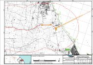
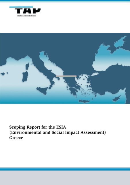
Figure 1.1 shows the <strong>TAP</strong> route <strong>in</strong> Greece. The figure shows the 2 km wide<br />
project corridor (1 km width either side of the proposed centrel<strong>in</strong>e).<br />
<strong>TAP</strong><br />
I<br />
GAL00-ERM-600-Y-TAE-0001
Figure 1.1<br />
<strong>TAP</strong> Route <strong>in</strong> Greece<br />
<strong>TAP</strong><br />
II<br />
GAL00-ERM-600-Y-TAE-0001
The base case route of the <strong>TAP</strong> <strong>in</strong> Greece is def<strong>in</strong>ed as a 2 km wide corridor at<br />
this stage of the project (see Figure 1.1). The corridor has been selected<br />
follow<strong>in</strong>g an extensive and thorough alternatives route assessment process<br />
per<strong>for</strong>med by <strong>TAP</strong> between mid 2010 and 2011 (see Section 3). The route<br />
ref<strong>in</strong>ement process has been completed <strong>for</strong> most of the base case route with<br />
the exception of an approximately 15 km long section between the town of<br />
Mesopotamia and the Greek/Albania border <strong>for</strong> which two alternatives have<br />
been identified, one cross<strong>in</strong>g the border west of the village of Dipotamia and<br />
one cross<strong>in</strong>g the border west of the village of Ieropigi (see Figure 1.1 and<br />
Appendix A). Similarly, the exact location of the compressor station near Nea<br />
Mesimvria is still under <strong>in</strong>vestigation (see Appendix A <strong>for</strong> the location of the<br />
two options currently under <strong>in</strong>vestigation).<br />
1.2 PURPOSE OF THIS REPORT<br />
<strong>TAP</strong>’s overall approach to Environmental Impact Assessment (EIA) will be<br />
per<strong>for</strong>med <strong>in</strong> compliance with Greek laws and regulations and with the<br />
European EIA Directive. Furthermore, the EIA will be per<strong>for</strong>med <strong>in</strong> l<strong>in</strong>e with<br />
applicable <strong>in</strong>ternational standards, as embodied <strong>in</strong> the European Bank <strong>for</strong><br />
Reconstruction and Development (EBRD) Per<strong>for</strong>mance Requirements (PR1-10).<br />
One of the requirements of the EIA process (from now on called<br />
Environmental and Social Impact Assessment (<strong>ESIA</strong>) <strong>in</strong> l<strong>in</strong>e with EBRD<br />
term<strong>in</strong>ology) is to carry out a <strong>Scop<strong>in</strong>g</strong> Study. This is a process by which<br />
stakeholders are consulted to contribute to the identification of key issues to<br />
be <strong>in</strong>vestigated as part of the <strong>ESIA</strong> itself.<br />
The first step <strong>in</strong> <strong>TAP</strong>’s <strong>ESIA</strong> process was to conduct an assessment of the<br />
possible route alternatives across Greece. Once the preferred alternative was<br />
identified, <strong>TAP</strong> commenced the <strong>Scop<strong>in</strong>g</strong> process with the aim to def<strong>in</strong>e the<br />
f<strong>in</strong>al scope and contents of the full <strong>ESIA</strong>, tak<strong>in</strong>g <strong>in</strong> account the <strong>in</strong>put from<br />
relevant stakeholders, and the specific requirements of the Greek Authorities<br />
and other stakeholders. This report presents the f<strong>in</strong>d<strong>in</strong>gs of the scop<strong>in</strong>g<br />
process.<br />
In order to comply with the Greek legislation, a Prelim<strong>in</strong>ary EIA (PEIA) and<br />
an <strong>ESIA</strong> will be prepared and submitted to the M<strong>in</strong>istry of Environment, Energy<br />
and Climate Change (MEECC) <strong>in</strong> due course. The PEIA is scheduled to be<br />
completed and submitted <strong>in</strong> July 2011, whilst the <strong>ESIA</strong> is estimated to be<br />
submitted to the authorities approximately 2 months follow<strong>in</strong>g the receipt of<br />
the decision on the PEIA.<br />
1.3 PROJECT DESCRIPTION<br />
1.3.1 Overview<br />
The <strong>TAP</strong> <strong>in</strong> Greece will be entirely onshore and will consist of an<br />
approximately 185km from Nea Mesimvria to the Greece/Albanian border.<br />
The pipel<strong>in</strong>e will be 48 <strong>in</strong>ches (1.219 m) <strong>in</strong> diameter. The pipel<strong>in</strong>e will be made<br />
<strong>TAP</strong><br />
III<br />
GAL00-ERM-600-Y-TAE-0001
of welded steel pipe sections which will range between 8 and 18 m <strong>in</strong> length.<br />
The steel pipe sections will be coated both <strong>in</strong>side and outside. The <strong>in</strong>ternal<br />
coat<strong>in</strong>g will be an epoxy res<strong>in</strong> which reduces friction, whilst the external<br />
coat<strong>in</strong>g will be 3-layer polyethylene to protect the pipel<strong>in</strong>e from corrosion.<br />
Some of the pipel<strong>in</strong>e sections will be additionally coated with re<strong>in</strong><strong>for</strong>ced<br />
concrete to protect the pipe from external damages. The entire pipel<strong>in</strong>e will be<br />
protected aga<strong>in</strong>st corrosion by a cathodic protection system.<br />
The pipel<strong>in</strong>e will be buried underground <strong>for</strong> the entire length. For safety<br />
reasons and <strong>in</strong> order to m<strong>in</strong>imise impacts to exist<strong>in</strong>g land uses (e.g.<br />
agricultural) the buried pipel<strong>in</strong>e will have a soil cover of m<strong>in</strong>imum one metre.<br />
Greater depth will be required when cross<strong>in</strong>g exist<strong>in</strong>g <strong>in</strong>frastructure. The <strong>TAP</strong><br />
pipel<strong>in</strong>e will be designed <strong>for</strong> a technical life time of 50 years. The design life<br />
<strong>for</strong> equipment and pip<strong>in</strong>g of the stations is 20 years. The design shall assure<br />
that the gas transport system fulfils all safety requirements of the base<br />
National and European Codes and Standards.<br />
The pipel<strong>in</strong>e <strong>in</strong>itial transportation capacity is characterised by a throughput of<br />
10 BCM/year but might be <strong>in</strong>creased to 20 BCM/year. For the 10 BCM phase<br />
only two Compressor Stations (CS1 <strong>in</strong> Greece and CS3 <strong>in</strong> Albania) are<br />
required. A third Station (CS2) will be added <strong>in</strong> case of <strong>in</strong>crease of the<br />
throughput from 10 BCM to 20 BCM, and will be located <strong>in</strong> Albania near the<br />
Albania/Greek border (near the town of Miras).<br />
The <strong>TAP</strong> project <strong>in</strong> Greece consists of the follow<strong>in</strong>g ma<strong>in</strong> components;<br />
onshore pipel<strong>in</strong>e, approximately 7 block valve stations, one compressor<br />
stations (CS1) and associated facilities required dur<strong>in</strong>g construction (access<br />
roads, camps, yards, etc.). <strong>TAP</strong> will need 6 temporary stock yards <strong>for</strong> the pipes<br />
and 3 worker camps.<br />
The pipel<strong>in</strong>e will be assembled <strong>in</strong> a conventional way by a construction<br />
spread that follows along the pipel<strong>in</strong>e corridor. First, the top soil is stripped<br />
away and stored separately and then a trench is excavated. Individual 8 to<br />
18 m long jo<strong>in</strong>ts of pipe are then welded to the pipel<strong>in</strong>e str<strong>in</strong>g which is<br />
subsequently lowered <strong>in</strong>to the trench. The soil is placed back <strong>in</strong>to the trench<br />
and the landscape re<strong>in</strong>stated while the construction spread moves <strong>for</strong>ward.<br />
The ma<strong>in</strong> limitations on land use above the pipel<strong>in</strong>e will be a narrow corridor<br />
of maximum 10 m (referred to as the Right of Way – RoW) <strong>in</strong> which the<br />
grow<strong>in</strong>g of deep rout<strong>in</strong>g trees will be restricted, a corridor of maximum 60 m<br />
<strong>in</strong> which the construction of houses will be restricted and a corridor of<br />
maximum 200 m <strong>in</strong> which the establishment of cluster of houses and/or<br />
<strong>in</strong>dustrial <strong>in</strong>frastructure is limited. The preferred route was selected to<br />
accommodate these criteria and allows sufficient space also <strong>for</strong> future<br />
developments of neighbour<strong>in</strong>g communities.<br />
To enhance pipel<strong>in</strong>e safety, the pipel<strong>in</strong>e will have approximately 7 block valve<br />
stations. With these valves the operator can isolate any segment of the l<strong>in</strong>e <strong>for</strong><br />
ma<strong>in</strong>tenance work or isolate a rupture or leak. The block valves are unmanned<br />
and conta<strong>in</strong> a small build<strong>in</strong>g with a fence around them to avoid any<br />
<strong>TAP</strong><br />
IV<br />
GAL00-ERM-600-Y-TAE-0001
<strong>in</strong>terference, cover<strong>in</strong>g a total surface area of approximately 20 x 30 m. In l<strong>in</strong>e<br />
with <strong>in</strong>ternational best practice, these stations will be <strong>in</strong>stalled <strong>in</strong> regular<br />
<strong>in</strong>tervals of around 30 km and the ma<strong>in</strong> equipment of such station will be<br />
<strong>in</strong>stalled underground.<br />
The compressor station is required to transport the gas by <strong>in</strong>creas<strong>in</strong>g the<br />
pressure. The compressor station will ma<strong>in</strong>ly comprise facilities <strong>for</strong> gas<br />
treatment (filter separators), meter<strong>in</strong>g, compression and cool<strong>in</strong>g. The size of<br />
the land plot required <strong>for</strong> the compressor station is estimated to be<br />
approximately 100 ha. The surface area required <strong>for</strong> the build<strong>in</strong>gs of the<br />
compressor station is approximately 2 ha. The rema<strong>in</strong><strong>in</strong>g portion of the 100 ha<br />
area will rema<strong>in</strong> empty as the compressor station will be positioned with<strong>in</strong><br />
this plot to ensure sufficient distance from other build<strong>in</strong>gs or <strong>in</strong>frastructure.<br />
Dur<strong>in</strong>g the operation the pipel<strong>in</strong>e will be monitored and controlled from a<br />
central control room at a location yet to be confirmed. Dur<strong>in</strong>g operation, leak<br />
detection will be by cont<strong>in</strong>uous measurements of pressure and flow rates at<br />
<strong>in</strong>let and outlet of the pipel<strong>in</strong>e. If a leak is detected, emergency shutdown<br />
procedures will be implemented. To allow <strong>in</strong>ternal <strong>in</strong>spection, pipe<br />
<strong>in</strong>spection gauges (pig) facilities will be <strong>in</strong>stalled. The pipel<strong>in</strong>e system has<br />
been designed to allow use of <strong>in</strong>strumented pigs, if necessary.<br />
1.4 BASELINE CONDITIONS<br />
In the east the project area comprises a large region with a mean altitude<br />
under 200 m; this is the Thessaloniki - Giannitsa Plateau which encompasses<br />
the downstream sections of four major river systems: Axios, Aliakmonas,<br />
Loudias and Gallikos. Most of the water bodies cross<strong>in</strong>g the plateau are<br />
heavily modified and are ma<strong>in</strong>ly used <strong>for</strong> irrigation.<br />
Vermio Mt. lies immediately west of the Thessaloniki - Giannitsa Plateau; its<br />
highest summit lies above the timberl<strong>in</strong>e (above 2,000 m a.s.l.). The western<br />
slopes of Vermio Mt. face the Eordea Plateau where major urban centres and<br />
<strong>in</strong>dustrial activities are present. The Eordea pla<strong>in</strong> lies between 400 – 800 m<br />
a.s.l. and is crossed by several tributaries of the Aliakmonas River or streams<br />
that flow <strong>in</strong>to the lake systems of the area (Chimaditida, Zazari, Petron and<br />
Vegoritida lakes). At the northwest of the Eordea plateau, Vernon (Vitsi) Mt.<br />
stands which cont<strong>in</strong>ues <strong>in</strong>to Askio (S<strong>in</strong>iatsiko) Mt. to the southeast and further<br />
south to Mt. Vour<strong>in</strong>os. The summits of both Vernon and Askio mounta<strong>in</strong>s rise<br />
above 2,000 m a.s.l. To the west towards the Greek-Albanian border and south<br />
of Kastoria Lake, the landscape is hilly with patches of cultivated land and<br />
grasslands as well as streams that flow <strong>in</strong>to the upstream section of<br />
Aliakmonas River.<br />
The study area hosts a variety of vegetation <strong>for</strong>mations from sea to alp<strong>in</strong>e<br />
level <strong>in</strong>clud<strong>in</strong>g evergreen and deciduous shrubland and <strong>for</strong>ests, riparian<br />
<strong>for</strong>ests, dry and wet grasslands and meadows, pastures and agricultural<br />
lands. The <strong>for</strong>est habitats found along the proposed route <strong>in</strong>clude beech<br />
<strong>for</strong>ests (F. sylvatica), mixed broadleaved <strong>for</strong>est dom<strong>in</strong>ated by oak (Quercus sp.)<br />
and coniferous <strong>for</strong>ests dom<strong>in</strong>ated by p<strong>in</strong>e (P<strong>in</strong>us nigra). Additionally, riparian<br />
<strong>TAP</strong><br />
V<br />
GAL00-ERM-600-Y-TAE-0001
<strong>for</strong>ests and galleries are found develop<strong>in</strong>g along rivers and streams<br />
throughout sections of the study area.<br />
The proposed pipel<strong>in</strong>e corridor and the work<strong>in</strong>g strip cross the Axios –<br />
Loudias - Aliakmonas Estuaries Natura 2000 site (GR 1220002; GR1220010).<br />
This area has been recognised as a wetland of major ornithological <strong>in</strong>terest<br />
s<strong>in</strong>ce the beg<strong>in</strong>n<strong>in</strong>g of the ‘70s and as such has also been declared a Ramsar<br />
site and a National Park. The proposed corridor (but not the work<strong>in</strong>g strip)<br />
crosses the northernmost portion of the National Park.<br />
The pipel<strong>in</strong>e route passes through two regions Central and <strong>West</strong>ern<br />
Macedonia, and 10 municipalities based on Kallikratis. There are 38 - 39<br />
settlements whose boundaries are with<strong>in</strong> the 2km corridor (depend<strong>in</strong>g on the<br />
alternative west of Mesopotamia). The most densely populated municipalities<br />
are located <strong>in</strong> the eastern section of the route (Pella, Chalkidona and<br />
Alexandreia). Land use along the route is predom<strong>in</strong>antly agricultural. State<br />
owned <strong>for</strong>est and some grassland make up most of the rema<strong>in</strong><strong>in</strong>g land. The<br />
area crossed by the eastern section of the route – from Nea Mesimvria through<br />
the municipalities of Chalkidona and Pella – is dom<strong>in</strong>ated by permanently<br />
irrigated agricultural land. As the route passes <strong>in</strong>to Skydra Municipality,<br />
agricultural activities are more diverse, <strong>in</strong>clud<strong>in</strong>g scattered permanent crops<br />
and cultivation of beans, tomatoes and cucumbers <strong>in</strong> covered greenhouses.<br />
From the border of Eordia Municipality until the settlement of Anatoliko, the<br />
corridor crosses concession areas <strong>for</strong> future exploration of lignite owned by<br />
the Public Power Corporation (PPC). <strong>West</strong> of the settlement of Polla Nera the<br />
pipel<strong>in</strong>e route passes <strong>in</strong>to a more mounta<strong>in</strong>ous area where the land is<br />
predom<strong>in</strong>antly <strong>for</strong>ested. Further to the west the area is ma<strong>in</strong>ly characterised<br />
by hilly terra<strong>in</strong> with agricultural areas and patches of <strong>for</strong>ests.<br />
1.5 POTENTIAL IMPACTS AND MITIGATION MEASURES<br />
The project’s environmental and socioeconomic impacts have been identified<br />
and prelim<strong>in</strong>arily assessed dur<strong>in</strong>g the scop<strong>in</strong>g process. The assessment has<br />
been based on the project <strong>in</strong><strong>for</strong>mation currently available, the basel<strong>in</strong>e<br />
<strong>in</strong><strong>for</strong>mation collected to date and the experience ga<strong>in</strong>ed <strong>in</strong> similar projects<br />
constructed <strong>in</strong> similar environmental and socioeconomic contexts. Mitigation<br />
and management measures have also been prelim<strong>in</strong>arily identified <strong>for</strong> each<br />
impact. The likelihood, magnitude and significance of the impacts identified<br />
dur<strong>in</strong>g the scop<strong>in</strong>g process will be further assessed <strong>in</strong> the detailed <strong>ESIA</strong>.<br />
Major environmental, socioeconomic and cultural heritage impacts have been<br />
avoided by means of an extensive route assessment which had the aim of<br />
select<strong>in</strong>g a route with the least impacts.<br />
Construction impacts of a pipel<strong>in</strong>e and associated facilities are typically<br />
temporary <strong>in</strong> nature and localised. The ma<strong>in</strong> permanent impacts are related to<br />
associated facilities. Construction impacts <strong>in</strong>clude temporary noise and air<br />
emissions from construction mach<strong>in</strong>ery, impacts on land use,<br />
loss/disturbance of natural habitats (flora and fauna). The magnitude and<br />
<strong>TAP</strong><br />
VI<br />
GAL00-ERM-600-Y-TAE-0001
significance of construction impacts will depend on the local conditions.<br />
Typically construction impacts can be managed and mitigated efficiently.<br />
The pipel<strong>in</strong>e will be buried and the land will be re-<strong>in</strong>stated to its preconstruction<br />
status. The ma<strong>in</strong> limitations on land use above the pipel<strong>in</strong>e will<br />
be a narrow corridor of maximum 10 m <strong>in</strong> which the grow<strong>in</strong>g of deep rout<strong>in</strong>g<br />
trees will be restricted, a corridor of maximum 60 m <strong>in</strong> which the construction<br />
of houses will be restricted and a corridor of maximum 200 m <strong>in</strong> which the<br />
establishment of cluster of houses and/or <strong>in</strong>dustrial <strong>in</strong>frastructure is limited.<br />
The preferred route was selected to accommodate these criteria and allows<br />
sufficient space also <strong>for</strong> future developments of neighbour<strong>in</strong>g communities.<br />
The operation of the compressor station will generate air emissions and noise<br />
and will have an impact on the landscape. The magnitude and significance of<br />
these impacts are comparable to those of small co-generation gas power<br />
plants. Best practice and mitigation measures will be adopted to m<strong>in</strong>imise<br />
operational impacts. Landscape impacts will be managed through the<br />
restoration of the orig<strong>in</strong>al landscape along the pipel<strong>in</strong>e route and through<br />
vegetation screen<strong>in</strong>g of the permanent structures where required.<br />
1.6 TERMS OF REFERENCE FOR <strong>ESIA</strong><br />
<strong>TAP</strong> will per<strong>for</strong>m a PEIA and an <strong>ESIA</strong> to be conducted <strong>in</strong> accordance with<br />
Greek requirements. The ma<strong>in</strong> steps <strong>for</strong> the detailed <strong>ESIA</strong> <strong>in</strong>clude:<br />
• Update and f<strong>in</strong>alise the technical project description as further<br />
eng<strong>in</strong>eer<strong>in</strong>g details become available;<br />
• Conduct additional consultation and further ref<strong>in</strong>e the scope of the <strong>ESIA</strong><br />
as necessary;<br />
• Collect additional basel<strong>in</strong>e data through desktop research and field<br />
studies to complete a comprehensive description of the environmental,<br />
social and cultural heritage conditions;<br />
• Develop mitigation and enhancement measures and outl<strong>in</strong>e an<br />
Environmental and Social Management Plan (ESMP) <strong>in</strong>clud<strong>in</strong>g an<br />
approach <strong>for</strong> monitor<strong>in</strong>g;<br />
• <strong>Report</strong> f<strong>in</strong>d<strong>in</strong>gs <strong>in</strong> a comprehensive <strong>ESIA</strong> report.<br />
To develop a complete understand<strong>in</strong>g of the exist<strong>in</strong>g environmental and social<br />
conditions of the project’s area of <strong>in</strong>fluence and assess the impacts, further<br />
desktop and field studies will be carried out. These tasks will be per<strong>for</strong>med<br />
by an <strong>in</strong>terdiscipl<strong>in</strong>ary team of local Greek and <strong>in</strong>ternational qualified<br />
specialists.<br />
Field studies will <strong>in</strong>clude sampl<strong>in</strong>g and analyses of soil samples, surface and<br />
groundwater, river sediments, air quality and ambient noise levels. In<br />
addition environmental (flora, fauna, habitats, vegetation), socioeconomic<br />
(stakeholder engagement, household surveys, etc.) and cultural heritage<br />
surveys will be per<strong>for</strong>med.<br />
<strong>TAP</strong><br />
VII<br />
GAL00-ERM-600-Y-TAE-0001
1.7 STAKEHOLDER ENGAGEMENT<br />
Consultation and engagement with stakeholders is an <strong>in</strong>tegral part of the<br />
Environmental and Social Impact Assessment (<strong>ESIA</strong>) process. In l<strong>in</strong>e with this,<br />
<strong>TAP</strong> has prepared a Stakeholder Engagement Strategy whose overall aim is to<br />
ensure that a consistent, comprehensive, coord<strong>in</strong>ated and culturally<br />
appropriate approach is taken <strong>for</strong> consultation and project disclosure. The<br />
approach taken by <strong>TAP</strong> is <strong>in</strong> full compliance with Greek EIA Regulations,<br />
EBRD Per<strong>for</strong>mance Requirements, as well as relevant policies of the IFC and<br />
World Bank. <strong>TAP</strong> <strong>in</strong>tends to undertake a process of stakeholder engagement<br />
through the phases of project plann<strong>in</strong>g, construction, operation and<br />
decommission<strong>in</strong>g. The plan <strong>for</strong> this engagement, <strong>in</strong>clud<strong>in</strong>g identification of<br />
stakeholders (i.e. people and organisations who have a role <strong>in</strong> the project or<br />
could be affected by the project activities or who are <strong>in</strong>terested <strong>in</strong> the project)<br />
and disclosure of <strong>in</strong><strong>for</strong>mation, consultation, and handl<strong>in</strong>g of suggestions,<br />
comments and concerns, is documented <strong>in</strong> the Greece Stakeholder<br />
Engagement Plan. This plan will be updated as required as the project<br />
progresses.<br />
The Project’s <strong>ESIA</strong> and Stakeholder Consultation Schedule is reported <strong>in</strong> Table<br />
1.1 below.<br />
Table 1.1<br />
<strong>ESIA</strong> and Stakeholder Consultation Schedule<br />
Activity<br />
Tim<strong>in</strong>g<br />
Start<br />
F<strong>in</strong>ish<br />
Submission of <strong>Scop<strong>in</strong>g</strong> <strong>Report</strong>* June 2011<br />
Route Ref<strong>in</strong>ement Disclosure and<br />
June 2011 July 2011<br />
<strong>Scop<strong>in</strong>g</strong> Validation*<br />
Submission of F<strong>in</strong>al PEIA to<br />
July 2011<br />
Authorities<br />
PEIA Consultation (estimate) September 2011 February 2012<br />
<strong>ESIA</strong> Specialist Field Surveys June 2011 October 2011<br />
<strong>ESIA</strong> Phase Consultation<br />
(<strong>in</strong>clud<strong>in</strong>g house hold surveys)<br />
Submission of F<strong>in</strong>al <strong>ESIA</strong> to<br />
Authorities<br />
September 2011 October 2011<br />
Approximately 2 months<br />
follow<strong>in</strong>g the approval<br />
of the PEIA<br />
<strong>ESIA</strong> Consultation (estimate) May 2012 October 2012<br />
Note: * Voluntary step. Per<strong>for</strong>med by <strong>TAP</strong> to ensure compliance with the EBRD Per<strong>for</strong>mance<br />
Requirements<br />
1.8 PUBLIC COMMENTS AND SUGGESTIONS<br />
An important objective of the <strong>ESIA</strong> <strong>Scop<strong>in</strong>g</strong> disclosure process is to allow<br />
stakeholders to provide feedback on the Project. There<strong>for</strong>e, <strong>TAP</strong> has envisaged<br />
a process that allows stakeholders to address their comments and suggestions<br />
<strong>in</strong> writ<strong>in</strong>g to <strong>TAP</strong> after the scop<strong>in</strong>g meet<strong>in</strong>gs have taken place.<br />
In this regard, <strong>TAP</strong> would like to <strong>in</strong>vite all stakeholders <strong>in</strong>volved <strong>in</strong> the<br />
scop<strong>in</strong>g process, <strong>in</strong>clud<strong>in</strong>g local communities and the general public, to<br />
<strong>TAP</strong><br />
VIII<br />
GAL00-ERM-600-Y-TAE-0001
submit <strong>in</strong> writ<strong>in</strong>g their comments and suggestion concern<strong>in</strong>g the Greek<br />
section of the <strong>Trans</strong> <strong>Adriatic</strong> Pipel<strong>in</strong>e (<strong>TAP</strong>) until 15 th of August 2011.<br />
Appendix B presents a standard <strong>for</strong>m to facilitate the submission of comments<br />
and suggestions <strong>in</strong> both <strong>English</strong> and Greek. Participants to the scop<strong>in</strong>g<br />
meet<strong>in</strong>gs as well as the general public <strong>in</strong>terested <strong>in</strong> the project will be <strong>in</strong>vited<br />
to submit comment <strong>for</strong>ms either via mail or e-mail to the follow<strong>in</strong>g address:<br />
<strong>Trans</strong> <strong>Adriatic</strong> Pipel<strong>in</strong>e AG – Greece (Branch Office)<br />
21st Floor, Athens Tower, 2-4 Messogion Ave.,11527<br />
Athens, Greece<br />
Phone: + 30 210 7454613<br />
Fax: + 30 210 7454300<br />
www.trans-adriatic-pipel<strong>in</strong>e.com<br />
esia-comments@tap-ag.com<br />
<strong>TAP</strong><br />
IX<br />
GAL00-ERM-600-Y-TAE-0001
INDEX<br />
EXECUTIVE SUMMARY<br />
1 INTRODUCTION 1<br />
1.1 OVERVIEW OF THE PROJECT 1<br />
1.2 THE PROJECT’S ENVIRONMENTAL AND SOCIAL IMPACT ASSESSMENT (<strong>ESIA</strong>)<br />
PROCESS 3<br />
1.2.1 Introduction 3<br />
1.2.2 <strong>TAP</strong>’s Approach to <strong>Scop<strong>in</strong>g</strong> 6<br />
1.3 SCOPING REPORT STRUCTURE 7<br />
2 REGULATIONS AND GUIDELINES 8<br />
2.1 GREEK AND EUROPEAN LEGAL FRAMEWORK FOR ENVIRONMENTAL IMPACT<br />
ASSESSMENT (EIA) 8<br />
2.1.1 Introduction 8<br />
2.1.2 Prelim<strong>in</strong>ary EIA (PEIA) 9<br />
2.1.3 <strong>ESIA</strong> 9<br />
2.2 EBRD PERFORMANCE REQUIREMENTS ON ENVIRONMENTAL AND SOCIAL<br />
IMPACT ASSESSMENT 10<br />
2.3 <strong>ESIA</strong> RELATED INTERNATIONAL CONVENTIONS/AGREEMENTS 14<br />
3 DESCRIPTION OF SELECTED OPTIONS 15<br />
3.1 INTRODUCTION 15<br />
3.2 METHODOLOGY OF ALTERNATIVES ASSESSMENT PROCESS 15<br />
3.3 FINDINGS OF THE ALTERNATIVES ASSESSMENT 16<br />
3.3.1 Compressor Stations 18<br />
4 PROJECT DESCRIPTION 19<br />
4.1 INTRODUCTION 19<br />
4.1.1 General Description 19<br />
4.1.2 Safety 20<br />
4.2 PIPELINE 20<br />
4.2.1 Introduction 20<br />
4.2.2 Pipel<strong>in</strong>e Construction 20<br />
4.2.3 Pre-Commission<strong>in</strong>g 24<br />
4.2.4 Operation 25<br />
4.2.5 Decommission<strong>in</strong>g 25<br />
5 BASELINE CONDITIONS 26<br />
5.1 INTRODUCTION 26<br />
5.2 ENVIRONMENT 26<br />
5.2.1 Climatic Conditions 26<br />
5.2.2 Geography 26<br />
<strong>TAP</strong><br />
a<br />
GAL00-ERM-600-Y-TAE-0001
5.2.3 Geology 27<br />
5.2.4 Vegetation and Flora 27<br />
5.2.5 Fauna 28<br />
5.2.6 Protected Areas 29<br />
5.2.7 Landscape 30<br />
5.3 SOCIO ECONOMIC 30<br />
5.3.1 Introduction 30<br />
5.3.2 Socio-economic Context 31<br />
5.4 CULTURAL HERITAGE 33<br />
6 POTENTIAL IMPACTS AND MITIGATION MEASURES 34<br />
6.1 INTRODUCTION 34<br />
6.2 PIPELINE 36<br />
6.2.1 Construction 36<br />
6.2.2 Operation and Decommission<strong>in</strong>g 44<br />
6.3 MAIN FINDINGS OF PRELIMINARY ASSESSMENT 48<br />
7 TERMS OF REFERENCE FOR <strong>ESIA</strong> 49<br />
7.1 INTRODUCTION 49<br />
7.2 <strong>ESIA</strong> OBJECTIVES 49<br />
7.3 <strong>ESIA</strong> STEPS 49<br />
7.4 SPECIALIST STUDIES 50<br />
7.4.1 Desktop Studies 50<br />
7.4.2 Field Studies 50<br />
7.5 STAKEHOLDER ENGAGEMENT 51<br />
7.5.1 PEIA Stage Consultation 51<br />
7.5.2 <strong>ESIA</strong> Phase Consultation 51<br />
7.5.3 <strong>ESIA</strong> <strong>Report</strong> Disclosure 52<br />
7.6 TENTATIVE TABLE OF CONTENT OF PEIA 52<br />
7.7 STRUCTURE OF THE <strong>ESIA</strong> REPORT 53<br />
7.8 PROVISIONAL SCOPING, PEIA AND <strong>ESIA</strong> SCHEDULE 54<br />
8 STAKEHOLDER ENGAGEMENT 55<br />
8.1 INTRODUCTION 55<br />
8.2 STAKEHOLDER ENGAGEMENT PHASES FOR <strong>TAP</strong> PROJECT 55<br />
8.2.1 Overview 55<br />
8.2.2 Pre-scop<strong>in</strong>g Consultation 56<br />
8.3 SCOPING PHASE STAKEHOLDER ENGAGEMENT 57<br />
8.3.1 Objectives 57<br />
8.3.2 Stakeholder Engagement Activities 58<br />
8.4 GRIEVANCE MECHANISM 61<br />
<strong>TAP</strong><br />
b<br />
GAL00-ERM-600-Y-TAE-0001
LIST OF APPENDICES<br />
APPENDIX A – Maps<br />
APPENDIX B – Comments Form<br />
APPENDIX C – List of Stakeholders<br />
APPENDIX D – <strong>ESIA</strong> Action Plan<br />
LIST OF TABLES<br />
Table 1.1<br />
Table 2.1<br />
Table 2.2<br />
Table 2.3<br />
Table 3.1<br />
Table 6.1<br />
Table 6.2<br />
Table 6.3<br />
Table 6.4<br />
Table 6.5<br />
Table 6.6<br />
Table 7.1<br />
Table 7.2<br />
Table 7.3<br />
Table 8.1<br />
Table 8.2<br />
Table 8.3<br />
Summary of the <strong>ESIA</strong> Process<br />
Greek Legal Framework on Environmental Impact Assessment<br />
EBRD Per<strong>for</strong>mance Requirements<br />
International Conventions and Agreements Signed/Ratified by<br />
Greece <strong>in</strong> Relation to the <strong>ESIA</strong> Process<br />
Ma<strong>in</strong> Environmental, Socioeconomic and Cultural Heritage<br />
Characteristics of Alternatives N1 and S0<br />
Potential Environmental Impacts and Mitigation Measures<br />
Related to Pipel<strong>in</strong>e Construction and Pre-Commission<strong>in</strong>g<br />
Potential Socioeconomic Impacts and Mitigation Measures<br />
related to Pipel<strong>in</strong>e Construction and Pre-Commission<strong>in</strong>g<br />
Potential Cultural Heritage Impacts and Mitigation Measures<br />
related to Pipel<strong>in</strong>e Construction and Pre-Commission<strong>in</strong>g<br />
Potential Environmental Impacts and Mitigation Measures<br />
related to Pipel<strong>in</strong>e Operation and Decommission<strong>in</strong>g<br />
Potential Socioeconomic Impacts and Mitigation Measures<br />
related to Pipel<strong>in</strong>e Operation and Decommission<strong>in</strong>g<br />
Potential Cultural Heritage Impacts and Mitigation Measures<br />
related to Pipel<strong>in</strong>e Operation and Decommission<strong>in</strong>g<br />
Tentative PEIA <strong>Report</strong> Structure<br />
Tentative <strong>ESIA</strong> <strong>Report</strong> Structure<br />
<strong>ESIA</strong> and Stakeholder Consultation Schedule<br />
<strong>ESIA</strong> Stakeholder Engagement Phases<br />
Key Stakeholder Groups <strong>for</strong> <strong>Scop<strong>in</strong>g</strong> Phase Engagement<br />
<strong>Scop<strong>in</strong>g</strong> Meet<strong>in</strong>gs<br />
LIST OF FIGURES<br />
Figure 1.1 <strong>TAP</strong> Route <strong>in</strong> Greece<br />
Figure 1.2 Schematics of the <strong>ESIA</strong> Process<br />
Figure 4.1 Regular Work<strong>in</strong>g Strip<br />
Figure 4.2 Reduced Work<strong>in</strong>g Strip<br />
Figure 4.3 Compressor Station - Typical Layout<br />
<strong>TAP</strong><br />
c<br />
GAL00-ERM-600-Y-TAE-0001
ACRONYMS AND ABBREVIATIONS<br />
AOX<br />
ASCIs<br />
BAP<br />
BAT<br />
BCM<br />
BOD<br />
BV(S)<br />
CEP<br />
CLO<br />
COD<br />
CORINE<br />
CS<br />
DESFA<br />
DO<br />
EBE<br />
EBRD<br />
ENT<br />
ERM<br />
ESD<br />
<strong>ESIA</strong><br />
ESMP<br />
ESMP FEED<br />
EU<br />
GIS<br />
GPS<br />
HSE<br />
IBC<br />
ICH<br />
IUCN<br />
Kp<br />
masl<br />
MEECC<br />
NGO<br />
PAH<br />
PCBs<br />
PEIA<br />
PIG<br />
QRA<br />
RAP<br />
REAs<br />
RoW<br />
SEP<br />
<strong>TAP</strong><br />
<strong>TAP</strong><br />
TOC<br />
TOM<br />
TPH<br />
UXO<br />
Absorbable Organic Halides<br />
Areas of Special Conservation Interest<br />
Biodiversity Action Plan<br />
Best Available Technique<br />
Billion Cubic Meters<br />
Biological Oxygen Demand<br />
Block Valve (Station)<br />
Community Engagement Plan<br />
Community Liaison Officer<br />
Chemical Oxygen Demand<br />
Coord<strong>in</strong>ation of In<strong>for</strong>mation on the Environment<br />
Compressor Station<br />
Hellenic Gas <strong>Trans</strong>mission System Operator<br />
Dissolved Oxygen<br />
Extended Basic Eng<strong>in</strong>eer<strong>in</strong>g<br />
European Bank <strong>for</strong> Reconstruction and Development<br />
E.ON New Build & Technology GmbH<br />
Environmental Resources Management<br />
<strong>ESIA</strong> <strong>Scop<strong>in</strong>g</strong> Document<br />
Environmental and Social Impact Assessment<br />
Environmental and Social Management Plan<br />
Environmental and Social Management Plan Front End Eng<strong>in</strong>eer<strong>in</strong>g Design<br />
European Union<br />
Geographic In<strong>for</strong>mation System<br />
Global Position<strong>in</strong>g System<br />
Health, Safety and Environment<br />
International Build<strong>in</strong>g Code<br />
Intangible Cultural Heritage<br />
International Union <strong>for</strong> Conservation of Nature<br />
Kilometre Po<strong>in</strong>t<br />
Meters Above Sea Level<br />
M<strong>in</strong>istry of Environment, Energy and Climate Change<br />
Nongovernmental Organisations<br />
Polycyclic Aromatic Hydrocarbons<br />
Polychloro Byphenils<br />
Prelim<strong>in</strong>ary Environmental Impact Assessment<br />
Pipe Inspection Gauges<br />
Quantitative Risk Assessment<br />
Resettlement Action Plan<br />
Regional Environmental Agencies<br />
Right of Way<br />
Stakeholder Engagement Plan<br />
<strong>Trans</strong> <strong>Adriatic</strong> Pipel<strong>in</strong>e<br />
Client<br />
Total Organic Carbon<br />
Total Organic Matter<br />
Total Petroleum Hydrocarbons<br />
Unexploded Ord<strong>in</strong>ance<br />
<strong>TAP</strong><br />
d<br />
GAL00-ERM-600-Y-TAE-0001
1 INTRODUCTION<br />
1.1 OVERVIEW OF THE PROJECT<br />
The <strong>Trans</strong> <strong>Adriatic</strong> Pipel<strong>in</strong>e (<strong>TAP</strong>) is a proposed pipel<strong>in</strong>e <strong>in</strong> the Southern Gas<br />
Corridor that will br<strong>in</strong>g gas from new sources <strong>in</strong> the Caspian region to<br />
<strong>West</strong>ern and South Eastern Europe.<br />
The 520 km pipel<strong>in</strong>e will connect to exist<strong>in</strong>g gas networks and start <strong>in</strong> Greece,<br />
cross Albania and the <strong>Adriatic</strong> Sea and come ashore <strong>in</strong> southern Italy,<br />
allow<strong>in</strong>g gas to flow directly from the Caspian bas<strong>in</strong> <strong>in</strong>to European markets.<br />
<strong>TAP</strong>’s shareholders are Swiss EGL (42.5%), Norwegian Statoil (42.5%) and<br />
German E.ON Ruhrgas (15%).<br />
<strong>TAP</strong> will contribute to the security and diversity of Europe’s energy supply by<br />
provid<strong>in</strong>g the necessary <strong>in</strong>frastructure to transport gas from the Shah Deniz II<br />
field <strong>in</strong> Azerbaijan via the most direct route to Southern Europe once<br />
production beg<strong>in</strong>s <strong>in</strong> early 2017. As more gas becomes available, <strong>TAP</strong> will<br />
have the capacity to cater <strong>for</strong> an additional 10 Billion Cubic Meters (BCM) per<br />
annum of new gas, expand<strong>in</strong>g to 20 BCM as required.<br />
<strong>TAP</strong> is supported by f<strong>in</strong>ancially stable/strong shareholders. <strong>TAP</strong> will require<br />
no fund<strong>in</strong>g from subsidies or from any of the governments of the host<br />
countries. <strong>TAP</strong> can deliver substantial benefits <strong>in</strong> terms of significant<br />
<strong>in</strong>vestment to the countries which it passes through. The European Union<br />
recognised the project under the so-called TEN-E (<strong>Trans</strong>-European Energy<br />
Networks) guidel<strong>in</strong>es as a Project of Common Interest <strong>for</strong> the European<br />
Union’s overall energy policy objectives.<br />
The pipel<strong>in</strong>e through Greece would <strong>in</strong>itially consist of an approximately<br />
185 km long pipel<strong>in</strong>e and a compressor station near Nea Mesimvria (also<br />
referred to as CS1) with a capacity of 10 BCM of natural gas per year (around<br />
1.520.000 cubic metres per hour).<br />
In l<strong>in</strong>e with <strong>in</strong>ternational best practice, block valve stations will be <strong>in</strong>stalled<br />
approximately every 30 km of the pipel<strong>in</strong>e to <strong>in</strong>terrupt the gas flow <strong>in</strong> case of<br />
ma<strong>in</strong>tenance or emergency. At a later stage the throughput capacity of the<br />
pipel<strong>in</strong>e will be <strong>in</strong>creased from 10 to 20 BCM per year (from 1.520.000 to<br />
3.040.000 cubic meters per hour). The <strong>in</strong>crease of throughput capacity will be<br />
obta<strong>in</strong>ed through the <strong>in</strong>stallation of a compressor station <strong>in</strong> Albania, near the<br />
Greek border (close to the town of Miras). The closest Greek town to the<br />
compressor station is Dipotamia.<br />
Figure 1.1 shows the <strong>TAP</strong> route <strong>in</strong> Greece. The figure shows the 2 km wide<br />
project corridor (1 km width either side of the proposed centrel<strong>in</strong>e).<br />
<strong>TAP</strong><br />
1<br />
GAL00-ERM-600-Y-TAE-0001
Figure 1.1<br />
<strong>TAP</strong> Route <strong>in</strong> Greece<br />
<strong>TAP</strong><br />
2<br />
GAL00-ERM-600-Y-TAE-0001
The base case route of the <strong>TAP</strong> <strong>in</strong> Greece is def<strong>in</strong>ed as a 2 km wide corridor at<br />
this stage of the project (see Figure 1.1). The corridor has been selected<br />
follow<strong>in</strong>g an extensive and thorough alternatives route assessment process<br />
per<strong>for</strong>med by <strong>TAP</strong> between mid 2010 and 2011 (see Section 3). The route<br />
ref<strong>in</strong>ement process has been completed <strong>for</strong> most of the base case route with<br />
the exception of an approximately 15 km long section between the town of<br />
Mesopotamia and the Greek/Albania border <strong>for</strong> which two alternatives have<br />
been identified, one cross<strong>in</strong>g the border west of the village of Dipotamia and<br />
one cross<strong>in</strong>g the border west of the village of Ieropigi (see Figure 1.1 and<br />
Appendix A). Similarly, the exact location of the compressor station near Nea<br />
Mesimvria is still under <strong>in</strong>vestigation (see Appendix A <strong>for</strong> the location of the<br />
two options currently under <strong>in</strong>vestigation).<br />
1.2 THE PROJECT’S ENVIRONMENTAL AND SOCIAL IMPACT ASSESSMENT (<strong>ESIA</strong>)<br />
PROCESS<br />
1.2.1 Introduction<br />
<strong>TAP</strong>’s overall approach to <strong>ESIA</strong> will be <strong>in</strong> compliance with Greek regulations<br />
and will be per<strong>for</strong>med <strong>in</strong> l<strong>in</strong>e with the requirements of the European EIA<br />
Directive and applicable <strong>in</strong>ternational standards, as embodied <strong>in</strong> the European<br />
Bank <strong>for</strong> Reconstruction and Development (EBRD) Per<strong>for</strong>mance Requirements (PR1-<br />
10). The requirements of the Espoo Convention (Environmental Impact<br />
Assessment <strong>in</strong> a <strong>Trans</strong>boundary Context) and the Aarhus Convention (Access<br />
to In<strong>for</strong>mation Public Participation <strong>in</strong> Decision-mak<strong>in</strong>g and Access to Justice<br />
<strong>in</strong> Environmental Matters) will also be met (see Section 2.2).<br />
The first step <strong>in</strong> <strong>TAP</strong>’s <strong>ESIA</strong> process was to conduct an assessment of the<br />
possible route alternatives across Greece <strong>in</strong> mid 2010. The extensive and<br />
thorough alternatives route assessment process commenced <strong>in</strong> late 2010 with<br />
the aim to select a technically feasible pipel<strong>in</strong>e route with the least<br />
environmental, socioeconomic and cultural heritage impacts (please see<br />
Section 3). Once the preferred alternative was identified, <strong>TAP</strong> commenced the<br />
<strong>Scop<strong>in</strong>g</strong> process with the aim to def<strong>in</strong>e the required scope of the <strong>ESIA</strong>. This<br />
report presents the f<strong>in</strong>d<strong>in</strong>gs of the scop<strong>in</strong>g process.<br />
S<strong>in</strong>ce the commencement of the alternatives assessment process <strong>TAP</strong> has<br />
engaged with stakeholders with the aim to seek the views of <strong>in</strong>terested parties<br />
so that these can be taken <strong>in</strong>to account <strong>in</strong> the project design and<br />
implementation. This engagement has cont<strong>in</strong>ued throughout the scop<strong>in</strong>g<br />
process (see Section 8) and will cont<strong>in</strong>ue throughout the Project life cycle.<br />
Figure 1.2 graphically presents the <strong>ESIA</strong> process. The scop<strong>in</strong>g phase and <strong>ESIA</strong><br />
activities are briefly described <strong>in</strong> Table 1.1.<br />
<strong>TAP</strong><br />
3<br />
GAL00-ERM-600-Y-TAE-0001
Figure 1.2<br />
Schematics of the <strong>ESIA</strong> Process<br />
Table 1.1<br />
Summary of the <strong>ESIA</strong> Process<br />
Step<br />
Screen<strong>in</strong>g<br />
Alternatives Assessment<br />
<strong>Scop<strong>in</strong>g</strong><br />
Description<br />
Screen<strong>in</strong>g is per<strong>for</strong>med to determ<strong>in</strong>e if the project requires a<br />
summary EIA or a detailed EIA<br />
Assessment of alternatives with the aim to identify the project<br />
alternative with the least environmental and social impacts.<br />
<strong>Scop<strong>in</strong>g</strong> identifies the key issues to be addressed <strong>in</strong> the <strong>ESIA</strong>.<br />
<strong>Scop<strong>in</strong>g</strong>, as presented <strong>in</strong> this report, will ensure that the process is<br />
focused on the potentially significant environmental and social<br />
impacts which may arise from the project. It will take <strong>in</strong>to account<br />
the results of consultations undertaken to date on the project.<br />
Ultimately scop<strong>in</strong>g def<strong>in</strong>es the scope of work of the <strong>ESIA</strong>, <strong>in</strong>clud<strong>in</strong>g<br />
stakeholder engagement.<br />
<strong>TAP</strong><br />
4<br />
GAL00-ERM-600-Y-TAE-0001
Step<br />
PEIA<br />
Basel<strong>in</strong>e Studies<br />
Impact assessment and<br />
mitigation measures<br />
Environmental and social<br />
management plans<br />
Stakeholder Engagement<br />
and Consultation<br />
Description<br />
The PEIA, which is specific to the Greek environmental permitt<strong>in</strong>g<br />
system, has been designed to <strong>in</strong>corporate the screen<strong>in</strong>g and scop<strong>in</strong>g<br />
steps of the EU EIA process. In essence, the PEIA goes beyond<br />
scop<strong>in</strong>g, with the aim to provide the competent authorities with<br />
sufficient <strong>in</strong><strong>for</strong>mation <strong>in</strong> order to make an <strong>in</strong><strong>for</strong>med prelim<strong>in</strong>ary<br />
plann<strong>in</strong>g decision.<br />
Accord<strong>in</strong>g to Law1391B/29-9-2003 "Determ<strong>in</strong>ation of public<br />
participation, <strong>in</strong><strong>for</strong>mation and consultation dur<strong>in</strong>g the <strong>ESIA</strong><br />
process", public consultation falls under the jurisdiction of MEECC<br />
and competent authorities. MEECC and competent authorities<br />
<strong>in</strong><strong>for</strong>m the public after the submission of PEIA, giv<strong>in</strong>g a 35days<br />
timeframe <strong>for</strong> submitt<strong>in</strong>g any comments. There is no statutory<br />
requirement <strong>for</strong> stakeholder engagement dur<strong>in</strong>g the PEIA.<br />
For the key issues identified <strong>in</strong> scop<strong>in</strong>g, available <strong>in</strong><strong>for</strong>mation on<br />
the exist<strong>in</strong>g environmental and social conditions (also referred to as<br />
basel<strong>in</strong>e conditions) will be gathered. This will be supplemented by<br />
field studies and surveys where necessary. The future development<br />
of the basel<strong>in</strong>e conditions <strong>in</strong> the absence of the project will also be<br />
considered.<br />
This stage is focused on predict<strong>in</strong>g environmental and social<br />
changes from the basel<strong>in</strong>e as a result of the project’s activities<br />
(consider<strong>in</strong>g the entire lifecycle of the project). Each impact will<br />
then be evaluated to determ<strong>in</strong>e its significance <strong>for</strong> the environment<br />
and society. Where necessary measures will be proposed to<br />
mitigate significant impacts.<br />
The various mitigation measures will be presented <strong>in</strong> an<br />
Environmental and Social Management Plan (ESMP), describ<strong>in</strong>g<br />
how measures will be implemented throughout the different<br />
project phases. The ESMP will detail the resources and<br />
responsibilities <strong>for</strong> implementation, the tim<strong>in</strong>g and monitor<strong>in</strong>g and<br />
audit plans to ensure all the mitigation commitments are met. It<br />
will also identify any requirements <strong>for</strong> tra<strong>in</strong><strong>in</strong>g and other capacity<br />
build<strong>in</strong>g. The ESMP will <strong>in</strong>clude a Livelihood Restoration Plan and<br />
a Resettlement Action Plan detail<strong>in</strong>g how land acquisition and<br />
easment will be managed <strong>in</strong> accordance with <strong>TAP</strong> policy and<br />
<strong>in</strong>ternational good practice.<br />
Dur<strong>in</strong>g the <strong>ESIA</strong> studies the team will seek the views of <strong>in</strong>terested<br />
parties so that these can be taken <strong>in</strong>to account <strong>in</strong> the assessment<br />
and reflected <strong>in</strong> the proposals <strong>for</strong> mitigation. Once complete, the<br />
<strong>ESIA</strong> <strong>Report</strong> will be subject to public disclosure and consultation.<br />
Comments will be taken <strong>in</strong>to account <strong>in</strong> revis<strong>in</strong>g the f<strong>in</strong>al <strong>ESIA</strong><br />
<strong>Report</strong> and ESMP.<br />
<strong>TAP</strong><br />
5<br />
GAL00-ERM-600-Y-TAE-0001
1.2.2 <strong>TAP</strong>’s Approach to <strong>Scop<strong>in</strong>g</strong><br />
In order to comply with the Greek legislation a PEIA and an <strong>ESIA</strong> will be<br />
prepared and submitted to the M<strong>in</strong>istry of Environment, Energy and Climate<br />
Change (MEECC) <strong>in</strong> due course. The PEIA is scheduled to be completed and<br />
submitted <strong>in</strong> July 2011, whilst the <strong>ESIA</strong> is estimated to be submitted to the<br />
authorities approximately 2 months follow<strong>in</strong>g the receipt of the decision on<br />
the PEIA. The PEIA, which is specific to the Greek environmental permitt<strong>in</strong>g<br />
system, has been designed to <strong>in</strong>corporate the screen<strong>in</strong>g and scop<strong>in</strong>g steps of<br />
the EU EIA process. In essence, the PEIA goes beyond scop<strong>in</strong>g, with the aim to<br />
provide the competent authorities with sufficient <strong>in</strong><strong>for</strong>mation <strong>in</strong> order to<br />
make an <strong>in</strong><strong>for</strong>med prelim<strong>in</strong>ary plann<strong>in</strong>g decision.<br />
This scop<strong>in</strong>g report has been prepared to ensure full compliance with the<br />
EBRD Per<strong>for</strong>mance Requirements, particularly with PR 1 Environmental and<br />
Social Appraisal and Management and PR 10 In<strong>for</strong>mation Disclosure and<br />
Stakeholder Engagement. As such this scop<strong>in</strong>g report is the outcome of a<br />
voluntary step which has been per<strong>for</strong>med with the aim to:<br />
1. Identify people or communities that are or could be affected by the project,<br />
as well as other <strong>in</strong>terested parties;<br />
2. Ensure that such stakeholders are appropriately engaged on<br />
environmental and social issues that could potentially affect them through<br />
a process of <strong>in</strong><strong>for</strong>mation disclosure and mean<strong>in</strong>gful consultation;<br />
3. Ma<strong>in</strong>ta<strong>in</strong> a constructive relationship with stakeholders on an ongo<strong>in</strong>g<br />
basis through mean<strong>in</strong>gful engagement dur<strong>in</strong>g the different phases of the<br />
project (e.g. alternatives assessment, scop<strong>in</strong>g, PEIA, <strong>ESIA</strong> and project<br />
implementation);<br />
4. Prelim<strong>in</strong>arily identify and assess environmental and social impacts and<br />
issues, both adverse and beneficial, associated with the project;<br />
5. Identify measures to avoid, or where avoidance is not possible, m<strong>in</strong>imise,<br />
mitigate, or offset/compensate <strong>for</strong> adverse impacts on workers, affected<br />
communities, and the environment;<br />
6. Identify and, where feasible, adopt opportunities to improve<br />
environmental and social per<strong>for</strong>mance.<br />
<strong>Scop<strong>in</strong>g</strong> <strong>for</strong> this project has been approached as a communication, disclosure<br />
and consultation process, <strong>in</strong> which the project proponent and different<br />
stakeholders exchange <strong>in</strong><strong>for</strong>mation with the aim of mutual understand<strong>in</strong>g and<br />
sett<strong>in</strong>g up of the PEIA and <strong>ESIA</strong> process and subsequent steps as outl<strong>in</strong>ed<br />
above.<br />
It must be noted that s<strong>in</strong>ce the early stages of <strong>in</strong>ception and design of the<br />
project, up to the present stage, several activities <strong>in</strong>volv<strong>in</strong>g communication<br />
and <strong>in</strong><strong>for</strong>mation exchange with different stakeholders have already taken<br />
place, which are part of the mentioned <strong>Scop<strong>in</strong>g</strong> process. These activities are<br />
further detailed <strong>in</strong> subsequent sections of this report and will cont<strong>in</strong>ue<br />
throughout the life cycle of the project.<br />
<strong>TAP</strong><br />
6<br />
GAL00-ERM-600-Y-TAE-0001
1.3 SCOPING REPORT STRUCTURE<br />
The rema<strong>in</strong>der of this report is structured as follows:<br />
Section 2 -Regulations and Guidel<strong>in</strong>es: provides a brief overview of the relevant<br />
Greek and International <strong>ESIA</strong> regulatory framework and<br />
<strong>in</strong>ternational best practice with regards to scop<strong>in</strong>g;<br />
Section 3 –Description of Selected Options: summarises the alternatives route<br />
assessment per<strong>for</strong>med by <strong>TAP</strong> and proposes the “base case” route;<br />
Section 4 –Project Description: describes the ma<strong>in</strong> components of the project and<br />
the ma<strong>in</strong> construction, pre-commission<strong>in</strong>g, operation and<br />
decommission<strong>in</strong>g activities;<br />
Section 5 –Basel<strong>in</strong>e Conditions: provides an overview of the basel<strong>in</strong>e<br />
environmental, socioeconomic and cultural heritage characteristics<br />
of the Study Area;<br />
Section 6 –Potential Impacts and Mitigation Measures: summarises potential<br />
significant environmental, socioeconomic and cultural heritage<br />
impacts and provides an <strong>in</strong>dication of potential mitigation and<br />
management measures;<br />
Section 7 –Terms of Reference of the <strong>ESIA</strong>: presents the proposed terms of<br />
reference, the structure of the detailed <strong>ESIA</strong> and a tentative<br />
schedule of the <strong>ESIA</strong> activities;<br />
Section 8 –Stakeholder Engagement: presents the proposals <strong>for</strong> consultation with<br />
identified external stakeholders i.e. <strong>in</strong>dividuals or groups who are<br />
affected or likely to be affected (directly or <strong>in</strong>directly) by the project<br />
(“affected parties”), or may have an <strong>in</strong>terest <strong>in</strong> the project (“other<br />
<strong>in</strong>terested parties”) dur<strong>in</strong>g scop<strong>in</strong>g. The section also summarises the<br />
consultation activities undertaken earlier <strong>in</strong> the <strong>ESIA</strong> process.<br />
Appendix A-Maps: Maps 1-3 represent the ma<strong>in</strong> technical, environmental,<br />
socioeconomic and cultural heritage characteristics of the base case<br />
route respectively and all the route alternatives assessed dur<strong>in</strong>g the<br />
Alternatives Assessment Phase.<br />
Appendix B- Comments Form – <strong>for</strong>m to be used to provide comments and<br />
feedback on the scop<strong>in</strong>g report.<br />
Appendix C –List of stakeholders<br />
Appendix D- <strong>ESIA</strong> Action Plan – presents the list of studies (basel<strong>in</strong>e and<br />
modell<strong>in</strong>g) to be per<strong>for</strong>med dur<strong>in</strong>g the <strong>ESIA</strong> and the tim<strong>in</strong>g of the<br />
activities.<br />
<strong>TAP</strong><br />
7<br />
GAL00-ERM-600-Y-TAE-0001
2 REGULATIONS AND GUIDELINES<br />
2.1 GREEK AND EUROPEAN LEGAL FRAMEWORK FOR ENVIRONMENTAL IMPACT<br />
ASSESSMENT (EIA)<br />
2.1.1 Introduction<br />
The <strong>TAP</strong> Project <strong>in</strong> Greece is be<strong>in</strong>g developed <strong>in</strong> compliance with Greek laws<br />
and regulations as well as the EIA Directive of the EU and the EBRD<br />
Per<strong>for</strong>mance Requirements. This section provides a brief description of the<br />
Environmental Impact Assessment legislation <strong>in</strong> Greece:<br />
• Law No. 1650/1986 – is the ma<strong>in</strong> legal provision <strong>for</strong> the Protection of the<br />
environment <strong>in</strong> Greece. In particular the follow<strong>in</strong>g articles are relevant to<br />
the EIA process:<br />
o Art.3 – <strong>in</strong>troduces the classification of projects and activities (Cat.<br />
A, B and C);<br />
o Art. 4 – def<strong>in</strong>es the approval of environmental terms, concern<strong>in</strong>g<br />
the realization of any project or activity referred <strong>in</strong> the article 3;<br />
o Art. 5 – def<strong>in</strong>es the contents and the disclosure of the EIA.<br />
• Jo<strong>in</strong>t M<strong>in</strong>isterial Decision 69269/5387/90 – This decision was enacted <strong>in</strong><br />
order to activate and implement the above mentioned articles 3, 4 and 5 of<br />
Law 1650/1986 and simultaneously to en<strong>for</strong>ce EC Directives 84/360<br />
(Directive of 28.6.1984 on the combat<strong>in</strong>g of air pollution from <strong>in</strong>dustrial plants)<br />
and 85/337 (Directive of 27.6.1985 on the assessment of the environmental<br />
impacts of certa<strong>in</strong> public projects and private activities). This JMD describes the<br />
specific content of the environmental impact assessment studies, accord<strong>in</strong>g<br />
to the category of the activity to be implemented. The JMD refers <strong>in</strong><br />
particular to the activities of the A and B categories and to the description<br />
and m<strong>in</strong>imisation of the environmental impacts related to these activities.<br />
The chapters that the environmental impact assessment study should<br />
conta<strong>in</strong> are also set and expla<strong>in</strong>ed. Also, the required papers, maps and<br />
documentations are described;<br />
• Law No. 3010/2002 – This Law sets the new legal provisions <strong>for</strong><br />
environmental permitt<strong>in</strong>g procedures amend<strong>in</strong>g the framework Law on<br />
Environment (Law 1650/1986) <strong>in</strong> order to implement the Directives 97/11/EC<br />
(EIA) and 96/61/EC (IPPC) <strong>in</strong> the Greek Legislation framework. These<br />
amendments refer <strong>in</strong> particular to the categorization of activities and<br />
works accord<strong>in</strong>g to their environmental impacts, to the content and<br />
publicity of the environmental impact studies and to the conditions<br />
<strong>in</strong>cluded <strong>in</strong> the environmental permits;<br />
• Jo<strong>in</strong>t M<strong>in</strong>isterial Decision 15393/ 2332/2002 – The JMD categorises all the<br />
works and activities <strong>in</strong> more specific groups as <strong>for</strong>eseen <strong>in</strong> the Law<br />
3010/2002. All the activities and works are categorised <strong>in</strong> 10 groups;<br />
<strong>TAP</strong><br />
8<br />
GAL00-ERM-600-Y-TAE-0001
• Jo<strong>in</strong>t M<strong>in</strong>isterial Decision 11014/703/Φ104/2003 – This JMD sets<br />
environmental permitt<strong>in</strong>g procedures. More specifically, this JMD def<strong>in</strong>es:<br />
o the specific EIA process until the acquisition of the permit;<br />
o the competent authorities;<br />
o the general content of the EIA studies <strong>for</strong> all <strong>in</strong>stallations (the<br />
specific chapters are described <strong>in</strong> the JMD 69269/5387/90);<br />
• Jo<strong>in</strong>t M<strong>in</strong>isterial Decision 37111/2021/2003 – The JMD sets the procedure of<br />
the public <strong>in</strong><strong>for</strong>mation and the participation <strong>in</strong> the framework of the<br />
environmental permitt<strong>in</strong>g system.<br />
Table 2.1<br />
Greek Legal Framework on Environmental Impact Assessment<br />
Type Number Year Subject<br />
Law 1650 1986 Environmental Protection<br />
JMD 69269/5387 1990 Project Classification and EIS Content<br />
Law 3010 2002 Project Classification<br />
JMD 15393/2332 2002 Project Classification<br />
JMD 11014/703 2003 PEIS and EIS Process<br />
JMD 37111/2021 2003 Public Participation<br />
2.1.2 Prelim<strong>in</strong>ary EIA (PEIA)<br />
The procedure <strong>for</strong> the PEIA <strong>in</strong> Greece, <strong>for</strong> projects like the proposed one, can<br />
be summarised <strong>in</strong> the follow<strong>in</strong>g phases:<br />
2.1.3 <strong>ESIA</strong><br />
• Prelim<strong>in</strong>ary Environmental Impact Assessment: the applicant shall provide a<br />
prelim<strong>in</strong>ary EIA (PEIA) of the project to the MEECC;<br />
• Check <strong>for</strong> Completeness: MEECC will check the PEIA <strong>for</strong> completeness and<br />
may request additional <strong>in</strong><strong>for</strong>mation, prior to distribut<strong>in</strong>g <strong>for</strong> consultation;<br />
• Statutory Consultation: op<strong>in</strong>ion/response from the Central Authorities or<br />
other co-competent M<strong>in</strong>istries or organizations (e.g. Physical Plann<strong>in</strong>g<br />
Directorate);<br />
• PEIA Decision: MEECC will consider the results of the consultation and<br />
will issue its decision<br />
• Publication of Decision: publication of the decision of MEECC through the<br />
relative Regional Council (through which the public is <strong>in</strong><strong>for</strong>med).<br />
The procedure <strong>for</strong> the Environmental Impact Assessment <strong>in</strong> Greece, <strong>for</strong><br />
projects like the proposed one, can be summarised <strong>in</strong> the follow<strong>in</strong>g phases:<br />
• Environmental Impact Assessment: the applicant shall provide an EIA of the<br />
project to the M<strong>in</strong>istry of Environment, Energy and Climate Change (MEECC);<br />
• Check <strong>for</strong> Completeness: MEECC will check the EIA <strong>for</strong> completeness and<br />
may request additional <strong>in</strong><strong>for</strong>mation, prior to distribut<strong>in</strong>g <strong>for</strong> consultation;<br />
<strong>TAP</strong><br />
9<br />
GAL00-ERM-600-Y-TAE-0001
• Statutory Consultation: op<strong>in</strong>ion/response from the Central Authorities or<br />
other co-competent M<strong>in</strong>istries or organizations (e.g. Physical Plann<strong>in</strong>g<br />
Directorate);<br />
• Public Consultation: the project is presented to the Regional Council dur<strong>in</strong>g<br />
an open hear<strong>in</strong>g where people can express their views<br />
• Decision on Approval of Environmental Conditions: MEECC will consider the<br />
results of the consultation (statutory and public) and will issue its decision,<br />
co-signed by other competent M<strong>in</strong>istries<br />
• Publication of Decision: publication of the decision through the relative<br />
Regional Council.<br />
2.2 EBRD PERFORMANCE REQUIREMENTS ON ENVIRONMENTAL AND SOCIAL<br />
IMPACT ASSESSMENT<br />
<strong>TAP</strong> has adopted EBRD Per<strong>for</strong>mance Requirements (PRs) as the <strong>in</strong>ternational<br />
reference standard <strong>for</strong> their social and environmental strategies and will<br />
comply with these requirements throughout all stages of the <strong>TAP</strong> project.<br />
EBRD has an Environmental and Social Policy which seeks to ensure that<br />
susta<strong>in</strong>able development is achieved by projects that it f<strong>in</strong>ances. The Bank has<br />
adopted a set of Per<strong>for</strong>mance Requirements (PRs) that clients are expected to<br />
meet, cover<strong>in</strong>g key areas of environmental and social impacts and issues. The<br />
Bank is committed to promot<strong>in</strong>g European Union (EU) environmental<br />
standards as well as the European Pr<strong>in</strong>ciples <strong>for</strong> the Environment, reflected <strong>in</strong><br />
the PRs, to which it is a signatory.<br />
The requirements of the EBRD Per<strong>for</strong>mance Requirements are summarised <strong>in</strong><br />
Table 2.2.<br />
Table 2.2<br />
EBRD Per<strong>for</strong>mance Requirements<br />
No. Name Requirements<br />
PR1 Environmental and<br />
Social Appraisal<br />
• Identify all applicable laws, legislations, standards and best<br />
practice.<br />
and Management • Through appraisal activities such as risk assessment, audit<strong>in</strong>g,<br />
or Environmental and Social, Health, Impact Assessment, the<br />
client will consider <strong>in</strong> an <strong>in</strong>tegrated manner the potential<br />
environmental and social issues and impacts associated with<br />
the proposed project.<br />
• To identify mitigat<strong>in</strong>g measures to avoid, or where avoidance<br />
is not possible, m<strong>in</strong>imise, mitigate, or offset/compensate <strong>for</strong><br />
adverse impacts and enhance environmental/social<br />
per<strong>for</strong>mance.<br />
• Establish an Environmental and Social Action Plan (ESAP).<br />
• Enhance the environmental and social per<strong>for</strong>mance through a<br />
dynamic process of audit<strong>in</strong>g, per<strong>for</strong>mance monitor<strong>in</strong>g and<br />
evaluation.<br />
<strong>TAP</strong><br />
10<br />
GAL00-ERM-600-Y-TAE-0001
No. Name Requirements<br />
PR2 Labour and<br />
Work<strong>in</strong>g<br />
• Establish and ma<strong>in</strong>ta<strong>in</strong> a sound worker management<br />
relationship.<br />
Conditions • Promote the fair treatment, non-discrim<strong>in</strong>ation and equal<br />
opportunity of workers (freedom of association & collective<br />
barga<strong>in</strong><strong>in</strong>g).<br />
• Promote compliance with any collective agreements to which<br />
the client is a party, national labour and employment laws<br />
and the ILO (International Labour Organization) conventions<br />
• Offer wages, benefits and conditions of work offered<br />
comparable to those offered by equivalent employers <strong>in</strong> the<br />
relevant region and sector concerned.<br />
• Promote the health of workers, especially by promot<strong>in</strong>g safe<br />
and healthy work<strong>in</strong>g conditions.<br />
• Assure <strong>for</strong> the entire supply cha<strong>in</strong> compliance with ILO´s core<br />
labour standards: (e.g. abolishment of child labour and the<br />
elim<strong>in</strong>ation of <strong>for</strong>ced labour).<br />
• Provide a grievance mechanism <strong>for</strong> employees.<br />
• Adopt a clear human resources policy.<br />
PR3<br />
PR4<br />
Pollution<br />
Prevention and<br />
Abatement<br />
Community<br />
Health, Safety and<br />
Security<br />
• Avoid or m<strong>in</strong>imise the release of pollutants.<br />
• Consider resource conservation and energy efficiency<br />
measures.<br />
• M<strong>in</strong>imise waste generation.<br />
• Promote the reduction of project-related greenhouse gas<br />
emissions.<br />
• Adequately manage the hazardous materials (e.g. Integrated<br />
Pest Management (IPM) and/or Integrated Vector<br />
Management (IVM) approach, bas<strong>in</strong>g on the FAO’s Code of<br />
Conduct on the Distribution and Use of Pesticides).<br />
• Avoid/m<strong>in</strong>imise risks to and impacts on the health, safety<br />
and security of the local community (both rout<strong>in</strong>e and nonrout<strong>in</strong>e<br />
circumstances).<br />
• Consider <strong>in</strong>frastructure and equipment safety rules.<br />
• If necessary develop plans to prevent or m<strong>in</strong>imise potentials<br />
<strong>for</strong> community exposure to all the communicable diseases<br />
(result<strong>in</strong>g from project activities).<br />
• Avoid or m<strong>in</strong>imise natural hazards (landslides, floods, etc)<br />
and other impact of the community natural resources.<br />
• Prevent driv<strong>in</strong>g accidents.<br />
• Exercise prevention and response plans at least on an annual<br />
basis.<br />
• <strong>Report</strong> on the risks, potential impacts and benefits of the<br />
project and implementation of any action plans on a regular<br />
basis to the EBRD and to the affected communities.<br />
<strong>TAP</strong><br />
11<br />
GAL00-ERM-600-Y-TAE-0001
No. Name Requirements<br />
PR5 Land Acquisition,<br />
Involuntary<br />
Resettlement and<br />
Economic<br />
Displacement<br />
• Def<strong>in</strong>ition: Involuntary resettlement refers both to physical<br />
displacement (relocation or loss of shelter) and to economic<br />
displacement (loss of assets or access to assets that leads to<br />
loss of <strong>in</strong>come sources or means of livelihood) as a result of<br />
project-related land acquisition or restriction of access to<br />
natural resources.<br />
• Avoid or, at least m<strong>in</strong>imise <strong>in</strong>voluntary resettlement.<br />
• Carry out a census and a socio-economic basel<strong>in</strong>e assessment.<br />
• Mitigate adverse social and economic impacts from land<br />
acquisition or restrictions on affected persons’ use of and<br />
access to land by: provid<strong>in</strong>g compensation <strong>for</strong> loss of assets at<br />
replacement cost; ensur<strong>in</strong>g that resettlement activities are<br />
implemented with appropriate disclosure of <strong>in</strong><strong>for</strong>mation,<br />
consultation, and the <strong>in</strong><strong>for</strong>med participation of those affected;<br />
improv<strong>in</strong>g or, at a m<strong>in</strong>imum, restor<strong>in</strong>g the livelihoods and<br />
standards of liv<strong>in</strong>g of displaced persons to pre-project levels.<br />
• Develop the necessary plans (Livelihood Restoration<br />
Framework or Resettlement Action Plan).<br />
PR6<br />
Biodiversity<br />
Conservation and<br />
Susta<strong>in</strong>able Natural<br />
Resource<br />
Management<br />
• Protect and conserve biodiversity to avoid, m<strong>in</strong>imise and<br />
mitigate impacts on biodiversity with the aim of achiev<strong>in</strong>g no<br />
net loss or a net ga<strong>in</strong> of biodiversity.<br />
• Avoid natural and critical habitats’ conversion or degrade and<br />
act <strong>in</strong> a consistent manner with def<strong>in</strong>ed protected areas’<br />
management plans.<br />
• Promote the susta<strong>in</strong>able management and use of natural<br />
resource.<br />
• Provisions <strong>for</strong> Supply cha<strong>in</strong> of liv<strong>in</strong>g resources (timber, earth<br />
etc.): susta<strong>in</strong>able resources procurement policy.<br />
• Foster the development of pro-biodiversity bus<strong>in</strong>ess that<br />
offers alternative livelihoods <strong>in</strong> place of unsusta<strong>in</strong>able<br />
exploitation of the natural environment.<br />
PR7 Indigenous Peoples • Identify through a social assessment all communities of<br />
Indigenous Peoples who may be affected, both positively and<br />
negatively, by the project with<strong>in</strong> the project’s area of<br />
<strong>in</strong>fluence.<br />
• M<strong>in</strong>imise, mitigate and compensate <strong>for</strong> adverse effects and to<br />
identify and share benefits a plan will be developed with the<br />
<strong>in</strong><strong>for</strong>med participation of affected Indigenous Peoples, such<br />
as an Indigenous Peoples Development Plan (IPDP), or a<br />
broader community development plan with separate<br />
components <strong>for</strong> Indigenous Peoples.<br />
• The Bank will require that the client compensate the affected<br />
Indigenous Peoples directly <strong>for</strong> any loss of livelihood <strong>in</strong>curred<br />
as a result of project-related activities and re<strong>in</strong>state any land<br />
used to its previous status.<br />
PR8 Cultural Heritage • Support the conservation of cultural heritage.<br />
• Protect cultural heritage from adverse impacts of project<br />
activities.<br />
• Promote the awareness of and appreciation of cultural<br />
heritage where possible.<br />
• Screen <strong>for</strong> risks/impacts on cultural heritage.<br />
• Develop a chance f<strong>in</strong>d procedure.<br />
• In case there are adverse impacts, establish mitigation<br />
measure <strong>in</strong> a Cultural Heritage Management Plan.<br />
PR9 F<strong>in</strong>ancial<br />
Intermediaries<br />
• Not Relevant to this project.<br />
<strong>TAP</strong><br />
12<br />
GAL00-ERM-600-Y-TAE-0001
No. Name Requirements<br />
PR10 In<strong>for</strong>mation<br />
Disclosure and<br />
• Requirements from Aarhus and Espoo Conventions shall be<br />
met.<br />
Stakeholder<br />
Engagement<br />
• Identify people or communities that are or could be affected<br />
by the project, as well as other <strong>in</strong>terested parties <strong>in</strong>cl.<br />
disadvantaged or vulnerable groups/people (as part of the<br />
scop<strong>in</strong>g process under ESHIA process).<br />
• In<strong>for</strong>mation disclosed must <strong>in</strong>clude a full ESHIA report.<br />
• Stakeholder engagement will be free of manipulation,<br />
<strong>in</strong>terference, coercion, and <strong>in</strong>timidation.<br />
• The engagement need to be done through a process of<br />
<strong>in</strong><strong>for</strong>mation disclosure and mean<strong>in</strong>gful consultation.<br />
• The <strong>in</strong><strong>for</strong>mation will be disclosed <strong>in</strong> the local language and <strong>in</strong><br />
a manner that is accessible and culturally appropriate.<br />
• Ma<strong>in</strong>ta<strong>in</strong> a constructive relationship with stakeholders on an<br />
ongo<strong>in</strong>g basis through mean<strong>in</strong>gful engagement dur<strong>in</strong>g project<br />
implementation.<br />
• <strong>Report</strong> on progress with implementation of the ESAP.<br />
The <strong>TAP</strong> project should be classified as Category A accord<strong>in</strong>g to EBRD<br />
criteria, and as such a special <strong>for</strong>malised participatory assessment process is<br />
required accord<strong>in</strong>g to EBRD Standards. The process should <strong>in</strong>clude:<br />
• A comprehensive Environmental and Social Impact Assessment <strong>in</strong><br />
compliance with PR 1 Environmental and Social Appraisal and Management<br />
and PR 10 In<strong>for</strong>mation Disclosure and Stakeholder Engagement 1 ;<br />
• An exam<strong>in</strong>ation of the technically and f<strong>in</strong>ancially feasible alternatives and<br />
the rationale <strong>for</strong> the alternative selection;<br />
• Also address<strong>in</strong>g PRs 2 and 4 the <strong>ESIA</strong> should identify the issues related to<br />
potential risks related to community health, safety and security, as well as<br />
labour and work<strong>in</strong>g conditions;<br />
• An assessment of <strong>in</strong>voluntary resettlement issues accord<strong>in</strong>g to PR 5 Land<br />
Acquisition, Involuntary Resettlement and Economic Displacement;<br />
• The susta<strong>in</strong>able use of the natural resources and the protection of<br />
biodiversity will have to be considered as <strong>in</strong>structed by PR 6;<br />
• An assessment of impacts on cultural heritage accord<strong>in</strong>g to PR 8 Cultural<br />
Heritage.<br />
With respect to the Greek requirements <strong>for</strong> the <strong>ESIA</strong>, the application of EBRD<br />
standards requires the follow<strong>in</strong>g additional processes:<br />
• <strong>Scop<strong>in</strong>g</strong>: a process by which stakeholders are consulted to contribute to the<br />
identification of key issues to be <strong>in</strong>vestigated as part of the <strong>ESIA</strong>. This<br />
<strong>Scop<strong>in</strong>g</strong> Document is prepared <strong>in</strong> application of this requirement;<br />
• Stakeholder Engagement Plan: a comprehensive approach to the<br />
communication and consultation with the identified stakeholders<br />
throughout the whole project lifecycle;<br />
1 EBRD’s def<strong>in</strong>ition of Stakeholder: Individuals or groups who (i) are affected or likely to be affected (directly or <strong>in</strong>directly)<br />
by the project (“affected parties”), or (ii) may have an <strong>in</strong>terest <strong>in</strong> the project (“other <strong>in</strong>terested parties”)<br />
<strong>TAP</strong><br />
13<br />
GAL00-ERM-600-Y-TAE-0001
• Focus on Social Issues: whereas the Greek legislation ma<strong>in</strong>ly refers to<br />
environmental impacts the EBRD approach also focuses on the<br />
identification of impacts on the impacted communities and subsequent<br />
def<strong>in</strong>ition of necessary mitigation measures.<br />
2.3 <strong>ESIA</strong> RELATED INTERNATIONAL CONVENTIONS/AGREEMENTS<br />
In relation to <strong>ESIA</strong> process, Greece has ratified both Aarhus and Espoo<br />
<strong>in</strong>ternational conventions (see Table 2.3). Compliance with public participation<br />
requirements def<strong>in</strong>ed by Aarhus convention will be fully covered by <strong>TAP</strong><br />
through the compliance with Greek legislation and EBRD standards.<br />
The approach to compliance with Espoo convention will be def<strong>in</strong>ed through<br />
collaboration with the three <strong>in</strong>volved States (Albania, Greece and Italy).<br />
Table 2.3<br />
International Conventions and Agreements Signed/Ratified by Greece <strong>in</strong><br />
Relation to the <strong>ESIA</strong> Process<br />
Convention name<br />
• Espoo Convention (1991): Convention on<br />
Environmental Impact Assessment <strong>in</strong> a<br />
<strong>Trans</strong>boundary Context<br />
• Aarhus Convention (Convention on Access to<br />
In<strong>for</strong>mation (1998) Public Participation <strong>in</strong> Decisionmak<strong>in</strong>g<br />
and Access to Justice <strong>in</strong> Environmental<br />
Matters<br />
Ratified by Greece<br />
24/02/1998<br />
27/01/2006<br />
<strong>TAP</strong><br />
14<br />
GAL00-ERM-600-Y-TAE-0001
3 DESCRIPTION OF SELECTED OPTIONS<br />
3.1 INTRODUCTION<br />
A Feasibility Study of the <strong>TAP</strong> was first per<strong>for</strong>med between 2003 and 2005<br />
with the objective of identify<strong>in</strong>g a best suitable corridor from south-eastern<br />
Europe to Italy. The start<strong>in</strong>g po<strong>in</strong>t of <strong>TAP</strong> was identified <strong>in</strong> Nea Mesimvria as<br />
the eastern most po<strong>in</strong>t with<strong>in</strong> the Balkan region and the cross<strong>in</strong>g of the<br />
Greek/Albanian border northwest of Dipotamia.<br />
A detailed assessment of the possible route alternatives across Greece was<br />
then commenced <strong>in</strong> mid 2010 with the aim to select a technically feasible<br />
pipel<strong>in</strong>e route with the least environmental, socioeconomic and cultural<br />
heritage impacts. The f<strong>in</strong>d<strong>in</strong>gs of the alternatives assessment study are<br />
reported <strong>in</strong> Alternatives Assessment Greece and its appendices. The objective<br />
of this alternatives assessment process was threefold:<br />
• Identify the optimal route;<br />
• Identify options and measures to avoid and/or m<strong>in</strong>imise residual<br />
environmental, social and cultural heritage impacts; and<br />
• Engage with national, regional and local authorities and the populations at<br />
large.<br />
3.2 METHODOLOGY OF ALTERNATIVES ASSESSMENT PROCESS<br />
<strong>TAP</strong> adopted a ‘narrow<strong>in</strong>g process’ start<strong>in</strong>g from a study area approximately<br />
185 km long and approximately 50 km wide centred around the direct l<strong>in</strong>e<br />
between Nea Mesimvria to the designated border cross<strong>in</strong>g po<strong>in</strong>t northwest of<br />
Dipotamia. The ‘narrow<strong>in</strong>g process’ was per<strong>for</strong>med with the aim to avoid or<br />
m<strong>in</strong>imise <strong>in</strong>teractions with the ma<strong>in</strong> environmental, social and cultural<br />
heritage constra<strong>in</strong>ts namely: protected areas, settlements and known cultural<br />
heritage sites. As a result of a ‘narrow<strong>in</strong>g process’ a total of four alternatives<br />
were identified (Alternatives N1, N2, S0 and S1 – see Appendix 1).<br />
The technical, environmental, socioeconomic and cultural heritage basel<strong>in</strong>e<br />
characterisation and appraisal of the four alternatives was then conducted<br />
through a comb<strong>in</strong>ation of desk top studies and field surveys. For each<br />
alternative a 2 km wide corridor (1 km both sides of the proposed centrel<strong>in</strong>e<br />
route) was <strong>in</strong>vestigated.<br />
Once the technical, environmental, socioeconomic and cultural heritage<br />
characteristics of each Alternative were established, ‘impact <strong>in</strong>dicators’ <strong>for</strong><br />
each discipl<strong>in</strong>e were used to highlight the key potential features of the<br />
alternatives that could be related to key potential impacts of a standard gas<br />
pipel<strong>in</strong>e project and also on the specificities of the study area (i.e. based on the<br />
f<strong>in</strong>d<strong>in</strong>gs of the desk study and field survey). The use of these <strong>in</strong>dicators<br />
<strong>TAP</strong><br />
15<br />
GAL00-ERM-600-Y-TAE-0001
ultimately allowed the comparison and the identification of relevant<br />
differences and similarities among the Alternatives under study.<br />
3.3 FINDINGS OF THE ALTERNATIVES ASSESSMENT<br />
The outcomes of the <strong>in</strong>terdiscipl<strong>in</strong>ary alternatives assessment study <strong>in</strong> Greece<br />
lead to the identification of two ma<strong>in</strong> corridors referred to as the northern and<br />
southern corridors. For each corridor a number of sub alternatives and local<br />
re-rout<strong>in</strong>gs were identified. The assessment led to the selection of two<br />
preferred alternatives <strong>for</strong> which the ma<strong>in</strong> environmental, socioeconomic and<br />
cultural heritage aspects were identified and compared. The alternatives are:<br />
• The northern route - Alternative N1;<br />
• The southern route - Alternative S0.<br />
For each alternative a number of sub-alternatives and re-routes were<br />
identified with the aim to m<strong>in</strong>imise impacts to environmental, socioeconomic<br />
and cultural heritage sensitivities of the corridors. The sub-alternatives and reroutes<br />
identified and assessed throughout the alternatives assessment process<br />
are presented <strong>in</strong> Map 2 – Appendix A.<br />
The ma<strong>in</strong> environmental, socioeconomic and cultural heritage characteristics<br />
of Alternatives N1 and S0 are presented <strong>in</strong> Table 3.1 below.<br />
Table 3.1<br />
Ma<strong>in</strong> Environmental, Socioeconomic and Cultural Heritage Characteristics of<br />
Alternatives N1 and S0<br />
Aspects Alternative N1 Alternative S0<br />
General • Most direct route between Nea<br />
Mesimvria and the cross<strong>in</strong>g of<br />
the Greek/Albanian border<br />
northwest of Dipotamia<br />
• Approx. 190 km <strong>in</strong> length<br />
Environment Key environmental aspects along<br />
the alternative <strong>in</strong>clude:<br />
• The northern slopes of Vermio<br />
Mounta<strong>in</strong> which are covered<br />
by Fagus and Quercus <strong>for</strong>ests.<br />
Castanea sativa and Helleborus<br />
odorus subsp. cyclophyllus were<br />
also found <strong>in</strong> the area.<br />
• The southern foothills of<br />
Verno Mounta<strong>in</strong> with Fagus,<br />
Quercus and P<strong>in</strong>us nigra.<br />
• All montane and alp<strong>in</strong>e<br />
meadows and pastures of<br />
serpent<strong>in</strong>e substrate<br />
• All river<strong>in</strong>e sites where<br />
riparian stands are preserved<br />
<strong>in</strong> relatively good condition.<br />
• Localised (but currently<br />
unknown) spots with<strong>in</strong> the<br />
Thessaloniki – Giannitsa pla<strong>in</strong><br />
(<strong>in</strong>clud<strong>in</strong>g Axios valley) as<br />
• Longer route which follows <strong>in</strong><br />
part the route of the Egnatia<br />
Highway<br />
• Approx. 202 km <strong>in</strong> length<br />
Key environmental aspects along the<br />
alternative <strong>in</strong>clude:<br />
• The southern and south-eastern<br />
slopes of Vermio Mounta<strong>in</strong><br />
which host a variety of<br />
important habitats, such as<br />
broadleaved <strong>for</strong>ests and<br />
montane and subalp<strong>in</strong>e<br />
grasslands and pastures.<br />
• All alp<strong>in</strong>e and montane<br />
meadows and pastures of<br />
serpent<strong>in</strong>e substrate as such sites<br />
are suitable habitats <strong>for</strong> many<br />
rare flora taxa.<br />
• Localised (but currently<br />
unknown) spots with<strong>in</strong> the<br />
Thessaloniki – Giannitsa pla<strong>in</strong><br />
(<strong>in</strong>clud<strong>in</strong>g Axios valley) as they<br />
may host colonies of<br />
Spermophilus citellus.<br />
• All river<strong>in</strong>e sites where riparian<br />
<strong>TAP</strong><br />
16<br />
GAL00-ERM-600-Y-TAE-0001
Aspects Alternative N1 Alternative S0<br />
Protected<br />
Areas<br />
Socioeconomic<br />
context<br />
they may host colonies of<br />
Spermophilus citellus.<br />
• The Olympias – Galatea<br />
plateau where Circus pygargus<br />
is reported to breed.<br />
• All river<strong>in</strong>e cross<strong>in</strong>g sites that<br />
preserve water throughout the<br />
dry season <strong>in</strong>clud<strong>in</strong>g the Axios<br />
river cross<strong>in</strong>g.<br />
• Alternative N1 passes through<br />
the NATURA 2000 sites<br />
GR1220002 & GR1220010<br />
Axios – Loudias - Aliakmonas<br />
Estuaries<br />
• The Alternative is less than<br />
1 km away from the Natura<br />
2000 site GR 1320001 (Lake<br />
Kastoria)<br />
• Crosses two wildlife refuges<br />
(Flamouria – Grammatiko on<br />
Vermio Mt and Kouri <strong>in</strong><br />
Eordea plateau)<br />
• Alternative N1 crosses the<br />
territory of 10 municipalities<br />
that <strong>in</strong>cludes approx. 11968<br />
people liv<strong>in</strong>g settlements<br />
affected by the 2-km corridor.<br />
There are 39 settlements<br />
with<strong>in</strong> the corridor and 52<br />
settlements from which people<br />
are potentially us<strong>in</strong>g the land<br />
and resources with<strong>in</strong> the<br />
corridor.<br />
• The population density with<strong>in</strong><br />
the corridor is low. As the<br />
route passes to the west across<br />
the mounta<strong>in</strong>s and ultimately<br />
to the Albanian border, the<br />
population density gradually<br />
drops – from 90 to 100<br />
<strong>in</strong>habitants/km 2 <strong>in</strong><br />
Chalkidona and Pella to 66<br />
<strong>in</strong>habitants/km 2 <strong>in</strong> Eordia and<br />
f<strong>in</strong>ally six <strong>in</strong>habitants/km 2 <strong>in</strong><br />
Nestorio, the western-most<br />
stands are preserved <strong>in</strong> relatively<br />
good condition. This ma<strong>in</strong>ly<br />
refers to: Aliakmonas River,<br />
Lianovrochi stream and Axios<br />
river cross<strong>in</strong>g<br />
• Alternative S0 passes through<br />
the follow<strong>in</strong>g NATURA 2000<br />
sites:<br />
1. GR1220002 & GR1220010<br />
Axios – Loudias -<br />
Aliakmonas Estuaries<br />
2. GR133002 North Vour<strong>in</strong>os<br />
Mt & Mellia (also an IBA)<br />
• The S0 alternative passes at less<br />
than 1 km away from the Natura<br />
2000 site GR 1210001 while<br />
cross<strong>in</strong>g the southern slopes of<br />
Mt Vermio.<br />
• The route crosses the follow<strong>in</strong>g<br />
wildlife refuges: Koutsohori,<br />
Kouti – Agios Eleftherios and<br />
Tservena – Vour<strong>in</strong>os<br />
• Alternative S0 crosses the<br />
territory of 10 municipalities that<br />
<strong>in</strong>cludes approx. 12,253 people<br />
liv<strong>in</strong>g with<strong>in</strong> the 2-km corridor.<br />
Three of the 10 municipalities<br />
have no settlements located<br />
with<strong>in</strong> the corridor. There are 52<br />
settlements with<strong>in</strong> the corridor<br />
and 63 settlements from which<br />
people are potentially us<strong>in</strong>g the<br />
land and resources with<strong>in</strong> the<br />
corridor.<br />
• The population density with<strong>in</strong><br />
the corridor is low. As the route<br />
passes to the west to the<br />
Albanian border, the population<br />
density gradually drops from 90<br />
to 100 <strong>in</strong>habitants/km 2 <strong>in</strong><br />
Chalkidona and Pella to 46<br />
<strong>in</strong>habitants/km 2 <strong>in</strong> Kastoria and<br />
f<strong>in</strong>ally six <strong>in</strong>habitants/km 2 <strong>in</strong><br />
Nestorio, the westernmost<br />
municipality.<br />
<strong>TAP</strong><br />
17<br />
GAL00-ERM-600-Y-TAE-0001
Aspects Alternative N1 Alternative S0<br />
municipality.<br />
Cultural<br />
Heritage<br />
• Total number of CH sites<br />
with<strong>in</strong> the 2 km corridor: 45<br />
• Overall Archaeological<br />
Potential of Corridor (% of<br />
land <strong>in</strong> highly productive<br />
agricultural use): 37%<br />
• Total number of CH sites with<strong>in</strong><br />
the 2 km corridor: 78 1<br />
• Overall Archaeological Potential<br />
of Corridor (% of land <strong>in</strong> highly<br />
productive agricultural use):<br />
37%<br />
Alternative N1 potentially faces fewer challenges <strong>in</strong> terms of cultural heritage<br />
impacts as there are fewer known cultural heritage sites and higher challenges<br />
with regards to official plann<strong>in</strong>g zones, namely the <strong>in</strong>teractions with the<br />
Public Power Corporation (PPC) concession areas. Alternative N1 will cross<br />
the Axios Natura 2000 site which is unavoidable. The impacts due to the<br />
cross<strong>in</strong>g will be m<strong>in</strong>imised by adopt<strong>in</strong>g trenchless cross<strong>in</strong>g techniques (micro<br />
tunnell<strong>in</strong>g or horizontal directional drill<strong>in</strong>g underneath the protected area).<br />
Alternative S0 faces fewer challenges with regards to official plann<strong>in</strong>g zones<br />
and potentially higher challenges with regards to cultural heritage due to a<br />
higher density of currently know archaeological sites with<strong>in</strong> the corridor.<br />
Alternative S0 will also cross the Axios Natura 2000 site which is unavoidable<br />
and will further cross a second Natura 2000 site (North Vour<strong>in</strong>os Mt & Mellia<br />
- SPA GR1330002). The impacts due to the cross<strong>in</strong>g of both areas would be<br />
m<strong>in</strong>imised by adopt<strong>in</strong>g trenchless cross<strong>in</strong>g techniques (micro tunnell<strong>in</strong>g or<br />
horizontal directional drill<strong>in</strong>g underneath the protected area).<br />
As a result of the outcomes of the alternatives assessment, <strong>TAP</strong> decided to<br />
select Alternative N1 as the base case rout<strong>in</strong>g <strong>for</strong> its further plann<strong>in</strong>g and<br />
approval process <strong>in</strong> Greece.<br />
3.3.1 Compressor Stations<br />
Two optional locations have been identified <strong>for</strong> CS1 and are still under<br />
<strong>in</strong>vestigation: CS1 Options 1 and 2. Both options are located <strong>in</strong> proximity of<br />
Nea Mesimvria (see Appendix 1 – Map 2).<br />
1 The higher number <strong>in</strong> CH sites along Alternative S0 is <strong>in</strong> part due to the fact that more field research has been conducted<br />
<strong>in</strong> the vic<strong>in</strong>ity of the alternative.<br />
<strong>TAP</strong><br />
18<br />
GAL00-ERM-600-Y-TAE-0001
4 PROJECT DESCRIPTION<br />
4.1 INTRODUCTION<br />
4.1.1 General Description<br />
The <strong>TAP</strong> <strong>in</strong> Greece will be entirely onshore and will consist of an<br />
approximately 185 km from Nea Mesimvria to the Greek/Albanian border.<br />
The pipel<strong>in</strong>e will be 48 <strong>in</strong>ches (1.219 m) <strong>in</strong> diameter.<br />
The pipel<strong>in</strong>e will be made of welded steel pipe sections which will range<br />
between 8 and 18 m <strong>in</strong> length. The steel pipe sections will be coated both<br />
<strong>in</strong>side and outside. The <strong>in</strong>ternal coat<strong>in</strong>g will be an epoxy res<strong>in</strong> which reduces<br />
friction, whilst the external coat<strong>in</strong>g will be 3-layer polyethylene to protect the<br />
pipel<strong>in</strong>e from corrosion Some of the pipel<strong>in</strong>e sections will be additionally<br />
coated with re<strong>in</strong><strong>for</strong>ced concrete to protect the pipe from external damages.<br />
The entire pipel<strong>in</strong>e will be protected aga<strong>in</strong>st corrosion by a cathodic protection<br />
system.<br />
The pipel<strong>in</strong>e will be buried underground <strong>for</strong> the entire length. For safety<br />
reasons and <strong>in</strong> order to m<strong>in</strong>imise impacts to exist<strong>in</strong>g land uses (e.g.<br />
agricultural) the buried pipel<strong>in</strong>e will have a soil cover of m<strong>in</strong>imum 1 m.<br />
Greater depth will be required when cross<strong>in</strong>g exist<strong>in</strong>g <strong>in</strong>frastructure (see<br />
Section 4.2.1).<br />
The pipel<strong>in</strong>e transportation capacity may be <strong>in</strong>creased from an <strong>in</strong>itial<br />
throughput of 10 BCM/year to 20 BCM/year. For the 10 BCM phase only two<br />
Compressor Stations (CS1 <strong>in</strong> Greece and CS3 <strong>in</strong> Albania) are required. The<br />
third Station (CS2) shall be added to <strong>in</strong>crease the throughput from 10 BCM to<br />
20 BCM and will be located <strong>in</strong> Albania near the Albanian/Greek border (near<br />
the town of Miras).<br />
The <strong>TAP</strong> pipel<strong>in</strong>e will be designed <strong>for</strong> a technical life time of 50 years. The<br />
design life <strong>for</strong> equipment and pip<strong>in</strong>g of the stations is 20 years. The design<br />
shall assure that the gas transport system fulfils all safety requirements of the<br />
base National and European Codes and Standards.<br />
The pipel<strong>in</strong>e shall have a design pressure of 95 barg (bars above atmospheric<br />
pressure), which shall be sufficient <strong>for</strong> the <strong>TAP</strong> capacity base case of<br />
10 BCM/y and potential future extension of the <strong>TAP</strong> System capacity to<br />
20 BCM/y. The f<strong>in</strong>al design pressure will be def<strong>in</strong>ed after f<strong>in</strong>alisation of an<br />
iterative eng<strong>in</strong>eer<strong>in</strong>g process consider<strong>in</strong>g all relevant parameters.<br />
Compressor stations and block valve stations shall be designed to European<br />
codes, except where specific equipment is designed to other standards<br />
nom<strong>in</strong>ated <strong>in</strong> the respective functional specifications. Design and<br />
construction of civil structures and build<strong>in</strong>gs shall be accord<strong>in</strong>g to National<br />
<strong>TAP</strong><br />
19<br />
GAL00-ERM-600-Y-TAE-0001
4.1.2 Safety<br />
Codes, the Eurocodes, European Standards and TR1827. Fire design and<br />
protection of structures shall be accord<strong>in</strong>g to the International Build<strong>in</strong>g Code<br />
(IBC).<br />
Project details will be further developed and def<strong>in</strong>ed <strong>in</strong> the next steps of the<br />
design. The follow<strong>in</strong>g Sections 4.2 and 4.3 provide <strong>in</strong><strong>for</strong>mation on the<br />
construction, pre-commission<strong>in</strong>g, operation and decommission<strong>in</strong>g methods<br />
that will be used <strong>for</strong> the project.<br />
A prelim<strong>in</strong>ary risk assessment of the onshore pipel<strong>in</strong>e route was per<strong>for</strong>med<br />
with the aim of verify<strong>in</strong>g the pipel<strong>in</strong>e safety. The prelim<strong>in</strong>ary assessment<br />
determ<strong>in</strong>ed that the route was feasible with respect to safety of the pipel<strong>in</strong>e<br />
and the nearby population. In a few denser populated sections a potential <strong>for</strong><br />
route optimisation was identified <strong>in</strong> order to further <strong>in</strong>crease distances to<br />
settlements. Furthermore, the most populated sections identified are relatively<br />
short, enabl<strong>in</strong>g efficient technical risk mitigation to be applied where needed<br />
or required.<br />
4.2 PIPELINE<br />
4.2.1 Introduction<br />
The <strong>TAP</strong> project <strong>in</strong> Greece consists of the follow<strong>in</strong>g ma<strong>in</strong> components:<br />
• Approximately 185 km pipel<strong>in</strong>e;<br />
• 7 Block Valve Stations (depend<strong>in</strong>g on f<strong>in</strong>al layout);<br />
• 1 Compressor Station CS1;<br />
• Associated facilities required dur<strong>in</strong>g construction (access roads, camps,<br />
yards, etc.).<br />
4.2.2 Pipel<strong>in</strong>e Construction<br />
The pipel<strong>in</strong>e will be assembled <strong>in</strong> a conventional way by a construction<br />
spread that follows along the pipel<strong>in</strong>e corridor. First, the top soil is stripped<br />
away and stored separately, and then a trench is excavated. Individual 8 to<br />
18 m long jo<strong>in</strong>ts of pipe are then welded to the pipel<strong>in</strong>e str<strong>in</strong>g which is<br />
subsequently lowered <strong>in</strong>to the trench. The soil is placed back <strong>in</strong>to the trench<br />
and the landscape re<strong>in</strong>stated while the construction spread moves <strong>for</strong>ward.<br />
In flat soft terra<strong>in</strong> the average construction progress will be up to 600 m/day,<br />
<strong>in</strong> hilly or mounta<strong>in</strong>ous regions the average progress will be between 300 and<br />
450 m/day whilst <strong>in</strong> difficult sections like steep slopes and rock the average<br />
progress could be as low as 50 m/day.<br />
For communication and data exchange dur<strong>in</strong>g operation, a fibre optic cable<br />
will be laid alongside the pipel<strong>in</strong>e with<strong>in</strong> the pipel<strong>in</strong>e trench. Specialised<br />
<strong>TAP</strong><br />
20<br />
GAL00-ERM-600-Y-TAE-0001
techniques will be used <strong>for</strong> cross<strong>in</strong>g of roads and railways. The cross<strong>in</strong>g of<br />
ma<strong>in</strong> roads/highways, railways and larger channels may require the use of<br />
trenchless methods (e.g. cross<strong>in</strong>g with cas<strong>in</strong>g pipe, micro-tunnell<strong>in</strong>g or HDD-<br />
Horizontal Drill<strong>in</strong>g). Whether per<strong>for</strong>m<strong>in</strong>g an open-cut or a trenchless<br />
<strong>in</strong>stallation, the pipel<strong>in</strong>e shall be <strong>in</strong>stalled at least 1.5 – 2 m below the exist<strong>in</strong>g<br />
<strong>in</strong>frastructure to be crossed.<br />
The standard onshore pipel<strong>in</strong>e construction, applicable along most parts of<br />
<strong>TAP</strong>, has the follow<strong>in</strong>g ma<strong>in</strong> elements:<br />
• The work<strong>in</strong>g strip requires a width of approximately 40 m. The fertile top<br />
soil (typically 0.3-0.5 m thick) will be stripped off over a width<br />
approximately 22-24 m. The top soil is temporarily stored on one side of<br />
the work<strong>in</strong>g strip (see Figure 4.1).<br />
• The non-fertile “sub-soil” obta<strong>in</strong>ed from the pipel<strong>in</strong>e trench excavation<br />
will be stored on the opposite side of the work<strong>in</strong>g strip. Fertile top soil<br />
must be re-deposited on top of the non fertile soil to assure adequate cropor<br />
vegetation growth.<br />
• The width of the work<strong>in</strong>g strip must provide room <strong>for</strong> pipel<strong>in</strong>e fabrication<br />
(pipe str<strong>in</strong>g<strong>in</strong>g and weld<strong>in</strong>g, protective coat<strong>in</strong>g and quality test<strong>in</strong>g of the<br />
fabricated pipel<strong>in</strong>e section, lower<strong>in</strong>g <strong>in</strong>to the trench), and <strong>for</strong> simultaneous<br />
vehicle movements, both to happen <strong>in</strong> a safe manner.<br />
In areas where there are construction constra<strong>in</strong>ts (e.g. environmental or land<br />
use constra<strong>in</strong>ts) and <strong>in</strong> general where limited room is available, the work<strong>in</strong>g<br />
strip may be reduced from 40 m to 30 m (see Figure 4.2).<br />
Figure 4.1<br />
Regular Work<strong>in</strong>g Strip<br />
<strong>TAP</strong><br />
21<br />
GAL00-ERM-600-Y-TAE-0001
Figure 4.2<br />
Reduced Work<strong>in</strong>g Strip<br />
The ma<strong>in</strong> limitations on land use above the pipel<strong>in</strong>e will be a narrow corridor<br />
of maximum 10 m (referred to as the Right of Way – RoW) <strong>in</strong> which the<br />
grow<strong>in</strong>g of deep rout<strong>in</strong>g trees will be restricted, a corridor of maximum 60 m<br />
<strong>in</strong> which the construction of houses will be restricted and a corridor of<br />
maximum 200 m <strong>in</strong> which the establishment of cluster of houses and/or<br />
<strong>in</strong>dustrial <strong>in</strong>frastructure is limited. The preferred route was selected to<br />
accommodate these criteria and allows sufficient space also <strong>for</strong> future<br />
developments of neighbour<strong>in</strong>g communities.<br />
The pipel<strong>in</strong>e crosses 1 highway, 6 major roads, 54 secondary roads, various<br />
carriage ways and tracks and 1 railroad 1 . In addition, it requires 22 river<br />
cross<strong>in</strong>gs, <strong>in</strong>clud<strong>in</strong>g 14 major rivers. Where necessary, construction methods<br />
that avoid <strong>in</strong>terferences or visible long term impacts will be used <strong>in</strong> order to<br />
m<strong>in</strong>imise impacts on traffic and the environment.<br />
Block Valve Stations<br />
To enhance pipel<strong>in</strong>e safety, the pipel<strong>in</strong>e will have approximately 7 block valve<br />
stations. With these valves the operator can isolate any segment of the l<strong>in</strong>e <strong>for</strong><br />
ma<strong>in</strong>tenance work or isolate a rupture or leak. The block valves are unmanned<br />
and conta<strong>in</strong> a small build<strong>in</strong>g with a fence around them to avoid any<br />
<strong>in</strong>terference, cover<strong>in</strong>g a total surface area of approximately 20 x 30 m. In l<strong>in</strong>e<br />
with <strong>in</strong>ternational best practice, these stations will be <strong>in</strong>stalled <strong>in</strong> regular<br />
<strong>in</strong>tervals of around 30 km and the ma<strong>in</strong> equipment of such station will be<br />
<strong>in</strong>stalled underground.<br />
1 M<strong>in</strong>or difference may exist depend<strong>in</strong>g on the alternative chosen between Mesopotamia and the Greek/Albanian border<br />
<strong>TAP</strong><br />
22<br />
GAL00-ERM-600-Y-TAE-0001
Compressor Station CS1<br />
The compressor station is required to transport the gas by <strong>in</strong>creas<strong>in</strong>g the<br />
pressure.<br />
A typical compressor station consist of: 1 – Pipe Inspection Gauges (Pig) traps;<br />
2 – Filters; 3 – Fuel gas heaters; 4 – Turb<strong>in</strong>e-Compressor build<strong>in</strong>gs; 5 – Gas<br />
coolers; 6 – Control build<strong>in</strong>g and 7 – Ma<strong>in</strong>tenance build<strong>in</strong>g & Warehouse (see<br />
Figure 4.3).<br />
Figure 4.3<br />
Compressor Station - Typical Layout<br />
The compressor station will ma<strong>in</strong>ly comprise facilities <strong>for</strong> gas treatment (filter<br />
separators), meter<strong>in</strong>g, compression and cool<strong>in</strong>g. The size of the land plot<br />
required <strong>for</strong> the compressor station is estimated to be approximately 100 ha.<br />
The surface area required <strong>for</strong> the build<strong>in</strong>gs of the compressor station is<br />
approximately 2 ha. The rema<strong>in</strong><strong>in</strong>g portion of the 100 ha area will rema<strong>in</strong><br />
empty as the compressor station will be positioned with<strong>in</strong> this plot to ensure<br />
sufficient distance from other build<strong>in</strong>gs or <strong>in</strong>frastructure.<br />
Filter separators will be used to clean the gas from deposits with might occur<br />
<strong>in</strong> the pipel<strong>in</strong>e upstream of the meter<strong>in</strong>g runs. After clean<strong>in</strong>g and meter<strong>in</strong>g the<br />
gas will be compressed to the required pressure. For the pressure <strong>in</strong>crease the<br />
<strong>in</strong>stallation of gas turb<strong>in</strong>e driven turbo compressors is planned. For the<br />
10 BCM/y case gas turb<strong>in</strong>es of the 15 MW class will be used. In case of<br />
extension to 20 BCM/y, compressors with gas turb<strong>in</strong>es of the 25 MW class will<br />
be added. The fuel <strong>for</strong> the gas turb<strong>in</strong>es is natural gas taken from the gas<br />
pipel<strong>in</strong>e. Exhaust gas from each gas turb<strong>in</strong>e will be discharged to the<br />
atmosphere via a dedicated stack per gas turb<strong>in</strong>e of approximately 40 m<br />
height. A vent<strong>in</strong>g stack of approximately 70 m is also envisaged. After<br />
compression the gas will be cooled down to 50 °C via air cooled heat<br />
exchangers. Filter separators, meter<strong>in</strong>g runs and a gas cooler will be <strong>in</strong>stalled<br />
as free stand<strong>in</strong>g facilities, whereas the compressors and gas turb<strong>in</strong>es are<br />
<strong>in</strong>stalled <strong>in</strong> build<strong>in</strong>gs. Currently build<strong>in</strong>gs each with two compressors are<br />
<strong>TAP</strong><br />
23<br />
GAL00-ERM-600-Y-TAE-0001
<strong>for</strong>eseen. Further additional build<strong>in</strong>gs are required, such as control, electrical,<br />
workshop and adm<strong>in</strong>istration build<strong>in</strong>gs.<br />
Power consumption of the compressor station is approximately 2,000 kW with<br />
medium voltage. The electrical connection of the compressor station will be<br />
considered <strong>in</strong> the site selection of the station. Independently from this, each<br />
station will be equipped with a diesel eng<strong>in</strong>e to provide the power <strong>in</strong> case of<br />
loss of energy from the external source. Currently the <strong>in</strong>stallation of a<br />
comb<strong>in</strong>ation of gas turb<strong>in</strong>e and steam turb<strong>in</strong>e driven turbo compressors is<br />
under <strong>in</strong>vestigation. In this case the lost heat from gas turb<strong>in</strong>e driven<br />
compressors will be used to produce steam. This steam will then be used to<br />
drive one or more steam turb<strong>in</strong>es connected to a turbo compressor <strong>for</strong> gas<br />
compression. With<strong>in</strong> this alternative the gas turb<strong>in</strong>e driven compressors will<br />
be equipped with a heat recovery boiler. Furthermore a water treatment plant<br />
and steam recovery cooler are required.<br />
Associated Facilities<br />
For the storage and handl<strong>in</strong>g dur<strong>in</strong>g construction, <strong>TAP</strong> will need 6 temporary<br />
stock yards <strong>for</strong> the pipes and 3 worker camps (see Appendix A – Map 1). The<br />
location of associated facilities was selected on the basis of proximity and ease<br />
of access to the construction sites and RoW. A desk-top assessment of the<br />
environmental, socioeconomic and cultural heritage impacts of the sites and<br />
roads was per<strong>for</strong>med with the aim to m<strong>in</strong>imise <strong>in</strong>terferences.<br />
Pipe yards sizes will range between 15,000 m² - 24,000 m² with capacities<br />
rang<strong>in</strong>g between 1,260 – 2,772 pipes. Regular pipes of diameter 48” will be<br />
stacked <strong>in</strong> three layers, concrete coated pipes (e.g. <strong>for</strong> river cross<strong>in</strong>gs) will be<br />
stacked <strong>in</strong> two layers maximum.<br />
Workers camps will range between 20,000 m 2 (200 x 100 m) and 50,000 m 2<br />
(200 x 250 m) and will accommodate between 80 and 200 workers. The pipe<br />
yards and workers camps are expected to be operat<strong>in</strong>g <strong>for</strong> approximately<br />
1 year dur<strong>in</strong>g the construction phase.<br />
The ma<strong>in</strong> po<strong>in</strong>t of entry <strong>for</strong> the pipes and those equipment that cannot be<br />
purchased <strong>in</strong> Greece will be the port of Thessaloniki, the ma<strong>in</strong> pipe yard will<br />
be situated <strong>in</strong> an <strong>in</strong>dustrial area to avoid impacts on tourism and urban<br />
populations. In order to transport the 15,000 pipes to the right location, <strong>TAP</strong><br />
will upgrade exist<strong>in</strong>g roads and will build new ones as required <strong>for</strong> the<br />
execution of the project.<br />
4.2.3 Pre-Commission<strong>in</strong>g<br />
Once the pipel<strong>in</strong>e has been <strong>in</strong>stalled a number of activities will be required to<br />
ensure that the pipe meets the operational requirements. The primary<br />
objective of these activities is to verify that the l<strong>in</strong>e has been laid without<br />
significant defects and that it is <strong>in</strong> a suitable condition to be filled and<br />
pressurised with the export gas. The pre-commission<strong>in</strong>g equipment will be<br />
<strong>TAP</strong><br />
24<br />
GAL00-ERM-600-Y-TAE-0001
4.2.4 Operation<br />
used <strong>for</strong> clean<strong>in</strong>g, hydrotest<strong>in</strong>g and gauge pigg<strong>in</strong>g of the <strong>in</strong>stalled pipel<strong>in</strong>e.<br />
The equipment will be ma<strong>in</strong>ly located at the compressor station CS1 and the<br />
block valve stations, so that it can be used to pre-commission the pipel<strong>in</strong>e <strong>in</strong><br />
sections. The water required <strong>for</strong> hydrotest<strong>in</strong>g shall be fresh and clean water<br />
which will be drawn from (and discharged to) water sources along the route<br />
(rivers, reservoirs, lakes). A detailed concept and assessment <strong>for</strong> the proposed<br />
hydrotest<strong>in</strong>g activities and water resources to be used will be def<strong>in</strong>ed <strong>in</strong> detail<br />
<strong>in</strong> the <strong>ESIA</strong> based on detailed studies. The maximum length of a test section<br />
shall be limited to 10 km horizontal. The length of nearly vertical sections will<br />
depend on the elevation of the terra<strong>in</strong>. Special sections such as ma<strong>in</strong> river<br />
cross<strong>in</strong>gs shall be tested <strong>in</strong>dividually.<br />
Detailed operat<strong>in</strong>g procedures <strong>for</strong> the pipel<strong>in</strong>e system will be developed.<br />
These procedures will be <strong>in</strong> place ahead of pipel<strong>in</strong>e operation. The operat<strong>in</strong>g<br />
procedures will typically address the follow<strong>in</strong>g:<br />
• An adm<strong>in</strong>istration system cover<strong>in</strong>g legal considerations, work control and<br />
safety;<br />
• Clear and effective emergency procedures and operat<strong>in</strong>g <strong>in</strong>structions;<br />
• Adequate and regular tra<strong>in</strong><strong>in</strong>g of all personnel <strong>in</strong>volved <strong>in</strong> operational<br />
and ma<strong>in</strong>tenance issues;<br />
• A comprehensive system <strong>for</strong> monitor<strong>in</strong>g, record<strong>in</strong>g and cont<strong>in</strong>ually<br />
evaluat<strong>in</strong>g the condition of the pipel<strong>in</strong>e and auxiliary equipment;<br />
• A system to control all development or work <strong>in</strong> the vic<strong>in</strong>ity of the pipel<strong>in</strong>e;<br />
• Effective corrosion control and monitor<strong>in</strong>g;<br />
• A system to collect and collate <strong>in</strong><strong>for</strong>mation on third party activities;<br />
• Monitor<strong>in</strong>g of restoration, and the undertak<strong>in</strong>g of remedial work as<br />
necessary.<br />
The pipel<strong>in</strong>e will be monitored and controlled from a central control room at a<br />
location yet to be confirmed. Dur<strong>in</strong>g operation, leak detection will be by<br />
cont<strong>in</strong>uous measurements of pressure and flow rates at <strong>in</strong>let and outlet of the<br />
pipel<strong>in</strong>e. If a leak is detected, emergency shutdown procedures will be<br />
implemented. To allow <strong>in</strong>ternal <strong>in</strong>spection, pigg<strong>in</strong>g facilities will be <strong>in</strong>stalled.<br />
The pipel<strong>in</strong>e system has been designed to allow use of <strong>in</strong>strumented pigs, if<br />
necessary.<br />
4.2.5 Decommission<strong>in</strong>g<br />
The expected service lifetime of the pipel<strong>in</strong>e is 50 years. Decommission<strong>in</strong>g of<br />
the onshore pipel<strong>in</strong>e will be undertaken <strong>in</strong> accordance with the legislation<br />
prevail<strong>in</strong>g at that time, <strong>in</strong> liaison with the relevant regulatory authorities. The<br />
eventual decommission<strong>in</strong>g requirements will be taken <strong>in</strong>to account <strong>in</strong> the<br />
design stage by ensur<strong>in</strong>g that all possible options will be available. The<br />
pipel<strong>in</strong>e will carry only processed gas and there<strong>for</strong>e it is unlikely that the<br />
disposal of spent clean<strong>in</strong>g fluid will be of concern.<br />
<strong>TAP</strong><br />
25<br />
GAL00-ERM-600-Y-TAE-0001
5 BASELINE CONDITIONS<br />
5.1 INTRODUCTION<br />
The environmental, socioeconomic and cultural heritage basel<strong>in</strong>e<br />
characterisation presented <strong>in</strong> the follow<strong>in</strong>g sections has been focussed on a<br />
2 km wide corridor (1 km either side of the proposed centre l<strong>in</strong>e) along the<br />
entire length of the route. The 2 km wide corridor is also referred to as study<br />
area.<br />
Map 1 <strong>in</strong> Appendix A presents the ma<strong>in</strong> land use, environmental,<br />
socioeconomic and cultural heritage characteristics of the base case route.<br />
5.2 ENVIRONMENT<br />
5.2.1 Climatic Conditions<br />
5.2.2 Geography<br />
Greece has a variety of climatic conditions, be<strong>in</strong>g situated <strong>in</strong> the transition<br />
zone between the typical Mediterranean climate <strong>in</strong> the east and the moderate<br />
cont<strong>in</strong>ental <strong>in</strong> the west. The average annual temperature is around 15° C. Mild<br />
and ra<strong>in</strong>y w<strong>in</strong>ters, and dry, hot summers are typical of the Macedonia region.<br />
Inland temperatures are affected more by differences <strong>in</strong> elevation than by<br />
latitude or any other factor. Low w<strong>in</strong>ter temperatures <strong>in</strong> the mounta<strong>in</strong>s are<br />
caused by the cont<strong>in</strong>ental air mass that dom<strong>in</strong>ates the weather <strong>in</strong> Eastern<br />
Europe and the Balkans.<br />
Annual precipitation ranges from about 470 mm on the coast to more than<br />
1,000 mm <strong>in</strong> the mounta<strong>in</strong>s, where snowfall is usual <strong>in</strong> w<strong>in</strong>ter months and<br />
summer ra<strong>in</strong>fall is more abundant.<br />
In the east project area comprises a large region with a mean altitude under<br />
200 m; this is the Thessaloniki - Giannitsa Plateau which encompasses the<br />
downstream sections of four major river systems: Axios, Aliakmonas, Loudias<br />
and Gallikos. Until the end of 1920s the plateau used to be partially <strong>in</strong>undated<br />
and the Giannitsa marsh covered thousands of hectares. The marsh was dried<br />
up at the beg<strong>in</strong>n<strong>in</strong>g of the 1930s and turned <strong>in</strong>to agricultural land. Most of the<br />
water bodies cross<strong>in</strong>g the plateau are heavily modified and are ma<strong>in</strong>ly used<br />
<strong>for</strong> irrigation.<br />
Vermio Mt. lies immediately west of the Thessaloniki - Giannitsa plateau; its<br />
highest summit lies above the timberl<strong>in</strong>e (above 2,000 m a.s.l.). The western<br />
slopes of Vermio Mt. face the Eordea plateau where major urban centres and<br />
<strong>in</strong>dustrial activities are present. The Eordea pla<strong>in</strong> lies between 400 – 800 m<br />
a.s.l. and is crossed by several tributaries of the Aliakmonas River or streams<br />
that flow <strong>in</strong>to the lake systems of the area (Chimaditida, Zazari, Petron and<br />
Vegoritida lakes). At the northwest of the Eordea plateau, Vernon (Vitsi) Mt.<br />
<strong>TAP</strong><br />
26<br />
GAL00-ERM-600-Y-TAE-0001
5.2.3 Geology<br />
stands which cont<strong>in</strong>ues <strong>in</strong>to Askio (S<strong>in</strong>iatsiko) Mt. to the southeast and further<br />
south to Mt. Vour<strong>in</strong>os. The summits of both Vernon and Askio mounta<strong>in</strong>s rise<br />
above 2,000 m a.s.l. To the west towards the Greek-Albanian border and south<br />
of Kastoria Lake, the landscape is hilly with patches of cultivated land and<br />
grasslands as well as streams that flow <strong>in</strong>to the upstream section of<br />
Aliakmonas River.<br />
The route crosses a variety of different bedrock units and overly<strong>in</strong>g soft rock<br />
deposits. In summary, these units comprise:<br />
• Holocene soft rocks, ma<strong>in</strong>ly at the eastern section, Thessaloniki - Giannitsa<br />
Pla<strong>in</strong>;<br />
• Cretaceous Flysch-dom<strong>in</strong>ated bedrock sequences, Ophiolithes and<br />
carbonate-dom<strong>in</strong>ated bedrock units and Cretaceous and Triassic-Jurassic<br />
carbonates, mostly marbles, at the Vermio mounta<strong>in</strong>s;<br />
• Holocene and Tertiary soft rocks of the Ptolemais bas<strong>in</strong>;<br />
• Crystall<strong>in</strong>e schists, multifolded and microfolded schist series of the<br />
Pelagonian Basement (Paleozoic) Mount Askion Pass (pla<strong>in</strong>s of Kastoria<br />
Lake);<br />
• Old quaternary fluvial terraces and fluvial and lacustr<strong>in</strong>e terrace deposits<br />
of Quaternary (Pliocene-Pleistocene) age (Aliakmonas River - terraces and<br />
recent floodpla<strong>in</strong>s);<br />
• Mostly marls, sandstone and clastic limestones of tertiary age (Molasse<br />
Zone) at the Mounta<strong>in</strong>ous Greek/Albania border region<br />
There are of 43 known or assumed faults along the route, the majority on the<br />
eastern and western sections.<br />
5.2.4 Vegetation and Flora<br />
The study area hosts a variety of vegetation <strong>for</strong>mations from sea to alp<strong>in</strong>e<br />
level <strong>in</strong>clud<strong>in</strong>g evergreen and deciduous shrubland and <strong>for</strong>ests, riparian<br />
<strong>for</strong>ests, dry and wet grasslands and meadows, pastures and agricultural<br />
lands.<br />
The Thessaloniki - Giannitsa plateau <strong>in</strong> the eastern part of the study area is<br />
<strong>for</strong>med ma<strong>in</strong>ly by agricultural land followed to the west by mixed evergreen<br />
shrubland <strong>in</strong> the foothills of Vermio Mounta<strong>in</strong>. Mixed deciduous and<br />
evergreen shrubland are characterised by the presence of the evergreen<br />
sclerophyllous kermes oak (Quercus coccifera) and the juniper (Juniperus<br />
oxycedrus) and several deciduous species, such as Carp<strong>in</strong>us orientalis and<br />
Ostrya carp<strong>in</strong>ifolia.<br />
The <strong>for</strong>est habitats found along the proposed route <strong>in</strong>clude beech <strong>for</strong>ests (F.<br />
sylvatica), mixed broadleaved <strong>for</strong>est dom<strong>in</strong>ated by oak (Quercus sp.) and<br />
coniferous <strong>for</strong>ests dom<strong>in</strong>ated by p<strong>in</strong>e (P<strong>in</strong>us nigra). These <strong>for</strong>ests are found<br />
along the mounta<strong>in</strong>ous areas (from east to west: Vermio, Verno, S<strong>in</strong>iatsiko and<br />
<strong>TAP</strong><br />
27<br />
GAL00-ERM-600-Y-TAE-0001
5.2.5 Fauna<br />
Vour<strong>in</strong>os). In the mounta<strong>in</strong> areas, where <strong>for</strong>ests are degraded areas of<br />
transitional woodland-scrub also exist, generally dom<strong>in</strong>ated by oriental<br />
hornbeam (Carp<strong>in</strong>us orientalis) and the kermes oak (Quercus coccifera). Mixed<br />
broadleaved <strong>for</strong>ests are the most frequent <strong>for</strong>est type <strong>in</strong> the study area.<br />
Dom<strong>in</strong>ant species are different oaks (Quercus fra<strong>in</strong>etto, Q. pubescens, Q. cerris,<br />
Q. petraea, Q .trojana). Among the most <strong>in</strong>terest<strong>in</strong>g mixed broadleaved <strong>for</strong>ests<br />
are those with Quercus trojana (SE foothills of S<strong>in</strong>iatsiko mt.) and those with<br />
Castanea sativa (Vermio mt.), both be<strong>in</strong>g very rare species <strong>in</strong> Greece.<br />
Beech <strong>for</strong>ests (F. sylvatica) occur ma<strong>in</strong>ly on the mounta<strong>in</strong>s Vermio, Verno,<br />
Vour<strong>in</strong>os, S<strong>in</strong>iatsiko and Voras. They are among the rarest <strong>for</strong>est types <strong>in</strong><br />
Greece, be<strong>in</strong>g restricted to altitudes between 800 and 1,700 m. In Vermio and<br />
Vour<strong>in</strong>os Fagus sylvatica occurs also <strong>in</strong> mixed stands with the Balkan endemic<br />
Macedonian fir (Abies borisii-regis).<br />
Black p<strong>in</strong>e (P<strong>in</strong>us nigra) <strong>for</strong>ests are the most frequent coniferous <strong>for</strong>ests with<strong>in</strong><br />
the study area. Black p<strong>in</strong>e <strong>for</strong>ests occur <strong>in</strong> the Vermio and Vour<strong>in</strong>os<br />
mounta<strong>in</strong>s. In the 2 km buffer area around the alternatives patches of black<br />
p<strong>in</strong>es are planted with<strong>in</strong> the F. sylvatica <strong>for</strong>est at the S-SE foothills of Verno<br />
Mounta<strong>in</strong> and northern slopes of Vermio Mounta<strong>in</strong>.<br />
Grasslands, pastures and meadows at montane and especially subalp<strong>in</strong>e and<br />
alp<strong>in</strong>e levels are of high botanical value s<strong>in</strong>ce they host numerous rare,<br />
endemic and protected species. Several semi-natural dry grassland<br />
communities develop on mounta<strong>in</strong>ous regions of the study area. Among the<br />
most <strong>in</strong>terest<strong>in</strong>g are the species-rich Nardus grasslands, that occurs mostly <strong>in</strong><br />
Verno Mounta<strong>in</strong>s above 1,600 m <strong>in</strong> flat or almost flat areas. Wet meadows are<br />
known to be present above 1,050 m <strong>in</strong> Vermio and Vour<strong>in</strong>os Mounta<strong>in</strong>s.<br />
Additionally, riparian <strong>for</strong>ests and galleries are found develop<strong>in</strong>g along rivers<br />
and streams throughout all the study area. They are considered among the<br />
most important vegetation <strong>for</strong>mations <strong>in</strong> the region as they belong to one of<br />
the most threatened habitats <strong>in</strong> the world. Riparian <strong>for</strong>ests or galleries develop<br />
specially along the Aliakmonas river and its tributaries, as well as several<br />
other rivers and streams flow<strong>in</strong>g <strong>in</strong> the western part of the study area, such as<br />
the Kilada River and Amyntas stream. In the eastern part of the study area<br />
extensive stands of riparian <strong>for</strong>est develop at the Axios River.<br />
Short-grass steppes, abandoned cultivations or grasslands, like those found <strong>in</strong><br />
the valley of Axios and the fields of Giannitsa are the habitat of the European<br />
souslik (Spermophilus citellus) a very important mammal from a conservation<br />
po<strong>in</strong>t of view. The coniferous and broadleaved <strong>for</strong>ests of the mounta<strong>in</strong> areas<br />
(Vermio, Grammos, Verno and S<strong>in</strong>iatsiko) are important habitats <strong>for</strong> large<br />
mammals and carnivores. These <strong>in</strong>clude species such as the brown bear<br />
(Ursus arctos) and the wolf (Canis lupus) but also a number of birds<br />
(woodpeckers, f<strong>in</strong>ches, tits, thrushes, tree creepers, nuthatches).<br />
<strong>TAP</strong><br />
28<br />
GAL00-ERM-600-Y-TAE-0001
The bear (Ursus arctos) has a well-established population <strong>in</strong> Mt Grammos and<br />
is constantly present at Vernon (Vitsi) and S<strong>in</strong>iatsiko (Askio) mounta<strong>in</strong>s.<br />
Record<strong>in</strong>gs <strong>in</strong> Vermio are thought to belong to vagrant animals and there is no<br />
evidence of a permanent population there. The wolf (Canis lupus) is known to<br />
occur throughout western Macedonia <strong>in</strong> middle and high altitudes wherever<br />
there is food availability.<br />
Subalp<strong>in</strong>e natural grasslands <strong>in</strong> the area are also important habitats <strong>for</strong> a<br />
number of mammals (moles, voles and mice) and birds (partridges, larks,<br />
bunt<strong>in</strong>gs, crows, and birds of prey <strong>in</strong>clud<strong>in</strong>g eagles and falcons). Ma<strong>in</strong> rivers<br />
(e.g Aliakmonas and Axios Rivers) and its tributaries have a good potential <strong>for</strong><br />
the presence of otter (Lutra lutra) but currently few data exists regard<strong>in</strong>g its<br />
status or its local abundance.<br />
Regard<strong>in</strong>g the birds, the most important species occur <strong>in</strong> the major wetlands<br />
<strong>in</strong> the area. The Axios Delta, located some 15-20 km further south of the<br />
Alternative, assembles the deltas of Axios, Gallikos, Loudias and Aliakmonas<br />
rivers and <strong>in</strong>cludes one of the largest heron colonies <strong>in</strong> Greece, as well as<br />
colonies of gulls, terns, avocets (Recurvirostra avocetta) and collared prat<strong>in</strong>coles<br />
(Glareola prat<strong>in</strong>cola). In w<strong>in</strong>ter, the delta hosts large numbers of ducks,<br />
<strong>in</strong>clud<strong>in</strong>g the largest w<strong>in</strong>ter<strong>in</strong>g population of Shelduck (Tadorna tadorna) <strong>in</strong><br />
Greece.<br />
In Kastoria Lake there is a heron colony, and also resident and breed<strong>in</strong>g<br />
populations of Pygmy Cormorants. This lake is the most important <strong>in</strong> Greece<br />
<strong>for</strong> w<strong>in</strong>ter<strong>in</strong>g Goosanders (Mergus merganser). An important population of<br />
Ferrug<strong>in</strong>ous Ducks (Aythya nyroca) as well as other waterbirds breed <strong>in</strong> Lakes<br />
Chimaditis and Zazar.<br />
In Prespa region, some 20 km to the north, there are the largest pelican<br />
colonies <strong>in</strong> Greece, <strong>in</strong>clud<strong>in</strong>g Dalmatian Pelicans (Pelecanus crispus) and White<br />
Pelicans (Pelecanus onocrotalus) breed there. Additionally Pygmy Cormorants,<br />
several species of heron, Glossy Ibis (Plegadis falc<strong>in</strong>ellus) and Spoonbill (Platalea<br />
leucorodia) breed <strong>in</strong> the lakes of Prespa region. All of the mentioned wetlands,<br />
<strong>in</strong> particular the Axios Delta, are also important <strong>for</strong> migratory populations.<br />
Ma<strong>in</strong> permanent rivers crossed by the project <strong>in</strong>cludes the Axios, the<br />
Aliakmonas and Grammatikou Rivers are known to host several freshwater<br />
fish species, <strong>in</strong>clud<strong>in</strong>g the vulnerable Salmo pelagonicus and Vimba melanops.<br />
5.2.6 Protected Areas<br />
Protected areas closest to the study area are presented <strong>in</strong> Map 1 <strong>in</strong> Appendix A<br />
and those crossed by the 2 km wide corridor are listed below:<br />
• Axios – Loudias - Aliakmonas Estuaries National Park: The 2 km corridor (but<br />
not the work<strong>in</strong>g strip of 40 m) crosses the northernmost portion of the<br />
National Park. The area has been recognised as a wetland of major<br />
<strong>TAP</strong><br />
29<br />
GAL00-ERM-600-Y-TAE-0001
ornithological <strong>in</strong>terest s<strong>in</strong>ce the beg<strong>in</strong>n<strong>in</strong>g of the ‘70ies when it was<br />
declared a Ramsar site.<br />
• Axios – Loudias - Aliakmonas Estuaries Natura 2000 (GR 1220002;<br />
GR1220010): The Natura 2000 area is crossed by the proposed pipel<strong>in</strong>e<br />
corridor and work<strong>in</strong>g strip. The area hosts at least two mammal species<br />
(Spermophilus citellus, Lutra lutra) and several reptile species protected<br />
accord<strong>in</strong>g to Directive 92/43 EEC. Technical eng<strong>in</strong>eer<strong>in</strong>g solutions will be<br />
sought to m<strong>in</strong>imise <strong>in</strong>terferences with the Natura 2000 site.<br />
In addition to the above, the 2 km wide study corridor also falls with<strong>in</strong> the<br />
limits of the follow<strong>in</strong>g areas:<br />
5.2.7 Landscape<br />
• Axios-Loudias-Aliakmonas Delta – Ramsar Site; and<br />
• Limni Kastorias – Natura 2000 site.<br />
The study area <strong>in</strong> terms of landscape can be divided <strong>in</strong> two sections: (a) the<br />
eastern flat section extend<strong>in</strong>g from the project’s start<strong>in</strong>g po<strong>in</strong>t <strong>in</strong> Nea<br />
Messimvria and towards the west, characterised by agricultural and<br />
trans<strong>for</strong>med landscapes, with the exception of the Axios Rriver valley, and (b)<br />
the mounta<strong>in</strong>ous western section extend<strong>in</strong>g from Vermio Mounta<strong>in</strong> towards<br />
the west to the Greek-Albanian border.<br />
The landscapes of most value are found <strong>in</strong> the western section, correspond<strong>in</strong>g<br />
ma<strong>in</strong>ly to the mounta<strong>in</strong>ous areas, especially where broadleaved and<br />
coniferous <strong>for</strong>ests are found.<br />
In addition to these two ma<strong>in</strong> landscape features, there is the gently slop<strong>in</strong>g<br />
hills, occurr<strong>in</strong>g near the borders to Albania, surround<strong>in</strong>g the western parts of<br />
the Aliakmonas River valley and the northwestern foothills of Vermio, parts<br />
that <strong>for</strong>m a mosaic of agricultural land, stands of oak <strong>for</strong>est and human<br />
settlements.<br />
5.3 SOCIO ECONOMIC<br />
5.3.1 Introduction<br />
Greece is located <strong>in</strong> the southeast corner of Europe, at the southern most part<br />
of the Balkan Pen<strong>in</strong>sula. S<strong>in</strong>ce the Kallikratis programme re<strong>for</strong>m entered <strong>in</strong>to<br />
effect on 1 st January 2011, Greece consists of thirteen regions subdivided <strong>in</strong>to a<br />
total of 325 municipalities, each of which has a capital city. The pipel<strong>in</strong>e route<br />
crosses two regions: Central and <strong>West</strong>ern Macedonia, and <strong>in</strong> total 11<br />
municipalities.<br />
In Greece, the service sector is the largest economic sector contribut<strong>in</strong>g more<br />
than 59% of the GDP (2010 data) while agriculture and construction are the<br />
smallest sectors. The Greek economy went <strong>in</strong>to recession <strong>in</strong> 2009 result<strong>in</strong>g <strong>in</strong><br />
<strong>TAP</strong><br />
30<br />
GAL00-ERM-600-Y-TAE-0001
the implementation of an austerity program <strong>in</strong> 2010. Accord<strong>in</strong>g to Hellenic<br />
Statistical Authority, public debt, <strong>in</strong>flation and unemployment are above the<br />
euro-zone average <strong>for</strong> 2010.<br />
5.3.2 Socio-economic Context<br />
The pipel<strong>in</strong>e route passes through two regions Central and <strong>West</strong>ern<br />
Macedonia, the socio-economic status of which is summarised below, and 10<br />
municipalities based on Kallikratis. There are 38 - 39 settlements whose<br />
boundaries are with<strong>in</strong> the 2km corridor (depend<strong>in</strong>g on the alternative west of<br />
Mesopotamia). Two of the settlements -Akontion (Kastoria Municipality) and<br />
Oik Pall<strong>in</strong>ostounton (close to Mesopotamia village - Kastoria Municipality) -<br />
are un<strong>in</strong>habited villages.<br />
Central Macedonia has a total surface area of 18,811 km². The capital is<br />
Thessaloniki, the second largest city <strong>in</strong> Greece and other ma<strong>in</strong> cities <strong>in</strong> the<br />
region are Edessa, Kater<strong>in</strong>i, Kilkis, Polygyros, Serres and Veroia. In l<strong>in</strong>e with<br />
the national economy the ma<strong>in</strong> economic activity <strong>in</strong> the region is the service<br />
sector which accounts <strong>for</strong> 71.4% of the GRP, <strong>in</strong>dustry provides the 21.1% while<br />
agriculture provides 7.5% of the total GRP.<br />
<strong>West</strong> Macedonia has a total surface area of 9,451 km 2 and has a low<br />
population density with the majority liv<strong>in</strong>g <strong>in</strong> rural areas. 82% of the total area<br />
is classified as mounta<strong>in</strong>ous or semi-mounta<strong>in</strong>ous. The capital of <strong>West</strong><br />
Macedonia is Kozani with 47,451 <strong>in</strong>habitants. Other ma<strong>in</strong> towns are<br />
Ptolemaida, Grevena, Flor<strong>in</strong>a and Kastoria (1) . The agricultural sector of the<br />
regional economy provides the 13.4% of GRP, the <strong>in</strong>dustry sector provides the<br />
47.5% and the services sector provides the 39.1% of GRP (2001 data). The high<br />
contribution of the <strong>in</strong>dustry sector is attributed to the dom<strong>in</strong>ant presence of<br />
power generation activities (lignite m<strong>in</strong>es) around the town of Ptolemaida as<br />
well as other traditional <strong>in</strong>dustrial sectors such as the fur <strong>in</strong>dustry <strong>in</strong><br />
Kastoria. (2)<br />
Land use along the route is predom<strong>in</strong>antly agricultural. State owned <strong>for</strong>est<br />
and some grassland make up most of the rema<strong>in</strong><strong>in</strong>g land. The area crossed by<br />
the eastern section of the route – from Nea Mesimvria through the<br />
municipalities of Chalkidona and Pella – is dom<strong>in</strong>ated by permanently<br />
irrigated agricultural land. As the route passes <strong>in</strong>to Skydra Municipality,<br />
agricultural activities are more diverse, <strong>in</strong>clud<strong>in</strong>g scattered permanent crops<br />
and cultivation of beans, tomatoes and cucumbers <strong>in</strong> covered greenhouses.<br />
From the border of Eordia Municipality until the settlement of Anatoliko, the<br />
corridor crosses concession areas <strong>for</strong> future exploration of lignite owned by<br />
the Public Power Corporation (PPC).<br />
Between the settlements of Polla Nera and Ano Grammatikon, the pipel<strong>in</strong>e<br />
route passes <strong>in</strong>to more a mounta<strong>in</strong>ous area where the land is predom<strong>in</strong>antly<br />
(1) www.westernmacedonia.gr/<br />
(2) http://www.westernmacedonia.gr/<br />
<strong>TAP</strong><br />
31<br />
GAL00-ERM-600-Y-TAE-0001
<strong>for</strong>ested, after which it re-enters agricultural areas. From the settlement of<br />
Aghia Paraskevi onwards both alternatives pass ma<strong>in</strong>ly through non-irrigated<br />
arable land, with the occasional area of <strong>for</strong>est. The area south of Dispilo has a<br />
number of fur process<strong>in</strong>g facilities and a small <strong>in</strong>dustrial park (also used <strong>for</strong><br />
fur process<strong>in</strong>g).<br />
At the municipality level, employment ranges from over 90% (Chalkidona) to<br />
over 75% (Orestida). The highest unemployment levels are registered <strong>in</strong><br />
municipalities <strong>in</strong> the west; Orestida, Nestorio and Kastoria with over 20% of<br />
the total economically active population unemployed. In eight of the 14<br />
municipalities young people account <strong>for</strong> over 50% of those registered as<br />
unemployed. Dur<strong>in</strong>g the field visit it was reported that unemployment and<br />
underemployment are a big issue and the ma<strong>in</strong> problems <strong>for</strong> all settlements <strong>in</strong><br />
the study area.<br />
As of 2001, approximately 346,300 people <strong>in</strong> the eleven municipalities crossed<br />
by the route. The most densely populated municipalities are located <strong>in</strong> the<br />
eastern section of the route (Pella, Chalkidona and Alexandreia) with the<br />
population density decl<strong>in</strong><strong>in</strong>g from East to <strong>West</strong> <strong>in</strong> general. There are n<strong>in</strong>e<br />
settlements with a population over one thousand along the route. The largest<br />
population centres are Gefira (3,258 Chalkidona Municipality), Nea Mesimbria<br />
(2,343 Chalkidona Municipality), Perdikas (1,854 Eordea Municipality) and<br />
Mespotamia (1,802 Kastoria Municipality).<br />
The age distribution <strong>in</strong> the study area is fairly even with the largest group<br />
be<strong>in</strong>g between the ages of 20-39 (29%), jo<strong>in</strong>tly followed by the 40-59 and over<br />
60’s group (24% each) and f<strong>in</strong>ally the under 19’s group (23%). Age distribution<br />
at the settlement level is <strong>in</strong>fluenced by location <strong>in</strong> relation to the large<br />
population centres and <strong>in</strong>dustrial facilities. Larger settlements close to<br />
employment and population centres tend to have a more even age<br />
distribution, while smaller and more remote settlements tend to have a larger<br />
percentage of people over age 60.<br />
The municipalities have experienced <strong>in</strong>ternal and external migration dur<strong>in</strong>g<br />
the 1960’s and 1970’s. Lack of employment opportunities and poverty were<br />
the ma<strong>in</strong> driv<strong>in</strong>g <strong>for</strong>ces <strong>for</strong> migration, particularly <strong>in</strong> rural areas. Accord<strong>in</strong>g to<br />
the 1991- 2001 census, a small <strong>in</strong>crease both <strong>in</strong> household numbers and<br />
population was observed <strong>in</strong> most of the municipalities. However, the<br />
municipality of Nestorio experienced a population decrease of 8%.<br />
Greece is a fairly homogenous country, with the majority of the population<br />
be<strong>in</strong>g of Greek orig<strong>in</strong> and Christian Orthodox religion, this pattern is reflected<br />
along the proposed route although there are a limited number of Albanian<br />
families (1-2 families) <strong>in</strong> many settlements along both route alternatives.<br />
Vulnerable groups are <strong>in</strong>dividuals or communities who are particularly<br />
susceptible to marg<strong>in</strong>alisation <strong>for</strong> reasons of sex, age, gender, race, religion,<br />
disability, livelihood or location. Individuals or households may have a<br />
different vulnerability rat<strong>in</strong>g than the settlement or municipality as a whole.<br />
<strong>TAP</strong><br />
32<br />
GAL00-ERM-600-Y-TAE-0001
This can be seen <strong>in</strong> urban areas where there are a diverse economy and easy<br />
access to services, but also residents who may be highly vulnerable such as<br />
ethnic m<strong>in</strong>orities, the disabled or the elderly.<br />
Data gathered dur<strong>in</strong>g the field survey and secondary data is only sufficient to<br />
identify settlement level vulnerabilities. Household level vulnerabilities will<br />
be considered further dur<strong>in</strong>g the ma<strong>in</strong> <strong>ESIA</strong>.<br />
The ma<strong>in</strong> <strong>in</strong>dicators of settlement vulnerability are considered to be the<br />
follow<strong>in</strong>g:<br />
• High dependence on agriculture as the ma<strong>in</strong> economic activity. These<br />
settlements will be potentially more vulnerable to impact from disruptions<br />
to livelihoods caused by project activities. Dependence on agriculture is<br />
more common <strong>in</strong> smaller settlements and at the most eastern (where there<br />
is flat agricultural land) and western sections of the alternatives.<br />
• Settlements where plot sizes are generally small. Any cross<strong>in</strong>g of the land<br />
by the pipel<strong>in</strong>e will affect a greater proportion of the overall land available<br />
to any <strong>in</strong>dividual land user. Small plot sizes are generally more common<br />
<strong>in</strong> the western section of the route.<br />
• Small rural settlements with a high percentage of residents over 60 are<br />
considered more vulnerable to project impacts.<br />
Although access to <strong>in</strong>frastructure and utilities is also generally a factor that<br />
<strong>in</strong>dicates vulnerability, the settlements with<strong>in</strong> the study area generally have<br />
good access to <strong>in</strong>frastructure and all of the settlements have access to utilities,<br />
based on the available data.<br />
5.4 CULTURAL HERITAGE<br />
Sites of cultural heritage <strong>in</strong>terest found along the route <strong>in</strong>clude<br />
1. Prehistoric settlements from the Neolithic onward;<br />
2. Prehistoric tombs from the Bronze age onward;<br />
3. Classical period (antique period) settlements and tombs from Archaic to<br />
Byzant<strong>in</strong>e times;<br />
4. Churches from early Christian through modern times;<br />
5. Intangible Cultural Heritage Sites <strong>in</strong>clud<strong>in</strong>g accident shr<strong>in</strong>es, modern<br />
churches and contemporary traditional sites.<br />
As result of the desk and field <strong>in</strong>vestigation per<strong>for</strong>med to date, 45 cultural<br />
heritage sites have been identified with<strong>in</strong> the 2 km wide corridor. The field<br />
<strong>in</strong>vestigations have been per<strong>for</strong>med on a relatively small portion of the 2 km<br />
corridor. Further assessment will be per<strong>for</strong>med <strong>in</strong> the <strong>ESIA</strong> to determ<strong>in</strong>e the<br />
presence/absence of other undiscovered sites with<strong>in</strong> the study area.<br />
<strong>TAP</strong><br />
33<br />
GAL00-ERM-600-Y-TAE-0001
6 POTENTIAL IMPACTS AND MITIGATION MEASURES<br />
6.1 INTRODUCTION<br />
Tables 6.1 – 6.6 present a list of the ma<strong>in</strong> potential environmental,<br />
socioeconomics and cultural heritage impacts <strong>for</strong> the construction, precommission<strong>in</strong>g,<br />
operation and decommission<strong>in</strong>g of the pipel<strong>in</strong>e project <strong>in</strong><br />
Greece. The tables present the follow<strong>in</strong>g <strong>in</strong><strong>for</strong>mation:<br />
• Impact Area: list of impact areas <strong>in</strong>tended as the environmental,<br />
socioeconomic and cultural heritage component potentially affected by<br />
the project’s activities dur<strong>in</strong>g construction, pre-commission<strong>in</strong>g, operation<br />
and decommission<strong>in</strong>g phases. Impact areas <strong>in</strong>clude:<br />
• Displacement of Land Uses, Property and People;<br />
• Resources and Waste;<br />
• Geology, Soils and Contam<strong>in</strong>ated land;<br />
• The Water Environment;<br />
• Air Quality and Climatic factors;<br />
• Noise and Vibration;<br />
• Biodiversity and Nature Conservation;<br />
• Landscape and Visual Impacts;<br />
• Socio-Economic Impacts;<br />
• Community Health and Safety;<br />
• Work<strong>in</strong>g Conditions;<br />
• Cultural Heritage.<br />
• Potential Impacts of Significance: list of types of impact or sources of<br />
impacts that could occur from the project on the basis of <strong>in</strong><strong>for</strong>mation<br />
currently available (project and basel<strong>in</strong>e). The magnitude and significance<br />
of the impacts will need to be ascerta<strong>in</strong>ed dur<strong>in</strong>g the detailed impact<br />
assessment;<br />
• Area of Influence: the geographical area which could be potentially<br />
affected by the impact. The def<strong>in</strong>ition of the area of <strong>in</strong>fluence is to be<br />
<strong>in</strong>tended as <strong>in</strong>dicative. The extent of the area of <strong>in</strong>fluence will need to be<br />
ascerta<strong>in</strong>ed dur<strong>in</strong>g the detailed impact assessment;<br />
• Mitigation Options: list of types of mitigation and control measures that<br />
may be considered where significant impacts are identified dur<strong>in</strong>g the<br />
assessment.<br />
With regards to the Area of Influence the follow<strong>in</strong>g criteria has been adopted:<br />
• Local – impacts that affect local environmental, socioeconomic or cultural<br />
heritage resources or are restricted to a s<strong>in</strong>gle habitat/biotope, a s<strong>in</strong>gle<br />
(local) adm<strong>in</strong>istrative area or a s<strong>in</strong>gle community. Although considered<br />
<strong>TAP</strong><br />
34<br />
GAL00-ERM-600-Y-TAE-0001
local, the geographical extent of each impact with<strong>in</strong> this category can be<br />
variable, depend<strong>in</strong>g on the impact type and location. Local impacts may<br />
be restricted to the Right of Way (RoW, 10-20 m wide), the work<strong>in</strong>g strip<br />
(approximately 40 m wide) and areas directly affected by associated<br />
facilities (e.g. access roads, workers camps and pipe yards), however there<br />
will be local impacts that extend beyond but are still with<strong>in</strong> the local<br />
context (e.g. with<strong>in</strong> hundreds of meters or kilometric distances from the<br />
RoW). Orders of magnitude of distances <strong>for</strong> each local impact are<br />
presented <strong>in</strong> the follow<strong>in</strong>g tables.<br />
• Regional/Prov<strong>in</strong>cial – impacts that affect regional environmental,<br />
socioeconomic or cultural heritage resources or are felt at a regional scale<br />
as determ<strong>in</strong>ed by habitat type, adm<strong>in</strong>istrative boundaries or community.<br />
Tentatively the geographical extent of regional impacts will be up to tens<br />
of kilometres.<br />
• National – impacts that affect national environmental, socioeconomic or<br />
cultural heritage resources or affect an area that is nationally protected/<br />
important. Tentatively the geographical extent of national impacts will be<br />
up to hundreds of kilometres.<br />
• <strong>Trans</strong>-boundary/International/Global – impacts that are experienced <strong>in</strong><br />
one country (or several countries) as a result of activities <strong>in</strong> another, which<br />
could reach to planetary level <strong>in</strong> some occasions (e.g. global warm<strong>in</strong>g).<br />
<strong>TAP</strong><br />
35<br />
GAL00-ERM-600-Y-TAE-0001
6.2 PIPELINE<br />
6.2.1 Construction<br />
Table 6.1<br />
Potential Environmental Impacts and Mitigation Measures Related to Pipel<strong>in</strong>e Construction and Pre-Commission<strong>in</strong>g<br />
Impact Area Potential Impact/Source Area of Influence Potential preventive/mitigation measures<br />
Resources and waste • Use of large quantities of construction material • Local to Regional, depend<strong>in</strong>g on impact • Materials to be sourced and disposed of with susta<strong>in</strong>able<br />
• Disposal of construction waste<br />
• <strong>Trans</strong>portation of construction material and<br />
waste<br />
• Consumption of fuel by vehicles and mach<strong>in</strong>ery<br />
• Sewage (black and grey water) management and<br />
disposal<br />
• Use of water <strong>for</strong> construction activities, camps,<br />
yards<br />
• Use of water <strong>for</strong> pre-commission<strong>in</strong>g<br />
(hydrotest<strong>in</strong>g)<br />
and specific location of waste disposal<br />
sites and orig<strong>in</strong> of construction material<br />
and fuel<br />
procurement pr<strong>in</strong>ciples and from as close as possible to the<br />
project so as to m<strong>in</strong>imise impacts of production and transport.<br />
• Identify beneficial uses or opportunities <strong>for</strong> recycl<strong>in</strong>g<br />
construction spoil and other wastes wherever possible.<br />
• Waste management plan and system to be implemented<br />
• Environmental and social management plan<br />
• Evaluation/assessment of water sources <strong>for</strong> hydrotest<strong>in</strong>g so as<br />
to m<strong>in</strong>imise impacts to other water users and aquatic habitats<br />
Geology, Soils and<br />
Contam<strong>in</strong>ated land<br />
• Excavation works dur<strong>in</strong>g construction <strong>in</strong>clud<strong>in</strong>g<br />
off-site quarry<strong>in</strong>g where needed (compressor<br />
station, block valve stations)<br />
• Clearance of work<strong>in</strong>g strip, logistic sites (yards,<br />
camp sites) and access roads will affect top soil<br />
with the risk of resource loss<br />
• Physical damage through soil compaction and<br />
accidental contam<strong>in</strong>ation should also be<br />
considered (see also resources and waste).<br />
• Contam<strong>in</strong>ated sediments from past activities<br />
• Local, with<strong>in</strong> work<strong>in</strong>g strip (40 m) and<br />
the footpr<strong>in</strong>t of associated facilities<br />
(compressor and block valve stations)<br />
• Impacts from contam<strong>in</strong>ated sediments<br />
will be Local or Regional depend<strong>in</strong>g on<br />
the location of the waste disposal sites<br />
• Construction site management plan<br />
• Preservation of topsoil<br />
• Re<strong>in</strong>statement of topsoil follow<strong>in</strong>g completion of construction<br />
activities<br />
• Oil & Chemicals Spill Cont<strong>in</strong>gency Prevention & Plann<strong>in</strong>g<br />
• Detailed route <strong>in</strong>vestigations to avoid contam<strong>in</strong>ated areas<br />
<strong>TAP</strong> GAL00-ERM-600-Y-TAE-0001<br />
36
Impact Area Potential Impact/Source Area of Influence Potential preventive/mitigation measures<br />
Water Environment • Impacts to aquatic habitats, water quality & river<br />
morphology from river cross<strong>in</strong>gs of the right of<br />
way and access roads<br />
• Impacts to river morphology will be<br />
local and typically with<strong>in</strong> the work<strong>in</strong>g<br />
strip (40 m). Impacts to water quality<br />
will depend on the river/channel to be<br />
crossed but could be up to hundreds of<br />
meters upstream of the cross<strong>in</strong>g (e.g. <strong>in</strong><br />
tidal rivers/channels) and between<br />
hundreds of meters and a kilometre<br />
downstream. Same would apply to<br />
river cross<strong>in</strong>gs of new access roads.<br />
• M<strong>in</strong>imise number of river cross<strong>in</strong>gs<br />
• Select cross<strong>in</strong>g locations <strong>in</strong> order to m<strong>in</strong>imise impacts to<br />
riparian vegetation and to the river channel and habitat<br />
• Select work<strong>in</strong>g w<strong>in</strong>dow to m<strong>in</strong>imise impacts on aquatic species<br />
(w<strong>in</strong>ter)<br />
• Monitor<strong>in</strong>g of water quality – Environmental Monitor<strong>in</strong>g Plan<br />
• Re<strong>in</strong>state channel, banks and riparian vegetation to preconstruction<br />
status<br />
• Audit management and re<strong>in</strong>statement<br />
• Alternative construction techniques to open cut trench<strong>in</strong>g and<br />
backfill<strong>in</strong>g (e.g. Horizontal Directional Drill<strong>in</strong>g)<br />
• Sediment plumes from work<strong>in</strong>g strip, yards,<br />
camps and access roads due to ra<strong>in</strong>water runoff<br />
• Local, specific distances depend on<br />
local conditions. Could be up to a<br />
kilometre downstream of the discharge<br />
location<br />
• Management of work<strong>in</strong>g strip, access roads, yards and camps<br />
to m<strong>in</strong>imise sediment runoff <strong>in</strong>to water courses (silt fences, silt<br />
traps, vegetation of stockpiles and of marg<strong>in</strong>al areas, etc.)<br />
• Monitor<strong>in</strong>g of water courses/water bodies - Environmental<br />
Monitor<strong>in</strong>g Plan<br />
• Oil & chemical contam<strong>in</strong>ation from mach<strong>in</strong>ery<br />
on work<strong>in</strong>g strip, yards, camps and access roads<br />
• Local, typically with<strong>in</strong> work<strong>in</strong>g strip<br />
(40 m). Specific distances depend on<br />
local conditions. Could be up to a<br />
kilometre downstream of the accidental<br />
release.<br />
• Fuell<strong>in</strong>g/bunker<strong>in</strong>g procedure <strong>for</strong> mach<strong>in</strong>ery, generators, etc.<br />
• Bounded or conta<strong>in</strong>ed oil/fuel storages<br />
• Oil & Chemicals Spill Cont<strong>in</strong>gency Prevention & Plann<strong>in</strong>g<br />
• Chemical handl<strong>in</strong>g procedures<br />
• Oil & Chemical spill response kit on sites<br />
• HSE Tra<strong>in</strong><strong>in</strong>g of all on-site personnel on environmental<br />
awareness (<strong>in</strong>clud<strong>in</strong>g manag<strong>in</strong>g erosion and siltation on site<br />
and waste management) and oil & chemical spill prevention<br />
and response. This mitigation measure is valid <strong>for</strong> all impacts.<br />
• Generation of waste water and solid waste (from<br />
camps, work<strong>in</strong>g strip)<br />
• Local, specific distances depend on<br />
local conditions. Could be up to a<br />
kilometre downstream of the discharge<br />
location<br />
• Treatment of waste water prior to discharge <strong>in</strong> any water body<br />
• Locate yards and camps away from water courses/water<br />
bodies<br />
• Waste management plan<br />
<strong>TAP</strong> GAL00-ERM-600-Y-TAE-0001<br />
37
Impact Area Potential Impact/Source Area of Influence Potential preventive/mitigation measures<br />
Air Quality and Climatic<br />
factors<br />
• Impacts from dust generated from earth<br />
movements, excavation, vehicles movement,<br />
stockpiles, unpaved surfaces, etc. along the<br />
work<strong>in</strong>g strip, access roads, yards and camps.<br />
Receptors will <strong>in</strong>clude residential population,<br />
workers, fauna and flora species, cultural,<br />
historic, water quality, etc.<br />
• Local, typically vic<strong>in</strong>ity of work<strong>in</strong>g<br />
strip of pipel<strong>in</strong>e (with<strong>in</strong> 100 m) and<br />
associated facilities (new roads, yards,<br />
camps). Specific distances depend on<br />
local conditions and could be up to<br />
hundreds of metres <strong>in</strong> certa<strong>in</strong><br />
unfavourable meteorological situations<br />
• Good construction site management practices such as cover<strong>in</strong>g<br />
of loose materials, vehicle speed limits, water<strong>in</strong>g dusty<br />
surfaces <strong>in</strong> dry weather, sheet<strong>in</strong>g of trucks, etc.<br />
• Environmental and social management plan<br />
• Impacts from emissions to the atmosphere from<br />
mach<strong>in</strong>ery and vehicles (i.e. generators,<br />
excavators, bulldozers, side booms, trucks, cars,<br />
compressors <strong>for</strong> hydrotest<strong>in</strong>g etc.). Receptors<br />
will <strong>in</strong>clude residential population, workers,<br />
fauna and flora species, water quality, etc.<br />
• Local, typically vic<strong>in</strong>ity of work<strong>in</strong>g<br />
strip of pipel<strong>in</strong>e (with<strong>in</strong> 100 m) and up<br />
to hundreds of meters. Specific<br />
distances depend on local conditions.<br />
• Global - Greenhouse gases (e.g. CO 2)<br />
• Ma<strong>in</strong>tenance of equipment and vehicles<br />
• Rout<strong>in</strong>g of construction traffic away from sensitive areas<br />
• Tra<strong>in</strong><strong>in</strong>g of operators and drivers<br />
• Avoid<strong>in</strong>g construction traffic from cross<strong>in</strong>g densely populated<br />
areas or historic centres<br />
• Traffic management plan<br />
• Use of low sulphur fuels if available<br />
• Modell<strong>in</strong>g of pollutant dispersion from ma<strong>in</strong> emission sources<br />
(generators, compressors)<br />
• Monitor<strong>in</strong>g of ma<strong>in</strong> emission sources (generators,<br />
compressors) - Environmental Monitor<strong>in</strong>g Plan<br />
• Environmental and social management plan.<br />
Noise and Vibration<br />
• Impacts from noise and vibration from<br />
mach<strong>in</strong>ery, construction vehicles, blast<strong>in</strong>g of<br />
rocks (if required) and compressors <strong>for</strong><br />
hydrotest<strong>in</strong>g. Noise receptors will <strong>in</strong>clude<br />
residential population (and sensitive receptors<br />
like schools and hospitals), workers, fauna,<br />
cultural/historical build<strong>in</strong>gs, etc.)<br />
• Local, specific distances depend on<br />
local conditions and source:<br />
o Mach<strong>in</strong>ery and construction<br />
vehicles. Typically between work<strong>in</strong>g<br />
strip (40 m) and up to hundreds of<br />
meters.<br />
o Blast<strong>in</strong>g. Up to 10 km<br />
• Good construction site management<br />
• Limit<strong>in</strong>g work<strong>in</strong>g hours close to sensitive receptors<br />
• Us<strong>in</strong>g specific mitigation on noisy equipment (acoustic<br />
shield<strong>in</strong>g)<br />
• Locat<strong>in</strong>g noisy equipment (e.g. generators, compressors) away<br />
from noise sensitive receptors<br />
• Speed limits <strong>for</strong> vehicles<br />
• Adequate Personal Protective Equipment (PPE) <strong>for</strong> workers<br />
• Modell<strong>in</strong>g of ma<strong>in</strong> noise emission sources (generators,<br />
compressors)<br />
• Monitor<strong>in</strong>g of ma<strong>in</strong> emission sources (generators,<br />
compressors) - Environmental Monitor<strong>in</strong>g Plan<br />
• Environmental and social management plan.<br />
<strong>TAP</strong> GAL00-ERM-600-Y-TAE-0001<br />
38
Impact Area Potential Impact/Source Area of Influence Potential preventive/mitigation measures<br />
Biodiversity and Natural<br />
Habitats<br />
• Impacts from habitat loss. The impacts will be<br />
both temporary and long term/permanent.<br />
Temporary impacts will arise from the work<strong>in</strong>g<br />
strip, camps and yards which will be re<strong>in</strong>stated<br />
to pre-construction conditions once construction<br />
is completed.<br />
• Local, work<strong>in</strong>g strip (40 m) and<br />
footpr<strong>in</strong>t of associated facilities<br />
• Route and associated <strong>in</strong>frastructure location selection<br />
• Alternative construction techniques to open cut trench<strong>in</strong>g and<br />
backfill<strong>in</strong>g (e.g. Horizontal Directional Drill<strong>in</strong>g)<br />
• M<strong>in</strong>imise footpr<strong>in</strong>t wherever possible (e.g. narrower work<strong>in</strong>g<br />
strip)<br />
• Restore pre-construction conditions as far as possible (e.g. revegetation<br />
of work<strong>in</strong>g strip) - Vegetation/Landscape<br />
Restoration Plan.<br />
• Impacts to fauna and flora species of nature<br />
conservation <strong>in</strong>terest from the project’s activities<br />
(e.g. noise, aqueous discharges, sediments<br />
plumes, uptake of water <strong>for</strong> hydrotest<strong>in</strong>g,<br />
greater human pressure to previously<br />
<strong>in</strong>accessible areas) dur<strong>in</strong>g construction and precommission<strong>in</strong>g<br />
works with particular reference<br />
to sensitive areas such as nest<strong>in</strong>g places, old<br />
growth <strong>for</strong>ests, wetlands, rivers, riparian<br />
vegetation and areas identified as rich <strong>in</strong><br />
endemic and protected species.<br />
• Local, specific distances depend on<br />
source of impact and local conditions.<br />
Typically immediate vic<strong>in</strong>ity of<br />
work<strong>in</strong>g strip of pipel<strong>in</strong>e (40 m) and<br />
associated facilities (new roads, yards,<br />
camps). Specific distances depend on<br />
local conditions and could be up to<br />
hundreds of metres <strong>in</strong> certa<strong>in</strong><br />
unfavourable conditions. Impacts to<br />
water quality and aquatic habitats<br />
could be up to a kilometre depend<strong>in</strong>g<br />
on the impact and the conditions.<br />
• As above <strong>for</strong> water quality, air quality noise & vibration<br />
impacts<br />
• Management of dust, air emissions, aqueous discharges and<br />
waste to m<strong>in</strong>imise impacts on flora, fauna and ecosystems (e.g.<br />
locat<strong>in</strong>g fixed mach<strong>in</strong>ery as far as possible from sensitive<br />
habitats)<br />
• Restrict construction dur<strong>in</strong>g certa<strong>in</strong> periods/seasons at certa<strong>in</strong><br />
areas<br />
• Monitor impacts on flora and fauna at sensitive locations -<br />
Environmental Monitor<strong>in</strong>g Plan<br />
• Environmental and Social Management Plan<br />
• Biodiversity Action Plan (BAP) to be designed <strong>for</strong> the life of the<br />
project. Action Plans <strong>for</strong> specific important species (e.g. bear)<br />
and habitats/environments should be developed.<br />
• Relocate endemic/rare plant species to suitable nearby habitats<br />
Landscape and Visual<br />
Impacts<br />
• Temporary and permanent landscape and visual<br />
impacts from land take and above-ground<br />
structures. The impacts will be temporary <strong>for</strong> the<br />
work<strong>in</strong>g strip, camps and yards which will be<br />
re<strong>in</strong>stated to pre-construction conditions once<br />
construction is completed. Sections with<br />
potentially significant landscape impacts <strong>in</strong>clude<br />
mounta<strong>in</strong> ridges or elevated terra<strong>in</strong> and old<br />
growth and mature <strong>for</strong>ests.<br />
• Local, specific distances depend on<br />
local conditions. Up to 10 km <strong>in</strong> certa<strong>in</strong><br />
circumstances (Regional)<br />
• M<strong>in</strong>imise footpr<strong>in</strong>t wherever possible (e.g. narrower work<strong>in</strong>g<br />
strip)<br />
• Restore pre-construction conditions as far as possible (e.g. revegetation<br />
of work<strong>in</strong>g strip) - Vegetation/Landscape<br />
Restoration Plan.<br />
• Visual mitigation measures where deemed necessary<br />
(compressor stations)<br />
• Location of new roads, temporary accesses and camps away<br />
from sensitive landscape locations<br />
<strong>TAP</strong> GAL00-ERM-600-Y-TAE-0001<br />
39
Table 6.2<br />
Potential Socioeconomic Impacts and Mitigation Measures related to Pipel<strong>in</strong>e Construction and Pre-Commission<strong>in</strong>g<br />
Impact Area Potential Impact/Source Area of Influence Potential preventive/mitigation measures<br />
Displacement of Exist<strong>in</strong>g<br />
Land Uses, Property and<br />
People<br />
• Impacts on land uses. Impacts will arise as a<br />
result of land take <strong>for</strong> the work<strong>in</strong>g strip. This<br />
land will be re-<strong>in</strong>stated, where possible,<br />
follow<strong>in</strong>g the completion of the construction<br />
activities return<strong>in</strong>g the land to its orig<strong>in</strong>al use.<br />
Impacts on annual crops will also be temporary<br />
along the work<strong>in</strong>g strip along which annual<br />
crops can be grown once re-<strong>in</strong>stated. However,<br />
permanent crops (olive trees, fruit trees etc) are<br />
unlikely to be re<strong>in</strong>stated.<br />
• Conflict over potential land use <strong>in</strong> particular <strong>in</strong><br />
relation to the lignite concession and m<strong>in</strong><strong>in</strong>g<br />
areas and areas ear-marked <strong>for</strong> <strong>in</strong>dustrial parks<br />
• Local: Owners and users of land along<br />
the work<strong>in</strong>g strip of the pipel<strong>in</strong>e (40 m)<br />
and associated facilities (new roads,<br />
yards, camps) and areas to be occupied<br />
by compressor stations, block valve<br />
stations and associated permanent<br />
facilities.<br />
• Develop and implement a Resettlement Action Plan and<br />
Livelihood Restorations Plan (LRP) <strong>for</strong> Greece sett<strong>in</strong>g out how<br />
resettlement <strong>for</strong> permanent and temporary acquisition of land<br />
will be managed and mitigated <strong>in</strong> l<strong>in</strong>e with <strong>TAP</strong>’s Strategy <strong>for</strong><br />
the Acquisition of Land and Easement and EBRD’s PR.<br />
• Implement a land restoration plan to ensure previous use and<br />
users return on completion of construction, where possible.<br />
• Ongo<strong>in</strong>g dialogue with the PPC over land use <strong>in</strong> the<br />
concession areas <strong>in</strong> l<strong>in</strong>e with <strong>TAP</strong>’s Stakeholder Engagement<br />
Strategy and EBRD’s PR.<br />
• Ongo<strong>in</strong>g stakeholder engagement with municipalities along<br />
the route <strong>in</strong> l<strong>in</strong>e with <strong>TAP</strong>’s Stakeholder Engagement Strategy<br />
and EBRD’s PR.<br />
Socio-Economic Impacts<br />
• Increased government revenues (e.g. permit &<br />
construction fees and levies)<br />
• Impacts to local livelihoods and loss of<br />
household <strong>in</strong>come as a result of construction<br />
works (e.g. temporary and long term occupation<br />
of agricultural land or reduced access).<br />
• Local, regional and national:<br />
Authorities at the various levels may be<br />
the recipients of revenues<br />
• Local: Owners and users of land with<strong>in</strong><br />
the work<strong>in</strong>g strip of pipel<strong>in</strong>e (40 m) and<br />
associated facilities (new roads, yards,<br />
camps) and areas to be occupied by<br />
compressor stations, block valve<br />
stations and associated permanent<br />
facilities.<br />
• Local: Land owners and users of land<br />
plots and areas affected by decreased<br />
accessibility due to the presence of<br />
construction sites.<br />
• None Required – Authorities will determ<strong>in</strong>e priorities <strong>for</strong><br />
spend<strong>in</strong>g government revenues.<br />
• Ensure that the Livelihood Restoration Plan (LRP) provides <strong>for</strong><br />
the restoration or improvement of livelihoods as stated <strong>in</strong><br />
<strong>TAP</strong>’s Strategy <strong>for</strong> the Acquisition of Land and Easement.<br />
• Robust monitor<strong>in</strong>g of implementation and success of the LRP<br />
with corrective measures implemented where livelihoods are<br />
not fully restored <strong>in</strong> l<strong>in</strong>e with <strong>TAP</strong>’s Strategy <strong>for</strong> the<br />
Acquisition of Land and Easement and EBRD’s PR.<br />
• Stakeholder engagement with local communities and affected<br />
people <strong>in</strong> l<strong>in</strong>e with <strong>TAP</strong>’s Stakeholder Engagement Strategy<br />
and EBRD’s PR.<br />
• Engage a team of Community Liaison Officers (CLOs) to<br />
manage and monitor <strong>TAP</strong>’s community relations <strong>in</strong> l<strong>in</strong>e with<br />
<strong>TAP</strong>’s Stakeholder Engagement Strategy and EBRD’s PR.<br />
<strong>TAP</strong> GAL00-ERM-600-Y-TAE-0001<br />
40
Impact Area Potential Impact/Source Area of Influence Potential preventive/mitigation measures<br />
• Economic benefits to households and to the local<br />
economy as a result of direct/<strong>in</strong>direct job<br />
creation dur<strong>in</strong>g construction works.<br />
• Benefit to the local community and economy as a<br />
result of local procurement of materials <strong>for</strong><br />
construction and other services to supply the<br />
project.<br />
• Limited national economic benefits due to<br />
employment or procurement of specialists or<br />
equipment not available <strong>in</strong> the regions<br />
• Local and regional (municipalities and<br />
region): Individuals will benefit from<br />
employment and procurement<br />
opportunities.<br />
• National: Employment and<br />
procurement opportunities <strong>for</strong> pipel<strong>in</strong>e<br />
construction specialists and providers<br />
of goods and services<br />
• Ensure maximisation of employment and procure<br />
opportunities <strong>for</strong> local people and bus<strong>in</strong>esses <strong>in</strong> l<strong>in</strong>e with<br />
<strong>TAP</strong>’s Local Content Strategy and CSR Policy.<br />
• Maximise local employment dur<strong>in</strong>g construction and provide a<br />
fair and transparent recruitment process and to enhance local<br />
skills base through tra<strong>in</strong><strong>in</strong>g provided by <strong>TAP</strong> <strong>in</strong> l<strong>in</strong>e with<br />
<strong>TAP</strong>’s Local Content Strategy and CSR Policy<br />
• As far as possible, procure goods from local suppliers through<br />
sub-contracts to local firms (subject to availability, quality and<br />
cost) and purchas<strong>in</strong>g of goods from local retailers <strong>in</strong> l<strong>in</strong>e with<br />
<strong>TAP</strong>’s Local Content Strategy and CSR Policy.<br />
• The presence of workers on the site dur<strong>in</strong>g<br />
construction works could have an impact on<br />
social <strong>in</strong>frastructures (water, electricity, roads,<br />
health centres).<br />
• While there might be a temporary pressure on<br />
these <strong>in</strong>frastructures <strong>in</strong> the short term, there may<br />
be also a positive impact on <strong>in</strong>frastructure<br />
development <strong>in</strong> the medium to long term, if the<br />
project helps develop exist<strong>in</strong>g <strong>in</strong>frastructures.<br />
• Local and regional: Use of facilities by<br />
the Project work<strong>for</strong>ce thereby reduc<strong>in</strong>g<br />
access to communities <strong>in</strong> the vic<strong>in</strong>ity of<br />
the work<strong>in</strong>g strip of pipel<strong>in</strong>e (40 m),<br />
associated facilities (new roads, yards)<br />
and construction camps as well as<br />
areas around compressor stations, block<br />
valve stations and associated facilities.<br />
• Provide access <strong>for</strong> the Project work<strong>for</strong>ce to the required<br />
recreational, social and health facilities either at construction<br />
camps or through agreements with local facilities, to m<strong>in</strong>imise<br />
pressure on local facilities.<br />
• Identify through a focussed study <strong>in</strong>frastructure upgrades that<br />
would benefit local communities e.g. access roads <strong>in</strong> l<strong>in</strong>e with<br />
<strong>TAP</strong>’s Strategy <strong>for</strong> Social and Environmental Investments.<br />
• The presence of workers on the site and the<br />
money they earn and spend may cause changes<br />
to local customs and norms and result <strong>in</strong> local<br />
<strong>in</strong>flation.<br />
• Impacts on local livelihoods (e.g. farm<strong>in</strong>g) from<br />
project construction could also impact on social<br />
<strong>in</strong>stitutions and cohesion of the local community<br />
s<strong>in</strong>ce livelihoods and social <strong>in</strong>stitutions are often<br />
closely bound with each other.<br />
• Local and regional: Communities, land<br />
owners and users <strong>in</strong> the vic<strong>in</strong>ity of<br />
work<strong>in</strong>g strip of the pipel<strong>in</strong>e (40 m) and<br />
associated facilities (new roads, yards,<br />
camps) and areas around compressor<br />
stations, block valve stations and<br />
associated facilities<br />
• Stakeholder engagement with affected communities/ groups/<br />
people <strong>in</strong> l<strong>in</strong>e with <strong>TAP</strong>’s Stakeholder Engagement Strategy<br />
and EBRD’s PR.<br />
• Engage a team of Community Liaison Officers (CLOs) to<br />
manage and monitor the satisfactory implementation on<br />
effectiveness of all community relation procedures <strong>in</strong> l<strong>in</strong>e with<br />
<strong>TAP</strong>’s Stakeholder Engagement Strategy and EBRD’s PR.<br />
• Develop a Workers Code of Conduct that will <strong>in</strong>clude<br />
discipl<strong>in</strong>ary measures <strong>for</strong> those that break the Code<br />
requirements.<br />
<strong>TAP</strong> GAL00-ERM-600-Y-TAE-0001<br />
41
Impact Area Potential Impact/Source Area of Influence Potential preventive/mitigation measures<br />
Community Health and<br />
Safety<br />
• Safety risks <strong>for</strong> communities as a result of<br />
construction works.<br />
• Increased traffic loads on roads adjacent to the<br />
project.<br />
• Community severance between people’s homes<br />
and <strong>in</strong>frastructure, family and friends and places<br />
of work <strong>in</strong>clud<strong>in</strong>g agricultural land and, <strong>in</strong> some<br />
cases, graz<strong>in</strong>g areas.<br />
• Local: Communities currently us<strong>in</strong>g<br />
and liv<strong>in</strong>g along the roads to be<br />
transited by the project’s vehicles,<br />
<strong>in</strong>clud<strong>in</strong>g mounta<strong>in</strong> roads.<br />
• Local and regional: Communities along<br />
transportation routes<br />
• Local: communities located <strong>in</strong> the<br />
vic<strong>in</strong>ity of construction sites.<br />
• Develop a community Safety Management Plan to address<br />
safety risks <strong>for</strong> communities, <strong>in</strong>clud<strong>in</strong>g traffic related risks.<br />
• Develop Journey Management Plan <strong>for</strong> all trips, <strong>in</strong>clud<strong>in</strong>g<br />
ensur<strong>in</strong>g all drivers receive adequate tra<strong>in</strong><strong>in</strong>g.<br />
• Provide traffic awareness tra<strong>in</strong><strong>in</strong>g at local schools and at<br />
community level to raise the awareness of communities<br />
regard<strong>in</strong>g avoidance of road related accidents.<br />
• Provide replacement cross<strong>in</strong>g po<strong>in</strong>ts.<br />
• Potential <strong>in</strong>creased <strong>in</strong>cidence of disease<br />
associated with the presence of the work<strong>for</strong>ce or<br />
environmental degradation.<br />
• Increased pressure on local services (health,<br />
leisure, police, etc) from the project’s work<strong>for</strong>ce<br />
result<strong>in</strong>g <strong>in</strong> decreased access <strong>for</strong> local<br />
communities.<br />
• Local and regional: Communities near<br />
workers camps.<br />
• Apply strict worker management policies and prevention<br />
measures<br />
• Provide access <strong>for</strong> the Project work<strong>for</strong>ce to the required<br />
recreational, social and health facilities either at construction<br />
camps or through agreements with local facilities, to m<strong>in</strong>imise<br />
pressure on local facilities.<br />
• Develop and en<strong>for</strong>ce Code of Conduct <strong>for</strong> workers.<br />
• Development of detailed management plans regard<strong>in</strong>g<br />
environmental issues tak<strong>in</strong>g <strong>in</strong>to account the health of the<br />
population.<br />
• Location of work<strong>for</strong>ce <strong>in</strong> camps near local<br />
communities could result negative worker –<br />
community <strong>in</strong>teractions and reduced access <strong>for</strong><br />
communities to services.<br />
• Local: Communities close to worker<br />
camps.<br />
• Avoid locat<strong>in</strong>g worker camps close to communities.<br />
• Provide access <strong>for</strong> the Project work<strong>for</strong>ce to the required<br />
recreational, social and health facilities either at construction<br />
camps or through agreements with local facilities, to m<strong>in</strong>imise<br />
pressure on local facilities.<br />
• Camp Management Plans and Worker Codes of Conduct will<br />
be developed with appropriate discipl<strong>in</strong>ary procedures <strong>for</strong><br />
breaches.<br />
<strong>TAP</strong> GAL00-ERM-600-Y-TAE-0001<br />
42
Impact Area Potential Impact/Source Area of Influence Potential preventive/mitigation measures<br />
Work<strong>in</strong>g Conditions • Risk of <strong>in</strong>juries <strong>for</strong> work<strong>for</strong>ce as a result of major<br />
excavations, tunnell<strong>in</strong>g and work<strong>in</strong>g <strong>in</strong> the<br />
vic<strong>in</strong>ity of active roads.<br />
• Local: Communities located <strong>in</strong> the<br />
vic<strong>in</strong>ity of construction sites<br />
• Develop an HSE management system <strong>for</strong> the project <strong>in</strong><br />
accordance with <strong>in</strong>ternational good practice. The HSE plan will<br />
identify risks to worker health and safety and describe the HSE<br />
Management System.<br />
• Good site management practice (tra<strong>in</strong><strong>in</strong>g and qualification of<br />
staff, appropriate work standards) will be implemented to<br />
reduce health and safety risks. Fenc<strong>in</strong>g or mark<strong>in</strong>g sites where<br />
there are open ditches etc to stop people or animals from<br />
accidents.<br />
Table 6.3<br />
Potential Cultural Heritage Impacts and Mitigation Measures related to Pipel<strong>in</strong>e Construction and Pre-Commission<strong>in</strong>g<br />
Impact Area Potential Impact/Source Area of <strong>in</strong>fluence Potential<br />
preventive/mitigation<br />
measures<br />
Cultural heritage (known<br />
and potential) <strong>in</strong>clud<strong>in</strong>g<br />
“<strong>in</strong>tangible cultural<br />
heritage” (ICH)<br />
• Ground disturb<strong>in</strong>g construction activities<br />
<strong>in</strong>clud<strong>in</strong>g permanent and temporary<br />
occupations (i.e. work<strong>in</strong>g strip, compressor<br />
stations, pipe yards, work<strong>for</strong>ce camps, tunnel<br />
portals, landfills/land takes and accesses).<br />
• Local, work<strong>in</strong>g strip of pipel<strong>in</strong>e (40 m) and<br />
associated facilities (new roads, yards,<br />
camps) and areas to be occupied by<br />
compressor stations, block valve stations<br />
and associated permanent facilities.<br />
• Cultural Heritage Management Plan (<strong>in</strong>clud<strong>in</strong>g ICH):<br />
• Detailed reconnaissance survey of known monuments, ICH<br />
and archaeological sites.<br />
• Implementation of archaeological monitor<strong>in</strong>g and a “chance<br />
f<strong>in</strong>ds” procedure with special focus on high potential<br />
archaeological areas.<br />
• Avoidance of certa<strong>in</strong> and likely impacts by project redesign <strong>for</strong><br />
archaeological site, monuments and ICH.<br />
• Use of low special impact construction techniques where<br />
complete avoidance (e.g. re-rout<strong>in</strong>g) is not feasible.<br />
• Removal of resources by rescue excavations and associated<br />
studies.<br />
• ESMP with<strong>in</strong> the <strong>ESIA</strong> to outl<strong>in</strong>e the Cultural Heritage<br />
Management Plan.<br />
<strong>TAP</strong> GAL00-ERM-600-Y-TAE-0001<br />
43
6.2.2 Operation and Decommission<strong>in</strong>g<br />
Table 6.4<br />
Potential Environmental Impacts and Mitigation Measures related to Pipel<strong>in</strong>e Operation and Decommission<strong>in</strong>g<br />
Impact Area Potential Impact/Source Area of <strong>in</strong>fluence Potential preventive/mitigation measures<br />
Resources and waste • Waste and wastewater generated by the<br />
compressor station dur<strong>in</strong>g operation and<br />
ma<strong>in</strong>tenance. This <strong>in</strong>cludes waste generated<br />
by pigg<strong>in</strong>g operations (tail<strong>in</strong>gs, sludge) and<br />
dur<strong>in</strong>g decommission<strong>in</strong>g<br />
• Local, specific distances depend on local<br />
conditions<br />
• Waste management plan<br />
Water Environment<br />
• No impacts are envisaged dur<strong>in</strong>g operation<br />
• Impacts to aquatic habitats and water quality<br />
dur<strong>in</strong>g decommission<strong>in</strong>g activities<br />
• Impacts to habitats and water quality<br />
dur<strong>in</strong>g decommission<strong>in</strong>g will typically be<br />
localised<br />
• Monitor<strong>in</strong>g of water quality – Environmental Monitor<strong>in</strong>g<br />
Plan<br />
• Re<strong>in</strong>state channel, banks and riparian vegetation to preconstruction<br />
status<br />
• Audit management and re<strong>in</strong>statement<br />
• Alternative construction techniques to open cut trench<strong>in</strong>g<br />
and backfill<strong>in</strong>g (e.g. Horizontal Directional Drill<strong>in</strong>g)<br />
Air Quality and Climatic<br />
factors<br />
• Impacts from air emissions from the<br />
compressor station (turb<strong>in</strong>es)<br />
• Non-rout<strong>in</strong>e events such as emergency<br />
vent<strong>in</strong>g (and depressurisations <strong>for</strong><br />
ma<strong>in</strong>tenance) at the compressor station or<br />
pipe failure have a higher potential to reduce<br />
air quality.<br />
• Local, specific distances depend on local<br />
conditions, typically hundreds of meters,<br />
but could be up to a kilometre <strong>in</strong> certa<strong>in</strong><br />
unfavourable meteorological conditions.<br />
• Greenhouse gases, Global<br />
• Ma<strong>in</strong>tenance and monitor<strong>in</strong>g<br />
• Air quality monitor<strong>in</strong>g<br />
• Location of compressor station away from sensitive receivers<br />
• Adoption of Best Available Techniques (BAT) <strong>for</strong> the<br />
abatement of air pollutants<br />
<strong>TAP</strong> GAL00-ERM-600-Y-TAE-0001<br />
44
Impact Area Potential Impact/Source Area of <strong>in</strong>fluence Potential preventive/mitigation measures<br />
Noise and Vibration • Impacts from noise emissions dur<strong>in</strong>g the<br />
normal operation of the compressor station<br />
(e.g. compressors, turb<strong>in</strong>e eng<strong>in</strong>es). Nonrout<strong>in</strong>e<br />
• Local, specific distances depend on source<br />
of impact, local conditions, and location of<br />
sensitive receptors.<br />
• Ma<strong>in</strong>tenance and monitor<strong>in</strong>g<br />
• Noise emission monitor<strong>in</strong>g<br />
• Location of compressor station away from sensitive receivers<br />
events such as emergency vent<strong>in</strong>g. • Compressor noise from 200 m to more than • Modell<strong>in</strong>g of ma<strong>in</strong> noise emission sources (generators,<br />
Noise receptors will <strong>in</strong>clude residential a kilometre <strong>in</strong> certa<strong>in</strong> unfavourable<br />
compressors)<br />
population (and sensitive receptors like meteorological conditions. Over a<br />
• Monitor<strong>in</strong>g of ma<strong>in</strong> emission sources (generators,<br />
schools and hospitals), workers, fauna, kilometre <strong>for</strong> noise generated dur<strong>in</strong>g<br />
compressors) - Environmental Monitor<strong>in</strong>g Plan<br />
cultural/historical build<strong>in</strong>gs, etc.<br />
emergency vent<strong>in</strong>g (typically <strong>for</strong> short<br />
• Us<strong>in</strong>g specific mitigation on noisy equipment (acoustic<br />
periods of time).<br />
shield<strong>in</strong>g)<br />
• Locat<strong>in</strong>g noisy equipment (compressors) away from noise<br />
sensitive receptors<br />
Biodiversity and Nature<br />
Conservation<br />
• Impact to fauna from the noise emissions<br />
from the compressor station<br />
• Impacts to flora and fauna from the rout<strong>in</strong>e<br />
ma<strong>in</strong>tenance/clearance of the <strong>in</strong>ner safety<br />
corridor (maximum 10 m wide) where no<br />
deep routed vegetation will be allowed to<br />
avoid <strong>in</strong>terference with pipel<strong>in</strong>e.<br />
• Disturbance dur<strong>in</strong>g decommission<strong>in</strong>g phase<br />
• Local, RoW (20 m) from 200 m to more than<br />
a kilometre <strong>in</strong> certa<strong>in</strong> unfavourable<br />
meteorological conditions <strong>in</strong> the<br />
surround<strong>in</strong>gs of the compressor stations.<br />
• Noise emissions, as above<br />
• Restore pre-construction conditions as far as possible (e.g. revegetation<br />
of work<strong>in</strong>g strip) and ma<strong>in</strong>ta<strong>in</strong> vegetation -<br />
Vegetation/Landscape Restoration Plan.<br />
• Monitor impacts on flora and fauna at sensitive locations<br />
• Environmental and Social Management Plan<br />
• Biodiversity Action Plan (BAP) to be designed <strong>for</strong> the life of<br />
the project. Action Plans <strong>for</strong> specific important species (e.g.<br />
bear) and habitats/environments to be developed.<br />
Landscape and Visual<br />
Impacts<br />
• Impacts to landscape due to permanent land<br />
take <strong>for</strong> the compressor station and block<br />
valve stations.<br />
• Impacts to landscape from rout<strong>in</strong>e<br />
ma<strong>in</strong>tenance of the RoW.<br />
• Local, RoW (20 m) and accesses <strong>for</strong><br />
ma<strong>in</strong>tenance clearance, other specific<br />
distances <strong>in</strong> terms of the permanent<br />
structures (block valve and compressor<br />
stations) depend on local conditions<br />
• See above<br />
• The Vegetation/Landscape Restoration Plan should pose<br />
special attention to areas with high visibility or where special<br />
re-vegetation techniques should be established (e.g. slope<br />
stabilisation techniques on mounta<strong>in</strong> slopes).<br />
<strong>TAP</strong> GAL00-ERM-600-Y-TAE-0001<br />
45
Table 6.5<br />
Potential Socioeconomic Impacts and Mitigation Measures related to Pipel<strong>in</strong>e Operation and Decommission<strong>in</strong>g<br />
Impact Area Potential Impact/Source Area of Influence Potential preventive/mitigation measures<br />
Displacement of Exist<strong>in</strong>g<br />
Land Uses, Property and<br />
People<br />
Socio-Economic Impacts<br />
• Permanent land acquisition/easement<br />
dur<strong>in</strong>g operation<br />
• Permanent changes to land uses <strong>in</strong> particular<br />
agricultural land <strong>for</strong> permanent crop<br />
production (e.g. olive trees, fruit orchards,<br />
v<strong>in</strong>eyards).<br />
• Increased government revenues as a result of<br />
tariffs on gas transport.<br />
• Local: Owners and users of land along the<br />
RoW (20 m) and areas to be occupied by<br />
compressor stations and other permanent<br />
<strong>in</strong>frastructures.<br />
National, regional and local: Authorities<br />
• The Livelihood Restoration Action Plan will consider impacts<br />
to land dur<strong>in</strong>g operation and decommission<strong>in</strong>g and provide<br />
<strong>for</strong> compensation to land owners/users.<br />
• Develop and implement a land restoration plans to restore<br />
any project land <strong>for</strong> productive use after decommission<strong>in</strong>g of<br />
the project <strong>in</strong> l<strong>in</strong>e with <strong>TAP</strong>’s Strategy <strong>for</strong> the Acquisition of<br />
Land and Easement and EBRD’s PR.<br />
• Undertake engagement with the communities along the<br />
route as part of the stakeholder engagement plan <strong>in</strong> l<strong>in</strong>e with<br />
<strong>TAP</strong>’s Stakeholder Engagement Strategy and EBRD’s PR.<br />
• Engage a team of Community Liaison Officers (CLOs) to<br />
manage and monitor <strong>TAP</strong>’s community relations and<br />
restoration plans <strong>in</strong> l<strong>in</strong>e with <strong>TAP</strong>’s Stakeholder Engagement<br />
Strategy and EBRD’s PR.<br />
None Required –Authorities will determ<strong>in</strong>e priorities <strong>for</strong><br />
spend<strong>in</strong>g government revenues.<br />
• Economic benefits to households and to the<br />
local economy as a result of direct/<strong>in</strong>direct<br />
job creation dur<strong>in</strong>g operation (e.g.<br />
compressor station).<br />
• Local and regional: Individuals and<br />
companies benefitt<strong>in</strong>g from employment<br />
and procurement opportunities.<br />
• Implement the Local Content Strategy developed by <strong>TAP</strong> to<br />
maximise local employment throughout the operations<br />
phase.<br />
• Implement a fair and transparent recruitment process and<br />
enhance local skills base through tra<strong>in</strong><strong>in</strong>g provided by <strong>TAP</strong><br />
<strong>in</strong> l<strong>in</strong>e with <strong>TAP</strong>’s Local Content Strategy and the EBRD PR.<br />
• Enhance the local skills base through tra<strong>in</strong><strong>in</strong>g provided by<br />
<strong>TAP</strong> <strong>in</strong> l<strong>in</strong>e with its Local Content Strategy and Strategy <strong>for</strong><br />
Social and Environmental Investments.<br />
• As far as possible, procure goods from local suppliers<br />
through sub-contracts to local firms (subject to availability,<br />
quality and cost) and purchas<strong>in</strong>g of goods from local retailers<br />
<strong>in</strong> l<strong>in</strong>e with <strong>TAP</strong>’s Local Content Strategy.<br />
<strong>TAP</strong> GAL00-ERM-600-Y-TAE-0001<br />
46
Impact Area Potential Impact/Source Area of Influence Potential preventive/mitigation measures<br />
• Land use restriction <strong>for</strong> safety reasons<br />
(permanent and semi permanent build<strong>in</strong>gs ,<br />
such as greenhouses, <strong>in</strong>frastructures)<br />
• Local: Users and owners of land affected<br />
by measures to assure the <strong>in</strong>tegrity of the<br />
pipel<strong>in</strong>e. The construction of structures<br />
will be restricted <strong>in</strong> a corridor of maximum<br />
60 m and the establishment of cluster of<br />
houses and/or <strong>in</strong>dustrial <strong>in</strong>frastructure <strong>in</strong> a<br />
corridor of maximum 200 m<br />
• Route selection process has aimed to reduce areas of conflict<br />
to a m<strong>in</strong>imum.<br />
• Stakeholder engagement and detailed surveys dur<strong>in</strong>g<br />
detailed design will cont<strong>in</strong>ue to identify and aim to m<strong>in</strong>imise<br />
potential areas of conflict.<br />
Community Health and<br />
Safety<br />
• Safety risks <strong>for</strong> communities as a result of<br />
project operation activities, <strong>in</strong> particular<br />
those related to traffic operations.<br />
• Local: communities currently us<strong>in</strong>g and<br />
liv<strong>in</strong>g along the roads to be transited by the<br />
project vehicles, <strong>in</strong>clud<strong>in</strong>g mounta<strong>in</strong> roads.<br />
Communities along transportation routes<br />
• Develop a Community Safety Management Plan to address<br />
safety risks <strong>for</strong> communities, <strong>in</strong>clud<strong>in</strong>g traffic related risks<br />
through Journey Management Plans.<br />
• Community severance between people’s<br />
homes and <strong>in</strong>frastructure, family and friends<br />
and places of work <strong>in</strong>clud<strong>in</strong>g agricultural<br />
land and <strong>in</strong> some cases graz<strong>in</strong>g areas<br />
• Local: communities located <strong>in</strong> the vic<strong>in</strong>ity<br />
of access roads etc.<br />
• Impacts of severance will be mitigated by provision of safe<br />
cross<strong>in</strong>g po<strong>in</strong>ts.<br />
Work<strong>in</strong>g Conditions<br />
• Risk of <strong>in</strong>juries <strong>for</strong> work<strong>for</strong>ce as a result of<br />
rout<strong>in</strong>e project operation activities and<br />
ma<strong>in</strong>tenance<br />
• Local: communities currently us<strong>in</strong>g and<br />
liv<strong>in</strong>g along the roads to be transited by the<br />
project vehicles, <strong>in</strong>clud<strong>in</strong>g new access<br />
roads.<br />
• Develop a HSE management system <strong>for</strong> the project <strong>in</strong><br />
accordance with <strong>in</strong>ternational good practice. The HSE plan<br />
will identify risks to worker health and safety and describe<br />
the HSE Management System.<br />
• Good site management practice (tra<strong>in</strong><strong>in</strong>g and qualification of<br />
staff, appropriate work standards) will be implemented to<br />
reduce health and safety risks.<br />
Table 6.6<br />
Potential Cultural Heritage Impacts and Mitigation Measures related to Pipel<strong>in</strong>e Operation and Decommission<strong>in</strong>g<br />
Impact Area Potential Impact/Source Area of <strong>in</strong>fluence Potential preventive/mitigation measures<br />
Cultural heritage (known<br />
and potential) <strong>in</strong>clud<strong>in</strong>g<br />
“<strong>in</strong>tangible cultural<br />
heritage” (ICH)<br />
• No specific impacts or risks are expected<br />
dur<strong>in</strong>g the operation (land take and earth<br />
works limited to construction phase)<br />
• Ground disturb<strong>in</strong>g removal and restoration<br />
activities dur<strong>in</strong>g decommission<strong>in</strong>g<br />
• Local, RoW (20 m) footpr<strong>in</strong>t of associated<br />
decommission<strong>in</strong>g activities<br />
• Cultural Heritage Management Plan (<strong>in</strong>clud<strong>in</strong>g ICH)<br />
<strong>TAP</strong> GAL00-ERM-600-Y-TAE-0001<br />
47
6.3 MAIN FINDINGS OF PRELIMINARY ASSESSMENT<br />
The prelim<strong>in</strong>ary assessment presented <strong>in</strong> the tables above has been based on<br />
the project <strong>in</strong><strong>for</strong>mation currently available, the basel<strong>in</strong>e <strong>in</strong><strong>for</strong>mation collected<br />
to date and the experience ga<strong>in</strong>ed <strong>in</strong> similar projects constructed <strong>in</strong> similar<br />
environmental and socioeconomic contexts.<br />
The likelihood, magnitude and significance of the impacts will be further<br />
assessed <strong>in</strong> the PEIA and the detailed <strong>ESIA</strong>. However the prelim<strong>in</strong>ary<br />
assessment highlights that construction impacts of a pipel<strong>in</strong>e and associated<br />
facilities are typically temporary <strong>in</strong> nature and localised. These <strong>in</strong>clude<br />
temporary noise and air emissions from construction mach<strong>in</strong>ery, impacts on<br />
land use, loss/disturbance of natural habitats (flora and fauna), landscape and<br />
temporary impacts to water quality and aquatic habitats dur<strong>in</strong>g river<br />
cross<strong>in</strong>gs and near shore mar<strong>in</strong>e works. The magnitude and significance of<br />
construction impacts will depend on the local conditions. Typically<br />
construction impacts can be managed and mitigated efficiently.<br />
The pipel<strong>in</strong>e will be buried and the land will be re-<strong>in</strong>stated to its preconstruction<br />
status. The ma<strong>in</strong> limitations on land use above the pipel<strong>in</strong>e will<br />
be a narrow corridor of maximum 10 m <strong>in</strong> which the grow<strong>in</strong>g of deep rout<strong>in</strong>g<br />
trees will be restricted, a corridor of maximum 60 m <strong>in</strong> which the construction<br />
of houses will be restricted and a corridor of maximum 200 m <strong>in</strong> which the<br />
establishment of cluster of houses and/or <strong>in</strong>dustrial <strong>in</strong>frastructure is limited.<br />
The preferred route was selected to accommodate these criteria and allows<br />
sufficient space also <strong>for</strong> future developments of neighbour<strong>in</strong>g communities.<br />
The operation of the compressor station will generate air emissions and noise<br />
and will have an impact on the landscape. The magnitude and significance of<br />
these impacts are comparable to those of small co-generation gas power<br />
plants. Best practice and mitigation measures will be adopted to m<strong>in</strong>imise<br />
operational impacts. Landscape impacts will be managed through the<br />
restoration of the orig<strong>in</strong>al landscape along the pipel<strong>in</strong>e route and through<br />
vegetation screen<strong>in</strong>g of the permanent structures where required.<br />
<strong>TAP</strong><br />
48<br />
GAL00-ERM-600-Y-TAE-0001
7 TERMS OF REFERENCE FOR <strong>ESIA</strong><br />
7.1 INTRODUCTION<br />
A key outcome of the scop<strong>in</strong>g process is the def<strong>in</strong>ition of the Terms of<br />
Reference (or ToR) of the detailed <strong>ESIA</strong> study. The f<strong>in</strong>d<strong>in</strong>gs of the <strong>ESIA</strong> study<br />
will be presented <strong>in</strong> the <strong>ESIA</strong> report (or EIA report <strong>in</strong> l<strong>in</strong>e with Greek<br />
Regulations) which will be prepared <strong>in</strong> compliance with Greek National laws<br />
and regulations as well as <strong>in</strong>ternational standards. As <strong>for</strong> all previous <strong>ESIA</strong><br />
steps per<strong>for</strong>med by <strong>TAP</strong> (Alternative Routes Assessment and <strong>Scop<strong>in</strong>g</strong>) <strong>TAP</strong><br />
has selected the more str<strong>in</strong>gent EBRD standards as the <strong>in</strong>ternational standards<br />
benchmark <strong>for</strong> the <strong>ESIA</strong> report. As described <strong>in</strong> Section 2, a PEIA report will<br />
also be prepared and submitted.<br />
The follow<strong>in</strong>g sections present the Terms of Reference of the detailed <strong>ESIA</strong>,<br />
which will be per<strong>for</strong>med <strong>for</strong> <strong>TAP</strong>. The section is structured as follows:<br />
• Overview of activities to complete the <strong>ESIA</strong> process;<br />
• Specialist studies;<br />
• Stakeholder engagement;<br />
• Outl<strong>in</strong>e structure <strong>for</strong> the f<strong>in</strong>al <strong>ESIA</strong> report; and<br />
• Provisional schedule <strong>for</strong> the <strong>ESIA</strong> process.<br />
7.2 <strong>ESIA</strong> OBJECTIVES<br />
<strong>TAP</strong> recognises that comprehensive plann<strong>in</strong>g and management of<br />
environmental and socio-economic issues are essential to the execution of any<br />
successful project and, there<strong>for</strong>e, <strong>in</strong>tends to fully <strong>in</strong>tegrate environmental and<br />
socio-economic considerations <strong>in</strong>to the life cycle of the proposed Project.<br />
The purpose of the <strong>ESIA</strong> is to assess the potential impacts of the project and<br />
project-related activities on the environment (<strong>in</strong>clud<strong>in</strong>g biophysical and socioeconomic<br />
resources) and, where applicable, to design mitigation or<br />
enhancement measures to avoid, remove or reduce negative impacts to the<br />
environment.<br />
7.3 <strong>ESIA</strong> STEPS<br />
Follow<strong>in</strong>g on from the scop<strong>in</strong>g phase of the project, the <strong>ESIA</strong> will:<br />
• Update and f<strong>in</strong>alise the technical project description as further<br />
eng<strong>in</strong>eer<strong>in</strong>g details become available, work<strong>in</strong>g closely with project<br />
eng<strong>in</strong>eers to confirm details such as the f<strong>in</strong>al layout of associated facilities<br />
(<strong>in</strong> particular compressor station and block valve stations), f<strong>in</strong>al locations<br />
and layout of temporary <strong>in</strong>frastructures (pipe yards and worker camps),<br />
and construction and operation plans;<br />
<strong>TAP</strong><br />
49<br />
GAL00-ERM-600-Y-TAE-0001
• Conduct additional consultation and further ref<strong>in</strong>e the scope of the <strong>ESIA</strong><br />
as necessary;<br />
• Collect additional basel<strong>in</strong>e data through desktop research and field<br />
studies to complete a comprehensive description of the environmental,<br />
social and cultural heritage conditions;<br />
• Develop mitigation and enhancement measures and elaborate an<br />
Environmental and Social Management Plan (ESMP) <strong>in</strong>clud<strong>in</strong>g an<br />
approach <strong>for</strong> monitor<strong>in</strong>g;<br />
• <strong>Report</strong> f<strong>in</strong>d<strong>in</strong>gs <strong>in</strong> a comprehensive <strong>ESIA</strong> report.<br />
7.4 SPECIALIST STUDIES<br />
To develop a complete understand<strong>in</strong>g of the exist<strong>in</strong>g environmental, social<br />
and cultural heritage conditions (resources and receptors) <strong>in</strong> the project area<br />
of <strong>in</strong>fluence, further desktop, bibliographic and field studies will be carried<br />
out as summarised Appendix D. Any modell<strong>in</strong>g studies required <strong>for</strong> the<br />
assessment of impacts <strong>in</strong> the <strong>ESIA</strong> and an outl<strong>in</strong>e of an approximate<br />
timeframe of the activities is also reported <strong>in</strong> Appendix D.<br />
7.4.1 Desktop Studies<br />
7.4.2 Field Studies<br />
Desktop studies will <strong>in</strong>clude additional research to identify exist<strong>in</strong>g<br />
documentation that conta<strong>in</strong>s <strong>in</strong><strong>for</strong>mation relevant to key resources present <strong>in</strong><br />
the project environment. Potential sources <strong>in</strong>clude publicly available<br />
literature with relevance to the project site and general area.<br />
F<strong>in</strong>ally, project eng<strong>in</strong>eer<strong>in</strong>g studies will be reviewed <strong>for</strong> quantitative<br />
<strong>in</strong><strong>for</strong>mation on environmental elements. Studies that may provide useful data<br />
could be geotechnical <strong>in</strong>vestigations, bathymetric and seabed <strong>in</strong>vestigations,<br />
process and operations water source <strong>in</strong>vestigations, surface water dra<strong>in</strong>age<br />
studies, air emission studies and any other studies of relevance.<br />
Planned Studies<br />
Primary data will be collected by field studies carried out by environmental,<br />
socio-economic and cultural heritage specialists. Specialists with<br />
qualifications <strong>in</strong> the particular resource area and knowledgeable of the local<br />
conditions will be assigned. International specialists will be responsible to<br />
provide technical guidance and quality assurance.<br />
Determ<strong>in</strong>ation of Seasonal Variations<br />
For the <strong>TAP</strong> project primary sampl<strong>in</strong>g will be conducted <strong>in</strong> summer. With<strong>in</strong><br />
this timeframe, <strong>for</strong> any particular resource, selection of the specific sampl<strong>in</strong>g<br />
period will consider:<br />
• when sampl<strong>in</strong>g will be most representative of the exist<strong>in</strong>g conditions;<br />
<strong>TAP</strong><br />
50<br />
GAL00-ERM-600-Y-TAE-0001
• when ‘worst case’ conditions exist (e.g. when noise levels are the lowest,<br />
when traffic levels are the heaviest); and<br />
• if seasonal variations would have significant effect on determ<strong>in</strong>ation of<br />
potential impacts and significance<br />
Where relevant and necessary, specific autumn surveys will also be conducted<br />
and <strong>in</strong>corporated <strong>in</strong> the f<strong>in</strong>al version of the <strong>ESIA</strong><br />
The specialists will adopt scientifically accredited and recognised sampl<strong>in</strong>g<br />
methodologies.<br />
7.5 STAKEHOLDER ENGAGEMENT<br />
Upon completion of <strong>in</strong>itial scop<strong>in</strong>g consultation and disclosure, the<br />
subsequent steps will be undertaken:<br />
• PEIA stage consultation;<br />
• <strong>ESIA</strong> phase consultation;<br />
• <strong>ESIA</strong> report disclosure.<br />
7.5.1 PEIA Stage Consultation<br />
Engagement activities will be carried out after submission of the PEIA <strong>in</strong> order<br />
to <strong>in</strong><strong>for</strong>m local stakeholders about the project design and to understand any<br />
issues which may <strong>in</strong><strong>for</strong>m the completion of the <strong>ESIA</strong> and development of<br />
mitigation measures <strong>for</strong> the project. As part of the PEIA process, the<br />
Government will consult with authorities <strong>in</strong>clud<strong>in</strong>g regional authorities. <strong>TAP</strong><br />
will complement these activities with consultation activities at the<br />
municipality and village level alongside social basel<strong>in</strong>e data collection as part<br />
of the <strong>ESIA</strong>.<br />
All feedback related to potential impacts will be considered <strong>in</strong> the <strong>ESIA</strong>. The<br />
manner <strong>in</strong> which this feedback <strong>in</strong>fluenced the <strong>ESIA</strong> will be documented.<br />
7.5.2 <strong>ESIA</strong> Phase Consultation<br />
Engagement activities carried out later on <strong>in</strong> the <strong>ESIA</strong> Study stage <strong>in</strong>clude<br />
consultations designed to <strong>in</strong><strong>for</strong>m local stakeholders about project design, to<br />
obta<strong>in</strong> their key concerns and high level issues and to <strong>in</strong><strong>for</strong>m the development<br />
of mitigation <strong>for</strong> the project. This consultation will enable the <strong>ESIA</strong> team to<br />
ref<strong>in</strong>e the <strong>ESIA</strong> analysis by generat<strong>in</strong>g additional feedback on the <strong>ESIA</strong><br />
approach, key issues and analysis of potential impacts (such as assessment of<br />
their relative significance).<br />
Consultation will be carried out with local community leaders and small<br />
groups of key stakeholders <strong>in</strong> the communities, the land of which is located<br />
with<strong>in</strong> the 2 km study corridor. These will be undertaken alongside the social<br />
basel<strong>in</strong>e study that will be carried out to better understand these stakeholders.<br />
<strong>TAP</strong><br />
51<br />
GAL00-ERM-600-Y-TAE-0001
7.5.3 <strong>ESIA</strong> <strong>Report</strong> Disclosure<br />
The notification of the public hear<strong>in</strong>gs will be announced through media and<br />
the hear<strong>in</strong>gs will be open to the public. 30 days after the <strong>ESIA</strong> report<br />
disclosure, <strong>TAP</strong> will hold public hear<strong>in</strong>gs (dates and locations will be<br />
identified and disclosed <strong>in</strong> advance).<br />
Comments and suggestions made at the public hear<strong>in</strong>gs will be considered<br />
dur<strong>in</strong>g f<strong>in</strong>alisation of the <strong>ESIA</strong> report.<br />
7.6 TENTATIVE TABLE OF CONTENT OF PEIA<br />
An outl<strong>in</strong>e of the proposed structure of the PEIA report is provided <strong>in</strong> Table<br />
7.1.<br />
Table 7.1<br />
Tentative PEIA <strong>Report</strong> Structure<br />
Section<br />
Title<br />
1 Name and Type of Development<br />
2 Non Technical Summary<br />
3 Project Def<strong>in</strong>ition<br />
4 Basel<strong>in</strong>e Environmental Description<br />
5 Project Description<br />
6 Identification and Assessment of Alternatives<br />
7 Assessment and Mitigation of Impacts<br />
8 Env&Soc Management and Monitor<strong>in</strong>g Plan<br />
9 Public Consultation<br />
10 Safety Measures<br />
11 References<br />
12 Annexes<br />
Annex 1 – Map and Draw<strong>in</strong>gs<br />
Annex II – Basel<strong>in</strong>e Environmental In<strong>for</strong>mation<br />
Annex III – Project Schedule<br />
Annex IV – Stakeholder Engagement Plan<br />
Annex V - Matrix of communication with Authorities and Organisations –<br />
Correspondence<br />
Annex VI – <strong>Scop<strong>in</strong>g</strong> Questionnaire<br />
Annex VII – Photos of the Area<br />
Annex VIII – VOC emissions dispersion modell<strong>in</strong>g<br />
<strong>TAP</strong><br />
52<br />
GAL00-ERM-600-Y-TAE-0001
7.7 STRUCTURE OF THE <strong>ESIA</strong> REPORT<br />
An outl<strong>in</strong>e of the proposed contents of the <strong>ESIA</strong> report is provided <strong>in</strong> Table 7.2.<br />
The content may alter dur<strong>in</strong>g the evolution of the project or based on the<br />
f<strong>in</strong>d<strong>in</strong>gs of on-go<strong>in</strong>g consultation, however it is anticipated that the contents<br />
of the <strong>ESIA</strong> report will accord broadly with<strong>in</strong> the suggested framework.<br />
Table 7.2<br />
Tentative <strong>ESIA</strong> <strong>Report</strong> Structure<br />
Chapter Number Contents Head<strong>in</strong>g<br />
Explanatory Note<br />
Front Piece<br />
Title page, acknowledgements, authors and<br />
contributors, table of contents (<strong>in</strong>clud<strong>in</strong>g lists of<br />
figures, tables, and maps)<br />
Executive<br />
Summary of the entire <strong>ESIA</strong> report.<br />
Summary<br />
1 Introduction This Chapter will outl<strong>in</strong>e the development and structure<br />
of the <strong>ESIA</strong> report <strong>in</strong>clud<strong>in</strong>g the background, scope,<br />
terms of reference and declaration.<br />
2 Project Justification This Chapter will <strong>in</strong>clude discussion of the Project<br />
background, objectives, need <strong>for</strong> the project, value of<br />
the project, envisioned susta<strong>in</strong>ability, alternatives<br />
considered (<strong>in</strong>clud<strong>in</strong>g no project alternative),<br />
development options considered and site selection.<br />
3 Legislative and<br />
Policy Framework<br />
This Chapter will outl<strong>in</strong>e the policy, legal and<br />
<strong>in</strong>stitutional framework with<strong>in</strong> which the <strong>ESIA</strong> has<br />
been conducted. National regulations will be<br />
summarised along with relevant <strong>in</strong>ternational<br />
agreements and conventions to which Greece is party,<br />
as well as applicable <strong>in</strong>ternational best practice<br />
guidel<strong>in</strong>es and project standards.<br />
4 Project Description This Chapter will provide a concise description of the<br />
project and its geographical and temporal context. It<br />
will <strong>in</strong>clude a site description, an overview of the<br />
Pipel<strong>in</strong>e Project design and details of project <strong>in</strong>puts and<br />
outputs.<br />
4 Description of the<br />
Environment<br />
5 Consultations and<br />
Disclosure<br />
6 Associated and<br />
Potential Impacts<br />
7 Mitigation and<br />
Residual Impacts<br />
This Chapter will summarise the available basel<strong>in</strong>e data<br />
on the environmental and social resources and<br />
receptors with<strong>in</strong> the Project Study Area. It will be<br />
based on both primary and secondary data sources and<br />
will consider changes <strong>in</strong> the basel<strong>in</strong>e condition without<br />
the development <strong>in</strong> place.<br />
This Chapter will present the results of consultation<br />
undertaken as part of the <strong>ESIA</strong>, plus plans <strong>for</strong> future<br />
consultation. It will identify key project stakeholders<br />
and present their feedback on the <strong>TAP</strong> Project.<br />
This Chapter will summarise the predicted positive and<br />
negative impacts of the Project. Cumulative impacts<br />
will be assessed as appropriate.<br />
This Chapter will outl<strong>in</strong>e general and specific mitigation<br />
measures to reduce, remove or avoid negative impacts<br />
to environmental and social receptors. Any residual<br />
impacts (post mitigation) will be outl<strong>in</strong>ed.<br />
<strong>TAP</strong><br />
53<br />
GAL00-ERM-600-Y-TAE-0001
Chapter Number Contents Head<strong>in</strong>g<br />
8 Environmental and<br />
Social Management<br />
Plan (ESMP)<br />
Explanatory Note<br />
The ESMP will draw together the possible mitigation<br />
measures; group them logically <strong>in</strong>to components with<br />
common themes; def<strong>in</strong>e the specific actions required<br />
and timetable <strong>for</strong> implementation; identify tra<strong>in</strong><strong>in</strong>g<br />
needs, <strong>in</strong>stitutional roles and responsibilities <strong>for</strong><br />
implementation; and estimate the costs of the<br />
measures.<br />
9 Conclusion This Chapter will summarise conclusions that are made<br />
based on the assessment as well as outl<strong>in</strong>e any further<br />
recommendations.<br />
Bibliography and<br />
References<br />
All references made <strong>in</strong> the report and documents<br />
drawn upon dur<strong>in</strong>g the course of the assessment<br />
Annexes<br />
These will <strong>in</strong>clude technical annexes with details of<br />
specific technical surveys, the bibliography and list of<br />
acronyms.<br />
7.8 PROVISIONAL SCOPING, PEIA AND <strong>ESIA</strong> SCHEDULE<br />
A provisional schedule <strong>for</strong> the <strong>ESIA</strong> is provided <strong>in</strong> Table 7.3 below.<br />
Table 7.3<br />
<strong>ESIA</strong> and Stakeholder Consultation Schedule<br />
Activity<br />
Tim<strong>in</strong>g<br />
Start<br />
F<strong>in</strong>ish<br />
Submission of <strong>Scop<strong>in</strong>g</strong> <strong>Report</strong> June 2011<br />
Route Ref<strong>in</strong>ement Disclosure and<br />
June 2011 July 2011<br />
<strong>Scop<strong>in</strong>g</strong> Validation<br />
Submission of F<strong>in</strong>al PEIA to<br />
July 2011<br />
Authorities<br />
PEIA Consultation (estimate) September 2011 February 2012<br />
<strong>ESIA</strong> Specialist Field Surveys June 2011 October 2011<br />
<strong>ESIA</strong> Phase Consultation<br />
(<strong>in</strong>clud<strong>in</strong>g house hold surveys)<br />
Submission of F<strong>in</strong>al <strong>ESIA</strong> to<br />
Authorities<br />
September 2011 October 2011<br />
Approximately 2 months<br />
follow<strong>in</strong>g the approval<br />
of the PEIA<br />
<strong>ESIA</strong> Consultation (estimate) May 2012 October 2012<br />
<strong>TAP</strong><br />
54<br />
GAL00-ERM-600-Y-TAE-0001
8 STAKEHOLDER ENGAGEMENT<br />
8.1 INTRODUCTION<br />
<strong>TAP</strong> considers consultation and engagement with stakeholders an <strong>in</strong>tegral<br />
part of the Environmental and Social Impact Assessment (<strong>ESIA</strong>) process. To<br />
support the realisation of the Greek section of the proposed <strong>Trans</strong>-<strong>Adriatic</strong><br />
Pipel<strong>in</strong>e, <strong>TAP</strong> has developed Stakeholder Engagement Strategy, the overall<br />
aim of which is to ensure that a consistent, comprehensive, coord<strong>in</strong>ated and<br />
culturally appropriate approach is taken <strong>for</strong> stakeholder consultation and<br />
disclosure. The approach taken by <strong>TAP</strong> is <strong>in</strong> full compliance with Greek EIA<br />
Regulations, EBRD Per<strong>for</strong>mance Requirements, as well as relevant policies of<br />
the IFC and World Bank.<br />
<strong>TAP</strong> <strong>in</strong>tends to undertake a process of stakeholder engagement throughout<br />
the project plann<strong>in</strong>g, construction, operation and decommission<strong>in</strong>g phases.<br />
The plan <strong>for</strong> this engagement, <strong>in</strong>clud<strong>in</strong>g identification of stakeholders (i.e.<br />
people and organisations who have a role <strong>in</strong> the project or could be affected<br />
by the project activities or who are <strong>in</strong>terested <strong>in</strong> the project) and disclosure of<br />
<strong>in</strong><strong>for</strong>mation, consultation, and handl<strong>in</strong>g of suggestions, comments and<br />
concerns, is documented <strong>in</strong> the Greece Stakeholder Engagement Plan. This<br />
plan will be updated as required as the project progresses.<br />
In Section 8.2 presents an overview of stakeholder engagement phases planned<br />
throughout the project life cycle. The engagement activities planned dur<strong>in</strong>g<br />
the scop<strong>in</strong>g phase are further detailed <strong>in</strong> Section 8.3.<br />
8.2 STAKEHOLDER ENGAGEMENT PHASES FOR <strong>TAP</strong> PROJECT<br />
8.2.1 Overview<br />
To fulfil the objectives of stakeholder engagement, the <strong>TAP</strong> Project has<br />
developed a plan <strong>for</strong> engagement with stakeholders throughout the Project<br />
life-cycle. The plan lays out a process <strong>for</strong> consultation and disclosure through<br />
five stages, each hav<strong>in</strong>g slightly different objectives. These stages are<br />
described <strong>in</strong> Table 8.1.<br />
<strong>TAP</strong><br />
55<br />
GAL00-ERM-600-Y-TAE-0001
Table 8.1<br />
<strong>ESIA</strong> Stakeholder Engagement Phases<br />
Phase Objective Status as of<br />
May 2011<br />
Alternatives<br />
Assessment<br />
To <strong>in</strong>troduce the Project and identify environmental, social<br />
and cultural heritage sensitivities that should be taken <strong>in</strong>to<br />
account <strong>in</strong> select<strong>in</strong>g the preferred route.<br />
Completed<br />
<strong>Scop<strong>in</strong>g</strong><br />
Disclosure and<br />
Consultation<br />
<strong>ESIA</strong> Phase<br />
Consultation<br />
<strong>ESIA</strong> Disclosure<br />
Project execution<br />
(construction,<br />
operation and<br />
decommission<strong>in</strong>g)<br />
To provide further detail on the project and an opportunity<br />
<strong>for</strong> stakeholders to provide feedback on the scope, approach<br />
and key issues that will be addressed dur<strong>in</strong>g the <strong>ESIA</strong> as<br />
well as the plans <strong>for</strong> future engagement activities.<br />
Stakeholder engagement dur<strong>in</strong>g the <strong>ESIA</strong> phase will have<br />
two objectives: ma<strong>in</strong>ta<strong>in</strong> the relationships developed dur<strong>in</strong>g<br />
the previous stages; and ensure all stakeholder issues have<br />
been identified and taken on board by the Project. <strong>TAP</strong> will<br />
revisit national and regional authorities and engage with<br />
affected communities along the chosen pipel<strong>in</strong>e route. All<br />
stakeholders will be provided with a project update and an<br />
opportunity to comment, express any concerns and discuss<br />
issues.<br />
To present the draft <strong>ESIA</strong> report and <strong>in</strong>vite stakeholders to<br />
comment on the document. In<strong>for</strong>mation on the project<br />
impacts will be presented along with the mitigation<br />
measures designed to m<strong>in</strong>imise or enhance positive ones.<br />
This will allow the project to ma<strong>in</strong>ta<strong>in</strong> the relationships<br />
developed dur<strong>in</strong>g the previous stages; and ensure all<br />
stakeholder issues have been identified and taken on board<br />
by the Project.<br />
To cont<strong>in</strong>ue engag<strong>in</strong>g with stakeholders throughout the<br />
project lifecycle. The methodology <strong>for</strong> this will be developed<br />
and f<strong>in</strong>alised us<strong>in</strong>g the <strong>in</strong><strong>for</strong>mation compiled dur<strong>in</strong>g the<br />
<strong>ESIA</strong> process.<br />
On-go<strong>in</strong>g<br />
On-go<strong>in</strong>g<br />
Planned<br />
Planned<br />
8.2.2 Pre-scop<strong>in</strong>g Consultation<br />
Stakeholder engagement to support route selection <strong>for</strong> the <strong>TAP</strong> Project <strong>in</strong><br />
Greece was undertaken between October 2010 and May 2011 and <strong>in</strong>cluded a<br />
series of consultation meet<strong>in</strong>gs along the pipel<strong>in</strong>e route <strong>in</strong> November-<br />
December 2010 and February - March 2011. The overall objectives of<br />
stakeholder engagement dur<strong>in</strong>g the alternative route selection process were<br />
to: i) <strong>in</strong>troduce the proposed project to stakeholders; and ii) gather<br />
<strong>in</strong><strong>for</strong>mation pert<strong>in</strong>ent to the route selection process.<br />
Engagement with local authorities and selected communities along the route<br />
alternatives helped to gather <strong>in</strong><strong>for</strong>mation on social, environmental and<br />
cultural heritage sensitivities. Moreover, when present<strong>in</strong>g the proposed<br />
project to stakeholders, the team was also able to ga<strong>in</strong> an understand<strong>in</strong>g of<br />
how the local population and other stakeholders viewed the project and<br />
whether they had any preferences <strong>in</strong> route. After completion of the route<br />
ref<strong>in</strong>ement process, the base case was selected (see Section 3).<br />
Disclosure of the selected route will be undertaken alongside the disclosure of<br />
the scop<strong>in</strong>g report.<br />
<strong>TAP</strong><br />
56<br />
GAL00-ERM-600-Y-TAE-0001
8.3 SCOPING PHASE STAKEHOLDER ENGAGEMENT<br />
8.3.1 Objectives<br />
The objective of engagement dur<strong>in</strong>g the scop<strong>in</strong>g phase is to provide further<br />
detail on the project and an opportunity <strong>for</strong> stakeholders to provide feedback<br />
on the scope, approach and key issues that will be addressed dur<strong>in</strong>g the <strong>ESIA</strong><br />
study phase as well as the plans <strong>for</strong> future engagement activities.<br />
The ma<strong>in</strong> emphasis of the scop<strong>in</strong>g phase engagement is to present the project<br />
to government agencies, NGOs and other key groups as well as to community<br />
leaders. These organisations are listed <strong>in</strong> Table 8.2 below. In<strong>for</strong>mation will<br />
also be dissem<strong>in</strong>ated to local communities and to the general public and<br />
channels will be opened to receive their feedback.<br />
Table 8.2<br />
Key Stakeholder Groups <strong>for</strong> <strong>Scop<strong>in</strong>g</strong> Phase Engagement<br />
Stakeholder Group<br />
National Government<br />
Stakeholders<br />
NGOs and Other<br />
<strong>in</strong>terested parties<br />
Regional Government<br />
Stakeholder<br />
Local stakeholders<br />
Stakeholder<br />
M<strong>in</strong>istry of Environment – Directorate of Town Plann<strong>in</strong>g<br />
M<strong>in</strong>istry of Environment – Directorate of Environmental<br />
Plann<strong>in</strong>g<br />
M<strong>in</strong>istry of Development<br />
M<strong>in</strong>istry of Foreign Affairs<br />
M<strong>in</strong>istry of Defense – General Army/Navy/Air Force Staff<br />
M<strong>in</strong>istry of Agricultural Development<br />
M<strong>in</strong>istry of Culture – Ephorates of Antiquities<br />
Klimatologio S.A.<br />
NGOs (national, regional/local)<br />
PPC – National and Regional offices<br />
HSTO (DESMHE)<br />
Egnatia Odos S.A.<br />
Community Groups<br />
Community Based Organizations (CBOs)<br />
Academic and Research Organisations<br />
Media<br />
Others tbd<br />
Regional Adm<strong>in</strong>istration of <strong>West</strong> Macedonia<br />
Regional Adm<strong>in</strong>istration of Central Macedonia<br />
• Heads of Regions<br />
• Regional Councils<br />
• Regional Environmental Agencies (REAs)<br />
• Regional Road Directorates<br />
• Regional Forests Directorates<br />
• Regional Immovable Property Registration Office<br />
(IPROs)<br />
•<br />
Municipality of Chalkidona<br />
Municipality of Alexandreia<br />
Municipality of Naousa<br />
Municipality of Edessa<br />
Municipality of Skydra<br />
Municipality of Amyntaio<br />
Municipality of Pella<br />
<strong>TAP</strong><br />
57<br />
GAL00-ERM-600-Y-TAE-0001
Stakeholder Group<br />
Stakeholder<br />
Municipality of Eordea<br />
Municipality of Kastoria<br />
Municipality of Nestorio<br />
Municipality of Orestida<br />
Heads of Villages with<strong>in</strong> the 2 km corridor (39 villages)<br />
General Public<br />
The complete list of stakeholder groups, <strong>in</strong>dividual organisations and<br />
communities is presented <strong>in</strong> Appendix C.<br />
8.3.2 Stakeholder Engagement Activities<br />
Overview<br />
Stakeholder meet<strong>in</strong>gs are planned <strong>in</strong> Athens as well as <strong>in</strong> the regions to<br />
facilitate the participation of all concerned stakeholders, <strong>in</strong> particular heads of<br />
villages travell<strong>in</strong>g from remote areas. A tentative schedule <strong>for</strong> these meet<strong>in</strong>gs<br />
is shown <strong>in</strong> Table 8.3.<br />
Specific activities to disclose <strong>in</strong><strong>for</strong>mation and seek comments from different<br />
stakeholder groups are summarised <strong>in</strong> the subsequent sections.<br />
Table 8.3<br />
<strong>Scop<strong>in</strong>g</strong> Meet<strong>in</strong>gs<br />
Date Type of Engagement Venue<br />
Week of 20 th June<br />
2011<br />
• One to one meet<strong>in</strong>gs with National<br />
Government stakeholders<br />
• <strong>Scop<strong>in</strong>g</strong> Meet<strong>in</strong>g with NGOs and other<br />
<strong>in</strong>terested parties<br />
Athens<br />
Week of 27 th June<br />
2011<br />
Week of 27th June<br />
2011<br />
• Face to face meet<strong>in</strong>gs with regional<br />
authorities<br />
• 4 / 5 regional scop<strong>in</strong>g meet<strong>in</strong>gs (Municipal<br />
Authorities, Heads of Villages and local<br />
NGOs)<br />
<strong>West</strong> Macedonia /<br />
Central Macedonia<br />
Regional offices<br />
Major cities along the<br />
route (e.g. Kastoria,<br />
Ptolemeida)<br />
Engagement with National Government Stakeholders<br />
National government agencies have expressed a preference <strong>for</strong> one to one<br />
meet<strong>in</strong>gs with the <strong>TAP</strong> Project to discuss the project and the scop<strong>in</strong>g report.<br />
Consequently it is planned to send this document (<strong>ESIA</strong> <strong>Scop<strong>in</strong>g</strong> Document,<br />
ESD) to national government stakeholders with a cover<strong>in</strong>g letter <strong>in</strong>vit<strong>in</strong>g them<br />
to a one to one meet<strong>in</strong>g with <strong>TAP</strong>.<br />
Both the letter and the ESD will be sent 15 days be<strong>for</strong>e the date of each of the<br />
proposed one to one meet<strong>in</strong>g.<br />
Engagement with NGOs and Other Organisations<br />
A letter disclos<strong>in</strong>g the selected route and the ESD will be sent to NGOs and<br />
other <strong>in</strong>terested parties <strong>in</strong>vit<strong>in</strong>g them to participate <strong>in</strong> a scop<strong>in</strong>g meet<strong>in</strong>g <strong>in</strong><br />
<strong>TAP</strong><br />
58<br />
GAL00-ERM-600-Y-TAE-0001
June. National-level NGOs will be <strong>in</strong>vited to a scop<strong>in</strong>g meet<strong>in</strong>g to be held <strong>in</strong><br />
Athens, while regional NGOs will be <strong>in</strong>vited to one of the scop<strong>in</strong>g meet<strong>in</strong>gs to<br />
be held <strong>in</strong> the regions.<br />
Both the ESD and the letter will be sent 15 days <strong>in</strong> advance of the scop<strong>in</strong>g<br />
meet<strong>in</strong>g to allow an <strong>in</strong>-depth review of the document dur<strong>in</strong>g the meet<strong>in</strong>g.<br />
At the scop<strong>in</strong>g meet<strong>in</strong>g, it is planned to provide a presentation of the project<br />
and of the scop<strong>in</strong>g report prior to open<strong>in</strong>g the meet<strong>in</strong>g to questions and<br />
comments. Participants will be able to pose the questions or raise the issues as<br />
well as to submit follow -up questions and comments dur<strong>in</strong>g the meet<strong>in</strong>g<br />
through comments sheets or subsequently send them by post or through the<br />
Project web site.<br />
Engagement with Regional and Municipal Authorities and Heads of Local<br />
Communities<br />
Municipal and local government stakeholders will be <strong>in</strong>vited together to<br />
participate <strong>in</strong> one of the four regional scop<strong>in</strong>g meet<strong>in</strong>gs to be organised by<br />
<strong>TAP</strong>. In preparation <strong>for</strong> the meet<strong>in</strong>gs, <strong>TAP</strong> will send the ESD to all Municipal<br />
and Local Community Authorities, with a cover<strong>in</strong>g letter <strong>in</strong>vit<strong>in</strong>g them to the<br />
scop<strong>in</strong>g meet<strong>in</strong>g <strong>in</strong> their respective regions. The letter will also advise them of<br />
updates on the Project, <strong>in</strong>clud<strong>in</strong>g the selection of a preferred route and the<br />
status of the PEIA.<br />
Regional heads will be sent the ESD and a cover<strong>in</strong>g letter request<strong>in</strong>g face to<br />
face meet<strong>in</strong>gs dur<strong>in</strong>g the same week as the wider regional scop<strong>in</strong>g meet<strong>in</strong>gs<br />
are held.<br />
Both the letter and the ESD will be sent 15 days be<strong>for</strong>e the date of the relevant<br />
scop<strong>in</strong>g meet<strong>in</strong>g.<br />
Engagement with Local Communities<br />
<strong>TAP</strong>/ENT is committed to cont<strong>in</strong>ue engag<strong>in</strong>g and consult<strong>in</strong>g with relevant<br />
communities along the chosen pipel<strong>in</strong>e route to ensure that the project is fully<br />
expla<strong>in</strong>ed to local communities and that their concerns and views on the<br />
Project are heard and taken <strong>in</strong>to account.<br />
Dur<strong>in</strong>g scop<strong>in</strong>g, the ma<strong>in</strong> channel of communication will be the Heads of<br />
Villages. Heads of Villages will participate <strong>in</strong> the regional scop<strong>in</strong>g meet<strong>in</strong>gs<br />
represent<strong>in</strong>g their constituencies and as such will have a role to play <strong>in</strong> further<br />
dissem<strong>in</strong>at<strong>in</strong>g <strong>in</strong><strong>for</strong>mation on the project and <strong>in</strong> mak<strong>in</strong>g accessible copies of<br />
the ESD <strong>for</strong> the <strong>in</strong>dividual stakeholders.<br />
For this purpose a shorter leaflet and accompany<strong>in</strong>g poster with <strong>in</strong><strong>for</strong>mation<br />
about the <strong>ESIA</strong> <strong>Scop<strong>in</strong>g</strong> Process and the feedback mechanism will be<br />
distributed to all Villages Heads dur<strong>in</strong>g the regional scop<strong>in</strong>g meet<strong>in</strong>gs <strong>for</strong><br />
onwards distribution to communities (see above). Villages Heads will<br />
<strong>TAP</strong><br />
59<br />
GAL00-ERM-600-Y-TAE-0001
officially be asked to put up the poster and the leaflets <strong>in</strong> an accessible place <strong>in</strong><br />
each village or town (i.e. communal premises, school build<strong>in</strong>g). In addition<br />
notice will be provided <strong>in</strong> local media the week be<strong>for</strong>e and after the regional<br />
meet<strong>in</strong>gs to make sure all community members and other <strong>in</strong>terested parties<br />
locally are <strong>in</strong><strong>for</strong>med about the Project and the <strong>ESIA</strong> <strong>Scop<strong>in</strong>g</strong> process as well as<br />
the mechanism to provide comments on the Project.<br />
Further consultation will be carried out with local community members<br />
<strong>in</strong>clud<strong>in</strong>g vulnerable populations and gender groups dur<strong>in</strong>g the <strong>ESIA</strong> study<br />
phase. Moreover, all communities will be <strong>in</strong>vited to participate <strong>in</strong> open public<br />
hear<strong>in</strong>gs dur<strong>in</strong>g disclosure of the f<strong>in</strong>al <strong>ESIA</strong> report when <strong>in</strong><strong>for</strong>mation on the<br />
project impacts will be presented along with the mitigation measures<br />
designed to avoid or m<strong>in</strong>imise them.<br />
At the meet<strong>in</strong>gs <strong>in</strong><strong>for</strong>mation regard<strong>in</strong>g the mechanism to provide feedback to<br />
the Project will be expla<strong>in</strong>ed. <strong>TAP</strong> has envisaged a process that allows<br />
stakeholders to submit their comments and suggestions <strong>in</strong> writ<strong>in</strong>g to <strong>TAP</strong><br />
after the public meet<strong>in</strong>gs have taken place.<br />
In this regard, <strong>TAP</strong> would like to <strong>in</strong>vite all stakeholders <strong>in</strong>volved <strong>in</strong> the<br />
scop<strong>in</strong>g process, <strong>in</strong>clud<strong>in</strong>g local communities and the general public, to<br />
submit <strong>in</strong> writ<strong>in</strong>g their comments and suggestion concern<strong>in</strong>g the Greek<br />
section of the <strong>Trans</strong> <strong>Adriatic</strong> Pipel<strong>in</strong>e (<strong>TAP</strong>) until 15 th August 2011.<br />
Appendix B presents a standard <strong>for</strong>m to facilitate the submission of comments<br />
and suggestions <strong>in</strong> both <strong>English</strong> and Greek. Participants to the scop<strong>in</strong>g<br />
meet<strong>in</strong>gs as well as the general public <strong>in</strong>terested <strong>in</strong> the project will be <strong>in</strong>vited<br />
to submit comments either by post or e-mail to the follow<strong>in</strong>g address:<br />
<strong>Trans</strong> <strong>Adriatic</strong> Pipel<strong>in</strong>e AG – Greece (Branch Office)<br />
21st Floor, Athens Tower, 2-4 Messogion Ave.,11527<br />
Athens, Greece<br />
Phone: + 30 210 7454613<br />
Fax: + 30 210 7454300<br />
www.trans-adriatic-pipel<strong>in</strong>e.com<br />
esia-comments@tap-ag.com<br />
General Public<br />
A notice will be published <strong>in</strong> national newspapers to ensure that <strong>in</strong>terested<br />
parties and the general public outside the direct area along the pipel<strong>in</strong>e route<br />
are <strong>in</strong><strong>for</strong>med about the Project and the scop<strong>in</strong>g process. The notice will<br />
describe channels through which further <strong>in</strong><strong>for</strong>mation could be requested or<br />
feedback provided to the Project.<br />
The <strong>Scop<strong>in</strong>g</strong> Document will also be published on the Project website. Other<br />
contact <strong>in</strong><strong>for</strong>mation <strong>for</strong> submitt<strong>in</strong>g the comments (as presented above) will<br />
also be provided.<br />
<strong>TAP</strong><br />
60<br />
GAL00-ERM-600-Y-TAE-0001
Engagement with Stakeholders along Routes not Selected<br />
<strong>TAP</strong> will <strong>in</strong><strong>for</strong>m stakeholders along routes which have not been selected on<br />
the conclusion of the route selection process. All stakeholders engaged with<br />
to date along routes not selected will be written to advis<strong>in</strong>g them as to the<br />
preferred route and a summary of the reasons result<strong>in</strong>g <strong>in</strong> the preferred route.<br />
The letter will provide contact <strong>in</strong><strong>for</strong>mation and offer to discuss any questions<br />
or concerns stemm<strong>in</strong>g from the route selection process.<br />
8.4 GRIEVANCE MECHANISM<br />
In accordance with <strong>in</strong>ternational best practice, a grievance mechanism has<br />
been established through which any person or organisation can contact the<br />
Project to ask a question or raise a concern. The grievance mechanism is<br />
detailed <strong>in</strong> the Stakeholder Engagement Plan <strong>for</strong> the Project and accords with<br />
EBRD standards. The grievance mechanism has been designed to be open<br />
and accessible to all, to suit the vary<strong>in</strong>g cultural needs of all potential<br />
stakeholders, and addresses grievances <strong>in</strong> a fair and transparent manner. All<br />
grievances are recorded and responded to promptly be<strong>for</strong>e be<strong>in</strong>g closed.<br />
The grievance mechanism is part of <strong>TAP</strong>’s broader process of stakeholder<br />
engagement and quality and compliance assurance. While <strong>TAP</strong> is committed<br />
to avoid grievances through its dedication to a good overall stakeholder<br />
engagement process, the Project is aware that grievance and compla<strong>in</strong>ts will<br />
occur and need to be addressed <strong>in</strong> good faith through a transparent and<br />
impartial process.<br />
Details on the grievance process, <strong>in</strong>clud<strong>in</strong>g grievance <strong>for</strong>ms, are available on<br />
the Project website.<br />
<strong>TAP</strong><br />
61<br />
GAL00-ERM-600-Y-TAE-0001
Appendix A<br />
Maps
Appendix B<br />
Comments Form
Public Comments & Suggestions Form<br />
Concern<strong>in</strong>g the <strong>Trans</strong> <strong>Adriatic</strong> Pipel<strong>in</strong>e (<strong>TAP</strong>) <strong>ESIA</strong> <strong>Scop<strong>in</strong>g</strong> Document<br />
Full Name, Surname<br />
_________________________________________________<br />
Reference No.<br />
Received on<br />
Received by<br />
Contact <strong>in</strong><strong>for</strong>mation (please fill <strong>in</strong> how you want to be contacted):<br />
Post Address ______________________________<br />
______________________________<br />
______________________________<br />
Telephone<br />
E-Mail<br />
______________________________<br />
______________________________<br />
Preferred contact Language Greek □ <strong>English</strong> □<br />
Please note here your suggestions and comments concern<strong>in</strong>g the Greek section of the <strong>Trans</strong><br />
<strong>Adriatic</strong> Pipel<strong>in</strong>e (<strong>TAP</strong>) Project<br />
__________________________________________________________________<br />
__________________________________________________________________<br />
__________________________________________________________________<br />
__________________________________________________________________<br />
__________________________________________________________________<br />
__________________________________________________________________<br />
__________________________________________________________________<br />
__________________________________________________________________<br />
__________________________________________________________________<br />
__________________________________________________________________<br />
__________________________________________________________________<br />
__________________________________________________________________<br />
__________________________________________________________________<br />
__________________________________________________________________<br />
__________________________________________________________________<br />
__________________________________________________________________<br />
Please send this <strong>for</strong>m back to:<br />
<strong>Trans</strong> <strong>Adriatic</strong> Pipel<strong>in</strong>e AG – Greece (Branch Office)<br />
21st Floor, Athens Tower, 2-4 Messogion Ave.,11527<br />
Athens, Greece<br />
Phone: + 30 210 7454613<br />
Fax: + 30 210 7454300<br />
www.trans-adriatic-pipel<strong>in</strong>e.com<br />
esia-comments@tap-ag.com
Appendix C<br />
Stakeholders List
CONTENTS<br />
1 NATIONAL GOVERNMENT STAKEHOLDERS 2<br />
2 REGIONAL AND LOCAL GOVERNMENT STAKEHOLDERS 3<br />
3 NGOS AND OTHER INTERESTED PARTIES (NATIONAL & REGIONAL) 5
1 NATIONAL GOVERNMENT STAKEHOLDERS<br />
Stakeholder Group(s)<br />
Departments/ Position<br />
M<strong>in</strong>istry of Environment,<br />
Energy & Climate Change<br />
M<strong>in</strong>istry of Defence<br />
M<strong>in</strong>istry of Culture<br />
Deputy M<strong>in</strong>ister <strong>for</strong> Energy issues<br />
Director, M<strong>in</strong>istry of the Environment<br />
Deputy Director, M<strong>in</strong>istry of the Environment<br />
Special Environmental Service<br />
Directorate of Environmental Plann<strong>in</strong>g<br />
Directorate of Atmospheric Pollution and Noise<br />
Directorate of Natural Environment<br />
Director of Prehistoric and Classical Antiquities<br />
Office of Large Projects<br />
M<strong>in</strong>istry of Regional<br />
Development and<br />
Competitiveness<br />
M<strong>in</strong>istry of Infrastructure,<br />
<strong>Trans</strong>port and Networks<br />
M<strong>in</strong>istry of Foreign Affairs<br />
Public Power Corporation<br />
General Secretary of Investments<br />
General Secretary<br />
Secretary General <strong>for</strong> International Economic Relations &<br />
Development Cooperation<br />
M<strong>in</strong>es Eng<strong>in</strong>eer<strong>in</strong>g and Development Department<br />
KTHMATOLOGIO (Hellenic<br />
Cadastre)<br />
Egnatia Highway S.A.<br />
Regulatory Authority <strong>for</strong><br />
Energy<br />
DESFA - Natural Gas System<br />
Operator<br />
Inspectorate of M<strong>in</strong>es North<br />
Greece<br />
Institute of Geological and<br />
M<strong>in</strong>eral Exploration<br />
PPC Lignite Centre of <strong>West</strong> Macedonia - Ptolemaida<br />
High Voltage Power L<strong>in</strong>es Department<br />
Plann<strong>in</strong>g and Investment Department<br />
General Manager<br />
Manag<strong>in</strong>g Director<br />
Technical Departments (identified by the Manag<strong>in</strong>g<br />
Director)<br />
Director of Inspectorate of M<strong>in</strong>es North Greece and<br />
Eng<strong>in</strong>eers (Thessaloniki)<br />
<strong>TAP</strong><br />
2<br />
GAL00-ERM-600-Y-TAE-0001
2 REGIONAL AND LOCAL GOVERNMENT STAKEHOLDERS<br />
Table 2.1<br />
Regional, Municipal and Settlement Level Authorities<br />
Region Municipality Settlement<br />
Alexandreia<br />
N/A<br />
Chalkidona<br />
Nea Mesimbria<br />
Gefira<br />
Valtochorion<br />
Parthenion<br />
Mikron Monastirion<br />
Naousa<br />
Polla Nera<br />
Edessa<br />
Agia Fot<strong>in</strong>i<br />
Central Macedonia<br />
Ano Grammatikon<br />
Kato Grammatikon<br />
Skydra<br />
Kalivia<br />
Aspron<br />
Petrea<br />
Plevroma<br />
Rizon<br />
Loutrochorion<br />
Pella<br />
Agios Loukas<br />
Liparon<br />
Nestorio<br />
N/A<br />
Eordea<br />
Mesovounon<br />
Anatoliko Eordeas<br />
Perdikas<br />
Galatia<br />
Droseron<br />
Kastoria<br />
Klesoura<br />
Verga<br />
Korissos<br />
Dispilio<br />
Poria<br />
<strong>West</strong>ern Macedonia<br />
Chiliodentro<br />
Tsakoni<br />
Mesopotamia<br />
Oik. Pall<strong>in</strong>ostounton<br />
Kalochori<br />
Agia Kiriaki<br />
Akontion<br />
Pteria<br />
Er. Kato Pterias<br />
Lithia<br />
Orestida<br />
Militsa<br />
Ampelokipoi<br />
Amyntaio<br />
Varikon<br />
<strong>TAP</strong><br />
3<br />
GAL00-ERM-600-Y-TAE-0001
Table 2.2<br />
List of Participants <strong>for</strong> Regional Consultation Meet<strong>in</strong>gs<br />
Authority<br />
Region<br />
Head of Regional Council<br />
Directorate of Environment and Spatial Plann<strong>in</strong>g<br />
Directorate of Plann<strong>in</strong>g and Development<br />
Directorate of Public Projects<br />
Directorate of Land Reclamation Works<br />
Directorate of Agricultural Development<br />
Forest Directorate<br />
Directorate of Technical Services<br />
Municipality<br />
Mayor/ Head of the Commune<br />
Urban Plann<strong>in</strong>g Department<br />
Local Community<br />
Heads of Villages with<strong>in</strong> 2 km corridor of preferred route<br />
Secretaries of Local Councils<br />
NGOs/Civil Society<br />
Local NGOs<br />
Other <strong>in</strong>terested parties<br />
Note: Public Meet<strong>in</strong>gs and Focus Groups Discussions will be carried out <strong>in</strong> the <strong>ESIA</strong> phase <strong>in</strong><br />
addition to the above<br />
<strong>TAP</strong><br />
4<br />
GAL00-ERM-600-Y-TAE-0001
3 NGOS AND OTHER INTERESTED PARTIES (NATIONAL & REGIONAL)<br />
The lists of NGOs, Universities and other <strong>in</strong>terested parties to be <strong>in</strong>cluded <strong>in</strong><br />
Stakeholder Engagement activities go<strong>in</strong>g <strong>for</strong>ward will cont<strong>in</strong>ue to be<br />
developed as the <strong>ESIA</strong> process progresses.<br />
Table 3.1<br />
Prelim<strong>in</strong>ary List of Relevant NGOs, Greece<br />
Name of the Organisation<br />
1. ARCTUROS<br />
2. Callisto – environmental organisation <strong>for</strong> wildlife and nature<br />
3. Club of the Friends of the Environment Group Kastoria<br />
4. Greenpeace Greece<br />
5. Hellenic Ornithological Society<br />
6. Hellenic Society <strong>for</strong> the Protection of Environment and Cultural Heritage<br />
7. MEDITERRANEAN SOS Network<br />
8. Pan-Hellenic Network of Ecological Organizations (ΠΑΝ∆ΟΙΚΟ)<br />
9. P<strong>in</strong>dos Perivallontiki<br />
10. WWF Greece<br />
Table 3.2<br />
Universities and Research Centres<br />
Name of the Organisation<br />
1. National Polytechnic University<br />
2. Aristotle University of Thessaloniki<br />
3. University of Ioann<strong>in</strong>a<br />
4. Greek Biotope / Wetland Centre<br />
5. Hellenic Centre <strong>for</strong> Mar<strong>in</strong>e Research - Institute of <strong>in</strong>land waters<br />
6. National and Kapodistrian University of Athens<br />
7. Laboratory of Environmental Research of National Centre of Scientific Research<br />
‘DEMOKRITOS”<br />
Table 3.3<br />
Other Interested Parties<br />
Name of the Organisation<br />
1. EBRD - European Bank <strong>for</strong> Reconstruction and Development<br />
2. Hunt<strong>in</strong>g Federation of Macedonia and Thrace (ΚΟΜΑΘ)<br />
<strong>TAP</strong><br />
5<br />
GAL00-ERM-600-Y-TAE-0001
Appendix D<br />
<strong>ESIA</strong> Action Plan
Table 1.1<br />
Environmental Desk-top, Field and Model<strong>in</strong>g Activities<br />
Resource Approach Parameters Period<br />
Surface, Ground Water<br />
and Hydrobiology<br />
Desk:<br />
• Bibliographical/desk based literature<br />
review<br />
• Remote sens<strong>in</strong>g <strong>in</strong>terpretation us<strong>in</strong>g aerial<br />
photographs or satellite imagery.<br />
(i) Surface Water:<br />
The follow<strong>in</strong>g data will be collected:<br />
River morphology and channel descriptions<br />
Water Quality – physico-chemical parameters<br />
(i) Preferred Tim<strong>in</strong>g of field surveys: Spr<strong>in</strong>g (early<br />
May) and late summer (September).<br />
(ii) Preferred Tim<strong>in</strong>g of field surveys: End of May<br />
- June<br />
Field study:<br />
(i) Sampl<strong>in</strong>g and analysis of selected ma<strong>in</strong><br />
cross<strong>in</strong>gs of permanent rivers, streams,<br />
creeks, channels.<br />
(ii) Collect groundwater samples from selected<br />
exist<strong>in</strong>g wells with<strong>in</strong> 500 m from the selected<br />
route<br />
Sediment Quality (<strong>for</strong> potentially contam<strong>in</strong>ated<br />
rivers only). - physico-chemical and biological<br />
parameters<br />
(ii) For groundwater: physico-chemical<br />
parameters<br />
(iii) qualitative and semi-quantitative analysis of<br />
macrozoobenthos and phytobenthos<br />
(iii) Preferred Tim<strong>in</strong>g of field surveys: End of May<br />
- June<br />
(iii) Hydrobiology – collect macrozoobenthos<br />
and phybenthos (diatoms)<br />
Output:<br />
• Mapp<strong>in</strong>g of air quality sensitive receivers<br />
(the scale of cartography will range from<br />
1:5,000 – 1: 50,000)<br />
• Characterisation of basel<strong>in</strong>e water quality<br />
at survey locations<br />
• Characterization of river morphology and<br />
biological communities.<br />
<strong>TAP</strong> GAL00-ERM-600-Y-TAE-0001<br />
1
Resource Approach Parameters Period<br />
Vegetation & Flora<br />
Desk:<br />
• Bibliographical search; and<br />
• desk top/GIS data elaboration<br />
• Remote sens<strong>in</strong>g analysis:<br />
Field study:<br />
Survey of the terrestrial environment to<br />
describe the exist<strong>in</strong>g habitat type and identify<br />
flora species of <strong>in</strong>terest. Surveys will focus<br />
primarily on areas of ecological and<br />
conservational <strong>in</strong>terest.<br />
• Vegetation and flora surveys will focus on<br />
species of conservation <strong>in</strong>terest and priority<br />
habitats<br />
• Endangered and other endemic/important<br />
species under Greek, EU and Council of<br />
Europe<br />
• Aquatic and riparian flora<br />
Tim<strong>in</strong>g of field surveys: May - late July<br />
Aquatic: May and early September<br />
Specific field surveys will also have be<br />
conducted <strong>for</strong> the Appropriate Assessment on<br />
Natura 2000.<br />
Output:<br />
• Flora species list and distribution<br />
• Vegetation map: the scale of cartography<br />
will range from 1:5,000 – 1: 50,000.<br />
• Characterisation of vegetation and flora at<br />
survey locations<br />
• Aquatic and riparian flora characterisation<br />
<strong>in</strong>clud<strong>in</strong>g species, conservation status and<br />
<strong>in</strong>terest.<br />
<strong>TAP</strong> GAL00-ERM-600-Y-TAE-0001<br />
2
Resource Approach Parameters Period<br />
Fauna & Habitats<br />
Desk:<br />
• Bibliographical search;<br />
• desk top/GIS data elaboration, and<br />
• Remote sens<strong>in</strong>g analysis:<br />
Field study:<br />
Survey of the terrestrial environment to<br />
describe the exist<strong>in</strong>g habitat type and identify<br />
fauna species of <strong>in</strong>terest. Surveys will focus<br />
primarily on areas of ecological and<br />
conservational <strong>in</strong>terest.<br />
Vertebrates, particularly focus<strong>in</strong>g on species of<br />
<strong>in</strong>terest, <strong>in</strong>clud<strong>in</strong>g:<br />
• Priority fauna species (bear, wolf, otter,<br />
terrestrial turtle and Spermophilus citellus)<br />
• Nest<strong>in</strong>g Birds<br />
• Fish<br />
• Amphibians,<br />
• Reptiles,<br />
• Small mammal<br />
Tim<strong>in</strong>g of field surveys:<br />
• Priority fauna species (bear, wolf, otter): June-<br />
July. Tracks and other <strong>in</strong>direct presence<br />
signals.<br />
• Nest<strong>in</strong>g birds: Late May late June.<br />
• Fish: May and August.<br />
• Amphibians, reptiles, small mammals: May<br />
and Aug-September.<br />
Aspects to be identified:<br />
• Habitat types<br />
• Fauna species list and distribution<br />
• Sensitive habitats<br />
Specific field surveys will also have be<br />
conducted <strong>for</strong> the Appropriate Assessment on<br />
Natura 2000.<br />
Output:<br />
• Fauna species list and distribution.<br />
• Species distribution along the route (on the<br />
Habitat Map): the scale of cartography will<br />
range from 1:5,000 – 1: 50,000, corridor<br />
width 500 m.<br />
• Characterisation of fauna and habitats at<br />
survey locations<br />
• A catalogue of animal signs/tracks and<br />
species field pictures.<br />
• Location of sites of <strong>in</strong>terest along the route<br />
(based on availability) such as: breed<strong>in</strong>g<br />
areas, mammal burrows, small wetlands<br />
ponds, etc…<br />
<strong>TAP</strong> GAL00-ERM-600-Y-TAE-0001<br />
3
Resource Approach Parameters Period<br />
Air<br />
Desk:<br />
• Bibliographical and desk based literature<br />
review<br />
Field Study:<br />
• A specialist will conduct a study to<br />
determ<strong>in</strong>e the status of local air quality<br />
us<strong>in</strong>g exist<strong>in</strong>g monitor<strong>in</strong>g data or by<br />
conduct<strong>in</strong>g measurements.<br />
• Air quality sampl<strong>in</strong>g, us<strong>in</strong>g diffusion<br />
tubes, at villages near proposed<br />
Compressor Station locations over a<br />
m<strong>in</strong>imum of four weeks.<br />
Parameters to be measured will <strong>in</strong>clude:<br />
• Oxides of nitrogen (NO x)<br />
• Sulphur dioxide (SO 2)<br />
• Hydrocarbons (VOC s).<br />
• Carbon Monoxide (CO)<br />
• Tim<strong>in</strong>g of field surveys: June-July<br />
• Tim<strong>in</strong>g of Model<strong>in</strong>g: May<br />
Output:<br />
• Mapp<strong>in</strong>g of air quality sensitive receivers<br />
(the scale of cartography will range from<br />
1:5,000 – 1: 50,000)<br />
• Characterisation of basel<strong>in</strong>e air quality at<br />
proposed compressor station site<br />
• Model<strong>in</strong>g of emission dispersion from<br />
compressor operation only.<br />
<strong>TAP</strong> GAL00-ERM-600-Y-TAE-0001<br />
4
Resource Approach Parameters Period<br />
Noise & Vibration<br />
Desk:<br />
• Bibliographical and desk based literature<br />
review.<br />
Field Study:<br />
• A specialist will conduct a study of<br />
ambient noise levels. The study will<br />
identify locations of sensitive receptors.<br />
Both short term and long term<br />
measurements are to be collected.<br />
Measurements are to be taken<br />
cont<strong>in</strong>uously dur<strong>in</strong>g the day and the night<br />
time (24 hours) at villages near proposed<br />
Compressor Stations locations.<br />
• Moreover, hourly measurements at villages<br />
close to the selected pipel<strong>in</strong>e route other<br />
project features (accesses, pipe yards, etc.)<br />
that may be impacted temporarily by<br />
construction activities.<br />
• Acoustical measurements us<strong>in</strong>g a Type I or<br />
Type II <strong>in</strong>tegrat<strong>in</strong>g sound level meter<br />
monitor<strong>in</strong>g the slow response, A-weighted,<br />
equivalent sound pressure level (Leq) at<br />
selected location<br />
• Tim<strong>in</strong>g of field surveys: May-June<br />
• Tim<strong>in</strong>g of Model<strong>in</strong>g: May-June<br />
Output:<br />
• Mapp<strong>in</strong>g of noise sensitive receivers (the<br />
scale of cartography will range from<br />
1:5,000 – 1: 50,000)<br />
• Characterisation of basel<strong>in</strong>e noise levels at<br />
proposed compressor station site<br />
• Model<strong>in</strong>g of noise emissions anticipated<br />
from compressor operation<br />
Light Pollution • Identify sources of light emissions,<br />
potential sensitive receptors and view<br />
po<strong>in</strong>ts<br />
• Light emissions and potential sensitive<br />
receivers<br />
N/A<br />
<strong>TAP</strong> GAL00-ERM-600-Y-TAE-0001<br />
5
Resource Approach Parameters Period<br />
Soil & Geology<br />
Desk:<br />
• Bibliographical/desk based literature<br />
review, <strong>in</strong>clud<strong>in</strong>g project <strong>in</strong><strong>for</strong>mation<br />
• Remote sens<strong>in</strong>g <strong>in</strong>terpretation us<strong>in</strong>g Soil<br />
maps (1:50,000 or similar) and aerial<br />
photographs or satellite imagery.<br />
Field study (soil)<br />
• The soil specialist will undertake study of:<br />
- soil physico-chemical characteristics;<br />
- exist<strong>in</strong>g soil contam<strong>in</strong>ation;<br />
- Economic value of soil types<br />
Output<br />
• Geological/hydro geological cartography<br />
to 1: 50,000 scale along the selected corridor<br />
(500 m wide) and other project features<br />
(accesses, pipe yards etc.).<br />
• Soil types<br />
• State of the agricultural surfaces;<br />
• Characterization of the agricultural<br />
productivity<br />
• Major characteristics of soil profile<br />
• Soil contam<strong>in</strong>ation (only <strong>for</strong> screen<strong>in</strong>g<br />
purposes)<br />
• Land Ownership: private, state, communal<br />
and not distributed;<br />
Investigation will <strong>in</strong>clude analysis of soil<br />
samples of upper layers of soil at locations with<br />
agricultural land use and areas of potential soil<br />
contam<strong>in</strong>ation. The soil specialist will also<br />
conduct visual assessment of soils <strong>for</strong> fertility<br />
parameters.<br />
• Tim<strong>in</strong>g of field surveys: May - June<br />
<strong>TAP</strong> GAL00-ERM-600-Y-TAE-0001<br />
6
Resource Approach Parameters Period<br />
Landscape<br />
Desk:<br />
• GIS desk top analysis to assess landscape<br />
quality width. Special attention will be<br />
given to:<br />
- Compressor and block valve stations<br />
locations<br />
- Areas of high landscape value<br />
(mounta<strong>in</strong> areas, <strong>for</strong>ested areas, etc.)<br />
• Location of visual sensitive receivers<br />
• Characterisation of landscape where<br />
permanent structures will be located<br />
• Tim<strong>in</strong>g of field surveys: end of May - June<br />
• Tim<strong>in</strong>g of Model<strong>in</strong>g: June<br />
• 3D simulations on the Compressor Stations<br />
to <strong>in</strong>clude:<br />
- View sheds analyses<br />
- 3D simulation<br />
Field<br />
Visual assessment dur<strong>in</strong>g corridor survey<br />
Output.<br />
• Mapp<strong>in</strong>g of landscape quality (the scale of<br />
cartography will range from 1:5,000 – 1:<br />
50,000)<br />
• Characterisation of landscape with<strong>in</strong> areas<br />
of high landscape value<br />
• 3D Model of compressor station<br />
<strong>TAP</strong> GAL00-ERM-600-Y-TAE-0001<br />
7
Table 1.2<br />
Cultural Heritage Desk-top and Field Survey Activities<br />
Resource Approach Parameters Period<br />
Cultural Heritage<br />
Resources<br />
Desk:<br />
• Bibliographic search<br />
• Identification/mapp<strong>in</strong>g of areas of high<br />
archaeological potential<br />
• Monuments, build<strong>in</strong>gs and above ground<br />
structures of cultural <strong>in</strong>terest<br />
• Intangible Cultural Heritage (ICH)<br />
• Archaeological sites<br />
• Tim<strong>in</strong>g of field surveys: June<br />
Field :<br />
• Field visual survey<br />
Output.<br />
• Characterisation of CH elements<br />
• The scale of cartography will range from<br />
1:5,000 – 1: 50,000.<br />
<strong>TAP</strong> GAL00-ERM-600-Y-TAE-0001<br />
8
Table 1.3<br />
Socioeconomic Desk-top and Field Survey Activities<br />
Resource Approach Parameters Period<br />
Traffic and <strong>Trans</strong>port<br />
Desk:<br />
• Desk based review of exist<strong>in</strong>g <strong>in</strong><strong>for</strong>mation<br />
on regional transport network, <strong>in</strong>clud<strong>in</strong>g<br />
rural roads<br />
• Description of the current status of vehicle<br />
traffic on the roads affected by the project<br />
and assessment of the <strong>in</strong>tegrity of Project<br />
transportation routes.<br />
Field:<br />
• The social experts deployed <strong>in</strong> the field will<br />
identify major junctions and key areas where<br />
project traffic could become an issue related<br />
to the follow<strong>in</strong>g:<br />
- community health and safety<br />
- congestion and flow<br />
- impacts to cultural heritage<br />
• The field study will be based on both<br />
<strong>in</strong>terviews and observations (<strong>in</strong>clud<strong>in</strong>g<br />
traffic counts)<br />
Output.<br />
• Municipal and Village profiles<br />
• F<strong>in</strong>d<strong>in</strong>gs report on traffic flow on roads and<br />
at major junctions.<br />
• Traffic characterisation: current usage<br />
patterns and volumes<br />
• Structural properties (load limits, traffic<br />
volume limits)<br />
• Functionality (condition of road surface)<br />
• <strong>Trans</strong>portation practices<br />
• Access routes<br />
• Tim<strong>in</strong>g of field surveys: June<br />
<strong>TAP</strong> GAL00-ERM-600-Y-TAE-0001<br />
9
Resource Approach Parameters Period<br />
Demographics and<br />
Population<br />
Desk:<br />
• Bibliographical and desk based literature<br />
review.<br />
• Review of official INSTAT data.<br />
• GIS / Cartography desk top analysis to<br />
assess settlement size and distribution,<br />
• Review of data gaps and updat<strong>in</strong>g<br />
<strong>in</strong><strong>for</strong>mation as appropriate.<br />
Field :<br />
• A team of social specialists will conduct a<br />
survey to determ<strong>in</strong>e the general<br />
socioeconomic characteristics of the study<br />
area <strong>in</strong>clud<strong>in</strong>g demographics and population<br />
trends.<br />
• Household Survey to collect qualitative data<br />
<strong>in</strong>clud<strong>in</strong>g data on population and<br />
demographics.<br />
Output.<br />
• Commune and Village profiles<br />
• Sample quantitative assessment of key<br />
population characteristics<br />
• Settlement patterns and mapp<strong>in</strong>g<br />
• Population size of settlements with<strong>in</strong> 2 km<br />
corridor and area around <strong>in</strong>stallations.<br />
• population trends<br />
• <strong>in</strong> and out migration<br />
• Gender and age structure<br />
• Religious and ethnic diversity, <strong>in</strong>clud<strong>in</strong>g<br />
m<strong>in</strong>orities<br />
• Vulnerable Groups (i.e. women, elderly, etc)<br />
• Education and literacy levels<br />
• Tim<strong>in</strong>g of field surveys: September/October<br />
<strong>TAP</strong> GAL00-ERM-600-Y-TAE-0001<br />
10
Resource Approach Parameters Period<br />
Land Use and<br />
Development<br />
Desk:<br />
• Bibliographic search<br />
• GIS desk top analysis of land use (CORINE,<br />
Land Sat images)<br />
Field:<br />
• The teams of social specialists deployed <strong>in</strong><br />
the field will ground truth GIS based<br />
<strong>in</strong><strong>for</strong>mation on land uses. This will be<br />
undertaken on a sample basis only<br />
• The teams will assess community<br />
dependency on natural resources, <strong>in</strong>clud<strong>in</strong>g<br />
water and land, through results of focus<br />
groups and <strong>in</strong>terviews with key <strong>in</strong><strong>for</strong>mants,<br />
<strong>in</strong>clud<strong>in</strong>g heads of municipalities and<br />
villages.<br />
Output:<br />
• Sample qualitative and quantitative<br />
assessment of land tenure structure with<strong>in</strong><br />
the 2 km corridor and area around<br />
<strong>in</strong>stallations.<br />
• Understand<strong>in</strong>g of land use with<strong>in</strong> 2 km<br />
corridor and areas around <strong>in</strong>stallations<br />
• Mapp<strong>in</strong>g of land use scale of cartography<br />
outputs will range between 1: 5,000 and<br />
1:50,000<br />
• Land use<br />
• Land ownership and tenure<br />
• Traditional land titles<br />
• Spatial plann<strong>in</strong>g and development<br />
• Use and dependency on natural resources,<br />
<strong>in</strong>clud<strong>in</strong>g land <strong>for</strong> agriculture and pasture.<br />
• Specific study on <strong>for</strong>estry as an economic<br />
resource on relevant areas<br />
• Tim<strong>in</strong>g of field surveys: September/October<br />
<strong>TAP</strong> GAL00-ERM-600-Y-TAE-0001<br />
11
Resource Approach Parameters Period<br />
Socio-Cultural<br />
Institutions and<br />
Government<br />
Adm<strong>in</strong>istration<br />
Desk:<br />
• Review of exist<strong>in</strong>g desk based (secondary)<br />
<strong>in</strong><strong>for</strong>mation on the structure of sociocultural<br />
<strong>in</strong>stitutions and adm<strong>in</strong>istrations<br />
Field:<br />
• As part of the overall socioeconomic survey<br />
and stakeholder engagement activities the<br />
field teams will assess the presence and<br />
structure of social <strong>in</strong>stitutions through<br />
<strong>in</strong>terviews and focus groups.<br />
Output:<br />
Profile of adm<strong>in</strong>istrative and community<br />
<strong>in</strong>stitutions<br />
• Government structures<br />
• Presence and role of other <strong>in</strong>stitutions<br />
(NGOs/CBOs)<br />
• Social organisations and <strong>in</strong>stitutions<br />
• Social networks, power hierarchies and<br />
support structures<br />
• Role of women<br />
• Leadership patterns<br />
• Safety, security, law and order<br />
Tim<strong>in</strong>g of field surveys: September/October<br />
<strong>TAP</strong> GAL00-ERM-600-Y-TAE-0001<br />
12
Resource Approach Parameters Period<br />
Livelihoods and Micro-<br />
Economy<br />
Desk:<br />
• Review of exist<strong>in</strong>g desk based <strong>in</strong><strong>for</strong>mation<br />
on the local economy and livelihoods<br />
<strong>in</strong>clud<strong>in</strong>g unemployment and employment<br />
structures<br />
Field:<br />
• The social teams deployed <strong>in</strong> the field will<br />
assess the means of livelihood and <strong>in</strong>come<br />
<strong>for</strong> all communities with<strong>in</strong> the 2 km corridor<br />
and areas around <strong>in</strong>stallations. The<br />
assessment will be done through qualitative<br />
methodologies (focus groups and <strong>in</strong>terviews<br />
with key <strong>in</strong><strong>for</strong>mants).<br />
• Quantitative data will be collected if a<br />
household survey is undertaken.<br />
• In<strong>for</strong>mation on alternative livelihood options<br />
due to economic resettlement will be<br />
<strong>in</strong>vestigated.<br />
Output:<br />
• Municipal and Village profiles<br />
• Qualitative assessment of household<br />
livelihoods and <strong>in</strong>come<br />
• Qualitative assessment of employment<br />
structure<br />
• Qualitative assessment of alternative<br />
livelihoods<br />
• Livelihood and economic profile<br />
• Economic importance of key sectors:<br />
tourism, logg<strong>in</strong>g, agriculture etc<br />
• Income distribution<br />
• Occupation and employment structure<br />
<strong>in</strong>clud<strong>in</strong>g proponent’s employment plan<br />
• Vulnerability and subsistence economy<br />
• Opportunities <strong>for</strong> alternative livelihood<br />
activities<br />
• Tim<strong>in</strong>g of field surveys: September-October<br />
<strong>TAP</strong> GAL00-ERM-600-Y-TAE-0001<br />
13
Resource Approach Parameters Period<br />
Social Infrastructure<br />
Desk:<br />
• Review of exist<strong>in</strong>g desk based <strong>in</strong><strong>for</strong>mation<br />
on <strong>in</strong>frastructures<br />
Field:<br />
• The field survey teams will visit all<br />
settlements with<strong>in</strong> the 2 km corridor and the<br />
areas around <strong>in</strong>stallations to assess the<br />
situation vis a vis social <strong>in</strong>frastructure and<br />
to collect relevant data to develop the<br />
municipal and village profiles.<br />
• The teams will use a comb<strong>in</strong>ation of<br />
observation techniques and <strong>in</strong>terviews with<br />
key <strong>in</strong><strong>for</strong>mants to locate <strong>in</strong>frastructures and<br />
areas of <strong>in</strong>terest.<br />
Output:<br />
• Municipal and Village profiles<br />
• List of sites of cultural and religious<br />
significance (see Cultural heritage survey)<br />
• Mapp<strong>in</strong>g of sites. Scale of cartography<br />
outputs will range between 1: 5,000 and<br />
1:50,000<br />
• Settlements<br />
• Key man made features<br />
• Economic, culture and historical sites<br />
• Recreational facilities (nature and location)<br />
• Cultural and religious facilities/ sites (nature<br />
and location)<br />
• Cultural traditions<br />
• Sites of cultural and religious significance<br />
• Education and health resources (nature and<br />
location)<br />
• Utilities (i.e. water, electricity,<br />
telecommunications, etc)<br />
• Tim<strong>in</strong>g of field surveys: September-October<br />
<strong>TAP</strong> GAL00-ERM-600-Y-TAE-0001<br />
14
Resource Approach Parameters Period<br />
Community Health<br />
Desk:<br />
• Review of exist<strong>in</strong>g desk based <strong>in</strong><strong>for</strong>mation<br />
on the health status and resources of local<br />
communities<br />
Field:<br />
• The social teams deployed <strong>in</strong> the field will<br />
assess the health status and health resources<br />
available to communities located with<strong>in</strong> the<br />
2 km corridor and areas around <strong>in</strong>stallations.<br />
• The assessment will be done through a<br />
comb<strong>in</strong>ation of qualitative methodologies<br />
(focus groups and <strong>in</strong>terviews with key<br />
<strong>in</strong><strong>for</strong>mants like doctors and nurses) and<br />
quantitative methods<br />
Output:<br />
• Health Profile of the Villages and<br />
Municipality<br />
• Review of health care resources<br />
• High level health capacity review<br />
• Community health status<br />
• Health determ<strong>in</strong>ants<br />
• Community health needs and concerns of<br />
host communities<br />
• Health Care resources<br />
• Tim<strong>in</strong>g of field surveys: September - October<br />
<strong>TAP</strong> GAL00-ERM-600-Y-TAE-0001<br />
15