Plan Change 5 - Christchurch City Council
Plan Change 5 - Christchurch City Council
Plan Change 5 - Christchurch City Council

You also want an ePaper? Increase the reach of your titles
YUMPU automatically turns print PDFs into web optimized ePapers that Google loves.
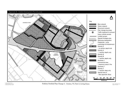
Appendix 3S - Outline Development <strong>Plan</strong> (Awatea)<br />
NORTH<br />
WARREN PARK<br />
WILMERS RD<br />
*<br />
OW AKA RD<br />
AWATEA RD<br />
Key<br />
Blue network<br />
Green network<br />
Movement network<br />
<strong>Plan</strong> change boundary<br />
Traffic treatment to prevent<br />
heavy vehicle access<br />
Limited access<br />
Special frontage area<br />
CARRS<br />
RD<br />
Motorway designation<br />
Pedestrian / cycle<br />
overbridge & embankment<br />
Density A<br />
* - no section depth limit<br />
McTEIGUE RD<br />
CARRS<br />
RESERVE<br />
Density A<br />
- 1 section depth only<br />
Density B<br />
Density B<br />
DUNBARS RD<br />
- 1 section depth only<br />
Business 1<br />
commercial area<br />
- maximum area 0.7ha<br />
WIGRAM RD<br />
WESTLAKE<br />
RESERVE<br />
Business 7<br />
Density C<br />
- 1 section deep only<br />
Special area A<br />
- See appendix 3S(a)<br />
HALSW ELL JUNCTION RD<br />
100 0 100 200 300 400 500<br />
SCALE (m)<br />
Capital Delivery Team<br />
Capital Programme Group<br />
<strong>Christchurch</strong> <strong>City</strong> <strong>Council</strong><br />
PubliclyNotified <strong>Plan</strong> <strong>Change</strong> 5 - Awatea, V3, Part 2, LivingZones<br />
Map: pp005700-8.dgn<br />
Date: 8/11/2010
Appendix 3S(a) - Fixed Structural Elements Diagram<br />
AWATEA RD<br />
NORTH<br />
WARREN PARK<br />
WILMERS RD<br />
OW AKA RD<br />
AWATEA RD<br />
Key<br />
Fixed elements associated with:<br />
Blue network elements<br />
Green network elements<br />
Location of access points<br />
on the black network<br />
<strong>Plan</strong> change boundary<br />
Motorway designation<br />
CARRS<br />
RD<br />
McTEIGUE RD<br />
CARRS<br />
RESERVE<br />
DUNBARS RD<br />
HALSW ELL JUNCTION RD<br />
WIGRAM RD<br />
WESTLAKE<br />
RESERVE<br />
100 0 100 200 300 400 500<br />
SCALE (m)<br />
Capital Delivery Team<br />
Capital Programme Group<br />
<strong>Christchurch</strong> <strong>City</strong> <strong>Council</strong><br />
PubliclyNotified <strong>Plan</strong> <strong>Change</strong> 5 - Awatea, V3, Part 2, LivingZones<br />
Map: pp005700-5.dgn<br />
Date: 8/11/2010
Appendix 3S(i) - Green Network Layer Diagram<br />
NORTH<br />
WARREN PARK<br />
WILMERS RD<br />
OW AKA RD<br />
AWATEA RD<br />
Key<br />
<strong>Plan</strong> change boundary<br />
Parks / reserves<br />
Green multiuse corridors<br />
Motorway designation<br />
CARRS<br />
RD<br />
McTEIGUE RD<br />
CARRS<br />
RESERVE<br />
DUNBARS RD<br />
HALSW ELL JUNCTION RD<br />
WIGRAM RD<br />
WESTLAKE<br />
RESERVE<br />
100 0 100 200 300 400 500<br />
SCALE (m)<br />
Capital Delivery Team<br />
Capital Programme Group<br />
<strong>Christchurch</strong> <strong>City</strong> <strong>Council</strong><br />
PubliclyNotified <strong>Plan</strong> <strong>Change</strong> 5 - Awatea, V3, Part 2, LivingZones<br />
Map: pp005700-4.dgn<br />
Date: 8/11/2010
Appendix 3S(ii) - Blue Network Layer Diagram<br />
NORTH<br />
WARREN PARK<br />
Key<br />
AWATEA RD<br />
WILMERS RD<br />
OW AKA RD<br />
CARRS RD<br />
COLLECTION<br />
SWALE<br />
HEATHCOTE<br />
RIVER<br />
<strong>Plan</strong> change boundary<br />
Proposed stormwater<br />
flow paths<br />
Swales<br />
Retention / detention basin<br />
Existing waterway removed<br />
Motorway designation<br />
OWAKA<br />
COLLECTION<br />
SWALE<br />
CARRS<br />
RD<br />
CITY<br />
CENTRE<br />
McTEIGUE RD<br />
CARRS<br />
RESERVE<br />
DUNBARS RD<br />
HALSW ELL JUNCTION RD<br />
WIGRAM RD<br />
WESTLAKE<br />
RESERVE<br />
100 0 100 200 300 400 500<br />
SCALE (m)<br />
Capital Delivery Team<br />
Capital Programme Group<br />
<strong>Christchurch</strong> <strong>City</strong> <strong>Council</strong><br />
PubiclyNotified <strong>Plan</strong> <strong>Change</strong> 5 - Awatea, V3, Part 2, LivingZones<br />
Map: pp005700-1.dgn<br />
Date: 8/11/2010
Appendix 3S(iii) - Movement Network Layer Diagram<br />
NORTH<br />
WARREN PARK<br />
WILMERS RD<br />
OW AKA RD<br />
AWATEA RD<br />
Key<br />
<strong>Plan</strong> change boundary<br />
Primary road<br />
Road to be closed<br />
Traffic treatment to prevent<br />
heavy vehicle access<br />
Motorway designation<br />
Limited access<br />
CARRS<br />
RD<br />
McTEIGUE RD<br />
CARRS<br />
RESERVE<br />
DUNBARS RD<br />
HALSW ELL JUNCTION RD<br />
WIGRAM RD<br />
WESTLAKE<br />
RESERVE<br />
100 0 100 200 300 400 500<br />
SCALE (m)<br />
Capital Delivery Team<br />
Capital Programme Group<br />
<strong>Christchurch</strong> <strong>City</strong> <strong>Council</strong><br />
PubliclyNotified <strong>Plan</strong> <strong>Change</strong> 5 - Awatea, V3, Part 2, LivingZones<br />
Map: pp005700-3.dgn<br />
Date: 8/11/2010
Appendix 3S(iv) - Cycle Network Diagram<br />
NORTH<br />
WARREN PARK<br />
Key<br />
AWATEA RD<br />
WILMERS RD<br />
HEATHCOTE<br />
RIVER<br />
Cycle network<br />
Motorway designation<br />
OW AKA RD<br />
CARRS<br />
RD<br />
CITY<br />
CENTRE<br />
McTEIGUE RD<br />
CARRS<br />
RESERVE<br />
DUNBARS RD<br />
HALSW ELL JUNCTION RD<br />
WIGRAM RD<br />
WESTLAKE<br />
RESERVE<br />
100 0 100 200 300 400 500<br />
SCALE (m)<br />
Capital Delivery Team<br />
Capital Programme Group<br />
<strong>Christchurch</strong> <strong>City</strong> <strong>Council</strong><br />
PubliclyNotified <strong>Plan</strong> <strong>Change</strong> 5 - Awatea, V3, Part 2, LivingZones<br />
Map: pp005700-2.dgn<br />
Date: 8/11/2010
Appendix 3S(v) - Public Transport Diagram<br />
NORTH<br />
WARREN PARK<br />
Key<br />
AWATEA RD<br />
WILMERS RD<br />
400mR<br />
OW AKA RD<br />
400mR<br />
400mR<br />
<strong>Plan</strong> change boundary<br />
Motorway designation<br />
Potential main bus route<br />
through block<br />
Potential extended bus<br />
route through block<br />
Potential bus stop location<br />
CARRS<br />
RD<br />
McTEIGUE RD<br />
CARRS<br />
RESERVE<br />
DUNBARS RD<br />
HALSW ELL JUNCTION RD<br />
WIGRAM RD<br />
WESTLAKE<br />
RESERVE<br />
100 0 100 200 300 400 500<br />
SCALE (m)<br />
Capital Delivery Team<br />
Capital Programme Group<br />
<strong>Christchurch</strong> <strong>City</strong> <strong>Council</strong><br />
PubliclyNotified <strong>Plan</strong> <strong>Change</strong> 5 - Awatea, V3, Part 2, LivingZones<br />
Map: pp005700-6.dgn<br />
Date: 8/11/2010
Appendix 3S(vii) - Tangata Whenua Layer Diagram<br />
NORTH<br />
WARREN PARK<br />
Key<br />
AWATEA RD<br />
WILMERS RD<br />
OW AKA RD<br />
HEATHCOTE<br />
RIVER<br />
~<br />
~ ~ ~ ~ ~ ~<br />
Traditional places & sites<br />
of significance<br />
Significant habitat corridor<br />
& waterway<br />
Traditional headwaters<br />
~<br />
~ ~ ~ ~ ~ ~<br />
CARRS<br />
RD<br />
~<br />
McTEIGUE RD<br />
CARRS<br />
RESERVE<br />
DUNBARS RD<br />
HALSW ELL JUNCTION RD<br />
WIGRAM RD<br />
WESTLAKE<br />
RESERVE<br />
100 0 100 200 300 400 500<br />
SCALE (m)<br />
Capital Delivery Team<br />
Capital Programme Group<br />
<strong>Christchurch</strong> <strong>City</strong> <strong>Council</strong><br />
PubliclyNotified <strong>Plan</strong> <strong>Change</strong> 5 - Awatea, V3, Part 2, LivingZones<br />
Map: pp005700-9.dgn<br />
Date: 8/11/2010
Appendix 3S(vi) - Road Design Parameters<br />
Table 1: Minimum Design elements for Local Roads in residential areas<br />
Table 1 Notes<br />
Street Type<br />
Minimum<br />
legal road<br />
width<br />
Indicative<br />
legal<br />
road<br />
width<br />
Minimum<br />
carriageway<br />
width<br />
Minimum<br />
number of<br />
footpaths<br />
Minimum<br />
footpath<br />
width<br />
Provision<br />
of street<br />
trees<br />
Minimum<br />
level of<br />
amenity<br />
coverage<br />
Note (1)<br />
Minimum<br />
on-street<br />
parking<br />
requirement<br />
Driveway<br />
spacing<br />
Parameter<br />
Res Res<br />
A B & C<br />
(1)<br />
*<br />
The minimum portion of legal road width that is designated for community features.<br />
Amenity on all local streets shall be provided continuously on both sides of the street,<br />
only broken by vehicle or path crossing points.<br />
Two footpaths are required except for sections of streets with frontage to Conservation,<br />
Open Space or Rural Zones where one footpath may be provided within the legal road.<br />
Where one footpath is provided, it must be located on the residential side of the street.<br />
Short local<br />
street<br />
12m<br />
Note (2)<br />
6.0m<br />
1<br />
1.5m<br />
Yes<br />
25%<br />
1 space for every<br />
3 residential units<br />
0.75<br />
0.80<br />
(2)<br />
See calculation formula below to determine Indicative Legal Road Widthwhere<br />
amenity coverage is provided continuously or in discrete clusters.<br />
Typical local<br />
street<br />
Local distributor<br />
street<br />
15m<br />
17m<br />
Note (2)<br />
Note (2)<br />
7.5m<br />
9.0m<br />
2*<br />
2*<br />
1.5m<br />
1.5m<br />
Yes<br />
Yes<br />
20%<br />
20%<br />
1 space for every<br />
3 residential units<br />
1 space for every<br />
3 residential units<br />
0.75<br />
0.75<br />
0.80<br />
0.80<br />
Res A - High Density Residential A Area.<br />
Res B - Meduim Density Residential B Area.<br />
Res C - Low Density Residential C Area.<br />
Local street<br />
(bus route)<br />
18m<br />
Note (2)<br />
9.5m<br />
2<br />
1.5m<br />
Yes<br />
20%<br />
1 space for every<br />
3 residential units<br />
0.75<br />
0.80<br />
Table 2: Minimum Design elements for Primary and Collector Roads<br />
Table 2 Notes<br />
Zoning<br />
Business 7<br />
zone<br />
Minimum<br />
legal road<br />
width<br />
22m<br />
Indicative<br />
legal<br />
road<br />
width<br />
Note (6)<br />
Minimum<br />
traffic<br />
lane<br />
width<br />
Note (3)<br />
3.2m<br />
Minimum<br />
number of<br />
footpaths<br />
2<br />
Minimum<br />
footpath<br />
width<br />
1.5m<br />
On street<br />
cycle<br />
lanes<br />
Note (4)<br />
Yes<br />
Provision<br />
of street<br />
trees<br />
Optional<br />
Minimum<br />
level of<br />
amenity<br />
coverage<br />
Note (5)<br />
5% or 50m†<br />
Driveway<br />
spacing<br />
Parameter<br />
0.90<br />
(3)<br />
(4)<br />
(5)<br />
The minimum traffic lane width shall be increased to 3.2m if the primary or<br />
collector road forms part of a bus route.<br />
On street cycle lanes shall be designed in accordance with the NZ supplement<br />
to Austroads Guide to Traffic Engineering Practice Part 14: Bicycles.<br />
Where amenity is provided continuously the specific percentages shall apply.<br />
Where amenity is provided in discrete clusters the area (per 100m lineal length of road)<br />
shall apply.<br />
All living<br />
zones<br />
All other<br />
zones<br />
20m<br />
19m<br />
Note (6)<br />
Note (6)<br />
3.0m<br />
3.0m<br />
2<br />
2<br />
1.5m<br />
1.5m<br />
Yes<br />
Yes<br />
Yes 10%<br />
Optional 5% or 50m†<br />
Res A - 0.75<br />
Res B - 0.80<br />
Res C - 0.80<br />
0.95<br />
(6)<br />
See calculation formula below to determine Indicative Legal Road Widthwhere<br />
amenity coverage is provided continuously or in discrete clusters.<br />
Res A - High Density Residential A Area.<br />
Res B - Meduim Density Residential B Area.<br />
Res C - Low Density Residential C Area.<br />
Terminology<br />
Local Short Street<br />
Local Typical Street<br />
Local Distributor Street<br />
Local Street (Bus Route)<br />
All streets in the Living G Zone that are less than 150m in length<br />
and serve a maximum of 25 potential residential units.<br />
All streets that do not meet the criteria of a Local Short Street<br />
or Local Distributor Street.<br />
All streets that intersect with a Collector, Minor or Major Arterial Road<br />
and have intersections with at least two other Local Typical Streets.<br />
Any of the above Local Streets that forms part of a future bus route.<br />
Indicative Legal Road Width Formula<br />
On streets where amenity is provided continuously, the indicative legal road width shall be calculated using the following formula:<br />
Indicative Legal Road Width (Continuous Amenity) = ( A + B ) / ( 1 - ( C / D )<br />
Where:<br />
A = proposed carriageway width (in metres)<br />
B = proposed combined width of footpaths (in metres)<br />
C = minimum level of amenity coverage (expressed as a decimal)<br />
D = driveway spacing parameter (expressed as a decimal)<br />
On streets where amenity is provided in discrete clusters, the indicative legal road width shall be calculated using the following formula:<br />
Indicative Legal Road Width (Discrete Amenity) = ( A + B ) / ( 1 - C )<br />
Where:<br />
A = proposed carriageway width (in metres)<br />
B = proposed combined width of footpaths (in metres)<br />
C = minimum level of amenity coverage (expressed as a decimal)<br />
Capital Delivery Team<br />
Capital Programme Group<br />
<strong>Christchurch</strong> <strong>City</strong> <strong>Council</strong><br />
Proposed <strong>Plan</strong> <strong>Change</strong> 5 - Awatea, V3, Part 2, LivingZones<br />
Map: pp005600-7.dgn<br />
Date: 18/12/2009